Deprecated: Creation of dynamic property Zend_View::$sMode is deprecated in /var/www/stall-frei/htdocs/staging.stall-frei.de/library/vendor/shardj/zf1-future/library/Zend/View/Abstract.php on line 308
Dienstleistung
Gesucht wird in "25337 Pinneberg, Deutschland"
478 Einträge
Deprecated: Creation of dynamic property Zend_View::$listObjects is deprecated in /var/www/stall-frei/htdocs/staging.stall-frei.de/library/vendor/shardj/zf1-future/library/Zend/View/Abstract.php on line 308
Deprecated: Creation of dynamic property Zend_View::$listMode is deprecated in /var/www/stall-frei/htdocs/staging.stall-frei.de/library/vendor/shardj/zf1-future/library/Zend/View/Abstract.php on line 308
Deprecated: Creation of dynamic property Zend_View::$renderedObjects is deprecated in /var/www/stall-frei/htdocs/staging.stall-frei.de/library/vendor/shardj/zf1-future/library/Zend/View/Abstract.php on line 308
Deprecated: Creation of dynamic property Zend_View::$index is deprecated in /var/www/stall-frei/htdocs/staging.stall-frei.de/library/vendor/shardj/zf1-future/library/Zend/View/Abstract.php on line 308
Deprecated: Creation of dynamic property Zend_View::$displayMode is deprecated in /var/www/stall-frei/htdocs/staging.stall-frei.de/library/vendor/shardj/zf1-future/library/Zend/View/Abstract.php on line 308
Deprecated: Creation of dynamic property Zend_View::$remarketingIds is deprecated in /var/www/stall-frei/htdocs/staging.stall-frei.de/library/vendor/shardj/zf1-future/library/Zend/View/Abstract.php on line 308
Deprecated: Creation of dynamic property Zend_View::$listItem is deprecated in /var/www/stall-frei/htdocs/staging.stall-frei.de/library/vendor/shardj/zf1-future/library/Zend/View/Abstract.php on line 308
Deprecated: Creation of dynamic property Zend_View::$object is deprecated in /var/www/stall-frei/htdocs/staging.stall-frei.de/library/vendor/shardj/zf1-future/library/Zend/View/Abstract.php on line 308
Deprecated: Creation of dynamic property Zend_View::$attributes is deprecated in /var/www/stall-frei/htdocs/staging.stall-frei.de/library/vendor/shardj/zf1-future/library/Zend/View/Abstract.php on line 308

Heilung für Mensch und Tier
Moorrege
Marion-Moyses
@Marion-Moyses
Beratung rund ums Pferd
Tierkommunikation
Bachblütentherapie
Reiki bei Pferden
B+
Deprecated: Creation of dynamic property Zend_View_Helper_Ads::$adLink is deprecated in /var/www/stall-frei/htdocs/staging.stall-frei.de/library/Psf/View/Helper/Ads.php on line 108

Futtersack HeuToy, Fressbremse in pink
Mechtersen
STALL-FREIde Marketing
@STALL-FREI-Marketing
Stundenlange Beschäftigung die
Koliken vorbeugt, geringe Staubinhalation mit
steuerbarer Futterentnahme

Osteopathie Physiotherapie Akupunktur Pferd &...
Neuendeich
Pferdepension Neuendeich
@Pferdepension-Neuendeich
Bodenarbeit
Ergotherapeut
Beratung rund ums Pferd
Akupressur
Akupunktur
13 weitere...
B+


Traumasensibles Coaching für Pferd + Mensch
Hamburg
Katja Hammerschmidt
@KatjaHammerschmidtHamburg
Coaching
Beratung rund ums Pferd
Tierfotografie
Andere Heilverfahren
Osteopathie
3 weitere...
P+
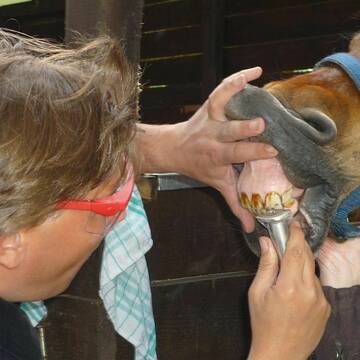
EQUIDENS - Pferdedentist für Hamburg und Umgebun...
Pinneberg
equidens
@equidens
Pferdedentist, Pferdezahnpflege
B+
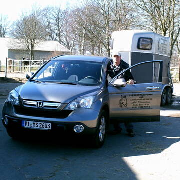
Pferdetransporte und Anhängerverleih
Schenefeld
Manfred Schröder
@Manfred
Kleintiertransport
Pferdeanhängervermietung
Transport mit dem Pferd
1 weitere...
B+

Kunstmalerin Rosita Engelmohr
Henstedt Ulzburg
Kunstmalerin Rosita Engelmohr
@Kunstmalerin
Pferdeausbildung
Reitunterricht: Dressur
Futtermittel: Herstellung
Futtermittel: Ladengeschäft
Deckstation
Fohlenzucht
Fohlennotdienst
Kleintiertransport
25 weitere...
B+

Beritt,Anreiten, Ausbilden Vielseitig
Bimöhlen
Desiree Schaeffer
@DS_Sporthorses
Longenarbeit
Pferdeausbildung
Pferdeverkauf
Pferdevermittlung
Beratung rund ums Pferd
6 weitere...
B+

Reitbeteiligung auf toller Isländer Scheckstute
Wulfsen
Scharlih
@Scharlih
Ribanna,bildhübsche,1,46c m gr.Isländer schwarz-weiß Scheckstute,4 gängig.Gut ausgebildet, gelehrig-zum Verlieben!Tolles Ausreitgelände!
neu
R

Hufpflege / Pferdephysiotherapie und -osteopathie
Bimöhlen
Jill Sophie Dahnke
@Wohlfuehlpferde
Hufpfleger
Beratung rund ums Pferd
Osteopathie
Pferdemassage
1 weitere...
B+


Ausbildung Pferd und Reiter / begradigen Reitboden
Kükels
Winklers-Hof
@Winklers-Hof
Fahrsport
Longenarbeit
Beratung rund ums Pferd
Kutschfahrten
8 weitere...
P+


Bedampftes Heu - bzw. Lohnbedampfung
Kükels
Winklers-Hof
@Winklers-Hof
Futtermittel: Herstellung
Futtermittel: Lieferung oder Versand
Lohnunternehmen
P+
Deprecated: Creation of dynamic property Zend_View::$pageCount is deprecated in /var/www/stall-frei/htdocs/staging.stall-frei.de/library/vendor/shardj/zf1-future/library/Zend/View/Abstract.php on line 308
Deprecated: Creation of dynamic property Zend_View::$itemCountPerPage is deprecated in /var/www/stall-frei/htdocs/staging.stall-frei.de/library/vendor/shardj/zf1-future/library/Zend/View/Abstract.php on line 308
Deprecated: Creation of dynamic property Zend_View::$first is deprecated in /var/www/stall-frei/htdocs/staging.stall-frei.de/library/vendor/shardj/zf1-future/library/Zend/View/Abstract.php on line 308
Deprecated: Creation of dynamic property Zend_View::$current is deprecated in /var/www/stall-frei/htdocs/staging.stall-frei.de/library/vendor/shardj/zf1-future/library/Zend/View/Abstract.php on line 308
Deprecated: Creation of dynamic property Zend_View::$last is deprecated in /var/www/stall-frei/htdocs/staging.stall-frei.de/library/vendor/shardj/zf1-future/library/Zend/View/Abstract.php on line 308
Deprecated: Creation of dynamic property Zend_View::$next is deprecated in /var/www/stall-frei/htdocs/staging.stall-frei.de/library/vendor/shardj/zf1-future/library/Zend/View/Abstract.php on line 308
Deprecated: Creation of dynamic property Zend_View::$pagesInRange is deprecated in /var/www/stall-frei/htdocs/staging.stall-frei.de/library/vendor/shardj/zf1-future/library/Zend/View/Abstract.php on line 308
Deprecated: Creation of dynamic property Zend_View::$firstPageInRange is deprecated in /var/www/stall-frei/htdocs/staging.stall-frei.de/library/vendor/shardj/zf1-future/library/Zend/View/Abstract.php on line 308
Deprecated: Creation of dynamic property Zend_View::$lastPageInRange is deprecated in /var/www/stall-frei/htdocs/staging.stall-frei.de/library/vendor/shardj/zf1-future/library/Zend/View/Abstract.php on line 308
Deprecated: Creation of dynamic property Zend_View::$currentItemCount is deprecated in /var/www/stall-frei/htdocs/staging.stall-frei.de/library/vendor/shardj/zf1-future/library/Zend/View/Abstract.php on line 308
Deprecated: Creation of dynamic property Zend_View::$totalItemCount is deprecated in /var/www/stall-frei/htdocs/staging.stall-frei.de/library/vendor/shardj/zf1-future/library/Zend/View/Abstract.php on line 308
Deprecated: Creation of dynamic property Zend_View::$firstItemNumber is deprecated in /var/www/stall-frei/htdocs/staging.stall-frei.de/library/vendor/shardj/zf1-future/library/Zend/View/Abstract.php on line 308
Deprecated: Creation of dynamic property Zend_View::$lastItemNumber is deprecated in /var/www/stall-frei/htdocs/staging.stall-frei.de/library/vendor/shardj/zf1-future/library/Zend/View/Abstract.php on line 308
Deprecated: Creation of dynamic property Zend_View::$router is deprecated in /var/www/stall-frei/htdocs/staging.stall-frei.de/library/vendor/shardj/zf1-future/library/Zend/View/Abstract.php on line 308
Deprecated: Creation of dynamic property Zend_View::$urlParams is deprecated in /var/www/stall-frei/htdocs/staging.stall-frei.de/library/vendor/shardj/zf1-future/library/Zend/View/Abstract.php on line 308
Deprecated: Creation of dynamic property Zend_View::$showAds is deprecated in /var/www/stall-frei/htdocs/staging.stall-frei.de/library/vendor/shardj/zf1-future/library/Zend/View/Abstract.php on line 308
Deprecated: Creation of dynamic property Zend_View::$objectIds is deprecated in /var/www/stall-frei/htdocs/staging.stall-frei.de/library/vendor/shardj/zf1-future/library/Zend/View/Abstract.php on line 308
Deprecated: Creation of dynamic property Zend_View::$showNavbar is deprecated in /var/www/stall-frei/htdocs/staging.stall-frei.de/library/vendor/shardj/zf1-future/library/Zend/View/Abstract.php on line 308
Deprecated: Creation of dynamic property Zend_View::$showBreadcrumb is deprecated in /var/www/stall-frei/htdocs/staging.stall-frei.de/library/vendor/shardj/zf1-future/library/Zend/View/Abstract.php on line 308
Deprecated: Creation of dynamic property Zend_View::$showFooter is deprecated in /var/www/stall-frei/htdocs/staging.stall-frei.de/library/vendor/shardj/zf1-future/library/Zend/View/Abstract.php on line 308
Deprecated: Creation of dynamic property Zend_View::$showInternalAds is deprecated in /var/www/stall-frei/htdocs/staging.stall-frei.de/library/vendor/shardj/zf1-future/library/Zend/View/Abstract.php on line 308
Deprecated: Creation of dynamic property Zend_View::$blNoContent is deprecated in /var/www/stall-frei/htdocs/staging.stall-frei.de/library/vendor/shardj/zf1-future/library/Zend/View/Abstract.php on line 308
Deprecated: Creation of dynamic property Zend_View::$sMetaDesc is deprecated in /var/www/stall-frei/htdocs/staging.stall-frei.de/library/vendor/shardj/zf1-future/library/Zend/View/Abstract.php on line 308
Deprecated: Creation of dynamic property Zend_View::$useGmaps is deprecated in /var/www/stall-frei/htdocs/staging.stall-frei.de/library/vendor/shardj/zf1-future/library/Zend/View/Abstract.php on line 308
Deprecated: Creation of dynamic property Zend_View::$touches is deprecated in /var/www/stall-frei/htdocs/staging.stall-frei.de/library/vendor/shardj/zf1-future/library/Zend/View/Abstract.php on line 308
Deprecated: Creation of dynamic property Zend_View::$oProject is deprecated in /var/www/stall-frei/htdocs/staging.stall-frei.de/library/vendor/shardj/zf1-future/library/Zend/View/Abstract.php on line 308
Deprecated: Creation of dynamic property Zend_View::$pageHeadline is deprecated in /var/www/stall-frei/htdocs/staging.stall-frei.de/library/vendor/shardj/zf1-future/library/Zend/View/Abstract.php on line 308
Deprecated: Creation of dynamic property Zend_View::$disableLocationField is deprecated in /var/www/stall-frei/htdocs/staging.stall-frei.de/library/vendor/shardj/zf1-future/library/Zend/View/Abstract.php on line 308
Deprecated: Creation of dynamic property Zend_View::$isSearch is deprecated in /var/www/stall-frei/htdocs/staging.stall-frei.de/library/vendor/shardj/zf1-future/library/Zend/View/Abstract.php on line 308
Deprecated: Creation of dynamic property Zend_View::$pageTitle is deprecated in /var/www/stall-frei/htdocs/staging.stall-frei.de/library/vendor/shardj/zf1-future/library/Zend/View/Abstract.php on line 308
Deprecated: Creation of dynamic property Psf_Form_Element_Text::$class is deprecated in /var/www/stall-frei/htdocs/staging.stall-frei.de/library/vendor/shardj/zf1-future/library/Zend/Form/Element.php on line 874
Deprecated: Creation of dynamic property Psf_Form_Element_Text::$size is deprecated in /var/www/stall-frei/htdocs/staging.stall-frei.de/library/vendor/shardj/zf1-future/library/Zend/Form/Element.php on line 874
Deprecated: Creation of dynamic property Psf_Form_Element_Text::$placeholder is deprecated in /var/www/stall-frei/htdocs/staging.stall-frei.de/library/vendor/shardj/zf1-future/library/Zend/Form/Element.php on line 874
Deprecated: Creation of dynamic property Psf_Form_Element_Hidden::$class is deprecated in /var/www/stall-frei/htdocs/staging.stall-frei.de/library/vendor/shardj/zf1-future/library/Zend/Form/Element.php on line 874
Deprecated: Creation of dynamic property Psf_Form_Element_Hidden::$class is deprecated in /var/www/stall-frei/htdocs/staging.stall-frei.de/library/vendor/shardj/zf1-future/library/Zend/Form/Element.php on line 874
Deprecated: Creation of dynamic property Psf_Form_Element_Hidden::$class is deprecated in /var/www/stall-frei/htdocs/staging.stall-frei.de/library/vendor/shardj/zf1-future/library/Zend/Form/Element.php on line 874
Deprecated: Creation of dynamic property Psf_Form_Element_Hidden::$class is deprecated in /var/www/stall-frei/htdocs/staging.stall-frei.de/library/vendor/shardj/zf1-future/library/Zend/Form/Element.php on line 874
Deprecated: Creation of dynamic property Psf_Form_Element_Select::$class is deprecated in /var/www/stall-frei/htdocs/staging.stall-frei.de/library/vendor/shardj/zf1-future/library/Zend/Form/Element.php on line 874
Deprecated: Creation of dynamic property Psf_Form_Element_Text::$class is deprecated in /var/www/stall-frei/htdocs/staging.stall-frei.de/library/vendor/shardj/zf1-future/library/Zend/Form/Element.php on line 874
Deprecated: Creation of dynamic property Psf_Form_Element_Checkbox::$label is deprecated in /var/www/stall-frei/htdocs/staging.stall-frei.de/library/vendor/shardj/zf1-future/library/Zend/Form/Element.php on line 874
Deprecated: Creation of dynamic property Zend_View::$sort is deprecated in /var/www/stall-frei/htdocs/staging.stall-frei.de/library/vendor/shardj/zf1-future/library/Zend/View/Abstract.php on line 308
Deprecated: Creation of dynamic property Zend_View::$searchLocation is deprecated in /var/www/stall-frei/htdocs/staging.stall-frei.de/library/vendor/shardj/zf1-future/library/Zend/View/Abstract.php on line 308
Deprecated: Creation of dynamic property Zend_View::$locationHint is deprecated in /var/www/stall-frei/htdocs/staging.stall-frei.de/library/vendor/shardj/zf1-future/library/Zend/View/Abstract.php on line 308
Psf_GeoCoder_Abstract::getLocation: Pinneberg Get Location CachedOrLive
Psf_GeoCoder_Abstract::getCachedOrLive: Pinneberg
Psf_GeoCoder_OpenCageData::makeApiRequest: response:
Array
(
[documentation] => https://opencagedata.com/api
[licenses] => Array
(
[0] => Array
(
[name] => see attribution guide
[url] => https://opencagedata.com/credits
)
)
[results] => Array
(
[0] => Array
(
[bounds] => Array
(
[northeast] => Array
(
[lat] => 54.4278939
[lng] => 10.3979598
)
[southwest] => Array
(
[lat] => 53.0278939
[lng] => 8.9979598
)
)
[components] => Array
(
[ISO_3166-1_alpha-2] => DE
[ISO_3166-1_alpha-3] => DEU
[ISO_3166-2] => Array
(
[0] => DE-SH
)
[_category] => place
[_type] => county
[continent] => Europe
[country] => Deutschland
[country_code] => de
[county] => Pinneberg
[political_union] => European Union
[postcode] => 25337
[state] => Schleswig-Holstein
[state_code] => SH
)
[confidence] => 1
[formatted] => 25337 Pinneberg, Deutschland
[geometry] => Array
(
[lat] => 53.7278939
[lng] => 9.6979598
)
)
[1] => Array
(
[bounds] => Array
(
[northeast] => Array
(
[lat] => 53.6838731
[lng] => 9.8285585
)
[southwest] => Array
(
[lat] => 53.6086307
[lng] => 9.7636444
)
)
[components] => Array
(
[ISO_3166-1_alpha-2] => DE
[ISO_3166-1_alpha-3] => DEU
[ISO_3166-2] => Array
(
[0] => DE-SH
)
[_category] => place
[_normalized_city] => Pinneberg
[_type] => municipality
[continent] => Europe
[country] => Deutschland
[country_code] => de
[county] => Kreis Pinneberg
[municipality] => Pinneberg
[political_union] => European Union
[postcode] => 25421
[state] => Schleswig-Holstein
[state_code] => SH
)
[confidence] => 7
[formatted] => 25421 Pinneberg, Deutschland
[geometry] => Array
(
[lat] => 53.6558152
[lng] => 9.8016369
)
)
[2] => Array
(
[bounds] => Array
(
[northeast] => Array
(
[lat] => 53.7015177
[lng] => 9.8367897
)
[southwest] => Array
(
[lat] => 53.6215177
[lng] => 9.7567897
)
)
[components] => Array
(
[ISO_3166-1_alpha-2] => DE
[ISO_3166-1_alpha-3] => DEU
[ISO_3166-2] => Array
(
[0] => DE-SH
)
[_category] => place
[_normalized_city] => Pinneberg
[_type] => city
[continent] => Europe
[country] => Deutschland
[country_code] => de
[county] => Kreis Pinneberg
[municipality] => Pinneberg
[political_union] => European Union
[postcode] => 25421
[state] => Schleswig-Holstein
[state_code] => SH
[town] => Pinneberg
)
[confidence] => 7
[formatted] => 25421 Pinneberg, Deutschland
[geometry] => Array
(
[lat] => 53.6615177
[lng] => 9.7967897
)
)
[3] => Array
(
[components] => Array
(
[ISO_3166-1_alpha-2] => FR
[ISO_3166-1_alpha-3] => FRA
[ISO_3166-2] => Array
(
[0] => FR-BRE
[1] => FR-35
)
[_category] => road
[_normalized_city] => Dourdain
[_type] => road
[city] => Dourdain
[continent] => Europe
[country] => France
[country_code] => fr
[county] => Ille-et-Vilaine
[local_authority] => Liffré-Cormier Communauté
[political_union] => European Union
[postcode] => 35450
[road] => Lieu Dit la Lande Guinebert
[state] => Bretagne
[state_code] => BRE
)
[confidence] => 3
[formatted] => Lieu Dit la Lande Guinebert, 35450 Dourdain, France
[geometry] => Array
(
[lat] => 48.184881
[lng] => -1.370024
)
)
[4] => Array
(
[components] => Array
(
[ISO_3166-1_alpha-2] => FR
[ISO_3166-1_alpha-3] => FRA
[ISO_3166-2] => Array
(
[0] => FR-ARA
[1] => FR-03
)
[_category] => road
[_normalized_city] => Montluçon
[_type] => road
[city] => Montluçon
[continent] => Europe
[country] => France
[country_code] => fr
[county] => Allier
[local_authority] => Montluçon Communauté
[political_union] => European Union
[postcode] => 03100
[road] => Avenue des Guineberts
[state] => Auvergne-Rhône-Alpes
[state_code] => ARA
)
[confidence] => 2
[formatted] => Avenue des Guineberts, 03100 Montluçon, France
[geometry] => Array
(
[lat] => 46.33311
[lng] => 2.592643
)
)
[5] => Array
(
[components] => Array
(
[ISO_3166-1_alpha-2] => FR
[ISO_3166-1_alpha-3] => FRA
[ISO_3166-2] => Array
(
[0] => FR-NAQ
[1] => FR-33
)
[_category] => road
[_normalized_city] => Arcachon
[_type] => road
[city] => Arcachon
[continent] => Europe
[country] => France
[country_code] => fr
[county] => Gironde
[local_authority] => Communauté d'agglomération Bassin d'Arcachon Sud
[political_union] => European Union
[postcode] => 33120
[road] => Rue Lucien Pinneberg
[state] => Nouvelle-Aquitaine
[state_code] => NAQ
)
[confidence] => 2
[formatted] => Rue Lucien Pinneberg, 33120 Arcachon, France
[geometry] => Array
(
[lat] => 44.660193
[lng] => -1.1703
)
)
[6] => Array
(
[components] => Array
(
[ISO_3166-1_alpha-2] => FR
[ISO_3166-1_alpha-3] => FRA
[ISO_3166-2] => Array
(
[0] => FR-NAQ
[1] => FR-33
)
[_category] => road
[_normalized_city] => Arcachon
[_type] => road
[city] => Arcachon
[continent] => Europe
[country] => France
[country_code] => fr
[county] => Gironde
[local_authority] => Communauté d'agglomération Bassin d'Arcachon Sud
[political_union] => European Union
[postcode] => 33120
[road] => Escalier Lucien Pinneberg
[state] => Nouvelle-Aquitaine
[state_code] => NAQ
)
[confidence] => 2
[formatted] => Escalier Lucien Pinneberg, 33120 Arcachon, France
[geometry] => Array
(
[lat] => 44.65914
[lng] => -1.170513
)
)
[7] => Array
(
[components] => Array
(
[ISO_3166-1_alpha-2] => FR
[ISO_3166-1_alpha-3] => FRA
[ISO_3166-2] => Array
(
[0] => FR-IDF
[1] => FR-77
)
[_category] => place
[_normalized_city] => Saint-Pierre-lès-Nemours
[_type] => place
[city] => Saint-Pierre-lès-Nemours
[continent] => Europe
[country] => France
[country_code] => fr
[county] => Seine-et-Marne
[local_authority] => Communauté de communes Pays de Nemours
[place] => Le Haut de Guinebert
[political_union] => European Union
[postcode] => 77140
[state] => Île-de-France
[state_code] => IDF
)
[confidence] => 2
[formatted] => Le Haut de Guinebert, 77140 Saint-Pierre-lès-Nemours, France
[geometry] => Array
(
[lat] => 48.272754
[lng] => 2.678194
)
)
[8] => Array
(
[components] => Array
(
[ISO_3166-1_alpha-2] => FR
[ISO_3166-1_alpha-3] => FRA
[ISO_3166-2] => Array
(
[0] => FR-ARA
[1] => FR-03
)
[_category] => road
[_normalized_city] => Montluçon
[_type] => road
[city] => Montluçon
[continent] => Europe
[country] => France
[country_code] => fr
[county] => Allier
[local_authority] => Montluçon Communauté
[political_union] => European Union
[postcode] => 03100
[road] => Rue de la Carr des Guineberts
[state] => Auvergne-Rhône-Alpes
[state_code] => ARA
)
[confidence] => 2
[formatted] => Rue de la Carr des Guineberts, 03100 Montluçon, France
[geometry] => Array
(
[lat] => 46.332192
[lng] => 2.586499
)
)
[9] => Array
(
[components] => Array
(
[ISO_3166-1_alpha-2] => FR
[ISO_3166-1_alpha-3] => FRA
[ISO_3166-2] => Array
(
[0] => FR-BRE
[1] => FR-56
)
[_category] => road
[_normalized_city] => Carentoir
[_type] => road
[city] => Carentoir
[continent] => Europe
[country] => France
[country_code] => fr
[county] => Morbihan
[local_authority] => De l'Oust à Brocéliande Communauté
[political_union] => European Union
[postcode] => 56910
[road] => La Roche Guinebert
[state] => Bretagne
[state_code] => BRE
)
[confidence] => 2
[formatted] => La Roche Guinebert, 56910 Carentoir, France
[geometry] => Array
(
[lat] => 47.841673
[lng] => -2.119819
)
)
)
[status] => Array
(
[code] => 200
[message] => OK
)
[stay_informed] => Array
(
[blog] => https://blog.opencagedata.com
[mastodon] => https://en.osm.town/@opencage
)
[thanks] => For using an OpenCage API
[timestamp] => Array
(
[created_http] => Fri, 16 Jan 2026 20:55:33 GMT
[created_unix] => 1768596933
)
[total_results] => 10
)
Psf_GeoCoder_Abstract::convertLocationResult
{"documentation":"https:\/\/opencagedata.com\/api","licenses":[{"name":"see attribution guide","url":"https:\/\/opencagedata.com\/credits"}],"results":[{"bounds":{"northeast":{"lat":54.4278939,"lng":10.3979598},"southwest":{"lat":53.0278939,"lng":8.9979598}},"components":{"ISO_3166-1_alpha-2":"DE","ISO_3166-1_alpha-3":"DEU","ISO_3166-2":["DE-SH"],"_category":"place","_type":"county","continent":"Europe","country":"Deutschland","country_code":"de","county":"Pinneberg","political_union":"European Union","postcode":"25337","state":"Schleswig-Holstein","state_code":"SH"},"confidence":1,"formatted":"25337 Pinneberg, Deutschland","geometry":{"lat":53.7278939,"lng":9.6979598}},{"bounds":{"northeast":{"lat":53.6838731,"lng":9.8285585},"southwest":{"lat":53.6086307,"lng":9.7636444}},"components":{"ISO_3166-1_alpha-2":"DE","ISO_3166-1_alpha-3":"DEU","ISO_3166-2":["DE-SH"],"_category":"place","_normalized_city":"Pinneberg","_type":"municipality","continent":"Europe","country":"Deutschland","country_code":"de","county":"Kreis Pinneberg","municipality":"Pinneberg","political_union":"European Union","postcode":"25421","state":"Schleswig-Holstein","state_code":"SH"},"confidence":7,"formatted":"25421 Pinneberg, Deutschland","geometry":{"lat":53.6558152,"lng":9.8016369}},{"bounds":{"northeast":{"lat":53.7015177,"lng":9.8367897},"southwest":{"lat":53.6215177,"lng":9.7567897}},"components":{"ISO_3166-1_alpha-2":"DE","ISO_3166-1_alpha-3":"DEU","ISO_3166-2":["DE-SH"],"_category":"place","_normalized_city":"Pinneberg","_type":"city","continent":"Europe","country":"Deutschland","country_code":"de","county":"Kreis Pinneberg","municipality":"Pinneberg","political_union":"European Union","postcode":"25421","state":"Schleswig-Holstein","state_code":"SH","town":"Pinneberg"},"confidence":7,"formatted":"25421 Pinneberg, Deutschland","geometry":{"lat":53.6615177,"lng":9.7967897}},{"components":{"ISO_3166-1_alpha-2":"FR","ISO_3166-1_alpha-3":"FRA","ISO_3166-2":["FR-BRE","FR-35"],"_category":"road","_normalized_city":"Dourdain","_type":"road","city":"Dourdain","continent":"Europe","country":"France","country_code":"fr","county":"Ille-et-Vilaine","local_authority":"Liffr\u00e9-Cormier Communaut\u00e9","political_union":"European Union","postcode":"35450","road":"Lieu Dit la Lande Guinebert","state":"Bretagne","state_code":"BRE"},"confidence":3,"formatted":"Lieu Dit la Lande Guinebert, 35450 Dourdain, France","geometry":{"lat":48.184881,"lng":-1.370024}},{"components":{"ISO_3166-1_alpha-2":"FR","ISO_3166-1_alpha-3":"FRA","ISO_3166-2":["FR-ARA","FR-03"],"_category":"road","_normalized_city":"Montlu\u00e7on","_type":"road","city":"Montlu\u00e7on","continent":"Europe","country":"France","country_code":"fr","county":"Allier","local_authority":"Montlu\u00e7on Communaut\u00e9","political_union":"European Union","postcode":"03100","road":"Avenue des Guineberts","state":"Auvergne-Rh\u00f4ne-Alpes","state_code":"ARA"},"confidence":2,"formatted":"Avenue des Guineberts, 03100 Montlu\u00e7on, France","geometry":{"lat":46.33311,"lng":2.592643}},{"components":{"ISO_3166-1_alpha-2":"FR","ISO_3166-1_alpha-3":"FRA","ISO_3166-2":["FR-NAQ","FR-33"],"_category":"road","_normalized_city":"Arcachon","_type":"road","city":"Arcachon","continent":"Europe","country":"France","country_code":"fr","county":"Gironde","local_authority":"Communaut\u00e9 d'agglom\u00e9ration Bassin d'Arcachon Sud","political_union":"European Union","postcode":"33120","road":"Rue Lucien Pinneberg","state":"Nouvelle-Aquitaine","state_code":"NAQ"},"confidence":2,"formatted":"Rue Lucien Pinneberg, 33120 Arcachon, France","geometry":{"lat":44.660193,"lng":-1.1703}},{"components":{"ISO_3166-1_alpha-2":"FR","ISO_3166-1_alpha-3":"FRA","ISO_3166-2":["FR-NAQ","FR-33"],"_category":"road","_normalized_city":"Arcachon","_type":"road","city":"Arcachon","continent":"Europe","country":"France","country_code":"fr","county":"Gironde","local_authority":"Communaut\u00e9 d'agglom\u00e9ration Bassin d'Arcachon Sud","political_union":"European Union","postcode":"33120","road":"Escalier Lucien Pinneberg","state":"Nouvelle-Aquitaine","state_code":"NAQ"},"confidence":2,"formatted":"Escalier Lucien Pinneberg, 33120 Arcachon, France","geometry":{"lat":44.65914,"lng":-1.170513}},{"components":{"ISO_3166-1_alpha-2":"FR","ISO_3166-1_alpha-3":"FRA","ISO_3166-2":["FR-IDF","FR-77"],"_category":"place","_normalized_city":"Saint-Pierre-l\u00e8s-Nemours","_type":"place","city":"Saint-Pierre-l\u00e8s-Nemours","continent":"Europe","country":"France","country_code":"fr","county":"Seine-et-Marne","local_authority":"Communaut\u00e9 de communes Pays de Nemours","place":"Le Haut de Guinebert","political_union":"European Union","postcode":"77140","state":"\u00cele-de-France","state_code":"IDF"},"confidence":2,"formatted":"Le Haut de Guinebert, 77140 Saint-Pierre-l\u00e8s-Nemours, France","geometry":{"lat":48.272754,"lng":2.678194}},{"components":{"ISO_3166-1_alpha-2":"FR","ISO_3166-1_alpha-3":"FRA","ISO_3166-2":["FR-ARA","FR-03"],"_category":"road","_normalized_city":"Montlu\u00e7on","_type":"road","city":"Montlu\u00e7on","continent":"Europe","country":"France","country_code":"fr","county":"Allier","local_authority":"Montlu\u00e7on Communaut\u00e9","political_union":"European Union","postcode":"03100","road":"Rue de la Carr des Guineberts","state":"Auvergne-Rh\u00f4ne-Alpes","state_code":"ARA"},"confidence":2,"formatted":"Rue de la Carr des Guineberts, 03100 Montlu\u00e7on, France","geometry":{"lat":46.332192,"lng":2.586499}},{"components":{"ISO_3166-1_alpha-2":"FR","ISO_3166-1_alpha-3":"FRA","ISO_3166-2":["FR-BRE","FR-56"],"_category":"road","_normalized_city":"Carentoir","_type":"road","city":"Carentoir","continent":"Europe","country":"France","country_code":"fr","county":"Morbihan","local_authority":"De l'Oust \u00e0 Broc\u00e9liande Communaut\u00e9","political_union":"European Union","postcode":"56910","road":"La Roche Guinebert","state":"Bretagne","state_code":"BRE"},"confidence":2,"formatted":"La Roche Guinebert, 56910 Carentoir, France","geometry":{"lat":47.841673,"lng":-2.119819}}],"status":{"code":200,"message":"OK"},"stay_informed":{"blog":"https:\/\/blog.opencagedata.com","mastodon":"https:\/\/en.osm.town\/@opencage"},"thanks":"For using an OpenCage API","timestamp":{"created_http":"Fri, 16 Jan 2026 20:55:33 GMT","created_unix":1768596933},"total_results":10}Array
(
[0] => stdClass Object
(
[bounds] => stdClass Object
(
[northeast] => stdClass Object
(
[lat] => 54.4278939
[lng] => 10.3979598
)
[southwest] => stdClass Object
(
[lat] => 53.0278939
[lng] => 8.9979598
)
)
[components] => stdClass Object
(
[ISO_3166-1_alpha-2] => DE
[ISO_3166-1_alpha-3] => DEU
[ISO_3166-2] => Array
(
[0] => DE-SH
)
[_category] => place
[_type] => county
[continent] => Europe
[country] => Deutschland
[country_code] => de
[county] => Pinneberg
[political_union] => European Union
[postcode] => 25337
[state] => Schleswig-Holstein
[state_code] => SH
)
[confidence] => 1
[formatted] => 25337 Pinneberg, Deutschland
[geometry] => stdClass Object
(
[lat] => 53.7278939
[lng] => 9.6979598
)
)
[1] => stdClass Object
(
[bounds] => stdClass Object
(
[northeast] => stdClass Object
(
[lat] => 53.6838731
[lng] => 9.8285585
)
[southwest] => stdClass Object
(
[lat] => 53.6086307
[lng] => 9.7636444
)
)
[components] => stdClass Object
(
[ISO_3166-1_alpha-2] => DE
[ISO_3166-1_alpha-3] => DEU
[ISO_3166-2] => Array
(
[0] => DE-SH
)
[_category] => place
[_normalized_city] => Pinneberg
[_type] => municipality
[continent] => Europe
[country] => Deutschland
[country_code] => de
[county] => Kreis Pinneberg
[municipality] => Pinneberg
[political_union] => European Union
[postcode] => 25421
[state] => Schleswig-Holstein
[state_code] => SH
)
[confidence] => 7
[formatted] => 25421 Pinneberg, Deutschland
[geometry] => stdClass Object
(
[lat] => 53.6558152
[lng] => 9.8016369
)
)
[2] => stdClass Object
(
[bounds] => stdClass Object
(
[northeast] => stdClass Object
(
[lat] => 53.7015177
[lng] => 9.8367897
)
[southwest] => stdClass Object
(
[lat] => 53.6215177
[lng] => 9.7567897
)
)
[components] => stdClass Object
(
[ISO_3166-1_alpha-2] => DE
[ISO_3166-1_alpha-3] => DEU
[ISO_3166-2] => Array
(
[0] => DE-SH
)
[_category] => place
[_normalized_city] => Pinneberg
[_type] => city
[continent] => Europe
[country] => Deutschland
[country_code] => de
[county] => Kreis Pinneberg
[municipality] => Pinneberg
[political_union] => European Union
[postcode] => 25421
[state] => Schleswig-Holstein
[state_code] => SH
[town] => Pinneberg
)
[confidence] => 7
[formatted] => 25421 Pinneberg, Deutschland
[geometry] => stdClass Object
(
[lat] => 53.6615177
[lng] => 9.7967897
)
)
[3] => stdClass Object
(
[components] => stdClass Object
(
[ISO_3166-1_alpha-2] => FR
[ISO_3166-1_alpha-3] => FRA
[ISO_3166-2] => Array
(
[0] => FR-BRE
[1] => FR-35
)
[_category] => road
[_normalized_city] => Dourdain
[_type] => road
[city] => Dourdain
[continent] => Europe
[country] => France
[country_code] => fr
[county] => Ille-et-Vilaine
[local_authority] => Liffré-Cormier Communauté
[political_union] => European Union
[postcode] => 35450
[road] => Lieu Dit la Lande Guinebert
[state] => Bretagne
[state_code] => BRE
)
[confidence] => 3
[formatted] => Lieu Dit la Lande Guinebert, 35450 Dourdain, France
[geometry] => stdClass Object
(
[lat] => 48.184881
[lng] => -1.370024
)
)
[4] => stdClass Object
(
[components] => stdClass Object
(
[ISO_3166-1_alpha-2] => FR
[ISO_3166-1_alpha-3] => FRA
[ISO_3166-2] => Array
(
[0] => FR-ARA
[1] => FR-03
)
[_category] => road
[_normalized_city] => Montluçon
[_type] => road
[city] => Montluçon
[continent] => Europe
[country] => France
[country_code] => fr
[county] => Allier
[local_authority] => Montluçon Communauté
[political_union] => European Union
[postcode] => 03100
[road] => Avenue des Guineberts
[state] => Auvergne-Rhône-Alpes
[state_code] => ARA
)
[confidence] => 2
[formatted] => Avenue des Guineberts, 03100 Montluçon, France
[geometry] => stdClass Object
(
[lat] => 46.33311
[lng] => 2.592643
)
)
[5] => stdClass Object
(
[components] => stdClass Object
(
[ISO_3166-1_alpha-2] => FR
[ISO_3166-1_alpha-3] => FRA
[ISO_3166-2] => Array
(
[0] => FR-NAQ
[1] => FR-33
)
[_category] => road
[_normalized_city] => Arcachon
[_type] => road
[city] => Arcachon
[continent] => Europe
[country] => France
[country_code] => fr
[county] => Gironde
[local_authority] => Communauté d'agglomération Bassin d'Arcachon Sud
[political_union] => European Union
[postcode] => 33120
[road] => Rue Lucien Pinneberg
[state] => Nouvelle-Aquitaine
[state_code] => NAQ
)
[confidence] => 2
[formatted] => Rue Lucien Pinneberg, 33120 Arcachon, France
[geometry] => stdClass Object
(
[lat] => 44.660193
[lng] => -1.1703
)
)
[6] => stdClass Object
(
[components] => stdClass Object
(
[ISO_3166-1_alpha-2] => FR
[ISO_3166-1_alpha-3] => FRA
[ISO_3166-2] => Array
(
[0] => FR-NAQ
[1] => FR-33
)
[_category] => road
[_normalized_city] => Arcachon
[_type] => road
[city] => Arcachon
[continent] => Europe
[country] => France
[country_code] => fr
[county] => Gironde
[local_authority] => Communauté d'agglomération Bassin d'Arcachon Sud
[political_union] => European Union
[postcode] => 33120
[road] => Escalier Lucien Pinneberg
[state] => Nouvelle-Aquitaine
[state_code] => NAQ
)
[confidence] => 2
[formatted] => Escalier Lucien Pinneberg, 33120 Arcachon, France
[geometry] => stdClass Object
(
[lat] => 44.65914
[lng] => -1.170513
)
)
[7] => stdClass Object
(
[components] => stdClass Object
(
[ISO_3166-1_alpha-2] => FR
[ISO_3166-1_alpha-3] => FRA
[ISO_3166-2] => Array
(
[0] => FR-IDF
[1] => FR-77
)
[_category] => place
[_normalized_city] => Saint-Pierre-lès-Nemours
[_type] => place
[city] => Saint-Pierre-lès-Nemours
[continent] => Europe
[country] => France
[country_code] => fr
[county] => Seine-et-Marne
[local_authority] => Communauté de communes Pays de Nemours
[place] => Le Haut de Guinebert
[political_union] => European Union
[postcode] => 77140
[state] => Île-de-France
[state_code] => IDF
)
[confidence] => 2
[formatted] => Le Haut de Guinebert, 77140 Saint-Pierre-lès-Nemours, France
[geometry] => stdClass Object
(
[lat] => 48.272754
[lng] => 2.678194
)
)
[8] => stdClass Object
(
[components] => stdClass Object
(
[ISO_3166-1_alpha-2] => FR
[ISO_3166-1_alpha-3] => FRA
[ISO_3166-2] => Array
(
[0] => FR-ARA
[1] => FR-03
)
[_category] => road
[_normalized_city] => Montluçon
[_type] => road
[city] => Montluçon
[continent] => Europe
[country] => France
[country_code] => fr
[county] => Allier
[local_authority] => Montluçon Communauté
[political_union] => European Union
[postcode] => 03100
[road] => Rue de la Carr des Guineberts
[state] => Auvergne-Rhône-Alpes
[state_code] => ARA
)
[confidence] => 2
[formatted] => Rue de la Carr des Guineberts, 03100 Montluçon, France
[geometry] => stdClass Object
(
[lat] => 46.332192
[lng] => 2.586499
)
)
[9] => stdClass Object
(
[components] => stdClass Object
(
[ISO_3166-1_alpha-2] => FR
[ISO_3166-1_alpha-3] => FRA
[ISO_3166-2] => Array
(
[0] => FR-BRE
[1] => FR-56
)
[_category] => road
[_normalized_city] => Carentoir
[_type] => road
[city] => Carentoir
[continent] => Europe
[country] => France
[country_code] => fr
[county] => Morbihan
[local_authority] => De l'Oust à Brocéliande Communauté
[political_union] => European Union
[postcode] => 56910
[road] => La Roche Guinebert
[state] => Bretagne
[state_code] => BRE
)
[confidence] => 2
[formatted] => La Roche Guinebert, 56910 Carentoir, France
[geometry] => stdClass Object
(
[lat] => 47.841673
[lng] => -2.119819
)
)
)
Psf_GeoCoder_OpenCageData::getKeyMap: 0
stdClass Object
(
    [bounds] => stdClass Object
        (
            [northeast] => stdClass Object
                (
                    [lat] => 54.4278939
                    [lng] => 10.3979598
                )

            [southwest] => stdClass Object
                (
                    [lat] => 53.0278939
                    [lng] => 8.9979598
                )

        )

    [components] => stdClass Object
        (
            [ISO_3166-1_alpha-2] => DE
            [ISO_3166-1_alpha-3] => DEU
            [ISO_3166-2] => Array
                (
                    [0] => DE-SH
                )

            [_category] => place
            [_type] => county
            [continent] => Europe
            [country] => Deutschland
            [country_code] => de
            [county] => Pinneberg
            [political_union] => European Union
            [postcode] => 25337
            [state] => Schleswig-Holstein
            [state_code] => SH
        )

    [confidence] => 1
    [formatted] => 25337 Pinneberg, Deutschland
    [geometry] => stdClass Object
        (
            [lat] => 53.7278939
            [lng] => 9.6979598
        )

)
Psf_GeoCoder_OpenCageData::getCounty: Pinneberg
Psf_GeoCoder_OpenCageData::addMissingData REFETCH!
Array
(
    [address] => 25337 Pinneberg, Deutschland
    [type] => county
    [street] =>
    [city] =>
    [county] => Pinneberg
    [state] => Schleswig-Holstein
    [zip] => 25337
    [country] => Deutschland
    [suburb] =>
    [countrycode] => de
    [latitude] => 53.7278939
    [longitude] => 9.6979598
    [accuracy] => 1
    [confidence] => 1
    [bounds] => stdClass Object
        (
            [northeast] => stdClass Object
                (
                    [lat] => 54.4278939
                    [lng] => 10.3979598
                )

            [southwest] => stdClass Object
                (
                    [lat] => 53.0278939
                    [lng] => 8.9979598
                )

        )

)
reformat!
Array
(
    [address] => 25337 Pinneberg, Deutschland
    [type] => county
    [street] =>
    [city] =>
    [county] => Pinneberg
    [state] => Schleswig-Holstein
    [zip] => 25337
    [country] => Deutschland
    [suburb] =>
    [countrycode] => de
    [latitude] => 53.7278939
    [longitude] => 9.6979598
    [accuracy] => 1
    [confidence] => 1
    [bounds] => stdClass Object
        (
            [northeast] => stdClass Object
                (
                    [lat] => 54.4278939
                    [lng] => 10.3979598
                )

            [southwest] => stdClass Object
                (
                    [lat] => 53.0278939
                    [lng] => 8.9979598
                )

        )

    [place] => 25337 , Schleswig-Holstein
    [hash] => 820199cf2972f61c964c7ee274f92954
)
Psf_GeoCoder_OpenCageData::getKeyMap: 1
stdClass Object
(
    [bounds] => stdClass Object
        (
            [northeast] => stdClass Object
                (
                    [lat] => 53.6838731
                    [lng] => 9.8285585
                )

            [southwest] => stdClass Object
                (
                    [lat] => 53.6086307
                    [lng] => 9.7636444
                )

        )

    [components] => stdClass Object
        (
            [ISO_3166-1_alpha-2] => DE
            [ISO_3166-1_alpha-3] => DEU
            [ISO_3166-2] => Array
                (
                    [0] => DE-SH
                )

            [_category] => place
            [_normalized_city] => Pinneberg
            [_type] => municipality
            [continent] => Europe
            [country] => Deutschland
            [country_code] => de
            [county] => Kreis Pinneberg
            [municipality] => Pinneberg
            [political_union] => European Union
            [postcode] => 25421
            [state] => Schleswig-Holstein
            [state_code] => SH
        )

    [confidence] => 7
    [formatted] => 25421 Pinneberg, Deutschland
    [geometry] => stdClass Object
        (
            [lat] => 53.6558152
            [lng] => 9.8016369
        )

)
Psf_GeoCoder_OpenCageData::getCounty: Pinneberg
Psf_GeoCoder_OpenCageData::addMissingData REFETCH!
Array
(
    [address] => 25421 Pinneberg, Deutschland
    [type] => municipality
    [street] =>
    [city] =>
    [county] => Pinneberg
    [state] => Schleswig-Holstein
    [zip] => 25421
    [country] => Deutschland
    [suburb] =>
    [countrycode] => de
    [latitude] => 53.6558152
    [longitude] => 9.8016369
    [accuracy] => 1
    [confidence] => 7
    [bounds] => stdClass Object
        (
            [northeast] => stdClass Object
                (
                    [lat] => 53.6838731
                    [lng] => 9.8285585
                )

            [southwest] => stdClass Object
                (
                    [lat] => 53.6086307
                    [lng] => 9.7636444
                )

        )

)
reformat!
Array
(
    [address] => 25421 Pinneberg, Deutschland
    [type] => municipality
    [street] =>
    [city] =>
    [county] => Pinneberg
    [state] => Schleswig-Holstein
    [zip] => 25421
    [country] => Deutschland
    [suburb] =>
    [countrycode] => de
    [latitude] => 53.6558152
    [longitude] => 9.8016369
    [accuracy] => 1
    [confidence] => 7
    [bounds] => stdClass Object
        (
            [northeast] => stdClass Object
                (
                    [lat] => 53.6838731
                    [lng] => 9.8285585
                )

            [southwest] => stdClass Object
                (
                    [lat] => 53.6086307
                    [lng] => 9.7636444
                )

        )

    [place] => 25421 , Schleswig-Holstein
    [hash] => 13fab38e334d103258d0e09050b7cc76
)
Psf_GeoCoder_OpenCageData::getKeyMap: 2
stdClass Object
(
    [bounds] => stdClass Object
        (
            [northeast] => stdClass Object
                (
                    [lat] => 53.7015177
                    [lng] => 9.8367897
                )

            [southwest] => stdClass Object
                (
                    [lat] => 53.6215177
                    [lng] => 9.7567897
                )

        )

    [components] => stdClass Object
        (
            [ISO_3166-1_alpha-2] => DE
            [ISO_3166-1_alpha-3] => DEU
            [ISO_3166-2] => Array
                (
                    [0] => DE-SH
                )

            [_category] => place
            [_normalized_city] => Pinneberg
            [_type] => city
            [continent] => Europe
            [country] => Deutschland
            [country_code] => de
            [county] => Kreis Pinneberg
            [municipality] => Pinneberg
            [political_union] => European Union
            [postcode] => 25421
            [state] => Schleswig-Holstein
            [state_code] => SH
            [town] => Pinneberg
        )

    [confidence] => 7
    [formatted] => 25421 Pinneberg, Deutschland
    [geometry] => stdClass Object
        (
            [lat] => 53.6615177
            [lng] => 9.7967897
        )

)
Psf_GeoCoder_OpenCageData::getCounty: Pinneberg
Psf_GeoCoder_OpenCageData::addMissingData REFETCH!
Array
(
    [address] => 25421 Pinneberg, Deutschland
    [type] => city
    [street] =>
    [city] => Pinneberg
    [county] => Pinneberg
    [state] => Schleswig-Holstein
    [zip] => 25421
    [country] => Deutschland
    [suburb] =>
    [countrycode] => de
    [latitude] => 53.6615177
    [longitude] => 9.7967897
    [accuracy] => 1
    [confidence] => 7
    [bounds] => stdClass Object
        (
            [northeast] => stdClass Object
                (
                    [lat] => 53.7015177
                    [lng] => 9.8367897
                )

            [southwest] => stdClass Object
                (
                    [lat] => 53.6215177
                    [lng] => 9.7567897
                )

        )

)
reformat!
Array
(
    [address] => 25421 Pinneberg, Deutschland
    [type] => city
    [street] =>
    [city] => Pinneberg
    [county] => Pinneberg
    [state] => Schleswig-Holstein
    [zip] => 25421
    [country] => Deutschland
    [suburb] =>
    [countrycode] => de
    [latitude] => 53.6615177
    [longitude] => 9.7967897
    [accuracy] => 1
    [confidence] => 7
    [bounds] => stdClass Object
        (
            [northeast] => stdClass Object
                (
                    [lat] => 53.7015177
                    [lng] => 9.8367897
                )

            [southwest] => stdClass Object
                (
                    [lat] => 53.6215177
                    [lng] => 9.7567897
                )

        )

    [place] => 25421 Pinneberg, Schleswig-Holstein
    [hash] => 56f8dfa5bdb2c1e2bdfe1a49e73be83f
)
Psf_GeoCoder_OpenCageData::getKeyMap: 3
stdClass Object
(
    [components] => stdClass Object
        (
            [ISO_3166-1_alpha-2] => FR
            [ISO_3166-1_alpha-3] => FRA
            [ISO_3166-2] => Array
                (
                    [0] => FR-BRE
                    [1] => FR-35
                )

            [_category] => road
            [_normalized_city] => Dourdain
            [_type] => road
            [city] => Dourdain
            [continent] => Europe
            [country] => France
            [country_code] => fr
            [county] => Ille-et-Vilaine
            [local_authority] => Liffré-Cormier Communauté
            [political_union] => European Union
            [postcode] => 35450
            [road] => Lieu Dit la Lande Guinebert
            [state] => Bretagne
            [state_code] => BRE
        )

    [confidence] => 3
    [formatted] => Lieu Dit la Lande Guinebert, 35450 Dourdain, France
    [geometry] => stdClass Object
        (
            [lat] => 48.184881
            [lng] => -1.370024
        )

)
Psf_GeoCoder_OpenCageData::getCounty: Ille-et-Vilaine
Psf_GeoCoder_OpenCageData::addMissingData REFETCH!
Array
(
    [address] => Lieu Dit la Lande Guinebert, 35450 Dourdain, France
    [type] => road
    [street] => Lieu Dit la Lande Guinebert
    [city] => Dourdain
    [county] => Ille-et-Vilaine
    [state] => Bretagne
    [zip] => 35450
    [country] => France
    [suburb] =>
    [countrycode] => fr
    [latitude] => 48.184881
    [longitude] => -1.370024
    [accuracy] => 1
    [confidence] => 3
    [bounds] =>
)
reformat!
Array
(
    [address] => Lieu Dit la Lande Guinebert, 35450 Dourdain, France
    [type] => road
    [street] => Lieu Dit la Lande Guinebert
    [city] => Dourdain
    [county] => Ille-et-Vilaine
    [state] => Bretagne
    [zip] => 35450
    [country] => France
    [suburb] =>
    [countrycode] => fr
    [latitude] => 48.184881
    [longitude] => -1.370024
    [accuracy] => 1
    [confidence] => 3
    [bounds] =>
    [place] => Lieu Dit la Lande Guinebert, 35450 Dourdain, Bretagne
    [hash] => 8fa3c00ccffbfee5d588b7c820cdb1c9
)
Psf_GeoCoder_OpenCageData::getKeyMap: 4
stdClass Object
(
    [components] => stdClass Object
        (
            [ISO_3166-1_alpha-2] => FR
            [ISO_3166-1_alpha-3] => FRA
            [ISO_3166-2] => Array
                (
                    [0] => FR-ARA
                    [1] => FR-03
                )

            [_category] => road
            [_normalized_city] => Montluçon
            [_type] => road
            [city] => Montluçon
            [continent] => Europe
            [country] => France
            [country_code] => fr
            [county] => Allier
            [local_authority] => Montluçon Communauté
            [political_union] => European Union
            [postcode] => 03100
            [road] => Avenue des Guineberts
            [state] => Auvergne-Rhône-Alpes
            [state_code] => ARA
        )

    [confidence] => 2
    [formatted] => Avenue des Guineberts, 03100 Montluçon, France
    [geometry] => stdClass Object
        (
            [lat] => 46.33311
            [lng] => 2.592643
        )

)
Psf_GeoCoder_OpenCageData::getCounty: Allier
Psf_GeoCoder_OpenCageData::addMissingData REFETCH!
Array
(
    [address] => Avenue des Guineberts, 03100 Montluçon, France
    [type] => road
    [street] => Avenue des Guineberts
    [city] => Montluçon
    [county] => Allier
    [state] => Auvergne-Rhône-Alpes
    [zip] => 03100
    [country] => France
    [suburb] =>
    [countrycode] => fr
    [latitude] => 46.33311
    [longitude] => 2.592643
    [accuracy] => 1
    [confidence] => 2
    [bounds] =>
)
reformat!
Array
(
    [address] => Avenue des Guineberts, 03100 Montluçon, France
    [type] => road
    [street] => Avenue des Guineberts
    [city] => Montluçon
    [county] => Allier
    [state] => Auvergne-Rhône-Alpes
    [zip] => 03100
    [country] => France
    [suburb] =>
    [countrycode] => fr
    [latitude] => 46.33311
    [longitude] => 2.592643
    [accuracy] => 1
    [confidence] => 2
    [bounds] =>
    [place] => Avenue des Guineberts, 03100 Montluçon, Auvergne-Rhône-Alpes
    [hash] => a86d7f9a09e616adeda0071b4d501b08
)
Psf_GeoCoder_OpenCageData::getKeyMap: 5
stdClass Object
(
    [components] => stdClass Object
        (
            [ISO_3166-1_alpha-2] => FR
            [ISO_3166-1_alpha-3] => FRA
            [ISO_3166-2] => Array
                (
                    [0] => FR-NAQ
                    [1] => FR-33
                )

            [_category] => road
            [_normalized_city] => Arcachon
            [_type] => road
            [city] => Arcachon
            [continent] => Europe
            [country] => France
            [country_code] => fr
            [county] => Gironde
            [local_authority] => Communauté d'agglomération Bassin d'Arcachon Sud
            [political_union] => European Union
            [postcode] => 33120
            [road] => Rue Lucien Pinneberg
            [state] => Nouvelle-Aquitaine
            [state_code] => NAQ
        )

    [confidence] => 2
    [formatted] => Rue Lucien Pinneberg, 33120 Arcachon, France
    [geometry] => stdClass Object
        (
            [lat] => 44.660193
            [lng] => -1.1703
        )

)
Psf_GeoCoder_OpenCageData::getCounty: Gironde
Psf_GeoCoder_OpenCageData::addMissingData REFETCH!
Array
(
    [address] => Rue Lucien Pinneberg, 33120 Arcachon, France
    [type] => road
    [street] => Rue Lucien Pinneberg
    [city] => Arcachon
    [county] => Gironde
    [state] => Nouvelle-Aquitaine
    [zip] => 33120
    [country] => France
    [suburb] =>
    [countrycode] => fr
    [latitude] => 44.660193
    [longitude] => -1.1703
    [accuracy] => 1
    [confidence] => 2
    [bounds] =>
)
reformat!
Array
(
    [address] => Rue Lucien Pinneberg, 33120 Arcachon, France
    [type] => road
    [street] => Rue Lucien Pinneberg
    [city] => Arcachon
    [county] => Gironde
    [state] => Nouvelle-Aquitaine
    [zip] => 33120
    [country] => France
    [suburb] =>
    [countrycode] => fr
    [latitude] => 44.660193
    [longitude] => -1.1703
    [accuracy] => 1
    [confidence] => 2
    [bounds] =>
    [place] => Rue Lucien Pinneberg, 33120 Arcachon, Nouvelle-Aquitaine
    [hash] => ea02a8c2dcea322a33ef37cf3b9577f7
)
Psf_GeoCoder_OpenCageData::getKeyMap: 6
stdClass Object
(
    [components] => stdClass Object
        (
            [ISO_3166-1_alpha-2] => FR
            [ISO_3166-1_alpha-3] => FRA
            [ISO_3166-2] => Array
                (
                    [0] => FR-NAQ
                    [1] => FR-33
                )

            [_category] => road
            [_normalized_city] => Arcachon
            [_type] => road
            [city] => Arcachon
            [continent] => Europe
            [country] => France
            [country_code] => fr
            [county] => Gironde
            [local_authority] => Communauté d'agglomération Bassin d'Arcachon Sud
            [political_union] => European Union
            [postcode] => 33120
            [road] => Escalier Lucien Pinneberg
            [state] => Nouvelle-Aquitaine
            [state_code] => NAQ
        )

    [confidence] => 2
    [formatted] => Escalier Lucien Pinneberg, 33120 Arcachon, France
    [geometry] => stdClass Object
        (
            [lat] => 44.65914
            [lng] => -1.170513
        )

)
Psf_GeoCoder_OpenCageData::getCounty: Gironde
Psf_GeoCoder_OpenCageData::addMissingData REFETCH!
Array
(
    [address] => Escalier Lucien Pinneberg, 33120 Arcachon, France
    [type] => road
    [street] => Escalier Lucien Pinneberg
    [city] => Arcachon
    [county] => Gironde
    [state] => Nouvelle-Aquitaine
    [zip] => 33120
    [country] => France
    [suburb] =>
    [countrycode] => fr
    [latitude] => 44.65914
    [longitude] => -1.170513
    [accuracy] => 1
    [confidence] => 2
    [bounds] =>
)
reformat!
Array
(
    [address] => Escalier Lucien Pinneberg, 33120 Arcachon, France
    [type] => road
    [street] => Escalier Lucien Pinneberg
    [city] => Arcachon
    [county] => Gironde
    [state] => Nouvelle-Aquitaine
    [zip] => 33120
    [country] => France
    [suburb] =>
    [countrycode] => fr
    [latitude] => 44.65914
    [longitude] => -1.170513
    [accuracy] => 1
    [confidence] => 2
    [bounds] =>
    [place] => Escalier Lucien Pinneberg, 33120 Arcachon, Nouvelle-Aquitaine
    [hash] => 2b5e507dd3896b9bee037b2e9598f7fa
)
Psf_GeoCoder_OpenCageData::getKeyMap: 7
stdClass Object
(
    [components] => stdClass Object
        (
            [ISO_3166-1_alpha-2] => FR
            [ISO_3166-1_alpha-3] => FRA
            [ISO_3166-2] => Array
                (
                    [0] => FR-IDF
                    [1] => FR-77
                )

            [_category] => place
            [_normalized_city] => Saint-Pierre-lès-Nemours
            [_type] => place
            [city] => Saint-Pierre-lès-Nemours
            [continent] => Europe
            [country] => France
            [country_code] => fr
            [county] => Seine-et-Marne
            [local_authority] => Communauté de communes Pays de Nemours
            [place] => Le Haut de Guinebert
            [political_union] => European Union
            [postcode] => 77140
            [state] => Île-de-France
            [state_code] => IDF
        )

    [confidence] => 2
    [formatted] => Le Haut de Guinebert, 77140 Saint-Pierre-lès-Nemours, France
    [geometry] => stdClass Object
        (
            [lat] => 48.272754
            [lng] => 2.678194
        )

)
Psf_GeoCoder_OpenCageData::getCounty: Seine-et-Marne
Psf_GeoCoder_OpenCageData::addMissingData REFETCH!
Array
(
    [address] => Le Haut de Guinebert, 77140 Saint-Pierre-lès-Nemours, France
    [type] => place
    [street] =>
    [city] => Saint-Pierre-lès-Nemours
    [county] => Seine-et-Marne
    [state] => Île-de-France
    [zip] => 77140
    [country] => France
    [suburb] =>
    [countrycode] => fr
    [latitude] => 48.272754
    [longitude] => 2.678194
    [accuracy] => 1
    [confidence] => 2
    [bounds] =>
)
reformat!
Array
(
    [address] => Le Haut de Guinebert, 77140 Saint-Pierre-lès-Nemours, France
    [type] => place
    [street] =>
    [city] => Saint-Pierre-lès-Nemours
    [county] => Seine-et-Marne
    [state] => Île-de-France
    [zip] => 77140
    [country] => France
    [suburb] =>
    [countrycode] => fr
    [latitude] => 48.272754
    [longitude] => 2.678194
    [accuracy] => 1
    [confidence] => 2
    [bounds] =>
    [place] => 77140 Saint-Pierre-lès-Nemours, Île-de-France
    [hash] => d87fa89e27fb6208e7b69c5a6c07779e
)
Psf_GeoCoder_OpenCageData::getKeyMap: 8
stdClass Object
(
    [components] => stdClass Object
        (
            [ISO_3166-1_alpha-2] => FR
            [ISO_3166-1_alpha-3] => FRA
            [ISO_3166-2] => Array
                (
                    [0] => FR-ARA
                    [1] => FR-03
                )

            [_category] => road
            [_normalized_city] => Montluçon
            [_type] => road
            [city] => Montluçon
            [continent] => Europe
            [country] => France
            [country_code] => fr
            [county] => Allier
            [local_authority] => Montluçon Communauté
            [political_union] => European Union
            [postcode] => 03100
            [road] => Rue de la Carr des Guineberts
            [state] => Auvergne-Rhône-Alpes
            [state_code] => ARA
        )

    [confidence] => 2
    [formatted] => Rue de la Carr des Guineberts, 03100 Montluçon, France
    [geometry] => stdClass Object
        (
            [lat] => 46.332192
            [lng] => 2.586499
        )

)
Psf_GeoCoder_OpenCageData::getCounty: Allier
Psf_GeoCoder_OpenCageData::addMissingData REFETCH!
Array
(
    [address] => Rue de la Carr des Guineberts, 03100 Montluçon, France
    [type] => road
    [street] => Rue de la Carr des Guineberts
    [city] => Montluçon
    [county] => Allier
    [state] => Auvergne-Rhône-Alpes
    [zip] => 03100
    [country] => France
    [suburb] =>
    [countrycode] => fr
    [latitude] => 46.332192
    [longitude] => 2.586499
    [accuracy] => 1
    [confidence] => 2
    [bounds] =>
)
reformat!
Array
(
    [address] => Rue de la Carr des Guineberts, 03100 Montluçon, France
    [type] => road
    [street] => Rue de la Carr des Guineberts
    [city] => Montluçon
    [county] => Allier
    [state] => Auvergne-Rhône-Alpes
    [zip] => 03100
    [country] => France
    [suburb] =>
    [countrycode] => fr
    [latitude] => 46.332192
    [longitude] => 2.586499
    [accuracy] => 1
    [confidence] => 2
    [bounds] =>
    [place] => Rue de la Carr des Guineberts, 03100 Montluçon, Auvergne-Rhône-Alpes
    [hash] => 0cf970b76cf73bede17486ecc5ce4212
)
Psf_GeoCoder_OpenCageData::getKeyMap: 9
stdClass Object
(
    [components] => stdClass Object
        (
            [ISO_3166-1_alpha-2] => FR
            [ISO_3166-1_alpha-3] => FRA
            [ISO_3166-2] => Array
                (
                    [0] => FR-BRE
                    [1] => FR-56
                )

            [_category] => road
            [_normalized_city] => Carentoir
            [_type] => road
            [city] => Carentoir
            [continent] => Europe
            [country] => France
            [country_code] => fr
            [county] => Morbihan
            [local_authority] => De l'Oust à Brocéliande Communauté
            [political_union] => European Union
            [postcode] => 56910
            [road] => La Roche Guinebert
            [state] => Bretagne
            [state_code] => BRE
        )

    [confidence] => 2
    [formatted] => La Roche Guinebert, 56910 Carentoir, France
    [geometry] => stdClass Object
        (
            [lat] => 47.841673
            [lng] => -2.119819
        )

)
Psf_GeoCoder_OpenCageData::getCounty: Morbihan
Psf_GeoCoder_OpenCageData::addMissingData REFETCH!
Array
(
    [address] => La Roche Guinebert, 56910 Carentoir, France
    [type] => road
    [street] => La Roche Guinebert
    [city] => Carentoir
    [county] => Morbihan
    [state] => Bretagne
    [zip] => 56910
    [country] => France
    [suburb] =>
    [countrycode] => fr
    [latitude] => 47.841673
    [longitude] => -2.119819
    [accuracy] => 1
    [confidence] => 2
    [bounds] =>
)
reformat!
Array
(
    [address] => La Roche Guinebert, 56910 Carentoir, France
    [type] => road
    [street] => La Roche Guinebert
    [city] => Carentoir
    [county] => Morbihan
    [state] => Bretagne
    [zip] => 56910
    [country] => France
    [suburb] =>
    [countrycode] => fr
    [latitude] => 47.841673
    [longitude] => -2.119819
    [accuracy] => 1
    [confidence] => 2
    [bounds] =>
    [place] => La Roche Guinebert, 56910 Carentoir, Bretagne
    [hash] => fedd3cce35f763d6292b03c74c1a95b6
)
Deprecated: Creation of dynamic property Zend_View::$locationHintStyle is deprecated in /var/www/stall-frei/htdocs/staging.stall-frei.de/library/vendor/shardj/zf1-future/library/Zend/View/Abstract.php on line 308
Deprecated: Creation of dynamic property Zend_View::$adGeoLocation is deprecated in /var/www/stall-frei/htdocs/staging.stall-frei.de/library/vendor/shardj/zf1-future/library/Zend/View/Abstract.php on line 308
Deprecated: Creation of dynamic property Zend_View::$recordCount is deprecated in /var/www/stall-frei/htdocs/staging.stall-frei.de/library/vendor/shardj/zf1-future/library/Zend/View/Abstract.php on line 308
Deprecated: explode(): Passing null to parameter #2 ($string) of type string is deprecated in /var/www/stall-frei/htdocs/staging.stall-frei.de/application/models/SearchAgent.php on line 100
Deprecated: explode(): Passing null to parameter #2 ($string) of type string is deprecated in /var/www/stall-frei/htdocs/staging.stall-frei.de/application/models/SearchAgent.php on line 100
Deprecated: explode(): Passing null to parameter #2 ($string) of type string is deprecated in /var/www/stall-frei/htdocs/staging.stall-frei.de/application/models/SearchAgent.php on line 100
Deprecated: explode(): Passing null to parameter #2 ($string) of type string is deprecated in /var/www/stall-frei/htdocs/staging.stall-frei.de/application/models/SearchAgent.php on line 100
Deprecated: explode(): Passing null to parameter #2 ($string) of type string is deprecated in /var/www/stall-frei/htdocs/staging.stall-frei.de/application/models/SearchAgent.php on line 100
Deprecated: explode(): Passing null to parameter #2 ($string) of type string is deprecated in /var/www/stall-frei/htdocs/staging.stall-frei.de/application/models/SearchAgent.php on line 100
Deprecated: explode(): Passing null to parameter #2 ($string) of type string is deprecated in /var/www/stall-frei/htdocs/staging.stall-frei.de/application/models/SearchAgent.php on line 100
Deprecated: explode(): Passing null to parameter #2 ($string) of type string is deprecated in /var/www/stall-frei/htdocs/staging.stall-frei.de/application/models/SearchAgent.php on line 100
Deprecated: trim(): Passing null to parameter #1 ($string) of type string is deprecated in /var/www/stall-frei/htdocs/staging.stall-frei.de/application/models/Account/Search.php on line 82
Warning: Cannot modify header information - headers already sent by (output started at /var/www/stall-frei/htdocs/staging.stall-frei.de/library/vendor/shardj/zf1-future/library/Zend/View/Abstract.php:308) in /var/www/stall-frei/htdocs/staging.stall-frei.de/application/models/Account/Search.php on line 71
Deprecated: Creation of dynamic property Zend_View::$paginationParams is deprecated in /var/www/stall-frei/htdocs/staging.stall-frei.de/library/vendor/shardj/zf1-future/library/Zend/View/Abstract.php on line 308
Deprecated: Creation of dynamic property Zend_View::$objectPaginator is deprecated in /var/www/stall-frei/htdocs/staging.stall-frei.de/library/vendor/shardj/zf1-future/library/Zend/View/Abstract.php on line 308
Deprecated: Creation of dynamic property Zend_View::$featuredObjects is deprecated in /var/www/stall-frei/htdocs/staging.stall-frei.de/library/vendor/shardj/zf1-future/library/Zend/View/Abstract.php on line 308
Deprecated: Creation of dynamic property Zend_View::$hints is deprecated in /var/www/stall-frei/htdocs/staging.stall-frei.de/library/vendor/shardj/zf1-future/library/Zend/View/Abstract.php on line 308
Deprecated: Creation of dynamic property Zend_View::$attributeHints is deprecated in /var/www/stall-frei/htdocs/staging.stall-frei.de/library/vendor/shardj/zf1-future/library/Zend/View/Abstract.php on line 308
Deprecated: Creation of dynamic property Zend_View::$oSearchForm is deprecated in /var/www/stall-frei/htdocs/staging.stall-frei.de/library/vendor/shardj/zf1-future/library/Zend/View/Abstract.php on line 308