Deprecated: Creation of dynamic property Zend_View::$sMode is deprecated in /var/www/stall-frei/htdocs/staging.stall-frei.de/library/vendor/shardj/zf1-future/library/Zend/View/Abstract.php on line 308
Stallplatz oder Offenstall
Gesucht wird in "35792 Löhnberg, Deutschland"
6.333 Einträge
Deprecated: Creation of dynamic property Zend_View::$listObjects is deprecated in /var/www/stall-frei/htdocs/staging.stall-frei.de/library/vendor/shardj/zf1-future/library/Zend/View/Abstract.php on line 308
Gesponsort


Deprecated: Creation of dynamic property Zend_View::$listMode is deprecated in /var/www/stall-frei/htdocs/staging.stall-frei.de/library/vendor/shardj/zf1-future/library/Zend/View/Abstract.php on line 308
Deprecated: Creation of dynamic property Zend_View::$renderedObjects is deprecated in /var/www/stall-frei/htdocs/staging.stall-frei.de/library/vendor/shardj/zf1-future/library/Zend/View/Abstract.php on line 308
Deprecated: Creation of dynamic property Zend_View::$index is deprecated in /var/www/stall-frei/htdocs/staging.stall-frei.de/library/vendor/shardj/zf1-future/library/Zend/View/Abstract.php on line 308
Deprecated: Creation of dynamic property Zend_View::$displayMode is deprecated in /var/www/stall-frei/htdocs/staging.stall-frei.de/library/vendor/shardj/zf1-future/library/Zend/View/Abstract.php on line 308
Deprecated: Creation of dynamic property Zend_View::$remarketingIds is deprecated in /var/www/stall-frei/htdocs/staging.stall-frei.de/library/vendor/shardj/zf1-future/library/Zend/View/Abstract.php on line 308
Deprecated: Creation of dynamic property Zend_View::$listItem is deprecated in /var/www/stall-frei/htdocs/staging.stall-frei.de/library/vendor/shardj/zf1-future/library/Zend/View/Abstract.php on line 308
Deprecated: Creation of dynamic property Zend_View::$object is deprecated in /var/www/stall-frei/htdocs/staging.stall-frei.de/library/vendor/shardj/zf1-future/library/Zend/View/Abstract.php on line 308
Deprecated: Creation of dynamic property Zend_View::$attributes is deprecated in /var/www/stall-frei/htdocs/staging.stall-frei.de/library/vendor/shardj/zf1-future/library/Zend/View/Abstract.php on line 308

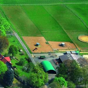
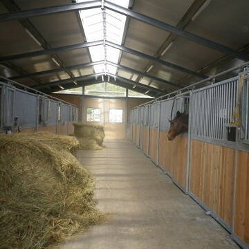
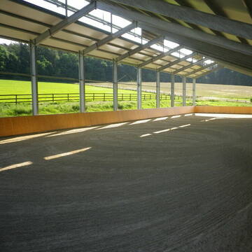
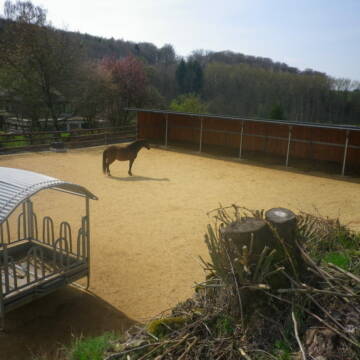
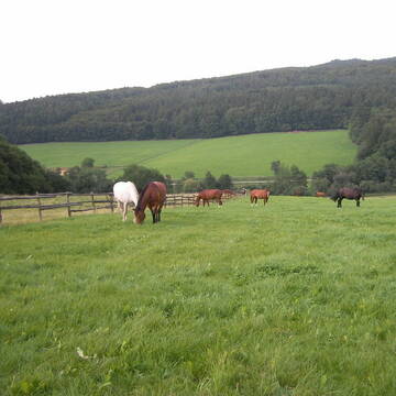
Vollpension Pferdebox mit großem Paddock Stall
Löhnberg
Gelbert
@MG_Sisters
Freizeitstall
Westernreiten
Vermieten
Verpachten
Führanlage
Hunde willkommen
Hufrehe geeignet
Pferdezucht
21 weitere...
P
Deprecated: Creation of dynamic property Zend_View_Helper_Ads::$adLink is deprecated in /var/www/stall-frei/htdocs/staging.stall-frei.de/library/Psf/View/Helper/Ads.php on line 108

Job gesucht?
Mechtersen
STALL-FREIde Marketing
@STALL-FREI-Marketing
Sie suchen einen Job und arbeiten gerne mit Pferden oder auf Reitanlagen?
Besuchen Sie jetzt unseren Stellenmarkt!
bjquarterhorses + Zucht + Aufzucht + Pension
Leun-Biskirchen
BJ Quarterhorses
@BJ-Quarterhorses
FN-Mitglied
Freizeitstall
Vermieten
Verpachten
Hunde willkommen
Krankenbox
Allergikerstall
Gnadenbrothof
32 weitere...
P

Reitanlage mit Herz und Individualität
Braunfels OT Tiefenbach
Reitanlage Tiefenbach
@Caro465
Freizeitstall
Pferdeausbildung
Vermieten
Hunde willkommen
Longierzirkel/Roundpen
Allergikerstall
Gnadenbrothof
18 weitere...
P

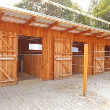
Offenstallplatz Innenbox Allergiker Vollversorgung
Selters
Hofgut-Hausen
@Hofgut-Hausen
Pferdeausbildung
Reitlehrer und -unterricht
Longierzirkel/Roundpen
Paddock
Allergikerstall
Außenbox mit Paddock
Offenstall
11 weitere...
S


Reha/-Rentnerplätze Hufrehe - Offenstallanlage
Waldbrunn
Christopher-Heun
@Christopher-Heun
FN-Mitglied
Freizeitstall
Vermieten
Hunde willkommen
Krankenbox
Allergikerstall
Gnadenbrothof
30 weitere...
P+
Leider kein Vorschaubild
Leider kein Vorschaubild
Pferdewirtschaftsmeister
Löhnberg
Pferdewirtschaftsmeister
@Pferdewirtschaftsmeister
FN-Mitglied
Freizeitstall
Vermieten
Hunde willkommen
Longierzirkel/Roundpen
Außenbox mit Paddock
Außenboxen
15 weitere...
B
Leider kein Vorschaubild
Leider kein Vorschaubild
Big Sky Ranch
Löhnberg
Big-Sky-Ranch
@Big-Sky-Ranch
Freizeitstall
Gastronomie
Paddock
Parkplatz für Pferdeanhänger
Außenbox mit Paddock
Außenboxen
Vollpension
19 weitere...
B


Box mit Vollpension und Weidegang
Elsoff
Familie Mücke
@Familie.Muecke
Freizeitstall
Pferdeausbildung
Vermieten
Krankenbox
Longierzirkel/Roundpen
Fohlenaufzucht möglich
Hufrehe geeignet
20 weitere...
P+

Reitanlage bei Familie Senckenberg
Groß-Gerau
Senckenberg
@Senckenberg
Freie Pferdeboxen auf dem Idyllischen Rheinfelderhof in Groß-Gerau
Leider kein Vorschaubild
Leider kein Vorschaubild
Aktivstall, Hengstaufzucht, Rentner, Abfohlservice
Weilburg
Sonnenhof Weilburg
@SonnenhofWeilburg
Freizeitstall
Pferdeausbildung
Krankenbox
Longierzirkel/Roundpen
Hengsthaltung möglich
Notfallboxen
Bewegungsstall
Laufstall
20 weitere...
B
Leider kein Vorschaubild
Leider kein Vorschaubild
Pferdeboxen zu vermieten
Weilburg - Odersbach
Christian-Wirth
@Christian-Wirth
Vermieten
Longierzirkel/Roundpen
Paddock
Außenbox mit Paddock
Innenbox
Selbstversorgung
9 weitere...
B
Deprecated: Creation of dynamic property Zend_View::$pageCount is deprecated in /var/www/stall-frei/htdocs/staging.stall-frei.de/library/vendor/shardj/zf1-future/library/Zend/View/Abstract.php on line 308
Deprecated: Creation of dynamic property Zend_View::$itemCountPerPage is deprecated in /var/www/stall-frei/htdocs/staging.stall-frei.de/library/vendor/shardj/zf1-future/library/Zend/View/Abstract.php on line 308
Deprecated: Creation of dynamic property Zend_View::$first is deprecated in /var/www/stall-frei/htdocs/staging.stall-frei.de/library/vendor/shardj/zf1-future/library/Zend/View/Abstract.php on line 308
Deprecated: Creation of dynamic property Zend_View::$current is deprecated in /var/www/stall-frei/htdocs/staging.stall-frei.de/library/vendor/shardj/zf1-future/library/Zend/View/Abstract.php on line 308
Deprecated: Creation of dynamic property Zend_View::$last is deprecated in /var/www/stall-frei/htdocs/staging.stall-frei.de/library/vendor/shardj/zf1-future/library/Zend/View/Abstract.php on line 308
Deprecated: Creation of dynamic property Zend_View::$next is deprecated in /var/www/stall-frei/htdocs/staging.stall-frei.de/library/vendor/shardj/zf1-future/library/Zend/View/Abstract.php on line 308
Deprecated: Creation of dynamic property Zend_View::$pagesInRange is deprecated in /var/www/stall-frei/htdocs/staging.stall-frei.de/library/vendor/shardj/zf1-future/library/Zend/View/Abstract.php on line 308
Deprecated: Creation of dynamic property Zend_View::$firstPageInRange is deprecated in /var/www/stall-frei/htdocs/staging.stall-frei.de/library/vendor/shardj/zf1-future/library/Zend/View/Abstract.php on line 308
Deprecated: Creation of dynamic property Zend_View::$lastPageInRange is deprecated in /var/www/stall-frei/htdocs/staging.stall-frei.de/library/vendor/shardj/zf1-future/library/Zend/View/Abstract.php on line 308
Deprecated: Creation of dynamic property Zend_View::$currentItemCount is deprecated in /var/www/stall-frei/htdocs/staging.stall-frei.de/library/vendor/shardj/zf1-future/library/Zend/View/Abstract.php on line 308
Deprecated: Creation of dynamic property Zend_View::$totalItemCount is deprecated in /var/www/stall-frei/htdocs/staging.stall-frei.de/library/vendor/shardj/zf1-future/library/Zend/View/Abstract.php on line 308
Deprecated: Creation of dynamic property Zend_View::$firstItemNumber is deprecated in /var/www/stall-frei/htdocs/staging.stall-frei.de/library/vendor/shardj/zf1-future/library/Zend/View/Abstract.php on line 308
Deprecated: Creation of dynamic property Zend_View::$lastItemNumber is deprecated in /var/www/stall-frei/htdocs/staging.stall-frei.de/library/vendor/shardj/zf1-future/library/Zend/View/Abstract.php on line 308
Deprecated: Creation of dynamic property Zend_View::$router is deprecated in /var/www/stall-frei/htdocs/staging.stall-frei.de/library/vendor/shardj/zf1-future/library/Zend/View/Abstract.php on line 308
Deprecated: Creation of dynamic property Zend_View::$urlParams is deprecated in /var/www/stall-frei/htdocs/staging.stall-frei.de/library/vendor/shardj/zf1-future/library/Zend/View/Abstract.php on line 308
Deprecated: Creation of dynamic property Zend_View::$showAds is deprecated in /var/www/stall-frei/htdocs/staging.stall-frei.de/library/vendor/shardj/zf1-future/library/Zend/View/Abstract.php on line 308
Deprecated: Creation of dynamic property Zend_View::$objectIds is deprecated in /var/www/stall-frei/htdocs/staging.stall-frei.de/library/vendor/shardj/zf1-future/library/Zend/View/Abstract.php on line 308
Deprecated: Creation of dynamic property Zend_View::$showNavbar is deprecated in /var/www/stall-frei/htdocs/staging.stall-frei.de/library/vendor/shardj/zf1-future/library/Zend/View/Abstract.php on line 308
Deprecated: Creation of dynamic property Zend_View::$showBreadcrumb is deprecated in /var/www/stall-frei/htdocs/staging.stall-frei.de/library/vendor/shardj/zf1-future/library/Zend/View/Abstract.php on line 308
Deprecated: Creation of dynamic property Zend_View::$showFooter is deprecated in /var/www/stall-frei/htdocs/staging.stall-frei.de/library/vendor/shardj/zf1-future/library/Zend/View/Abstract.php on line 308
Deprecated: Creation of dynamic property Zend_View::$showInternalAds is deprecated in /var/www/stall-frei/htdocs/staging.stall-frei.de/library/vendor/shardj/zf1-future/library/Zend/View/Abstract.php on line 308
Deprecated: Creation of dynamic property Zend_View::$blNoContent is deprecated in /var/www/stall-frei/htdocs/staging.stall-frei.de/library/vendor/shardj/zf1-future/library/Zend/View/Abstract.php on line 308
Deprecated: Creation of dynamic property Zend_View::$sMetaDesc is deprecated in /var/www/stall-frei/htdocs/staging.stall-frei.de/library/vendor/shardj/zf1-future/library/Zend/View/Abstract.php on line 308
Deprecated: Creation of dynamic property Zend_View::$useGmaps is deprecated in /var/www/stall-frei/htdocs/staging.stall-frei.de/library/vendor/shardj/zf1-future/library/Zend/View/Abstract.php on line 308
Deprecated: Creation of dynamic property Zend_View::$touches is deprecated in /var/www/stall-frei/htdocs/staging.stall-frei.de/library/vendor/shardj/zf1-future/library/Zend/View/Abstract.php on line 308
Deprecated: Creation of dynamic property Zend_View::$oProject is deprecated in /var/www/stall-frei/htdocs/staging.stall-frei.de/library/vendor/shardj/zf1-future/library/Zend/View/Abstract.php on line 308
Deprecated: Creation of dynamic property Zend_View::$pageHeadline is deprecated in /var/www/stall-frei/htdocs/staging.stall-frei.de/library/vendor/shardj/zf1-future/library/Zend/View/Abstract.php on line 308
Deprecated: Creation of dynamic property Zend_View::$disableLocationField is deprecated in /var/www/stall-frei/htdocs/staging.stall-frei.de/library/vendor/shardj/zf1-future/library/Zend/View/Abstract.php on line 308
Deprecated: Creation of dynamic property Zend_View::$isSearch is deprecated in /var/www/stall-frei/htdocs/staging.stall-frei.de/library/vendor/shardj/zf1-future/library/Zend/View/Abstract.php on line 308
Deprecated: Creation of dynamic property Zend_View::$pageTitle is deprecated in /var/www/stall-frei/htdocs/staging.stall-frei.de/library/vendor/shardj/zf1-future/library/Zend/View/Abstract.php on line 308
Deprecated: Creation of dynamic property Psf_Form_Element_Text::$class is deprecated in /var/www/stall-frei/htdocs/staging.stall-frei.de/library/vendor/shardj/zf1-future/library/Zend/Form/Element.php on line 874
Deprecated: Creation of dynamic property Psf_Form_Element_Text::$size is deprecated in /var/www/stall-frei/htdocs/staging.stall-frei.de/library/vendor/shardj/zf1-future/library/Zend/Form/Element.php on line 874
Deprecated: Creation of dynamic property Psf_Form_Element_Text::$placeholder is deprecated in /var/www/stall-frei/htdocs/staging.stall-frei.de/library/vendor/shardj/zf1-future/library/Zend/Form/Element.php on line 874
Deprecated: Creation of dynamic property Psf_Form_Element_Hidden::$class is deprecated in /var/www/stall-frei/htdocs/staging.stall-frei.de/library/vendor/shardj/zf1-future/library/Zend/Form/Element.php on line 874
Deprecated: Creation of dynamic property Psf_Form_Element_Hidden::$class is deprecated in /var/www/stall-frei/htdocs/staging.stall-frei.de/library/vendor/shardj/zf1-future/library/Zend/Form/Element.php on line 874
Deprecated: Creation of dynamic property Psf_Form_Element_Hidden::$class is deprecated in /var/www/stall-frei/htdocs/staging.stall-frei.de/library/vendor/shardj/zf1-future/library/Zend/Form/Element.php on line 874
Deprecated: Creation of dynamic property Psf_Form_Element_Hidden::$class is deprecated in /var/www/stall-frei/htdocs/staging.stall-frei.de/library/vendor/shardj/zf1-future/library/Zend/Form/Element.php on line 874
Deprecated: Creation of dynamic property Psf_Form_Element_Select::$class is deprecated in /var/www/stall-frei/htdocs/staging.stall-frei.de/library/vendor/shardj/zf1-future/library/Zend/Form/Element.php on line 874
Deprecated: Creation of dynamic property Psf_Form_Element_Select::$class is deprecated in /var/www/stall-frei/htdocs/staging.stall-frei.de/library/vendor/shardj/zf1-future/library/Zend/Form/Element.php on line 874
Deprecated: Creation of dynamic property Psf_Form_Element_Select::$class is deprecated in /var/www/stall-frei/htdocs/staging.stall-frei.de/library/vendor/shardj/zf1-future/library/Zend/Form/Element.php on line 874
Deprecated: Creation of dynamic property Psf_Form_Element_Select::$class is deprecated in /var/www/stall-frei/htdocs/staging.stall-frei.de/library/vendor/shardj/zf1-future/library/Zend/Form/Element.php on line 874
Deprecated: Creation of dynamic property Psf_Form_Element_Text::$class is deprecated in /var/www/stall-frei/htdocs/staging.stall-frei.de/library/vendor/shardj/zf1-future/library/Zend/Form/Element.php on line 874
Deprecated: Creation of dynamic property Psf_Form_Element_Checkbox::$label is deprecated in /var/www/stall-frei/htdocs/staging.stall-frei.de/library/vendor/shardj/zf1-future/library/Zend/Form/Element.php on line 874
Deprecated: Creation of dynamic property Zend_View::$sort is deprecated in /var/www/stall-frei/htdocs/staging.stall-frei.de/library/vendor/shardj/zf1-future/library/Zend/View/Abstract.php on line 308
Deprecated: Creation of dynamic property Zend_View::$searchLocation is deprecated in /var/www/stall-frei/htdocs/staging.stall-frei.de/library/vendor/shardj/zf1-future/library/Zend/View/Abstract.php on line 308
Deprecated: Creation of dynamic property Zend_View::$locationHint is deprecated in /var/www/stall-frei/htdocs/staging.stall-frei.de/library/vendor/shardj/zf1-future/library/Zend/View/Abstract.php on line 308
Psf_GeoCoder_Abstract::getLocation: Löhnberg Get Location CachedOrLive
Psf_GeoCoder_Abstract::getCachedOrLive: Löhnberg
Psf_GeoCoder_OpenCageData::makeApiRequest: response:
Array
(
[documentation] => https://opencagedata.com/api
[licenses] => Array
(
[0] => Array
(
[name] => see attribution guide
[url] => https://opencagedata.com/credits
)
)
[results] => Array
(
[0] => Array
(
[bounds] => Array
(
[northeast] => Array
(
[lat] => 50.5859368
[lng] => 8.3236188
)
[southwest] => Array
(
[lat] => 50.5012251
[lng] => 8.2052993
)
)
[components] => Array
(
[ISO_3166-1_alpha-2] => DE
[ISO_3166-1_alpha-3] => DEU
[ISO_3166-2] => Array
(
[0] => DE-HE
)
[_category] => place
[_normalized_city] => Löhnberg
[_type] => municipality
[continent] => Europe
[country] => Deutschland
[country_code] => de
[county] => Landkreis Limburg-Weilburg
[municipality] => Löhnberg
[political_union] => European Union
[postcode] => 35792
[state] => Hessen
[state_code] => HE
)
[confidence] => 7
[formatted] => 35792 Löhnberg, Deutschland
[geometry] => Array
(
[lat] => 50.5256362
[lng] => 8.2611178
)
)
[1] => Array
(
[bounds] => Array
(
[northeast] => Array
(
[lat] => 50.5327387
[lng] => 8.2886471
)
[southwest] => Array
(
[lat] => 50.5045446
[lng] => 8.2187602
)
)
[components] => Array
(
[ISO_3166-1_alpha-2] => DE
[ISO_3166-1_alpha-3] => DEU
[ISO_3166-2] => Array
(
[0] => DE-HE
)
[_category] => place
[_normalized_city] => Löhnberg
[_type] => village
[continent] => Europe
[country] => Deutschland
[country_code] => de
[county] => Landkreis Limburg-Weilburg
[municipality] => Löhnberg
[political_union] => European Union
[postcode] => 35792
[state] => Hessen
[state_code] => HE
[village] => Löhnberg
)
[confidence] => 7
[formatted] => 35792 Löhnberg, Deutschland
[geometry] => Array
(
[lat] => 50.5110877
[lng] => 8.2704446
)
)
[2] => Array
(
[bounds] => Array
(
[northeast] => Array
(
[lat] => 52.15748
[lng] => 8.201375
)
[southwest] => Array
(
[lat] => 52.15738
[lng] => 8.201275
)
)
[components] => Array
(
[ISO_3166-1_alpha-2] => DE
[ISO_3166-1_alpha-3] => DEU
[ISO_3166-2] => Array
(
[0] => DE-NI
)
[_category] => natural/water
[_normalized_city] => Hilter
[_type] => peak
[continent] => Europe
[country] => Deutschland
[country_code] => de
[county] => Landkreis Osnabrück
[municipality] => Hilter
[peak] => Lohnberg
[political_union] => European Union
[postcode] => 49201
[state] => Niedersachsen
[state_code] => NI
)
[confidence] => 9
[formatted] => Lohnberg, 49201 Hilter, Deutschland
[geometry] => Array
(
[lat] => 52.15743
[lng] => 8.201325
)
)
[3] => Array
(
[components] => Array
(
[ISO_3166-1_alpha-2] => FR
[ISO_3166-1_alpha-3] => FRA
[ISO_3166-2] => Array
(
[0] => FR-OCC
[1] => FR-81
)
[_category] => road
[_normalized_city] => Lombers
[_type] => road
[city] => Lombers
[continent] => Europe
[country] => France
[country_code] => fr
[county] => Tarn
[local_authority] => Communauté de communes du Centre Tarn
[political_union] => European Union
[postcode] => 81120
[road] => Route de Poulan
[state] => Occitanie
[state_code] => OCC
)
[confidence] => 2
[formatted] => Route de Poulan, 81120 Lombers, France
[geometry] => Array
(
[lat] => 43.835292
[lng] => 2.133389
)
)
[4] => Array
(
[components] => Array
(
[ISO_3166-1_alpha-2] => FR
[ISO_3166-1_alpha-3] => FRA
[ISO_3166-2] => Array
(
[0] => FR-OCC
[1] => FR-81
)
[_category] => road
[_normalized_city] => Réalmont
[_type] => road
[city] => Réalmont
[continent] => Europe
[country] => France
[country_code] => fr
[county] => Tarn
[local_authority] => Communauté de communes du Centre Tarn
[political_union] => European Union
[postcode] => 81120
[road] => Route de Lombers
[state] => Occitanie
[state_code] => OCC
)
[confidence] => 2
[formatted] => Route de Lombers, 81120 Réalmont, France
[geometry] => Array
(
[lat] => 43.789167
[lng] => 2.168962
)
)
[5] => Array
(
[components] => Array
(
[ISO_3166-1_alpha-2] => FR
[ISO_3166-1_alpha-3] => FRA
[ISO_3166-2] => Array
(
[0] => FR-GES
[1] => FR-6AE
[2] => FR-68
)
[_category] => place
[_normalized_city] => Orbey
[_type] => place
[city] => Orbey
[continent] => Europe
[country] => France
[country_code] => fr
[county] => Haut-Rhin
[local_authority] => Communauté de communes de la Vallée de Kaysersberg
[place] => la Lomberg
[political_union] => European Union
[postcode] => 68370
[state] => Grand Est
[state_code] => GES
)
[confidence] => 2
[formatted] => la Lomberg, 68370 Orbey, France
[geometry] => Array
(
[lat] => 48.091253
[lng] => 7.128403
)
)
[6] => Array
(
[components] => Array
(
[ISO_3166-1_alpha-2] => FR
[ISO_3166-1_alpha-3] => FRA
[ISO_3166-2] => Array
(
[0] => FR-OCC
[1] => FR-12
)
[_category] => road
[_normalized_city] => Rieupeyroux
[_type] => road
[city] => Rieupeyroux
[continent] => Europe
[country] => France
[country_code] => fr
[county] => Aveyron
[local_authority] => Communauté de communes Aveyron Bas Ségala Viaur
[political_union] => European Union
[postcode] => 12240
[road] => Route de Puech Lombert
[state] => Occitanie
[state_code] => OCC
)
[confidence] => 2
[formatted] => Route de Puech Lombert, 12240 Rieupeyroux, France
[geometry] => Array
(
[lat] => 44.285008
[lng] => 2.234993
)
)
[7] => Array
(
[components] => Array
(
[ISO_3166-1_alpha-2] => FR
[ISO_3166-1_alpha-3] => FRA
[ISO_3166-2] => Array
(
[0] => FR-OCC
[1] => FR-81
)
[_category] => road
[_normalized_city] => Poulan-Pouzols
[_type] => road
[city] => Poulan-Pouzols
[continent] => Europe
[country] => France
[country_code] => fr
[county] => Tarn
[local_authority] => Communauté de communes du Centre Tarn
[political_union] => European Union
[postcode] => 81120
[road] => Route de Lombers
[state] => Occitanie
[state_code] => OCC
)
[confidence] => 2
[formatted] => Route de Lombers, 81120 Poulan-Pouzols, France
[geometry] => Array
(
[lat] => 43.852886
[lng] => 2.096312
)
)
[8] => Array
(
[components] => Array
(
[ISO_3166-1_alpha-2] => FR
[ISO_3166-1_alpha-3] => FRA
[ISO_3166-2] => Array
(
[0] => FR-OCC
[1] => FR-81
)
[_category] => road
[_normalized_city] => Lombers
[_type] => road
[city] => Lombers
[continent] => Europe
[country] => France
[country_code] => fr
[county] => Tarn
[local_authority] => Communauté de communes du Centre Tarn
[political_union] => European Union
[postcode] => 81120
[road] => Chemin de La Durantié
[state] => Occitanie
[state_code] => OCC
)
[confidence] => 2
[formatted] => Chemin de La Durantié, 81120 Lombers, France
[geometry] => Array
(
[lat] => 43.825368
[lng] => 2.116836
)
)
[9] => Array
(
[components] => Array
(
[ISO_3166-1_alpha-2] => FR
[ISO_3166-1_alpha-3] => FRA
[ISO_3166-2] => Array
(
[0] => FR-ARA
[1] => FR-15
)
[_category] => road
[_normalized_city] => Naucelles
[_type] => road
[city] => Naucelles
[continent] => Europe
[country] => France
[country_code] => fr
[county] => Cantal
[local_authority] => Bassin d'Aurillac
[political_union] => European Union
[postcode] => 15250
[road] => Chemin de Lombert
[state] => Auvergne-Rhône-Alpes
[state_code] => ARA
)
[confidence] => 2
[formatted] => Chemin de Lombert, 15250 Naucelles, France
[geometry] => Array
(
[lat] => 44.958511
[lng] => 2.440784
)
)
)
[status] => Array
(
[code] => 200
[message] => OK
)
[stay_informed] => Array
(
[blog] => https://blog.opencagedata.com
[mastodon] => https://en.osm.town/@opencage
)
[thanks] => For using an OpenCage API
[timestamp] => Array
(
[created_http] => Sat, 07 Feb 2026 16:04:29 GMT
[created_unix] => 1770480269
)
[total_results] => 10
)
Psf_GeoCoder_Abstract::convertLocationResult
{"documentation":"https:\/\/opencagedata.com\/api","licenses":[{"name":"see attribution guide","url":"https:\/\/opencagedata.com\/credits"}],"results":[{"bounds":{"northeast":{"lat":50.5859368,"lng":8.3236188},"southwest":{"lat":50.5012251,"lng":8.2052993}},"components":{"ISO_3166-1_alpha-2":"DE","ISO_3166-1_alpha-3":"DEU","ISO_3166-2":["DE-HE"],"_category":"place","_normalized_city":"L\u00f6hnberg","_type":"municipality","continent":"Europe","country":"Deutschland","country_code":"de","county":"Landkreis Limburg-Weilburg","municipality":"L\u00f6hnberg","political_union":"European Union","postcode":"35792","state":"Hessen","state_code":"HE"},"confidence":7,"formatted":"35792 L\u00f6hnberg, Deutschland","geometry":{"lat":50.5256362,"lng":8.2611178}},{"bounds":{"northeast":{"lat":50.5327387,"lng":8.2886471},"southwest":{"lat":50.5045446,"lng":8.2187602}},"components":{"ISO_3166-1_alpha-2":"DE","ISO_3166-1_alpha-3":"DEU","ISO_3166-2":["DE-HE"],"_category":"place","_normalized_city":"L\u00f6hnberg","_type":"village","continent":"Europe","country":"Deutschland","country_code":"de","county":"Landkreis Limburg-Weilburg","municipality":"L\u00f6hnberg","political_union":"European Union","postcode":"35792","state":"Hessen","state_code":"HE","village":"L\u00f6hnberg"},"confidence":7,"formatted":"35792 L\u00f6hnberg, Deutschland","geometry":{"lat":50.5110877,"lng":8.2704446}},{"bounds":{"northeast":{"lat":52.15748,"lng":8.201375},"southwest":{"lat":52.15738,"lng":8.201275}},"components":{"ISO_3166-1_alpha-2":"DE","ISO_3166-1_alpha-3":"DEU","ISO_3166-2":["DE-NI"],"_category":"natural\/water","_normalized_city":"Hilter","_type":"peak","continent":"Europe","country":"Deutschland","country_code":"de","county":"Landkreis Osnabr\u00fcck","municipality":"Hilter","peak":"Lohnberg","political_union":"European Union","postcode":"49201","state":"Niedersachsen","state_code":"NI"},"confidence":9,"formatted":"Lohnberg, 49201 Hilter, Deutschland","geometry":{"lat":52.15743,"lng":8.201325}},{"components":{"ISO_3166-1_alpha-2":"FR","ISO_3166-1_alpha-3":"FRA","ISO_3166-2":["FR-OCC","FR-81"],"_category":"road","_normalized_city":"Lombers","_type":"road","city":"Lombers","continent":"Europe","country":"France","country_code":"fr","county":"Tarn","local_authority":"Communaut\u00e9 de communes du Centre Tarn","political_union":"European Union","postcode":"81120","road":"Route de Poulan","state":"Occitanie","state_code":"OCC"},"confidence":2,"formatted":"Route de Poulan, 81120 Lombers, France","geometry":{"lat":43.835292,"lng":2.133389}},{"components":{"ISO_3166-1_alpha-2":"FR","ISO_3166-1_alpha-3":"FRA","ISO_3166-2":["FR-OCC","FR-81"],"_category":"road","_normalized_city":"R\u00e9almont","_type":"road","city":"R\u00e9almont","continent":"Europe","country":"France","country_code":"fr","county":"Tarn","local_authority":"Communaut\u00e9 de communes du Centre Tarn","political_union":"European Union","postcode":"81120","road":"Route de Lombers","state":"Occitanie","state_code":"OCC"},"confidence":2,"formatted":"Route de Lombers, 81120 R\u00e9almont, France","geometry":{"lat":43.789167,"lng":2.168962}},{"components":{"ISO_3166-1_alpha-2":"FR","ISO_3166-1_alpha-3":"FRA","ISO_3166-2":["FR-GES","FR-6AE","FR-68"],"_category":"place","_normalized_city":"Orbey","_type":"place","city":"Orbey","continent":"Europe","country":"France","country_code":"fr","county":"Haut-Rhin","local_authority":"Communaut\u00e9 de communes de la Vall\u00e9e de Kaysersberg","place":"la Lomberg","political_union":"European Union","postcode":"68370","state":"Grand Est","state_code":"GES"},"confidence":2,"formatted":"la Lomberg, 68370 Orbey, France","geometry":{"lat":48.091253,"lng":7.128403}},{"components":{"ISO_3166-1_alpha-2":"FR","ISO_3166-1_alpha-3":"FRA","ISO_3166-2":["FR-OCC","FR-12"],"_category":"road","_normalized_city":"Rieupeyroux","_type":"road","city":"Rieupeyroux","continent":"Europe","country":"France","country_code":"fr","county":"Aveyron","local_authority":"Communaut\u00e9 de communes Aveyron Bas S\u00e9gala Viaur","political_union":"European Union","postcode":"12240","road":"Route de Puech Lombert","state":"Occitanie","state_code":"OCC"},"confidence":2,"formatted":"Route de Puech Lombert, 12240 Rieupeyroux, France","geometry":{"lat":44.285008,"lng":2.234993}},{"components":{"ISO_3166-1_alpha-2":"FR","ISO_3166-1_alpha-3":"FRA","ISO_3166-2":["FR-OCC","FR-81"],"_category":"road","_normalized_city":"Poulan-Pouzols","_type":"road","city":"Poulan-Pouzols","continent":"Europe","country":"France","country_code":"fr","county":"Tarn","local_authority":"Communaut\u00e9 de communes du Centre Tarn","political_union":"European Union","postcode":"81120","road":"Route de Lombers","state":"Occitanie","state_code":"OCC"},"confidence":2,"formatted":"Route de Lombers, 81120 Poulan-Pouzols, France","geometry":{"lat":43.852886,"lng":2.096312}},{"components":{"ISO_3166-1_alpha-2":"FR","ISO_3166-1_alpha-3":"FRA","ISO_3166-2":["FR-OCC","FR-81"],"_category":"road","_normalized_city":"Lombers","_type":"road","city":"Lombers","continent":"Europe","country":"France","country_code":"fr","county":"Tarn","local_authority":"Communaut\u00e9 de communes du Centre Tarn","political_union":"European Union","postcode":"81120","road":"Chemin de La Duranti\u00e9","state":"Occitanie","state_code":"OCC"},"confidence":2,"formatted":"Chemin de La Duranti\u00e9, 81120 Lombers, France","geometry":{"lat":43.825368,"lng":2.116836}},{"components":{"ISO_3166-1_alpha-2":"FR","ISO_3166-1_alpha-3":"FRA","ISO_3166-2":["FR-ARA","FR-15"],"_category":"road","_normalized_city":"Naucelles","_type":"road","city":"Naucelles","continent":"Europe","country":"France","country_code":"fr","county":"Cantal","local_authority":"Bassin d'Aurillac","political_union":"European Union","postcode":"15250","road":"Chemin de Lombert","state":"Auvergne-Rh\u00f4ne-Alpes","state_code":"ARA"},"confidence":2,"formatted":"Chemin de Lombert, 15250 Naucelles, France","geometry":{"lat":44.958511,"lng":2.440784}}],"status":{"code":200,"message":"OK"},"stay_informed":{"blog":"https:\/\/blog.opencagedata.com","mastodon":"https:\/\/en.osm.town\/@opencage"},"thanks":"For using an OpenCage API","timestamp":{"created_http":"Sat, 07 Feb 2026 16:04:29 GMT","created_unix":1770480269},"total_results":10}Array
(
[0] => stdClass Object
(
[bounds] => stdClass Object
(
[northeast] => stdClass Object
(
[lat] => 50.5859368
[lng] => 8.3236188
)
[southwest] => stdClass Object
(
[lat] => 50.5012251
[lng] => 8.2052993
)
)
[components] => stdClass Object
(
[ISO_3166-1_alpha-2] => DE
[ISO_3166-1_alpha-3] => DEU
[ISO_3166-2] => Array
(
[0] => DE-HE
)
[_category] => place
[_normalized_city] => Löhnberg
[_type] => municipality
[continent] => Europe
[country] => Deutschland
[country_code] => de
[county] => Landkreis Limburg-Weilburg
[municipality] => Löhnberg
[political_union] => European Union
[postcode] => 35792
[state] => Hessen
[state_code] => HE
)
[confidence] => 7
[formatted] => 35792 Löhnberg, Deutschland
[geometry] => stdClass Object
(
[lat] => 50.5256362
[lng] => 8.2611178
)
)
[1] => stdClass Object
(
[bounds] => stdClass Object
(
[northeast] => stdClass Object
(
[lat] => 50.5327387
[lng] => 8.2886471
)
[southwest] => stdClass Object
(
[lat] => 50.5045446
[lng] => 8.2187602
)
)
[components] => stdClass Object
(
[ISO_3166-1_alpha-2] => DE
[ISO_3166-1_alpha-3] => DEU
[ISO_3166-2] => Array
(
[0] => DE-HE
)
[_category] => place
[_normalized_city] => Löhnberg
[_type] => village
[continent] => Europe
[country] => Deutschland
[country_code] => de
[county] => Landkreis Limburg-Weilburg
[municipality] => Löhnberg
[political_union] => European Union
[postcode] => 35792
[state] => Hessen
[state_code] => HE
[village] => Löhnberg
)
[confidence] => 7
[formatted] => 35792 Löhnberg, Deutschland
[geometry] => stdClass Object
(
[lat] => 50.5110877
[lng] => 8.2704446
)
)
[2] => stdClass Object
(
[bounds] => stdClass Object
(
[northeast] => stdClass Object
(
[lat] => 52.15748
[lng] => 8.201375
)
[southwest] => stdClass Object
(
[lat] => 52.15738
[lng] => 8.201275
)
)
[components] => stdClass Object
(
[ISO_3166-1_alpha-2] => DE
[ISO_3166-1_alpha-3] => DEU
[ISO_3166-2] => Array
(
[0] => DE-NI
)
[_category] => natural/water
[_normalized_city] => Hilter
[_type] => peak
[continent] => Europe
[country] => Deutschland
[country_code] => de
[county] => Landkreis Osnabrück
[municipality] => Hilter
[peak] => Lohnberg
[political_union] => European Union
[postcode] => 49201
[state] => Niedersachsen
[state_code] => NI
)
[confidence] => 9
[formatted] => Lohnberg, 49201 Hilter, Deutschland
[geometry] => stdClass Object
(
[lat] => 52.15743
[lng] => 8.201325
)
)
[3] => stdClass Object
(
[components] => stdClass Object
(
[ISO_3166-1_alpha-2] => FR
[ISO_3166-1_alpha-3] => FRA
[ISO_3166-2] => Array
(
[0] => FR-OCC
[1] => FR-81
)
[_category] => road
[_normalized_city] => Lombers
[_type] => road
[city] => Lombers
[continent] => Europe
[country] => France
[country_code] => fr
[county] => Tarn
[local_authority] => Communauté de communes du Centre Tarn
[political_union] => European Union
[postcode] => 81120
[road] => Route de Poulan
[state] => Occitanie
[state_code] => OCC
)
[confidence] => 2
[formatted] => Route de Poulan, 81120 Lombers, France
[geometry] => stdClass Object
(
[lat] => 43.835292
[lng] => 2.133389
)
)
[4] => stdClass Object
(
[components] => stdClass Object
(
[ISO_3166-1_alpha-2] => FR
[ISO_3166-1_alpha-3] => FRA
[ISO_3166-2] => Array
(
[0] => FR-OCC
[1] => FR-81
)
[_category] => road
[_normalized_city] => Réalmont
[_type] => road
[city] => Réalmont
[continent] => Europe
[country] => France
[country_code] => fr
[county] => Tarn
[local_authority] => Communauté de communes du Centre Tarn
[political_union] => European Union
[postcode] => 81120
[road] => Route de Lombers
[state] => Occitanie
[state_code] => OCC
)
[confidence] => 2
[formatted] => Route de Lombers, 81120 Réalmont, France
[geometry] => stdClass Object
(
[lat] => 43.789167
[lng] => 2.168962
)
)
[5] => stdClass Object
(
[components] => stdClass Object
(
[ISO_3166-1_alpha-2] => FR
[ISO_3166-1_alpha-3] => FRA
[ISO_3166-2] => Array
(
[0] => FR-GES
[1] => FR-6AE
[2] => FR-68
)
[_category] => place
[_normalized_city] => Orbey
[_type] => place
[city] => Orbey
[continent] => Europe
[country] => France
[country_code] => fr
[county] => Haut-Rhin
[local_authority] => Communauté de communes de la Vallée de Kaysersberg
[place] => la Lomberg
[political_union] => European Union
[postcode] => 68370
[state] => Grand Est
[state_code] => GES
)
[confidence] => 2
[formatted] => la Lomberg, 68370 Orbey, France
[geometry] => stdClass Object
(
[lat] => 48.091253
[lng] => 7.128403
)
)
[6] => stdClass Object
(
[components] => stdClass Object
(
[ISO_3166-1_alpha-2] => FR
[ISO_3166-1_alpha-3] => FRA
[ISO_3166-2] => Array
(
[0] => FR-OCC
[1] => FR-12
)
[_category] => road
[_normalized_city] => Rieupeyroux
[_type] => road
[city] => Rieupeyroux
[continent] => Europe
[country] => France
[country_code] => fr
[county] => Aveyron
[local_authority] => Communauté de communes Aveyron Bas Ségala Viaur
[political_union] => European Union
[postcode] => 12240
[road] => Route de Puech Lombert
[state] => Occitanie
[state_code] => OCC
)
[confidence] => 2
[formatted] => Route de Puech Lombert, 12240 Rieupeyroux, France
[geometry] => stdClass Object
(
[lat] => 44.285008
[lng] => 2.234993
)
)
[7] => stdClass Object
(
[components] => stdClass Object
(
[ISO_3166-1_alpha-2] => FR
[ISO_3166-1_alpha-3] => FRA
[ISO_3166-2] => Array
(
[0] => FR-OCC
[1] => FR-81
)
[_category] => road
[_normalized_city] => Poulan-Pouzols
[_type] => road
[city] => Poulan-Pouzols
[continent] => Europe
[country] => France
[country_code] => fr
[county] => Tarn
[local_authority] => Communauté de communes du Centre Tarn
[political_union] => European Union
[postcode] => 81120
[road] => Route de Lombers
[state] => Occitanie
[state_code] => OCC
)
[confidence] => 2
[formatted] => Route de Lombers, 81120 Poulan-Pouzols, France
[geometry] => stdClass Object
(
[lat] => 43.852886
[lng] => 2.096312
)
)
[8] => stdClass Object
(
[components] => stdClass Object
(
[ISO_3166-1_alpha-2] => FR
[ISO_3166-1_alpha-3] => FRA
[ISO_3166-2] => Array
(
[0] => FR-OCC
[1] => FR-81
)
[_category] => road
[_normalized_city] => Lombers
[_type] => road
[city] => Lombers
[continent] => Europe
[country] => France
[country_code] => fr
[county] => Tarn
[local_authority] => Communauté de communes du Centre Tarn
[political_union] => European Union
[postcode] => 81120
[road] => Chemin de La Durantié
[state] => Occitanie
[state_code] => OCC
)
[confidence] => 2
[formatted] => Chemin de La Durantié, 81120 Lombers, France
[geometry] => stdClass Object
(
[lat] => 43.825368
[lng] => 2.116836
)
)
[9] => stdClass Object
(
[components] => stdClass Object
(
[ISO_3166-1_alpha-2] => FR
[ISO_3166-1_alpha-3] => FRA
[ISO_3166-2] => Array
(
[0] => FR-ARA
[1] => FR-15
)
[_category] => road
[_normalized_city] => Naucelles
[_type] => road
[city] => Naucelles
[continent] => Europe
[country] => France
[country_code] => fr
[county] => Cantal
[local_authority] => Bassin d'Aurillac
[political_union] => European Union
[postcode] => 15250
[road] => Chemin de Lombert
[state] => Auvergne-Rhône-Alpes
[state_code] => ARA
)
[confidence] => 2
[formatted] => Chemin de Lombert, 15250 Naucelles, France
[geometry] => stdClass Object
(
[lat] => 44.958511
[lng] => 2.440784
)
)
)
Psf_GeoCoder_OpenCageData::getKeyMap: 0
stdClass Object
(
    [bounds] => stdClass Object
        (
            [northeast] => stdClass Object
                (
                    [lat] => 50.5859368
                    [lng] => 8.3236188
                )

            [southwest] => stdClass Object
                (
                    [lat] => 50.5012251
                    [lng] => 8.2052993
                )

        )

    [components] => stdClass Object
        (
            [ISO_3166-1_alpha-2] => DE
            [ISO_3166-1_alpha-3] => DEU
            [ISO_3166-2] => Array
                (
                    [0] => DE-HE
                )

            [_category] => place
            [_normalized_city] => Löhnberg
            [_type] => municipality
            [continent] => Europe
            [country] => Deutschland
            [country_code] => de
            [county] => Landkreis Limburg-Weilburg
            [municipality] => Löhnberg
            [political_union] => European Union
            [postcode] => 35792
            [state] => Hessen
            [state_code] => HE
        )

    [confidence] => 7
    [formatted] => 35792 Löhnberg, Deutschland
    [geometry] => stdClass Object
        (
            [lat] => 50.5256362
            [lng] => 8.2611178
        )

)
Psf_GeoCoder_OpenCageData::getCounty: Limburg-Weilburg
Psf_GeoCoder_OpenCageData::addMissingData REFETCH!
Array
(
    [address] => 35792 Löhnberg, Deutschland
    [type] => municipality
    [street] =>
    [city] =>
    [county] => Limburg-Weilburg
    [state] => Hessen
    [zip] => 35792
    [country] => Deutschland
    [suburb] =>
    [countrycode] => de
    [latitude] => 50.5256362
    [longitude] => 8.2611178
    [accuracy] => 1
    [confidence] => 7
    [bounds] => stdClass Object
        (
            [northeast] => stdClass Object
                (
                    [lat] => 50.5859368
                    [lng] => 8.3236188
                )

            [southwest] => stdClass Object
                (
                    [lat] => 50.5012251
                    [lng] => 8.2052993
                )

        )

)
reformat!
Array
(
    [address] => 35792 Löhnberg, Deutschland
    [type] => municipality
    [street] =>
    [city] =>
    [county] => Limburg-Weilburg
    [state] => Hessen
    [zip] => 35792
    [country] => Deutschland
    [suburb] =>
    [countrycode] => de
    [latitude] => 50.5256362
    [longitude] => 8.2611178
    [accuracy] => 1
    [confidence] => 7
    [bounds] => stdClass Object
        (
            [northeast] => stdClass Object
                (
                    [lat] => 50.5859368
                    [lng] => 8.3236188
                )

            [southwest] => stdClass Object
                (
                    [lat] => 50.5012251
                    [lng] => 8.2052993
                )

        )

    [place] => 35792 , Hessen
    [hash] => 44a5e4ef0c08d89a5c8655e3850be43e
)
Psf_GeoCoder_OpenCageData::getKeyMap: 1
stdClass Object
(
    [bounds] => stdClass Object
        (
            [northeast] => stdClass Object
                (
                    [lat] => 50.5327387
                    [lng] => 8.2886471
                )

            [southwest] => stdClass Object
                (
                    [lat] => 50.5045446
                    [lng] => 8.2187602
                )

        )

    [components] => stdClass Object
        (
            [ISO_3166-1_alpha-2] => DE
            [ISO_3166-1_alpha-3] => DEU
            [ISO_3166-2] => Array
                (
                    [0] => DE-HE
                )

            [_category] => place
            [_normalized_city] => Löhnberg
            [_type] => village
            [continent] => Europe
            [country] => Deutschland
            [country_code] => de
            [county] => Landkreis Limburg-Weilburg
            [municipality] => Löhnberg
            [political_union] => European Union
            [postcode] => 35792
            [state] => Hessen
            [state_code] => HE
            [village] => Löhnberg
        )

    [confidence] => 7
    [formatted] => 35792 Löhnberg, Deutschland
    [geometry] => stdClass Object
        (
            [lat] => 50.5110877
            [lng] => 8.2704446
        )

)
Psf_GeoCoder_OpenCageData::getCounty: Limburg-Weilburg
Psf_GeoCoder_OpenCageData::addMissingData REFETCH!
Array
(
    [address] => 35792 Löhnberg, Deutschland
    [type] => village
    [street] =>
    [city] => Löhnberg
    [county] => Limburg-Weilburg
    [state] => Hessen
    [zip] => 35792
    [country] => Deutschland
    [suburb] =>
    [countrycode] => de
    [latitude] => 50.5110877
    [longitude] => 8.2704446
    [accuracy] => 1
    [confidence] => 7
    [bounds] => stdClass Object
        (
            [northeast] => stdClass Object
                (
                    [lat] => 50.5327387
                    [lng] => 8.2886471
                )

            [southwest] => stdClass Object
                (
                    [lat] => 50.5045446
                    [lng] => 8.2187602
                )

        )

)
reformat!
Array
(
    [address] => 35792 Löhnberg, Deutschland
    [type] => village
    [street] =>
    [city] => Löhnberg
    [county] => Limburg-Weilburg
    [state] => Hessen
    [zip] => 35792
    [country] => Deutschland
    [suburb] =>
    [countrycode] => de
    [latitude] => 50.5110877
    [longitude] => 8.2704446
    [accuracy] => 1
    [confidence] => 7
    [bounds] => stdClass Object
        (
            [northeast] => stdClass Object
                (
                    [lat] => 50.5327387
                    [lng] => 8.2886471
                )

            [southwest] => stdClass Object
                (
                    [lat] => 50.5045446
                    [lng] => 8.2187602
                )

        )

    [place] => 35792 Löhnberg, Hessen
    [hash] => 65b27bf2d522315d5528ce0b240b3c4d
)
Psf_GeoCoder_OpenCageData::getKeyMap: 2
stdClass Object
(
    [bounds] => stdClass Object
        (
            [northeast] => stdClass Object
                (
                    [lat] => 52.15748
                    [lng] => 8.201375
                )

            [southwest] => stdClass Object
                (
                    [lat] => 52.15738
                    [lng] => 8.201275
                )

        )

    [components] => stdClass Object
        (
            [ISO_3166-1_alpha-2] => DE
            [ISO_3166-1_alpha-3] => DEU
            [ISO_3166-2] => Array
                (
                    [0] => DE-NI
                )

            [_category] => natural/water
            [_normalized_city] => Hilter
            [_type] => peak
            [continent] => Europe
            [country] => Deutschland
            [country_code] => de
            [county] => Landkreis Osnabrück
            [municipality] => Hilter
            [peak] => Lohnberg
            [political_union] => European Union
            [postcode] => 49201
            [state] => Niedersachsen
            [state_code] => NI
        )

    [confidence] => 9
    [formatted] => Lohnberg, 49201 Hilter, Deutschland
    [geometry] => stdClass Object
        (
            [lat] => 52.15743
            [lng] => 8.201325
        )

)
Psf_GeoCoder_OpenCageData::getCounty: Osnabrück
Psf_GeoCoder_OpenCageData::addMissingData REFETCH!
Array
(
    [address] => Lohnberg, 49201 Hilter, Deutschland
    [type] => peak
    [street] =>
    [city] =>
    [county] => Osnabrück
    [state] => Niedersachsen
    [zip] => 49201
    [country] => Deutschland
    [suburb] =>
    [countrycode] => de
    [latitude] => 52.15743
    [longitude] => 8.201325
    [accuracy] => 1
    [confidence] => 9
    [bounds] => stdClass Object
        (
            [northeast] => stdClass Object
                (
                    [lat] => 52.15748
                    [lng] => 8.201375
                )

            [southwest] => stdClass Object
                (
                    [lat] => 52.15738
                    [lng] => 8.201275
                )

        )

)
reformat!
Array
(
    [address] => Lohnberg, 49201 Hilter, Deutschland
    [type] => peak
    [street] =>
    [city] =>
    [county] => Osnabrück
    [state] => Niedersachsen
    [zip] => 49201
    [country] => Deutschland
    [suburb] =>
    [countrycode] => de
    [latitude] => 52.15743
    [longitude] => 8.201325
    [accuracy] => 1
    [confidence] => 9
    [bounds] => stdClass Object
        (
            [northeast] => stdClass Object
                (
                    [lat] => 52.15748
                    [lng] => 8.201375
                )

            [southwest] => stdClass Object
                (
                    [lat] => 52.15738
                    [lng] => 8.201275
                )

        )

    [place] => 49201 , Niedersachsen
    [hash] => 38d8bd824206daae4dd346dd0356e8c6
)
Psf_GeoCoder_OpenCageData::getKeyMap: 3
stdClass Object
(
    [components] => stdClass Object
        (
            [ISO_3166-1_alpha-2] => FR
            [ISO_3166-1_alpha-3] => FRA
            [ISO_3166-2] => Array
                (
                    [0] => FR-OCC
                    [1] => FR-81
                )

            [_category] => road
            [_normalized_city] => Lombers
            [_type] => road
            [city] => Lombers
            [continent] => Europe
            [country] => France
            [country_code] => fr
            [county] => Tarn
            [local_authority] => Communauté de communes du Centre Tarn
            [political_union] => European Union
            [postcode] => 81120
            [road] => Route de Poulan
            [state] => Occitanie
            [state_code] => OCC
        )

    [confidence] => 2
    [formatted] => Route de Poulan, 81120 Lombers, France
    [geometry] => stdClass Object
        (
            [lat] => 43.835292
            [lng] => 2.133389
        )

)
Psf_GeoCoder_OpenCageData::getCounty: Tarn
Psf_GeoCoder_OpenCageData::addMissingData REFETCH!
Array
(
    [address] => Route de Poulan, 81120 Lombers, France
    [type] => road
    [street] => Route de Poulan
    [city] => Lombers
    [county] => Tarn
    [state] => Occitanie
    [zip] => 81120
    [country] => France
    [suburb] =>
    [countrycode] => fr
    [latitude] => 43.835292
    [longitude] => 2.133389
    [accuracy] => 1
    [confidence] => 2
    [bounds] =>
)
reformat!
Array
(
    [address] => Route de Poulan, 81120 Lombers, France
    [type] => road
    [street] => Route de Poulan
    [city] => Lombers
    [county] => Tarn
    [state] => Occitanie
    [zip] => 81120
    [country] => France
    [suburb] =>
    [countrycode] => fr
    [latitude] => 43.835292
    [longitude] => 2.133389
    [accuracy] => 1
    [confidence] => 2
    [bounds] =>
    [place] => Route de Poulan, 81120 Lombers, Occitanie
    [hash] => f0254de9586455a6966cc81d8440b246
)
Psf_GeoCoder_OpenCageData::getKeyMap: 4
stdClass Object
(
    [components] => stdClass Object
        (
            [ISO_3166-1_alpha-2] => FR
            [ISO_3166-1_alpha-3] => FRA
            [ISO_3166-2] => Array
                (
                    [0] => FR-OCC
                    [1] => FR-81
                )

            [_category] => road
            [_normalized_city] => Réalmont
            [_type] => road
            [city] => Réalmont
            [continent] => Europe
            [country] => France
            [country_code] => fr
            [county] => Tarn
            [local_authority] => Communauté de communes du Centre Tarn
            [political_union] => European Union
            [postcode] => 81120
            [road] => Route de Lombers
            [state] => Occitanie
            [state_code] => OCC
        )

    [confidence] => 2
    [formatted] => Route de Lombers, 81120 Réalmont, France
    [geometry] => stdClass Object
        (
            [lat] => 43.789167
            [lng] => 2.168962
        )

)
Psf_GeoCoder_OpenCageData::getCounty: Tarn
Psf_GeoCoder_OpenCageData::addMissingData REFETCH!
Array
(
    [address] => Route de Lombers, 81120 Réalmont, France
    [type] => road
    [street] => Route de Lombers
    [city] => Réalmont
    [county] => Tarn
    [state] => Occitanie
    [zip] => 81120
    [country] => France
    [suburb] =>
    [countrycode] => fr
    [latitude] => 43.789167
    [longitude] => 2.168962
    [accuracy] => 1
    [confidence] => 2
    [bounds] =>
)
reformat!
Array
(
    [address] => Route de Lombers, 81120 Réalmont, France
    [type] => road
    [street] => Route de Lombers
    [city] => Réalmont
    [county] => Tarn
    [state] => Occitanie
    [zip] => 81120
    [country] => France
    [suburb] =>
    [countrycode] => fr
    [latitude] => 43.789167
    [longitude] => 2.168962
    [accuracy] => 1
    [confidence] => 2
    [bounds] =>
    [place] => Route de Lombers, 81120 Réalmont, Occitanie
    [hash] => a74942c58223dbdadc67d7abf1011721
)
Psf_GeoCoder_OpenCageData::getKeyMap: 5
stdClass Object
(
    [components] => stdClass Object
        (
            [ISO_3166-1_alpha-2] => FR
            [ISO_3166-1_alpha-3] => FRA
            [ISO_3166-2] => Array
                (
                    [0] => FR-GES
                    [1] => FR-6AE
                    [2] => FR-68
                )

            [_category] => place
            [_normalized_city] => Orbey
            [_type] => place
            [city] => Orbey
            [continent] => Europe
            [country] => France
            [country_code] => fr
            [county] => Haut-Rhin
            [local_authority] => Communauté de communes de la Vallée de Kaysersberg
            [place] => la Lomberg
            [political_union] => European Union
            [postcode] => 68370
            [state] => Grand Est
            [state_code] => GES
        )

    [confidence] => 2
    [formatted] => la Lomberg, 68370 Orbey, France
    [geometry] => stdClass Object
        (
            [lat] => 48.091253
            [lng] => 7.128403
        )

)
Psf_GeoCoder_OpenCageData::getCounty: Haut-Rhin
Psf_GeoCoder_OpenCageData::addMissingData REFETCH!
Array
(
    [address] => la Lomberg, 68370 Orbey, France
    [type] => place
    [street] =>
    [city] => Orbey
    [county] => Haut-Rhin
    [state] => Grand Est
    [zip] => 68370
    [country] => France
    [suburb] =>
    [countrycode] => fr
    [latitude] => 48.091253
    [longitude] => 7.128403
    [accuracy] => 1
    [confidence] => 2
    [bounds] =>
)
reformat!
Array
(
    [address] => la Lomberg, 68370 Orbey, France
    [type] => place
    [street] =>
    [city] => Orbey
    [county] => Haut-Rhin
    [state] => Grand Est
    [zip] => 68370
    [country] => France
    [suburb] =>
    [countrycode] => fr
    [latitude] => 48.091253
    [longitude] => 7.128403
    [accuracy] => 1
    [confidence] => 2
    [bounds] =>
    [place] => 68370 Orbey, Grand Est
    [hash] => e77332686912d686e31d8b379373836c
)
Psf_GeoCoder_OpenCageData::getKeyMap: 6
stdClass Object
(
    [components] => stdClass Object
        (
            [ISO_3166-1_alpha-2] => FR
            [ISO_3166-1_alpha-3] => FRA
            [ISO_3166-2] => Array
                (
                    [0] => FR-OCC
                    [1] => FR-12
                )

            [_category] => road
            [_normalized_city] => Rieupeyroux
            [_type] => road
            [city] => Rieupeyroux
            [continent] => Europe
            [country] => France
            [country_code] => fr
            [county] => Aveyron
            [local_authority] => Communauté de communes Aveyron Bas Ségala Viaur
            [political_union] => European Union
            [postcode] => 12240
            [road] => Route de Puech Lombert
            [state] => Occitanie
            [state_code] => OCC
        )

    [confidence] => 2
    [formatted] => Route de Puech Lombert, 12240 Rieupeyroux, France
    [geometry] => stdClass Object
        (
            [lat] => 44.285008
            [lng] => 2.234993
        )

)
Psf_GeoCoder_OpenCageData::getCounty: Aveyron
Psf_GeoCoder_OpenCageData::addMissingData REFETCH!
Array
(
    [address] => Route de Puech Lombert, 12240 Rieupeyroux, France
    [type] => road
    [street] => Route de Puech Lombert
    [city] => Rieupeyroux
    [county] => Aveyron
    [state] => Occitanie
    [zip] => 12240
    [country] => France
    [suburb] =>
    [countrycode] => fr
    [latitude] => 44.285008
    [longitude] => 2.234993
    [accuracy] => 1
    [confidence] => 2
    [bounds] =>
)
reformat!
Array
(
    [address] => Route de Puech Lombert, 12240 Rieupeyroux, France
    [type] => road
    [street] => Route de Puech Lombert
    [city] => Rieupeyroux
    [county] => Aveyron
    [state] => Occitanie
    [zip] => 12240
    [country] => France
    [suburb] =>
    [countrycode] => fr
    [latitude] => 44.285008
    [longitude] => 2.234993
    [accuracy] => 1
    [confidence] => 2
    [bounds] =>
    [place] => Route de Puech Lombert, 12240 Rieupeyroux, Occitanie
    [hash] => 2bac014ac5c35dfff20b352049616543
)
Psf_GeoCoder_OpenCageData::getKeyMap: 7
stdClass Object
(
    [components] => stdClass Object
        (
            [ISO_3166-1_alpha-2] => FR
            [ISO_3166-1_alpha-3] => FRA
            [ISO_3166-2] => Array
                (
                    [0] => FR-OCC
                    [1] => FR-81
                )

            [_category] => road
            [_normalized_city] => Poulan-Pouzols
            [_type] => road
            [city] => Poulan-Pouzols
            [continent] => Europe
            [country] => France
            [country_code] => fr
            [county] => Tarn
            [local_authority] => Communauté de communes du Centre Tarn
            [political_union] => European Union
            [postcode] => 81120
            [road] => Route de Lombers
            [state] => Occitanie
            [state_code] => OCC
        )

    [confidence] => 2
    [formatted] => Route de Lombers, 81120 Poulan-Pouzols, France
    [geometry] => stdClass Object
        (
            [lat] => 43.852886
            [lng] => 2.096312
        )

)
Psf_GeoCoder_OpenCageData::getCounty: Tarn
Psf_GeoCoder_OpenCageData::addMissingData REFETCH!
Array
(
    [address] => Route de Lombers, 81120 Poulan-Pouzols, France
    [type] => road
    [street] => Route de Lombers
    [city] => Poulan-Pouzols
    [county] => Tarn
    [state] => Occitanie
    [zip] => 81120
    [country] => France
    [suburb] =>
    [countrycode] => fr
    [latitude] => 43.852886
    [longitude] => 2.096312
    [accuracy] => 1
    [confidence] => 2
    [bounds] =>
)
reformat!
Array
(
    [address] => Route de Lombers, 81120 Poulan-Pouzols, France
    [type] => road
    [street] => Route de Lombers
    [city] => Poulan-Pouzols
    [county] => Tarn
    [state] => Occitanie
    [zip] => 81120
    [country] => France
    [suburb] =>
    [countrycode] => fr
    [latitude] => 43.852886
    [longitude] => 2.096312
    [accuracy] => 1
    [confidence] => 2
    [bounds] =>
    [place] => Route de Lombers, 81120 Poulan-Pouzols, Occitanie
    [hash] => d9418128473b04889f643cc135260019
)
Psf_GeoCoder_OpenCageData::getKeyMap: 8
stdClass Object
(
    [components] => stdClass Object
        (
            [ISO_3166-1_alpha-2] => FR
            [ISO_3166-1_alpha-3] => FRA
            [ISO_3166-2] => Array
                (
                    [0] => FR-OCC
                    [1] => FR-81
                )

            [_category] => road
            [_normalized_city] => Lombers
            [_type] => road
            [city] => Lombers
            [continent] => Europe
            [country] => France
            [country_code] => fr
            [county] => Tarn
            [local_authority] => Communauté de communes du Centre Tarn
            [political_union] => European Union
            [postcode] => 81120
            [road] => Chemin de La Durantié
            [state] => Occitanie
            [state_code] => OCC
        )

    [confidence] => 2
    [formatted] => Chemin de La Durantié, 81120 Lombers, France
    [geometry] => stdClass Object
        (
            [lat] => 43.825368
            [lng] => 2.116836
        )

)
Psf_GeoCoder_OpenCageData::getCounty: Tarn
Psf_GeoCoder_OpenCageData::addMissingData REFETCH!
Array
(
    [address] => Chemin de La Durantié, 81120 Lombers, France
    [type] => road
    [street] => Chemin de La Durantié
    [city] => Lombers
    [county] => Tarn
    [state] => Occitanie
    [zip] => 81120
    [country] => France
    [suburb] =>
    [countrycode] => fr
    [latitude] => 43.825368
    [longitude] => 2.116836
    [accuracy] => 1
    [confidence] => 2
    [bounds] =>
)
reformat!
Array
(
    [address] => Chemin de La Durantié, 81120 Lombers, France
    [type] => road
    [street] => Chemin de La Durantié
    [city] => Lombers
    [county] => Tarn
    [state] => Occitanie
    [zip] => 81120
    [country] => France
    [suburb] =>
    [countrycode] => fr
    [latitude] => 43.825368
    [longitude] => 2.116836
    [accuracy] => 1
    [confidence] => 2
    [bounds] =>
    [place] => Chemin de La Durantié, 81120 Lombers, Occitanie
    [hash] => 5d1c822fab01468c58aae2009182e9c8
)
Psf_GeoCoder_OpenCageData::getKeyMap: 9
stdClass Object
(
    [components] => stdClass Object
        (
            [ISO_3166-1_alpha-2] => FR
            [ISO_3166-1_alpha-3] => FRA
            [ISO_3166-2] => Array
                (
                    [0] => FR-ARA
                    [1] => FR-15
                )

            [_category] => road
            [_normalized_city] => Naucelles
            [_type] => road
            [city] => Naucelles
            [continent] => Europe
            [country] => France
            [country_code] => fr
            [county] => Cantal
            [local_authority] => Bassin d'Aurillac
            [political_union] => European Union
            [postcode] => 15250
            [road] => Chemin de Lombert
            [state] => Auvergne-Rhône-Alpes
            [state_code] => ARA
        )

    [confidence] => 2
    [formatted] => Chemin de Lombert, 15250 Naucelles, France
    [geometry] => stdClass Object
        (
            [lat] => 44.958511
            [lng] => 2.440784
        )

)
Psf_GeoCoder_OpenCageData::getCounty: Cantal
Psf_GeoCoder_OpenCageData::addMissingData REFETCH!
Array
(
    [address] => Chemin de Lombert, 15250 Naucelles, France
    [type] => road
    [street] => Chemin de Lombert
    [city] => Naucelles
    [county] => Cantal
    [state] => Auvergne-Rhône-Alpes
    [zip] => 15250
    [country] => France
    [suburb] =>
    [countrycode] => fr
    [latitude] => 44.958511
    [longitude] => 2.440784
    [accuracy] => 1
    [confidence] => 2
    [bounds] =>
)
reformat!
Array
(
    [address] => Chemin de Lombert, 15250 Naucelles, France
    [type] => road
    [street] => Chemin de Lombert
    [city] => Naucelles
    [county] => Cantal
    [state] => Auvergne-Rhône-Alpes
    [zip] => 15250
    [country] => France
    [suburb] =>
    [countrycode] => fr
    [latitude] => 44.958511
    [longitude] => 2.440784
    [accuracy] => 1
    [confidence] => 2
    [bounds] =>
    [place] => Chemin de Lombert, 15250 Naucelles, Auvergne-Rhône-Alpes
    [hash] => 9e2e981045db4370a60a3556c696d58f
)
Deprecated: Creation of dynamic property Zend_View::$locationHintStyle is deprecated in /var/www/stall-frei/htdocs/staging.stall-frei.de/library/vendor/shardj/zf1-future/library/Zend/View/Abstract.php on line 308
Deprecated: Creation of dynamic property Zend_View::$adGeoLocation is deprecated in /var/www/stall-frei/htdocs/staging.stall-frei.de/library/vendor/shardj/zf1-future/library/Zend/View/Abstract.php on line 308
Deprecated: Creation of dynamic property Zend_View::$recordCount is deprecated in /var/www/stall-frei/htdocs/staging.stall-frei.de/library/vendor/shardj/zf1-future/library/Zend/View/Abstract.php on line 308
Deprecated: explode(): Passing null to parameter #2 ($string) of type string is deprecated in /var/www/stall-frei/htdocs/staging.stall-frei.de/application/models/SearchAgent.php on line 100
Deprecated: explode(): Passing null to parameter #2 ($string) of type string is deprecated in /var/www/stall-frei/htdocs/staging.stall-frei.de/application/models/SearchAgent.php on line 100
Deprecated: explode(): Passing null to parameter #2 ($string) of type string is deprecated in /var/www/stall-frei/htdocs/staging.stall-frei.de/application/models/SearchAgent.php on line 100
Deprecated: explode(): Passing null to parameter #2 ($string) of type string is deprecated in /var/www/stall-frei/htdocs/staging.stall-frei.de/application/models/SearchAgent.php on line 100
Deprecated: explode(): Passing null to parameter #2 ($string) of type string is deprecated in /var/www/stall-frei/htdocs/staging.stall-frei.de/application/models/SearchAgent.php on line 100
Deprecated: explode(): Passing null to parameter #2 ($string) of type string is deprecated in /var/www/stall-frei/htdocs/staging.stall-frei.de/application/models/SearchAgent.php on line 100
Deprecated: explode(): Passing null to parameter #2 ($string) of type string is deprecated in /var/www/stall-frei/htdocs/staging.stall-frei.de/application/models/SearchAgent.php on line 100
Deprecated: explode(): Passing null to parameter #2 ($string) of type string is deprecated in /var/www/stall-frei/htdocs/staging.stall-frei.de/application/models/SearchAgent.php on line 100
Deprecated: explode(): Passing null to parameter #2 ($string) of type string is deprecated in /var/www/stall-frei/htdocs/staging.stall-frei.de/application/models/SearchAgent.php on line 100
Deprecated: trim(): Passing null to parameter #1 ($string) of type string is deprecated in /var/www/stall-frei/htdocs/staging.stall-frei.de/application/models/Account/Search.php on line 82
Warning: Cannot modify header information - headers already sent by (output started at /var/www/stall-frei/htdocs/staging.stall-frei.de/library/vendor/shardj/zf1-future/library/Zend/View/Abstract.php:308) in /var/www/stall-frei/htdocs/staging.stall-frei.de/application/models/Account/Search.php on line 71
Deprecated: Creation of dynamic property Zend_View::$paginationParams is deprecated in /var/www/stall-frei/htdocs/staging.stall-frei.de/library/vendor/shardj/zf1-future/library/Zend/View/Abstract.php on line 308
Deprecated: Creation of dynamic property Zend_View::$objectPaginator is deprecated in /var/www/stall-frei/htdocs/staging.stall-frei.de/library/vendor/shardj/zf1-future/library/Zend/View/Abstract.php on line 308
Deprecated: Creation of dynamic property Zend_View::$featuredObjects is deprecated in /var/www/stall-frei/htdocs/staging.stall-frei.de/library/vendor/shardj/zf1-future/library/Zend/View/Abstract.php on line 308
Deprecated: Creation of dynamic property Zend_View::$hints is deprecated in /var/www/stall-frei/htdocs/staging.stall-frei.de/library/vendor/shardj/zf1-future/library/Zend/View/Abstract.php on line 308
Deprecated: Creation of dynamic property Zend_View::$attributeHints is deprecated in /var/www/stall-frei/htdocs/staging.stall-frei.de/library/vendor/shardj/zf1-future/library/Zend/View/Abstract.php on line 308
Deprecated: Creation of dynamic property Zend_View::$oSearchForm is deprecated in /var/www/stall-frei/htdocs/staging.stall-frei.de/library/vendor/shardj/zf1-future/library/Zend/View/Abstract.php on line 308