Deprecated: Creation of dynamic property Zend_View::$sMode is deprecated in /var/www/stall-frei/htdocs/staging.stall-frei.de/library/vendor/shardj/zf1-future/library/Zend/View/Abstract.php on line 308
Stallplatz oder Offenstall in Sand
Gesucht wird in "34308 Sand, Deutschland"
6.351 Einträge
Deprecated: Creation of dynamic property Zend_View::$listObjects is deprecated in /var/www/stall-frei/htdocs/staging.stall-frei.de/library/vendor/shardj/zf1-future/library/Zend/View/Abstract.php on line 308
Gesponsort


Deprecated: Creation of dynamic property Zend_View::$listMode is deprecated in /var/www/stall-frei/htdocs/staging.stall-frei.de/library/vendor/shardj/zf1-future/library/Zend/View/Abstract.php on line 308
Deprecated: Creation of dynamic property Zend_View::$renderedObjects is deprecated in /var/www/stall-frei/htdocs/staging.stall-frei.de/library/vendor/shardj/zf1-future/library/Zend/View/Abstract.php on line 308
Deprecated: Creation of dynamic property Zend_View::$index is deprecated in /var/www/stall-frei/htdocs/staging.stall-frei.de/library/vendor/shardj/zf1-future/library/Zend/View/Abstract.php on line 308
Deprecated: Creation of dynamic property Zend_View::$displayMode is deprecated in /var/www/stall-frei/htdocs/staging.stall-frei.de/library/vendor/shardj/zf1-future/library/Zend/View/Abstract.php on line 308
Deprecated: Creation of dynamic property Zend_View::$remarketingIds is deprecated in /var/www/stall-frei/htdocs/staging.stall-frei.de/library/vendor/shardj/zf1-future/library/Zend/View/Abstract.php on line 308
Deprecated: Creation of dynamic property Zend_View::$listItem is deprecated in /var/www/stall-frei/htdocs/staging.stall-frei.de/library/vendor/shardj/zf1-future/library/Zend/View/Abstract.php on line 308
Deprecated: Creation of dynamic property Zend_View::$object is deprecated in /var/www/stall-frei/htdocs/staging.stall-frei.de/library/vendor/shardj/zf1-future/library/Zend/View/Abstract.php on line 308
Deprecated: Creation of dynamic property Zend_View::$attributes is deprecated in /var/www/stall-frei/htdocs/staging.stall-frei.de/library/vendor/shardj/zf1-future/library/Zend/View/Abstract.php on line 308


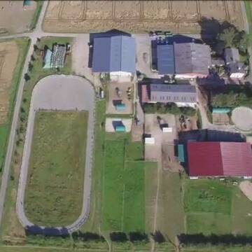
Offenstall Wallache / Rentner - 24/7 Weide
Bad Emstal
Landgrebe Agrar GbR
@LandgrebeAgrar
Freizeitstall
Geländestrecke
Vermieten
Hunde willkommen
Krankenbox
Allergikerstall
Notfallboxen
23 weitere...
P+
Deprecated: Creation of dynamic property Zend_View_Helper_Ads::$adLink is deprecated in /var/www/stall-frei/htdocs/staging.stall-frei.de/library/Psf/View/Helper/Ads.php on line 108

Heu und Heulage verkaufen
Mechtersen
STALL-FREIde Marketing
@STALL-FREI-Marketing
Verkaufen Sie Ihr Heu und Ihre Heulage direkt an Reiter, Pferdeställe und Reitanlagen

Gruppenstall, befestigter Paddock, Weide nach Wahl
Bad Emstal
Landgrebe Agrar GbR
@LandgrebeAgrar
Freizeitstall
Geländestrecke
Vermieten
Hunde willkommen
Krankenbox
Hufrehe geeignet
Notfallboxen
22 weitere...
P
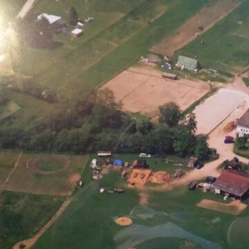
Offenstall Plätze frei
Schauenburg Breitenbach
Langsholt
@Langsholt
Freizeitstall
Gangpferdereiten
Vermieten
Laufband
Longierzirkel/Roundpen
Notfallboxen
Zuchtstutenhaltung möglich
20 weitere...
P

Einstellplatz / Herde/ Paddock-Box
Niedenstein/Kirchberg
Herr-Frau-Gude
@Herr-Frau-Gude
Fahrstall, Kutschwagen
Freizeitstall
Führanlage
Krankenbox
Allergikerstall
Hufrehe geeignet
Außenbox mit Paddock
Außenboxen
24 weitere...
P


Pferdepension Hof Reinbold
Fritzlar
Hof-Reinbold
@Hof-Reinbold
Freizeitstall
Pferdeausbildung
Vermieten
Hunde willkommen
Krankenbox
Gnadenbrothof
Hufrehe geeignet
32 weitere...
P+

Heu aus neuer Ernte
Mechtersen
STALL-FREIde Marketing
@STALL-FREI-Marketing
Heulage und Pferdeheu aus der neuen Ernte findest du in unserem Futtermarkt


Offenstall Selbstversorger
Ahnatal
Angela Klapp
@Angela50
Freizeitstall
Geländestrecke
Hunde willkommen
Parkplatz für Pferdeanhänger
Allergikerstall
Gnadenbrothof
Offenstall
9 weitere...
P+
Leider kein Vorschaubild
Leider kein Vorschaubild
Artgerechte Pferdehaltung in Habichtswald
Habichtswald
Reitanlage-Lindenhof2
@Reitanlage-Lindenhof2
Paddock
Parkplatz für Pferdeanhänger
Außenboxen
Innenbox
Vollpension
Einzelne Boxen oder Stallplätze
8 weitere...
P
Leider kein Vorschaubild
Leider kein Vorschaubild
Offenstallplatz frei
Wolfahgen-Istha
Martina-L1
@Martina-L1
Freizeitstall
Vermieten
Krankenbox
Longierzirkel/Roundpen
Notfallboxen
10 weitere...
brandneu
B

Beisteller Platz, Offenstall + Box
Felsberg
Loretta
@Loretta
Freizeitstall
Geländestrecke
Vermieten
Hunde willkommen
Toilette vorhanden
Hufrehe geeignet
8 weitere...
P
Leider kein Vorschaubild
Leider kein Vorschaubild
Pferdebox frei in nettem Stall mit Solekammer
Wolfhagen
Pferdepension Freckenhausen
@Freckenhausen.Wolfhagen
FN-Mitglied
Freizeitstall
Vermieten
Krankenbox
Paddock
Allergikerstall
Gnadenbrothof
21 weitere...
B
Deprecated: Creation of dynamic property Zend_View::$pageCount is deprecated in /var/www/stall-frei/htdocs/staging.stall-frei.de/library/vendor/shardj/zf1-future/library/Zend/View/Abstract.php on line 308
Deprecated: Creation of dynamic property Zend_View::$itemCountPerPage is deprecated in /var/www/stall-frei/htdocs/staging.stall-frei.de/library/vendor/shardj/zf1-future/library/Zend/View/Abstract.php on line 308
Deprecated: Creation of dynamic property Zend_View::$first is deprecated in /var/www/stall-frei/htdocs/staging.stall-frei.de/library/vendor/shardj/zf1-future/library/Zend/View/Abstract.php on line 308
Deprecated: Creation of dynamic property Zend_View::$current is deprecated in /var/www/stall-frei/htdocs/staging.stall-frei.de/library/vendor/shardj/zf1-future/library/Zend/View/Abstract.php on line 308
Deprecated: Creation of dynamic property Zend_View::$last is deprecated in /var/www/stall-frei/htdocs/staging.stall-frei.de/library/vendor/shardj/zf1-future/library/Zend/View/Abstract.php on line 308
Deprecated: Creation of dynamic property Zend_View::$next is deprecated in /var/www/stall-frei/htdocs/staging.stall-frei.de/library/vendor/shardj/zf1-future/library/Zend/View/Abstract.php on line 308
Deprecated: Creation of dynamic property Zend_View::$pagesInRange is deprecated in /var/www/stall-frei/htdocs/staging.stall-frei.de/library/vendor/shardj/zf1-future/library/Zend/View/Abstract.php on line 308
Deprecated: Creation of dynamic property Zend_View::$firstPageInRange is deprecated in /var/www/stall-frei/htdocs/staging.stall-frei.de/library/vendor/shardj/zf1-future/library/Zend/View/Abstract.php on line 308
Deprecated: Creation of dynamic property Zend_View::$lastPageInRange is deprecated in /var/www/stall-frei/htdocs/staging.stall-frei.de/library/vendor/shardj/zf1-future/library/Zend/View/Abstract.php on line 308
Deprecated: Creation of dynamic property Zend_View::$currentItemCount is deprecated in /var/www/stall-frei/htdocs/staging.stall-frei.de/library/vendor/shardj/zf1-future/library/Zend/View/Abstract.php on line 308
Deprecated: Creation of dynamic property Zend_View::$totalItemCount is deprecated in /var/www/stall-frei/htdocs/staging.stall-frei.de/library/vendor/shardj/zf1-future/library/Zend/View/Abstract.php on line 308
Deprecated: Creation of dynamic property Zend_View::$firstItemNumber is deprecated in /var/www/stall-frei/htdocs/staging.stall-frei.de/library/vendor/shardj/zf1-future/library/Zend/View/Abstract.php on line 308
Deprecated: Creation of dynamic property Zend_View::$lastItemNumber is deprecated in /var/www/stall-frei/htdocs/staging.stall-frei.de/library/vendor/shardj/zf1-future/library/Zend/View/Abstract.php on line 308
Deprecated: Creation of dynamic property Zend_View::$router is deprecated in /var/www/stall-frei/htdocs/staging.stall-frei.de/library/vendor/shardj/zf1-future/library/Zend/View/Abstract.php on line 308
Deprecated: Creation of dynamic property Zend_View::$urlParams is deprecated in /var/www/stall-frei/htdocs/staging.stall-frei.de/library/vendor/shardj/zf1-future/library/Zend/View/Abstract.php on line 308
Deprecated: Creation of dynamic property Zend_View::$showAds is deprecated in /var/www/stall-frei/htdocs/staging.stall-frei.de/library/vendor/shardj/zf1-future/library/Zend/View/Abstract.php on line 308
Deprecated: Creation of dynamic property Zend_View::$objectIds is deprecated in /var/www/stall-frei/htdocs/staging.stall-frei.de/library/vendor/shardj/zf1-future/library/Zend/View/Abstract.php on line 308
Deprecated: Creation of dynamic property Zend_View::$showNavbar is deprecated in /var/www/stall-frei/htdocs/staging.stall-frei.de/library/vendor/shardj/zf1-future/library/Zend/View/Abstract.php on line 308
Deprecated: Creation of dynamic property Zend_View::$showBreadcrumb is deprecated in /var/www/stall-frei/htdocs/staging.stall-frei.de/library/vendor/shardj/zf1-future/library/Zend/View/Abstract.php on line 308
Deprecated: Creation of dynamic property Zend_View::$showFooter is deprecated in /var/www/stall-frei/htdocs/staging.stall-frei.de/library/vendor/shardj/zf1-future/library/Zend/View/Abstract.php on line 308
Deprecated: Creation of dynamic property Zend_View::$showInternalAds is deprecated in /var/www/stall-frei/htdocs/staging.stall-frei.de/library/vendor/shardj/zf1-future/library/Zend/View/Abstract.php on line 308
Deprecated: Creation of dynamic property Zend_View::$blNoContent is deprecated in /var/www/stall-frei/htdocs/staging.stall-frei.de/library/vendor/shardj/zf1-future/library/Zend/View/Abstract.php on line 308
Deprecated: Creation of dynamic property Zend_View::$sMetaDesc is deprecated in /var/www/stall-frei/htdocs/staging.stall-frei.de/library/vendor/shardj/zf1-future/library/Zend/View/Abstract.php on line 308
Deprecated: Creation of dynamic property Zend_View::$useGmaps is deprecated in /var/www/stall-frei/htdocs/staging.stall-frei.de/library/vendor/shardj/zf1-future/library/Zend/View/Abstract.php on line 308
Deprecated: Creation of dynamic property Zend_View::$touches is deprecated in /var/www/stall-frei/htdocs/staging.stall-frei.de/library/vendor/shardj/zf1-future/library/Zend/View/Abstract.php on line 308
Deprecated: Creation of dynamic property Zend_View::$oProject is deprecated in /var/www/stall-frei/htdocs/staging.stall-frei.de/library/vendor/shardj/zf1-future/library/Zend/View/Abstract.php on line 308
Deprecated: Creation of dynamic property Zend_View::$pageHeadline is deprecated in /var/www/stall-frei/htdocs/staging.stall-frei.de/library/vendor/shardj/zf1-future/library/Zend/View/Abstract.php on line 308
Deprecated: Creation of dynamic property Zend_View::$disableLocationField is deprecated in /var/www/stall-frei/htdocs/staging.stall-frei.de/library/vendor/shardj/zf1-future/library/Zend/View/Abstract.php on line 308
Deprecated: Creation of dynamic property Zend_View::$isSearch is deprecated in /var/www/stall-frei/htdocs/staging.stall-frei.de/library/vendor/shardj/zf1-future/library/Zend/View/Abstract.php on line 308
Deprecated: Creation of dynamic property Zend_View::$pageTitle is deprecated in /var/www/stall-frei/htdocs/staging.stall-frei.de/library/vendor/shardj/zf1-future/library/Zend/View/Abstract.php on line 308
Deprecated: Creation of dynamic property Psf_Form_Element_Text::$class is deprecated in /var/www/stall-frei/htdocs/staging.stall-frei.de/library/vendor/shardj/zf1-future/library/Zend/Form/Element.php on line 874
Deprecated: Creation of dynamic property Psf_Form_Element_Text::$size is deprecated in /var/www/stall-frei/htdocs/staging.stall-frei.de/library/vendor/shardj/zf1-future/library/Zend/Form/Element.php on line 874
Deprecated: Creation of dynamic property Psf_Form_Element_Text::$placeholder is deprecated in /var/www/stall-frei/htdocs/staging.stall-frei.de/library/vendor/shardj/zf1-future/library/Zend/Form/Element.php on line 874
Deprecated: Creation of dynamic property Psf_Form_Element_Hidden::$class is deprecated in /var/www/stall-frei/htdocs/staging.stall-frei.de/library/vendor/shardj/zf1-future/library/Zend/Form/Element.php on line 874
Deprecated: Creation of dynamic property Psf_Form_Element_Hidden::$class is deprecated in /var/www/stall-frei/htdocs/staging.stall-frei.de/library/vendor/shardj/zf1-future/library/Zend/Form/Element.php on line 874
Deprecated: Creation of dynamic property Psf_Form_Element_Hidden::$class is deprecated in /var/www/stall-frei/htdocs/staging.stall-frei.de/library/vendor/shardj/zf1-future/library/Zend/Form/Element.php on line 874
Deprecated: Creation of dynamic property Psf_Form_Element_Hidden::$class is deprecated in /var/www/stall-frei/htdocs/staging.stall-frei.de/library/vendor/shardj/zf1-future/library/Zend/Form/Element.php on line 874
Deprecated: Creation of dynamic property Psf_Form_Element_Select::$class is deprecated in /var/www/stall-frei/htdocs/staging.stall-frei.de/library/vendor/shardj/zf1-future/library/Zend/Form/Element.php on line 874
Deprecated: Creation of dynamic property Psf_Form_Element_Select::$class is deprecated in /var/www/stall-frei/htdocs/staging.stall-frei.de/library/vendor/shardj/zf1-future/library/Zend/Form/Element.php on line 874
Deprecated: Creation of dynamic property Psf_Form_Element_Select::$class is deprecated in /var/www/stall-frei/htdocs/staging.stall-frei.de/library/vendor/shardj/zf1-future/library/Zend/Form/Element.php on line 874
Deprecated: Creation of dynamic property Psf_Form_Element_Select::$class is deprecated in /var/www/stall-frei/htdocs/staging.stall-frei.de/library/vendor/shardj/zf1-future/library/Zend/Form/Element.php on line 874
Deprecated: Creation of dynamic property Psf_Form_Element_Text::$class is deprecated in /var/www/stall-frei/htdocs/staging.stall-frei.de/library/vendor/shardj/zf1-future/library/Zend/Form/Element.php on line 874
Deprecated: Creation of dynamic property Psf_Form_Element_Checkbox::$label is deprecated in /var/www/stall-frei/htdocs/staging.stall-frei.de/library/vendor/shardj/zf1-future/library/Zend/Form/Element.php on line 874
Deprecated: Creation of dynamic property Zend_View::$sort is deprecated in /var/www/stall-frei/htdocs/staging.stall-frei.de/library/vendor/shardj/zf1-future/library/Zend/View/Abstract.php on line 308
Deprecated: Creation of dynamic property Zend_View::$searchLocation is deprecated in /var/www/stall-frei/htdocs/staging.stall-frei.de/library/vendor/shardj/zf1-future/library/Zend/View/Abstract.php on line 308
Deprecated: Creation of dynamic property Zend_View::$locationHint is deprecated in /var/www/stall-frei/htdocs/staging.stall-frei.de/library/vendor/shardj/zf1-future/library/Zend/View/Abstract.php on line 308
Psf_GeoCoder_Abstract::getLocation: Sand Get Location CachedOrLive
Psf_GeoCoder_Abstract::getCachedOrLive: Sand
Psf_GeoCoder_OpenCageData::makeApiRequest: response:
Array
(
[documentation] => https://opencagedata.com/api
[licenses] => Array
(
[0] => Array
(
[name] => see attribution guide
[url] => https://opencagedata.com/credits
)
)
[results] => Array
(
[0] => Array
(
[bounds] => Array
(
[northeast] => Array
(
[lat] => 51.2851954
[lng] => 9.3091355
)
[southwest] => Array
(
[lat] => 51.2351003
[lng] => 9.2264494
)
)
[components] => Array
(
[ISO_3166-1_alpha-2] => DE
[ISO_3166-1_alpha-3] => DEU
[ISO_3166-2] => Array
(
[0] => DE-HE
)
[_category] => place
[_normalized_city] => Sand
[_type] => village
[continent] => Europe
[country] => Deutschland
[country_code] => de
[county] => Landkreis Kassel
[municipality] => Bad Emstal
[political_union] => European Union
[postcode] => 34308
[state] => Hessen
[state_code] => HE
[village] => Sand
)
[confidence] => 7
[formatted] => 34308 Sand, Deutschland
[geometry] => Array
(
[lat] => 51.2453113
[lng] => 9.259941
)
)
[1] => Array
(
[bounds] => Array
(
[northeast] => Array
(
[lat] => 49.6992756
[lng] => 11.6498501
)
[southwest] => Array
(
[lat] => 49.6592756
[lng] => 11.6098501
)
)
[components] => Array
(
[ISO_3166-1_alpha-2] => DE
[ISO_3166-1_alpha-3] => DEU
[ISO_3166-2] => Array
(
[0] => DE-BY
)
[_category] => place
[_normalized_city] => Auerbach in der Oberpfalz
[_type] => village
[continent] => Europe
[country] => Deutschland
[country_code] => de
[county] => Landkreis Amberg-Sulzbach
[political_union] => European Union
[postcode] => 91275
[state] => Bayern
[state_code] => BY
[town] => Auerbach in der Oberpfalz
[village] => Sand
)
[confidence] => 7
[formatted] => 91275 Sand, Deutschland
[geometry] => Array
(
[lat] => 49.6792756
[lng] => 11.6298501
)
)
[2] => Array
(
[bounds] => Array
(
[northeast] => Array
(
[lat] => 50.0210169
[lng] => 11.6769487
)
[southwest] => Array
(
[lat] => 49.9810169
[lng] => 11.6369487
)
)
[components] => Array
(
[ISO_3166-1_alpha-2] => DE
[ISO_3166-1_alpha-3] => DEU
[ISO_3166-2] => Array
(
[0] => DE-BY
)
[_category] => place
[_normalized_city] => Goldkronach
[_type] => hamlet
[continent] => Europe
[country] => Deutschland
[country_code] => de
[county] => Landkreis Bayreuth
[hamlet] => Sand
[political_union] => European Union
[postcode] => 95497
[state] => Bayern
[state_code] => BY
[town] => Goldkronach
)
[confidence] => 7
[formatted] => Sand, 95497 Goldkronach, Deutschland
[geometry] => Array
(
[lat] => 50.0010169
[lng] => 11.6569487
)
)
[3] => Array
(
[bounds] => Array
(
[northeast] => Array
(
[lat] => 48.6782941
[lng] => 8.2598184
)
[southwest] => Array
(
[lat] => 48.6382941
[lng] => 8.2198184
)
)
[components] => Array
(
[ISO_3166-1_alpha-2] => DE
[ISO_3166-1_alpha-3] => DEU
[ISO_3166-2] => Array
(
[0] => DE-BW
)
[_category] => place
[_normalized_city] => Bühl
[_type] => hamlet
[continent] => Europe
[country] => Deutschland
[country_code] => de
[county] => Landkreis Rastatt
[hamlet] => Sand
[municipality] => VVG der Stadt Bühl
[political_union] => European Union
[postcode] => 77815
[state] => Baden-Württemberg
[state_code] => BW
[town] => Bühl
)
[confidence] => 7
[formatted] => Sand, 77815 Bühl, Deutschland
[geometry] => Array
(
[lat] => 48.6582941
[lng] => 8.2398184
)
)
[4] => Array
(
[bounds] => Array
(
[northeast] => Array
(
[lat] => 49.4323536
[lng] => 7.4106543
)
[southwest] => Array
(
[lat] => 49.3923536
[lng] => 7.3706543
)
)
[components] => Array
(
[ISO_3166-1_alpha-2] => DE
[ISO_3166-1_alpha-3] => DEU
[ISO_3166-2] => Array
(
[0] => DE-RP
)
[_category] => place
[_normalized_city] => Sand
[_type] => village
[continent] => Europe
[country] => Deutschland
[country_code] => de
[county] => Landkreis Kusel
[municipality] => Oberes Glantal
[political_union] => European Union
[postcode] => 66901
[state] => Rheinland-Pfalz
[state_code] => RP
[town] => Sand
[village] => Schönenberg-Kübelberg
)
[confidence] => 7
[formatted] => 66901 Schönenberg-Kübelberg, Deutschland
[geometry] => Array
(
[lat] => 49.4123536
[lng] => 7.3906543
)
)
[5] => Array
(
[bounds] => Array
(
[northeast] => Array
(
[lat] => 48.7898948
[lng] => 9.9236039
)
[southwest] => Array
(
[lat] => 48.7897948
[lng] => 9.9235039
)
)
[components] => Array
(
[ISO_3166-1_alpha-2] => DE
[ISO_3166-1_alpha-3] => DEU
[ISO_3166-2] => Array
(
[0] => DE-BW
)
[_category] => natural/water
[_normalized_city] => Heubach
[_type] => peak
[continent] => Europe
[country] => Deutschland
[country_code] => de
[county] => Ostalbkreis
[municipality] => GVV Rosenstein
[peak] => Sand
[political_union] => European Union
[postcode] => 73540
[state] => Baden-Württemberg
[state_code] => BW
[town] => Heubach
)
[confidence] => 9
[formatted] => Sand, 73540 Heubach, Deutschland
[geometry] => Array
(
[lat] => 48.7898448
[lng] => 9.9235539
)
)
[6] => Array
(
[bounds] => Array
(
[northeast] => Array
(
[lat] => 48.5583272
[lng] => 7.9408373
)
[southwest] => Array
(
[lat] => 48.5183272
[lng] => 7.9008373
)
)
[components] => Array
(
[ISO_3166-1_alpha-2] => DE
[ISO_3166-1_alpha-3] => DEU
[ISO_3166-2] => Array
(
[0] => DE-BW
)
[_category] => place
[_normalized_city] => Willstätt
[_type] => village
[city] => Willstätt
[continent] => Europe
[country] => Deutschland
[country_code] => de
[county] => Ortenaukreis
[political_union] => European Union
[postcode] => 77731
[state] => Baden-Württemberg
[state_code] => BW
[village] => Sand
)
[confidence] => 7
[formatted] => 77731 Sand, Deutschland
[geometry] => Array
(
[lat] => 48.5383272
[lng] => 7.9208373
)
)
[7] => Array
(
[bounds] => Array
(
[northeast] => Array
(
[lat] => 48.5361152
[lng] => 10.9337141
)
[southwest] => Array
(
[lat] => 48.4961152
[lng] => 10.8937141
)
)
[components] => Array
(
[ISO_3166-1_alpha-2] => DE
[ISO_3166-1_alpha-3] => DEU
[ISO_3166-2] => Array
(
[0] => DE-BY
)
[_category] => place
[_normalized_city] => Todtenweis
[_type] => village
[city] => Todtenweis
[continent] => Europe
[country] => Deutschland
[country_code] => de
[county] => Landkreis Aichach-Friedberg
[municipality] => Aindling
[political_union] => European Union
[postcode] => 86508
[state] => Bayern
[state_code] => BY
[village] => Sand
)
[confidence] => 7
[formatted] => 86508 Sand, Deutschland
[geometry] => Array
(
[lat] => 48.5161152
[lng] => 10.9137141
)
)
[8] => Array
(
[bounds] => Array
(
[northeast] => Array
(
[lat] => 51.0097381
[lng] => 7.1761478
)
[southwest] => Array
(
[lat] => 50.9697381
[lng] => 7.1361478
)
)
[components] => Array
(
[ISO_3166-1_alpha-2] => DE
[ISO_3166-1_alpha-3] => DEU
[ISO_3166-2] => Array
(
[0] => DE-NW
)
[_category] => place
[_normalized_city] => Bergisch Gladbach
[_type] => neighbourhood
[city] => Bergisch Gladbach
[continent] => Europe
[country] => Deutschland
[country_code] => de
[county] => Rheinisch-Bergischer Kreis
[political_union] => European Union
[postcode] => 51465
[state] => Nordrhein-Westfalen
[state_code] => NW
[suburb] => Sand
)
[confidence] => 7
[formatted] => 51465 Bergisch Gladbach, Deutschland
[geometry] => Array
(
[lat] => 50.9897381
[lng] => 7.1561478
)
)
[9] => Array
(
[bounds] => Array
(
[northeast] => Array
(
[lat] => 48.9171277
[lng] => 12.6935685
)
[southwest] => Array
(
[lat] => 48.8771277
[lng] => 12.6535685
)
)
[components] => Array
(
[ISO_3166-1_alpha-2] => DE
[ISO_3166-1_alpha-3] => DEU
[ISO_3166-2] => Array
(
[0] => DE-BY
)
[_category] => place
[_normalized_city] => Aiterhofen
[_type] => village
[city] => Aiterhofen
[continent] => Europe
[country] => Deutschland
[country_code] => de
[county] => Landkreis Straubing-Bogen
[municipality] => Aiterhofen (VGem)
[political_union] => European Union
[postcode] => 94327
[state] => Bayern
[state_code] => BY
[village] => Sand
)
[confidence] => 7
[formatted] => 94327 Sand, Deutschland
[geometry] => Array
(
[lat] => 48.8971277
[lng] => 12.6735685
)
)
)
[status] => Array
(
[code] => 200
[message] => OK
)
[stay_informed] => Array
(
[blog] => https://blog.opencagedata.com
[mastodon] => https://en.osm.town/@opencage
)
[thanks] => For using an OpenCage API
[timestamp] => Array
(
[created_http] => Fri, 06 Feb 2026 19:19:06 GMT
[created_unix] => 1770405546
)
[total_results] => 10
)
Psf_GeoCoder_Abstract::convertLocationResult
{"documentation":"https:\/\/opencagedata.com\/api","licenses":[{"name":"see attribution guide","url":"https:\/\/opencagedata.com\/credits"}],"results":[{"bounds":{"northeast":{"lat":51.2851954,"lng":9.3091355},"southwest":{"lat":51.2351003,"lng":9.2264494}},"components":{"ISO_3166-1_alpha-2":"DE","ISO_3166-1_alpha-3":"DEU","ISO_3166-2":["DE-HE"],"_category":"place","_normalized_city":"Sand","_type":"village","continent":"Europe","country":"Deutschland","country_code":"de","county":"Landkreis Kassel","municipality":"Bad Emstal","political_union":"European Union","postcode":"34308","state":"Hessen","state_code":"HE","village":"Sand"},"confidence":7,"formatted":"34308 Sand, Deutschland","geometry":{"lat":51.2453113,"lng":9.259941}},{"bounds":{"northeast":{"lat":49.6992756,"lng":11.6498501},"southwest":{"lat":49.6592756,"lng":11.6098501}},"components":{"ISO_3166-1_alpha-2":"DE","ISO_3166-1_alpha-3":"DEU","ISO_3166-2":["DE-BY"],"_category":"place","_normalized_city":"Auerbach in der Oberpfalz","_type":"village","continent":"Europe","country":"Deutschland","country_code":"de","county":"Landkreis Amberg-Sulzbach","political_union":"European Union","postcode":"91275","state":"Bayern","state_code":"BY","town":"Auerbach in der Oberpfalz","village":"Sand"},"confidence":7,"formatted":"91275 Sand, Deutschland","geometry":{"lat":49.6792756,"lng":11.6298501}},{"bounds":{"northeast":{"lat":50.0210169,"lng":11.6769487},"southwest":{"lat":49.9810169,"lng":11.6369487}},"components":{"ISO_3166-1_alpha-2":"DE","ISO_3166-1_alpha-3":"DEU","ISO_3166-2":["DE-BY"],"_category":"place","_normalized_city":"Goldkronach","_type":"hamlet","continent":"Europe","country":"Deutschland","country_code":"de","county":"Landkreis Bayreuth","hamlet":"Sand","political_union":"European Union","postcode":"95497","state":"Bayern","state_code":"BY","town":"Goldkronach"},"confidence":7,"formatted":"Sand, 95497 Goldkronach, Deutschland","geometry":{"lat":50.0010169,"lng":11.6569487}},{"bounds":{"northeast":{"lat":48.6782941,"lng":8.2598184},"southwest":{"lat":48.6382941,"lng":8.2198184}},"components":{"ISO_3166-1_alpha-2":"DE","ISO_3166-1_alpha-3":"DEU","ISO_3166-2":["DE-BW"],"_category":"place","_normalized_city":"B\u00fchl","_type":"hamlet","continent":"Europe","country":"Deutschland","country_code":"de","county":"Landkreis Rastatt","hamlet":"Sand","municipality":"VVG der Stadt B\u00fchl","political_union":"European Union","postcode":"77815","state":"Baden-W\u00fcrttemberg","state_code":"BW","town":"B\u00fchl"},"confidence":7,"formatted":"Sand, 77815 B\u00fchl, Deutschland","geometry":{"lat":48.6582941,"lng":8.2398184}},{"bounds":{"northeast":{"lat":49.4323536,"lng":7.4106543},"southwest":{"lat":49.3923536,"lng":7.3706543}},"components":{"ISO_3166-1_alpha-2":"DE","ISO_3166-1_alpha-3":"DEU","ISO_3166-2":["DE-RP"],"_category":"place","_normalized_city":"Sand","_type":"village","continent":"Europe","country":"Deutschland","country_code":"de","county":"Landkreis Kusel","municipality":"Oberes Glantal","political_union":"European Union","postcode":"66901","state":"Rheinland-Pfalz","state_code":"RP","town":"Sand","village":"Sch\u00f6nenberg-K\u00fcbelberg"},"confidence":7,"formatted":"66901 Sch\u00f6nenberg-K\u00fcbelberg, Deutschland","geometry":{"lat":49.4123536,"lng":7.3906543}},{"bounds":{"northeast":{"lat":48.7898948,"lng":9.9236039},"southwest":{"lat":48.7897948,"lng":9.9235039}},"components":{"ISO_3166-1_alpha-2":"DE","ISO_3166-1_alpha-3":"DEU","ISO_3166-2":["DE-BW"],"_category":"natural\/water","_normalized_city":"Heubach","_type":"peak","continent":"Europe","country":"Deutschland","country_code":"de","county":"Ostalbkreis","municipality":"GVV Rosenstein","peak":"Sand","political_union":"European Union","postcode":"73540","state":"Baden-W\u00fcrttemberg","state_code":"BW","town":"Heubach"},"confidence":9,"formatted":"Sand, 73540 Heubach, Deutschland","geometry":{"lat":48.7898448,"lng":9.9235539}},{"bounds":{"northeast":{"lat":48.5583272,"lng":7.9408373},"southwest":{"lat":48.5183272,"lng":7.9008373}},"components":{"ISO_3166-1_alpha-2":"DE","ISO_3166-1_alpha-3":"DEU","ISO_3166-2":["DE-BW"],"_category":"place","_normalized_city":"Willst\u00e4tt","_type":"village","city":"Willst\u00e4tt","continent":"Europe","country":"Deutschland","country_code":"de","county":"Ortenaukreis","political_union":"European Union","postcode":"77731","state":"Baden-W\u00fcrttemberg","state_code":"BW","village":"Sand"},"confidence":7,"formatted":"77731 Sand, Deutschland","geometry":{"lat":48.5383272,"lng":7.9208373}},{"bounds":{"northeast":{"lat":48.5361152,"lng":10.9337141},"southwest":{"lat":48.4961152,"lng":10.8937141}},"components":{"ISO_3166-1_alpha-2":"DE","ISO_3166-1_alpha-3":"DEU","ISO_3166-2":["DE-BY"],"_category":"place","_normalized_city":"Todtenweis","_type":"village","city":"Todtenweis","continent":"Europe","country":"Deutschland","country_code":"de","county":"Landkreis Aichach-Friedberg","municipality":"Aindling","political_union":"European Union","postcode":"86508","state":"Bayern","state_code":"BY","village":"Sand"},"confidence":7,"formatted":"86508 Sand, Deutschland","geometry":{"lat":48.5161152,"lng":10.9137141}},{"bounds":{"northeast":{"lat":51.0097381,"lng":7.1761478},"southwest":{"lat":50.9697381,"lng":7.1361478}},"components":{"ISO_3166-1_alpha-2":"DE","ISO_3166-1_alpha-3":"DEU","ISO_3166-2":["DE-NW"],"_category":"place","_normalized_city":"Bergisch Gladbach","_type":"neighbourhood","city":"Bergisch Gladbach","continent":"Europe","country":"Deutschland","country_code":"de","county":"Rheinisch-Bergischer Kreis","political_union":"European Union","postcode":"51465","state":"Nordrhein-Westfalen","state_code":"NW","suburb":"Sand"},"confidence":7,"formatted":"51465 Bergisch Gladbach, Deutschland","geometry":{"lat":50.9897381,"lng":7.1561478}},{"bounds":{"northeast":{"lat":48.9171277,"lng":12.6935685},"southwest":{"lat":48.8771277,"lng":12.6535685}},"components":{"ISO_3166-1_alpha-2":"DE","ISO_3166-1_alpha-3":"DEU","ISO_3166-2":["DE-BY"],"_category":"place","_normalized_city":"Aiterhofen","_type":"village","city":"Aiterhofen","continent":"Europe","country":"Deutschland","country_code":"de","county":"Landkreis Straubing-Bogen","municipality":"Aiterhofen (VGem)","political_union":"European Union","postcode":"94327","state":"Bayern","state_code":"BY","village":"Sand"},"confidence":7,"formatted":"94327 Sand, Deutschland","geometry":{"lat":48.8971277,"lng":12.6735685}}],"status":{"code":200,"message":"OK"},"stay_informed":{"blog":"https:\/\/blog.opencagedata.com","mastodon":"https:\/\/en.osm.town\/@opencage"},"thanks":"For using an OpenCage API","timestamp":{"created_http":"Fri, 06 Feb 2026 19:19:06 GMT","created_unix":1770405546},"total_results":10}Array
(
[0] => stdClass Object
(
[bounds] => stdClass Object
(
[northeast] => stdClass Object
(
[lat] => 51.2851954
[lng] => 9.3091355
)
[southwest] => stdClass Object
(
[lat] => 51.2351003
[lng] => 9.2264494
)
)
[components] => stdClass Object
(
[ISO_3166-1_alpha-2] => DE
[ISO_3166-1_alpha-3] => DEU
[ISO_3166-2] => Array
(
[0] => DE-HE
)
[_category] => place
[_normalized_city] => Sand
[_type] => village
[continent] => Europe
[country] => Deutschland
[country_code] => de
[county] => Landkreis Kassel
[municipality] => Bad Emstal
[political_union] => European Union
[postcode] => 34308
[state] => Hessen
[state_code] => HE
[village] => Sand
)
[confidence] => 7
[formatted] => 34308 Sand, Deutschland
[geometry] => stdClass Object
(
[lat] => 51.2453113
[lng] => 9.259941
)
)
[1] => stdClass Object
(
[bounds] => stdClass Object
(
[northeast] => stdClass Object
(
[lat] => 49.6992756
[lng] => 11.6498501
)
[southwest] => stdClass Object
(
[lat] => 49.6592756
[lng] => 11.6098501
)
)
[components] => stdClass Object
(
[ISO_3166-1_alpha-2] => DE
[ISO_3166-1_alpha-3] => DEU
[ISO_3166-2] => Array
(
[0] => DE-BY
)
[_category] => place
[_normalized_city] => Auerbach in der Oberpfalz
[_type] => village
[continent] => Europe
[country] => Deutschland
[country_code] => de
[county] => Landkreis Amberg-Sulzbach
[political_union] => European Union
[postcode] => 91275
[state] => Bayern
[state_code] => BY
[town] => Auerbach in der Oberpfalz
[village] => Sand
)
[confidence] => 7
[formatted] => 91275 Sand, Deutschland
[geometry] => stdClass Object
(
[lat] => 49.6792756
[lng] => 11.6298501
)
)
[2] => stdClass Object
(
[bounds] => stdClass Object
(
[northeast] => stdClass Object
(
[lat] => 50.0210169
[lng] => 11.6769487
)
[southwest] => stdClass Object
(
[lat] => 49.9810169
[lng] => 11.6369487
)
)
[components] => stdClass Object
(
[ISO_3166-1_alpha-2] => DE
[ISO_3166-1_alpha-3] => DEU
[ISO_3166-2] => Array
(
[0] => DE-BY
)
[_category] => place
[_normalized_city] => Goldkronach
[_type] => hamlet
[continent] => Europe
[country] => Deutschland
[country_code] => de
[county] => Landkreis Bayreuth
[hamlet] => Sand
[political_union] => European Union
[postcode] => 95497
[state] => Bayern
[state_code] => BY
[town] => Goldkronach
)
[confidence] => 7
[formatted] => Sand, 95497 Goldkronach, Deutschland
[geometry] => stdClass Object
(
[lat] => 50.0010169
[lng] => 11.6569487
)
)
[3] => stdClass Object
(
[bounds] => stdClass Object
(
[northeast] => stdClass Object
(
[lat] => 48.6782941
[lng] => 8.2598184
)
[southwest] => stdClass Object
(
[lat] => 48.6382941
[lng] => 8.2198184
)
)
[components] => stdClass Object
(
[ISO_3166-1_alpha-2] => DE
[ISO_3166-1_alpha-3] => DEU
[ISO_3166-2] => Array
(
[0] => DE-BW
)
[_category] => place
[_normalized_city] => Bühl
[_type] => hamlet
[continent] => Europe
[country] => Deutschland
[country_code] => de
[county] => Landkreis Rastatt
[hamlet] => Sand
[municipality] => VVG der Stadt Bühl
[political_union] => European Union
[postcode] => 77815
[state] => Baden-Württemberg
[state_code] => BW
[town] => Bühl
)
[confidence] => 7
[formatted] => Sand, 77815 Bühl, Deutschland
[geometry] => stdClass Object
(
[lat] => 48.6582941
[lng] => 8.2398184
)
)
[4] => stdClass Object
(
[bounds] => stdClass Object
(
[northeast] => stdClass Object
(
[lat] => 49.4323536
[lng] => 7.4106543
)
[southwest] => stdClass Object
(
[lat] => 49.3923536
[lng] => 7.3706543
)
)
[components] => stdClass Object
(
[ISO_3166-1_alpha-2] => DE
[ISO_3166-1_alpha-3] => DEU
[ISO_3166-2] => Array
(
[0] => DE-RP
)
[_category] => place
[_normalized_city] => Sand
[_type] => village
[continent] => Europe
[country] => Deutschland
[country_code] => de
[county] => Landkreis Kusel
[municipality] => Oberes Glantal
[political_union] => European Union
[postcode] => 66901
[state] => Rheinland-Pfalz
[state_code] => RP
[town] => Sand
[village] => Schönenberg-Kübelberg
)
[confidence] => 7
[formatted] => 66901 Schönenberg-Kübelberg, Deutschland
[geometry] => stdClass Object
(
[lat] => 49.4123536
[lng] => 7.3906543
)
)
[5] => stdClass Object
(
[bounds] => stdClass Object
(
[northeast] => stdClass Object
(
[lat] => 48.7898948
[lng] => 9.9236039
)
[southwest] => stdClass Object
(
[lat] => 48.7897948
[lng] => 9.9235039
)
)
[components] => stdClass Object
(
[ISO_3166-1_alpha-2] => DE
[ISO_3166-1_alpha-3] => DEU
[ISO_3166-2] => Array
(
[0] => DE-BW
)
[_category] => natural/water
[_normalized_city] => Heubach
[_type] => peak
[continent] => Europe
[country] => Deutschland
[country_code] => de
[county] => Ostalbkreis
[municipality] => GVV Rosenstein
[peak] => Sand
[political_union] => European Union
[postcode] => 73540
[state] => Baden-Württemberg
[state_code] => BW
[town] => Heubach
)
[confidence] => 9
[formatted] => Sand, 73540 Heubach, Deutschland
[geometry] => stdClass Object
(
[lat] => 48.7898448
[lng] => 9.9235539
)
)
[6] => stdClass Object
(
[bounds] => stdClass Object
(
[northeast] => stdClass Object
(
[lat] => 48.5583272
[lng] => 7.9408373
)
[southwest] => stdClass Object
(
[lat] => 48.5183272
[lng] => 7.9008373
)
)
[components] => stdClass Object
(
[ISO_3166-1_alpha-2] => DE
[ISO_3166-1_alpha-3] => DEU
[ISO_3166-2] => Array
(
[0] => DE-BW
)
[_category] => place
[_normalized_city] => Willstätt
[_type] => village
[city] => Willstätt
[continent] => Europe
[country] => Deutschland
[country_code] => de
[county] => Ortenaukreis
[political_union] => European Union
[postcode] => 77731
[state] => Baden-Württemberg
[state_code] => BW
[village] => Sand
)
[confidence] => 7
[formatted] => 77731 Sand, Deutschland
[geometry] => stdClass Object
(
[lat] => 48.5383272
[lng] => 7.9208373
)
)
[7] => stdClass Object
(
[bounds] => stdClass Object
(
[northeast] => stdClass Object
(
[lat] => 48.5361152
[lng] => 10.9337141
)
[southwest] => stdClass Object
(
[lat] => 48.4961152
[lng] => 10.8937141
)
)
[components] => stdClass Object
(
[ISO_3166-1_alpha-2] => DE
[ISO_3166-1_alpha-3] => DEU
[ISO_3166-2] => Array
(
[0] => DE-BY
)
[_category] => place
[_normalized_city] => Todtenweis
[_type] => village
[city] => Todtenweis
[continent] => Europe
[country] => Deutschland
[country_code] => de
[county] => Landkreis Aichach-Friedberg
[municipality] => Aindling
[political_union] => European Union
[postcode] => 86508
[state] => Bayern
[state_code] => BY
[village] => Sand
)
[confidence] => 7
[formatted] => 86508 Sand, Deutschland
[geometry] => stdClass Object
(
[lat] => 48.5161152
[lng] => 10.9137141
)
)
[8] => stdClass Object
(
[bounds] => stdClass Object
(
[northeast] => stdClass Object
(
[lat] => 51.0097381
[lng] => 7.1761478
)
[southwest] => stdClass Object
(
[lat] => 50.9697381
[lng] => 7.1361478
)
)
[components] => stdClass Object
(
[ISO_3166-1_alpha-2] => DE
[ISO_3166-1_alpha-3] => DEU
[ISO_3166-2] => Array
(
[0] => DE-NW
)
[_category] => place
[_normalized_city] => Bergisch Gladbach
[_type] => neighbourhood
[city] => Bergisch Gladbach
[continent] => Europe
[country] => Deutschland
[country_code] => de
[county] => Rheinisch-Bergischer Kreis
[political_union] => European Union
[postcode] => 51465
[state] => Nordrhein-Westfalen
[state_code] => NW
[suburb] => Sand
)
[confidence] => 7
[formatted] => 51465 Bergisch Gladbach, Deutschland
[geometry] => stdClass Object
(
[lat] => 50.9897381
[lng] => 7.1561478
)
)
[9] => stdClass Object
(
[bounds] => stdClass Object
(
[northeast] => stdClass Object
(
[lat] => 48.9171277
[lng] => 12.6935685
)
[southwest] => stdClass Object
(
[lat] => 48.8771277
[lng] => 12.6535685
)
)
[components] => stdClass Object
(
[ISO_3166-1_alpha-2] => DE
[ISO_3166-1_alpha-3] => DEU
[ISO_3166-2] => Array
(
[0] => DE-BY
)
[_category] => place
[_normalized_city] => Aiterhofen
[_type] => village
[city] => Aiterhofen
[continent] => Europe
[country] => Deutschland
[country_code] => de
[county] => Landkreis Straubing-Bogen
[municipality] => Aiterhofen (VGem)
[political_union] => European Union
[postcode] => 94327
[state] => Bayern
[state_code] => BY
[village] => Sand
)
[confidence] => 7
[formatted] => 94327 Sand, Deutschland
[geometry] => stdClass Object
(
[lat] => 48.8971277
[lng] => 12.6735685
)
)
)
Psf_GeoCoder_OpenCageData::getKeyMap: 0
stdClass Object
(
    [bounds] => stdClass Object
        (
            [northeast] => stdClass Object
                (
                    [lat] => 51.2851954
                    [lng] => 9.3091355
                )

            [southwest] => stdClass Object
                (
                    [lat] => 51.2351003
                    [lng] => 9.2264494
                )

        )

    [components] => stdClass Object
        (
            [ISO_3166-1_alpha-2] => DE
            [ISO_3166-1_alpha-3] => DEU
            [ISO_3166-2] => Array
                (
                    [0] => DE-HE
                )

            [_category] => place
            [_normalized_city] => Sand
            [_type] => village
            [continent] => Europe
            [country] => Deutschland
            [country_code] => de
            [county] => Landkreis Kassel
            [municipality] => Bad Emstal
            [political_union] => European Union
            [postcode] => 34308
            [state] => Hessen
            [state_code] => HE
            [village] => Sand
        )

    [confidence] => 7
    [formatted] => 34308 Sand, Deutschland
    [geometry] => stdClass Object
        (
            [lat] => 51.2453113
            [lng] => 9.259941
        )

)
Psf_GeoCoder_OpenCageData::getCounty: Kassel
Psf_GeoCoder_OpenCageData::addMissingData REFETCH!
Array
(
    [address] => 34308 Sand, Deutschland
    [type] => village
    [street] =>
    [city] => Sand
    [county] => Kassel
    [state] => Hessen
    [zip] => 34308
    [country] => Deutschland
    [suburb] =>
    [countrycode] => de
    [latitude] => 51.2453113
    [longitude] => 9.259941
    [accuracy] => 1
    [confidence] => 7
    [bounds] => stdClass Object
        (
            [northeast] => stdClass Object
                (
                    [lat] => 51.2851954
                    [lng] => 9.3091355
                )

            [southwest] => stdClass Object
                (
                    [lat] => 51.2351003
                    [lng] => 9.2264494
                )

        )

)
reformat!
Array
(
    [address] => 34308 Sand, Deutschland
    [type] => village
    [street] =>
    [city] => Sand
    [county] => Kassel
    [state] => Hessen
    [zip] => 34308
    [country] => Deutschland
    [suburb] =>
    [countrycode] => de
    [latitude] => 51.2453113
    [longitude] => 9.259941
    [accuracy] => 1
    [confidence] => 7
    [bounds] => stdClass Object
        (
            [northeast] => stdClass Object
                (
                    [lat] => 51.2851954
                    [lng] => 9.3091355
                )

            [southwest] => stdClass Object
                (
                    [lat] => 51.2351003
                    [lng] => 9.2264494
                )

        )

    [place] => 34308 Sand, Hessen
    [hash] => b9a7f010c71a8f171511b6b2e611e0c4
)
Psf_GeoCoder_OpenCageData::getKeyMap: 1
stdClass Object
(
    [bounds] => stdClass Object
        (
            [northeast] => stdClass Object
                (
                    [lat] => 49.6992756
                    [lng] => 11.6498501
                )

            [southwest] => stdClass Object
                (
                    [lat] => 49.6592756
                    [lng] => 11.6098501
                )

        )

    [components] => stdClass Object
        (
            [ISO_3166-1_alpha-2] => DE
            [ISO_3166-1_alpha-3] => DEU
            [ISO_3166-2] => Array
                (
                    [0] => DE-BY
                )

            [_category] => place
            [_normalized_city] => Auerbach in der Oberpfalz
            [_type] => village
            [continent] => Europe
            [country] => Deutschland
            [country_code] => de
            [county] => Landkreis Amberg-Sulzbach
            [political_union] => European Union
            [postcode] => 91275
            [state] => Bayern
            [state_code] => BY
            [town] => Auerbach in der Oberpfalz
            [village] => Sand
        )

    [confidence] => 7
    [formatted] => 91275 Sand, Deutschland
    [geometry] => stdClass Object
        (
            [lat] => 49.6792756
            [lng] => 11.6298501
        )

)
Psf_GeoCoder_OpenCageData::getCounty: Amberg-Sulzbach
Psf_GeoCoder_OpenCageData::addMissingData REFETCH!
Array
(
    [address] => 91275 Sand, Deutschland
    [type] => village
    [street] =>
    [city] => Auerbach in der Oberpfalz
    [county] => Amberg-Sulzbach
    [state] => Bayern
    [zip] => 91275
    [country] => Deutschland
    [suburb] =>
    [countrycode] => de
    [latitude] => 49.6792756
    [longitude] => 11.6298501
    [accuracy] => 1
    [confidence] => 7
    [bounds] => stdClass Object
        (
            [northeast] => stdClass Object
                (
                    [lat] => 49.6992756
                    [lng] => 11.6498501
                )

            [southwest] => stdClass Object
                (
                    [lat] => 49.6592756
                    [lng] => 11.6098501
                )

        )

)
reformat!
Array
(
    [address] => 91275 Auerbach in der Oberpfalz
    [type] => village
    [street] =>
    [city] => Auerbach in der Oberpfalz
    [county] => Amberg-Sulzbach
    [state] => Bayern
    [zip] => 91275
    [country] => Deutschland
    [suburb] =>
    [countrycode] => de
    [latitude] => 49.6792756
    [longitude] => 11.6298501
    [accuracy] => 1
    [confidence] => 7
    [bounds] => stdClass Object
        (
            [northeast] => stdClass Object
                (
                    [lat] => 49.6992756
                    [lng] => 11.6498501
                )

            [southwest] => stdClass Object
                (
                    [lat] => 49.6592756
                    [lng] => 11.6098501
                )

        )

    [place] => 91275 Auerbach in der Oberpfalz, Bayern
    [hash] => aa488f5c3a7a140394792b55eb722c47
)
Psf_GeoCoder_OpenCageData::getKeyMap: 2
stdClass Object
(
    [bounds] => stdClass Object
        (
            [northeast] => stdClass Object
                (
                    [lat] => 50.0210169
                    [lng] => 11.6769487
                )

            [southwest] => stdClass Object
                (
                    [lat] => 49.9810169
                    [lng] => 11.6369487
                )

        )

    [components] => stdClass Object
        (
            [ISO_3166-1_alpha-2] => DE
            [ISO_3166-1_alpha-3] => DEU
            [ISO_3166-2] => Array
                (
                    [0] => DE-BY
                )

            [_category] => place
            [_normalized_city] => Goldkronach
            [_type] => hamlet
            [continent] => Europe
            [country] => Deutschland
            [country_code] => de
            [county] => Landkreis Bayreuth
            [hamlet] => Sand
            [political_union] => European Union
            [postcode] => 95497
            [state] => Bayern
            [state_code] => BY
            [town] => Goldkronach
        )

    [confidence] => 7
    [formatted] => Sand, 95497 Goldkronach, Deutschland
    [geometry] => stdClass Object
        (
            [lat] => 50.0010169
            [lng] => 11.6569487
        )

)
Psf_GeoCoder_OpenCageData::getCounty: Bayreuth
Psf_GeoCoder_OpenCageData::addMissingData REFETCH!
Array
(
    [address] => Sand, 95497 Goldkronach, Deutschland
    [type] => hamlet
    [street] => Sand
    [city] => Goldkronach
    [county] => Bayreuth
    [state] => Bayern
    [zip] => 95497
    [country] => Deutschland
    [suburb] =>
    [countrycode] => de
    [latitude] => 50.0010169
    [longitude] => 11.6569487
    [accuracy] => 1
    [confidence] => 7
    [bounds] => stdClass Object
        (
            [northeast] => stdClass Object
                (
                    [lat] => 50.0210169
                    [lng] => 11.6769487
                )

            [southwest] => stdClass Object
                (
                    [lat] => 49.9810169
                    [lng] => 11.6369487
                )

        )

)
reformat!
Array
(
    [address] => Sand, 95497 Goldkronach, Deutschland
    [type] => hamlet
    [street] => Sand
    [city] => Goldkronach
    [county] => Bayreuth
    [state] => Bayern
    [zip] => 95497
    [country] => Deutschland
    [suburb] =>
    [countrycode] => de
    [latitude] => 50.0010169
    [longitude] => 11.6569487
    [accuracy] => 1
    [confidence] => 7
    [bounds] => stdClass Object
        (
            [northeast] => stdClass Object
                (
                    [lat] => 50.0210169
                    [lng] => 11.6769487
                )

            [southwest] => stdClass Object
                (
                    [lat] => 49.9810169
                    [lng] => 11.6369487
                )

        )

    [place] => Sand, 95497 Goldkronach, Bayern
    [hash] => 21bf922dcf30899eb7c40d81c1b2d32f
)
Psf_GeoCoder_OpenCageData::getKeyMap: 3
stdClass Object
(
    [bounds] => stdClass Object
        (
            [northeast] => stdClass Object
                (
                    [lat] => 48.6782941
                    [lng] => 8.2598184
                )

            [southwest] => stdClass Object
                (
                    [lat] => 48.6382941
                    [lng] => 8.2198184
                )

        )

    [components] => stdClass Object
        (
            [ISO_3166-1_alpha-2] => DE
            [ISO_3166-1_alpha-3] => DEU
            [ISO_3166-2] => Array
                (
                    [0] => DE-BW
                )

            [_category] => place
            [_normalized_city] => Bühl
            [_type] => hamlet
            [continent] => Europe
            [country] => Deutschland
            [country_code] => de
            [county] => Landkreis Rastatt
            [hamlet] => Sand
            [municipality] => VVG der Stadt Bühl
            [political_union] => European Union
            [postcode] => 77815
            [state] => Baden-Württemberg
            [state_code] => BW
            [town] => Bühl
        )

    [confidence] => 7
    [formatted] => Sand, 77815 Bühl, Deutschland
    [geometry] => stdClass Object
        (
            [lat] => 48.6582941
            [lng] => 8.2398184
        )

)
Psf_GeoCoder_OpenCageData::getCounty: Rastatt
Psf_GeoCoder_OpenCageData::addMissingData REFETCH!
Array
(
    [address] => Sand, 77815 Bühl, Deutschland
    [type] => hamlet
    [street] => Sand
    [city] => Bühl
    [county] => Rastatt
    [state] => Baden-Württemberg
    [zip] => 77815
    [country] => Deutschland
    [suburb] =>
    [countrycode] => de
    [latitude] => 48.6582941
    [longitude] => 8.2398184
    [accuracy] => 1
    [confidence] => 7
    [bounds] => stdClass Object
        (
            [northeast] => stdClass Object
                (
                    [lat] => 48.6782941
                    [lng] => 8.2598184
                )

            [southwest] => stdClass Object
                (
                    [lat] => 48.6382941
                    [lng] => 8.2198184
                )

        )

)
reformat!
Array
(
    [address] => Sand, 77815 Bühl, Deutschland
    [type] => hamlet
    [street] => Sand
    [city] => Bühl
    [county] => Rastatt
    [state] => Baden-Württemberg
    [zip] => 77815
    [country] => Deutschland
    [suburb] =>
    [countrycode] => de
    [latitude] => 48.6582941
    [longitude] => 8.2398184
    [accuracy] => 1
    [confidence] => 7
    [bounds] => stdClass Object
        (
            [northeast] => stdClass Object
                (
                    [lat] => 48.6782941
                    [lng] => 8.2598184
                )

            [southwest] => stdClass Object
                (
                    [lat] => 48.6382941
                    [lng] => 8.2198184
                )

        )

    [place] => Sand, 77815 Bühl, Baden-Württemberg
    [hash] => ad6b24dd85696192e3a4e5c15c5579eb
)
Psf_GeoCoder_OpenCageData::getKeyMap: 4
stdClass Object
(
    [bounds] => stdClass Object
        (
            [northeast] => stdClass Object
                (
                    [lat] => 49.4323536
                    [lng] => 7.4106543
                )

            [southwest] => stdClass Object
                (
                    [lat] => 49.3923536
                    [lng] => 7.3706543
                )

        )

    [components] => stdClass Object
        (
            [ISO_3166-1_alpha-2] => DE
            [ISO_3166-1_alpha-3] => DEU
            [ISO_3166-2] => Array
                (
                    [0] => DE-RP
                )

            [_category] => place
            [_normalized_city] => Sand
            [_type] => village
            [continent] => Europe
            [country] => Deutschland
            [country_code] => de
            [county] => Landkreis Kusel
            [municipality] => Oberes Glantal
            [political_union] => European Union
            [postcode] => 66901
            [state] => Rheinland-Pfalz
            [state_code] => RP
            [town] => Sand
            [village] => Schönenberg-Kübelberg
        )

    [confidence] => 7
    [formatted] => 66901 Schönenberg-Kübelberg, Deutschland
    [geometry] => stdClass Object
        (
            [lat] => 49.4123536
            [lng] => 7.3906543
        )

)
Psf_GeoCoder_OpenCageData::getCounty: Kusel
Psf_GeoCoder_OpenCageData::addMissingData REFETCH!
Array
(
    [address] => 66901 Schönenberg-Kübelberg, Deutschland
    [type] => village
    [street] =>
    [city] => Sand
    [county] => Kusel
    [state] => Rheinland-Pfalz
    [zip] => 66901
    [country] => Deutschland
    [suburb] =>
    [countrycode] => de
    [latitude] => 49.4123536
    [longitude] => 7.3906543
    [accuracy] => 1
    [confidence] => 7
    [bounds] => stdClass Object
        (
            [northeast] => stdClass Object
                (
                    [lat] => 49.4323536
                    [lng] => 7.4106543
                )

            [southwest] => stdClass Object
                (
                    [lat] => 49.3923536
                    [lng] => 7.3706543
                )

        )

)
reformat!
Array
(
    [address] => 66901 Sand
    [type] => village
    [street] =>
    [city] => Sand
    [county] => Kusel
    [state] => Rheinland-Pfalz
    [zip] => 66901
    [country] => Deutschland
    [suburb] =>
    [countrycode] => de
    [latitude] => 49.4123536
    [longitude] => 7.3906543
    [accuracy] => 1
    [confidence] => 7
    [bounds] => stdClass Object
        (
            [northeast] => stdClass Object
                (
                    [lat] => 49.4323536
                    [lng] => 7.4106543
                )

            [southwest] => stdClass Object
                (
                    [lat] => 49.3923536
                    [lng] => 7.3706543
                )

        )

    [place] => 66901 Sand, Rheinland-Pfalz
    [hash] => 8f0c813fe586e82f77abdb842de954c0
)
Psf_GeoCoder_OpenCageData::getKeyMap: 5
stdClass Object
(
    [bounds] => stdClass Object
        (
            [northeast] => stdClass Object
                (
                    [lat] => 48.7898948
                    [lng] => 9.9236039
                )

            [southwest] => stdClass Object
                (
                    [lat] => 48.7897948
                    [lng] => 9.9235039
                )

        )

    [components] => stdClass Object
        (
            [ISO_3166-1_alpha-2] => DE
            [ISO_3166-1_alpha-3] => DEU
            [ISO_3166-2] => Array
                (
                    [0] => DE-BW
                )

            [_category] => natural/water
            [_normalized_city] => Heubach
            [_type] => peak
            [continent] => Europe
            [country] => Deutschland
            [country_code] => de
            [county] => Ostalbkreis
            [municipality] => GVV Rosenstein
            [peak] => Sand
            [political_union] => European Union
            [postcode] => 73540
            [state] => Baden-Württemberg
            [state_code] => BW
            [town] => Heubach
        )

    [confidence] => 9
    [formatted] => Sand, 73540 Heubach, Deutschland
    [geometry] => stdClass Object
        (
            [lat] => 48.7898448
            [lng] => 9.9235539
        )

)
Psf_GeoCoder_OpenCageData::getCounty: Ostalbkreis
Psf_GeoCoder_OpenCageData::addMissingData REFETCH!
Array
(
    [address] => Sand, 73540 Heubach, Deutschland
    [type] => peak
    [street] =>
    [city] => Heubach
    [county] => Ostalbkreis
    [state] => Baden-Württemberg
    [zip] => 73540
    [country] => Deutschland
    [suburb] =>
    [countrycode] => de
    [latitude] => 48.7898448
    [longitude] => 9.9235539
    [accuracy] => 1
    [confidence] => 9
    [bounds] => stdClass Object
        (
            [northeast] => stdClass Object
                (
                    [lat] => 48.7898948
                    [lng] => 9.9236039
                )

            [southwest] => stdClass Object
                (
                    [lat] => 48.7897948
                    [lng] => 9.9235039
                )

        )

)
reformat!
Array
(
    [address] => Sand, 73540 Heubach, Deutschland
    [type] => peak
    [street] =>
    [city] => Heubach
    [county] => Ostalbkreis
    [state] => Baden-Württemberg
    [zip] => 73540
    [country] => Deutschland
    [suburb] =>
    [countrycode] => de
    [latitude] => 48.7898448
    [longitude] => 9.9235539
    [accuracy] => 1
    [confidence] => 9
    [bounds] => stdClass Object
        (
            [northeast] => stdClass Object
                (
                    [lat] => 48.7898948
                    [lng] => 9.9236039
                )

            [southwest] => stdClass Object
                (
                    [lat] => 48.7897948
                    [lng] => 9.9235039
                )

        )

    [place] => 73540 Heubach, Baden-Württemberg
    [hash] => 3e92fd2175c4630d634d3318c6846079
)
Psf_GeoCoder_OpenCageData::getKeyMap: 6
stdClass Object
(
    [bounds] => stdClass Object
        (
            [northeast] => stdClass Object
                (
                    [lat] => 48.5583272
                    [lng] => 7.9408373
                )

            [southwest] => stdClass Object
                (
                    [lat] => 48.5183272
                    [lng] => 7.9008373
                )

        )

    [components] => stdClass Object
        (
            [ISO_3166-1_alpha-2] => DE
            [ISO_3166-1_alpha-3] => DEU
            [ISO_3166-2] => Array
                (
                    [0] => DE-BW
                )

            [_category] => place
            [_normalized_city] => Willstätt
            [_type] => village
            [city] => Willstätt
            [continent] => Europe
            [country] => Deutschland
            [country_code] => de
            [county] => Ortenaukreis
            [political_union] => European Union
            [postcode] => 77731
            [state] => Baden-Württemberg
            [state_code] => BW
            [village] => Sand
        )

    [confidence] => 7
    [formatted] => 77731 Sand, Deutschland
    [geometry] => stdClass Object
        (
            [lat] => 48.5383272
            [lng] => 7.9208373
        )

)
Psf_GeoCoder_OpenCageData::getCounty: Ortenaukreis
Psf_GeoCoder_OpenCageData::addMissingData REFETCH!
Array
(
    [address] => 77731 Sand, Deutschland
    [type] => village
    [street] =>
    [city] => Sand
    [county] => Ortenaukreis
    [state] => Baden-Württemberg
    [zip] => 77731
    [country] => Deutschland
    [suburb] =>
    [countrycode] => de
    [latitude] => 48.5383272
    [longitude] => 7.9208373
    [accuracy] => 1
    [confidence] => 7
    [bounds] => stdClass Object
        (
            [northeast] => stdClass Object
                (
                    [lat] => 48.5583272
                    [lng] => 7.9408373
                )

            [southwest] => stdClass Object
                (
                    [lat] => 48.5183272
                    [lng] => 7.9008373
                )

        )

)
reformat!
Array
(
    [address] => 77731 Sand, Deutschland
    [type] => village
    [street] =>
    [city] => Sand
    [county] => Ortenaukreis
    [state] => Baden-Württemberg
    [zip] => 77731
    [country] => Deutschland
    [suburb] =>
    [countrycode] => de
    [latitude] => 48.5383272
    [longitude] => 7.9208373
    [accuracy] => 1
    [confidence] => 7
    [bounds] => stdClass Object
        (
            [northeast] => stdClass Object
                (
                    [lat] => 48.5583272
                    [lng] => 7.9408373
                )

            [southwest] => stdClass Object
                (
                    [lat] => 48.5183272
                    [lng] => 7.9008373
                )

        )

    [place] => 77731 Sand, Baden-Württemberg
    [hash] => f69048d11046c7ddd1c5b304443c60af
)
Psf_GeoCoder_OpenCageData::getKeyMap: 7
stdClass Object
(
    [bounds] => stdClass Object
        (
            [northeast] => stdClass Object
                (
                    [lat] => 48.5361152
                    [lng] => 10.9337141
                )

            [southwest] => stdClass Object
                (
                    [lat] => 48.4961152
                    [lng] => 10.8937141
                )

        )

    [components] => stdClass Object
        (
            [ISO_3166-1_alpha-2] => DE
            [ISO_3166-1_alpha-3] => DEU
            [ISO_3166-2] => Array
                (
                    [0] => DE-BY
                )

            [_category] => place
            [_normalized_city] => Todtenweis
            [_type] => village
            [city] => Todtenweis
            [continent] => Europe
            [country] => Deutschland
            [country_code] => de
            [county] => Landkreis Aichach-Friedberg
            [municipality] => Aindling
            [political_union] => European Union
            [postcode] => 86508
            [state] => Bayern
            [state_code] => BY
            [village] => Sand
        )

    [confidence] => 7
    [formatted] => 86508 Sand, Deutschland
    [geometry] => stdClass Object
        (
            [lat] => 48.5161152
            [lng] => 10.9137141
        )

)
Psf_GeoCoder_OpenCageData::getCounty: Aichach-Friedberg
Psf_GeoCoder_OpenCageData::addMissingData REFETCH!
Array
(
    [address] => 86508 Sand, Deutschland
    [type] => village
    [street] =>
    [city] => Sand
    [county] => Aichach-Friedberg
    [state] => Bayern
    [zip] => 86508
    [country] => Deutschland
    [suburb] =>
    [countrycode] => de
    [latitude] => 48.5161152
    [longitude] => 10.9137141
    [accuracy] => 1
    [confidence] => 7
    [bounds] => stdClass Object
        (
            [northeast] => stdClass Object
                (
                    [lat] => 48.5361152
                    [lng] => 10.9337141
                )

            [southwest] => stdClass Object
                (
                    [lat] => 48.4961152
                    [lng] => 10.8937141
                )

        )

)
reformat!
Array
(
    [address] => 86508 Sand, Deutschland
    [type] => village
    [street] =>
    [city] => Sand
    [county] => Aichach-Friedberg
    [state] => Bayern
    [zip] => 86508
    [country] => Deutschland
    [suburb] =>
    [countrycode] => de
    [latitude] => 48.5161152
    [longitude] => 10.9137141
    [accuracy] => 1
    [confidence] => 7
    [bounds] => stdClass Object
        (
            [northeast] => stdClass Object
                (
                    [lat] => 48.5361152
                    [lng] => 10.9337141
                )

            [southwest] => stdClass Object
                (
                    [lat] => 48.4961152
                    [lng] => 10.8937141
                )

        )

    [place] => 86508 Sand, Bayern
    [hash] => 5dbdc380bef45cd54ce26aed9b026f30
)
Psf_GeoCoder_OpenCageData::getKeyMap: 8
stdClass Object
(
    [bounds] => stdClass Object
        (
            [northeast] => stdClass Object
                (
                    [lat] => 51.0097381
                    [lng] => 7.1761478
                )

            [southwest] => stdClass Object
                (
                    [lat] => 50.9697381
                    [lng] => 7.1361478
                )

        )

    [components] => stdClass Object
        (
            [ISO_3166-1_alpha-2] => DE
            [ISO_3166-1_alpha-3] => DEU
            [ISO_3166-2] => Array
                (
                    [0] => DE-NW
                )

            [_category] => place
            [_normalized_city] => Bergisch Gladbach
            [_type] => neighbourhood
            [city] => Bergisch Gladbach
            [continent] => Europe
            [country] => Deutschland
            [country_code] => de
            [county] => Rheinisch-Bergischer Kreis
            [political_union] => European Union
            [postcode] => 51465
            [state] => Nordrhein-Westfalen
            [state_code] => NW
            [suburb] => Sand
        )

    [confidence] => 7
    [formatted] => 51465 Bergisch Gladbach, Deutschland
    [geometry] => stdClass Object
        (
            [lat] => 50.9897381
            [lng] => 7.1561478
        )

)
Psf_GeoCoder_OpenCageData::getCounty: Rheinisch-Bergischer Kreis
Psf_GeoCoder_OpenCageData::addMissingData REFETCH!
Array
(
    [address] => 51465 Bergisch Gladbach, Deutschland
    [type] => neighbourhood
    [street] =>
    [city] => Sand
    [county] => Rheinisch-Bergischer Kreis
    [state] => Nordrhein-Westfalen
    [zip] => 51465
    [country] => Deutschland
    [suburb] => Sand
    [countrycode] => de
    [latitude] => 50.9897381
    [longitude] => 7.1561478
    [accuracy] => 1
    [confidence] => 7
    [bounds] => stdClass Object
        (
            [northeast] => stdClass Object
                (
                    [lat] => 51.0097381
                    [lng] => 7.1761478
                )

            [southwest] => stdClass Object
                (
                    [lat] => 50.9697381
                    [lng] => 7.1361478
                )

        )

)
reformat!
Array
(
    [address] => 51465 Sand
    [type] => neighbourhood
    [street] =>
    [city] => Sand
    [county] => Rheinisch-Bergischer Kreis
    [state] => Nordrhein-Westfalen
    [zip] => 51465
    [country] => Deutschland
    [suburb] => Sand
    [countrycode] => de
    [latitude] => 50.9897381
    [longitude] => 7.1561478
    [accuracy] => 1
    [confidence] => 7
    [bounds] => stdClass Object
        (
            [northeast] => stdClass Object
                (
                    [lat] => 51.0097381
                    [lng] => 7.1761478
                )

            [southwest] => stdClass Object
                (
                    [lat] => 50.9697381
                    [lng] => 7.1361478
                )

        )

    [place] => 51465 Sand, Nordrhein-Westfalen
    [hash] => 82c19731f293535e0b32643222dbc8d3
)
Psf_GeoCoder_OpenCageData::getKeyMap: 9
stdClass Object
(
    [bounds] => stdClass Object
        (
            [northeast] => stdClass Object
                (
                    [lat] => 48.9171277
                    [lng] => 12.6935685
                )

            [southwest] => stdClass Object
                (
                    [lat] => 48.8771277
                    [lng] => 12.6535685
                )

        )

    [components] => stdClass Object
        (
            [ISO_3166-1_alpha-2] => DE
            [ISO_3166-1_alpha-3] => DEU
            [ISO_3166-2] => Array
                (
                    [0] => DE-BY
                )

            [_category] => place
            [_normalized_city] => Aiterhofen
            [_type] => village
            [city] => Aiterhofen
            [continent] => Europe
            [country] => Deutschland
            [country_code] => de
            [county] => Landkreis Straubing-Bogen
            [municipality] => Aiterhofen (VGem)
            [political_union] => European Union
            [postcode] => 94327
            [state] => Bayern
            [state_code] => BY
            [village] => Sand
        )

    [confidence] => 7
    [formatted] => 94327 Sand, Deutschland
    [geometry] => stdClass Object
        (
            [lat] => 48.8971277
            [lng] => 12.6735685
        )

)
Psf_GeoCoder_OpenCageData::getCounty: Straubing-Bogen
Psf_GeoCoder_OpenCageData::addMissingData REFETCH!
Array
(
    [address] => 94327 Sand, Deutschland
    [type] => village
    [street] =>
    [city] => Sand
    [county] => Straubing-Bogen
    [state] => Bayern
    [zip] => 94327
    [country] => Deutschland
    [suburb] =>
    [countrycode] => de
    [latitude] => 48.8971277
    [longitude] => 12.6735685
    [accuracy] => 1
    [confidence] => 7
    [bounds] => stdClass Object
        (
            [northeast] => stdClass Object
                (
                    [lat] => 48.9171277
                    [lng] => 12.6935685
                )

            [southwest] => stdClass Object
                (
                    [lat] => 48.8771277
                    [lng] => 12.6535685
                )

        )

)
reformat!
Array
(
    [address] => 94327 Sand, Deutschland
    [type] => village
    [street] =>
    [city] => Sand
    [county] => Straubing-Bogen
    [state] => Bayern
    [zip] => 94327
    [country] => Deutschland
    [suburb] =>
    [countrycode] => de
    [latitude] => 48.8971277
    [longitude] => 12.6735685
    [accuracy] => 1
    [confidence] => 7
    [bounds] => stdClass Object
        (
            [northeast] => stdClass Object
                (
                    [lat] => 48.9171277
                    [lng] => 12.6935685
                )

            [southwest] => stdClass Object
                (
                    [lat] => 48.8771277
                    [lng] => 12.6535685
                )

        )

    [place] => 94327 Sand, Bayern
    [hash] => c4eb967a52f74dc8c98c9401be4759e7
)
Deprecated: Creation of dynamic property Zend_View::$locationHintStyle is deprecated in /var/www/stall-frei/htdocs/staging.stall-frei.de/library/vendor/shardj/zf1-future/library/Zend/View/Abstract.php on line 308
Deprecated: Creation of dynamic property Zend_View::$adGeoLocation is deprecated in /var/www/stall-frei/htdocs/staging.stall-frei.de/library/vendor/shardj/zf1-future/library/Zend/View/Abstract.php on line 308
Deprecated: Creation of dynamic property Zend_View::$recordCount is deprecated in /var/www/stall-frei/htdocs/staging.stall-frei.de/library/vendor/shardj/zf1-future/library/Zend/View/Abstract.php on line 308
Deprecated: explode(): Passing null to parameter #2 ($string) of type string is deprecated in /var/www/stall-frei/htdocs/staging.stall-frei.de/application/models/SearchAgent.php on line 100
Deprecated: explode(): Passing null to parameter #2 ($string) of type string is deprecated in /var/www/stall-frei/htdocs/staging.stall-frei.de/application/models/SearchAgent.php on line 100
Deprecated: explode(): Passing null to parameter #2 ($string) of type string is deprecated in /var/www/stall-frei/htdocs/staging.stall-frei.de/application/models/SearchAgent.php on line 100
Deprecated: explode(): Passing null to parameter #2 ($string) of type string is deprecated in /var/www/stall-frei/htdocs/staging.stall-frei.de/application/models/SearchAgent.php on line 100
Deprecated: explode(): Passing null to parameter #2 ($string) of type string is deprecated in /var/www/stall-frei/htdocs/staging.stall-frei.de/application/models/SearchAgent.php on line 100
Deprecated: explode(): Passing null to parameter #2 ($string) of type string is deprecated in /var/www/stall-frei/htdocs/staging.stall-frei.de/application/models/SearchAgent.php on line 100
Deprecated: explode(): Passing null to parameter #2 ($string) of type string is deprecated in /var/www/stall-frei/htdocs/staging.stall-frei.de/application/models/SearchAgent.php on line 100
Deprecated: explode(): Passing null to parameter #2 ($string) of type string is deprecated in /var/www/stall-frei/htdocs/staging.stall-frei.de/application/models/SearchAgent.php on line 100
Deprecated: explode(): Passing null to parameter #2 ($string) of type string is deprecated in /var/www/stall-frei/htdocs/staging.stall-frei.de/application/models/SearchAgent.php on line 100
Deprecated: trim(): Passing null to parameter #1 ($string) of type string is deprecated in /var/www/stall-frei/htdocs/staging.stall-frei.de/application/models/Account/Search.php on line 82
Warning: Cannot modify header information - headers already sent by (output started at /var/www/stall-frei/htdocs/staging.stall-frei.de/library/vendor/shardj/zf1-future/library/Zend/View/Abstract.php:308) in /var/www/stall-frei/htdocs/staging.stall-frei.de/application/models/Account/Search.php on line 71
Deprecated: Creation of dynamic property Zend_View::$paginationParams is deprecated in /var/www/stall-frei/htdocs/staging.stall-frei.de/library/vendor/shardj/zf1-future/library/Zend/View/Abstract.php on line 308
Deprecated: Creation of dynamic property Zend_View::$objectPaginator is deprecated in /var/www/stall-frei/htdocs/staging.stall-frei.de/library/vendor/shardj/zf1-future/library/Zend/View/Abstract.php on line 308
Deprecated: Creation of dynamic property Zend_View::$featuredObjects is deprecated in /var/www/stall-frei/htdocs/staging.stall-frei.de/library/vendor/shardj/zf1-future/library/Zend/View/Abstract.php on line 308
Deprecated: Creation of dynamic property Zend_View::$hints is deprecated in /var/www/stall-frei/htdocs/staging.stall-frei.de/library/vendor/shardj/zf1-future/library/Zend/View/Abstract.php on line 308
Deprecated: Creation of dynamic property Zend_View::$attributeHints is deprecated in /var/www/stall-frei/htdocs/staging.stall-frei.de/library/vendor/shardj/zf1-future/library/Zend/View/Abstract.php on line 308
Deprecated: Creation of dynamic property Zend_View::$oSearchForm is deprecated in /var/www/stall-frei/htdocs/staging.stall-frei.de/library/vendor/shardj/zf1-future/library/Zend/View/Abstract.php on line 308