Deprecated: Creation of dynamic property Zend_View::$sMode is deprecated in /var/www/stall-frei/htdocs/staging.stall-frei.de/library/vendor/shardj/zf1-future/library/Zend/View/Abstract.php on line 308
Stallplatz oder Offenstall in Warin
Gesucht wird in "19417 Warin, Deutschland"
6.328 Einträge
Deprecated: Creation of dynamic property Zend_View::$listObjects is deprecated in /var/www/stall-frei/htdocs/staging.stall-frei.de/library/vendor/shardj/zf1-future/library/Zend/View/Abstract.php on line 308
Gesponsort


Deprecated: Creation of dynamic property Zend_View::$listMode is deprecated in /var/www/stall-frei/htdocs/staging.stall-frei.de/library/vendor/shardj/zf1-future/library/Zend/View/Abstract.php on line 308
Deprecated: Creation of dynamic property Zend_View::$renderedObjects is deprecated in /var/www/stall-frei/htdocs/staging.stall-frei.de/library/vendor/shardj/zf1-future/library/Zend/View/Abstract.php on line 308
Deprecated: Creation of dynamic property Zend_View::$index is deprecated in /var/www/stall-frei/htdocs/staging.stall-frei.de/library/vendor/shardj/zf1-future/library/Zend/View/Abstract.php on line 308
Deprecated: Creation of dynamic property Zend_View::$displayMode is deprecated in /var/www/stall-frei/htdocs/staging.stall-frei.de/library/vendor/shardj/zf1-future/library/Zend/View/Abstract.php on line 308
Deprecated: Creation of dynamic property Zend_View::$remarketingIds is deprecated in /var/www/stall-frei/htdocs/staging.stall-frei.de/library/vendor/shardj/zf1-future/library/Zend/View/Abstract.php on line 308
Deprecated: Creation of dynamic property Zend_View::$listItem is deprecated in /var/www/stall-frei/htdocs/staging.stall-frei.de/library/vendor/shardj/zf1-future/library/Zend/View/Abstract.php on line 308
Deprecated: Creation of dynamic property Zend_View::$object is deprecated in /var/www/stall-frei/htdocs/staging.stall-frei.de/library/vendor/shardj/zf1-future/library/Zend/View/Abstract.php on line 308
Deprecated: Creation of dynamic property Zend_View::$attributes is deprecated in /var/www/stall-frei/htdocs/staging.stall-frei.de/library/vendor/shardj/zf1-future/library/Zend/View/Abstract.php on line 308

Das Zuhause für dein Pferd
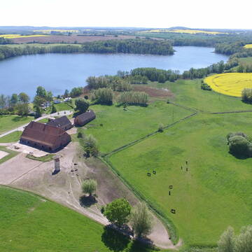
Klein Labenz
L. Zucker
@MTReitanlage
Freizeitstall
Rehabilitationsstall
Führanlage
Hunde willkommen
Allergikerstall
bedampftes/gewaschenes Heu
Außenbox mit Paddock
Außenboxen
30 weitere...
P
Deprecated: Creation of dynamic property Zend_View_Helper_Ads::$adLink is deprecated in /var/www/stall-frei/htdocs/staging.stall-frei.de/library/Psf/View/Helper/Ads.php on line 108

Frisches Stroh zu verkaufen!
Mechtersen
STALL-FREIde Marketing
@STALL-FREI-Marketing
Kaufe frisches Stroh für dein Pferd!
Gut Häven - Pensionsplatz im gepflegten Offensta...
Kloster Tempzin OT Häven
Gut-Haeven
@Gut-Haeven
Fahrstall, Kutschwagen
Freizeitstall
Vermieten
Krankenbox
Longierzirkel/Roundpen
Allergikerstall
Notfallboxen
28 weitere...
P
Leider kein Vorschaubild
Leider kein Vorschaubild
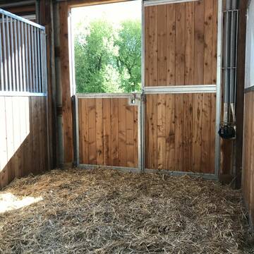
Box frei
Klein Warin
Reitstall-Klein-Warin
@Reitstall-Klein-Warin
Vermieten
Hunde willkommen
Paddock
Einzelne Boxen oder Stallplätze
9 weitere...
ganz aktuell
B


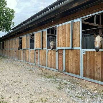
Pensionspferdehaltung bei Schwerin – Komfort pur
Wendorf
Bernsteinreiter
@Bernsteinreiter
FN-Mitglied
Freizeitstall
Vermieten
Führanlage
Hunde willkommen
Hengsthaltung möglich
Pferdezucht
38 weitere...
P+
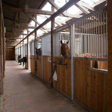
Gut Alt Farpen
Alt Farpen
Gut-Alt-Farpen
@Gut-Alt-Farpen
Freizeitstall
Geländestrecke
Vermieten
Paddock
Pensions- und Gastboxen
Innenbox
11 weitere...
P+
Leider kein Vorschaubild
Leider kein Vorschaubild
Offenstall Frei im Privatstall gleich bei Wismar
Dorf Mecklenburg -Steffin
Hof-Steffin
@Hof-Steffin
Freizeitstall
Vermieten
Verpachten
Krankenbox
Longierzirkel/Roundpen
Allergikerstall
Gnadenbrothof
26 weitere...
B
Leider kein Vorschaubild
Leider kein Vorschaubild
Offenstall Weide Koppel Ganzjährige Wiedehaltung
Dorf Mecklenburg -Steffin
Hof-Steffin
@Hof-Steffin
Freizeitstall
Geländestrecke
Vermieten
Verpachten
Krankenbox
Longierzirkel/Roundpen
Allergikerstall
Gnadenbrothof
33 weitere...
B


Ostseebad-Boltenhagen
Boltenhagen
Reiterhof Boltenhagen
@Reiterhof-Boltenhagen
FN-Mitglied
Freizeitstall
Vermieten
Hunde willkommen
Krankenbox
Außenboxen
26 weitere...
aktuell
S

Persönlichkeitsentwicklung mit Pferden
Bad Salzuflen
Katja Dors
@Pferdezeiten
Begleite andere auf ihrem Entwicklungsweg und entdecke die transformative Kraft der pferdegestützten Persönlichkeitsentwicklung !
neu
R
Leider kein Vorschaubild
Leider kein Vorschaubild
Box frei in kleinem Privatstall
Alt Meteln Ausbau
Pensionsstall Alt Meteln
@Pensionsstall-Alt-Meteln
Freizeitstall
Vermieten
Paddock
Pensions- und Gastboxen
Innenbox
8 weitere...
B
Leider kein Vorschaubild
Leider kein Vorschaubild
Gestüt Neuhof
Neuhof/Poel
Gestuet-Neuhof
@Gestuet-Neuhof
Fahrstall, Kutschwagen
FN-Mitglied
Führanlage
Hunde willkommen
Hengsthaltung möglich
Pferdezucht
Innenbox
Laufbox
23 weitere...
B
Deprecated: Creation of dynamic property Zend_View::$pageCount is deprecated in /var/www/stall-frei/htdocs/staging.stall-frei.de/library/vendor/shardj/zf1-future/library/Zend/View/Abstract.php on line 308
Deprecated: Creation of dynamic property Zend_View::$itemCountPerPage is deprecated in /var/www/stall-frei/htdocs/staging.stall-frei.de/library/vendor/shardj/zf1-future/library/Zend/View/Abstract.php on line 308
Deprecated: Creation of dynamic property Zend_View::$first is deprecated in /var/www/stall-frei/htdocs/staging.stall-frei.de/library/vendor/shardj/zf1-future/library/Zend/View/Abstract.php on line 308
Deprecated: Creation of dynamic property Zend_View::$current is deprecated in /var/www/stall-frei/htdocs/staging.stall-frei.de/library/vendor/shardj/zf1-future/library/Zend/View/Abstract.php on line 308
Deprecated: Creation of dynamic property Zend_View::$last is deprecated in /var/www/stall-frei/htdocs/staging.stall-frei.de/library/vendor/shardj/zf1-future/library/Zend/View/Abstract.php on line 308
Deprecated: Creation of dynamic property Zend_View::$next is deprecated in /var/www/stall-frei/htdocs/staging.stall-frei.de/library/vendor/shardj/zf1-future/library/Zend/View/Abstract.php on line 308
Deprecated: Creation of dynamic property Zend_View::$pagesInRange is deprecated in /var/www/stall-frei/htdocs/staging.stall-frei.de/library/vendor/shardj/zf1-future/library/Zend/View/Abstract.php on line 308
Deprecated: Creation of dynamic property Zend_View::$firstPageInRange is deprecated in /var/www/stall-frei/htdocs/staging.stall-frei.de/library/vendor/shardj/zf1-future/library/Zend/View/Abstract.php on line 308
Deprecated: Creation of dynamic property Zend_View::$lastPageInRange is deprecated in /var/www/stall-frei/htdocs/staging.stall-frei.de/library/vendor/shardj/zf1-future/library/Zend/View/Abstract.php on line 308
Deprecated: Creation of dynamic property Zend_View::$currentItemCount is deprecated in /var/www/stall-frei/htdocs/staging.stall-frei.de/library/vendor/shardj/zf1-future/library/Zend/View/Abstract.php on line 308
Deprecated: Creation of dynamic property Zend_View::$totalItemCount is deprecated in /var/www/stall-frei/htdocs/staging.stall-frei.de/library/vendor/shardj/zf1-future/library/Zend/View/Abstract.php on line 308
Deprecated: Creation of dynamic property Zend_View::$firstItemNumber is deprecated in /var/www/stall-frei/htdocs/staging.stall-frei.de/library/vendor/shardj/zf1-future/library/Zend/View/Abstract.php on line 308
Deprecated: Creation of dynamic property Zend_View::$lastItemNumber is deprecated in /var/www/stall-frei/htdocs/staging.stall-frei.de/library/vendor/shardj/zf1-future/library/Zend/View/Abstract.php on line 308
Deprecated: Creation of dynamic property Zend_View::$router is deprecated in /var/www/stall-frei/htdocs/staging.stall-frei.de/library/vendor/shardj/zf1-future/library/Zend/View/Abstract.php on line 308
Deprecated: Creation of dynamic property Zend_View::$urlParams is deprecated in /var/www/stall-frei/htdocs/staging.stall-frei.de/library/vendor/shardj/zf1-future/library/Zend/View/Abstract.php on line 308
Deprecated: Creation of dynamic property Zend_View::$showAds is deprecated in /var/www/stall-frei/htdocs/staging.stall-frei.de/library/vendor/shardj/zf1-future/library/Zend/View/Abstract.php on line 308
Deprecated: Creation of dynamic property Zend_View::$objectIds is deprecated in /var/www/stall-frei/htdocs/staging.stall-frei.de/library/vendor/shardj/zf1-future/library/Zend/View/Abstract.php on line 308
Deprecated: Creation of dynamic property Zend_View::$showNavbar is deprecated in /var/www/stall-frei/htdocs/staging.stall-frei.de/library/vendor/shardj/zf1-future/library/Zend/View/Abstract.php on line 308
Deprecated: Creation of dynamic property Zend_View::$showBreadcrumb is deprecated in /var/www/stall-frei/htdocs/staging.stall-frei.de/library/vendor/shardj/zf1-future/library/Zend/View/Abstract.php on line 308
Deprecated: Creation of dynamic property Zend_View::$showFooter is deprecated in /var/www/stall-frei/htdocs/staging.stall-frei.de/library/vendor/shardj/zf1-future/library/Zend/View/Abstract.php on line 308
Deprecated: Creation of dynamic property Zend_View::$showInternalAds is deprecated in /var/www/stall-frei/htdocs/staging.stall-frei.de/library/vendor/shardj/zf1-future/library/Zend/View/Abstract.php on line 308
Deprecated: Creation of dynamic property Zend_View::$blNoContent is deprecated in /var/www/stall-frei/htdocs/staging.stall-frei.de/library/vendor/shardj/zf1-future/library/Zend/View/Abstract.php on line 308
Deprecated: Creation of dynamic property Zend_View::$sMetaDesc is deprecated in /var/www/stall-frei/htdocs/staging.stall-frei.de/library/vendor/shardj/zf1-future/library/Zend/View/Abstract.php on line 308
Deprecated: Creation of dynamic property Zend_View::$useGmaps is deprecated in /var/www/stall-frei/htdocs/staging.stall-frei.de/library/vendor/shardj/zf1-future/library/Zend/View/Abstract.php on line 308
Deprecated: Creation of dynamic property Zend_View::$touches is deprecated in /var/www/stall-frei/htdocs/staging.stall-frei.de/library/vendor/shardj/zf1-future/library/Zend/View/Abstract.php on line 308
Deprecated: Creation of dynamic property Zend_View::$oProject is deprecated in /var/www/stall-frei/htdocs/staging.stall-frei.de/library/vendor/shardj/zf1-future/library/Zend/View/Abstract.php on line 308
Deprecated: Creation of dynamic property Zend_View::$pageHeadline is deprecated in /var/www/stall-frei/htdocs/staging.stall-frei.de/library/vendor/shardj/zf1-future/library/Zend/View/Abstract.php on line 308
Deprecated: Creation of dynamic property Zend_View::$disableLocationField is deprecated in /var/www/stall-frei/htdocs/staging.stall-frei.de/library/vendor/shardj/zf1-future/library/Zend/View/Abstract.php on line 308
Deprecated: Creation of dynamic property Zend_View::$isSearch is deprecated in /var/www/stall-frei/htdocs/staging.stall-frei.de/library/vendor/shardj/zf1-future/library/Zend/View/Abstract.php on line 308
Deprecated: Creation of dynamic property Zend_View::$pageTitle is deprecated in /var/www/stall-frei/htdocs/staging.stall-frei.de/library/vendor/shardj/zf1-future/library/Zend/View/Abstract.php on line 308
Deprecated: Creation of dynamic property Psf_Form_Element_Text::$class is deprecated in /var/www/stall-frei/htdocs/staging.stall-frei.de/library/vendor/shardj/zf1-future/library/Zend/Form/Element.php on line 874
Deprecated: Creation of dynamic property Psf_Form_Element_Text::$size is deprecated in /var/www/stall-frei/htdocs/staging.stall-frei.de/library/vendor/shardj/zf1-future/library/Zend/Form/Element.php on line 874
Deprecated: Creation of dynamic property Psf_Form_Element_Text::$placeholder is deprecated in /var/www/stall-frei/htdocs/staging.stall-frei.de/library/vendor/shardj/zf1-future/library/Zend/Form/Element.php on line 874
Deprecated: Creation of dynamic property Psf_Form_Element_Hidden::$class is deprecated in /var/www/stall-frei/htdocs/staging.stall-frei.de/library/vendor/shardj/zf1-future/library/Zend/Form/Element.php on line 874
Deprecated: Creation of dynamic property Psf_Form_Element_Hidden::$class is deprecated in /var/www/stall-frei/htdocs/staging.stall-frei.de/library/vendor/shardj/zf1-future/library/Zend/Form/Element.php on line 874
Deprecated: Creation of dynamic property Psf_Form_Element_Hidden::$class is deprecated in /var/www/stall-frei/htdocs/staging.stall-frei.de/library/vendor/shardj/zf1-future/library/Zend/Form/Element.php on line 874
Deprecated: Creation of dynamic property Psf_Form_Element_Hidden::$class is deprecated in /var/www/stall-frei/htdocs/staging.stall-frei.de/library/vendor/shardj/zf1-future/library/Zend/Form/Element.php on line 874
Deprecated: Creation of dynamic property Psf_Form_Element_Select::$class is deprecated in /var/www/stall-frei/htdocs/staging.stall-frei.de/library/vendor/shardj/zf1-future/library/Zend/Form/Element.php on line 874
Deprecated: Creation of dynamic property Psf_Form_Element_Select::$class is deprecated in /var/www/stall-frei/htdocs/staging.stall-frei.de/library/vendor/shardj/zf1-future/library/Zend/Form/Element.php on line 874
Deprecated: Creation of dynamic property Psf_Form_Element_Select::$class is deprecated in /var/www/stall-frei/htdocs/staging.stall-frei.de/library/vendor/shardj/zf1-future/library/Zend/Form/Element.php on line 874
Deprecated: Creation of dynamic property Psf_Form_Element_Select::$class is deprecated in /var/www/stall-frei/htdocs/staging.stall-frei.de/library/vendor/shardj/zf1-future/library/Zend/Form/Element.php on line 874
Deprecated: Creation of dynamic property Psf_Form_Element_Text::$class is deprecated in /var/www/stall-frei/htdocs/staging.stall-frei.de/library/vendor/shardj/zf1-future/library/Zend/Form/Element.php on line 874
Deprecated: Creation of dynamic property Psf_Form_Element_Checkbox::$label is deprecated in /var/www/stall-frei/htdocs/staging.stall-frei.de/library/vendor/shardj/zf1-future/library/Zend/Form/Element.php on line 874
Deprecated: Creation of dynamic property Zend_View::$sort is deprecated in /var/www/stall-frei/htdocs/staging.stall-frei.de/library/vendor/shardj/zf1-future/library/Zend/View/Abstract.php on line 308
Deprecated: Creation of dynamic property Zend_View::$searchLocation is deprecated in /var/www/stall-frei/htdocs/staging.stall-frei.de/library/vendor/shardj/zf1-future/library/Zend/View/Abstract.php on line 308
Deprecated: Creation of dynamic property Zend_View::$locationHint is deprecated in /var/www/stall-frei/htdocs/staging.stall-frei.de/library/vendor/shardj/zf1-future/library/Zend/View/Abstract.php on line 308
Psf_GeoCoder_Abstract::getLocation: Warin Get Location CachedOrLive
Psf_GeoCoder_Abstract::getCachedOrLive: Warin
Psf_GeoCoder_OpenCageData::makeApiRequest: response:
Array
(
[documentation] => https://opencagedata.com/api
[licenses] => Array
(
[0] => Array
(
[name] => see attribution guide
[url] => https://opencagedata.com/credits
)
)
[results] => Array
(
[0] => Array
(
[bounds] => Array
(
[northeast] => Array
(
[lat] => 53.851611
[lng] => 11.810558
)
[southwest] => Array
(
[lat] => 53.765774
[lng] => 11.6782984
)
)
[components] => Array
(
[ISO_3166-1_alpha-2] => DE
[ISO_3166-1_alpha-3] => DEU
[ISO_3166-2] => Array
(
[0] => DE-MV
)
[_category] => place
[_normalized_city] => Warin
[_type] => city
[continent] => Europe
[country] => Deutschland
[country_code] => de
[county] => Nordwestmecklenburg
[municipality] => Neukloster-Warin
[political_union] => European Union
[postcode] => 19417
[state] => Mecklenburg-Vorpommern
[state_code] => MV
[town] => Warin
)
[confidence] => 7
[formatted] => 19417 Warin, Deutschland
[geometry] => Array
(
[lat] => 53.7998004
[lng] => 11.7043569
)
)
[1] => Array
(
[components] => Array
(
[ISO_3166-1_alpha-2] => GP
[ISO_3166-1_alpha-3] => GLP
[ISO_3166-2] => Array
(
[0] => FR-971
)
[_category] => road
[_normalized_city] => Pointe-Noire
[_type] => road
[city] => Pointe-Noire
[continent] => North America
[country] => France
[country_code] => fr
[county] => Guadeloupe
[local_authority] => Communauté d'agglomération du Nord Basse-Terre
[political_union] => European Union
[postcode] => 97116
[road] => Chemin de Varin
[state] =>
)
[confidence] => 3
[formatted] => Chemin de Varin, 97116 Pointe-Noire, France
[geometry] => Array
(
[lat] => 16.239157
[lng] => -61.786872
)
)
[2] => Array
(
[components] => Array
(
[ISO_3166-1_alpha-2] => GP
[ISO_3166-1_alpha-3] => GLP
[ISO_3166-2] => Array
(
[0] => FR-971
)
[_category] => road
[_normalized_city] => Saint-Louis
[_type] => road
[city] => Saint-Louis
[continent] => North America
[country] => France
[country_code] => fr
[county] => Guadeloupe
[local_authority] => Communauté de communes de Marie-Galante
[political_union] => European Union
[postcode] => 97134
[road] => Chemin de Varin
[state] =>
)
[confidence] => 3
[formatted] => Chemin de Varin, 97134 Saint-Louis, France
[geometry] => Array
(
[lat] => 15.962175
[lng] => -61.31177
)
)
[3] => Array
(
[components] => Array
(
[ISO_3166-1_alpha-2] => FR
[ISO_3166-1_alpha-3] => FRA
[ISO_3166-2] => Array
(
[0] => FR-NOR
[1] => FR-76
)
[_category] => road
[_normalized_city] => Buchy
[_type] => road
[city] => Buchy
[continent] => Europe
[country] => France
[country_code] => fr
[county] => Seine-Maritime
[local_authority] => Communauté de communes Inter-Caux-Vexin
[political_union] => European Union
[postcode] => 76750
[road] => Chemin des Monts Varin
[state] => Normandie
[state_code] => NOR
)
[confidence] => 2
[formatted] => Chemin des Monts Varin, 76750 Buchy, France
[geometry] => Array
(
[lat] => 49.569497
[lng] => 1.390269
)
)
[4] => Array
(
[components] => Array
(
[ISO_3166-1_alpha-2] => FR
[ISO_3166-1_alpha-3] => FRA
[ISO_3166-2] => Array
(
[0] => FR-ARA
[1] => FR-69
)
[_category] => road
[_normalized_city] => Les Haies
[_type] => road
[city] => Les Haies
[continent] => Europe
[country] => France
[country_code] => fr
[county] => Rhône
[local_authority] => Vienne Condrieu Agglomération
[political_union] => European Union
[postcode] => 69420
[road] => Chemin des Varines
[state] => Auvergne-Rhône-Alpes
[state_code] => ARA
)
[confidence] => 2
[formatted] => Chemin des Varines, 69420 Les Haies, France
[geometry] => Array
(
[lat] => 45.503011
[lng] => 4.745726
)
)
[5] => Array
(
[components] => Array
(
[ISO_3166-1_alpha-2] => FR
[ISO_3166-1_alpha-3] => FRA
[ISO_3166-2] => Array
(
[0] => FR-ARA
[1] => FR-01
)
[_category] => road
[_normalized_city] => Miribel
[_type] => road
[city] => Miribel
[continent] => Europe
[country] => France
[country_code] => fr
[county] => Ain
[local_authority] => Communauté de communes de Miribel et du Plateau
[political_union] => European Union
[postcode] => 01700
[road] => Chemin des Varines
[state] => Auvergne-Rhône-Alpes
[state_code] => ARA
)
[confidence] => 2
[formatted] => Chemin des Varines, 01700 Miribel, France
[geometry] => Array
(
[lat] => 45.869302
[lng] => 4.922149
)
)
[6] => Array
(
[components] => Array
(
[ISO_3166-1_alpha-2] => FR
[ISO_3166-1_alpha-3] => FRA
[ISO_3166-2] => Array
(
[0] => FR-ARA
[1] => FR-69
)
[_category] => road
[_normalized_city] => Lentilly
[_type] => road
[city] => Lentilly
[continent] => Europe
[country] => France
[country_code] => fr
[county] => Rhône
[local_authority] => Communauté de communes du Pays de L'Arbresle
[political_union] => European Union
[postcode] => 69210
[road] => Chemin des Varinnes
[state] => Auvergne-Rhône-Alpes
[state_code] => ARA
)
[confidence] => 2
[formatted] => Chemin des Varinnes, 69210 Lentilly, France
[geometry] => Array
(
[lat] => 45.810379
[lng] => 4.662199
)
)
[7] => Array
(
[components] => Array
(
[ISO_3166-1_alpha-2] => FR
[ISO_3166-1_alpha-3] => FRA
[ISO_3166-2] => Array
(
[0] => FR-BFC
[1] => FR-71
)
[_category] => road
[_normalized_city] => Anost
[_type] => road
[city] => Anost
[continent] => Europe
[country] => France
[country_code] => fr
[county] => Saône-et-Loire
[local_authority] => Communauté de communes du Grand Autunois Morvan
[political_union] => European Union
[postcode] => 71550
[road] => Chemin de Varin le Haut
[state] => Bourgogne-Franche-Comté
[state_code] => BFC
)
[confidence] => 2
[formatted] => Chemin de Varin le Haut, 71550 Anost, France
[geometry] => Array
(
[lat] => 47.084504
[lng] => 4.102843
)
)
[8] => Array
(
[components] => Array
(
[ISO_3166-1_alpha-2] => FR
[ISO_3166-1_alpha-3] => FRA
[ISO_3166-2] => Array
(
[0] => FR-ARA
[1] => FR-74
)
[_category] => road
[_normalized_city] => Praz-sur-Arly
[_type] => road
[city] => Praz-sur-Arly
[continent] => Europe
[country] => France
[country_code] => fr
[county] => Haute-Savoie
[local_authority] => Pays du Mont-Blanc
[political_union] => European Union
[postcode] => 74120
[road] => Allée du Plan des Varins
[state] => Auvergne-Rhône-Alpes
[state_code] => ARA
)
[confidence] => 2
[formatted] => Allée du Plan des Varins, 74120 Praz-sur-Arly, France
[geometry] => Array
(
[lat] => 45.833715
[lng] => 6.575265
)
)
[9] => Array
(
[components] => Array
(
[ISO_3166-1_alpha-2] => FR
[ISO_3166-1_alpha-3] => FRA
[ISO_3166-2] => Array
(
[0] => FR-NOR
[1] => FR-14
)
[_category] => road
[_normalized_city] => Beaufour-Druval
[_type] => road
[city] => Beaufour-Druval
[continent] => Europe
[country] => France
[country_code] => fr
[county] => Calvados
[local_authority] => Communauté de communes Normandie-Cabourg-Pays d'Auge
[political_union] => European Union
[postcode] => 14340
[road] => Chemin de la Cour Varin
[state] => Normandie
[state_code] => NOR
)
[confidence] => 2
[formatted] => Chemin de la Cour Varin, 14340 Beaufour-Druval, France
[geometry] => Array
(
[lat] => 49.217418
[lng] => 0.032325
)
)
)
[status] => Array
(
[code] => 200
[message] => OK
)
[stay_informed] => Array
(
[blog] => https://blog.opencagedata.com
[mastodon] => https://en.osm.town/@opencage
)
[thanks] => For using an OpenCage API
[timestamp] => Array
(
[created_http] => Sun, 08 Feb 2026 03:28:09 GMT
[created_unix] => 1770521289
)
[total_results] => 10
)
Psf_GeoCoder_Abstract::convertLocationResult
{"documentation":"https:\/\/opencagedata.com\/api","licenses":[{"name":"see attribution guide","url":"https:\/\/opencagedata.com\/credits"}],"results":[{"bounds":{"northeast":{"lat":53.851611,"lng":11.810558},"southwest":{"lat":53.765774,"lng":11.6782984}},"components":{"ISO_3166-1_alpha-2":"DE","ISO_3166-1_alpha-3":"DEU","ISO_3166-2":["DE-MV"],"_category":"place","_normalized_city":"Warin","_type":"city","continent":"Europe","country":"Deutschland","country_code":"de","county":"Nordwestmecklenburg","municipality":"Neukloster-Warin","political_union":"European Union","postcode":"19417","state":"Mecklenburg-Vorpommern","state_code":"MV","town":"Warin"},"confidence":7,"formatted":"19417 Warin, Deutschland","geometry":{"lat":53.7998004,"lng":11.7043569}},{"components":{"ISO_3166-1_alpha-2":"GP","ISO_3166-1_alpha-3":"GLP","ISO_3166-2":["FR-971"],"_category":"road","_normalized_city":"Pointe-Noire","_type":"road","city":"Pointe-Noire","continent":"North America","country":"France","country_code":"fr","county":"Guadeloupe","local_authority":"Communaut\u00e9 d'agglom\u00e9ration du Nord Basse-Terre","political_union":"European Union","postcode":"97116","road":"Chemin de Varin","state":null},"confidence":3,"formatted":"Chemin de Varin, 97116 Pointe-Noire, France","geometry":{"lat":16.239157,"lng":-61.786872}},{"components":{"ISO_3166-1_alpha-2":"GP","ISO_3166-1_alpha-3":"GLP","ISO_3166-2":["FR-971"],"_category":"road","_normalized_city":"Saint-Louis","_type":"road","city":"Saint-Louis","continent":"North America","country":"France","country_code":"fr","county":"Guadeloupe","local_authority":"Communaut\u00e9 de communes de Marie-Galante","political_union":"European Union","postcode":"97134","road":"Chemin de Varin","state":null},"confidence":3,"formatted":"Chemin de Varin, 97134 Saint-Louis, France","geometry":{"lat":15.962175,"lng":-61.31177}},{"components":{"ISO_3166-1_alpha-2":"FR","ISO_3166-1_alpha-3":"FRA","ISO_3166-2":["FR-NOR","FR-76"],"_category":"road","_normalized_city":"Buchy","_type":"road","city":"Buchy","continent":"Europe","country":"France","country_code":"fr","county":"Seine-Maritime","local_authority":"Communaut\u00e9 de communes Inter-Caux-Vexin","political_union":"European Union","postcode":"76750","road":"Chemin des Monts Varin","state":"Normandie","state_code":"NOR"},"confidence":2,"formatted":"Chemin des Monts Varin, 76750 Buchy, France","geometry":{"lat":49.569497,"lng":1.390269}},{"components":{"ISO_3166-1_alpha-2":"FR","ISO_3166-1_alpha-3":"FRA","ISO_3166-2":["FR-ARA","FR-69"],"_category":"road","_normalized_city":"Les Haies","_type":"road","city":"Les Haies","continent":"Europe","country":"France","country_code":"fr","county":"Rh\u00f4ne","local_authority":"Vienne Condrieu Agglom\u00e9ration","political_union":"European Union","postcode":"69420","road":"Chemin des Varines","state":"Auvergne-Rh\u00f4ne-Alpes","state_code":"ARA"},"confidence":2,"formatted":"Chemin des Varines, 69420 Les Haies, France","geometry":{"lat":45.503011,"lng":4.745726}},{"components":{"ISO_3166-1_alpha-2":"FR","ISO_3166-1_alpha-3":"FRA","ISO_3166-2":["FR-ARA","FR-01"],"_category":"road","_normalized_city":"Miribel","_type":"road","city":"Miribel","continent":"Europe","country":"France","country_code":"fr","county":"Ain","local_authority":"Communaut\u00e9 de communes de Miribel et du Plateau","political_union":"European Union","postcode":"01700","road":"Chemin des Varines","state":"Auvergne-Rh\u00f4ne-Alpes","state_code":"ARA"},"confidence":2,"formatted":"Chemin des Varines, 01700 Miribel, France","geometry":{"lat":45.869302,"lng":4.922149}},{"components":{"ISO_3166-1_alpha-2":"FR","ISO_3166-1_alpha-3":"FRA","ISO_3166-2":["FR-ARA","FR-69"],"_category":"road","_normalized_city":"Lentilly","_type":"road","city":"Lentilly","continent":"Europe","country":"France","country_code":"fr","county":"Rh\u00f4ne","local_authority":"Communaut\u00e9 de communes du Pays de L'Arbresle","political_union":"European Union","postcode":"69210","road":"Chemin des Varinnes","state":"Auvergne-Rh\u00f4ne-Alpes","state_code":"ARA"},"confidence":2,"formatted":"Chemin des Varinnes, 69210 Lentilly, France","geometry":{"lat":45.810379,"lng":4.662199}},{"components":{"ISO_3166-1_alpha-2":"FR","ISO_3166-1_alpha-3":"FRA","ISO_3166-2":["FR-BFC","FR-71"],"_category":"road","_normalized_city":"Anost","_type":"road","city":"Anost","continent":"Europe","country":"France","country_code":"fr","county":"Sa\u00f4ne-et-Loire","local_authority":"Communaut\u00e9 de communes du Grand Autunois Morvan","political_union":"European Union","postcode":"71550","road":"Chemin de Varin le Haut","state":"Bourgogne-Franche-Comt\u00e9","state_code":"BFC"},"confidence":2,"formatted":"Chemin de Varin le Haut, 71550 Anost, France","geometry":{"lat":47.084504,"lng":4.102843}},{"components":{"ISO_3166-1_alpha-2":"FR","ISO_3166-1_alpha-3":"FRA","ISO_3166-2":["FR-ARA","FR-74"],"_category":"road","_normalized_city":"Praz-sur-Arly","_type":"road","city":"Praz-sur-Arly","continent":"Europe","country":"France","country_code":"fr","county":"Haute-Savoie","local_authority":"Pays du Mont-Blanc","political_union":"European Union","postcode":"74120","road":"All\u00e9e du Plan des Varins","state":"Auvergne-Rh\u00f4ne-Alpes","state_code":"ARA"},"confidence":2,"formatted":"All\u00e9e du Plan des Varins, 74120 Praz-sur-Arly, France","geometry":{"lat":45.833715,"lng":6.575265}},{"components":{"ISO_3166-1_alpha-2":"FR","ISO_3166-1_alpha-3":"FRA","ISO_3166-2":["FR-NOR","FR-14"],"_category":"road","_normalized_city":"Beaufour-Druval","_type":"road","city":"Beaufour-Druval","continent":"Europe","country":"France","country_code":"fr","county":"Calvados","local_authority":"Communaut\u00e9 de communes Normandie-Cabourg-Pays d'Auge","political_union":"European Union","postcode":"14340","road":"Chemin de la Cour Varin","state":"Normandie","state_code":"NOR"},"confidence":2,"formatted":"Chemin de la Cour Varin, 14340 Beaufour-Druval, France","geometry":{"lat":49.217418,"lng":0.032325}}],"status":{"code":200,"message":"OK"},"stay_informed":{"blog":"https:\/\/blog.opencagedata.com","mastodon":"https:\/\/en.osm.town\/@opencage"},"thanks":"For using an OpenCage API","timestamp":{"created_http":"Sun, 08 Feb 2026 03:28:09 GMT","created_unix":1770521289},"total_results":10}Array
(
[0] => stdClass Object
(
[bounds] => stdClass Object
(
[northeast] => stdClass Object
(
[lat] => 53.851611
[lng] => 11.810558
)
[southwest] => stdClass Object
(
[lat] => 53.765774
[lng] => 11.6782984
)
)
[components] => stdClass Object
(
[ISO_3166-1_alpha-2] => DE
[ISO_3166-1_alpha-3] => DEU
[ISO_3166-2] => Array
(
[0] => DE-MV
)
[_category] => place
[_normalized_city] => Warin
[_type] => city
[continent] => Europe
[country] => Deutschland
[country_code] => de
[county] => Nordwestmecklenburg
[municipality] => Neukloster-Warin
[political_union] => European Union
[postcode] => 19417
[state] => Mecklenburg-Vorpommern
[state_code] => MV
[town] => Warin
)
[confidence] => 7
[formatted] => 19417 Warin, Deutschland
[geometry] => stdClass Object
(
[lat] => 53.7998004
[lng] => 11.7043569
)
)
[1] => stdClass Object
(
[components] => stdClass Object
(
[ISO_3166-1_alpha-2] => GP
[ISO_3166-1_alpha-3] => GLP
[ISO_3166-2] => Array
(
[0] => FR-971
)
[_category] => road
[_normalized_city] => Pointe-Noire
[_type] => road
[city] => Pointe-Noire
[continent] => North America
[country] => France
[country_code] => fr
[county] => Guadeloupe
[local_authority] => Communauté d'agglomération du Nord Basse-Terre
[political_union] => European Union
[postcode] => 97116
[road] => Chemin de Varin
[state] =>
)
[confidence] => 3
[formatted] => Chemin de Varin, 97116 Pointe-Noire, France
[geometry] => stdClass Object
(
[lat] => 16.239157
[lng] => -61.786872
)
)
[2] => stdClass Object
(
[components] => stdClass Object
(
[ISO_3166-1_alpha-2] => GP
[ISO_3166-1_alpha-3] => GLP
[ISO_3166-2] => Array
(
[0] => FR-971
)
[_category] => road
[_normalized_city] => Saint-Louis
[_type] => road
[city] => Saint-Louis
[continent] => North America
[country] => France
[country_code] => fr
[county] => Guadeloupe
[local_authority] => Communauté de communes de Marie-Galante
[political_union] => European Union
[postcode] => 97134
[road] => Chemin de Varin
[state] =>
)
[confidence] => 3
[formatted] => Chemin de Varin, 97134 Saint-Louis, France
[geometry] => stdClass Object
(
[lat] => 15.962175
[lng] => -61.31177
)
)
[3] => stdClass Object
(
[components] => stdClass Object
(
[ISO_3166-1_alpha-2] => FR
[ISO_3166-1_alpha-3] => FRA
[ISO_3166-2] => Array
(
[0] => FR-NOR
[1] => FR-76
)
[_category] => road
[_normalized_city] => Buchy
[_type] => road
[city] => Buchy
[continent] => Europe
[country] => France
[country_code] => fr
[county] => Seine-Maritime
[local_authority] => Communauté de communes Inter-Caux-Vexin
[political_union] => European Union
[postcode] => 76750
[road] => Chemin des Monts Varin
[state] => Normandie
[state_code] => NOR
)
[confidence] => 2
[formatted] => Chemin des Monts Varin, 76750 Buchy, France
[geometry] => stdClass Object
(
[lat] => 49.569497
[lng] => 1.390269
)
)
[4] => stdClass Object
(
[components] => stdClass Object
(
[ISO_3166-1_alpha-2] => FR
[ISO_3166-1_alpha-3] => FRA
[ISO_3166-2] => Array
(
[0] => FR-ARA
[1] => FR-69
)
[_category] => road
[_normalized_city] => Les Haies
[_type] => road
[city] => Les Haies
[continent] => Europe
[country] => France
[country_code] => fr
[county] => Rhône
[local_authority] => Vienne Condrieu Agglomération
[political_union] => European Union
[postcode] => 69420
[road] => Chemin des Varines
[state] => Auvergne-Rhône-Alpes
[state_code] => ARA
)
[confidence] => 2
[formatted] => Chemin des Varines, 69420 Les Haies, France
[geometry] => stdClass Object
(
[lat] => 45.503011
[lng] => 4.745726
)
)
[5] => stdClass Object
(
[components] => stdClass Object
(
[ISO_3166-1_alpha-2] => FR
[ISO_3166-1_alpha-3] => FRA
[ISO_3166-2] => Array
(
[0] => FR-ARA
[1] => FR-01
)
[_category] => road
[_normalized_city] => Miribel
[_type] => road
[city] => Miribel
[continent] => Europe
[country] => France
[country_code] => fr
[county] => Ain
[local_authority] => Communauté de communes de Miribel et du Plateau
[political_union] => European Union
[postcode] => 01700
[road] => Chemin des Varines
[state] => Auvergne-Rhône-Alpes
[state_code] => ARA
)
[confidence] => 2
[formatted] => Chemin des Varines, 01700 Miribel, France
[geometry] => stdClass Object
(
[lat] => 45.869302
[lng] => 4.922149
)
)
[6] => stdClass Object
(
[components] => stdClass Object
(
[ISO_3166-1_alpha-2] => FR
[ISO_3166-1_alpha-3] => FRA
[ISO_3166-2] => Array
(
[0] => FR-ARA
[1] => FR-69
)
[_category] => road
[_normalized_city] => Lentilly
[_type] => road
[city] => Lentilly
[continent] => Europe
[country] => France
[country_code] => fr
[county] => Rhône
[local_authority] => Communauté de communes du Pays de L'Arbresle
[political_union] => European Union
[postcode] => 69210
[road] => Chemin des Varinnes
[state] => Auvergne-Rhône-Alpes
[state_code] => ARA
)
[confidence] => 2
[formatted] => Chemin des Varinnes, 69210 Lentilly, France
[geometry] => stdClass Object
(
[lat] => 45.810379
[lng] => 4.662199
)
)
[7] => stdClass Object
(
[components] => stdClass Object
(
[ISO_3166-1_alpha-2] => FR
[ISO_3166-1_alpha-3] => FRA
[ISO_3166-2] => Array
(
[0] => FR-BFC
[1] => FR-71
)
[_category] => road
[_normalized_city] => Anost
[_type] => road
[city] => Anost
[continent] => Europe
[country] => France
[country_code] => fr
[county] => Saône-et-Loire
[local_authority] => Communauté de communes du Grand Autunois Morvan
[political_union] => European Union
[postcode] => 71550
[road] => Chemin de Varin le Haut
[state] => Bourgogne-Franche-Comté
[state_code] => BFC
)
[confidence] => 2
[formatted] => Chemin de Varin le Haut, 71550 Anost, France
[geometry] => stdClass Object
(
[lat] => 47.084504
[lng] => 4.102843
)
)
[8] => stdClass Object
(
[components] => stdClass Object
(
[ISO_3166-1_alpha-2] => FR
[ISO_3166-1_alpha-3] => FRA
[ISO_3166-2] => Array
(
[0] => FR-ARA
[1] => FR-74
)
[_category] => road
[_normalized_city] => Praz-sur-Arly
[_type] => road
[city] => Praz-sur-Arly
[continent] => Europe
[country] => France
[country_code] => fr
[county] => Haute-Savoie
[local_authority] => Pays du Mont-Blanc
[political_union] => European Union
[postcode] => 74120
[road] => Allée du Plan des Varins
[state] => Auvergne-Rhône-Alpes
[state_code] => ARA
)
[confidence] => 2
[formatted] => Allée du Plan des Varins, 74120 Praz-sur-Arly, France
[geometry] => stdClass Object
(
[lat] => 45.833715
[lng] => 6.575265
)
)
[9] => stdClass Object
(
[components] => stdClass Object
(
[ISO_3166-1_alpha-2] => FR
[ISO_3166-1_alpha-3] => FRA
[ISO_3166-2] => Array
(
[0] => FR-NOR
[1] => FR-14
)
[_category] => road
[_normalized_city] => Beaufour-Druval
[_type] => road
[city] => Beaufour-Druval
[continent] => Europe
[country] => France
[country_code] => fr
[county] => Calvados
[local_authority] => Communauté de communes Normandie-Cabourg-Pays d'Auge
[political_union] => European Union
[postcode] => 14340
[road] => Chemin de la Cour Varin
[state] => Normandie
[state_code] => NOR
)
[confidence] => 2
[formatted] => Chemin de la Cour Varin, 14340 Beaufour-Druval, France
[geometry] => stdClass Object
(
[lat] => 49.217418
[lng] => 0.032325
)
)
)
Psf_GeoCoder_OpenCageData::getKeyMap: 0
stdClass Object
(
    [bounds] => stdClass Object
        (
            [northeast] => stdClass Object
                (
                    [lat] => 53.851611
                    [lng] => 11.810558
                )

            [southwest] => stdClass Object
                (
                    [lat] => 53.765774
                    [lng] => 11.6782984
                )

        )

    [components] => stdClass Object
        (
            [ISO_3166-1_alpha-2] => DE
            [ISO_3166-1_alpha-3] => DEU
            [ISO_3166-2] => Array
                (
                    [0] => DE-MV
                )

            [_category] => place
            [_normalized_city] => Warin
            [_type] => city
            [continent] => Europe
            [country] => Deutschland
            [country_code] => de
            [county] => Nordwestmecklenburg
            [municipality] => Neukloster-Warin
            [political_union] => European Union
            [postcode] => 19417
            [state] => Mecklenburg-Vorpommern
            [state_code] => MV
            [town] => Warin
        )

    [confidence] => 7
    [formatted] => 19417 Warin, Deutschland
    [geometry] => stdClass Object
        (
            [lat] => 53.7998004
            [lng] => 11.7043569
        )

)
Psf_GeoCoder_OpenCageData::getCounty: Nordwestmecklenburg
Psf_GeoCoder_OpenCageData::addMissingData REFETCH!
Array
(
    [address] => 19417 Warin, Deutschland
    [type] => city
    [street] =>
    [city] => Warin
    [county] => Nordwestmecklenburg
    [state] => Mecklenburg-Vorpommern
    [zip] => 19417
    [country] => Deutschland
    [suburb] =>
    [countrycode] => de
    [latitude] => 53.7998004
    [longitude] => 11.7043569
    [accuracy] => 1
    [confidence] => 7
    [bounds] => stdClass Object
        (
            [northeast] => stdClass Object
                (
                    [lat] => 53.851611
                    [lng] => 11.810558
                )

            [southwest] => stdClass Object
                (
                    [lat] => 53.765774
                    [lng] => 11.6782984
                )

        )

)
reformat!
Array
(
    [address] => 19417 Warin, Deutschland
    [type] => city
    [street] =>
    [city] => Warin
    [county] => Nordwestmecklenburg
    [state] => Mecklenburg-Vorpommern
    [zip] => 19417
    [country] => Deutschland
    [suburb] =>
    [countrycode] => de
    [latitude] => 53.7998004
    [longitude] => 11.7043569
    [accuracy] => 1
    [confidence] => 7
    [bounds] => stdClass Object
        (
            [northeast] => stdClass Object
                (
                    [lat] => 53.851611
                    [lng] => 11.810558
                )

            [southwest] => stdClass Object
                (
                    [lat] => 53.765774
                    [lng] => 11.6782984
                )

        )

    [place] => 19417 Warin, Mecklenburg-Vorpommern
    [hash] => 09d703ecb136a6451d6fa1d67a097eb7
)
Psf_GeoCoder_OpenCageData::getKeyMap: 1
stdClass Object
(
    [components] => stdClass Object
        (
            [ISO_3166-1_alpha-2] => GP
            [ISO_3166-1_alpha-3] => GLP
            [ISO_3166-2] => Array
                (
                    [0] => FR-971
                )

            [_category] => road
            [_normalized_city] => Pointe-Noire
            [_type] => road
            [city] => Pointe-Noire
            [continent] => North America
            [country] => France
            [country_code] => fr
            [county] => Guadeloupe
            [local_authority] => Communauté d'agglomération du Nord Basse-Terre
            [political_union] => European Union
            [postcode] => 97116
            [road] => Chemin de Varin
            [state] =>
        )

    [confidence] => 3
    [formatted] => Chemin de Varin, 97116 Pointe-Noire, France
    [geometry] => stdClass Object
        (
            [lat] => 16.239157
            [lng] => -61.786872
        )

)
Psf_GeoCoder_OpenCageData::getCounty: Guadeloupe
Psf_GeoCoder_OpenCageData::addMissingData REFETCH!
Array
(
    [address] => Chemin de Varin, 97116 Pointe-Noire, France
    [type] => road
    [street] => Chemin de Varin
    [city] => Pointe-Noire
    [county] => Guadeloupe
    [state] =>
    [zip] => 97116
    [country] => France
    [suburb] =>
    [countrycode] => fr
    [latitude] => 16.239157
    [longitude] => -61.786872
    [accuracy] => 1
    [confidence] => 3
    [bounds] =>
)
reformat!
Array
(
    [address] => Chemin de Varin, 97116 Pointe-Noire, France
    [type] => road
    [street] => Chemin de Varin
    [city] => Pointe-Noire
    [county] => Guadeloupe
    [state] =>
    [zip] => 97116
    [country] => France
    [suburb] =>
    [countrycode] => fr
    [latitude] => 16.239157
    [longitude] => -61.786872
    [accuracy] => 1
    [confidence] => 3
    [bounds] =>
    [place] => Chemin de Varin, 97116 Pointe-Noire, France
    [hash] => 2fef3f0c0c72f3976794358cb063b74a
)
Psf_GeoCoder_OpenCageData::getKeyMap: 2
stdClass Object
(
    [components] => stdClass Object
        (
            [ISO_3166-1_alpha-2] => GP
            [ISO_3166-1_alpha-3] => GLP
            [ISO_3166-2] => Array
                (
                    [0] => FR-971
                )

            [_category] => road
            [_normalized_city] => Saint-Louis
            [_type] => road
            [city] => Saint-Louis
            [continent] => North America
            [country] => France
            [country_code] => fr
            [county] => Guadeloupe
            [local_authority] => Communauté de communes de Marie-Galante
            [political_union] => European Union
            [postcode] => 97134
            [road] => Chemin de Varin
            [state] =>
        )

    [confidence] => 3
    [formatted] => Chemin de Varin, 97134 Saint-Louis, France
    [geometry] => stdClass Object
        (
            [lat] => 15.962175
            [lng] => -61.31177
        )

)
Psf_GeoCoder_OpenCageData::getCounty: Guadeloupe
Psf_GeoCoder_OpenCageData::addMissingData REFETCH!
Array
(
    [address] => Chemin de Varin, 97134 Saint-Louis, France
    [type] => road
    [street] => Chemin de Varin
    [city] => Saint-Louis
    [county] => Guadeloupe
    [state] =>
    [zip] => 97134
    [country] => France
    [suburb] =>
    [countrycode] => fr
    [latitude] => 15.962175
    [longitude] => -61.31177
    [accuracy] => 1
    [confidence] => 3
    [bounds] =>
)
reformat!
Array
(
    [address] => Chemin de Varin, 97134 Saint-Louis, France
    [type] => road
    [street] => Chemin de Varin
    [city] => Saint-Louis
    [county] => Guadeloupe
    [state] =>
    [zip] => 97134
    [country] => France
    [suburb] =>
    [countrycode] => fr
    [latitude] => 15.962175
    [longitude] => -61.31177
    [accuracy] => 1
    [confidence] => 3
    [bounds] =>
    [place] => Chemin de Varin, 97134 Saint-Louis, France
    [hash] => 8369678f54e125e3c3d7bfa5b073c30a
)
Psf_GeoCoder_OpenCageData::getKeyMap: 3
stdClass Object
(
    [components] => stdClass Object
        (
            [ISO_3166-1_alpha-2] => FR
            [ISO_3166-1_alpha-3] => FRA
            [ISO_3166-2] => Array
                (
                    [0] => FR-NOR
                    [1] => FR-76
                )

            [_category] => road
            [_normalized_city] => Buchy
            [_type] => road
            [city] => Buchy
            [continent] => Europe
            [country] => France
            [country_code] => fr
            [county] => Seine-Maritime
            [local_authority] => Communauté de communes Inter-Caux-Vexin
            [political_union] => European Union
            [postcode] => 76750
            [road] => Chemin des Monts Varin
            [state] => Normandie
            [state_code] => NOR
        )

    [confidence] => 2
    [formatted] => Chemin des Monts Varin, 76750 Buchy, France
    [geometry] => stdClass Object
        (
            [lat] => 49.569497
            [lng] => 1.390269
        )

)
Psf_GeoCoder_OpenCageData::getCounty: Seine-Maritime
Psf_GeoCoder_OpenCageData::addMissingData REFETCH!
Array
(
    [address] => Chemin des Monts Varin, 76750 Buchy, France
    [type] => road
    [street] => Chemin des Monts Varin
    [city] => Buchy
    [county] => Seine-Maritime
    [state] => Normandie
    [zip] => 76750
    [country] => France
    [suburb] =>
    [countrycode] => fr
    [latitude] => 49.569497
    [longitude] => 1.390269
    [accuracy] => 1
    [confidence] => 2
    [bounds] =>
)
reformat!
Array
(
    [address] => Chemin des Monts Varin, 76750 Buchy, France
    [type] => road
    [street] => Chemin des Monts Varin
    [city] => Buchy
    [county] => Seine-Maritime
    [state] => Normandie
    [zip] => 76750
    [country] => France
    [suburb] =>
    [countrycode] => fr
    [latitude] => 49.569497
    [longitude] => 1.390269
    [accuracy] => 1
    [confidence] => 2
    [bounds] =>
    [place] => Chemin des Monts Varin, 76750 Buchy, Normandie
    [hash] => f5a2c2908e60a4d21605b8e45e8c4071
)
Psf_GeoCoder_OpenCageData::getKeyMap: 4
stdClass Object
(
    [components] => stdClass Object
        (
            [ISO_3166-1_alpha-2] => FR
            [ISO_3166-1_alpha-3] => FRA
            [ISO_3166-2] => Array
                (
                    [0] => FR-ARA
                    [1] => FR-69
                )

            [_category] => road
            [_normalized_city] => Les Haies
            [_type] => road
            [city] => Les Haies
            [continent] => Europe
            [country] => France
            [country_code] => fr
            [county] => Rhône
            [local_authority] => Vienne Condrieu Agglomération
            [political_union] => European Union
            [postcode] => 69420
            [road] => Chemin des Varines
            [state] => Auvergne-Rhône-Alpes
            [state_code] => ARA
        )

    [confidence] => 2
    [formatted] => Chemin des Varines, 69420 Les Haies, France
    [geometry] => stdClass Object
        (
            [lat] => 45.503011
            [lng] => 4.745726
        )

)
Psf_GeoCoder_OpenCageData::getCounty: Rhône
Psf_GeoCoder_OpenCageData::addMissingData REFETCH!
Array
(
    [address] => Chemin des Varines, 69420 Les Haies, France
    [type] => road
    [street] => Chemin des Varines
    [city] => Les Haies
    [county] => Rhône
    [state] => Auvergne-Rhône-Alpes
    [zip] => 69420
    [country] => France
    [suburb] =>
    [countrycode] => fr
    [latitude] => 45.503011
    [longitude] => 4.745726
    [accuracy] => 1
    [confidence] => 2
    [bounds] =>
)
reformat!
Array
(
    [address] => Chemin des Varines, 69420 Les Haies, France
    [type] => road
    [street] => Chemin des Varines
    [city] => Les Haies
    [county] => Rhône
    [state] => Auvergne-Rhône-Alpes
    [zip] => 69420
    [country] => France
    [suburb] =>
    [countrycode] => fr
    [latitude] => 45.503011
    [longitude] => 4.745726
    [accuracy] => 1
    [confidence] => 2
    [bounds] =>
    [place] => Chemin des Varines, 69420 Les Haies, Auvergne-Rhône-Alpes
    [hash] => 5c6992a14a4b88dcedb408c82112f2ec
)
Psf_GeoCoder_OpenCageData::getKeyMap: 5
stdClass Object
(
    [components] => stdClass Object
        (
            [ISO_3166-1_alpha-2] => FR
            [ISO_3166-1_alpha-3] => FRA
            [ISO_3166-2] => Array
                (
                    [0] => FR-ARA
                    [1] => FR-01
                )

            [_category] => road
            [_normalized_city] => Miribel
            [_type] => road
            [city] => Miribel
            [continent] => Europe
            [country] => France
            [country_code] => fr
            [county] => Ain
            [local_authority] => Communauté de communes de Miribel et du Plateau
            [political_union] => European Union
            [postcode] => 01700
            [road] => Chemin des Varines
            [state] => Auvergne-Rhône-Alpes
            [state_code] => ARA
        )

    [confidence] => 2
    [formatted] => Chemin des Varines, 01700 Miribel, France
    [geometry] => stdClass Object
        (
            [lat] => 45.869302
            [lng] => 4.922149
        )

)
Psf_GeoCoder_OpenCageData::getCounty: Ain
Psf_GeoCoder_OpenCageData::addMissingData REFETCH!
Array
(
    [address] => Chemin des Varines, 01700 Miribel, France
    [type] => road
    [street] => Chemin des Varines
    [city] => Miribel
    [county] => Ain
    [state] => Auvergne-Rhône-Alpes
    [zip] => 01700
    [country] => France
    [suburb] =>
    [countrycode] => fr
    [latitude] => 45.869302
    [longitude] => 4.922149
    [accuracy] => 1
    [confidence] => 2
    [bounds] =>
)
reformat!
Array
(
    [address] => Chemin des Varines, 01700 Miribel, France
    [type] => road
    [street] => Chemin des Varines
    [city] => Miribel
    [county] => Ain
    [state] => Auvergne-Rhône-Alpes
    [zip] => 01700
    [country] => France
    [suburb] =>
    [countrycode] => fr
    [latitude] => 45.869302
    [longitude] => 4.922149
    [accuracy] => 1
    [confidence] => 2
    [bounds] =>
    [place] => Chemin des Varines, 01700 Miribel, Auvergne-Rhône-Alpes
    [hash] => 95c17df953ffc240896fde720b94de5b
)
Psf_GeoCoder_OpenCageData::getKeyMap: 6
stdClass Object
(
    [components] => stdClass Object
        (
            [ISO_3166-1_alpha-2] => FR
            [ISO_3166-1_alpha-3] => FRA
            [ISO_3166-2] => Array
                (
                    [0] => FR-ARA
                    [1] => FR-69
                )

            [_category] => road
            [_normalized_city] => Lentilly
            [_type] => road
            [city] => Lentilly
            [continent] => Europe
            [country] => France
            [country_code] => fr
            [county] => Rhône
            [local_authority] => Communauté de communes du Pays de L'Arbresle
            [political_union] => European Union
            [postcode] => 69210
            [road] => Chemin des Varinnes
            [state] => Auvergne-Rhône-Alpes
            [state_code] => ARA
        )

    [confidence] => 2
    [formatted] => Chemin des Varinnes, 69210 Lentilly, France
    [geometry] => stdClass Object
        (
            [lat] => 45.810379
            [lng] => 4.662199
        )

)
Psf_GeoCoder_OpenCageData::getCounty: Rhône
Psf_GeoCoder_OpenCageData::addMissingData REFETCH!
Array
(
    [address] => Chemin des Varinnes, 69210 Lentilly, France
    [type] => road
    [street] => Chemin des Varinnes
    [city] => Lentilly
    [county] => Rhône
    [state] => Auvergne-Rhône-Alpes
    [zip] => 69210
    [country] => France
    [suburb] =>
    [countrycode] => fr
    [latitude] => 45.810379
    [longitude] => 4.662199
    [accuracy] => 1
    [confidence] => 2
    [bounds] =>
)
reformat!
Array
(
    [address] => Chemin des Varinnes, 69210 Lentilly, France
    [type] => road
    [street] => Chemin des Varinnes
    [city] => Lentilly
    [county] => Rhône
    [state] => Auvergne-Rhône-Alpes
    [zip] => 69210
    [country] => France
    [suburb] =>
    [countrycode] => fr
    [latitude] => 45.810379
    [longitude] => 4.662199
    [accuracy] => 1
    [confidence] => 2
    [bounds] =>
    [place] => Chemin des Varinnes, 69210 Lentilly, Auvergne-Rhône-Alpes
    [hash] => 67819cb045d989c64af42ff8ab8e389a
)
Psf_GeoCoder_OpenCageData::getKeyMap: 7
stdClass Object
(
    [components] => stdClass Object
        (
            [ISO_3166-1_alpha-2] => FR
            [ISO_3166-1_alpha-3] => FRA
            [ISO_3166-2] => Array
                (
                    [0] => FR-BFC
                    [1] => FR-71
                )

            [_category] => road
            [_normalized_city] => Anost
            [_type] => road
            [city] => Anost
            [continent] => Europe
            [country] => France
            [country_code] => fr
            [county] => Saône-et-Loire
            [local_authority] => Communauté de communes du Grand Autunois Morvan
            [political_union] => European Union
            [postcode] => 71550
            [road] => Chemin de Varin le Haut
            [state] => Bourgogne-Franche-Comté
            [state_code] => BFC
        )

    [confidence] => 2
    [formatted] => Chemin de Varin le Haut, 71550 Anost, France
    [geometry] => stdClass Object
        (
            [lat] => 47.084504
            [lng] => 4.102843
        )

)
Psf_GeoCoder_OpenCageData::getCounty: Saône-et-Loire
Psf_GeoCoder_OpenCageData::addMissingData REFETCH!
Array
(
    [address] => Chemin de Varin le Haut, 71550 Anost, France
    [type] => road
    [street] => Chemin de Varin le Haut
    [city] => Anost
    [county] => Saône-et-Loire
    [state] => Bourgogne-Franche-Comté
    [zip] => 71550
    [country] => France
    [suburb] =>
    [countrycode] => fr
    [latitude] => 47.084504
    [longitude] => 4.102843
    [accuracy] => 1
    [confidence] => 2
    [bounds] =>
)
reformat!
Array
(
    [address] => Chemin de Varin le Haut, 71550 Anost, France
    [type] => road
    [street] => Chemin de Varin le Haut
    [city] => Anost
    [county] => Saône-et-Loire
    [state] => Bourgogne-Franche-Comté
    [zip] => 71550
    [country] => France
    [suburb] =>
    [countrycode] => fr
    [latitude] => 47.084504
    [longitude] => 4.102843
    [accuracy] => 1
    [confidence] => 2
    [bounds] =>
    [place] => Chemin de Varin le Haut, 71550 Anost, Bourgogne-Franche-Comté
    [hash] => 257e02527a4108552ae4afae616a6e3c
)
Psf_GeoCoder_OpenCageData::getKeyMap: 8
stdClass Object
(
    [components] => stdClass Object
        (
            [ISO_3166-1_alpha-2] => FR
            [ISO_3166-1_alpha-3] => FRA
            [ISO_3166-2] => Array
                (
                    [0] => FR-ARA
                    [1] => FR-74
                )

            [_category] => road
            [_normalized_city] => Praz-sur-Arly
            [_type] => road
            [city] => Praz-sur-Arly
            [continent] => Europe
            [country] => France
            [country_code] => fr
            [county] => Haute-Savoie
            [local_authority] => Pays du Mont-Blanc
            [political_union] => European Union
            [postcode] => 74120
            [road] => Allée du Plan des Varins
            [state] => Auvergne-Rhône-Alpes
            [state_code] => ARA
        )

    [confidence] => 2
    [formatted] => Allée du Plan des Varins, 74120 Praz-sur-Arly, France
    [geometry] => stdClass Object
        (
            [lat] => 45.833715
            [lng] => 6.575265
        )

)
Psf_GeoCoder_OpenCageData::getCounty: Haute-Savoie
Psf_GeoCoder_OpenCageData::addMissingData REFETCH!
Array
(
    [address] => Allée du Plan des Varins, 74120 Praz-sur-Arly, France
    [type] => road
    [street] => Allée du Plan des Varins
    [city] => Praz-sur-Arly
    [county] => Haute-Savoie
    [state] => Auvergne-Rhône-Alpes
    [zip] => 74120
    [country] => France
    [suburb] =>
    [countrycode] => fr
    [latitude] => 45.833715
    [longitude] => 6.575265
    [accuracy] => 1
    [confidence] => 2
    [bounds] =>
)
reformat!
Array
(
    [address] => Allée du Plan des Varins, 74120 Praz-sur-Arly, France
    [type] => road
    [street] => Allée du Plan des Varins
    [city] => Praz-sur-Arly
    [county] => Haute-Savoie
    [state] => Auvergne-Rhône-Alpes
    [zip] => 74120
    [country] => France
    [suburb] =>
    [countrycode] => fr
    [latitude] => 45.833715
    [longitude] => 6.575265
    [accuracy] => 1
    [confidence] => 2
    [bounds] =>
    [place] => Allée du Plan des Varins, 74120 Praz-sur-Arly, Auvergne-Rhône-Alpes
    [hash] => 914795506d57456fa8baa348603f81b9
)
Psf_GeoCoder_OpenCageData::getKeyMap: 9
stdClass Object
(
    [components] => stdClass Object
        (
            [ISO_3166-1_alpha-2] => FR
            [ISO_3166-1_alpha-3] => FRA
            [ISO_3166-2] => Array
                (
                    [0] => FR-NOR
                    [1] => FR-14
                )

            [_category] => road
            [_normalized_city] => Beaufour-Druval
            [_type] => road
            [city] => Beaufour-Druval
            [continent] => Europe
            [country] => France
            [country_code] => fr
            [county] => Calvados
            [local_authority] => Communauté de communes Normandie-Cabourg-Pays d'Auge
            [political_union] => European Union
            [postcode] => 14340
            [road] => Chemin de la Cour Varin
            [state] => Normandie
            [state_code] => NOR
        )

    [confidence] => 2
    [formatted] => Chemin de la Cour Varin, 14340 Beaufour-Druval, France
    [geometry] => stdClass Object
        (
            [lat] => 49.217418
            [lng] => 0.032325
        )

)
Psf_GeoCoder_OpenCageData::getCounty: Calvados
Psf_GeoCoder_OpenCageData::addMissingData REFETCH!
Array
(
    [address] => Chemin de la Cour Varin, 14340 Beaufour-Druval, France
    [type] => road
    [street] => Chemin de la Cour Varin
    [city] => Beaufour-Druval
    [county] => Calvados
    [state] => Normandie
    [zip] => 14340
    [country] => France
    [suburb] =>
    [countrycode] => fr
    [latitude] => 49.217418
    [longitude] => 0.032325
    [accuracy] => 1
    [confidence] => 2
    [bounds] =>
)
reformat!
Array
(
    [address] => Chemin de la Cour Varin, 14340 Beaufour-Druval, France
    [type] => road
    [street] => Chemin de la Cour Varin
    [city] => Beaufour-Druval
    [county] => Calvados
    [state] => Normandie
    [zip] => 14340
    [country] => France
    [suburb] =>
    [countrycode] => fr
    [latitude] => 49.217418
    [longitude] => 0.032325
    [accuracy] => 1
    [confidence] => 2
    [bounds] =>
    [place] => Chemin de la Cour Varin, 14340 Beaufour-Druval, Normandie
    [hash] => 51f03be407355497e5e7302b9586d561
)
Deprecated: Creation of dynamic property Zend_View::$locationHintStyle is deprecated in /var/www/stall-frei/htdocs/staging.stall-frei.de/library/vendor/shardj/zf1-future/library/Zend/View/Abstract.php on line 308
Deprecated: Creation of dynamic property Zend_View::$adGeoLocation is deprecated in /var/www/stall-frei/htdocs/staging.stall-frei.de/library/vendor/shardj/zf1-future/library/Zend/View/Abstract.php on line 308
Deprecated: Creation of dynamic property Zend_View::$recordCount is deprecated in /var/www/stall-frei/htdocs/staging.stall-frei.de/library/vendor/shardj/zf1-future/library/Zend/View/Abstract.php on line 308
Deprecated: explode(): Passing null to parameter #2 ($string) of type string is deprecated in /var/www/stall-frei/htdocs/staging.stall-frei.de/application/models/SearchAgent.php on line 100
Deprecated: explode(): Passing null to parameter #2 ($string) of type string is deprecated in /var/www/stall-frei/htdocs/staging.stall-frei.de/application/models/SearchAgent.php on line 100
Deprecated: explode(): Passing null to parameter #2 ($string) of type string is deprecated in /var/www/stall-frei/htdocs/staging.stall-frei.de/application/models/SearchAgent.php on line 100
Deprecated: explode(): Passing null to parameter #2 ($string) of type string is deprecated in /var/www/stall-frei/htdocs/staging.stall-frei.de/application/models/SearchAgent.php on line 100
Deprecated: explode(): Passing null to parameter #2 ($string) of type string is deprecated in /var/www/stall-frei/htdocs/staging.stall-frei.de/application/models/SearchAgent.php on line 100
Deprecated: explode(): Passing null to parameter #2 ($string) of type string is deprecated in /var/www/stall-frei/htdocs/staging.stall-frei.de/application/models/SearchAgent.php on line 100
Deprecated: explode(): Passing null to parameter #2 ($string) of type string is deprecated in /var/www/stall-frei/htdocs/staging.stall-frei.de/application/models/SearchAgent.php on line 100
Deprecated: explode(): Passing null to parameter #2 ($string) of type string is deprecated in /var/www/stall-frei/htdocs/staging.stall-frei.de/application/models/SearchAgent.php on line 100
Deprecated: explode(): Passing null to parameter #2 ($string) of type string is deprecated in /var/www/stall-frei/htdocs/staging.stall-frei.de/application/models/SearchAgent.php on line 100
Deprecated: trim(): Passing null to parameter #1 ($string) of type string is deprecated in /var/www/stall-frei/htdocs/staging.stall-frei.de/application/models/Account/Search.php on line 82
Warning: Cannot modify header information - headers already sent by (output started at /var/www/stall-frei/htdocs/staging.stall-frei.de/library/vendor/shardj/zf1-future/library/Zend/View/Abstract.php:308) in /var/www/stall-frei/htdocs/staging.stall-frei.de/application/models/Account/Search.php on line 71
Deprecated: Creation of dynamic property Zend_View::$paginationParams is deprecated in /var/www/stall-frei/htdocs/staging.stall-frei.de/library/vendor/shardj/zf1-future/library/Zend/View/Abstract.php on line 308
Deprecated: Creation of dynamic property Zend_View::$objectPaginator is deprecated in /var/www/stall-frei/htdocs/staging.stall-frei.de/library/vendor/shardj/zf1-future/library/Zend/View/Abstract.php on line 308
Deprecated: Creation of dynamic property Zend_View::$featuredObjects is deprecated in /var/www/stall-frei/htdocs/staging.stall-frei.de/library/vendor/shardj/zf1-future/library/Zend/View/Abstract.php on line 308
Deprecated: Creation of dynamic property Zend_View::$hints is deprecated in /var/www/stall-frei/htdocs/staging.stall-frei.de/library/vendor/shardj/zf1-future/library/Zend/View/Abstract.php on line 308
Deprecated: Creation of dynamic property Zend_View::$attributeHints is deprecated in /var/www/stall-frei/htdocs/staging.stall-frei.de/library/vendor/shardj/zf1-future/library/Zend/View/Abstract.php on line 308
Deprecated: Creation of dynamic property Zend_View::$oSearchForm is deprecated in /var/www/stall-frei/htdocs/staging.stall-frei.de/library/vendor/shardj/zf1-future/library/Zend/View/Abstract.php on line 308