Deprecated: Creation of dynamic property Zend_View::$showAds is deprecated in /var/www/stall-frei/htdocs/staging.stall-frei.de/library/vendor/shardj/zf1-future/library/Zend/View/Abstract.php on line 308
Deprecated: Creation of dynamic property Zend_View::$objectIds is deprecated in /var/www/stall-frei/htdocs/staging.stall-frei.de/library/vendor/shardj/zf1-future/library/Zend/View/Abstract.php on line 308
Deprecated: Creation of dynamic property Zend_View::$remarketingPageType is deprecated in /var/www/stall-frei/htdocs/staging.stall-frei.de/library/vendor/shardj/zf1-future/library/Zend/View/Abstract.php on line 308
Deprecated: Creation of dynamic property Zend_View::$showNavbar is deprecated in /var/www/stall-frei/htdocs/staging.stall-frei.de/library/vendor/shardj/zf1-future/library/Zend/View/Abstract.php on line 308
Deprecated: Creation of dynamic property Zend_View::$showBreadcrumb is deprecated in /var/www/stall-frei/htdocs/staging.stall-frei.de/library/vendor/shardj/zf1-future/library/Zend/View/Abstract.php on line 308
Deprecated: Creation of dynamic property Zend_View::$showFooter is deprecated in /var/www/stall-frei/htdocs/staging.stall-frei.de/library/vendor/shardj/zf1-future/library/Zend/View/Abstract.php on line 308
Deprecated: Creation of dynamic property Zend_View::$showInternalAds is deprecated in /var/www/stall-frei/htdocs/staging.stall-frei.de/library/vendor/shardj/zf1-future/library/Zend/View/Abstract.php on line 308
Deprecated: Creation of dynamic property Zend_View::$blNoContent is deprecated in /var/www/stall-frei/htdocs/staging.stall-frei.de/library/vendor/shardj/zf1-future/library/Zend/View/Abstract.php on line 308
Deprecated: Creation of dynamic property Zend_View::$sMetaDesc is deprecated in /var/www/stall-frei/htdocs/staging.stall-frei.de/library/vendor/shardj/zf1-future/library/Zend/View/Abstract.php on line 308
Deprecated: Creation of dynamic property Zend_View::$pageClass is deprecated in /var/www/stall-frei/htdocs/staging.stall-frei.de/library/vendor/shardj/zf1-future/library/Zend/View/Abstract.php on line 308
Deprecated: Creation of dynamic property Zend_View::$useGmaps is deprecated in /var/www/stall-frei/htdocs/staging.stall-frei.de/library/vendor/shardj/zf1-future/library/Zend/View/Abstract.php on line 308
Deprecated: Creation of dynamic property Zend_View::$touches is deprecated in /var/www/stall-frei/htdocs/staging.stall-frei.de/library/vendor/shardj/zf1-future/library/Zend/View/Abstract.php on line 308
Deprecated: Creation of dynamic property Zend_View::$oProject is deprecated in /var/www/stall-frei/htdocs/staging.stall-frei.de/library/vendor/shardj/zf1-future/library/Zend/View/Abstract.php on line 308
Deprecated: Creation of dynamic property Zend_View::$pageHeadline is deprecated in /var/www/stall-frei/htdocs/staging.stall-frei.de/library/vendor/shardj/zf1-future/library/Zend/View/Abstract.php on line 308
Deprecated: Creation of dynamic property Zend_View::$obj_id is deprecated in /var/www/stall-frei/htdocs/staging.stall-frei.de/library/vendor/shardj/zf1-future/library/Zend/View/Abstract.php on line 308
Deprecated: Creation of dynamic property Zend_View::$object is deprecated in /var/www/stall-frei/htdocs/staging.stall-frei.de/library/vendor/shardj/zf1-future/library/Zend/View/Abstract.php on line 308
Der gesuchte Eintrag ist nicht mehr verfügbar.
Hier findest du Angebote in der Nähe von Wüllersleben, Ilm-Kreis. Du kannst aber auch in einem anderen Ort suchen.Deprecated: Creation of dynamic property Zend_View::$sMode is deprecated in /var/www/stall-frei/htdocs/staging.stall-frei.de/library/vendor/shardj/zf1-future/library/Zend/View/Abstract.php on line 308
Gesucht wird in "Bösleben-Wüllersleben, Thüringen, Deutschland"
Deprecated: strlen(): Passing null to parameter #1 ($string) of type string is deprecated in /var/www/stall-frei/htdocs/staging.stall-frei.de/application/modules/object/views/scripts/search/_result.phtml on line 19
Deprecated: strlen(): Passing null to parameter #1 ($string) of type string is deprecated in /var/www/stall-frei/htdocs/staging.stall-frei.de/application/modules/object/views/scripts/search/_result.phtml on line 19
19 Einträge
Deprecated: Creation of dynamic property Zend_View::$listObjects is deprecated in /var/www/stall-frei/htdocs/staging.stall-frei.de/library/vendor/shardj/zf1-future/library/Zend/View/Abstract.php on line 308

Deprecated: Creation of dynamic property Zend_View::$listMode is deprecated in /var/www/stall-frei/htdocs/staging.stall-frei.de/library/vendor/shardj/zf1-future/library/Zend/View/Abstract.php on line 308
Deprecated: Creation of dynamic property Zend_View::$renderedObjects is deprecated in /var/www/stall-frei/htdocs/staging.stall-frei.de/library/vendor/shardj/zf1-future/library/Zend/View/Abstract.php on line 308
Deprecated: Creation of dynamic property Zend_View::$index is deprecated in /var/www/stall-frei/htdocs/staging.stall-frei.de/library/vendor/shardj/zf1-future/library/Zend/View/Abstract.php on line 308
Deprecated: Creation of dynamic property Zend_View::$displayMode is deprecated in /var/www/stall-frei/htdocs/staging.stall-frei.de/library/vendor/shardj/zf1-future/library/Zend/View/Abstract.php on line 308
Deprecated: Creation of dynamic property Zend_View::$remarketingIds is deprecated in /var/www/stall-frei/htdocs/staging.stall-frei.de/library/vendor/shardj/zf1-future/library/Zend/View/Abstract.php on line 308
Deprecated: Creation of dynamic property Zend_View::$listItem is deprecated in /var/www/stall-frei/htdocs/staging.stall-frei.de/library/vendor/shardj/zf1-future/library/Zend/View/Abstract.php on line 308
Deprecated: Creation of dynamic property Zend_View::$adGeoLocation is deprecated in /var/www/stall-frei/htdocs/staging.stall-frei.de/library/vendor/shardj/zf1-future/library/Zend/View/Abstract.php on line 308
Deprecated: Creation of dynamic property Zend_View::$attributes is deprecated in /var/www/stall-frei/htdocs/staging.stall-frei.de/library/vendor/shardj/zf1-future/library/Zend/View/Abstract.php on line 308
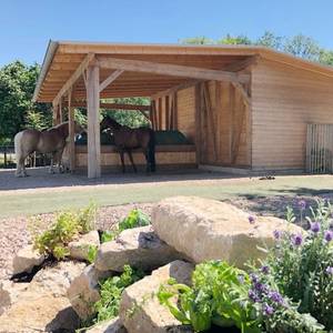

Paddocktrail-Offenstall-Gruppenhaltung-Reitanlage
Arnstadt
Triglishof
@Triglishof
Freizeitstall
Pferdeausbildung
Vermieten
Hunde willkommen
Krankenbox
Einhornhaltung möglich
Hufrehe geeignet
20 weitere...
P+
Deprecated: Creation of dynamic property Zend_View_Helper_Ads::$adLink is deprecated in /var/www/stall-frei/htdocs/staging.stall-frei.de/library/Psf/View/Helper/Ads.php on line 108

Futtersack HeuToy, Fressbremse in pink
Mechtersen
STALL-FREIde Marketing
@STALL-FREI-Marketing
Stundenlange Beschäftigung die
Koliken vorbeugt, geringe Staubinhalation mit
steuerbarer Futterentnahme

ganzj Weidestellplatz,Unterstand m matschfr. Zonen
Erfurt-Büßleben
janine lohbrandt
@JaLoh
Freizeitstall
Vermieten
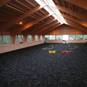
Reitplatz (z.B. Dressur, Springen, Reining)
Sattelkammer/Sattelschränke
Offenstall
2 weitere...
P
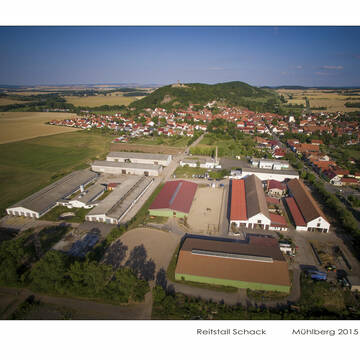
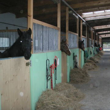
Reitstall Schack, Mühlberg
Drei Gleichen
Reistall-Schack
@Reistall-Schack
Freizeitstall
Pferdeausbildung
Vermieten
Führanlage
Krankenbox
Pferdezucht
Zuchtstutenhaltung möglich
20 weitere...
P
Leider kein Vorschaubild
Leider kein Vorschaubild
Pensionsplatz frei
Neudietendorf
Alice Zießler
@Waltraud.Roehrl
Freizeitstall
Vermieten
Hunde willkommen
Longierzirkel/Roundpen
Fohlenaufzucht möglich
Gnadenbrothof
14 weitere...
B

Pferdehof Kutscheralm
Berching-Pollanten
Martin Deflorin
@DeflorinMartin
Fahrstall, Kutschwagen
Freizeitstall
Hunde willkommen
Parkplatz für Pferdeanhänger
Hengsthaltung möglich
Hufrehe geeignet
Innenbox
14 weitere...
P


Stellplatz für Wallach ab sofort
Hassleben
Manja Höhne
@Manja1980
Freizeitstall
Hunde willkommen
Longierzirkel/Roundpen
Innenbox
Halbpension
8 weitere...
P+

Persönlichkeitsentwicklung mit Pferden
Bad Salzuflen
Katja Dors
@Pferdezeiten
Begleite andere auf ihrem Entwicklungsweg und entdecke die transformative Kraft der pferdegestützten Persönlichkeitsentwicklung !
neu
R

Buckarooranch Maik Wettstein
Gierstaedt
Buckarooranch Maik Wettstein
@The-Buckarooranch
Freizeitstall
Geländestrecke
Vermieten
Krankenbox
Longierzirkel/Roundpen
Allergikerstall
Gnadenbrothof
46 weitere...
P
Leider kein Vorschaubild
Leider kein Vorschaubild
Reitanlage Linda
Mechelroda
Nils Burmeister Reitanlage Lin
@Reit- und Fahrverein Weimar-Li...
FN-Mitglied
Freizeitstall
Vermieten
Longierzirkel/Roundpen
Paddock
Gnadenbrothof
Hengsthaltung möglich
28 weitere...
B

Pensionsstall, Reitunterricht, Beritt, Schulpferde
Ilmtal-Weinstraße
Rosshof Becker
@Rosshof-Becker1
FN-Mitglied
Freizeitstall
Vermieten
Krankenbox
Longierzirkel/Roundpen
Fohlenaufzucht möglich
Hengsthaltung möglich
23 weitere...
P
...lichtdurchfluteter Stall,grüne Wiesen...
Apolda
Reit-und-Fahrverein-Apolda-e-V
@Reit-und-Fahrverein-Apolda-e-V
Geländestrecke
Reitlehrer und -unterricht
Krankenbox
Longierzirkel/Roundpen
Bewegungsstall
Innenbox
Halbpension
Vollpension
15 weitere...
P
Deprecated: Creation of dynamic property Zend_View::$pageCount is deprecated in /var/www/stall-frei/htdocs/staging.stall-frei.de/library/vendor/shardj/zf1-future/library/Zend/View/Abstract.php on line 308
Deprecated: Creation of dynamic property Zend_View::$itemCountPerPage is deprecated in /var/www/stall-frei/htdocs/staging.stall-frei.de/library/vendor/shardj/zf1-future/library/Zend/View/Abstract.php on line 308
Deprecated: Creation of dynamic property Zend_View::$first is deprecated in /var/www/stall-frei/htdocs/staging.stall-frei.de/library/vendor/shardj/zf1-future/library/Zend/View/Abstract.php on line 308
Deprecated: Creation of dynamic property Zend_View::$current is deprecated in /var/www/stall-frei/htdocs/staging.stall-frei.de/library/vendor/shardj/zf1-future/library/Zend/View/Abstract.php on line 308
Deprecated: Creation of dynamic property Zend_View::$last is deprecated in /var/www/stall-frei/htdocs/staging.stall-frei.de/library/vendor/shardj/zf1-future/library/Zend/View/Abstract.php on line 308
Deprecated: Creation of dynamic property Zend_View::$next is deprecated in /var/www/stall-frei/htdocs/staging.stall-frei.de/library/vendor/shardj/zf1-future/library/Zend/View/Abstract.php on line 308
Deprecated: Creation of dynamic property Zend_View::$pagesInRange is deprecated in /var/www/stall-frei/htdocs/staging.stall-frei.de/library/vendor/shardj/zf1-future/library/Zend/View/Abstract.php on line 308
Deprecated: Creation of dynamic property Zend_View::$firstPageInRange is deprecated in /var/www/stall-frei/htdocs/staging.stall-frei.de/library/vendor/shardj/zf1-future/library/Zend/View/Abstract.php on line 308
Deprecated: Creation of dynamic property Zend_View::$lastPageInRange is deprecated in /var/www/stall-frei/htdocs/staging.stall-frei.de/library/vendor/shardj/zf1-future/library/Zend/View/Abstract.php on line 308
Deprecated: Creation of dynamic property Zend_View::$currentItemCount is deprecated in /var/www/stall-frei/htdocs/staging.stall-frei.de/library/vendor/shardj/zf1-future/library/Zend/View/Abstract.php on line 308
Deprecated: Creation of dynamic property Zend_View::$totalItemCount is deprecated in /var/www/stall-frei/htdocs/staging.stall-frei.de/library/vendor/shardj/zf1-future/library/Zend/View/Abstract.php on line 308
Deprecated: Creation of dynamic property Zend_View::$firstItemNumber is deprecated in /var/www/stall-frei/htdocs/staging.stall-frei.de/library/vendor/shardj/zf1-future/library/Zend/View/Abstract.php on line 308
Deprecated: Creation of dynamic property Zend_View::$lastItemNumber is deprecated in /var/www/stall-frei/htdocs/staging.stall-frei.de/library/vendor/shardj/zf1-future/library/Zend/View/Abstract.php on line 308
Deprecated: Creation of dynamic property Zend_View::$router is deprecated in /var/www/stall-frei/htdocs/staging.stall-frei.de/library/vendor/shardj/zf1-future/library/Zend/View/Abstract.php on line 308
Deprecated: Creation of dynamic property Zend_View::$urlParams is deprecated in /var/www/stall-frei/htdocs/staging.stall-frei.de/library/vendor/shardj/zf1-future/library/Zend/View/Abstract.php on line 308
Deprecated: Creation of dynamic property Zend_View::$PageRange is deprecated in /var/www/stall-frei/htdocs/staging.stall-frei.de/library/vendor/shardj/zf1-future/library/Zend/View/Abstract.php on line 308
19 Einträge auf 2 Seiten
Für deine Suchanfrage wurden 19 Einträge gefunden
19 Pferdeställe
Deprecated: Creation of dynamic property Zend_View::$summaryDone is deprecated in /var/www/stall-frei/htdocs/staging.stall-frei.de/library/vendor/shardj/zf1-future/library/Zend/View/Abstract.php on line 308

Paddocktrail-Offenstall-Gruppenhaltung-Reitanlage
Arnstadt
Triglishof
@Triglishof
Freizeitstall
Pferdeausbildung
Vermieten
Hunde willkommen
Krankenbox
Einhornhaltung möglich
Hufrehe geeignet
20 weitere...
P+
ganzj Weidestellplatz,Unterstand m matschfr. Zonen
Erfurt-Büßleben
janine lohbrandt
@JaLoh
Freizeitstall
Vermieten
Reitplatz (z.B. Dressur, Springen, Reining)
Sattelkammer/Sattelschränke
Offenstall
2 weitere...
P

Reitstall Schack, Mühlberg
Drei Gleichen
Reistall-Schack
@Reistall-Schack
Freizeitstall
Pferdeausbildung
Vermieten
Führanlage
Krankenbox
Pferdezucht
Zuchtstutenhaltung möglich
20 weitere...
P
Leider kein Vorschaubild
Leider kein Vorschaubild
Pensionsplatz frei
Neudietendorf
Alice Zießler
@Waltraud.Roehrl
Freizeitstall
Vermieten
Hunde willkommen
Longierzirkel/Roundpen
Fohlenaufzucht möglich
Gnadenbrothof
14 weitere...
B
Pferdehof Kutscheralm
Berching-Pollanten
Martin Deflorin
@DeflorinMartin
Fahrstall, Kutschwagen
Freizeitstall
Hunde willkommen
Parkplatz für Pferdeanhänger
Hengsthaltung möglich
Hufrehe geeignet
Innenbox
14 weitere...
P
Stellplatz für Wallach ab sofort
Hassleben
Manja Höhne
@Manja1980
Freizeitstall
Hunde willkommen
Longierzirkel/Roundpen
Innenbox
Halbpension
8 weitere...
P+
Buckarooranch Maik Wettstein
Gierstaedt
Buckarooranch Maik Wettstein
@The-Buckarooranch
Freizeitstall
Geländestrecke
Vermieten
Krankenbox
Longierzirkel/Roundpen
Allergikerstall
Gnadenbrothof
46 weitere...
P

Frisches Stroh zu verkaufen!
Mechtersen
STALL-FREIde Marketing
@STALL-FREI-Marketing
Kaufe frisches Stroh für dein Pferd!
Leider kein Vorschaubild
Leider kein Vorschaubild
Reitanlage Linda
Mechelroda
Nils Burmeister Reitanlage Lin
@Reit- und Fahrverein Weimar-Li...
FN-Mitglied
Freizeitstall
Vermieten
Longierzirkel/Roundpen
Paddock
Gnadenbrothof
Hengsthaltung möglich
28 weitere...
B
Pensionsstall, Reitunterricht, Beritt, Schulpferde
Ilmtal-Weinstraße
Rosshof Becker
@Rosshof-Becker1
FN-Mitglied
Freizeitstall
Vermieten
Krankenbox
Longierzirkel/Roundpen
Fohlenaufzucht möglich
Hengsthaltung möglich
23 weitere...
P
...lichtdurchfluteter Stall,grüne Wiesen...
Apolda
Reit-und-Fahrverein-Apolda-e-V
@Reit-und-Fahrverein-Apolda-e-V
Geländestrecke
Reitlehrer und -unterricht
Krankenbox
Longierzirkel/Roundpen
Bewegungsstall
Innenbox
Halbpension
Vollpension
15 weitere...
P
Deprecated: strlen(): Passing null to parameter #1 ($string) of type string is deprecated in /var/www/stall-frei/htdocs/staging.stall-frei.de/application/modules/object/views/scripts/list/_list_location_hints.phtml on line 10
Deprecated: Creation of dynamic property Zend_View::$pageCount is deprecated in /var/www/stall-frei/htdocs/staging.stall-frei.de/library/vendor/shardj/zf1-future/library/Zend/View/Abstract.php on line 308
Deprecated: Creation of dynamic property Zend_View::$itemCountPerPage is deprecated in /var/www/stall-frei/htdocs/staging.stall-frei.de/library/vendor/shardj/zf1-future/library/Zend/View/Abstract.php on line 308
Deprecated: Creation of dynamic property Zend_View::$first is deprecated in /var/www/stall-frei/htdocs/staging.stall-frei.de/library/vendor/shardj/zf1-future/library/Zend/View/Abstract.php on line 308
Deprecated: Creation of dynamic property Zend_View::$current is deprecated in /var/www/stall-frei/htdocs/staging.stall-frei.de/library/vendor/shardj/zf1-future/library/Zend/View/Abstract.php on line 308
Deprecated: Creation of dynamic property Zend_View::$last is deprecated in /var/www/stall-frei/htdocs/staging.stall-frei.de/library/vendor/shardj/zf1-future/library/Zend/View/Abstract.php on line 308
Deprecated: Creation of dynamic property Zend_View::$next is deprecated in /var/www/stall-frei/htdocs/staging.stall-frei.de/library/vendor/shardj/zf1-future/library/Zend/View/Abstract.php on line 308
Deprecated: Creation of dynamic property Zend_View::$pagesInRange is deprecated in /var/www/stall-frei/htdocs/staging.stall-frei.de/library/vendor/shardj/zf1-future/library/Zend/View/Abstract.php on line 308
Deprecated: Creation of dynamic property Zend_View::$firstPageInRange is deprecated in /var/www/stall-frei/htdocs/staging.stall-frei.de/library/vendor/shardj/zf1-future/library/Zend/View/Abstract.php on line 308
Deprecated: Creation of dynamic property Zend_View::$lastPageInRange is deprecated in /var/www/stall-frei/htdocs/staging.stall-frei.de/library/vendor/shardj/zf1-future/library/Zend/View/Abstract.php on line 308
Deprecated: Creation of dynamic property Zend_View::$currentItemCount is deprecated in /var/www/stall-frei/htdocs/staging.stall-frei.de/library/vendor/shardj/zf1-future/library/Zend/View/Abstract.php on line 308
Deprecated: Creation of dynamic property Zend_View::$totalItemCount is deprecated in /var/www/stall-frei/htdocs/staging.stall-frei.de/library/vendor/shardj/zf1-future/library/Zend/View/Abstract.php on line 308
Deprecated: Creation of dynamic property Zend_View::$firstItemNumber is deprecated in /var/www/stall-frei/htdocs/staging.stall-frei.de/library/vendor/shardj/zf1-future/library/Zend/View/Abstract.php on line 308
Deprecated: Creation of dynamic property Zend_View::$lastItemNumber is deprecated in /var/www/stall-frei/htdocs/staging.stall-frei.de/library/vendor/shardj/zf1-future/library/Zend/View/Abstract.php on line 308
Deprecated: Creation of dynamic property Zend_View::$router is deprecated in /var/www/stall-frei/htdocs/staging.stall-frei.de/library/vendor/shardj/zf1-future/library/Zend/View/Abstract.php on line 308
Deprecated: Creation of dynamic property Zend_View::$urlParams is deprecated in /var/www/stall-frei/htdocs/staging.stall-frei.de/library/vendor/shardj/zf1-future/library/Zend/View/Abstract.php on line 308
Deprecated: Creation of dynamic property Zend_View::$PageRange is deprecated in /var/www/stall-frei/htdocs/staging.stall-frei.de/library/vendor/shardj/zf1-future/library/Zend/View/Abstract.php on line 308
19 Einträge auf 2 Seiten
Deprecated: Creation of dynamic property Zend_View::$showFilterBar is deprecated in /var/www/stall-frei/htdocs/staging.stall-frei.de/library/vendor/shardj/zf1-future/library/Zend/View/Abstract.php on line 308
Deprecated: Creation of dynamic property Zend_View::$pageTitle is deprecated in /var/www/stall-frei/htdocs/staging.stall-frei.de/library/vendor/shardj/zf1-future/library/Zend/View/Abstract.php on line 308
Deprecated: Creation of dynamic property Zend_View::$isSearch is deprecated in /var/www/stall-frei/htdocs/staging.stall-frei.de/library/vendor/shardj/zf1-future/library/Zend/View/Abstract.php on line 308
Deprecated: Creation of dynamic property Psf_Form_Element_Text::$class is deprecated in /var/www/stall-frei/htdocs/staging.stall-frei.de/library/vendor/shardj/zf1-future/library/Zend/Form/Element.php on line 874
Deprecated: Creation of dynamic property Psf_Form_Element_Text::$size is deprecated in /var/www/stall-frei/htdocs/staging.stall-frei.de/library/vendor/shardj/zf1-future/library/Zend/Form/Element.php on line 874
Deprecated: Creation of dynamic property Psf_Form_Element_Text::$placeholder is deprecated in /var/www/stall-frei/htdocs/staging.stall-frei.de/library/vendor/shardj/zf1-future/library/Zend/Form/Element.php on line 874
Deprecated: Creation of dynamic property Psf_Form_Element_Hidden::$class is deprecated in /var/www/stall-frei/htdocs/staging.stall-frei.de/library/vendor/shardj/zf1-future/library/Zend/Form/Element.php on line 874
Deprecated: Creation of dynamic property Psf_Form_Element_Hidden::$class is deprecated in /var/www/stall-frei/htdocs/staging.stall-frei.de/library/vendor/shardj/zf1-future/library/Zend/Form/Element.php on line 874
Deprecated: Creation of dynamic property Psf_Form_Element_Hidden::$class is deprecated in /var/www/stall-frei/htdocs/staging.stall-frei.de/library/vendor/shardj/zf1-future/library/Zend/Form/Element.php on line 874
Deprecated: Creation of dynamic property Psf_Form_Element_Hidden::$class is deprecated in /var/www/stall-frei/htdocs/staging.stall-frei.de/library/vendor/shardj/zf1-future/library/Zend/Form/Element.php on line 874
Deprecated: Creation of dynamic property Psf_Form_Element_Select::$class is deprecated in /var/www/stall-frei/htdocs/staging.stall-frei.de/library/vendor/shardj/zf1-future/library/Zend/Form/Element.php on line 874
Deprecated: Creation of dynamic property Psf_Form_Element_Select::$class is deprecated in /var/www/stall-frei/htdocs/staging.stall-frei.de/library/vendor/shardj/zf1-future/library/Zend/Form/Element.php on line 874
Deprecated: Creation of dynamic property Psf_Form_Element_Select::$class is deprecated in /var/www/stall-frei/htdocs/staging.stall-frei.de/library/vendor/shardj/zf1-future/library/Zend/Form/Element.php on line 874
Deprecated: Creation of dynamic property Psf_Form_Element_Select::$class is deprecated in /var/www/stall-frei/htdocs/staging.stall-frei.de/library/vendor/shardj/zf1-future/library/Zend/Form/Element.php on line 874
Deprecated: Creation of dynamic property Psf_Form_Element_Text::$class is deprecated in /var/www/stall-frei/htdocs/staging.stall-frei.de/library/vendor/shardj/zf1-future/library/Zend/Form/Element.php on line 874
Deprecated: Creation of dynamic property Psf_Form_Element_Checkbox::$label is deprecated in /var/www/stall-frei/htdocs/staging.stall-frei.de/library/vendor/shardj/zf1-future/library/Zend/Form/Element.php on line 874
Deprecated: Creation of dynamic property Zend_View::$searchLocationString is deprecated in /var/www/stall-frei/htdocs/staging.stall-frei.de/library/vendor/shardj/zf1-future/library/Zend/View/Abstract.php on line 308
Deprecated: Creation of dynamic property Zend_View::$oSearchForm is deprecated in /var/www/stall-frei/htdocs/staging.stall-frei.de/library/vendor/shardj/zf1-future/library/Zend/View/Abstract.php on line 308
Deprecated: Creation of dynamic property Zend_View::$locationHintStyle is deprecated in /var/www/stall-frei/htdocs/staging.stall-frei.de/library/vendor/shardj/zf1-future/library/Zend/View/Abstract.php on line 308
Psf_GeoCoder_Abstract::getLocationList: Wüllersleben, Ilm-Kreis
Psf_GeoCoder_Abstract::getLocationList: Wüllersleben, Ilm-Kreis
Array
(
    [/stall/thueringen/wuellersleben/154449] =>
)
Psf_GeoCoder_Abstract::getCachedOrLive: Wüllersleben, Ilm-Kreis
Psf_GeoCoder_OpenCageData::makeApiRequest: response:
Array
(
[documentation] => https://opencagedata.com/api
[licenses] => Array
(
[0] => Array
(
[name] => see attribution guide
[url] => https://opencagedata.com/credits
)
)
[results] => Array
(
[0] => Array
(
[bounds] => Array
(
[northeast] => Array
(
[lat] => 50.8343296
[lng] => 11.0884671
)
[southwest] => Array
(
[lat] => 50.7943296
[lng] => 11.0484671
)
)
[components] => Array
(
[ISO_3166-1_alpha-2] => DE
[ISO_3166-1_alpha-3] => DEU
[ISO_3166-2] => Array
(
[0] => DE-TH
)
[_category] => place
[_normalized_city] => Bösleben-Wüllersleben
[_type] => village
[city] => Bösleben-Wüllersleben
[continent] => Europe
[country] => Deutschland
[country_code] => de
[county] => Ilm-Kreis
[municipality] => Riechheimer Berg
[political_union] => European Union
[state] => Thüringen
[state_code] => TH
[village] => Wüllersleben
)
[confidence] => 7
[formatted] => Wüllersleben, Thüringen, Deutschland
[geometry] => Array
(
[lat] => 50.8143296
[lng] => 11.0684671
)
)
[1] => Array
(
[bounds] => Array
(
[northeast] => Array
(
[lat] => 50.8398155
[lng] => 11.0974314
)
[southwest] => Array
(
[lat] => 50.7917677
[lng] => 11.0364409
)
)
[components] => Array
(
[ISO_3166-1_alpha-2] => DE
[ISO_3166-1_alpha-3] => DEU
[ISO_3166-2] => Array
(
[0] => DE-TH
)
[_category] => place
[_normalized_city] => Bösleben-Wüllersleben
[_type] => village
[continent] => Europe
[country] => Deutschland
[country_code] => de
[county] => Ilm-Kreis
[municipality] => Riechheimer Berg
[political_union] => European Union
[state] => Thüringen
[state_code] => TH
[village] => Bösleben-Wüllersleben
)
[confidence] => 7
[formatted] => Bösleben-Wüllersleben, Thüringen, Deutschland
[geometry] => Array
(
[lat] => 50.8261541
[lng] => 11.0591532
)
)
[2] => Array
(
[components] => Array
(
[ISO_3166-1_alpha-2] => FR
[ISO_3166-1_alpha-3] => FRA
[ISO_3166-2] => Array
(
[0] => FR-BRE
[1] => FR-29
)
[_category] => road
[_normalized_city] => Locquirec
[_type] => road
[city] => Locquirec
[continent] => Europe
[country] => France
[country_code] => fr
[county] => Finistère
[local_authority] => Morlaix Communauté
[political_union] => European Union
[postcode] => 29241
[road] => Allée Tachen Kreis
[state] => Bretagne
[state_code] => BRE
)
[confidence] => 3
[formatted] => Allée Tachen Kreis, 29241 Locquirec, France
[geometry] => Array
(
[lat] => 48.686383
[lng] => -3.667181
)
)
[3] => Array
(
[components] => Array
(
[ISO_3166-1_alpha-2] => FR
[ISO_3166-1_alpha-3] => FRA
[ISO_3166-2] => Array
(
[0] => FR-BRE
[1] => FR-29
)
[_category] => road
[_normalized_city] => Taulé
[_type] => road
[city] => Taulé
[continent] => Europe
[country] => France
[country_code] => fr
[county] => Finistère
[local_authority] => Morlaix Communauté
[political_union] => European Union
[postcode] => 29670
[road] => Ty Creis Kerambellec
[state] => Bretagne
[state_code] => BRE
)
[confidence] => 2
[formatted] => Ty Creis Kerambellec, 29670 Taulé, France
[geometry] => Array
(
[lat] => 48.618999
[lng] => -3.891101
)
)
[4] => Array
(
[components] => Array
(
[ISO_3166-1_alpha-2] => FR
[ISO_3166-1_alpha-3] => FRA
[ISO_3166-2] => Array
(
[0] => FR-BRE
[1] => FR-29
)
[_category] => road
[_normalized_city] => Plomodiern
[_type] => road
[city] => Plomodiern
[continent] => Europe
[country] => France
[country_code] => fr
[county] => Finistère
[local_authority] => Communauté de communes de Pleyben-Châteaulin-Porzay
[political_union] => European Union
[postcode] => 29550
[road] => Saint Gilles Kreis
[state] => Bretagne
[state_code] => BRE
)
[confidence] => 2
[formatted] => Saint Gilles Kreis, 29550 Plomodiern, France
[geometry] => Array
(
[lat] => 48.173233
[lng] => -4.215298
)
)
[5] => Array
(
[components] => Array
(
[ISO_3166-1_alpha-2] => FR
[ISO_3166-1_alpha-3] => FRA
[ISO_3166-2] => Array
(
[0] => FR-BRE
[1] => FR-29
)
[_category] => place
[_normalized_city] => Plogonnec
[_type] => place
[city] => Plogonnec
[continent] => Europe
[country] => France
[country_code] => fr
[county] => Finistère
[local_authority] => Quimper Bretagne Occidentale
[place] => Kreis-Ker
[political_union] => European Union
[postcode] => 29180
[state] => Bretagne
[state_code] => BRE
)
[confidence] => 2
[formatted] => Kreis-Ker, 29180 Plogonnec, France
[geometry] => Array
(
[lat] => 48.087723
[lng] => -4.106369
)
)
[6] => Array
(
[components] => Array
(
[ISO_3166-1_alpha-2] => FR
[ISO_3166-1_alpha-3] => FRA
[ISO_3166-2] => Array
(
[0] => FR-BRE
[1] => FR-29
)
[_category] => road
[_normalized_city] => Loctudy
[_type] => road
[city] => Loctudy
[continent] => Europe
[country] => France
[country_code] => fr
[county] => Finistère
[local_authority] => Communauté de communes du Pays Bigouden Sud
[political_union] => European Union
[postcode] => 29750
[road] => Ezer Kreis
[state] => Bretagne
[state_code] => BRE
)
[confidence] => 2
[formatted] => Ezer Kreis, 29750 Loctudy, France
[geometry] => Array
(
[lat] => 47.815445
[lng] => -4.17501
)
)
[7] => Array
(
[components] => Array
(
[ISO_3166-1_alpha-2] => FR
[ISO_3166-1_alpha-3] => FRA
[ISO_3166-2] => Array
(
[0] => FR-BRE
[1] => FR-29
)
[_category] => road
[_normalized_city] => Pleyben
[_type] => road
[city] => Pleyben
[continent] => Europe
[country] => France
[country_code] => fr
[county] => Finistère
[local_authority] => Communauté de communes de Pleyben-Châteaulin-Porzay
[political_union] => European Union
[postcode] => 29190
[road] => Marros Kreis
[state] => Bretagne
[state_code] => BRE
)
[confidence] => 2
[formatted] => Marros Kreis, 29190 Pleyben, France
[geometry] => Array
(
[lat] => 48.199917
[lng] => -3.974274
)
)
[8] => Array
(
[components] => Array
(
[ISO_3166-1_alpha-2] => FR
[ISO_3166-1_alpha-3] => FRA
[ISO_3166-2] => Array
(
[0] => FR-BRE
[1] => FR-29
)
[_category] => road
[_normalized_city] => Crozon
[_type] => road
[city] => Crozon
[continent] => Europe
[country] => France
[country_code] => fr
[county] => Finistère
[local_authority] => Communauté de communes Presqu’île de Crozon-Aulne Maritime
[political_union] => European Union
[postcode] => 29160
[road] => Kerveneure Kreis
[state] => Bretagne
[state_code] => BRE
)
[confidence] => 2
[formatted] => Kerveneure Kreis, 29160 Crozon, France
[geometry] => Array
(
[lat] => 48.267342
[lng] => -4.479945
)
)
[9] => Array
(
[components] => Array
(
[ISO_3166-1_alpha-2] => FR
[ISO_3166-1_alpha-3] => FRA
[ISO_3166-2] => Array
(
[0] => FR-BRE
[1] => FR-29
)
[_category] => road
[_normalized_city] => Crozon
[_type] => road
[city] => Crozon
[continent] => Europe
[country] => France
[country_code] => fr
[county] => Finistère
[local_authority] => Communauté de communes Presqu’île de Crozon-Aulne Maritime
[political_union] => European Union
[postcode] => 29160
[road] => allée Kreis Kador
[state] => Bretagne
[state_code] => BRE
)
[confidence] => 2
[formatted] => allée Kreis Kador, 29160 Crozon, France
[geometry] => Array
(
[lat] => 48.219173
[lng] => -4.506225
)
)
)
[status] => Array
(
[code] => 200
[message] => OK
)
[stay_informed] => Array
(
[blog] => https://blog.opencagedata.com
[mastodon] => https://en.osm.town/@opencage
)
[thanks] => For using an OpenCage API
[timestamp] => Array
(
[created_http] => Sat, 07 Feb 2026 05:21:10 GMT
[created_unix] => 1770441670
)
[total_results] => 10
)
{"documentation":"https:\/\/opencagedata.com\/api","licenses":[{"name":"see attribution guide","url":"https:\/\/opencagedata.com\/credits"}],"results":[{"bounds":{"northeast":{"lat":50.8343296,"lng":11.0884671},"southwest":{"lat":50.7943296,"lng":11.0484671}},"components":{"ISO_3166-1_alpha-2":"DE","ISO_3166-1_alpha-3":"DEU","ISO_3166-2":["DE-TH"],"_category":"place","_normalized_city":"B\u00f6sleben-W\u00fcllersleben","_type":"village","city":"B\u00f6sleben-W\u00fcllersleben","continent":"Europe","country":"Deutschland","country_code":"de","county":"Ilm-Kreis","municipality":"Riechheimer Berg","political_union":"European Union","state":"Th\u00fcringen","state_code":"TH","village":"W\u00fcllersleben"},"confidence":7,"formatted":"W\u00fcllersleben, Th\u00fcringen, Deutschland","geometry":{"lat":50.8143296,"lng":11.0684671}},{"bounds":{"northeast":{"lat":50.8398155,"lng":11.0974314},"southwest":{"lat":50.7917677,"lng":11.0364409}},"components":{"ISO_3166-1_alpha-2":"DE","ISO_3166-1_alpha-3":"DEU","ISO_3166-2":["DE-TH"],"_category":"place","_normalized_city":"B\u00f6sleben-W\u00fcllersleben","_type":"village","continent":"Europe","country":"Deutschland","country_code":"de","county":"Ilm-Kreis","municipality":"Riechheimer Berg","political_union":"European Union","state":"Th\u00fcringen","state_code":"TH","village":"B\u00f6sleben-W\u00fcllersleben"},"confidence":7,"formatted":"B\u00f6sleben-W\u00fcllersleben, Th\u00fcringen, Deutschland","geometry":{"lat":50.8261541,"lng":11.0591532}},{"components":{"ISO_3166-1_alpha-2":"FR","ISO_3166-1_alpha-3":"FRA","ISO_3166-2":["FR-BRE","FR-29"],"_category":"road","_normalized_city":"Locquirec","_type":"road","city":"Locquirec","continent":"Europe","country":"France","country_code":"fr","county":"Finist\u00e8re","local_authority":"Morlaix Communaut\u00e9","political_union":"European Union","postcode":"29241","road":"All\u00e9e Tachen Kreis","state":"Bretagne","state_code":"BRE"},"confidence":3,"formatted":"All\u00e9e Tachen Kreis, 29241 Locquirec, France","geometry":{"lat":48.686383,"lng":-3.667181}},{"components":{"ISO_3166-1_alpha-2":"FR","ISO_3166-1_alpha-3":"FRA","ISO_3166-2":["FR-BRE","FR-29"],"_category":"road","_normalized_city":"Taul\u00e9","_type":"road","city":"Taul\u00e9","continent":"Europe","country":"France","country_code":"fr","county":"Finist\u00e8re","local_authority":"Morlaix Communaut\u00e9","political_union":"European Union","postcode":"29670","road":"Ty Creis Kerambellec","state":"Bretagne","state_code":"BRE"},"confidence":2,"formatted":"Ty Creis Kerambellec, 29670 Taul\u00e9, France","geometry":{"lat":48.618999,"lng":-3.891101}},{"components":{"ISO_3166-1_alpha-2":"FR","ISO_3166-1_alpha-3":"FRA","ISO_3166-2":["FR-BRE","FR-29"],"_category":"road","_normalized_city":"Plomodiern","_type":"road","city":"Plomodiern","continent":"Europe","country":"France","country_code":"fr","county":"Finist\u00e8re","local_authority":"Communaut\u00e9 de communes de Pleyben-Ch\u00e2teaulin-Porzay","political_union":"European Union","postcode":"29550","road":"Saint Gilles Kreis","state":"Bretagne","state_code":"BRE"},"confidence":2,"formatted":"Saint Gilles Kreis, 29550 Plomodiern, France","geometry":{"lat":48.173233,"lng":-4.215298}},{"components":{"ISO_3166-1_alpha-2":"FR","ISO_3166-1_alpha-3":"FRA","ISO_3166-2":["FR-BRE","FR-29"],"_category":"place","_normalized_city":"Plogonnec","_type":"place","city":"Plogonnec","continent":"Europe","country":"France","country_code":"fr","county":"Finist\u00e8re","local_authority":"Quimper Bretagne Occidentale","place":"Kreis-Ker","political_union":"European Union","postcode":"29180","state":"Bretagne","state_code":"BRE"},"confidence":2,"formatted":"Kreis-Ker, 29180 Plogonnec, France","geometry":{"lat":48.087723,"lng":-4.106369}},{"components":{"ISO_3166-1_alpha-2":"FR","ISO_3166-1_alpha-3":"FRA","ISO_3166-2":["FR-BRE","FR-29"],"_category":"road","_normalized_city":"Loctudy","_type":"road","city":"Loctudy","continent":"Europe","country":"France","country_code":"fr","county":"Finist\u00e8re","local_authority":"Communaut\u00e9 de communes du Pays Bigouden Sud","political_union":"European Union","postcode":"29750","road":"Ezer Kreis","state":"Bretagne","state_code":"BRE"},"confidence":2,"formatted":"Ezer Kreis, 29750 Loctudy, France","geometry":{"lat":47.815445,"lng":-4.17501}},{"components":{"ISO_3166-1_alpha-2":"FR","ISO_3166-1_alpha-3":"FRA","ISO_3166-2":["FR-BRE","FR-29"],"_category":"road","_normalized_city":"Pleyben","_type":"road","city":"Pleyben","continent":"Europe","country":"France","country_code":"fr","county":"Finist\u00e8re","local_authority":"Communaut\u00e9 de communes de Pleyben-Ch\u00e2teaulin-Porzay","political_union":"European Union","postcode":"29190","road":"Marros Kreis","state":"Bretagne","state_code":"BRE"},"confidence":2,"formatted":"Marros Kreis, 29190 Pleyben, France","geometry":{"lat":48.199917,"lng":-3.974274}},{"components":{"ISO_3166-1_alpha-2":"FR","ISO_3166-1_alpha-3":"FRA","ISO_3166-2":["FR-BRE","FR-29"],"_category":"road","_normalized_city":"Crozon","_type":"road","city":"Crozon","continent":"Europe","country":"France","country_code":"fr","county":"Finist\u00e8re","local_authority":"Communaut\u00e9 de communes Presqu\u2019\u00eele de Crozon-Aulne Maritime","political_union":"European Union","postcode":"29160","road":"Kerveneure Kreis","state":"Bretagne","state_code":"BRE"},"confidence":2,"formatted":"Kerveneure Kreis, 29160 Crozon, France","geometry":{"lat":48.267342,"lng":-4.479945}},{"components":{"ISO_3166-1_alpha-2":"FR","ISO_3166-1_alpha-3":"FRA","ISO_3166-2":["FR-BRE","FR-29"],"_category":"road","_normalized_city":"Crozon","_type":"road","city":"Crozon","continent":"Europe","country":"France","country_code":"fr","county":"Finist\u00e8re","local_authority":"Communaut\u00e9 de communes Presqu\u2019\u00eele de Crozon-Aulne Maritime","political_union":"European Union","postcode":"29160","road":"all\u00e9e Kreis Kador","state":"Bretagne","state_code":"BRE"},"confidence":2,"formatted":"all\u00e9e Kreis Kador, 29160 Crozon, France","geometry":{"lat":48.219173,"lng":-4.506225}}],"status":{"code":200,"message":"OK"},"stay_informed":{"blog":"https:\/\/blog.opencagedata.com","mastodon":"https:\/\/en.osm.town\/@opencage"},"thanks":"For using an OpenCage API","timestamp":{"created_http":"Sat, 07 Feb 2026 05:21:10 GMT","created_unix":1770441670},"total_results":10}Array
(
[0] => stdClass Object
(
[bounds] => stdClass Object
(
[northeast] => stdClass Object
(
[lat] => 50.8343296
[lng] => 11.0884671
)
[southwest] => stdClass Object
(
[lat] => 50.7943296
[lng] => 11.0484671
)
)
[components] => stdClass Object
(
[ISO_3166-1_alpha-2] => DE
[ISO_3166-1_alpha-3] => DEU
[ISO_3166-2] => Array
(
[0] => DE-TH
)
[_category] => place
[_normalized_city] => Bösleben-Wüllersleben
[_type] => village
[city] => Bösleben-Wüllersleben
[continent] => Europe
[country] => Deutschland
[country_code] => de
[county] => Ilm-Kreis
[municipality] => Riechheimer Berg
[political_union] => European Union
[state] => Thüringen
[state_code] => TH
[village] => Wüllersleben
)
[confidence] => 7
[formatted] => Wüllersleben, Thüringen, Deutschland
[geometry] => stdClass Object
(
[lat] => 50.8143296
[lng] => 11.0684671
)
)
[1] => stdClass Object
(
[bounds] => stdClass Object
(
[northeast] => stdClass Object
(
[lat] => 50.8398155
[lng] => 11.0974314
)
[southwest] => stdClass Object
(
[lat] => 50.7917677
[lng] => 11.0364409
)
)
[components] => stdClass Object
(
[ISO_3166-1_alpha-2] => DE
[ISO_3166-1_alpha-3] => DEU
[ISO_3166-2] => Array
(
[0] => DE-TH
)
[_category] => place
[_normalized_city] => Bösleben-Wüllersleben
[_type] => village
[continent] => Europe
[country] => Deutschland
[country_code] => de
[county] => Ilm-Kreis
[municipality] => Riechheimer Berg
[political_union] => European Union
[state] => Thüringen
[state_code] => TH
[village] => Bösleben-Wüllersleben
)
[confidence] => 7
[formatted] => Bösleben-Wüllersleben, Thüringen, Deutschland
[geometry] => stdClass Object
(
[lat] => 50.8261541
[lng] => 11.0591532
)
)
[2] => stdClass Object
(
[components] => stdClass Object
(
[ISO_3166-1_alpha-2] => FR
[ISO_3166-1_alpha-3] => FRA
[ISO_3166-2] => Array
(
[0] => FR-BRE
[1] => FR-29
)
[_category] => road
[_normalized_city] => Locquirec
[_type] => road
[city] => Locquirec
[continent] => Europe
[country] => France
[country_code] => fr
[county] => Finistère
[local_authority] => Morlaix Communauté
[political_union] => European Union
[postcode] => 29241
[road] => Allée Tachen Kreis
[state] => Bretagne
[state_code] => BRE
)
[confidence] => 3
[formatted] => Allée Tachen Kreis, 29241 Locquirec, France
[geometry] => stdClass Object
(
[lat] => 48.686383
[lng] => -3.667181
)
)
[3] => stdClass Object
(
[components] => stdClass Object
(
[ISO_3166-1_alpha-2] => FR
[ISO_3166-1_alpha-3] => FRA
[ISO_3166-2] => Array
(
[0] => FR-BRE
[1] => FR-29
)
[_category] => road
[_normalized_city] => Taulé
[_type] => road
[city] => Taulé
[continent] => Europe
[country] => France
[country_code] => fr
[county] => Finistère
[local_authority] => Morlaix Communauté
[political_union] => European Union
[postcode] => 29670
[road] => Ty Creis Kerambellec
[state] => Bretagne
[state_code] => BRE
)
[confidence] => 2
[formatted] => Ty Creis Kerambellec, 29670 Taulé, France
[geometry] => stdClass Object
(
[lat] => 48.618999
[lng] => -3.891101
)
)
[4] => stdClass Object
(
[components] => stdClass Object
(
[ISO_3166-1_alpha-2] => FR
[ISO_3166-1_alpha-3] => FRA
[ISO_3166-2] => Array
(
[0] => FR-BRE
[1] => FR-29
)
[_category] => road
[_normalized_city] => Plomodiern
[_type] => road
[city] => Plomodiern
[continent] => Europe
[country] => France
[country_code] => fr
[county] => Finistère
[local_authority] => Communauté de communes de Pleyben-Châteaulin-Porzay
[political_union] => European Union
[postcode] => 29550
[road] => Saint Gilles Kreis
[state] => Bretagne
[state_code] => BRE
)
[confidence] => 2
[formatted] => Saint Gilles Kreis, 29550 Plomodiern, France
[geometry] => stdClass Object
(
[lat] => 48.173233
[lng] => -4.215298
)
)
[5] => stdClass Object
(
[components] => stdClass Object
(
[ISO_3166-1_alpha-2] => FR
[ISO_3166-1_alpha-3] => FRA
[ISO_3166-2] => Array
(
[0] => FR-BRE
[1] => FR-29
)
[_category] => place
[_normalized_city] => Plogonnec
[_type] => place
[city] => Plogonnec
[continent] => Europe
[country] => France
[country_code] => fr
[county] => Finistère
[local_authority] => Quimper Bretagne Occidentale
[place] => Kreis-Ker
[political_union] => European Union
[postcode] => 29180
[state] => Bretagne
[state_code] => BRE
)
[confidence] => 2
[formatted] => Kreis-Ker, 29180 Plogonnec, France
[geometry] => stdClass Object
(
[lat] => 48.087723
[lng] => -4.106369
)
)
[6] => stdClass Object
(
[components] => stdClass Object
(
[ISO_3166-1_alpha-2] => FR
[ISO_3166-1_alpha-3] => FRA
[ISO_3166-2] => Array
(
[0] => FR-BRE
[1] => FR-29
)
[_category] => road
[_normalized_city] => Loctudy
[_type] => road
[city] => Loctudy
[continent] => Europe
[country] => France
[country_code] => fr
[county] => Finistère
[local_authority] => Communauté de communes du Pays Bigouden Sud
[political_union] => European Union
[postcode] => 29750
[road] => Ezer Kreis
[state] => Bretagne
[state_code] => BRE
)
[confidence] => 2
[formatted] => Ezer Kreis, 29750 Loctudy, France
[geometry] => stdClass Object
(
[lat] => 47.815445
[lng] => -4.17501
)
)
[7] => stdClass Object
(
[components] => stdClass Object
(
[ISO_3166-1_alpha-2] => FR
[ISO_3166-1_alpha-3] => FRA
[ISO_3166-2] => Array
(
[0] => FR-BRE
[1] => FR-29
)
[_category] => road
[_normalized_city] => Pleyben
[_type] => road
[city] => Pleyben
[continent] => Europe
[country] => France
[country_code] => fr
[county] => Finistère
[local_authority] => Communauté de communes de Pleyben-Châteaulin-Porzay
[political_union] => European Union
[postcode] => 29190
[road] => Marros Kreis
[state] => Bretagne
[state_code] => BRE
)
[confidence] => 2
[formatted] => Marros Kreis, 29190 Pleyben, France
[geometry] => stdClass Object
(
[lat] => 48.199917
[lng] => -3.974274
)
)
[8] => stdClass Object
(
[components] => stdClass Object
(
[ISO_3166-1_alpha-2] => FR
[ISO_3166-1_alpha-3] => FRA
[ISO_3166-2] => Array
(
[0] => FR-BRE
[1] => FR-29
)
[_category] => road
[_normalized_city] => Crozon
[_type] => road
[city] => Crozon
[continent] => Europe
[country] => France
[country_code] => fr
[county] => Finistère
[local_authority] => Communauté de communes Presqu’île de Crozon-Aulne Maritime
[political_union] => European Union
[postcode] => 29160
[road] => Kerveneure Kreis
[state] => Bretagne
[state_code] => BRE
)
[confidence] => 2
[formatted] => Kerveneure Kreis, 29160 Crozon, France
[geometry] => stdClass Object
(
[lat] => 48.267342
[lng] => -4.479945
)
)
[9] => stdClass Object
(
[components] => stdClass Object
(
[ISO_3166-1_alpha-2] => FR
[ISO_3166-1_alpha-3] => FRA
[ISO_3166-2] => Array
(
[0] => FR-BRE
[1] => FR-29
)
[_category] => road
[_normalized_city] => Crozon
[_type] => road
[city] => Crozon
[continent] => Europe
[country] => France
[country_code] => fr
[county] => Finistère
[local_authority] => Communauté de communes Presqu’île de Crozon-Aulne Maritime
[political_union] => European Union
[postcode] => 29160
[road] => allée Kreis Kador
[state] => Bretagne
[state_code] => BRE
)
[confidence] => 2
[formatted] => allée Kreis Kador, 29160 Crozon, France
[geometry] => stdClass Object
(
[lat] => 48.219173
[lng] => -4.506225
)
)
)
Psf_GeoCoder_OpenCageData::getKeyMap: 0
stdClass Object
(
    [bounds] => stdClass Object
        (
            [northeast] => stdClass Object
                (
                    [lat] => 50.8343296
                    [lng] => 11.0884671
                )

            [southwest] => stdClass Object
                (
                    [lat] => 50.7943296
                    [lng] => 11.0484671
                )

        )

    [components] => stdClass Object
        (
            [ISO_3166-1_alpha-2] => DE
            [ISO_3166-1_alpha-3] => DEU
            [ISO_3166-2] => Array
                (
                    [0] => DE-TH
                )

            [_category] => place
            [_normalized_city] => Bösleben-Wüllersleben
            [_type] => village
            [city] => Bösleben-Wüllersleben
            [continent] => Europe
            [country] => Deutschland
            [country_code] => de
            [county] => Ilm-Kreis
            [municipality] => Riechheimer Berg
            [political_union] => European Union
            [state] => Thüringen
            [state_code] => TH
            [village] => Wüllersleben
        )

    [confidence] => 7
    [formatted] => Wüllersleben, Thüringen, Deutschland
    [geometry] => stdClass Object
        (
            [lat] => 50.8143296
            [lng] => 11.0684671
        )

)
Psf_GeoCoder_OpenCageData::getCounty: Ilm-Kreis
Psf_GeoCoder_OpenCageData::addMissingData REFETCH!
Array
(
    [address] => Wüllersleben, Thüringen, Deutschland
    [type] => village
    [street] =>
    [city] => Wüllersleben
    [county] => Ilm-Kreis
    [state] => Thüringen
    [zip] =>
    [country] => Deutschland
    [suburb] =>
    [countrycode] => de
    [latitude] => 50.8143296
    [longitude] => 11.0684671
    [accuracy] => 1
    [confidence] => 7
    [bounds] => stdClass Object
        (
            [northeast] => stdClass Object
                (
                    [lat] => 50.8343296
                    [lng] => 11.0884671
                )

            [southwest] => stdClass Object
                (
                    [lat] => 50.7943296
                    [lng] => 11.0484671
                )

        )

)
reformat!
Array
(
    [address] => Wüllersleben, Thüringen, Deutschland
    [type] => village
    [street] =>
    [city] => Wüllersleben
    [county] => Ilm-Kreis
    [state] => Thüringen
    [zip] =>
    [country] => Deutschland
    [suburb] =>
    [countrycode] => de
    [latitude] => 50.8143296
    [longitude] => 11.0684671
    [accuracy] => 1
    [confidence] => 7
    [bounds] => stdClass Object
        (
            [northeast] => stdClass Object
                (
                    [lat] => 50.8343296
                    [lng] => 11.0884671
                )

            [southwest] => stdClass Object
                (
                    [lat] => 50.7943296
                    [lng] => 11.0484671
                )

        )

    [place] => Wüllersleben, Thüringen
    [hash] => d42116aa6988b88c32f54dee63d4024a
)
Psf_GeoCoder_OpenCageData::getKeyMap: 1
stdClass Object
(
    [bounds] => stdClass Object
        (
            [northeast] => stdClass Object
                (
                    [lat] => 50.8398155
                    [lng] => 11.0974314
                )

            [southwest] => stdClass Object
                (
                    [lat] => 50.7917677
                    [lng] => 11.0364409
                )

        )

    [components] => stdClass Object
        (
            [ISO_3166-1_alpha-2] => DE
            [ISO_3166-1_alpha-3] => DEU
            [ISO_3166-2] => Array
                (
                    [0] => DE-TH
                )

            [_category] => place
            [_normalized_city] => Bösleben-Wüllersleben
            [_type] => village
            [continent] => Europe
            [country] => Deutschland
            [country_code] => de
            [county] => Ilm-Kreis
            [municipality] => Riechheimer Berg
            [political_union] => European Union
            [state] => Thüringen
            [state_code] => TH
            [village] => Bösleben-Wüllersleben
        )

    [confidence] => 7
    [formatted] => Bösleben-Wüllersleben, Thüringen, Deutschland
    [geometry] => stdClass Object
        (
            [lat] => 50.8261541
            [lng] => 11.0591532
        )

)
Psf_GeoCoder_OpenCageData::getCounty: Ilm-Kreis
Psf_GeoCoder_OpenCageData::addMissingData REFETCH!
Array
(
    [address] => Bösleben-Wüllersleben, Thüringen, Deutschland
    [type] => village
    [street] =>
    [city] => Bösleben-Wüllersleben
    [county] => Ilm-Kreis
    [state] => Thüringen
    [zip] =>
    [country] => Deutschland
    [suburb] =>
    [countrycode] => de
    [latitude] => 50.8261541
    [longitude] => 11.0591532
    [accuracy] => 1
    [confidence] => 7
    [bounds] => stdClass Object
        (
            [northeast] => stdClass Object
                (
                    [lat] => 50.8398155
                    [lng] => 11.0974314
                )

            [southwest] => stdClass Object
                (
                    [lat] => 50.7917677
                    [lng] => 11.0364409
                )

        )

)
reformat!
Array
(
    [address] => Bösleben-Wüllersleben, Thüringen, Deutschland
    [type] => village
    [street] =>
    [city] => Bösleben-Wüllersleben
    [county] => Ilm-Kreis
    [state] => Thüringen
    [zip] =>
    [country] => Deutschland
    [suburb] =>
    [countrycode] => de
    [latitude] => 50.8261541
    [longitude] => 11.0591532
    [accuracy] => 1
    [confidence] => 7
    [bounds] => stdClass Object
        (
            [northeast] => stdClass Object
                (
                    [lat] => 50.8398155
                    [lng] => 11.0974314
                )

            [southwest] => stdClass Object
                (
                    [lat] => 50.7917677
                    [lng] => 11.0364409
                )

        )

    [place] => Bösleben-Wüllersleben, Thüringen
    [hash] => 831d053ccaafdb682a8b60adbd62307e
)
Psf_GeoCoder_OpenCageData::getKeyMap: 2
stdClass Object
(
    [components] => stdClass Object
        (
            [ISO_3166-1_alpha-2] => FR
            [ISO_3166-1_alpha-3] => FRA
            [ISO_3166-2] => Array
                (
                    [0] => FR-BRE
                    [1] => FR-29
                )

            [_category] => road
            [_normalized_city] => Locquirec
            [_type] => road
            [city] => Locquirec
            [continent] => Europe
            [country] => France
            [country_code] => fr
            [county] => Finistère
            [local_authority] => Morlaix Communauté
            [political_union] => European Union
            [postcode] => 29241
            [road] => Allée Tachen Kreis
            [state] => Bretagne
            [state_code] => BRE
        )

    [confidence] => 3
    [formatted] => Allée Tachen Kreis, 29241 Locquirec, France
    [geometry] => stdClass Object
        (
            [lat] => 48.686383
            [lng] => -3.667181
        )

)
Psf_GeoCoder_OpenCageData::getCounty: Finistère
Psf_GeoCoder_OpenCageData::addMissingData REFETCH!
Array
(
    [address] => Allée Tachen Kreis, 29241 Locquirec, France
    [type] => road
    [street] => Allée Tachen Kreis
    [city] => Locquirec
    [county] => Finistère
    [state] => Bretagne
    [zip] => 29241
    [country] => France
    [suburb] =>
    [countrycode] => fr
    [latitude] => 48.686383
    [longitude] => -3.667181
    [accuracy] => 1
    [confidence] => 3
    [bounds] =>
)
reformat!
Array
(
    [address] => Allée Tachen Kreis, 29241 Locquirec, France
    [type] => road
    [street] => Allée Tachen Kreis
    [city] => Locquirec
    [county] => Finistère
    [state] => Bretagne
    [zip] => 29241
    [country] => France
    [suburb] =>
    [countrycode] => fr
    [latitude] => 48.686383
    [longitude] => -3.667181
    [accuracy] => 1
    [confidence] => 3
    [bounds] =>
    [place] => Allée Tachen Kreis, 29241 Locquirec, Bretagne
    [hash] => 551f0599f2481b1d4dc1e42de23dea17
)
Psf_GeoCoder_OpenCageData::getKeyMap: 3
stdClass Object
(
    [components] => stdClass Object
        (
            [ISO_3166-1_alpha-2] => FR
            [ISO_3166-1_alpha-3] => FRA
            [ISO_3166-2] => Array
                (
                    [0] => FR-BRE
                    [1] => FR-29
                )

            [_category] => road
            [_normalized_city] => Taulé
            [_type] => road
            [city] => Taulé
            [continent] => Europe
            [country] => France
            [country_code] => fr
            [county] => Finistère
            [local_authority] => Morlaix Communauté
            [political_union] => European Union
            [postcode] => 29670
            [road] => Ty Creis Kerambellec
            [state] => Bretagne
            [state_code] => BRE
        )

    [confidence] => 2
    [formatted] => Ty Creis Kerambellec, 29670 Taulé, France
    [geometry] => stdClass Object
        (
            [lat] => 48.618999
            [lng] => -3.891101
        )

)
Psf_GeoCoder_OpenCageData::getCounty: Finistère
Psf_GeoCoder_OpenCageData::addMissingData REFETCH!
Array
(
    [address] => Ty Creis Kerambellec, 29670 Taulé, France
    [type] => road
    [street] => Ty Creis Kerambellec
    [city] => Taulé
    [county] => Finistère
    [state] => Bretagne
    [zip] => 29670
    [country] => France
    [suburb] =>
    [countrycode] => fr
    [latitude] => 48.618999
    [longitude] => -3.891101
    [accuracy] => 1
    [confidence] => 2
    [bounds] =>
)
reformat!
Array
(
    [address] => Ty Creis Kerambellec, 29670 Taulé, France
    [type] => road
    [street] => Ty Creis Kerambellec
    [city] => Taulé
    [county] => Finistère
    [state] => Bretagne
    [zip] => 29670
    [country] => France
    [suburb] =>
    [countrycode] => fr
    [latitude] => 48.618999
    [longitude] => -3.891101
    [accuracy] => 1
    [confidence] => 2
    [bounds] =>
    [place] => Ty Creis Kerambellec, 29670 Taulé, Bretagne
    [hash] => 8889770ce07124094a6bfecbd428c51c
)
Psf_GeoCoder_OpenCageData::getKeyMap: 4
stdClass Object
(
    [components] => stdClass Object
        (
            [ISO_3166-1_alpha-2] => FR
            [ISO_3166-1_alpha-3] => FRA
            [ISO_3166-2] => Array
                (
                    [0] => FR-BRE
                    [1] => FR-29
                )

            [_category] => road
            [_normalized_city] => Plomodiern
            [_type] => road
            [city] => Plomodiern
            [continent] => Europe
            [country] => France
            [country_code] => fr
            [county] => Finistère
            [local_authority] => Communauté de communes de Pleyben-Châteaulin-Porzay
            [political_union] => European Union
            [postcode] => 29550
            [road] => Saint Gilles Kreis
            [state] => Bretagne
            [state_code] => BRE
        )

    [confidence] => 2
    [formatted] => Saint Gilles Kreis, 29550 Plomodiern, France
    [geometry] => stdClass Object
        (
            [lat] => 48.173233
            [lng] => -4.215298
        )

)
Psf_GeoCoder_OpenCageData::getCounty: Finistère
Psf_GeoCoder_OpenCageData::addMissingData REFETCH!
Array
(
    [address] => Saint Gilles Kreis, 29550 Plomodiern, France
    [type] => road
    [street] => Saint Gilles Kreis
    [city] => Plomodiern
    [county] => Finistère
    [state] => Bretagne
    [zip] => 29550
    [country] => France
    [suburb] =>
    [countrycode] => fr
    [latitude] => 48.173233
    [longitude] => -4.215298
    [accuracy] => 1
    [confidence] => 2
    [bounds] =>
)
reformat!
Array
(
    [address] => Saint Gilles Kreis, 29550 Plomodiern, France
    [type] => road
    [street] => Saint Gilles Kreis
    [city] => Plomodiern
    [county] => Finistère
    [state] => Bretagne
    [zip] => 29550
    [country] => France
    [suburb] =>
    [countrycode] => fr
    [latitude] => 48.173233
    [longitude] => -4.215298
    [accuracy] => 1
    [confidence] => 2
    [bounds] =>
    [place] => Saint Gilles Kreis, 29550 Plomodiern, Bretagne
    [hash] => c245cc057e4f32edfad8de8522b2f5cb
)
Psf_GeoCoder_OpenCageData::getKeyMap: 5
stdClass Object
(
    [components] => stdClass Object
        (
            [ISO_3166-1_alpha-2] => FR
            [ISO_3166-1_alpha-3] => FRA
            [ISO_3166-2] => Array
                (
                    [0] => FR-BRE
                    [1] => FR-29
                )

            [_category] => place
            [_normalized_city] => Plogonnec
            [_type] => place
            [city] => Plogonnec
            [continent] => Europe
            [country] => France
            [country_code] => fr
            [county] => Finistère
            [local_authority] => Quimper Bretagne Occidentale
            [place] => Kreis-Ker
            [political_union] => European Union
            [postcode] => 29180
            [state] => Bretagne
            [state_code] => BRE
        )

    [confidence] => 2
    [formatted] => Kreis-Ker, 29180 Plogonnec, France
    [geometry] => stdClass Object
        (
            [lat] => 48.087723
            [lng] => -4.106369
        )

)
Psf_GeoCoder_OpenCageData::getCounty: Finistère
Psf_GeoCoder_OpenCageData::addMissingData REFETCH!
Array
(
    [address] => Kreis-Ker, 29180 Plogonnec, France
    [type] => place
    [street] =>
    [city] => Plogonnec
    [county] => Finistère
    [state] => Bretagne
    [zip] => 29180
    [country] => France
    [suburb] =>
    [countrycode] => fr
    [latitude] => 48.087723
    [longitude] => -4.106369
    [accuracy] => 1
    [confidence] => 2
    [bounds] =>
)
reformat!
Array
(
    [address] => Kreis-Ker, 29180 Plogonnec, France
    [type] => place
    [street] =>
    [city] => Plogonnec
    [county] => Finistère
    [state] => Bretagne
    [zip] => 29180
    [country] => France
    [suburb] =>
    [countrycode] => fr
    [latitude] => 48.087723
    [longitude] => -4.106369
    [accuracy] => 1
    [confidence] => 2
    [bounds] =>
    [place] => 29180 Plogonnec, Bretagne
    [hash] => 2ac76633180f777c6118a7c78b82bc89
)
Psf_GeoCoder_OpenCageData::getKeyMap: 6
stdClass Object
(
    [components] => stdClass Object
        (
            [ISO_3166-1_alpha-2] => FR
            [ISO_3166-1_alpha-3] => FRA
            [ISO_3166-2] => Array
                (
                    [0] => FR-BRE
                    [1] => FR-29
                )

            [_category] => road
            [_normalized_city] => Loctudy
            [_type] => road
            [city] => Loctudy
            [continent] => Europe
            [country] => France
            [country_code] => fr
            [county] => Finistère
            [local_authority] => Communauté de communes du Pays Bigouden Sud
            [political_union] => European Union
            [postcode] => 29750
            [road] => Ezer Kreis
            [state] => Bretagne
            [state_code] => BRE
        )

    [confidence] => 2
    [formatted] => Ezer Kreis, 29750 Loctudy, France
    [geometry] => stdClass Object
        (
            [lat] => 47.815445
            [lng] => -4.17501
        )

)
Psf_GeoCoder_OpenCageData::getCounty: Finistère
Psf_GeoCoder_OpenCageData::addMissingData REFETCH!
Array
(
    [address] => Ezer Kreis, 29750 Loctudy, France
    [type] => road
    [street] => Ezer Kreis
    [city] => Loctudy
    [county] => Finistère
    [state] => Bretagne
    [zip] => 29750
    [country] => France
    [suburb] =>
    [countrycode] => fr
    [latitude] => 47.815445
    [longitude] => -4.17501
    [accuracy] => 1
    [confidence] => 2
    [bounds] =>
)
reformat!
Array
(
    [address] => Ezer Kreis, 29750 Loctudy, France
    [type] => road
    [street] => Ezer Kreis
    [city] => Loctudy
    [county] => Finistère
    [state] => Bretagne
    [zip] => 29750
    [country] => France
    [suburb] =>
    [countrycode] => fr
    [latitude] => 47.815445
    [longitude] => -4.17501
    [accuracy] => 1
    [confidence] => 2
    [bounds] =>
    [place] => Ezer Kreis, 29750 Loctudy, Bretagne
    [hash] => 54fd2bd4b7f57ea88c92dc202122e3b5
)
Psf_GeoCoder_OpenCageData::getKeyMap: 7
stdClass Object
(
    [components] => stdClass Object
        (
            [ISO_3166-1_alpha-2] => FR
            [ISO_3166-1_alpha-3] => FRA
            [ISO_3166-2] => Array
                (
                    [0] => FR-BRE
                    [1] => FR-29
                )

            [_category] => road
            [_normalized_city] => Pleyben
            [_type] => road
            [city] => Pleyben
            [continent] => Europe
            [country] => France
            [country_code] => fr
            [county] => Finistère
            [local_authority] => Communauté de communes de Pleyben-Châteaulin-Porzay
            [political_union] => European Union
            [postcode] => 29190
            [road] => Marros Kreis
            [state] => Bretagne
            [state_code] => BRE
        )

    [confidence] => 2
    [formatted] => Marros Kreis, 29190 Pleyben, France
    [geometry] => stdClass Object
        (
            [lat] => 48.199917
            [lng] => -3.974274
        )

)
Psf_GeoCoder_OpenCageData::getCounty: Finistère
Psf_GeoCoder_OpenCageData::addMissingData REFETCH!
Array
(
    [address] => Marros Kreis, 29190 Pleyben, France
    [type] => road
    [street] => Marros Kreis
    [city] => Pleyben
    [county] => Finistère
    [state] => Bretagne
    [zip] => 29190
    [country] => France
    [suburb] =>
    [countrycode] => fr
    [latitude] => 48.199917
    [longitude] => -3.974274
    [accuracy] => 1
    [confidence] => 2
    [bounds] =>
)
reformat!
Array
(
    [address] => Marros Kreis, 29190 Pleyben, France
    [type] => road
    [street] => Marros Kreis
    [city] => Pleyben
    [county] => Finistère
    [state] => Bretagne
    [zip] => 29190
    [country] => France
    [suburb] =>
    [countrycode] => fr
    [latitude] => 48.199917
    [longitude] => -3.974274
    [accuracy] => 1
    [confidence] => 2
    [bounds] =>
    [place] => Marros Kreis, 29190 Pleyben, Bretagne
    [hash] => 1ce54fd2a7d6625f92f97cefa2fd7675
)
Psf_GeoCoder_OpenCageData::getKeyMap: 8
stdClass Object
(
    [components] => stdClass Object
        (
            [ISO_3166-1_alpha-2] => FR
            [ISO_3166-1_alpha-3] => FRA
            [ISO_3166-2] => Array
                (
                    [0] => FR-BRE
                    [1] => FR-29
                )

            [_category] => road
            [_normalized_city] => Crozon
            [_type] => road
            [city] => Crozon
            [continent] => Europe
            [country] => France
            [country_code] => fr
            [county] => Finistère
            [local_authority] => Communauté de communes Presqu’île de Crozon-Aulne Maritime
            [political_union] => European Union
            [postcode] => 29160
            [road] => Kerveneure Kreis
            [state] => Bretagne
            [state_code] => BRE
        )

    [confidence] => 2
    [formatted] => Kerveneure Kreis, 29160 Crozon, France
    [geometry] => stdClass Object
        (
            [lat] => 48.267342
            [lng] => -4.479945
        )

)
Psf_GeoCoder_OpenCageData::getCounty: Finistère
Psf_GeoCoder_OpenCageData::addMissingData REFETCH!
Array
(
    [address] => Kerveneure Kreis, 29160 Crozon, France
    [type] => road
    [street] => Kerveneure Kreis
    [city] => Crozon
    [county] => Finistère
    [state] => Bretagne
    [zip] => 29160
    [country] => France
    [suburb] =>
    [countrycode] => fr
    [latitude] => 48.267342
    [longitude] => -4.479945
    [accuracy] => 1
    [confidence] => 2
    [bounds] =>
)
reformat!
Array
(
    [address] => Kerveneure Kreis, 29160 Crozon, France
    [type] => road
    [street] => Kerveneure Kreis
    [city] => Crozon
    [county] => Finistère
    [state] => Bretagne
    [zip] => 29160
    [country] => France
    [suburb] =>
    [countrycode] => fr
    [latitude] => 48.267342
    [longitude] => -4.479945
    [accuracy] => 1
    [confidence] => 2
    [bounds] =>
    [place] => Kerveneure Kreis, 29160 Crozon, Bretagne
    [hash] => 4cd1b8e089c0400e9eea38dba10754fe
)
Psf_GeoCoder_OpenCageData::getKeyMap: 9
stdClass Object
(
    [components] => stdClass Object
        (
            [ISO_3166-1_alpha-2] => FR
            [ISO_3166-1_alpha-3] => FRA
            [ISO_3166-2] => Array
                (
                    [0] => FR-BRE
                    [1] => FR-29
                )

            [_category] => road
            [_normalized_city] => Crozon
            [_type] => road
            [city] => Crozon
            [continent] => Europe
            [country] => France
            [country_code] => fr
            [county] => Finistère
            [local_authority] => Communauté de communes Presqu’île de Crozon-Aulne Maritime
            [political_union] => European Union
            [postcode] => 29160
            [road] => allée Kreis Kador
            [state] => Bretagne
            [state_code] => BRE
        )

    [confidence] => 2
    [formatted] => allée Kreis Kador, 29160 Crozon, France
    [geometry] => stdClass Object
        (
            [lat] => 48.219173
            [lng] => -4.506225
        )

)
Psf_GeoCoder_OpenCageData::getCounty: Finistère
Psf_GeoCoder_OpenCageData::addMissingData REFETCH!
Array
(
    [address] => allée Kreis Kador, 29160 Crozon, France
    [type] => road
    [street] => allée Kreis Kador
    [city] => Crozon
    [county] => Finistère
    [state] => Bretagne
    [zip] => 29160
    [country] => France
    [suburb] =>
    [countrycode] => fr
    [latitude] => 48.219173
    [longitude] => -4.506225
    [accuracy] => 1
    [confidence] => 2
    [bounds] =>
)
reformat!
Array
(
    [address] => allée Kreis Kador, 29160 Crozon, France
    [type] => road
    [street] => allée Kreis Kador
    [city] => Crozon
    [county] => Finistère
    [state] => Bretagne
    [zip] => 29160
    [country] => France
    [suburb] =>
    [countrycode] => fr
    [latitude] => 48.219173
    [longitude] => -4.506225
    [accuracy] => 1
    [confidence] => 2
    [bounds] =>
    [place] => allée Kreis Kador, 29160 Crozon, Bretagne
    [hash] => 9afc76390c363a7f86a7855ab522bccc
)
Deprecated: Creation of dynamic property Zend_View::$searchLocation is deprecated in /var/www/stall-frei/htdocs/staging.stall-frei.de/library/vendor/shardj/zf1-future/library/Zend/View/Abstract.php on line 308
Deprecated: Creation of dynamic property Zend_View::$paginationParams is deprecated in /var/www/stall-frei/htdocs/staging.stall-frei.de/library/vendor/shardj/zf1-future/library/Zend/View/Abstract.php on line 308
Deprecated: Creation of dynamic property Zend_View::$objectPaginator is deprecated in /var/www/stall-frei/htdocs/staging.stall-frei.de/library/vendor/shardj/zf1-future/library/Zend/View/Abstract.php on line 308
Deprecated: Creation of dynamic property Zend_View::$featuredObjects is deprecated in /var/www/stall-frei/htdocs/staging.stall-frei.de/library/vendor/shardj/zf1-future/library/Zend/View/Abstract.php on line 308