Deprecated: Creation of dynamic property Zend_View::$sMode is deprecated in /var/www/stall-frei/htdocs/staging.stall-frei.de/library/vendor/shardj/zf1-future/library/Zend/View/Abstract.php on line 308
Heu, Stroh oder Futter in Achstetten
Gesucht wird in "Auf der Au, 88480 Achstetten, Deutschland"
92 Einträge
Deprecated: Creation of dynamic property Zend_View::$listObjects is deprecated in /var/www/stall-frei/htdocs/staging.stall-frei.de/library/vendor/shardj/zf1-future/library/Zend/View/Abstract.php on line 308
Deprecated: Creation of dynamic property Zend_View::$listMode is deprecated in /var/www/stall-frei/htdocs/staging.stall-frei.de/library/vendor/shardj/zf1-future/library/Zend/View/Abstract.php on line 308
Deprecated: Creation of dynamic property Zend_View::$renderedObjects is deprecated in /var/www/stall-frei/htdocs/staging.stall-frei.de/library/vendor/shardj/zf1-future/library/Zend/View/Abstract.php on line 308
Deprecated: Creation of dynamic property Zend_View::$index is deprecated in /var/www/stall-frei/htdocs/staging.stall-frei.de/library/vendor/shardj/zf1-future/library/Zend/View/Abstract.php on line 308
Deprecated: Creation of dynamic property Zend_View::$displayMode is deprecated in /var/www/stall-frei/htdocs/staging.stall-frei.de/library/vendor/shardj/zf1-future/library/Zend/View/Abstract.php on line 308
Deprecated: Creation of dynamic property Zend_View::$remarketingIds is deprecated in /var/www/stall-frei/htdocs/staging.stall-frei.de/library/vendor/shardj/zf1-future/library/Zend/View/Abstract.php on line 308
Deprecated: Creation of dynamic property Zend_View::$listItem is deprecated in /var/www/stall-frei/htdocs/staging.stall-frei.de/library/vendor/shardj/zf1-future/library/Zend/View/Abstract.php on line 308
Deprecated: Creation of dynamic property Zend_View::$object is deprecated in /var/www/stall-frei/htdocs/staging.stall-frei.de/library/vendor/shardj/zf1-future/library/Zend/View/Abstract.php on line 308
Deprecated: Creation of dynamic property Zend_View::$attributes is deprecated in /var/www/stall-frei/htdocs/staging.stall-frei.de/library/vendor/shardj/zf1-future/library/Zend/View/Abstract.php on line 308
Leider kein Vorschaubild
Leider kein Vorschaubild
B+
Leider kein Vorschaubild
Leider kein Vorschaubild
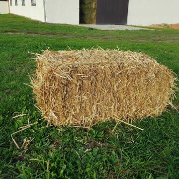
Kleine HD-Ballen Heu
Weil im Schönbuch
Sabine-Dettinger
@Sabine-Dettinger
Heu
Empfänger lädt ab
Kleinballen/HD-Ballen
Bio
Regenfrei
2 weitere...
B+
Deprecated: Creation of dynamic property Zend_View_Helper_Ads::$adLink is deprecated in /var/www/stall-frei/htdocs/staging.stall-frei.de/library/Psf/View/Helper/Ads.php on line 108

Paddockbox in kleiner Stallgemeinschaft frei
Rutesheim
Carolin-Hoerning
@Carolin-Hoerning
Wir sind ein kleiner Stall mit nur 13 Boxen in Rutesheim.
Aktuell haben wir eine Paddockbox frei.
neu
R
Leider kein Vorschaubild
Leider kein Vorschaubild
Heu- und Luzernecobs
Holzgerlingen
Schlosshof-Holzgerlingen
@Schlosshof-Holzgerlingen
Einstreu
Pellets
Regenfrei
Wird verladen
1 weitere...
B+

Heu Kleinballen 1. Schnitt - höchste Qualität
Weissach im Tal
Micha
@Micha3
Heu
Empfänger lädt ab
Kleinballen/HD-Ballen
Bio
Regenfrei
2 weitere...
aktuell
B+
Leider kein Vorschaubild
Leider kein Vorschaubild
heu 2025 heu 2ter schnitt 2025
Maisach
Reitstall Thurner
@ReitstallThurner
Heu
Empfänger lädt ab
Rundballen
Regenfrei
3 weitere...
B+
Leider kein Vorschaubild
Leider kein Vorschaubild
HEUCOBS/GRASCOBSMenge in kg Preis 0,75€/kg im Sa...
Starnberg
Reiterhof-Klim
@Reiterhof-Klim
Futter
Pellets
Abholung
B+
Leider kein Vorschaubild
Leider kein Vorschaubild
Heu zu verkaufen
Bad Rappenau
Uwe Wolf
@Uwe_Wolf
Heu
Empfänger lädt ab
Rundballen
Regenfrei
2 weitere...
B+

10 Rb Heu/15 RB Öhmd/15 RB Stroh
Helmstadt
Juergen
@Juergen77
Einstreu
Empfänger lädt ab
Rundballen
Regenfrei
2 weitere...
B+

Das Beste für die Hufe
Mechtersen
STALL-FREIde Marketing
@STALL-FREI-Marketing
Hufschmiede und Hufpfleger in Ihrer Nähe

HD-Heuballen, 1. Schnitt & 2. Schnitt
Hilpoltstein
KnollmeyerBallen
@KnollmeyerBallen
Heu
Lieferant entlädt
Kleinballen/HD-Ballen
Regenfrei
3 weitere...
B+
HD-Strohballen, Gersten-, Dinkel- und Weizenstroh
Hilpoltstein
KnollmeyerBallen
@KnollmeyerBallen
Einstreu
Lieferant entlädt
Kleinballen/HD-Ballen
Regenfrei
3 weitere...
B+
Deprecated: Creation of dynamic property Zend_View::$pageCount is deprecated in /var/www/stall-frei/htdocs/staging.stall-frei.de/library/vendor/shardj/zf1-future/library/Zend/View/Abstract.php on line 308
Deprecated: Creation of dynamic property Zend_View::$itemCountPerPage is deprecated in /var/www/stall-frei/htdocs/staging.stall-frei.de/library/vendor/shardj/zf1-future/library/Zend/View/Abstract.php on line 308
Deprecated: Creation of dynamic property Zend_View::$first is deprecated in /var/www/stall-frei/htdocs/staging.stall-frei.de/library/vendor/shardj/zf1-future/library/Zend/View/Abstract.php on line 308
Deprecated: Creation of dynamic property Zend_View::$current is deprecated in /var/www/stall-frei/htdocs/staging.stall-frei.de/library/vendor/shardj/zf1-future/library/Zend/View/Abstract.php on line 308
Deprecated: Creation of dynamic property Zend_View::$last is deprecated in /var/www/stall-frei/htdocs/staging.stall-frei.de/library/vendor/shardj/zf1-future/library/Zend/View/Abstract.php on line 308
Deprecated: Creation of dynamic property Zend_View::$previous is deprecated in /var/www/stall-frei/htdocs/staging.stall-frei.de/library/vendor/shardj/zf1-future/library/Zend/View/Abstract.php on line 308
Deprecated: Creation of dynamic property Zend_View::$next is deprecated in /var/www/stall-frei/htdocs/staging.stall-frei.de/library/vendor/shardj/zf1-future/library/Zend/View/Abstract.php on line 308
Deprecated: Creation of dynamic property Zend_View::$pagesInRange is deprecated in /var/www/stall-frei/htdocs/staging.stall-frei.de/library/vendor/shardj/zf1-future/library/Zend/View/Abstract.php on line 308
Deprecated: Creation of dynamic property Zend_View::$firstPageInRange is deprecated in /var/www/stall-frei/htdocs/staging.stall-frei.de/library/vendor/shardj/zf1-future/library/Zend/View/Abstract.php on line 308
Deprecated: Creation of dynamic property Zend_View::$lastPageInRange is deprecated in /var/www/stall-frei/htdocs/staging.stall-frei.de/library/vendor/shardj/zf1-future/library/Zend/View/Abstract.php on line 308
Deprecated: Creation of dynamic property Zend_View::$currentItemCount is deprecated in /var/www/stall-frei/htdocs/staging.stall-frei.de/library/vendor/shardj/zf1-future/library/Zend/View/Abstract.php on line 308
Deprecated: Creation of dynamic property Zend_View::$totalItemCount is deprecated in /var/www/stall-frei/htdocs/staging.stall-frei.de/library/vendor/shardj/zf1-future/library/Zend/View/Abstract.php on line 308
Deprecated: Creation of dynamic property Zend_View::$firstItemNumber is deprecated in /var/www/stall-frei/htdocs/staging.stall-frei.de/library/vendor/shardj/zf1-future/library/Zend/View/Abstract.php on line 308
Deprecated: Creation of dynamic property Zend_View::$lastItemNumber is deprecated in /var/www/stall-frei/htdocs/staging.stall-frei.de/library/vendor/shardj/zf1-future/library/Zend/View/Abstract.php on line 308
Deprecated: Creation of dynamic property Zend_View::$router is deprecated in /var/www/stall-frei/htdocs/staging.stall-frei.de/library/vendor/shardj/zf1-future/library/Zend/View/Abstract.php on line 308
Deprecated: Creation of dynamic property Zend_View::$urlParams is deprecated in /var/www/stall-frei/htdocs/staging.stall-frei.de/library/vendor/shardj/zf1-future/library/Zend/View/Abstract.php on line 308
Deprecated: Creation of dynamic property Zend_View::$showAds is deprecated in /var/www/stall-frei/htdocs/staging.stall-frei.de/library/vendor/shardj/zf1-future/library/Zend/View/Abstract.php on line 308
Deprecated: Creation of dynamic property Zend_View::$objectIds is deprecated in /var/www/stall-frei/htdocs/staging.stall-frei.de/library/vendor/shardj/zf1-future/library/Zend/View/Abstract.php on line 308
Deprecated: Creation of dynamic property Zend_View::$showNavbar is deprecated in /var/www/stall-frei/htdocs/staging.stall-frei.de/library/vendor/shardj/zf1-future/library/Zend/View/Abstract.php on line 308
Deprecated: Creation of dynamic property Zend_View::$showBreadcrumb is deprecated in /var/www/stall-frei/htdocs/staging.stall-frei.de/library/vendor/shardj/zf1-future/library/Zend/View/Abstract.php on line 308
Deprecated: Creation of dynamic property Zend_View::$showFooter is deprecated in /var/www/stall-frei/htdocs/staging.stall-frei.de/library/vendor/shardj/zf1-future/library/Zend/View/Abstract.php on line 308
Deprecated: Creation of dynamic property Zend_View::$showInternalAds is deprecated in /var/www/stall-frei/htdocs/staging.stall-frei.de/library/vendor/shardj/zf1-future/library/Zend/View/Abstract.php on line 308
Deprecated: Creation of dynamic property Zend_View::$blNoContent is deprecated in /var/www/stall-frei/htdocs/staging.stall-frei.de/library/vendor/shardj/zf1-future/library/Zend/View/Abstract.php on line 308
Deprecated: Creation of dynamic property Zend_View::$sMetaDesc is deprecated in /var/www/stall-frei/htdocs/staging.stall-frei.de/library/vendor/shardj/zf1-future/library/Zend/View/Abstract.php on line 308
Deprecated: Creation of dynamic property Zend_View::$useGmaps is deprecated in /var/www/stall-frei/htdocs/staging.stall-frei.de/library/vendor/shardj/zf1-future/library/Zend/View/Abstract.php on line 308
Deprecated: Creation of dynamic property Zend_View::$touches is deprecated in /var/www/stall-frei/htdocs/staging.stall-frei.de/library/vendor/shardj/zf1-future/library/Zend/View/Abstract.php on line 308
Deprecated: Creation of dynamic property Zend_View::$oProject is deprecated in /var/www/stall-frei/htdocs/staging.stall-frei.de/library/vendor/shardj/zf1-future/library/Zend/View/Abstract.php on line 308
Deprecated: Creation of dynamic property Zend_View::$pageHeadline is deprecated in /var/www/stall-frei/htdocs/staging.stall-frei.de/library/vendor/shardj/zf1-future/library/Zend/View/Abstract.php on line 308
Deprecated: Creation of dynamic property Zend_View::$disableLocationField is deprecated in /var/www/stall-frei/htdocs/staging.stall-frei.de/library/vendor/shardj/zf1-future/library/Zend/View/Abstract.php on line 308
Deprecated: Creation of dynamic property Zend_View::$isSearch is deprecated in /var/www/stall-frei/htdocs/staging.stall-frei.de/library/vendor/shardj/zf1-future/library/Zend/View/Abstract.php on line 308
Deprecated: Creation of dynamic property Zend_View::$pageTitle is deprecated in /var/www/stall-frei/htdocs/staging.stall-frei.de/library/vendor/shardj/zf1-future/library/Zend/View/Abstract.php on line 308
Deprecated: Creation of dynamic property Psf_Form_Element_Text::$class is deprecated in /var/www/stall-frei/htdocs/staging.stall-frei.de/library/vendor/shardj/zf1-future/library/Zend/Form/Element.php on line 874
Deprecated: Creation of dynamic property Psf_Form_Element_Text::$size is deprecated in /var/www/stall-frei/htdocs/staging.stall-frei.de/library/vendor/shardj/zf1-future/library/Zend/Form/Element.php on line 874
Deprecated: Creation of dynamic property Psf_Form_Element_Text::$placeholder is deprecated in /var/www/stall-frei/htdocs/staging.stall-frei.de/library/vendor/shardj/zf1-future/library/Zend/Form/Element.php on line 874
Deprecated: Creation of dynamic property Psf_Form_Element_Hidden::$class is deprecated in /var/www/stall-frei/htdocs/staging.stall-frei.de/library/vendor/shardj/zf1-future/library/Zend/Form/Element.php on line 874
Deprecated: Creation of dynamic property Psf_Form_Element_Hidden::$class is deprecated in /var/www/stall-frei/htdocs/staging.stall-frei.de/library/vendor/shardj/zf1-future/library/Zend/Form/Element.php on line 874
Deprecated: Creation of dynamic property Psf_Form_Element_Hidden::$class is deprecated in /var/www/stall-frei/htdocs/staging.stall-frei.de/library/vendor/shardj/zf1-future/library/Zend/Form/Element.php on line 874
Deprecated: Creation of dynamic property Psf_Form_Element_Hidden::$class is deprecated in /var/www/stall-frei/htdocs/staging.stall-frei.de/library/vendor/shardj/zf1-future/library/Zend/Form/Element.php on line 874
Deprecated: Creation of dynamic property Psf_Form_Element_Select::$class is deprecated in /var/www/stall-frei/htdocs/staging.stall-frei.de/library/vendor/shardj/zf1-future/library/Zend/Form/Element.php on line 874
Deprecated: Creation of dynamic property Psf_Form_Element_Select::$class is deprecated in /var/www/stall-frei/htdocs/staging.stall-frei.de/library/vendor/shardj/zf1-future/library/Zend/Form/Element.php on line 874
Deprecated: Creation of dynamic property Psf_Form_Element_Select::$class is deprecated in /var/www/stall-frei/htdocs/staging.stall-frei.de/library/vendor/shardj/zf1-future/library/Zend/Form/Element.php on line 874
Deprecated: Creation of dynamic property Psf_Form_Element_Select::$class is deprecated in /var/www/stall-frei/htdocs/staging.stall-frei.de/library/vendor/shardj/zf1-future/library/Zend/Form/Element.php on line 874
Deprecated: Creation of dynamic property Zend_View::$sort is deprecated in /var/www/stall-frei/htdocs/staging.stall-frei.de/library/vendor/shardj/zf1-future/library/Zend/View/Abstract.php on line 308
Deprecated: Creation of dynamic property Zend_View::$searchLocation is deprecated in /var/www/stall-frei/htdocs/staging.stall-frei.de/library/vendor/shardj/zf1-future/library/Zend/View/Abstract.php on line 308
Deprecated: Creation of dynamic property Zend_View::$locationHint is deprecated in /var/www/stall-frei/htdocs/staging.stall-frei.de/library/vendor/shardj/zf1-future/library/Zend/View/Abstract.php on line 308
Psf_GeoCoder_Abstract::getLocation: Auf der Au Get Location CachedOrLive
Psf_GeoCoder_Abstract::getCachedOrLive: Auf der Au
Psf_GeoCoder_Abstract::convertLocationResult
{"documentation":"https:\/\/opencagedata.com\/api","licenses":[{"name":"see attribution guide","url":"https:\/\/opencagedata.com\/credits"}],"results":[{"bounds":{"northeast":{"lat":48.2763073,"lng":9.8932157},"southwest":{"lat":48.2762073,"lng":9.8931157}},"components":{"ISO_3166-1_alpha-2":"DE","ISO_3166-1_alpha-3":"DEU","ISO_3166-2":["DE-BW"],"_category":"building","_normalized_city":"Achstetten","_type":"building","city":"Achstetten","continent":"Europe","country":"Deutschland","country_code":"de","county":"Landkreis Biberach","isolated_dwelling":"Auf der Au","municipality":"VVG der Stadt Laupheim","political_union":"European Union","postcode":"88480","state":"Baden-W\u00fcrttemberg","state_code":"BW"},"confidence":10,"formatted":"Auf der Au, 88480 Achstetten, Deutschland","geometry":{"lat":48.2762573,"lng":9.8931657}},{"bounds":{"northeast":{"lat":49.1723373,"lng":8.8538994},"southwest":{"lat":49.168377,"lng":8.8445374}},"components":{"ISO_3166-1_alpha-2":"DE","ISO_3166-1_alpha-3":"DEU","ISO_3166-2":["DE-BW"],"_category":"agriculture","_normalized_city":"Eppingen","_type":"vineyard","continent":"Europe","country":"Deutschland","country_code":"de","county":"Landkreis Heilbronn","hamlet":"Elsenztalsiedlung","municipality":"VVG der Stadt Eppingen","political_union":"European Union","postcode":"75031","state":"Baden-W\u00fcrttemberg","state_code":"BW","town":"Eppingen","village":"Elsenz","vineyard":"Auf der Au"},"confidence":9,"formatted":"Auf der Au, Elsenztalsiedlung, 75031 Elsenz, Deutschland","geometry":{"lat":49.170316,"lng":8.84856}},{"bounds":{"northeast":{"lat":47.6969292,"lng":14.6294982},"southwest":{"lat":47.6769292,"lng":14.6094982}},"components":{"ISO_3166-1_alpha-2":"AT","ISO_3166-1_alpha-3":"AUT","ISO_3166-2":["AT-6"],"_category":"place","_normalized_city":"Sankt Gallen","_type":"hamlet","continent":"Europe","country":"\u00d6sterreich","country_code":"at","county":"Bezirk Liezen","hamlet":"Steinberg","neighbourhood":"Auf der Au","political_union":"European Union","postcode":"8933","state":"Steiermark","state_code":"6","village":"Sankt Gallen"},"confidence":8,"formatted":"Steinberg, 8933 Sankt Gallen, \u00d6sterreich","geometry":{"lat":47.6869292,"lng":14.6194982}},{"bounds":{"northeast":{"lat":48.4702878,"lng":7.6862314},"southwest":{"lat":48.4502878,"lng":7.6662314}},"components":{"ISO_3166-1_alpha-2":"FR","ISO_3166-1_alpha-3":"FRA","ISO_3166-2":["FR-GES","FR-6AE","FR-67"],"_category":"place","_normalized_city":"Nordhausen","_type":"hamlet","continent":"Europe","country":"Frankreich","country_code":"fr","county":"Unterelsass","local_authority":"Communaut\u00e9 de communes du Canton d'Erstein","locality":"Auf der Au","municipality":"Schlettstadt-Erstein","political_union":"European Union","postcode":"67150","region":"Metropolitanes Frankreich","state":"Grand Est","state_code":"GES","state_district":"Collectivit\u00e9 europ\u00e9enne d'Alsace","village":"Nordhausen"},"confidence":8,"formatted":"67150 Nordhausen, Frankreich","geometry":{"lat":48.4602878,"lng":7.6762314}},{"bounds":{"northeast":{"lat":48.6833824,"lng":7.7288235},"southwest":{"lat":48.6633824,"lng":7.7088235}},"components":{"ISO_3166-1_alpha-2":"FR","ISO_3166-1_alpha-3":"FRA","ISO_3166-2":["FR-GES","FR-6AE","FR-67"],"_category":"place","_normalized_city":"Vendenheim","_type":"hamlet","continent":"Europe","country":"Frankreich","country_code":"fr","county":"Unterelsass","local_authority":"Strasbourg Eurom\u00e9tropole","locality":"Auf der Au","municipality":"Stra\u00dfburg","political_union":"European Union","postcode":"67550","region":"Metropolitanes Frankreich","state":"Grand Est","state_code":"GES","state_district":"Collectivit\u00e9 europ\u00e9enne d'Alsace","village":"Vendenheim"},"confidence":8,"formatted":"67550 Vendenheim, Frankreich","geometry":{"lat":48.6733824,"lng":7.7188235}},{"bounds":{"northeast":{"lat":50.2891465,"lng":7.6451712},"southwest":{"lat":50.2691465,"lng":7.6251712}},"components":{"ISO_3166-1_alpha-2":"DE","ISO_3166-1_alpha-3":"DEU","ISO_3166-2":["DE-RP"],"_category":"place","_normalized_city":"Braubach","_type":"hamlet","continent":"Europe","country":"Deutschland","country_code":"de","county":"Rhein-Lahn-Kreis","locality":"Auf der Au","municipality":"Loreley","political_union":"European Union","postcode":"56338","state":"Rheinland-Pfalz","state_code":"RP","suburb":"Nord","town":"Braubach"},"confidence":8,"formatted":"Auf der Au, 56338 Braubach, Deutschland","geometry":{"lat":50.2791465,"lng":7.6351712}},{"bounds":{"northeast":{"lat":47.4947765,"lng":7.3975589},"southwest":{"lat":47.4747765,"lng":7.3775589}},"components":{"ISO_3166-1_alpha-2":"FR","ISO_3166-1_alpha-3":"FRA","ISO_3166-2":["FR-GES","FR-6AE","FR-68"],"_category":"place","_normalized_city":"Oltingen","_type":"hamlet","continent":"Europe","country":"Frankreich","country_code":"fr","county":"Oberelsass","local_authority":"Communaut\u00e9 de communes Sundgau","locality":"Auf der Au","municipality":"Altkirch","political_union":"European Union","postcode":"68480","region":"Metropolitanes Frankreich","state":"Grand Est","state_code":"GES","state_district":"Collectivit\u00e9 europ\u00e9enne d'Alsace","village":"Oltingen"},"confidence":8,"formatted":"68480 Oltingen, Frankreich","geometry":{"lat":47.4847765,"lng":7.3875589}},{"bounds":{"northeast":{"lat":47.4744652,"lng":7.3923087},"southwest":{"lat":47.4544652,"lng":7.3723087}},"components":{"ISO_3166-1_alpha-2":"FR","ISO_3166-1_alpha-3":"FRA","ISO_3166-2":["FR-GES","FR-6AE","FR-68"],"_category":"place","_normalized_city":"Lutter","_type":"hamlet","continent":"Europe","country":"Frankreich","country_code":"fr","county":"Oberelsass","local_authority":"Communaut\u00e9 de communes Sundgau","locality":"Auf der Au","municipality":"Altkirch","political_union":"European Union","postcode":"68480","region":"Metropolitanes Frankreich","state":"Grand Est","state_code":"GES","state_district":"Collectivit\u00e9 europ\u00e9enne d'Alsace","village":"Lutter"},"confidence":8,"formatted":"68480 Lutter, Frankreich","geometry":{"lat":47.4644652,"lng":7.3823087}},{"bounds":{"northeast":{"lat":49.9832618,"lng":8.9958115},"southwest":{"lat":49.9632618,"lng":8.9758115}},"components":{"ISO_3166-1_alpha-2":"DE","ISO_3166-1_alpha-3":"DEU","ISO_3166-2":["DE-HE"],"_category":"place","_normalized_city":"Harreshausen","_type":"hamlet","continent":"Europe","country":"Deutschland","country_code":"de","county":"Landkreis Darmstadt-Dieburg","locality":"Auf der Au","municipality":"Babenhausen","political_union":"European Union","postcode":"64832","state":"Hessen","state_code":"HE","village":"Harreshausen"},"confidence":8,"formatted":"Auf der Au, 64832 Harreshausen, Deutschland","geometry":{"lat":49.9732618,"lng":8.9858115}},{"bounds":{"northeast":{"lat":49.7137205,"lng":8.6757389},"southwest":{"lat":49.6937205,"lng":8.6557389}},"components":{"ISO_3166-1_alpha-2":"DE","ISO_3166-1_alpha-3":"DEU","ISO_3166-2":["DE-HE"],"_category":"place","_normalized_city":"Elmshausen","_type":"hamlet","continent":"Europe","country":"Deutschland","country_code":"de","county":"Kreis Bergstra\u00dfe","locality":"Auf der Au","municipality":"Lautertal (Odenwald)","political_union":"European Union","postcode":"64686","state":"Hessen","state_code":"HE","village":"Elmshausen"},"confidence":8,"formatted":"Auf der Au, 64686 Elmshausen, Deutschland","geometry":{"lat":49.7037205,"lng":8.6657389}}],"status":{"code":200,"message":"OK"},"stay_informed":{"blog":"https:\/\/blog.opencagedata.com","mastodon":"https:\/\/en.osm.town\/@opencage"},"thanks":"For using an OpenCage API","timestamp":{"created_http":"Sat, 07 Feb 2026 17:27:33 GMT","created_unix":1770485253},"total_results":10}Array
(
[0] => stdClass Object
(
[bounds] => stdClass Object
(
[northeast] => stdClass Object
(
[lat] => 48.2763073
[lng] => 9.8932157
)
[southwest] => stdClass Object
(
[lat] => 48.2762073
[lng] => 9.8931157
)
)
[components] => stdClass Object
(
[ISO_3166-1_alpha-2] => DE
[ISO_3166-1_alpha-3] => DEU
[ISO_3166-2] => Array
(
[0] => DE-BW
)
[_category] => building
[_normalized_city] => Achstetten
[_type] => building
[city] => Achstetten
[continent] => Europe
[country] => Deutschland
[country_code] => de
[county] => Landkreis Biberach
[isolated_dwelling] => Auf der Au
[municipality] => VVG der Stadt Laupheim
[political_union] => European Union
[postcode] => 88480
[state] => Baden-Württemberg
[state_code] => BW
)
[confidence] => 10
[formatted] => Auf der Au, 88480 Achstetten, Deutschland
[geometry] => stdClass Object
(
[lat] => 48.2762573
[lng] => 9.8931657
)
)
[1] => stdClass Object
(
[bounds] => stdClass Object
(
[northeast] => stdClass Object
(
[lat] => 49.1723373
[lng] => 8.8538994
)
[southwest] => stdClass Object
(
[lat] => 49.168377
[lng] => 8.8445374
)
)
[components] => stdClass Object
(
[ISO_3166-1_alpha-2] => DE
[ISO_3166-1_alpha-3] => DEU
[ISO_3166-2] => Array
(
[0] => DE-BW
)
[_category] => agriculture
[_normalized_city] => Eppingen
[_type] => vineyard
[continent] => Europe
[country] => Deutschland
[country_code] => de
[county] => Landkreis Heilbronn
[hamlet] => Elsenztalsiedlung
[municipality] => VVG der Stadt Eppingen
[political_union] => European Union
[postcode] => 75031
[state] => Baden-Württemberg
[state_code] => BW
[town] => Eppingen
[village] => Elsenz
[vineyard] => Auf der Au
)
[confidence] => 9
[formatted] => Auf der Au, Elsenztalsiedlung, 75031 Elsenz, Deutschland
[geometry] => stdClass Object
(
[lat] => 49.170316
[lng] => 8.84856
)
)
[2] => stdClass Object
(
[bounds] => stdClass Object
(
[northeast] => stdClass Object
(
[lat] => 47.6969292
[lng] => 14.6294982
)
[southwest] => stdClass Object
(
[lat] => 47.6769292
[lng] => 14.6094982
)
)
[components] => stdClass Object
(
[ISO_3166-1_alpha-2] => AT
[ISO_3166-1_alpha-3] => AUT
[ISO_3166-2] => Array
(
[0] => AT-6
)
[_category] => place
[_normalized_city] => Sankt Gallen
[_type] => hamlet
[continent] => Europe
[country] => Österreich
[country_code] => at
[county] => Bezirk Liezen
[hamlet] => Steinberg
[neighbourhood] => Auf der Au
[political_union] => European Union
[postcode] => 8933
[state] => Steiermark
[state_code] => 6
[village] => Sankt Gallen
)
[confidence] => 8
[formatted] => Steinberg, 8933 Sankt Gallen, Österreich
[geometry] => stdClass Object
(
[lat] => 47.6869292
[lng] => 14.6194982
)
)
[3] => stdClass Object
(
[bounds] => stdClass Object
(
[northeast] => stdClass Object
(
[lat] => 48.4702878
[lng] => 7.6862314
)
[southwest] => stdClass Object
(
[lat] => 48.4502878
[lng] => 7.6662314
)
)
[components] => stdClass Object
(
[ISO_3166-1_alpha-2] => FR
[ISO_3166-1_alpha-3] => FRA
[ISO_3166-2] => Array
(
[0] => FR-GES
[1] => FR-6AE
[2] => FR-67
)
[_category] => place
[_normalized_city] => Nordhausen
[_type] => hamlet
[continent] => Europe
[country] => Frankreich
[country_code] => fr
[county] => Unterelsass
[local_authority] => Communauté de communes du Canton d'Erstein
[locality] => Auf der Au
[municipality] => Schlettstadt-Erstein
[political_union] => European Union
[postcode] => 67150
[region] => Metropolitanes Frankreich
[state] => Grand Est
[state_code] => GES
[state_district] => Collectivité européenne d'Alsace
[village] => Nordhausen
)
[confidence] => 8
[formatted] => 67150 Nordhausen, Frankreich
[geometry] => stdClass Object
(
[lat] => 48.4602878
[lng] => 7.6762314
)
)
[4] => stdClass Object
(
[bounds] => stdClass Object
(
[northeast] => stdClass Object
(
[lat] => 48.6833824
[lng] => 7.7288235
)
[southwest] => stdClass Object
(
[lat] => 48.6633824
[lng] => 7.7088235
)
)
[components] => stdClass Object
(
[ISO_3166-1_alpha-2] => FR
[ISO_3166-1_alpha-3] => FRA
[ISO_3166-2] => Array
(
[0] => FR-GES
[1] => FR-6AE
[2] => FR-67
)
[_category] => place
[_normalized_city] => Vendenheim
[_type] => hamlet
[continent] => Europe
[country] => Frankreich
[country_code] => fr
[county] => Unterelsass
[local_authority] => Strasbourg Eurométropole
[locality] => Auf der Au
[municipality] => Straßburg
[political_union] => European Union
[postcode] => 67550
[region] => Metropolitanes Frankreich
[state] => Grand Est
[state_code] => GES
[state_district] => Collectivité européenne d'Alsace
[village] => Vendenheim
)
[confidence] => 8
[formatted] => 67550 Vendenheim, Frankreich
[geometry] => stdClass Object
(
[lat] => 48.6733824
[lng] => 7.7188235
)
)
[5] => stdClass Object
(
[bounds] => stdClass Object
(
[northeast] => stdClass Object
(
[lat] => 50.2891465
[lng] => 7.6451712
)
[southwest] => stdClass Object
(
[lat] => 50.2691465
[lng] => 7.6251712
)
)
[components] => stdClass Object
(
[ISO_3166-1_alpha-2] => DE
[ISO_3166-1_alpha-3] => DEU
[ISO_3166-2] => Array
(
[0] => DE-RP
)
[_category] => place
[_normalized_city] => Braubach
[_type] => hamlet
[continent] => Europe
[country] => Deutschland
[country_code] => de
[county] => Rhein-Lahn-Kreis
[locality] => Auf der Au
[municipality] => Loreley
[political_union] => European Union
[postcode] => 56338
[state] => Rheinland-Pfalz
[state_code] => RP
[suburb] => Nord
[town] => Braubach
)
[confidence] => 8
[formatted] => Auf der Au, 56338 Braubach, Deutschland
[geometry] => stdClass Object
(
[lat] => 50.2791465
[lng] => 7.6351712
)
)
[6] => stdClass Object
(
[bounds] => stdClass Object
(
[northeast] => stdClass Object
(
[lat] => 47.4947765
[lng] => 7.3975589
)
[southwest] => stdClass Object
(
[lat] => 47.4747765
[lng] => 7.3775589
)
)
[components] => stdClass Object
(
[ISO_3166-1_alpha-2] => FR
[ISO_3166-1_alpha-3] => FRA
[ISO_3166-2] => Array
(
[0] => FR-GES
[1] => FR-6AE
[2] => FR-68
)
[_category] => place
[_normalized_city] => Oltingen
[_type] => hamlet
[continent] => Europe
[country] => Frankreich
[country_code] => fr
[county] => Oberelsass
[local_authority] => Communauté de communes Sundgau
[locality] => Auf der Au
[municipality] => Altkirch
[political_union] => European Union
[postcode] => 68480
[region] => Metropolitanes Frankreich
[state] => Grand Est
[state_code] => GES
[state_district] => Collectivité européenne d'Alsace
[village] => Oltingen
)
[confidence] => 8
[formatted] => 68480 Oltingen, Frankreich
[geometry] => stdClass Object
(
[lat] => 47.4847765
[lng] => 7.3875589
)
)
[7] => stdClass Object
(
[bounds] => stdClass Object
(
[northeast] => stdClass Object
(
[lat] => 47.4744652
[lng] => 7.3923087
)
[southwest] => stdClass Object
(
[lat] => 47.4544652
[lng] => 7.3723087
)
)
[components] => stdClass Object
(
[ISO_3166-1_alpha-2] => FR
[ISO_3166-1_alpha-3] => FRA
[ISO_3166-2] => Array
(
[0] => FR-GES
[1] => FR-6AE
[2] => FR-68
)
[_category] => place
[_normalized_city] => Lutter
[_type] => hamlet
[continent] => Europe
[country] => Frankreich
[country_code] => fr
[county] => Oberelsass
[local_authority] => Communauté de communes Sundgau
[locality] => Auf der Au
[municipality] => Altkirch
[political_union] => European Union
[postcode] => 68480
[region] => Metropolitanes Frankreich
[state] => Grand Est
[state_code] => GES
[state_district] => Collectivité européenne d'Alsace
[village] => Lutter
)
[confidence] => 8
[formatted] => 68480 Lutter, Frankreich
[geometry] => stdClass Object
(
[lat] => 47.4644652
[lng] => 7.3823087
)
)
[8] => stdClass Object
(
[bounds] => stdClass Object
(
[northeast] => stdClass Object
(
[lat] => 49.9832618
[lng] => 8.9958115
)
[southwest] => stdClass Object
(
[lat] => 49.9632618
[lng] => 8.9758115
)
)
[components] => stdClass Object
(
[ISO_3166-1_alpha-2] => DE
[ISO_3166-1_alpha-3] => DEU
[ISO_3166-2] => Array
(
[0] => DE-HE
)
[_category] => place
[_normalized_city] => Harreshausen
[_type] => hamlet
[continent] => Europe
[country] => Deutschland
[country_code] => de
[county] => Landkreis Darmstadt-Dieburg
[locality] => Auf der Au
[municipality] => Babenhausen
[political_union] => European Union
[postcode] => 64832
[state] => Hessen
[state_code] => HE
[village] => Harreshausen
)
[confidence] => 8
[formatted] => Auf der Au, 64832 Harreshausen, Deutschland
[geometry] => stdClass Object
(
[lat] => 49.9732618
[lng] => 8.9858115
)
)
[9] => stdClass Object
(
[bounds] => stdClass Object
(
[northeast] => stdClass Object
(
[lat] => 49.7137205
[lng] => 8.6757389
)
[southwest] => stdClass Object
(
[lat] => 49.6937205
[lng] => 8.6557389
)
)
[components] => stdClass Object
(
[ISO_3166-1_alpha-2] => DE
[ISO_3166-1_alpha-3] => DEU
[ISO_3166-2] => Array
(
[0] => DE-HE
)
[_category] => place
[_normalized_city] => Elmshausen
[_type] => hamlet
[continent] => Europe
[country] => Deutschland
[country_code] => de
[county] => Kreis Bergstraße
[locality] => Auf der Au
[municipality] => Lautertal (Odenwald)
[political_union] => European Union
[postcode] => 64686
[state] => Hessen
[state_code] => HE
[village] => Elmshausen
)
[confidence] => 8
[formatted] => Auf der Au, 64686 Elmshausen, Deutschland
[geometry] => stdClass Object
(
[lat] => 49.7037205
[lng] => 8.6657389
)
)
)
Psf_GeoCoder_OpenCageData::getKeyMap: 0
stdClass Object
(
    [bounds] => stdClass Object
        (
            [northeast] => stdClass Object
                (
                    [lat] => 48.2763073
                    [lng] => 9.8932157
                )

            [southwest] => stdClass Object
                (
                    [lat] => 48.2762073
                    [lng] => 9.8931157
                )

        )

    [components] => stdClass Object
        (
            [ISO_3166-1_alpha-2] => DE
            [ISO_3166-1_alpha-3] => DEU
            [ISO_3166-2] => Array
                (
                    [0] => DE-BW
                )

            [_category] => building
            [_normalized_city] => Achstetten
            [_type] => building
            [city] => Achstetten
            [continent] => Europe
            [country] => Deutschland
            [country_code] => de
            [county] => Landkreis Biberach
            [isolated_dwelling] => Auf der Au
            [municipality] => VVG der Stadt Laupheim
            [political_union] => European Union
            [postcode] => 88480
            [state] => Baden-Württemberg
            [state_code] => BW
        )

    [confidence] => 10
    [formatted] => Auf der Au, 88480 Achstetten, Deutschland
    [geometry] => stdClass Object
        (
            [lat] => 48.2762573
            [lng] => 9.8931657
        )

)
Psf_GeoCoder_OpenCageData::getCounty: Biberach
Psf_GeoCoder_OpenCageData::addMissingData REFETCH!
Array
(
    [address] => Auf der Au, 88480 Achstetten, Deutschland
    [type] => building
    [street] =>
    [city] => Achstetten
    [county] => Biberach
    [state] => Baden-Württemberg
    [zip] => 88480
    [country] => Deutschland
    [suburb] =>
    [countrycode] => de
    [latitude] => 48.2762573
    [longitude] => 9.8931657
    [accuracy] => 1
    [confidence] => 10
    [bounds] => stdClass Object
        (
            [northeast] => stdClass Object
                (
                    [lat] => 48.2763073
                    [lng] => 9.8932157
                )

            [southwest] => stdClass Object
                (
                    [lat] => 48.2762073
                    [lng] => 9.8931157
                )

        )

)
reformat!
Array
(
    [address] => Auf der Au, 88480 Achstetten, Deutschland
    [type] => building
    [street] =>
    [city] => Achstetten
    [county] => Biberach
    [state] => Baden-Württemberg
    [zip] => 88480
    [country] => Deutschland
    [suburb] =>
    [countrycode] => de
    [latitude] => 48.2762573
    [longitude] => 9.8931657
    [accuracy] => 1
    [confidence] => 10
    [bounds] => stdClass Object
        (
            [northeast] => stdClass Object
                (
                    [lat] => 48.2763073
                    [lng] => 9.8932157
                )

            [southwest] => stdClass Object
                (
                    [lat] => 48.2762073
                    [lng] => 9.8931157
                )

        )

    [place] => 88480 Achstetten, Baden-Württemberg
    [hash] => 75c89f104b3c5bdfb4a3c7d824ee49f7
)
Psf_GeoCoder_OpenCageData::getKeyMap: 1
stdClass Object
(
    [bounds] => stdClass Object
        (
            [northeast] => stdClass Object
                (
                    [lat] => 49.1723373
                    [lng] => 8.8538994
                )

            [southwest] => stdClass Object
                (
                    [lat] => 49.168377
                    [lng] => 8.8445374
                )

        )

    [components] => stdClass Object
        (
            [ISO_3166-1_alpha-2] => DE
            [ISO_3166-1_alpha-3] => DEU
            [ISO_3166-2] => Array
                (
                    [0] => DE-BW
                )

            [_category] => agriculture
            [_normalized_city] => Eppingen
            [_type] => vineyard
            [continent] => Europe
            [country] => Deutschland
            [country_code] => de
            [county] => Landkreis Heilbronn
            [hamlet] => Elsenztalsiedlung
            [municipality] => VVG der Stadt Eppingen
            [political_union] => European Union
            [postcode] => 75031
            [state] => Baden-Württemberg
            [state_code] => BW
            [town] => Eppingen
            [village] => Elsenz
            [vineyard] => Auf der Au
        )

    [confidence] => 9
    [formatted] => Auf der Au, Elsenztalsiedlung, 75031 Elsenz, Deutschland
    [geometry] => stdClass Object
        (
            [lat] => 49.170316
            [lng] => 8.84856
        )

)
Psf_GeoCoder_OpenCageData::getCounty: Heilbronn
Psf_GeoCoder_OpenCageData::addMissingData REFETCH!
Array
(
    [address] => Auf der Au, Elsenztalsiedlung, 75031 Elsenz, Deutschland
    [type] => vineyard
    [street] => Elsenztalsiedlung
    [city] => Eppingen
    [county] => Heilbronn
    [state] => Baden-Württemberg
    [zip] => 75031
    [country] => Deutschland
    [suburb] =>
    [countrycode] => de
    [latitude] => 49.170316
    [longitude] => 8.84856
    [accuracy] => 1
    [confidence] => 9
    [bounds] => stdClass Object
        (
            [northeast] => stdClass Object
                (
                    [lat] => 49.1723373
                    [lng] => 8.8538994
                )

            [southwest] => stdClass Object
                (
                    [lat] => 49.168377
                    [lng] => 8.8445374
                )

        )

)
reformat!
Array
(
    [address] => Elsenztalsiedlung, 75031 Eppingen
    [type] => vineyard
    [street] => Elsenztalsiedlung
    [city] => Eppingen
    [county] => Heilbronn
    [state] => Baden-Württemberg
    [zip] => 75031
    [country] => Deutschland
    [suburb] =>
    [countrycode] => de
    [latitude] => 49.170316
    [longitude] => 8.84856
    [accuracy] => 1
    [confidence] => 9
    [bounds] => stdClass Object
        (
            [northeast] => stdClass Object
                (
                    [lat] => 49.1723373
                    [lng] => 8.8538994
                )

            [southwest] => stdClass Object
                (
                    [lat] => 49.168377
                    [lng] => 8.8445374
                )

        )

    [place] => Elsenztalsiedlung, 75031 Eppingen, Baden-Württemberg
    [hash] => d95b287b44e7ca346b1bb38cae09a950
)
Psf_GeoCoder_OpenCageData::getKeyMap: 2
stdClass Object
(
    [bounds] => stdClass Object
        (
            [northeast] => stdClass Object
                (
                    [lat] => 47.6969292
                    [lng] => 14.6294982
                )

            [southwest] => stdClass Object
                (
                    [lat] => 47.6769292
                    [lng] => 14.6094982
                )

        )

    [components] => stdClass Object
        (
            [ISO_3166-1_alpha-2] => AT
            [ISO_3166-1_alpha-3] => AUT
            [ISO_3166-2] => Array
                (
                    [0] => AT-6
                )

            [_category] => place
            [_normalized_city] => Sankt Gallen
            [_type] => hamlet
            [continent] => Europe
            [country] => Österreich
            [country_code] => at
            [county] => Bezirk Liezen
            [hamlet] => Steinberg
            [neighbourhood] => Auf der Au
            [political_union] => European Union
            [postcode] => 8933
            [state] => Steiermark
            [state_code] => 6
            [village] => Sankt Gallen
        )

    [confidence] => 8
    [formatted] => Steinberg, 8933 Sankt Gallen, Österreich
    [geometry] => stdClass Object
        (
            [lat] => 47.6869292
            [lng] => 14.6194982
        )

)
Psf_GeoCoder_OpenCageData::getCounty: Bezirk Liezen
Psf_GeoCoder_OpenCageData::addMissingData REFETCH!
Array
(
    [address] => Steinberg, 8933 Sankt Gallen, Österreich
    [type] => hamlet
    [street] => Steinberg
    [city] => Sankt Gallen
    [county] => Bezirk Liezen
    [state] => Steiermark
    [zip] => 8933
    [country] => Österreich
    [suburb] =>
    [countrycode] => at
    [latitude] => 47.6869292
    [longitude] => 14.6194982
    [accuracy] => 1
    [confidence] => 8
    [bounds] => stdClass Object
        (
            [northeast] => stdClass Object
                (
                    [lat] => 47.6969292
                    [lng] => 14.6294982
                )

            [southwest] => stdClass Object
                (
                    [lat] => 47.6769292
                    [lng] => 14.6094982
                )

        )

)
reformat!
Array
(
    [address] => Steinberg, 8933 Sankt Gallen, Österreich
    [type] => hamlet
    [street] => Steinberg
    [city] => Sankt Gallen
    [county] => Bezirk Liezen
    [state] => Steiermark
    [zip] => 8933
    [country] => Österreich
    [suburb] =>
    [countrycode] => at
    [latitude] => 47.6869292
    [longitude] => 14.6194982
    [accuracy] => 1
    [confidence] => 8
    [bounds] => stdClass Object
        (
            [northeast] => stdClass Object
                (
                    [lat] => 47.6969292
                    [lng] => 14.6294982
                )

            [southwest] => stdClass Object
                (
                    [lat] => 47.6769292
                    [lng] => 14.6094982
                )

        )

    [place] => Steinberg, 8933 Sankt Gallen, Steiermark
    [hash] => 2cb0c3fd3ac87f9029aff4342ea60e79
)
Psf_GeoCoder_OpenCageData::getKeyMap: 3
stdClass Object
(
    [bounds] => stdClass Object
        (
            [northeast] => stdClass Object
                (
                    [lat] => 48.4702878
                    [lng] => 7.6862314
                )

            [southwest] => stdClass Object
                (
                    [lat] => 48.4502878
                    [lng] => 7.6662314
                )

        )

    [components] => stdClass Object
        (
            [ISO_3166-1_alpha-2] => FR
            [ISO_3166-1_alpha-3] => FRA
            [ISO_3166-2] => Array
                (
                    [0] => FR-GES
                    [1] => FR-6AE
                    [2] => FR-67
                )

            [_category] => place
            [_normalized_city] => Nordhausen
            [_type] => hamlet
            [continent] => Europe
            [country] => Frankreich
            [country_code] => fr
            [county] => Unterelsass
            [local_authority] => Communauté de communes du Canton d'Erstein
            [locality] => Auf der Au
            [municipality] => Schlettstadt-Erstein
            [political_union] => European Union
            [postcode] => 67150
            [region] => Metropolitanes Frankreich
            [state] => Grand Est
            [state_code] => GES
            [state_district] => Collectivité européenne d'Alsace
            [village] => Nordhausen
        )

    [confidence] => 8
    [formatted] => 67150 Nordhausen, Frankreich
    [geometry] => stdClass Object
        (
            [lat] => 48.4602878
            [lng] => 7.6762314
        )

)
Psf_GeoCoder_OpenCageData::getCounty: Unterelsass
Psf_GeoCoder_OpenCageData::addMissingData REFETCH!
Array
(
    [address] => 67150 Nordhausen, Frankreich
    [type] => hamlet
    [street] =>
    [city] => Nordhausen
    [county] => Unterelsass
    [state] => Grand Est
    [zip] => 67150
    [country] => Frankreich
    [suburb] =>
    [countrycode] => fr
    [latitude] => 48.4602878
    [longitude] => 7.6762314
    [accuracy] => 1
    [confidence] => 8
    [bounds] => stdClass Object
        (
            [northeast] => stdClass Object
                (
                    [lat] => 48.4702878
                    [lng] => 7.6862314
                )

            [southwest] => stdClass Object
                (
                    [lat] => 48.4502878
                    [lng] => 7.6662314
                )

        )

)
reformat!
Array
(
    [address] => 67150 Nordhausen, Frankreich
    [type] => hamlet
    [street] =>
    [city] => Nordhausen
    [county] => Unterelsass
    [state] => Grand Est
    [zip] => 67150
    [country] => Frankreich
    [suburb] =>
    [countrycode] => fr
    [latitude] => 48.4602878
    [longitude] => 7.6762314
    [accuracy] => 1
    [confidence] => 8
    [bounds] => stdClass Object
        (
            [northeast] => stdClass Object
                (
                    [lat] => 48.4702878
                    [lng] => 7.6862314
                )

            [southwest] => stdClass Object
                (
                    [lat] => 48.4502878
                    [lng] => 7.6662314
                )

        )

    [place] => 67150 Nordhausen, Grand Est
    [hash] => 57ca2f404166576d130a5d48ed379e1a
)
Psf_GeoCoder_OpenCageData::getKeyMap: 4
stdClass Object
(
    [bounds] => stdClass Object
        (
            [northeast] => stdClass Object
                (
                    [lat] => 48.6833824
                    [lng] => 7.7288235
                )

            [southwest] => stdClass Object
                (
                    [lat] => 48.6633824
                    [lng] => 7.7088235
                )

        )

    [components] => stdClass Object
        (
            [ISO_3166-1_alpha-2] => FR
            [ISO_3166-1_alpha-3] => FRA
            [ISO_3166-2] => Array
                (
                    [0] => FR-GES
                    [1] => FR-6AE
                    [2] => FR-67
                )

            [_category] => place
            [_normalized_city] => Vendenheim
            [_type] => hamlet
            [continent] => Europe
            [country] => Frankreich
            [country_code] => fr
            [county] => Unterelsass
            [local_authority] => Strasbourg Eurométropole
            [locality] => Auf der Au
            [municipality] => Straßburg
            [political_union] => European Union
            [postcode] => 67550
            [region] => Metropolitanes Frankreich
            [state] => Grand Est
            [state_code] => GES
            [state_district] => Collectivité européenne d'Alsace
            [village] => Vendenheim
        )

    [confidence] => 8
    [formatted] => 67550 Vendenheim, Frankreich
    [geometry] => stdClass Object
        (
            [lat] => 48.6733824
            [lng] => 7.7188235
        )

)
Psf_GeoCoder_OpenCageData::getCounty: Unterelsass
Psf_GeoCoder_OpenCageData::addMissingData REFETCH!
Array
(
    [address] => 67550 Vendenheim, Frankreich
    [type] => hamlet
    [street] =>
    [city] => Vendenheim
    [county] => Unterelsass
    [state] => Grand Est
    [zip] => 67550
    [country] => Frankreich
    [suburb] =>
    [countrycode] => fr
    [latitude] => 48.6733824
    [longitude] => 7.7188235
    [accuracy] => 1
    [confidence] => 8
    [bounds] => stdClass Object
        (
            [northeast] => stdClass Object
                (
                    [lat] => 48.6833824
                    [lng] => 7.7288235
                )

            [southwest] => stdClass Object
                (
                    [lat] => 48.6633824
                    [lng] => 7.7088235
                )

        )

)
reformat!
Array
(
    [address] => 67550 Vendenheim, Frankreich
    [type] => hamlet
    [street] =>
    [city] => Vendenheim
    [county] => Unterelsass
    [state] => Grand Est
    [zip] => 67550
    [country] => Frankreich
    [suburb] =>
    [countrycode] => fr
    [latitude] => 48.6733824
    [longitude] => 7.7188235
    [accuracy] => 1
    [confidence] => 8
    [bounds] => stdClass Object
        (
            [northeast] => stdClass Object
                (
                    [lat] => 48.6833824
                    [lng] => 7.7288235
                )

            [southwest] => stdClass Object
                (
                    [lat] => 48.6633824
                    [lng] => 7.7088235
                )

        )

    [place] => 67550 Vendenheim, Grand Est
    [hash] => fef37fadb056a5af73b16ea680f2ceac
)
Psf_GeoCoder_OpenCageData::getKeyMap: 5
stdClass Object
(
    [bounds] => stdClass Object
        (
            [northeast] => stdClass Object
                (
                    [lat] => 50.2891465
                    [lng] => 7.6451712
                )

            [southwest] => stdClass Object
                (
                    [lat] => 50.2691465
                    [lng] => 7.6251712
                )

        )

    [components] => stdClass Object
        (
            [ISO_3166-1_alpha-2] => DE
            [ISO_3166-1_alpha-3] => DEU
            [ISO_3166-2] => Array
                (
                    [0] => DE-RP
                )

            [_category] => place
            [_normalized_city] => Braubach
            [_type] => hamlet
            [continent] => Europe
            [country] => Deutschland
            [country_code] => de
            [county] => Rhein-Lahn-Kreis
            [locality] => Auf der Au
            [municipality] => Loreley
            [political_union] => European Union
            [postcode] => 56338
            [state] => Rheinland-Pfalz
            [state_code] => RP
            [suburb] => Nord
            [town] => Braubach
        )

    [confidence] => 8
    [formatted] => Auf der Au, 56338 Braubach, Deutschland
    [geometry] => stdClass Object
        (
            [lat] => 50.2791465
            [lng] => 7.6351712
        )

)
Psf_GeoCoder_OpenCageData::getCounty: Rhein-Lahn-Kreis
Psf_GeoCoder_OpenCageData::addMissingData REFETCH!
Array
(
    [address] => Auf der Au, 56338 Braubach, Deutschland
    [type] => hamlet
    [street] =>
    [city] => Braubach
    [county] => Rhein-Lahn-Kreis
    [state] => Rheinland-Pfalz
    [zip] => 56338
    [country] => Deutschland
    [suburb] => Nord
    [countrycode] => de
    [latitude] => 50.2791465
    [longitude] => 7.6351712
    [accuracy] => 1
    [confidence] => 8
    [bounds] => stdClass Object
        (
            [northeast] => stdClass Object
                (
                    [lat] => 50.2891465
                    [lng] => 7.6451712
                )

            [southwest] => stdClass Object
                (
                    [lat] => 50.2691465
                    [lng] => 7.6251712
                )

        )

)
reformat!
Array
(
    [address] => Auf der Au, 56338 Braubach, Deutschland
    [type] => hamlet
    [street] =>
    [city] => Braubach
    [county] => Rhein-Lahn-Kreis
    [state] => Rheinland-Pfalz
    [zip] => 56338
    [country] => Deutschland
    [suburb] => Nord
    [countrycode] => de
    [latitude] => 50.2791465
    [longitude] => 7.6351712
    [accuracy] => 1
    [confidence] => 8
    [bounds] => stdClass Object
        (
            [northeast] => stdClass Object
                (
                    [lat] => 50.2891465
                    [lng] => 7.6451712
                )

            [southwest] => stdClass Object
                (
                    [lat] => 50.2691465
                    [lng] => 7.6251712
                )

        )

    [place] => 56338 Braubach, Rheinland-Pfalz
    [hash] => e941c1c2b631b00b6dcb50e853ad398e
)
Psf_GeoCoder_OpenCageData::getKeyMap: 6
stdClass Object
(
    [bounds] => stdClass Object
        (
            [northeast] => stdClass Object
                (
                    [lat] => 47.4947765
                    [lng] => 7.3975589
                )

            [southwest] => stdClass Object
                (
                    [lat] => 47.4747765
                    [lng] => 7.3775589
                )

        )

    [components] => stdClass Object
        (
            [ISO_3166-1_alpha-2] => FR
            [ISO_3166-1_alpha-3] => FRA
            [ISO_3166-2] => Array
                (
                    [0] => FR-GES
                    [1] => FR-6AE
                    [2] => FR-68
                )

            [_category] => place
            [_normalized_city] => Oltingen
            [_type] => hamlet
            [continent] => Europe
            [country] => Frankreich
            [country_code] => fr
            [county] => Oberelsass
            [local_authority] => Communauté de communes Sundgau
            [locality] => Auf der Au
            [municipality] => Altkirch
            [political_union] => European Union
            [postcode] => 68480
            [region] => Metropolitanes Frankreich
            [state] => Grand Est
            [state_code] => GES
            [state_district] => Collectivité européenne d'Alsace
            [village] => Oltingen
        )

    [confidence] => 8
    [formatted] => 68480 Oltingen, Frankreich
    [geometry] => stdClass Object
        (
            [lat] => 47.4847765
            [lng] => 7.3875589
        )

)
Psf_GeoCoder_OpenCageData::getCounty: Oberelsass
Psf_GeoCoder_OpenCageData::addMissingData REFETCH!
Array
(
    [address] => 68480 Oltingen, Frankreich
    [type] => hamlet
    [street] =>
    [city] => Oltingen
    [county] => Oberelsass
    [state] => Grand Est
    [zip] => 68480
    [country] => Frankreich
    [suburb] =>
    [countrycode] => fr
    [latitude] => 47.4847765
    [longitude] => 7.3875589
    [accuracy] => 1
    [confidence] => 8
    [bounds] => stdClass Object
        (
            [northeast] => stdClass Object
                (
                    [lat] => 47.4947765
                    [lng] => 7.3975589
                )

            [southwest] => stdClass Object
                (
                    [lat] => 47.4747765
                    [lng] => 7.3775589
                )

        )

)
reformat!
Array
(
    [address] => 68480 Oltingen, Frankreich
    [type] => hamlet
    [street] =>
    [city] => Oltingen
    [county] => Oberelsass
    [state] => Grand Est
    [zip] => 68480
    [country] => Frankreich
    [suburb] =>
    [countrycode] => fr
    [latitude] => 47.4847765
    [longitude] => 7.3875589
    [accuracy] => 1
    [confidence] => 8
    [bounds] => stdClass Object
        (
            [northeast] => stdClass Object
                (
                    [lat] => 47.4947765
                    [lng] => 7.3975589
                )

            [southwest] => stdClass Object
                (
                    [lat] => 47.4747765
                    [lng] => 7.3775589
                )

        )

    [place] => 68480 Oltingen, Grand Est
    [hash] => 82b10b328504dba7b4a8c7417ef58ab1
)
Psf_GeoCoder_OpenCageData::getKeyMap: 7
stdClass Object
(
    [bounds] => stdClass Object
        (
            [northeast] => stdClass Object
                (
                    [lat] => 47.4744652
                    [lng] => 7.3923087
                )

            [southwest] => stdClass Object
                (
                    [lat] => 47.4544652
                    [lng] => 7.3723087
                )

        )

    [components] => stdClass Object
        (
            [ISO_3166-1_alpha-2] => FR
            [ISO_3166-1_alpha-3] => FRA
            [ISO_3166-2] => Array
                (
                    [0] => FR-GES
                    [1] => FR-6AE
                    [2] => FR-68
                )

            [_category] => place
            [_normalized_city] => Lutter
            [_type] => hamlet
            [continent] => Europe
            [country] => Frankreich
            [country_code] => fr
            [county] => Oberelsass
            [local_authority] => Communauté de communes Sundgau
            [locality] => Auf der Au
            [municipality] => Altkirch
            [political_union] => European Union
            [postcode] => 68480
            [region] => Metropolitanes Frankreich
            [state] => Grand Est
            [state_code] => GES
            [state_district] => Collectivité européenne d'Alsace
            [village] => Lutter
        )

    [confidence] => 8
    [formatted] => 68480 Lutter, Frankreich
    [geometry] => stdClass Object
        (
            [lat] => 47.4644652
            [lng] => 7.3823087
        )

)
Psf_GeoCoder_OpenCageData::getCounty: Oberelsass
Psf_GeoCoder_OpenCageData::addMissingData REFETCH!
Array
(
    [address] => 68480 Lutter, Frankreich
    [type] => hamlet
    [street] =>
    [city] => Lutter
    [county] => Oberelsass
    [state] => Grand Est
    [zip] => 68480
    [country] => Frankreich
    [suburb] =>
    [countrycode] => fr
    [latitude] => 47.4644652
    [longitude] => 7.3823087
    [accuracy] => 1
    [confidence] => 8
    [bounds] => stdClass Object
        (
            [northeast] => stdClass Object
                (
                    [lat] => 47.4744652
                    [lng] => 7.3923087
                )

            [southwest] => stdClass Object
                (
                    [lat] => 47.4544652
                    [lng] => 7.3723087
                )

        )

)
reformat!
Array
(
    [address] => 68480 Lutter, Frankreich
    [type] => hamlet
    [street] =>
    [city] => Lutter
    [county] => Oberelsass
    [state] => Grand Est
    [zip] => 68480
    [country] => Frankreich
    [suburb] =>
    [countrycode] => fr
    [latitude] => 47.4644652
    [longitude] => 7.3823087
    [accuracy] => 1
    [confidence] => 8
    [bounds] => stdClass Object
        (
            [northeast] => stdClass Object
                (
                    [lat] => 47.4744652
                    [lng] => 7.3923087
                )

            [southwest] => stdClass Object
                (
                    [lat] => 47.4544652
                    [lng] => 7.3723087
                )

        )

    [place] => 68480 Lutter, Grand Est
    [hash] => 615ef1348333a57f334720dfb738451e
)
Psf_GeoCoder_OpenCageData::getKeyMap: 8
stdClass Object
(
    [bounds] => stdClass Object
        (
            [northeast] => stdClass Object
                (
                    [lat] => 49.9832618
                    [lng] => 8.9958115
                )

            [southwest] => stdClass Object
                (
                    [lat] => 49.9632618
                    [lng] => 8.9758115
                )

        )

    [components] => stdClass Object
        (
            [ISO_3166-1_alpha-2] => DE
            [ISO_3166-1_alpha-3] => DEU
            [ISO_3166-2] => Array
                (
                    [0] => DE-HE
                )

            [_category] => place
            [_normalized_city] => Harreshausen
            [_type] => hamlet
            [continent] => Europe
            [country] => Deutschland
            [country_code] => de
            [county] => Landkreis Darmstadt-Dieburg
            [locality] => Auf der Au
            [municipality] => Babenhausen
            [political_union] => European Union
            [postcode] => 64832
            [state] => Hessen
            [state_code] => HE
            [village] => Harreshausen
        )

    [confidence] => 8
    [formatted] => Auf der Au, 64832 Harreshausen, Deutschland
    [geometry] => stdClass Object
        (
            [lat] => 49.9732618
            [lng] => 8.9858115
        )

)
Psf_GeoCoder_OpenCageData::getCounty: Darmstadt-Dieburg
Psf_GeoCoder_OpenCageData::addMissingData REFETCH!
Array
(
    [address] => Auf der Au, 64832 Harreshausen, Deutschland
    [type] => hamlet
    [street] =>
    [city] => Harreshausen
    [county] => Darmstadt-Dieburg
    [state] => Hessen
    [zip] => 64832
    [country] => Deutschland
    [suburb] =>
    [countrycode] => de
    [latitude] => 49.9732618
    [longitude] => 8.9858115
    [accuracy] => 1
    [confidence] => 8
    [bounds] => stdClass Object
        (
            [northeast] => stdClass Object
                (
                    [lat] => 49.9832618
                    [lng] => 8.9958115
                )

            [southwest] => stdClass Object
                (
                    [lat] => 49.9632618
                    [lng] => 8.9758115
                )

        )

)
reformat!
Array
(
    [address] => Auf der Au, 64832 Harreshausen, Deutschland
    [type] => hamlet
    [street] =>
    [city] => Harreshausen
    [county] => Darmstadt-Dieburg
    [state] => Hessen
    [zip] => 64832
    [country] => Deutschland
    [suburb] =>
    [countrycode] => de
    [latitude] => 49.9732618
    [longitude] => 8.9858115
    [accuracy] => 1
    [confidence] => 8
    [bounds] => stdClass Object
        (
            [northeast] => stdClass Object
                (
                    [lat] => 49.9832618
                    [lng] => 8.9958115
                )

            [southwest] => stdClass Object
                (
                    [lat] => 49.9632618
                    [lng] => 8.9758115
                )

        )

    [place] => 64832 Harreshausen, Hessen
    [hash] => ea99f1acd9e5ed85497f9bf43eb2c492
)
Psf_GeoCoder_OpenCageData::getKeyMap: 9
stdClass Object
(
    [bounds] => stdClass Object
        (
            [northeast] => stdClass Object
                (
                    [lat] => 49.7137205
                    [lng] => 8.6757389
                )

            [southwest] => stdClass Object
                (
                    [lat] => 49.6937205
                    [lng] => 8.6557389
                )

        )

    [components] => stdClass Object
        (
            [ISO_3166-1_alpha-2] => DE
            [ISO_3166-1_alpha-3] => DEU
            [ISO_3166-2] => Array
                (
                    [0] => DE-HE
                )

            [_category] => place
            [_normalized_city] => Elmshausen
            [_type] => hamlet
            [continent] => Europe
            [country] => Deutschland
            [country_code] => de
            [county] => Kreis Bergstraße
            [locality] => Auf der Au
            [municipality] => Lautertal (Odenwald)
            [political_union] => European Union
            [postcode] => 64686
            [state] => Hessen
            [state_code] => HE
            [village] => Elmshausen
        )

    [confidence] => 8
    [formatted] => Auf der Au, 64686 Elmshausen, Deutschland
    [geometry] => stdClass Object
        (
            [lat] => 49.7037205
            [lng] => 8.6657389
        )

)
Psf_GeoCoder_OpenCageData::getCounty: Bergstraße
Psf_GeoCoder_OpenCageData::addMissingData REFETCH!
Array
(
    [address] => Auf der Au, 64686 Elmshausen, Deutschland
    [type] => hamlet
    [street] =>
    [city] => Elmshausen
    [county] => Bergstraße
    [state] => Hessen
    [zip] => 64686
    [country] => Deutschland
    [suburb] =>
    [countrycode] => de
    [latitude] => 49.7037205
    [longitude] => 8.6657389
    [accuracy] => 1
    [confidence] => 8
    [bounds] => stdClass Object
        (
            [northeast] => stdClass Object
                (
                    [lat] => 49.7137205
                    [lng] => 8.6757389
                )

            [southwest] => stdClass Object
                (
                    [lat] => 49.6937205
                    [lng] => 8.6557389
                )

        )

)
reformat!
Array
(
    [address] => Auf der Au, 64686 Elmshausen, Deutschland
    [type] => hamlet
    [street] =>
    [city] => Elmshausen
    [county] => Bergstraße
    [state] => Hessen
    [zip] => 64686
    [country] => Deutschland
    [suburb] =>
    [countrycode] => de
    [latitude] => 49.7037205
    [longitude] => 8.6657389
    [accuracy] => 1
    [confidence] => 8
    [bounds] => stdClass Object
        (
            [northeast] => stdClass Object
                (
                    [lat] => 49.7137205
                    [lng] => 8.6757389
                )

            [southwest] => stdClass Object
                (
                    [lat] => 49.6937205
                    [lng] => 8.6557389
                )

        )

    [place] => 64686 Elmshausen, Hessen
    [hash] => f75f873c7f974f2ba6eecb5326c8b421
)
Deprecated: Creation of dynamic property Zend_View::$locationHintStyle is deprecated in /var/www/stall-frei/htdocs/staging.stall-frei.de/library/vendor/shardj/zf1-future/library/Zend/View/Abstract.php on line 308
Deprecated: Creation of dynamic property Zend_View::$adGeoLocation is deprecated in /var/www/stall-frei/htdocs/staging.stall-frei.de/library/vendor/shardj/zf1-future/library/Zend/View/Abstract.php on line 308
Deprecated: Creation of dynamic property Zend_View::$recordCount is deprecated in /var/www/stall-frei/htdocs/staging.stall-frei.de/library/vendor/shardj/zf1-future/library/Zend/View/Abstract.php on line 308
Deprecated: Creation of dynamic property Zend_View::$paginationParams is deprecated in /var/www/stall-frei/htdocs/staging.stall-frei.de/library/vendor/shardj/zf1-future/library/Zend/View/Abstract.php on line 308
Deprecated: Creation of dynamic property Zend_View::$objectPaginator is deprecated in /var/www/stall-frei/htdocs/staging.stall-frei.de/library/vendor/shardj/zf1-future/library/Zend/View/Abstract.php on line 308
Deprecated: Creation of dynamic property Zend_View::$featuredObjects is deprecated in /var/www/stall-frei/htdocs/staging.stall-frei.de/library/vendor/shardj/zf1-future/library/Zend/View/Abstract.php on line 308
Deprecated: Creation of dynamic property Zend_View::$hints is deprecated in /var/www/stall-frei/htdocs/staging.stall-frei.de/library/vendor/shardj/zf1-future/library/Zend/View/Abstract.php on line 308
Deprecated: Creation of dynamic property Zend_View::$attributeHints is deprecated in /var/www/stall-frei/htdocs/staging.stall-frei.de/library/vendor/shardj/zf1-future/library/Zend/View/Abstract.php on line 308
Deprecated: Creation of dynamic property Zend_View::$oSearchForm is deprecated in /var/www/stall-frei/htdocs/staging.stall-frei.de/library/vendor/shardj/zf1-future/library/Zend/View/Abstract.php on line 308