Deprecated: Creation of dynamic property Zend_View::$sMode is deprecated in /var/www/stall-frei/htdocs/staging.stall-frei.de/library/vendor/shardj/zf1-future/library/Zend/View/Abstract.php on line 308
Heu, Stroh oder Futter in Oßling
Gesucht wird in "Oßling, Sachsen, Deutschland"
92 Einträge
Deprecated: Creation of dynamic property Zend_View::$listObjects is deprecated in /var/www/stall-frei/htdocs/staging.stall-frei.de/library/vendor/shardj/zf1-future/library/Zend/View/Abstract.php on line 308
Deprecated: Creation of dynamic property Zend_View::$listMode is deprecated in /var/www/stall-frei/htdocs/staging.stall-frei.de/library/vendor/shardj/zf1-future/library/Zend/View/Abstract.php on line 308
Deprecated: Creation of dynamic property Zend_View::$renderedObjects is deprecated in /var/www/stall-frei/htdocs/staging.stall-frei.de/library/vendor/shardj/zf1-future/library/Zend/View/Abstract.php on line 308
Deprecated: Creation of dynamic property Zend_View::$index is deprecated in /var/www/stall-frei/htdocs/staging.stall-frei.de/library/vendor/shardj/zf1-future/library/Zend/View/Abstract.php on line 308
Deprecated: Creation of dynamic property Zend_View::$displayMode is deprecated in /var/www/stall-frei/htdocs/staging.stall-frei.de/library/vendor/shardj/zf1-future/library/Zend/View/Abstract.php on line 308
Deprecated: Creation of dynamic property Zend_View::$remarketingIds is deprecated in /var/www/stall-frei/htdocs/staging.stall-frei.de/library/vendor/shardj/zf1-future/library/Zend/View/Abstract.php on line 308
Deprecated: Creation of dynamic property Zend_View::$listItem is deprecated in /var/www/stall-frei/htdocs/staging.stall-frei.de/library/vendor/shardj/zf1-future/library/Zend/View/Abstract.php on line 308
Deprecated: Creation of dynamic property Zend_View::$object is deprecated in /var/www/stall-frei/htdocs/staging.stall-frei.de/library/vendor/shardj/zf1-future/library/Zend/View/Abstract.php on line 308
Deprecated: Creation of dynamic property Zend_View::$attributes is deprecated in /var/www/stall-frei/htdocs/staging.stall-frei.de/library/vendor/shardj/zf1-future/library/Zend/View/Abstract.php on line 308

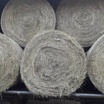
Fruktan- und zuckerarmes Heu in Premiumqualität !
Schollene
Guthof Mühlenfels
@Gutshof-Muehlenfels
Heu
Empfänger lädt ab
Rundballen
Bio
Regenfrei
3 weitere...
B+

Fruktan- und zuckerarmes Premium Wiesenheu !
Schollene
Guthof Mühlenfels
@Gutshof-Muehlenfels
Heu
Empfänger lädt ab
Rundballen
Regenfrei
3 weitere...
B+
Deprecated: Creation of dynamic property Zend_View_Helper_Ads::$adLink is deprecated in /var/www/stall-frei/htdocs/staging.stall-frei.de/library/Psf/View/Helper/Ads.php on line 108

Futtersack HeuToy, Fressbremse in pink
Mechtersen
STALL-FREIde Marketing
@STALL-FREI-Marketing
Stundenlange Beschäftigung die
Koliken vorbeugt, geringe Staubinhalation mit
steuerbarer Futterentnahme
Leider kein Vorschaubild
Leider kein Vorschaubild
Bio-Luzerneheu aus qualifiziertem Biobetrieb
Altmärkische Höhe OT Losse
Landwirtschaft H.Stoltenberg
@ReiterhofLosse
Heu
Empfänger lädt ab
Großballen
Bio
2 weitere...
B+
Leider kein Vorschaubild
Leider kein Vorschaubild
Biohafer zu verkaufen
Altmärkische Höhe OT Losse
Landwirtschaft H.Stoltenberg
@ReiterhofLosse
Futter
Empfänger lädt ab
Lose
Bio
Regenfrei
2 weitere...
B+


1 Palette Stramofarm Heupellets 30 Sack á 15Kg
Leinefelde
stramofarm GmbH
@stramofarm
Heu
Lieferant entlädt
Pellets
Regenfrei
2 weitere...
P+


1 Palette Stramofarm Strohpellets 30Sack á 25KG
Leinefelde- Worbis
stramofarm GmbH
@stramofarm
Einstreu
Lieferant entlädt
Pellets
Regenfrei
2 weitere...
P+
Leider kein Vorschaubild
Leider kein Vorschaubild
HD-Ballen Handballen Heu Heuballen Ernte 2024
Wolfsburg
Bendlin GbR
@Bendlin_GbR
Heu
Kleinballen/HD-Ballen
Regenfrei
Käufer lädt selbst
2 weitere...
B+
Leider kein Vorschaubild
Leider kein Vorschaubild
HD-Ballen Handballen Stroh Strohballen Ernte 2024
Wolfsburg
Bendlin GbR
@Bendlin_GbR
Stroh
Kleinballen/HD-Ballen
Regenfrei
Käufer lädt selbst
2 weitere...
B+

Heu und Heulage verkaufen
Mechtersen
STALL-FREIde Marketing
@STALL-FREI-Marketing
Verkaufen Sie Ihr Heu und Ihre Heulage direkt an Reiter, Pferdeställe und Reitanlagen
Heu Rundballen zu verkaufen
Peine
Hof-Hoppenworth
@Hof-Hoppenworth
Heu
Empfänger lädt ab
Rundballen
Regenfrei
3 weitere...
B+

Heupellets und Strohpellets Bio
Bogen
Marion Christ
@Marion-Christ
Einstreu
Pellets
Bio
Abholung
Lieferung
B+
Werde Teil von STALL-FREI.de
Verkaufe Heu, Heulage, Stroh, Einstreu oder Futter an Pferdehalter und Stallbetreiber
Deprecated: Creation of dynamic property Zend_View::$pageCount is deprecated in /var/www/stall-frei/htdocs/staging.stall-frei.de/library/vendor/shardj/zf1-future/library/Zend/View/Abstract.php on line 308
Deprecated: Creation of dynamic property Zend_View::$itemCountPerPage is deprecated in /var/www/stall-frei/htdocs/staging.stall-frei.de/library/vendor/shardj/zf1-future/library/Zend/View/Abstract.php on line 308
Deprecated: Creation of dynamic property Zend_View::$first is deprecated in /var/www/stall-frei/htdocs/staging.stall-frei.de/library/vendor/shardj/zf1-future/library/Zend/View/Abstract.php on line 308
Deprecated: Creation of dynamic property Zend_View::$current is deprecated in /var/www/stall-frei/htdocs/staging.stall-frei.de/library/vendor/shardj/zf1-future/library/Zend/View/Abstract.php on line 308
Deprecated: Creation of dynamic property Zend_View::$last is deprecated in /var/www/stall-frei/htdocs/staging.stall-frei.de/library/vendor/shardj/zf1-future/library/Zend/View/Abstract.php on line 308
Deprecated: Creation of dynamic property Zend_View::$previous is deprecated in /var/www/stall-frei/htdocs/staging.stall-frei.de/library/vendor/shardj/zf1-future/library/Zend/View/Abstract.php on line 308
Deprecated: Creation of dynamic property Zend_View::$next is deprecated in /var/www/stall-frei/htdocs/staging.stall-frei.de/library/vendor/shardj/zf1-future/library/Zend/View/Abstract.php on line 308
Deprecated: Creation of dynamic property Zend_View::$pagesInRange is deprecated in /var/www/stall-frei/htdocs/staging.stall-frei.de/library/vendor/shardj/zf1-future/library/Zend/View/Abstract.php on line 308
Deprecated: Creation of dynamic property Zend_View::$firstPageInRange is deprecated in /var/www/stall-frei/htdocs/staging.stall-frei.de/library/vendor/shardj/zf1-future/library/Zend/View/Abstract.php on line 308
Deprecated: Creation of dynamic property Zend_View::$lastPageInRange is deprecated in /var/www/stall-frei/htdocs/staging.stall-frei.de/library/vendor/shardj/zf1-future/library/Zend/View/Abstract.php on line 308
Deprecated: Creation of dynamic property Zend_View::$currentItemCount is deprecated in /var/www/stall-frei/htdocs/staging.stall-frei.de/library/vendor/shardj/zf1-future/library/Zend/View/Abstract.php on line 308
Deprecated: Creation of dynamic property Zend_View::$totalItemCount is deprecated in /var/www/stall-frei/htdocs/staging.stall-frei.de/library/vendor/shardj/zf1-future/library/Zend/View/Abstract.php on line 308
Deprecated: Creation of dynamic property Zend_View::$firstItemNumber is deprecated in /var/www/stall-frei/htdocs/staging.stall-frei.de/library/vendor/shardj/zf1-future/library/Zend/View/Abstract.php on line 308
Deprecated: Creation of dynamic property Zend_View::$lastItemNumber is deprecated in /var/www/stall-frei/htdocs/staging.stall-frei.de/library/vendor/shardj/zf1-future/library/Zend/View/Abstract.php on line 308
Deprecated: Creation of dynamic property Zend_View::$router is deprecated in /var/www/stall-frei/htdocs/staging.stall-frei.de/library/vendor/shardj/zf1-future/library/Zend/View/Abstract.php on line 308
Deprecated: Creation of dynamic property Zend_View::$urlParams is deprecated in /var/www/stall-frei/htdocs/staging.stall-frei.de/library/vendor/shardj/zf1-future/library/Zend/View/Abstract.php on line 308
Deprecated: Creation of dynamic property Zend_View::$showAds is deprecated in /var/www/stall-frei/htdocs/staging.stall-frei.de/library/vendor/shardj/zf1-future/library/Zend/View/Abstract.php on line 308
Deprecated: Creation of dynamic property Zend_View::$objectIds is deprecated in /var/www/stall-frei/htdocs/staging.stall-frei.de/library/vendor/shardj/zf1-future/library/Zend/View/Abstract.php on line 308
Deprecated: Creation of dynamic property Zend_View::$showNavbar is deprecated in /var/www/stall-frei/htdocs/staging.stall-frei.de/library/vendor/shardj/zf1-future/library/Zend/View/Abstract.php on line 308
Deprecated: Creation of dynamic property Zend_View::$showBreadcrumb is deprecated in /var/www/stall-frei/htdocs/staging.stall-frei.de/library/vendor/shardj/zf1-future/library/Zend/View/Abstract.php on line 308
Deprecated: Creation of dynamic property Zend_View::$showFooter is deprecated in /var/www/stall-frei/htdocs/staging.stall-frei.de/library/vendor/shardj/zf1-future/library/Zend/View/Abstract.php on line 308
Deprecated: Creation of dynamic property Zend_View::$showInternalAds is deprecated in /var/www/stall-frei/htdocs/staging.stall-frei.de/library/vendor/shardj/zf1-future/library/Zend/View/Abstract.php on line 308
Deprecated: Creation of dynamic property Zend_View::$blNoContent is deprecated in /var/www/stall-frei/htdocs/staging.stall-frei.de/library/vendor/shardj/zf1-future/library/Zend/View/Abstract.php on line 308
Deprecated: Creation of dynamic property Zend_View::$sMetaDesc is deprecated in /var/www/stall-frei/htdocs/staging.stall-frei.de/library/vendor/shardj/zf1-future/library/Zend/View/Abstract.php on line 308
Deprecated: Creation of dynamic property Zend_View::$useGmaps is deprecated in /var/www/stall-frei/htdocs/staging.stall-frei.de/library/vendor/shardj/zf1-future/library/Zend/View/Abstract.php on line 308
Deprecated: Creation of dynamic property Zend_View::$touches is deprecated in /var/www/stall-frei/htdocs/staging.stall-frei.de/library/vendor/shardj/zf1-future/library/Zend/View/Abstract.php on line 308
Deprecated: Creation of dynamic property Zend_View::$oProject is deprecated in /var/www/stall-frei/htdocs/staging.stall-frei.de/library/vendor/shardj/zf1-future/library/Zend/View/Abstract.php on line 308
Deprecated: Creation of dynamic property Zend_View::$pageHeadline is deprecated in /var/www/stall-frei/htdocs/staging.stall-frei.de/library/vendor/shardj/zf1-future/library/Zend/View/Abstract.php on line 308
Deprecated: Creation of dynamic property Zend_View::$disableLocationField is deprecated in /var/www/stall-frei/htdocs/staging.stall-frei.de/library/vendor/shardj/zf1-future/library/Zend/View/Abstract.php on line 308
Deprecated: Creation of dynamic property Zend_View::$isSearch is deprecated in /var/www/stall-frei/htdocs/staging.stall-frei.de/library/vendor/shardj/zf1-future/library/Zend/View/Abstract.php on line 308
Deprecated: Creation of dynamic property Zend_View::$pageTitle is deprecated in /var/www/stall-frei/htdocs/staging.stall-frei.de/library/vendor/shardj/zf1-future/library/Zend/View/Abstract.php on line 308
Deprecated: Creation of dynamic property Psf_Form_Element_Text::$class is deprecated in /var/www/stall-frei/htdocs/staging.stall-frei.de/library/vendor/shardj/zf1-future/library/Zend/Form/Element.php on line 874
Deprecated: Creation of dynamic property Psf_Form_Element_Text::$size is deprecated in /var/www/stall-frei/htdocs/staging.stall-frei.de/library/vendor/shardj/zf1-future/library/Zend/Form/Element.php on line 874
Deprecated: Creation of dynamic property Psf_Form_Element_Text::$placeholder is deprecated in /var/www/stall-frei/htdocs/staging.stall-frei.de/library/vendor/shardj/zf1-future/library/Zend/Form/Element.php on line 874
Deprecated: Creation of dynamic property Psf_Form_Element_Hidden::$class is deprecated in /var/www/stall-frei/htdocs/staging.stall-frei.de/library/vendor/shardj/zf1-future/library/Zend/Form/Element.php on line 874
Deprecated: Creation of dynamic property Psf_Form_Element_Hidden::$class is deprecated in /var/www/stall-frei/htdocs/staging.stall-frei.de/library/vendor/shardj/zf1-future/library/Zend/Form/Element.php on line 874
Deprecated: Creation of dynamic property Psf_Form_Element_Hidden::$class is deprecated in /var/www/stall-frei/htdocs/staging.stall-frei.de/library/vendor/shardj/zf1-future/library/Zend/Form/Element.php on line 874
Deprecated: Creation of dynamic property Psf_Form_Element_Hidden::$class is deprecated in /var/www/stall-frei/htdocs/staging.stall-frei.de/library/vendor/shardj/zf1-future/library/Zend/Form/Element.php on line 874
Deprecated: Creation of dynamic property Psf_Form_Element_Select::$class is deprecated in /var/www/stall-frei/htdocs/staging.stall-frei.de/library/vendor/shardj/zf1-future/library/Zend/Form/Element.php on line 874
Deprecated: Creation of dynamic property Psf_Form_Element_Select::$class is deprecated in /var/www/stall-frei/htdocs/staging.stall-frei.de/library/vendor/shardj/zf1-future/library/Zend/Form/Element.php on line 874
Deprecated: Creation of dynamic property Psf_Form_Element_Select::$class is deprecated in /var/www/stall-frei/htdocs/staging.stall-frei.de/library/vendor/shardj/zf1-future/library/Zend/Form/Element.php on line 874
Deprecated: Creation of dynamic property Psf_Form_Element_Select::$class is deprecated in /var/www/stall-frei/htdocs/staging.stall-frei.de/library/vendor/shardj/zf1-future/library/Zend/Form/Element.php on line 874
Deprecated: Creation of dynamic property Zend_View::$sort is deprecated in /var/www/stall-frei/htdocs/staging.stall-frei.de/library/vendor/shardj/zf1-future/library/Zend/View/Abstract.php on line 308
Deprecated: Creation of dynamic property Zend_View::$searchLocation is deprecated in /var/www/stall-frei/htdocs/staging.stall-frei.de/library/vendor/shardj/zf1-future/library/Zend/View/Abstract.php on line 308
Deprecated: Creation of dynamic property Zend_View::$locationHint is deprecated in /var/www/stall-frei/htdocs/staging.stall-frei.de/library/vendor/shardj/zf1-future/library/Zend/View/Abstract.php on line 308
Psf_GeoCoder_Abstract::getLocation: Oßling Get Location CachedOrLive
Psf_GeoCoder_Abstract::getCachedOrLive: Oßling
Psf_GeoCoder_Abstract::convertLocationResult
{"documentation":"https:\/\/opencagedata.com\/api","licenses":[{"name":"see attribution guide","url":"https:\/\/opencagedata.com\/credits"}],"results":[{"bounds":{"northeast":{"lat":51.3806507,"lng":14.2143555},"southwest":{"lat":51.3041827,"lng":14.0846658}},"components":{"ISO_3166-1_alpha-2":"DE","ISO_3166-1_alpha-3":"DEU","ISO_3166-2":["DE-SN"],"_category":"place","_normalized_city":"O\u00dfling","_type":"village","continent":"Europe","country":"Deutschland","country_code":"de","county":"Bautzen","political_union":"European Union","state":"Sachsen","state_code":"SN","village":"O\u00dfling"},"confidence":7,"formatted":"O\u00dfling, Sachsen, Deutschland","geometry":{"lat":51.3606986,"lng":14.1653238}},{"components":{"ISO_3166-1_alpha-2":"FR","ISO_3166-1_alpha-3":"FRA","ISO_3166-2":["FR-IDF","FR-92"],"_category":"road","_normalized_city":"Levallois-Perret","_type":"road","city":"Levallois-Perret","continent":"Europe","country":"France","country_code":"fr","county":"Hauts-de-Seine","local_authority":"M\u00e9tropole du Grand Paris","political_union":"European Union","postcode":"92300","road":"Rue Charles Deutschmann","state":"\u00cele-de-France","state_code":"IDF"},"confidence":2,"formatted":"Rue Charles Deutschmann, 92300 Levallois-Perret, France","geometry":{"lat":48.900049,"lng":2.2842}},{"components":{"ISO_3166-1_alpha-2":"FR","ISO_3166-1_alpha-3":"FRA","ISO_3166-2":["FR-CVL","FR-45"],"_category":"road","_normalized_city":"Le Moulinet-sur-Solin","_type":"road","city":"Le Moulinet-sur-Solin","continent":"Europe","country":"France","country_code":"fr","county":"Loiret","local_authority":"Communaut\u00e9 de communes Giennoises","political_union":"European Union","postcode":"45290","road":"Route de Langesse","state":"Centre-Val de Loire","state_code":"CVL"},"confidence":2,"formatted":"Route de Langesse, 45290 Le Moulinet-sur-Solin, France","geometry":{"lat":47.831156,"lng":2.63361}},{"components":{"ISO_3166-1_alpha-2":"FR","ISO_3166-1_alpha-3":"FRA","ISO_3166-2":["FR-CVL","FR-45"],"_category":"road","_normalized_city":"Le Moulinet-sur-Solin","_type":"road","city":"Le Moulinet-sur-Solin","continent":"Europe","country":"France","country_code":"fr","county":"Loiret","local_authority":"Communaut\u00e9 de communes Giennoises","political_union":"European Union","postcode":"45290","road":"Rue de Langesse","state":"Centre-Val de Loire","state_code":"CVL"},"confidence":2,"formatted":"Rue de Langesse, 45290 Le Moulinet-sur-Solin, France","geometry":{"lat":47.836523,"lng":2.628388}},{"components":{"ISO_3166-1_alpha-2":"FR","ISO_3166-1_alpha-3":"FRA","ISO_3166-2":["FR-CVL","FR-45"],"_category":"road","_normalized_city":"Villemandeur","_type":"road","city":"Villemandeur","continent":"Europe","country":"France","country_code":"fr","county":"Loiret","local_authority":"Communaut\u00e9 d'agglom\u00e9ration Montargoise et Rives du Loing","political_union":"European Union","postcode":"45700","road":"Rue du Solin","state":"Centre-Val de Loire","state_code":"CVL"},"confidence":2,"formatted":"Rue du Solin, 45700 Villemandeur, France","geometry":{"lat":47.993609,"lng":2.695438}},{"components":{"ISO_3166-1_alpha-2":"FR","ISO_3166-1_alpha-3":"FRA","ISO_3166-2":["FR-IDF","FR-77"],"_category":"road","_normalized_city":"Noyen-sur-Seine","_type":"road","city":"Noyen-sur-Seine","continent":"Europe","country":"France","country_code":"fr","county":"Seine-et-Marne","local_authority":"Communaut\u00e9 de communes Bass\u00e9e-Montois","political_union":"European Union","postcode":"77114","road":"Chemin de la Soline","state":"\u00cele-de-France","state_code":"IDF"},"confidence":2,"formatted":"Chemin de la Soline, 77114 Noyen-sur-Seine, France","geometry":{"lat":48.461643,"lng":3.341761}},{"components":{"ISO_3166-1_alpha-2":"FR","ISO_3166-1_alpha-3":"FRA","ISO_3166-2":["FR-CVL","FR-45"],"_category":"road","_normalized_city":"Villemandeur","_type":"road","city":"Villemandeur","continent":"Europe","country":"France","country_code":"fr","county":"Loiret","local_authority":"Communaut\u00e9 d'agglom\u00e9ration Montargoise et Rives du Loing","political_union":"European Union","postcode":"45700","road":"Aisance du Solin","state":"Centre-Val de Loire","state_code":"CVL"},"confidence":2,"formatted":"Aisance du Solin, 45700 Villemandeur, France","geometry":{"lat":47.994061,"lng":2.696275}},{"components":{"ISO_3166-1_alpha-2":"FR","ISO_3166-1_alpha-3":"FRA","ISO_3166-2":["FR-ARA","FR-38"],"_category":"road","_normalized_city":"Bellegarde-Poussieu","_type":"road","city":"Bellegarde-Poussieu","continent":"Europe","country":"France","country_code":"fr","county":"Is\u00e8re","local_authority":"Communaut\u00e9 de communes d'Entre Bi\u00e8vre et Rh\u00f4ne","political_union":"European Union","postcode":"38270","road":"Chemin Jean de Solin","state":"Auvergne-Rh\u00f4ne-Alpes","state_code":"ARA"},"confidence":2,"formatted":"Chemin Jean de Solin, 38270 Bellegarde-Poussieu, France","geometry":{"lat":45.396208,"lng":4.953083}},{"components":{"ISO_3166-1_alpha-2":"FR","ISO_3166-1_alpha-3":"FRA","ISO_3166-2":["FR-BFC","FR-71"],"_category":"road","_normalized_city":"Saint-Christophe-en-Brionnais","_type":"road","city":"Saint-Christophe-en-Brionnais","continent":"Europe","country":"France","country_code":"fr","county":"Sa\u00f4ne-et-Loire","local_authority":"Communaut\u00e9 de communes de Semur-en-Brionnais","political_union":"European Union","postcode":"71800","road":"Chemin de Solin","state":"Bourgogne-Franche-Comt\u00e9","state_code":"BFC"},"confidence":10,"formatted":"Chemin de Solin, 71800 Saint-Christophe-en-Brionnais, France","geometry":{"lat":46.279922,"lng":4.169566}},{"components":{"ISO_3166-1_alpha-2":"FR","ISO_3166-1_alpha-3":"FRA","ISO_3166-2":["FR-BFC","FR-71"],"_category":"road","_normalized_city":"Matour","_type":"road","city":"Matour","continent":"Europe","country":"France","country_code":"fr","county":"Sa\u00f4ne-et-Loire","local_authority":"Communaut\u00e9 de communes Saint-Cyr M\u00e8re Boitier entre Charolais et M\u00e2connais","political_union":"European Union","postcode":"71520","road":"Chemin des Solins","state":"Bourgogne-Franche-Comt\u00e9","state_code":"BFC"},"confidence":10,"formatted":"Chemin des Solins, 71520 Matour, France","geometry":{"lat":46.307535,"lng":4.449874}}],"status":{"code":200,"message":"OK"},"stay_informed":{"blog":"https:\/\/blog.opencagedata.com","mastodon":"https:\/\/en.osm.town\/@opencage"},"thanks":"For using an OpenCage API","timestamp":{"created_http":"Sun, 08 Feb 2026 06:45:03 GMT","created_unix":1770533103},"total_results":10}Array
(
[0] => stdClass Object
(
[bounds] => stdClass Object
(
[northeast] => stdClass Object
(
[lat] => 51.3806507
[lng] => 14.2143555
)
[southwest] => stdClass Object
(
[lat] => 51.3041827
[lng] => 14.0846658
)
)
[components] => stdClass Object
(
[ISO_3166-1_alpha-2] => DE
[ISO_3166-1_alpha-3] => DEU
[ISO_3166-2] => Array
(
[0] => DE-SN
)
[_category] => place
[_normalized_city] => Oßling
[_type] => village
[continent] => Europe
[country] => Deutschland
[country_code] => de
[county] => Bautzen
[political_union] => European Union
[state] => Sachsen
[state_code] => SN
[village] => Oßling
)
[confidence] => 7
[formatted] => Oßling, Sachsen, Deutschland
[geometry] => stdClass Object
(
[lat] => 51.3606986
[lng] => 14.1653238
)
)
[1] => stdClass Object
(
[components] => stdClass Object
(
[ISO_3166-1_alpha-2] => FR
[ISO_3166-1_alpha-3] => FRA
[ISO_3166-2] => Array
(
[0] => FR-IDF
[1] => FR-92
)
[_category] => road
[_normalized_city] => Levallois-Perret
[_type] => road
[city] => Levallois-Perret
[continent] => Europe
[country] => France
[country_code] => fr
[county] => Hauts-de-Seine
[local_authority] => Métropole du Grand Paris
[political_union] => European Union
[postcode] => 92300
[road] => Rue Charles Deutschmann
[state] => Île-de-France
[state_code] => IDF
)
[confidence] => 2
[formatted] => Rue Charles Deutschmann, 92300 Levallois-Perret, France
[geometry] => stdClass Object
(
[lat] => 48.900049
[lng] => 2.2842
)
)
[2] => stdClass Object
(
[components] => stdClass Object
(
[ISO_3166-1_alpha-2] => FR
[ISO_3166-1_alpha-3] => FRA
[ISO_3166-2] => Array
(
[0] => FR-CVL
[1] => FR-45
)
[_category] => road
[_normalized_city] => Le Moulinet-sur-Solin
[_type] => road
[city] => Le Moulinet-sur-Solin
[continent] => Europe
[country] => France
[country_code] => fr
[county] => Loiret
[local_authority] => Communauté de communes Giennoises
[political_union] => European Union
[postcode] => 45290
[road] => Route de Langesse
[state] => Centre-Val de Loire
[state_code] => CVL
)
[confidence] => 2
[formatted] => Route de Langesse, 45290 Le Moulinet-sur-Solin, France
[geometry] => stdClass Object
(
[lat] => 47.831156
[lng] => 2.63361
)
)
[3] => stdClass Object
(
[components] => stdClass Object
(
[ISO_3166-1_alpha-2] => FR
[ISO_3166-1_alpha-3] => FRA
[ISO_3166-2] => Array
(
[0] => FR-CVL
[1] => FR-45
)
[_category] => road
[_normalized_city] => Le Moulinet-sur-Solin
[_type] => road
[city] => Le Moulinet-sur-Solin
[continent] => Europe
[country] => France
[country_code] => fr
[county] => Loiret
[local_authority] => Communauté de communes Giennoises
[political_union] => European Union
[postcode] => 45290
[road] => Rue de Langesse
[state] => Centre-Val de Loire
[state_code] => CVL
)
[confidence] => 2
[formatted] => Rue de Langesse, 45290 Le Moulinet-sur-Solin, France
[geometry] => stdClass Object
(
[lat] => 47.836523
[lng] => 2.628388
)
)
[4] => stdClass Object
(
[components] => stdClass Object
(
[ISO_3166-1_alpha-2] => FR
[ISO_3166-1_alpha-3] => FRA
[ISO_3166-2] => Array
(
[0] => FR-CVL
[1] => FR-45
)
[_category] => road
[_normalized_city] => Villemandeur
[_type] => road
[city] => Villemandeur
[continent] => Europe
[country] => France
[country_code] => fr
[county] => Loiret
[local_authority] => Communauté d'agglomération Montargoise et Rives du Loing
[political_union] => European Union
[postcode] => 45700
[road] => Rue du Solin
[state] => Centre-Val de Loire
[state_code] => CVL
)
[confidence] => 2
[formatted] => Rue du Solin, 45700 Villemandeur, France
[geometry] => stdClass Object
(
[lat] => 47.993609
[lng] => 2.695438
)
)
[5] => stdClass Object
(
[components] => stdClass Object
(
[ISO_3166-1_alpha-2] => FR
[ISO_3166-1_alpha-3] => FRA
[ISO_3166-2] => Array
(
[0] => FR-IDF
[1] => FR-77
)
[_category] => road
[_normalized_city] => Noyen-sur-Seine
[_type] => road
[city] => Noyen-sur-Seine
[continent] => Europe
[country] => France
[country_code] => fr
[county] => Seine-et-Marne
[local_authority] => Communauté de communes Bassée-Montois
[political_union] => European Union
[postcode] => 77114
[road] => Chemin de la Soline
[state] => Île-de-France
[state_code] => IDF
)
[confidence] => 2
[formatted] => Chemin de la Soline, 77114 Noyen-sur-Seine, France
[geometry] => stdClass Object
(
[lat] => 48.461643
[lng] => 3.341761
)
)
[6] => stdClass Object
(
[components] => stdClass Object
(
[ISO_3166-1_alpha-2] => FR
[ISO_3166-1_alpha-3] => FRA
[ISO_3166-2] => Array
(
[0] => FR-CVL
[1] => FR-45
)
[_category] => road
[_normalized_city] => Villemandeur
[_type] => road
[city] => Villemandeur
[continent] => Europe
[country] => France
[country_code] => fr
[county] => Loiret
[local_authority] => Communauté d'agglomération Montargoise et Rives du Loing
[political_union] => European Union
[postcode] => 45700
[road] => Aisance du Solin
[state] => Centre-Val de Loire
[state_code] => CVL
)
[confidence] => 2
[formatted] => Aisance du Solin, 45700 Villemandeur, France
[geometry] => stdClass Object
(
[lat] => 47.994061
[lng] => 2.696275
)
)
[7] => stdClass Object
(
[components] => stdClass Object
(
[ISO_3166-1_alpha-2] => FR
[ISO_3166-1_alpha-3] => FRA
[ISO_3166-2] => Array
(
[0] => FR-ARA
[1] => FR-38
)
[_category] => road
[_normalized_city] => Bellegarde-Poussieu
[_type] => road
[city] => Bellegarde-Poussieu
[continent] => Europe
[country] => France
[country_code] => fr
[county] => Isère
[local_authority] => Communauté de communes d'Entre Bièvre et Rhône
[political_union] => European Union
[postcode] => 38270
[road] => Chemin Jean de Solin
[state] => Auvergne-Rhône-Alpes
[state_code] => ARA
)
[confidence] => 2
[formatted] => Chemin Jean de Solin, 38270 Bellegarde-Poussieu, France
[geometry] => stdClass Object
(
[lat] => 45.396208
[lng] => 4.953083
)
)
[8] => stdClass Object
(
[components] => stdClass Object
(
[ISO_3166-1_alpha-2] => FR
[ISO_3166-1_alpha-3] => FRA
[ISO_3166-2] => Array
(
[0] => FR-BFC
[1] => FR-71
)
[_category] => road
[_normalized_city] => Saint-Christophe-en-Brionnais
[_type] => road
[city] => Saint-Christophe-en-Brionnais
[continent] => Europe
[country] => France
[country_code] => fr
[county] => Saône-et-Loire
[local_authority] => Communauté de communes de Semur-en-Brionnais
[political_union] => European Union
[postcode] => 71800
[road] => Chemin de Solin
[state] => Bourgogne-Franche-Comté
[state_code] => BFC
)
[confidence] => 10
[formatted] => Chemin de Solin, 71800 Saint-Christophe-en-Brionnais, France
[geometry] => stdClass Object
(
[lat] => 46.279922
[lng] => 4.169566
)
)
[9] => stdClass Object
(
[components] => stdClass Object
(
[ISO_3166-1_alpha-2] => FR
[ISO_3166-1_alpha-3] => FRA
[ISO_3166-2] => Array
(
[0] => FR-BFC
[1] => FR-71
)
[_category] => road
[_normalized_city] => Matour
[_type] => road
[city] => Matour
[continent] => Europe
[country] => France
[country_code] => fr
[county] => Saône-et-Loire
[local_authority] => Communauté de communes Saint-Cyr Mère Boitier entre Charolais et Mâconnais
[political_union] => European Union
[postcode] => 71520
[road] => Chemin des Solins
[state] => Bourgogne-Franche-Comté
[state_code] => BFC
)
[confidence] => 10
[formatted] => Chemin des Solins, 71520 Matour, France
[geometry] => stdClass Object
(
[lat] => 46.307535
[lng] => 4.449874
)
)
)
Psf_GeoCoder_OpenCageData::getKeyMap: 0
stdClass Object
(
    [bounds] => stdClass Object
        (
            [northeast] => stdClass Object
                (
                    [lat] => 51.3806507
                    [lng] => 14.2143555
                )

            [southwest] => stdClass Object
                (
                    [lat] => 51.3041827
                    [lng] => 14.0846658
                )

        )

    [components] => stdClass Object
        (
            [ISO_3166-1_alpha-2] => DE
            [ISO_3166-1_alpha-3] => DEU
            [ISO_3166-2] => Array
                (
                    [0] => DE-SN
                )

            [_category] => place
            [_normalized_city] => Oßling
            [_type] => village
            [continent] => Europe
            [country] => Deutschland
            [country_code] => de
            [county] => Bautzen
            [political_union] => European Union
            [state] => Sachsen
            [state_code] => SN
            [village] => Oßling
        )

    [confidence] => 7
    [formatted] => Oßling, Sachsen, Deutschland
    [geometry] => stdClass Object
        (
            [lat] => 51.3606986
            [lng] => 14.1653238
        )

)
Psf_GeoCoder_OpenCageData::getCounty: Bautzen
Psf_GeoCoder_OpenCageData::addMissingData REFETCH!
Array
(
    [address] => Oßling, Sachsen, Deutschland
    [type] => village
    [street] =>
    [city] => Oßling
    [county] => Bautzen
    [state] => Sachsen
    [zip] =>
    [country] => Deutschland
    [suburb] =>
    [countrycode] => de
    [latitude] => 51.3606986
    [longitude] => 14.1653238
    [accuracy] => 1
    [confidence] => 7
    [bounds] => stdClass Object
        (
            [northeast] => stdClass Object
                (
                    [lat] => 51.3806507
                    [lng] => 14.2143555
                )

            [southwest] => stdClass Object
                (
                    [lat] => 51.3041827
                    [lng] => 14.0846658
                )

        )

)
reformat!
Array
(
    [address] => Oßling, Sachsen, Deutschland
    [type] => village
    [street] =>
    [city] => Oßling
    [county] => Bautzen
    [state] => Sachsen
    [zip] =>
    [country] => Deutschland
    [suburb] =>
    [countrycode] => de
    [latitude] => 51.3606986
    [longitude] => 14.1653238
    [accuracy] => 1
    [confidence] => 7
    [bounds] => stdClass Object
        (
            [northeast] => stdClass Object
                (
                    [lat] => 51.3806507
                    [lng] => 14.2143555
                )

            [southwest] => stdClass Object
                (
                    [lat] => 51.3041827
                    [lng] => 14.0846658
                )

        )

    [place] => Oßling, Sachsen
    [hash] => 6ba9413d8458bef4aa7084ffc3ad998a
)
Psf_GeoCoder_OpenCageData::getKeyMap: 1
stdClass Object
(
    [components] => stdClass Object
        (
            [ISO_3166-1_alpha-2] => FR
            [ISO_3166-1_alpha-3] => FRA
            [ISO_3166-2] => Array
                (
                    [0] => FR-IDF
                    [1] => FR-92
                )

            [_category] => road
            [_normalized_city] => Levallois-Perret
            [_type] => road
            [city] => Levallois-Perret
            [continent] => Europe
            [country] => France
            [country_code] => fr
            [county] => Hauts-de-Seine
            [local_authority] => Métropole du Grand Paris
            [political_union] => European Union
            [postcode] => 92300
            [road] => Rue Charles Deutschmann
            [state] => Île-de-France
            [state_code] => IDF
        )

    [confidence] => 2
    [formatted] => Rue Charles Deutschmann, 92300 Levallois-Perret, France
    [geometry] => stdClass Object
        (
            [lat] => 48.900049
            [lng] => 2.2842
        )

)
Psf_GeoCoder_OpenCageData::getCounty: Hauts-de-Seine
Psf_GeoCoder_OpenCageData::addMissingData REFETCH!
Array
(
    [address] => Rue Charles Deutschmann, 92300 Levallois-Perret, France
    [type] => road
    [street] => Rue Charles Deutschmann
    [city] => Levallois-Perret
    [county] => Hauts-de-Seine
    [state] => Île-de-France
    [zip] => 92300
    [country] => France
    [suburb] =>
    [countrycode] => fr
    [latitude] => 48.900049
    [longitude] => 2.2842
    [accuracy] => 1
    [confidence] => 2
    [bounds] =>
)
reformat!
Array
(
    [address] => Rue Charles Deutschmann, 92300 Levallois-Perret, France
    [type] => road
    [street] => Rue Charles Deutschmann
    [city] => Levallois-Perret
    [county] => Hauts-de-Seine
    [state] => Île-de-France
    [zip] => 92300
    [country] => France
    [suburb] =>
    [countrycode] => fr
    [latitude] => 48.900049
    [longitude] => 2.2842
    [accuracy] => 1
    [confidence] => 2
    [bounds] =>
    [place] => Rue Charles Deutschmann, 92300 Levallois-Perret, Île-de-France
    [hash] => b7dc44def3990e8a7eaf18e019eca466
)
Psf_GeoCoder_OpenCageData::getKeyMap: 2
stdClass Object
(
    [components] => stdClass Object
        (
            [ISO_3166-1_alpha-2] => FR
            [ISO_3166-1_alpha-3] => FRA
            [ISO_3166-2] => Array
                (
                    [0] => FR-CVL
                    [1] => FR-45
                )

            [_category] => road
            [_normalized_city] => Le Moulinet-sur-Solin
            [_type] => road
            [city] => Le Moulinet-sur-Solin
            [continent] => Europe
            [country] => France
            [country_code] => fr
            [county] => Loiret
            [local_authority] => Communauté de communes Giennoises
            [political_union] => European Union
            [postcode] => 45290
            [road] => Route de Langesse
            [state] => Centre-Val de Loire
            [state_code] => CVL
        )

    [confidence] => 2
    [formatted] => Route de Langesse, 45290 Le Moulinet-sur-Solin, France
    [geometry] => stdClass Object
        (
            [lat] => 47.831156
            [lng] => 2.63361
        )

)
Psf_GeoCoder_OpenCageData::getCounty: Loiret
Psf_GeoCoder_OpenCageData::addMissingData REFETCH!
Array
(
    [address] => Route de Langesse, 45290 Le Moulinet-sur-Solin, France
    [type] => road
    [street] => Route de Langesse
    [city] => Le Moulinet-sur-Solin
    [county] => Loiret
    [state] => Centre-Val de Loire
    [zip] => 45290
    [country] => France
    [suburb] =>
    [countrycode] => fr
    [latitude] => 47.831156
    [longitude] => 2.63361
    [accuracy] => 1
    [confidence] => 2
    [bounds] =>
)
reformat!
Array
(
    [address] => Route de Langesse, 45290 Le Moulinet-sur-Solin, France
    [type] => road
    [street] => Route de Langesse
    [city] => Le Moulinet-sur-Solin
    [county] => Loiret
    [state] => Centre-Val de Loire
    [zip] => 45290
    [country] => France
    [suburb] =>
    [countrycode] => fr
    [latitude] => 47.831156
    [longitude] => 2.63361
    [accuracy] => 1
    [confidence] => 2
    [bounds] =>
    [place] => Route de Langesse, 45290 Le Moulinet-sur-Solin, Centre-Val de Loire
    [hash] => 42c7090b0270b829444a40b72bca9603
)
Psf_GeoCoder_OpenCageData::getKeyMap: 3
stdClass Object
(
    [components] => stdClass Object
        (
            [ISO_3166-1_alpha-2] => FR
            [ISO_3166-1_alpha-3] => FRA
            [ISO_3166-2] => Array
                (
                    [0] => FR-CVL
                    [1] => FR-45
                )

            [_category] => road
            [_normalized_city] => Le Moulinet-sur-Solin
            [_type] => road
            [city] => Le Moulinet-sur-Solin
            [continent] => Europe
            [country] => France
            [country_code] => fr
            [county] => Loiret
            [local_authority] => Communauté de communes Giennoises
            [political_union] => European Union
            [postcode] => 45290
            [road] => Rue de Langesse
            [state] => Centre-Val de Loire
            [state_code] => CVL
        )

    [confidence] => 2
    [formatted] => Rue de Langesse, 45290 Le Moulinet-sur-Solin, France
    [geometry] => stdClass Object
        (
            [lat] => 47.836523
            [lng] => 2.628388
        )

)
Psf_GeoCoder_OpenCageData::getCounty: Loiret
Psf_GeoCoder_OpenCageData::addMissingData REFETCH!
Array
(
    [address] => Rue de Langesse, 45290 Le Moulinet-sur-Solin, France
    [type] => road
    [street] => Rue de Langesse
    [city] => Le Moulinet-sur-Solin
    [county] => Loiret
    [state] => Centre-Val de Loire
    [zip] => 45290
    [country] => France
    [suburb] =>
    [countrycode] => fr
    [latitude] => 47.836523
    [longitude] => 2.628388
    [accuracy] => 1
    [confidence] => 2
    [bounds] =>
)
reformat!
Array
(
    [address] => Rue de Langesse, 45290 Le Moulinet-sur-Solin, France
    [type] => road
    [street] => Rue de Langesse
    [city] => Le Moulinet-sur-Solin
    [county] => Loiret
    [state] => Centre-Val de Loire
    [zip] => 45290
    [country] => France
    [suburb] =>
    [countrycode] => fr
    [latitude] => 47.836523
    [longitude] => 2.628388
    [accuracy] => 1
    [confidence] => 2
    [bounds] =>
    [place] => Rue de Langesse, 45290 Le Moulinet-sur-Solin, Centre-Val de Loire
    [hash] => e12e2508a314f6ed3cac0b9f49c1a152
)
Psf_GeoCoder_OpenCageData::getKeyMap: 4
stdClass Object
(
    [components] => stdClass Object
        (
            [ISO_3166-1_alpha-2] => FR
            [ISO_3166-1_alpha-3] => FRA
            [ISO_3166-2] => Array
                (
                    [0] => FR-CVL
                    [1] => FR-45
                )

            [_category] => road
            [_normalized_city] => Villemandeur
            [_type] => road
            [city] => Villemandeur
            [continent] => Europe
            [country] => France
            [country_code] => fr
            [county] => Loiret
            [local_authority] => Communauté d'agglomération Montargoise et Rives du Loing
            [political_union] => European Union
            [postcode] => 45700
            [road] => Rue du Solin
            [state] => Centre-Val de Loire
            [state_code] => CVL
        )

    [confidence] => 2
    [formatted] => Rue du Solin, 45700 Villemandeur, France
    [geometry] => stdClass Object
        (
            [lat] => 47.993609
            [lng] => 2.695438
        )

)
Psf_GeoCoder_OpenCageData::getCounty: Loiret
Psf_GeoCoder_OpenCageData::addMissingData REFETCH!
Array
(
    [address] => Rue du Solin, 45700 Villemandeur, France
    [type] => road
    [street] => Rue du Solin
    [city] => Villemandeur
    [county] => Loiret
    [state] => Centre-Val de Loire
    [zip] => 45700
    [country] => France
    [suburb] =>
    [countrycode] => fr
    [latitude] => 47.993609
    [longitude] => 2.695438
    [accuracy] => 1
    [confidence] => 2
    [bounds] =>
)
reformat!
Array
(
    [address] => Rue du Solin, 45700 Villemandeur, France
    [type] => road
    [street] => Rue du Solin
    [city] => Villemandeur
    [county] => Loiret
    [state] => Centre-Val de Loire
    [zip] => 45700
    [country] => France
    [suburb] =>
    [countrycode] => fr
    [latitude] => 47.993609
    [longitude] => 2.695438
    [accuracy] => 1
    [confidence] => 2
    [bounds] =>
    [place] => Rue du Solin, 45700 Villemandeur, Centre-Val de Loire
    [hash] => e37cb4baeabf5ecb61cd0c977040aa5a
)
Psf_GeoCoder_OpenCageData::getKeyMap: 5
stdClass Object
(
    [components] => stdClass Object
        (
            [ISO_3166-1_alpha-2] => FR
            [ISO_3166-1_alpha-3] => FRA
            [ISO_3166-2] => Array
                (
                    [0] => FR-IDF
                    [1] => FR-77
                )

            [_category] => road
            [_normalized_city] => Noyen-sur-Seine
            [_type] => road
            [city] => Noyen-sur-Seine
            [continent] => Europe
            [country] => France
            [country_code] => fr
            [county] => Seine-et-Marne
            [local_authority] => Communauté de communes Bassée-Montois
            [political_union] => European Union
            [postcode] => 77114
            [road] => Chemin de la Soline
            [state] => Île-de-France
            [state_code] => IDF
        )

    [confidence] => 2
    [formatted] => Chemin de la Soline, 77114 Noyen-sur-Seine, France
    [geometry] => stdClass Object
        (
            [lat] => 48.461643
            [lng] => 3.341761
        )

)
Psf_GeoCoder_OpenCageData::getCounty: Seine-et-Marne
Psf_GeoCoder_OpenCageData::addMissingData REFETCH!
Array
(
    [address] => Chemin de la Soline, 77114 Noyen-sur-Seine, France
    [type] => road
    [street] => Chemin de la Soline
    [city] => Noyen-sur-Seine
    [county] => Seine-et-Marne
    [state] => Île-de-France
    [zip] => 77114
    [country] => France
    [suburb] =>
    [countrycode] => fr
    [latitude] => 48.461643
    [longitude] => 3.341761
    [accuracy] => 1
    [confidence] => 2
    [bounds] =>
)
reformat!
Array
(
    [address] => Chemin de la Soline, 77114 Noyen-sur-Seine, France
    [type] => road
    [street] => Chemin de la Soline
    [city] => Noyen-sur-Seine
    [county] => Seine-et-Marne
    [state] => Île-de-France
    [zip] => 77114
    [country] => France
    [suburb] =>
    [countrycode] => fr
    [latitude] => 48.461643
    [longitude] => 3.341761
    [accuracy] => 1
    [confidence] => 2
    [bounds] =>
    [place] => Chemin de la Soline, 77114 Noyen-sur-Seine, Île-de-France
    [hash] => 57a224d6e26195ddfdff0618f104017b
)
Psf_GeoCoder_OpenCageData::getKeyMap: 6
stdClass Object
(
    [components] => stdClass Object
        (
            [ISO_3166-1_alpha-2] => FR
            [ISO_3166-1_alpha-3] => FRA
            [ISO_3166-2] => Array
                (
                    [0] => FR-CVL
                    [1] => FR-45
                )

            [_category] => road
            [_normalized_city] => Villemandeur
            [_type] => road
            [city] => Villemandeur
            [continent] => Europe
            [country] => France
            [country_code] => fr
            [county] => Loiret
            [local_authority] => Communauté d'agglomération Montargoise et Rives du Loing
            [political_union] => European Union
            [postcode] => 45700
            [road] => Aisance du Solin
            [state] => Centre-Val de Loire
            [state_code] => CVL
        )

    [confidence] => 2
    [formatted] => Aisance du Solin, 45700 Villemandeur, France
    [geometry] => stdClass Object
        (
            [lat] => 47.994061
            [lng] => 2.696275
        )

)
Psf_GeoCoder_OpenCageData::getCounty: Loiret
Psf_GeoCoder_OpenCageData::addMissingData REFETCH!
Array
(
    [address] => Aisance du Solin, 45700 Villemandeur, France
    [type] => road
    [street] => Aisance du Solin
    [city] => Villemandeur
    [county] => Loiret
    [state] => Centre-Val de Loire
    [zip] => 45700
    [country] => France
    [suburb] =>
    [countrycode] => fr
    [latitude] => 47.994061
    [longitude] => 2.696275
    [accuracy] => 1
    [confidence] => 2
    [bounds] =>
)
reformat!
Array
(
    [address] => Aisance du Solin, 45700 Villemandeur, France
    [type] => road
    [street] => Aisance du Solin
    [city] => Villemandeur
    [county] => Loiret
    [state] => Centre-Val de Loire
    [zip] => 45700
    [country] => France
    [suburb] =>
    [countrycode] => fr
    [latitude] => 47.994061
    [longitude] => 2.696275
    [accuracy] => 1
    [confidence] => 2
    [bounds] =>
    [place] => Aisance du Solin, 45700 Villemandeur, Centre-Val de Loire
    [hash] => 5f87ec3f143eb73f7ddd18434981dfdc
)
Psf_GeoCoder_OpenCageData::getKeyMap: 7
stdClass Object
(
    [components] => stdClass Object
        (
            [ISO_3166-1_alpha-2] => FR
            [ISO_3166-1_alpha-3] => FRA
            [ISO_3166-2] => Array
                (
                    [0] => FR-ARA
                    [1] => FR-38
                )

            [_category] => road
            [_normalized_city] => Bellegarde-Poussieu
            [_type] => road
            [city] => Bellegarde-Poussieu
            [continent] => Europe
            [country] => France
            [country_code] => fr
            [county] => Isère
            [local_authority] => Communauté de communes d'Entre Bièvre et Rhône
            [political_union] => European Union
            [postcode] => 38270
            [road] => Chemin Jean de Solin
            [state] => Auvergne-Rhône-Alpes
            [state_code] => ARA
        )

    [confidence] => 2
    [formatted] => Chemin Jean de Solin, 38270 Bellegarde-Poussieu, France
    [geometry] => stdClass Object
        (
            [lat] => 45.396208
            [lng] => 4.953083
        )

)
Psf_GeoCoder_OpenCageData::getCounty: Isère
Psf_GeoCoder_OpenCageData::addMissingData REFETCH!
Array
(
    [address] => Chemin Jean de Solin, 38270 Bellegarde-Poussieu, France
    [type] => road
    [street] => Chemin Jean de Solin
    [city] => Bellegarde-Poussieu
    [county] => Isère
    [state] => Auvergne-Rhône-Alpes
    [zip] => 38270
    [country] => France
    [suburb] =>
    [countrycode] => fr
    [latitude] => 45.396208
    [longitude] => 4.953083
    [accuracy] => 1
    [confidence] => 2
    [bounds] =>
)
reformat!
Array
(
    [address] => Chemin Jean de Solin, 38270 Bellegarde-Poussieu, France
    [type] => road
    [street] => Chemin Jean de Solin
    [city] => Bellegarde-Poussieu
    [county] => Isère
    [state] => Auvergne-Rhône-Alpes
    [zip] => 38270
    [country] => France
    [suburb] =>
    [countrycode] => fr
    [latitude] => 45.396208
    [longitude] => 4.953083
    [accuracy] => 1
    [confidence] => 2
    [bounds] =>
    [place] => Chemin Jean de Solin, 38270 Bellegarde-Poussieu, Auvergne-Rhône-Alpes
    [hash] => 261807deb4a9cd872579904bf78e29e9
)
Psf_GeoCoder_OpenCageData::getKeyMap: 8
stdClass Object
(
    [components] => stdClass Object
        (
            [ISO_3166-1_alpha-2] => FR
            [ISO_3166-1_alpha-3] => FRA
            [ISO_3166-2] => Array
                (
                    [0] => FR-BFC
                    [1] => FR-71
                )

            [_category] => road
            [_normalized_city] => Saint-Christophe-en-Brionnais
            [_type] => road
            [city] => Saint-Christophe-en-Brionnais
            [continent] => Europe
            [country] => France
            [country_code] => fr
            [county] => Saône-et-Loire
            [local_authority] => Communauté de communes de Semur-en-Brionnais
            [political_union] => European Union
            [postcode] => 71800
            [road] => Chemin de Solin
            [state] => Bourgogne-Franche-Comté
            [state_code] => BFC
        )

    [confidence] => 10
    [formatted] => Chemin de Solin, 71800 Saint-Christophe-en-Brionnais, France
    [geometry] => stdClass Object
        (
            [lat] => 46.279922
            [lng] => 4.169566
        )

)
Psf_GeoCoder_OpenCageData::getCounty: Saône-et-Loire
Psf_GeoCoder_OpenCageData::addMissingData REFETCH!
Array
(
    [address] => Chemin de Solin, 71800 Saint-Christophe-en-Brionnais, France
    [type] => road
    [street] => Chemin de Solin
    [city] => Saint-Christophe-en-Brionnais
    [county] => Saône-et-Loire
    [state] => Bourgogne-Franche-Comté
    [zip] => 71800
    [country] => France
    [suburb] =>
    [countrycode] => fr
    [latitude] => 46.279922
    [longitude] => 4.169566
    [accuracy] => 1
    [confidence] => 10
    [bounds] =>
)
reformat!
Array
(
    [address] => Chemin de Solin, 71800 Saint-Christophe-en-Brionnais, France
    [type] => road
    [street] => Chemin de Solin
    [city] => Saint-Christophe-en-Brionnais
    [county] => Saône-et-Loire
    [state] => Bourgogne-Franche-Comté
    [zip] => 71800
    [country] => France
    [suburb] =>
    [countrycode] => fr
    [latitude] => 46.279922
    [longitude] => 4.169566
    [accuracy] => 1
    [confidence] => 10
    [bounds] =>
    [place] => Chemin de Solin, 71800 Saint-Christophe-en-Brionnais, Bourgogne-Franche-Comté
    [hash] => badb683cade21e72cd9caf9037a144ff
)
Psf_GeoCoder_OpenCageData::getKeyMap: 9
stdClass Object
(
    [components] => stdClass Object
        (
            [ISO_3166-1_alpha-2] => FR
            [ISO_3166-1_alpha-3] => FRA
            [ISO_3166-2] => Array
                (
                    [0] => FR-BFC
                    [1] => FR-71
                )

            [_category] => road
            [_normalized_city] => Matour
            [_type] => road
            [city] => Matour
            [continent] => Europe
            [country] => France
            [country_code] => fr
            [county] => Saône-et-Loire
            [local_authority] => Communauté de communes Saint-Cyr Mère Boitier entre Charolais et Mâconnais
            [political_union] => European Union
            [postcode] => 71520
            [road] => Chemin des Solins
            [state] => Bourgogne-Franche-Comté
            [state_code] => BFC
        )

    [confidence] => 10
    [formatted] => Chemin des Solins, 71520 Matour, France
    [geometry] => stdClass Object
        (
            [lat] => 46.307535
            [lng] => 4.449874
        )

)
Psf_GeoCoder_OpenCageData::getCounty: Saône-et-Loire
Psf_GeoCoder_OpenCageData::addMissingData REFETCH!
Array
(
    [address] => Chemin des Solins, 71520 Matour, France
    [type] => road
    [street] => Chemin des Solins
    [city] => Matour
    [county] => Saône-et-Loire
    [state] => Bourgogne-Franche-Comté
    [zip] => 71520
    [country] => France
    [suburb] =>
    [countrycode] => fr
    [latitude] => 46.307535
    [longitude] => 4.449874
    [accuracy] => 1
    [confidence] => 10
    [bounds] =>
)
reformat!
Array
(
    [address] => Chemin des Solins, 71520 Matour, France
    [type] => road
    [street] => Chemin des Solins
    [city] => Matour
    [county] => Saône-et-Loire
    [state] => Bourgogne-Franche-Comté
    [zip] => 71520
    [country] => France
    [suburb] =>
    [countrycode] => fr
    [latitude] => 46.307535
    [longitude] => 4.449874
    [accuracy] => 1
    [confidence] => 10
    [bounds] =>
    [place] => Chemin des Solins, 71520 Matour, Bourgogne-Franche-Comté
    [hash] => 5c1c0c40aa8181af05aa5dc69daaef37
)
Deprecated: Creation of dynamic property Zend_View::$locationHintStyle is deprecated in /var/www/stall-frei/htdocs/staging.stall-frei.de/library/vendor/shardj/zf1-future/library/Zend/View/Abstract.php on line 308
Deprecated: Creation of dynamic property Zend_View::$adGeoLocation is deprecated in /var/www/stall-frei/htdocs/staging.stall-frei.de/library/vendor/shardj/zf1-future/library/Zend/View/Abstract.php on line 308
Deprecated: Creation of dynamic property Zend_View::$recordCount is deprecated in /var/www/stall-frei/htdocs/staging.stall-frei.de/library/vendor/shardj/zf1-future/library/Zend/View/Abstract.php on line 308
Deprecated: Creation of dynamic property Zend_View::$paginationParams is deprecated in /var/www/stall-frei/htdocs/staging.stall-frei.de/library/vendor/shardj/zf1-future/library/Zend/View/Abstract.php on line 308
Deprecated: Creation of dynamic property Zend_View::$objectPaginator is deprecated in /var/www/stall-frei/htdocs/staging.stall-frei.de/library/vendor/shardj/zf1-future/library/Zend/View/Abstract.php on line 308
Deprecated: Creation of dynamic property Zend_View::$featuredObjects is deprecated in /var/www/stall-frei/htdocs/staging.stall-frei.de/library/vendor/shardj/zf1-future/library/Zend/View/Abstract.php on line 308
Deprecated: Creation of dynamic property Zend_View::$hints is deprecated in /var/www/stall-frei/htdocs/staging.stall-frei.de/library/vendor/shardj/zf1-future/library/Zend/View/Abstract.php on line 308
Deprecated: Creation of dynamic property Zend_View::$attributeHints is deprecated in /var/www/stall-frei/htdocs/staging.stall-frei.de/library/vendor/shardj/zf1-future/library/Zend/View/Abstract.php on line 308
Deprecated: Creation of dynamic property Zend_View::$oSearchForm is deprecated in /var/www/stall-frei/htdocs/staging.stall-frei.de/library/vendor/shardj/zf1-future/library/Zend/View/Abstract.php on line 308