Deprecated: Creation of dynamic property Zend_View::$sMode is deprecated in /var/www/stall-frei/htdocs/staging.stall-frei.de/library/vendor/shardj/zf1-future/library/Zend/View/Abstract.php on line 308
Heu, Stroh oder Futter in Willersdorf
Gesucht wird in "Willersdorf, Hessen, Deutschland"
95 Einträge
Deprecated: Creation of dynamic property Zend_View::$listObjects is deprecated in /var/www/stall-frei/htdocs/staging.stall-frei.de/library/vendor/shardj/zf1-future/library/Zend/View/Abstract.php on line 308
Deprecated: Creation of dynamic property Zend_View::$listMode is deprecated in /var/www/stall-frei/htdocs/staging.stall-frei.de/library/vendor/shardj/zf1-future/library/Zend/View/Abstract.php on line 308
Deprecated: Creation of dynamic property Zend_View::$renderedObjects is deprecated in /var/www/stall-frei/htdocs/staging.stall-frei.de/library/vendor/shardj/zf1-future/library/Zend/View/Abstract.php on line 308
Deprecated: Creation of dynamic property Zend_View::$index is deprecated in /var/www/stall-frei/htdocs/staging.stall-frei.de/library/vendor/shardj/zf1-future/library/Zend/View/Abstract.php on line 308
Deprecated: Creation of dynamic property Zend_View::$displayMode is deprecated in /var/www/stall-frei/htdocs/staging.stall-frei.de/library/vendor/shardj/zf1-future/library/Zend/View/Abstract.php on line 308
Deprecated: Creation of dynamic property Zend_View::$remarketingIds is deprecated in /var/www/stall-frei/htdocs/staging.stall-frei.de/library/vendor/shardj/zf1-future/library/Zend/View/Abstract.php on line 308
Deprecated: Creation of dynamic property Zend_View::$listItem is deprecated in /var/www/stall-frei/htdocs/staging.stall-frei.de/library/vendor/shardj/zf1-future/library/Zend/View/Abstract.php on line 308
Deprecated: Creation of dynamic property Zend_View::$object is deprecated in /var/www/stall-frei/htdocs/staging.stall-frei.de/library/vendor/shardj/zf1-future/library/Zend/View/Abstract.php on line 308
Deprecated: Creation of dynamic property Zend_View::$attributes is deprecated in /var/www/stall-frei/htdocs/staging.stall-frei.de/library/vendor/shardj/zf1-future/library/Zend/View/Abstract.php on line 308

Leinenstroh
schermbeck
VLS Agrar GmbH
@VLS-Agrar
Einstreu
Empfänger lädt ab
Kleinballen/HD-Ballen
Lieferung
P+
Deprecated: Creation of dynamic property Zend_View_Helper_Ads::$adLink is deprecated in /var/www/stall-frei/htdocs/staging.stall-frei.de/library/Psf/View/Helper/Ads.php on line 108

Frisches Stroh zu verkaufen!
Mechtersen
STALL-FREIde Marketing
@STALL-FREI-Marketing
Kaufe frisches Stroh für dein Pferd!


P+

B+

B+

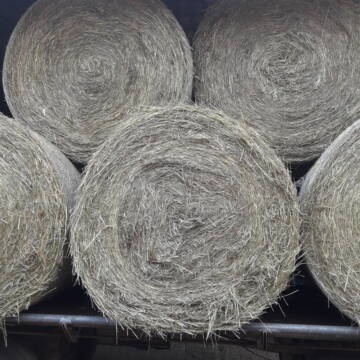
Rundballen Heu Bioheu Pferdeheu
Krefeld
Petra
@Petra7
Heu
Empfänger lädt ab
Rundballen
Bio
Regenfrei
2 weitere...
B+
Leider kein Vorschaubild
Leider kein Vorschaubild
Heu - HD Ballen aus Juni 2025
Wunstorf
Heike-Wichmann-Sasse
@Heike-Wichmann-Sasse
Heu
Empfänger lädt ab
Kleinballen/HD-Ballen
Regenfrei
2 weitere...
B+

Leider kein Vorschaubild
Leider kein Vorschaubild
Pferdeheu in Rundballen zu verkaufen
Velen
Klaus-Weigelt
@Klaus-Weigelt
Heu
Lieferant entlädt
Rundballen
Regenfrei
3 weitere...
B+

Bestes Heu in Großballen zu verkaufen
Voerde (Niederrhein)
Ute Sprock
@utesprock
Heu
Empfänger lädt ab
Rundballen
Regenfrei
3 weitere...
B+
Heu Rundballen zu verkaufen
Peine
Hof-Hoppenworth
@Hof-Hoppenworth
Heu
Empfänger lädt ab
Rundballen
Regenfrei
3 weitere...
B+

HD-Ballen Heu
Ginsweiler
Laura
@Heuverkauf_Ginsweiler
Heu
Kleinballen/HD-Ballen
Regenfrei
Wird verladen
2 weitere...
B+
Veröffentliche deine Suche als Gesuch und Suchauftrag, dann erhältst du Angebote, neue Treffer und Änderungen per E-Mail.
Diese Suche als Gesuch veröffentlichenDeprecated: Creation of dynamic property Zend_View::$pageCount is deprecated in /var/www/stall-frei/htdocs/staging.stall-frei.de/library/vendor/shardj/zf1-future/library/Zend/View/Abstract.php on line 308
Deprecated: Creation of dynamic property Zend_View::$itemCountPerPage is deprecated in /var/www/stall-frei/htdocs/staging.stall-frei.de/library/vendor/shardj/zf1-future/library/Zend/View/Abstract.php on line 308
Deprecated: Creation of dynamic property Zend_View::$first is deprecated in /var/www/stall-frei/htdocs/staging.stall-frei.de/library/vendor/shardj/zf1-future/library/Zend/View/Abstract.php on line 308
Deprecated: Creation of dynamic property Zend_View::$current is deprecated in /var/www/stall-frei/htdocs/staging.stall-frei.de/library/vendor/shardj/zf1-future/library/Zend/View/Abstract.php on line 308
Deprecated: Creation of dynamic property Zend_View::$last is deprecated in /var/www/stall-frei/htdocs/staging.stall-frei.de/library/vendor/shardj/zf1-future/library/Zend/View/Abstract.php on line 308
Deprecated: Creation of dynamic property Zend_View::$previous is deprecated in /var/www/stall-frei/htdocs/staging.stall-frei.de/library/vendor/shardj/zf1-future/library/Zend/View/Abstract.php on line 308
Deprecated: Creation of dynamic property Zend_View::$next is deprecated in /var/www/stall-frei/htdocs/staging.stall-frei.de/library/vendor/shardj/zf1-future/library/Zend/View/Abstract.php on line 308
Deprecated: Creation of dynamic property Zend_View::$pagesInRange is deprecated in /var/www/stall-frei/htdocs/staging.stall-frei.de/library/vendor/shardj/zf1-future/library/Zend/View/Abstract.php on line 308
Deprecated: Creation of dynamic property Zend_View::$firstPageInRange is deprecated in /var/www/stall-frei/htdocs/staging.stall-frei.de/library/vendor/shardj/zf1-future/library/Zend/View/Abstract.php on line 308
Deprecated: Creation of dynamic property Zend_View::$lastPageInRange is deprecated in /var/www/stall-frei/htdocs/staging.stall-frei.de/library/vendor/shardj/zf1-future/library/Zend/View/Abstract.php on line 308
Deprecated: Creation of dynamic property Zend_View::$currentItemCount is deprecated in /var/www/stall-frei/htdocs/staging.stall-frei.de/library/vendor/shardj/zf1-future/library/Zend/View/Abstract.php on line 308
Deprecated: Creation of dynamic property Zend_View::$totalItemCount is deprecated in /var/www/stall-frei/htdocs/staging.stall-frei.de/library/vendor/shardj/zf1-future/library/Zend/View/Abstract.php on line 308
Deprecated: Creation of dynamic property Zend_View::$firstItemNumber is deprecated in /var/www/stall-frei/htdocs/staging.stall-frei.de/library/vendor/shardj/zf1-future/library/Zend/View/Abstract.php on line 308
Deprecated: Creation of dynamic property Zend_View::$lastItemNumber is deprecated in /var/www/stall-frei/htdocs/staging.stall-frei.de/library/vendor/shardj/zf1-future/library/Zend/View/Abstract.php on line 308
Deprecated: Creation of dynamic property Zend_View::$router is deprecated in /var/www/stall-frei/htdocs/staging.stall-frei.de/library/vendor/shardj/zf1-future/library/Zend/View/Abstract.php on line 308
Deprecated: Creation of dynamic property Zend_View::$urlParams is deprecated in /var/www/stall-frei/htdocs/staging.stall-frei.de/library/vendor/shardj/zf1-future/library/Zend/View/Abstract.php on line 308
Deprecated: Creation of dynamic property Zend_View::$showAds is deprecated in /var/www/stall-frei/htdocs/staging.stall-frei.de/library/vendor/shardj/zf1-future/library/Zend/View/Abstract.php on line 308
Deprecated: Creation of dynamic property Zend_View::$objectIds is deprecated in /var/www/stall-frei/htdocs/staging.stall-frei.de/library/vendor/shardj/zf1-future/library/Zend/View/Abstract.php on line 308
Deprecated: Creation of dynamic property Zend_View::$showNavbar is deprecated in /var/www/stall-frei/htdocs/staging.stall-frei.de/library/vendor/shardj/zf1-future/library/Zend/View/Abstract.php on line 308
Deprecated: Creation of dynamic property Zend_View::$showBreadcrumb is deprecated in /var/www/stall-frei/htdocs/staging.stall-frei.de/library/vendor/shardj/zf1-future/library/Zend/View/Abstract.php on line 308
Deprecated: Creation of dynamic property Zend_View::$showFooter is deprecated in /var/www/stall-frei/htdocs/staging.stall-frei.de/library/vendor/shardj/zf1-future/library/Zend/View/Abstract.php on line 308
Deprecated: Creation of dynamic property Zend_View::$showInternalAds is deprecated in /var/www/stall-frei/htdocs/staging.stall-frei.de/library/vendor/shardj/zf1-future/library/Zend/View/Abstract.php on line 308
Deprecated: Creation of dynamic property Zend_View::$blNoContent is deprecated in /var/www/stall-frei/htdocs/staging.stall-frei.de/library/vendor/shardj/zf1-future/library/Zend/View/Abstract.php on line 308
Deprecated: Creation of dynamic property Zend_View::$sMetaDesc is deprecated in /var/www/stall-frei/htdocs/staging.stall-frei.de/library/vendor/shardj/zf1-future/library/Zend/View/Abstract.php on line 308
Deprecated: Creation of dynamic property Zend_View::$useGmaps is deprecated in /var/www/stall-frei/htdocs/staging.stall-frei.de/library/vendor/shardj/zf1-future/library/Zend/View/Abstract.php on line 308
Deprecated: Creation of dynamic property Zend_View::$touches is deprecated in /var/www/stall-frei/htdocs/staging.stall-frei.de/library/vendor/shardj/zf1-future/library/Zend/View/Abstract.php on line 308
Deprecated: Creation of dynamic property Zend_View::$oProject is deprecated in /var/www/stall-frei/htdocs/staging.stall-frei.de/library/vendor/shardj/zf1-future/library/Zend/View/Abstract.php on line 308
Deprecated: Creation of dynamic property Zend_View::$pageHeadline is deprecated in /var/www/stall-frei/htdocs/staging.stall-frei.de/library/vendor/shardj/zf1-future/library/Zend/View/Abstract.php on line 308
Deprecated: Creation of dynamic property Zend_View::$disableLocationField is deprecated in /var/www/stall-frei/htdocs/staging.stall-frei.de/library/vendor/shardj/zf1-future/library/Zend/View/Abstract.php on line 308
Deprecated: Creation of dynamic property Zend_View::$isSearch is deprecated in /var/www/stall-frei/htdocs/staging.stall-frei.de/library/vendor/shardj/zf1-future/library/Zend/View/Abstract.php on line 308
Deprecated: Creation of dynamic property Zend_View::$pageTitle is deprecated in /var/www/stall-frei/htdocs/staging.stall-frei.de/library/vendor/shardj/zf1-future/library/Zend/View/Abstract.php on line 308
Deprecated: Creation of dynamic property Psf_Form_Element_Text::$class is deprecated in /var/www/stall-frei/htdocs/staging.stall-frei.de/library/vendor/shardj/zf1-future/library/Zend/Form/Element.php on line 874
Deprecated: Creation of dynamic property Psf_Form_Element_Text::$size is deprecated in /var/www/stall-frei/htdocs/staging.stall-frei.de/library/vendor/shardj/zf1-future/library/Zend/Form/Element.php on line 874
Deprecated: Creation of dynamic property Psf_Form_Element_Text::$placeholder is deprecated in /var/www/stall-frei/htdocs/staging.stall-frei.de/library/vendor/shardj/zf1-future/library/Zend/Form/Element.php on line 874
Deprecated: Creation of dynamic property Psf_Form_Element_Hidden::$class is deprecated in /var/www/stall-frei/htdocs/staging.stall-frei.de/library/vendor/shardj/zf1-future/library/Zend/Form/Element.php on line 874
Deprecated: Creation of dynamic property Psf_Form_Element_Hidden::$class is deprecated in /var/www/stall-frei/htdocs/staging.stall-frei.de/library/vendor/shardj/zf1-future/library/Zend/Form/Element.php on line 874
Deprecated: Creation of dynamic property Psf_Form_Element_Hidden::$class is deprecated in /var/www/stall-frei/htdocs/staging.stall-frei.de/library/vendor/shardj/zf1-future/library/Zend/Form/Element.php on line 874
Deprecated: Creation of dynamic property Psf_Form_Element_Hidden::$class is deprecated in /var/www/stall-frei/htdocs/staging.stall-frei.de/library/vendor/shardj/zf1-future/library/Zend/Form/Element.php on line 874
Deprecated: Creation of dynamic property Psf_Form_Element_Select::$class is deprecated in /var/www/stall-frei/htdocs/staging.stall-frei.de/library/vendor/shardj/zf1-future/library/Zend/Form/Element.php on line 874
Deprecated: Creation of dynamic property Psf_Form_Element_Select::$class is deprecated in /var/www/stall-frei/htdocs/staging.stall-frei.de/library/vendor/shardj/zf1-future/library/Zend/Form/Element.php on line 874
Deprecated: Creation of dynamic property Psf_Form_Element_Select::$class is deprecated in /var/www/stall-frei/htdocs/staging.stall-frei.de/library/vendor/shardj/zf1-future/library/Zend/Form/Element.php on line 874
Deprecated: Creation of dynamic property Psf_Form_Element_Select::$class is deprecated in /var/www/stall-frei/htdocs/staging.stall-frei.de/library/vendor/shardj/zf1-future/library/Zend/Form/Element.php on line 874
Deprecated: Creation of dynamic property Zend_View::$sort is deprecated in /var/www/stall-frei/htdocs/staging.stall-frei.de/library/vendor/shardj/zf1-future/library/Zend/View/Abstract.php on line 308
Deprecated: Creation of dynamic property Zend_View::$searchLocation is deprecated in /var/www/stall-frei/htdocs/staging.stall-frei.de/library/vendor/shardj/zf1-future/library/Zend/View/Abstract.php on line 308
Deprecated: Creation of dynamic property Zend_View::$locationHint is deprecated in /var/www/stall-frei/htdocs/staging.stall-frei.de/library/vendor/shardj/zf1-future/library/Zend/View/Abstract.php on line 308
Psf_GeoCoder_Abstract::getLocation: Willersdorf Get Location CachedOrLive
Psf_GeoCoder_Abstract::getCachedOrLive: Willersdorf
Psf_GeoCoder_Abstract::convertLocationResult
{"documentation":"https:\/\/opencagedata.com\/api","licenses":[{"name":"see attribution guide","url":"https:\/\/opencagedata.com\/credits"}],"results":[{"bounds":{"northeast":{"lat":51.0396044,"lng":8.8752848},"southwest":{"lat":51.0181949,"lng":8.8305004}},"components":{"ISO_3166-1_alpha-2":"DE","ISO_3166-1_alpha-3":"DEU","ISO_3166-2":["DE-HE"],"_category":"place","_normalized_city":"Willersdorf","_type":"village","continent":"Europe","country":"Deutschland","country_code":"de","county":"Landkreis Waldeck-Frankenberg","municipality":"Frankenberg (Eder)","political_union":"European Union","state":"Hessen","state_code":"HE","village":"Willersdorf"},"confidence":7,"formatted":"Willersdorf, Hessen, Deutschland","geometry":{"lat":51.0267179,"lng":8.8506157}},{"bounds":{"northeast":{"lat":49.7626046,"lng":10.9830586},"southwest":{"lat":49.7226046,"lng":10.9430586}},"components":{"ISO_3166-1_alpha-2":"DE","ISO_3166-1_alpha-3":"DEU","ISO_3166-2":["DE-BY"],"_category":"place","_normalized_city":"Hallerndorf","_type":"village","city":"Hallerndorf","continent":"Europe","country":"Deutschland","country_code":"de","county":"Landkreis Forchheim","political_union":"European Union","postcode":"91352","state":"Bayern","state_code":"BY","village":"Willersdorf"},"confidence":7,"formatted":"91352 Willersdorf, Deutschland","geometry":{"lat":49.7426046,"lng":10.9630586}},{"bounds":{"northeast":{"lat":50.4851662,"lng":11.917901},"southwest":{"lat":50.4597296,"lng":11.8686534}},"components":{"ISO_3166-1_alpha-2":"DE","ISO_3166-1_alpha-3":"DEU","ISO_3166-2":["DE-TH"],"_category":"place","_normalized_city":"Willersdorf","_type":"village","city_district":"Rothenacker","continent":"Europe","country":"Deutschland","country_code":"de","county":"Saale-Orla-Kreis","municipality":"Tanna","political_union":"European Union","state":"Th\u00fcringen","state_code":"TH","village":"Willersdorf"},"confidence":7,"formatted":"Rothenacker, Willersdorf, Th\u00fcringen, Deutschland","geometry":{"lat":50.4779295,"lng":11.8973347}},{"bounds":{"northeast":{"lat":48.7460491,"lng":11.9331211},"southwest":{"lat":48.7060491,"lng":11.8931211}},"components":{"ISO_3166-1_alpha-2":"DE","ISO_3166-1_alpha-3":"DEU","ISO_3166-2":["DE-BY"],"_category":"place","_normalized_city":"Wildenberg","_type":"village","city":"Wildenberg","continent":"Europe","country":"Deutschland","country_code":"de","county":"Landkreis Kelheim","municipality":"Siegenburg (VGem)","political_union":"European Union","postcode":"93359","state":"Bayern","state_code":"BY","village":"Willersdorf"},"confidence":7,"formatted":"93359 Willersdorf, Deutschland","geometry":{"lat":48.7260491,"lng":11.9131211}},{"bounds":{"northeast":{"lat":48.5551399,"lng":11.9520198},"southwest":{"lat":48.5151399,"lng":11.9120198}},"components":{"ISO_3166-1_alpha-2":"DE","ISO_3166-1_alpha-3":"DEU","ISO_3166-2":["DE-BY"],"_category":"place","_normalized_city":"Gammelsdorf","_type":"hamlet","city":"Gammelsdorf","continent":"Europe","country":"Deutschland","country_code":"de","county":"Landkreis Freising","hamlet":"Willersdorf","municipality":"Mauern (VGem)","political_union":"European Union","postcode":"85408","state":"Bayern","state_code":"BY"},"confidence":7,"formatted":"Willersdorf, 85408 Gammelsdorf, Deutschland","geometry":{"lat":48.5351399,"lng":11.9320198}},{"bounds":{"northeast":{"lat":48.5708223,"lng":13.6982382},"southwest":{"lat":48.5308223,"lng":13.6582382}},"components":{"ISO_3166-1_alpha-2":"DE","ISO_3166-1_alpha-3":"DEU","ISO_3166-2":["DE-BY"],"_category":"place","_normalized_city":"Untergriesbach","_type":"hamlet","city":"Untergriesbach","continent":"Europe","country":"Deutschland","country_code":"de","county":"Landkreis Passau","hamlet":"Willersdorf","political_union":"European Union","postcode":"94107","state":"Bayern","state_code":"BY"},"confidence":7,"formatted":"Willersdorf, 94107 Untergriesbach, Deutschland","geometry":{"lat":48.5508223,"lng":13.6782382}},{"bounds":{"northeast":{"lat":50.4789673,"lng":11.9011531},"southwest":{"lat":50.4760032,"lng":11.8945184}},"components":{"ISO_3166-1_alpha-2":"DE","ISO_3166-1_alpha-3":"DEU","ISO_3166-2":["DE-TH"],"_category":"road","_normalized_city":"Tanna","_type":"road","city_district":"Rothenacker","continent":"Europe","country":"Deutschland","country_code":"de","county":"Saale-Orla-Kreis","municipality":"Tanna","political_union":"European Union","postcode":"07922","road":"Willersdorf","road_type":"tertiary","state":"Th\u00fcringen","state_code":"TH","town":"Tanna","village":"Willersdorf"},"confidence":9,"formatted":"Willersdorf, 07922 Willersdorf, Deutschland","geometry":{"lat":50.4779555,"lng":11.8979792}},{"bounds":{"northeast":{"lat":48.535306,"lng":11.9314045},"southwest":{"lat":48.5346723,"lng":11.9291889}},"components":{"ISO_3166-1_alpha-2":"DE","ISO_3166-1_alpha-3":"DEU","ISO_3166-2":["DE-BY"],"_category":"road","_normalized_city":"Gammelsdorf","_type":"road","city":"Gammelsdorf","continent":"Europe","country":"Deutschland","country_code":"de","county":"Landkreis Freising","hamlet":"Willersdorf","municipality":"Mauern (VGem)","political_union":"European Union","postcode":"85408","road":"Willersdorf","state":"Bayern","state_code":"BY"},"confidence":9,"formatted":"Willersdorf, 85408 Gammelsdorf, Deutschland","geometry":{"lat":48.5349094,"lng":11.9303238}},{"bounds":{"northeast":{"lat":49.7399178,"lng":10.9618306},"southwest":{"lat":49.7395214,"lng":10.9617034}},"components":{"ISO_3166-1_alpha-2":"DE","ISO_3166-1_alpha-3":"DEU","ISO_3166-2":["DE-BY"],"_category":"road","_normalized_city":"Hallerndorf","_type":"road","city":"Hallerndorf","continent":"Europe","country":"Deutschland","country_code":"de","county":"Landkreis Forchheim","political_union":"European Union","postcode":"91352","road":"Willersdorf","road_type":"tertiary","state":"Bayern","state_code":"BY","village":"Willersdorf"},"confidence":9,"formatted":"Willersdorf, 91352 Willersdorf, Deutschland","geometry":{"lat":49.7397183,"lng":10.9617616}},{"components":{"ISO_3166-1_alpha-2":"FR","ISO_3166-1_alpha-3":"FRA","ISO_3166-2":["FR-GES","FR-6AE","FR-68"],"_category":"road","_normalized_city":"Walheim","_type":"road","city":"Walheim","continent":"Europe","country":"France","country_code":"fr","county":"Haut-Rhin","local_authority":"Communaut\u00e9 de communes Sundgau","political_union":"European Union","postcode":"68130","road":"Rue de Wittersdorf","state":"Grand Est","state_code":"GES"},"confidence":3,"formatted":"Rue de Wittersdorf, 68130 Walheim, France","geometry":{"lat":47.639186,"lng":7.270277}}],"status":{"code":200,"message":"OK"},"stay_informed":{"blog":"https:\/\/blog.opencagedata.com","mastodon":"https:\/\/en.osm.town\/@opencage"},"thanks":"For using an OpenCage API","timestamp":{"created_http":"Sun, 08 Feb 2026 22:10:34 GMT","created_unix":1770588634},"total_results":10}Array
(
[0] => stdClass Object
(
[bounds] => stdClass Object
(
[northeast] => stdClass Object
(
[lat] => 51.0396044
[lng] => 8.8752848
)
[southwest] => stdClass Object
(
[lat] => 51.0181949
[lng] => 8.8305004
)
)
[components] => stdClass Object
(
[ISO_3166-1_alpha-2] => DE
[ISO_3166-1_alpha-3] => DEU
[ISO_3166-2] => Array
(
[0] => DE-HE
)
[_category] => place
[_normalized_city] => Willersdorf
[_type] => village
[continent] => Europe
[country] => Deutschland
[country_code] => de
[county] => Landkreis Waldeck-Frankenberg
[municipality] => Frankenberg (Eder)
[political_union] => European Union
[state] => Hessen
[state_code] => HE
[village] => Willersdorf
)
[confidence] => 7
[formatted] => Willersdorf, Hessen, Deutschland
[geometry] => stdClass Object
(
[lat] => 51.0267179
[lng] => 8.8506157
)
)
[1] => stdClass Object
(
[bounds] => stdClass Object
(
[northeast] => stdClass Object
(
[lat] => 49.7626046
[lng] => 10.9830586
)
[southwest] => stdClass Object
(
[lat] => 49.7226046
[lng] => 10.9430586
)
)
[components] => stdClass Object
(
[ISO_3166-1_alpha-2] => DE
[ISO_3166-1_alpha-3] => DEU
[ISO_3166-2] => Array
(
[0] => DE-BY
)
[_category] => place
[_normalized_city] => Hallerndorf
[_type] => village
[city] => Hallerndorf
[continent] => Europe
[country] => Deutschland
[country_code] => de
[county] => Landkreis Forchheim
[political_union] => European Union
[postcode] => 91352
[state] => Bayern
[state_code] => BY
[village] => Willersdorf
)
[confidence] => 7
[formatted] => 91352 Willersdorf, Deutschland
[geometry] => stdClass Object
(
[lat] => 49.7426046
[lng] => 10.9630586
)
)
[2] => stdClass Object
(
[bounds] => stdClass Object
(
[northeast] => stdClass Object
(
[lat] => 50.4851662
[lng] => 11.917901
)
[southwest] => stdClass Object
(
[lat] => 50.4597296
[lng] => 11.8686534
)
)
[components] => stdClass Object
(
[ISO_3166-1_alpha-2] => DE
[ISO_3166-1_alpha-3] => DEU
[ISO_3166-2] => Array
(
[0] => DE-TH
)
[_category] => place
[_normalized_city] => Willersdorf
[_type] => village
[city_district] => Rothenacker
[continent] => Europe
[country] => Deutschland
[country_code] => de
[county] => Saale-Orla-Kreis
[municipality] => Tanna
[political_union] => European Union
[state] => Thüringen
[state_code] => TH
[village] => Willersdorf
)
[confidence] => 7
[formatted] => Rothenacker, Willersdorf, Thüringen, Deutschland
[geometry] => stdClass Object
(
[lat] => 50.4779295
[lng] => 11.8973347
)
)
[3] => stdClass Object
(
[bounds] => stdClass Object
(
[northeast] => stdClass Object
(
[lat] => 48.7460491
[lng] => 11.9331211
)
[southwest] => stdClass Object
(
[lat] => 48.7060491
[lng] => 11.8931211
)
)
[components] => stdClass Object
(
[ISO_3166-1_alpha-2] => DE
[ISO_3166-1_alpha-3] => DEU
[ISO_3166-2] => Array
(
[0] => DE-BY
)
[_category] => place
[_normalized_city] => Wildenberg
[_type] => village
[city] => Wildenberg
[continent] => Europe
[country] => Deutschland
[country_code] => de
[county] => Landkreis Kelheim
[municipality] => Siegenburg (VGem)
[political_union] => European Union
[postcode] => 93359
[state] => Bayern
[state_code] => BY
[village] => Willersdorf
)
[confidence] => 7
[formatted] => 93359 Willersdorf, Deutschland
[geometry] => stdClass Object
(
[lat] => 48.7260491
[lng] => 11.9131211
)
)
[4] => stdClass Object
(
[bounds] => stdClass Object
(
[northeast] => stdClass Object
(
[lat] => 48.5551399
[lng] => 11.9520198
)
[southwest] => stdClass Object
(
[lat] => 48.5151399
[lng] => 11.9120198
)
)
[components] => stdClass Object
(
[ISO_3166-1_alpha-2] => DE
[ISO_3166-1_alpha-3] => DEU
[ISO_3166-2] => Array
(
[0] => DE-BY
)
[_category] => place
[_normalized_city] => Gammelsdorf
[_type] => hamlet
[city] => Gammelsdorf
[continent] => Europe
[country] => Deutschland
[country_code] => de
[county] => Landkreis Freising
[hamlet] => Willersdorf
[municipality] => Mauern (VGem)
[political_union] => European Union
[postcode] => 85408
[state] => Bayern
[state_code] => BY
)
[confidence] => 7
[formatted] => Willersdorf, 85408 Gammelsdorf, Deutschland
[geometry] => stdClass Object
(
[lat] => 48.5351399
[lng] => 11.9320198
)
)
[5] => stdClass Object
(
[bounds] => stdClass Object
(
[northeast] => stdClass Object
(
[lat] => 48.5708223
[lng] => 13.6982382
)
[southwest] => stdClass Object
(
[lat] => 48.5308223
[lng] => 13.6582382
)
)
[components] => stdClass Object
(
[ISO_3166-1_alpha-2] => DE
[ISO_3166-1_alpha-3] => DEU
[ISO_3166-2] => Array
(
[0] => DE-BY
)
[_category] => place
[_normalized_city] => Untergriesbach
[_type] => hamlet
[city] => Untergriesbach
[continent] => Europe
[country] => Deutschland
[country_code] => de
[county] => Landkreis Passau
[hamlet] => Willersdorf
[political_union] => European Union
[postcode] => 94107
[state] => Bayern
[state_code] => BY
)
[confidence] => 7
[formatted] => Willersdorf, 94107 Untergriesbach, Deutschland
[geometry] => stdClass Object
(
[lat] => 48.5508223
[lng] => 13.6782382
)
)
[6] => stdClass Object
(
[bounds] => stdClass Object
(
[northeast] => stdClass Object
(
[lat] => 50.4789673
[lng] => 11.9011531
)
[southwest] => stdClass Object
(
[lat] => 50.4760032
[lng] => 11.8945184
)
)
[components] => stdClass Object
(
[ISO_3166-1_alpha-2] => DE
[ISO_3166-1_alpha-3] => DEU
[ISO_3166-2] => Array
(
[0] => DE-TH
)
[_category] => road
[_normalized_city] => Tanna
[_type] => road
[city_district] => Rothenacker
[continent] => Europe
[country] => Deutschland
[country_code] => de
[county] => Saale-Orla-Kreis
[municipality] => Tanna
[political_union] => European Union
[postcode] => 07922
[road] => Willersdorf
[road_type] => tertiary
[state] => Thüringen
[state_code] => TH
[town] => Tanna
[village] => Willersdorf
)
[confidence] => 9
[formatted] => Willersdorf, 07922 Willersdorf, Deutschland
[geometry] => stdClass Object
(
[lat] => 50.4779555
[lng] => 11.8979792
)
)
[7] => stdClass Object
(
[bounds] => stdClass Object
(
[northeast] => stdClass Object
(
[lat] => 48.535306
[lng] => 11.9314045
)
[southwest] => stdClass Object
(
[lat] => 48.5346723
[lng] => 11.9291889
)
)
[components] => stdClass Object
(
[ISO_3166-1_alpha-2] => DE
[ISO_3166-1_alpha-3] => DEU
[ISO_3166-2] => Array
(
[0] => DE-BY
)
[_category] => road
[_normalized_city] => Gammelsdorf
[_type] => road
[city] => Gammelsdorf
[continent] => Europe
[country] => Deutschland
[country_code] => de
[county] => Landkreis Freising
[hamlet] => Willersdorf
[municipality] => Mauern (VGem)
[political_union] => European Union
[postcode] => 85408
[road] => Willersdorf
[state] => Bayern
[state_code] => BY
)
[confidence] => 9
[formatted] => Willersdorf, 85408 Gammelsdorf, Deutschland
[geometry] => stdClass Object
(
[lat] => 48.5349094
[lng] => 11.9303238
)
)
[8] => stdClass Object
(
[bounds] => stdClass Object
(
[northeast] => stdClass Object
(
[lat] => 49.7399178
[lng] => 10.9618306
)
[southwest] => stdClass Object
(
[lat] => 49.7395214
[lng] => 10.9617034
)
)
[components] => stdClass Object
(
[ISO_3166-1_alpha-2] => DE
[ISO_3166-1_alpha-3] => DEU
[ISO_3166-2] => Array
(
[0] => DE-BY
)
[_category] => road
[_normalized_city] => Hallerndorf
[_type] => road
[city] => Hallerndorf
[continent] => Europe
[country] => Deutschland
[country_code] => de
[county] => Landkreis Forchheim
[political_union] => European Union
[postcode] => 91352
[road] => Willersdorf
[road_type] => tertiary
[state] => Bayern
[state_code] => BY
[village] => Willersdorf
)
[confidence] => 9
[formatted] => Willersdorf, 91352 Willersdorf, Deutschland
[geometry] => stdClass Object
(
[lat] => 49.7397183
[lng] => 10.9617616
)
)
[9] => stdClass Object
(
[components] => stdClass Object
(
[ISO_3166-1_alpha-2] => FR
[ISO_3166-1_alpha-3] => FRA
[ISO_3166-2] => Array
(
[0] => FR-GES
[1] => FR-6AE
[2] => FR-68
)
[_category] => road
[_normalized_city] => Walheim
[_type] => road
[city] => Walheim
[continent] => Europe
[country] => France
[country_code] => fr
[county] => Haut-Rhin
[local_authority] => Communauté de communes Sundgau
[political_union] => European Union
[postcode] => 68130
[road] => Rue de Wittersdorf
[state] => Grand Est
[state_code] => GES
)
[confidence] => 3
[formatted] => Rue de Wittersdorf, 68130 Walheim, France
[geometry] => stdClass Object
(
[lat] => 47.639186
[lng] => 7.270277
)
)
)
Psf_GeoCoder_OpenCageData::getKeyMap: 0
stdClass Object
(
    [bounds] => stdClass Object
        (
            [northeast] => stdClass Object
                (
                    [lat] => 51.0396044
                    [lng] => 8.8752848
                )

            [southwest] => stdClass Object
                (
                    [lat] => 51.0181949
                    [lng] => 8.8305004
                )

        )

    [components] => stdClass Object
        (
            [ISO_3166-1_alpha-2] => DE
            [ISO_3166-1_alpha-3] => DEU
            [ISO_3166-2] => Array
                (
                    [0] => DE-HE
                )

            [_category] => place
            [_normalized_city] => Willersdorf
            [_type] => village
            [continent] => Europe
            [country] => Deutschland
            [country_code] => de
            [county] => Landkreis Waldeck-Frankenberg
            [municipality] => Frankenberg (Eder)
            [political_union] => European Union
            [state] => Hessen
            [state_code] => HE
            [village] => Willersdorf
        )

    [confidence] => 7
    [formatted] => Willersdorf, Hessen, Deutschland
    [geometry] => stdClass Object
        (
            [lat] => 51.0267179
            [lng] => 8.8506157
        )

)
Psf_GeoCoder_OpenCageData::getCounty: Waldeck-Frankenberg
Psf_GeoCoder_OpenCageData::addMissingData REFETCH!
Array
(
    [address] => Willersdorf, Hessen, Deutschland
    [type] => village
    [street] =>
    [city] => Willersdorf
    [county] => Waldeck-Frankenberg
    [state] => Hessen
    [zip] =>
    [country] => Deutschland
    [suburb] =>
    [countrycode] => de
    [latitude] => 51.0267179
    [longitude] => 8.8506157
    [accuracy] => 1
    [confidence] => 7
    [bounds] => stdClass Object
        (
            [northeast] => stdClass Object
                (
                    [lat] => 51.0396044
                    [lng] => 8.8752848
                )

            [southwest] => stdClass Object
                (
                    [lat] => 51.0181949
                    [lng] => 8.8305004
                )

        )

)
reformat!
Array
(
    [address] => Willersdorf, Hessen, Deutschland
    [type] => village
    [street] =>
    [city] => Willersdorf
    [county] => Waldeck-Frankenberg
    [state] => Hessen
    [zip] =>
    [country] => Deutschland
    [suburb] =>
    [countrycode] => de
    [latitude] => 51.0267179
    [longitude] => 8.8506157
    [accuracy] => 1
    [confidence] => 7
    [bounds] => stdClass Object
        (
            [northeast] => stdClass Object
                (
                    [lat] => 51.0396044
                    [lng] => 8.8752848
                )

            [southwest] => stdClass Object
                (
                    [lat] => 51.0181949
                    [lng] => 8.8305004
                )

        )

    [place] => Willersdorf, Hessen
    [hash] => 94ae05cebeb165b482d58092d0995abd
)
Psf_GeoCoder_OpenCageData::getKeyMap: 1
stdClass Object
(
    [bounds] => stdClass Object
        (
            [northeast] => stdClass Object
                (
                    [lat] => 49.7626046
                    [lng] => 10.9830586
                )

            [southwest] => stdClass Object
                (
                    [lat] => 49.7226046
                    [lng] => 10.9430586
                )

        )

    [components] => stdClass Object
        (
            [ISO_3166-1_alpha-2] => DE
            [ISO_3166-1_alpha-3] => DEU
            [ISO_3166-2] => Array
                (
                    [0] => DE-BY
                )

            [_category] => place
            [_normalized_city] => Hallerndorf
            [_type] => village
            [city] => Hallerndorf
            [continent] => Europe
            [country] => Deutschland
            [country_code] => de
            [county] => Landkreis Forchheim
            [political_union] => European Union
            [postcode] => 91352
            [state] => Bayern
            [state_code] => BY
            [village] => Willersdorf
        )

    [confidence] => 7
    [formatted] => 91352 Willersdorf, Deutschland
    [geometry] => stdClass Object
        (
            [lat] => 49.7426046
            [lng] => 10.9630586
        )

)
Psf_GeoCoder_OpenCageData::getCounty: Forchheim
Psf_GeoCoder_OpenCageData::addMissingData REFETCH!
Array
(
    [address] => 91352 Willersdorf, Deutschland
    [type] => village
    [street] =>
    [city] => Willersdorf
    [county] => Forchheim
    [state] => Bayern
    [zip] => 91352
    [country] => Deutschland
    [suburb] =>
    [countrycode] => de
    [latitude] => 49.7426046
    [longitude] => 10.9630586
    [accuracy] => 1
    [confidence] => 7
    [bounds] => stdClass Object
        (
            [northeast] => stdClass Object
                (
                    [lat] => 49.7626046
                    [lng] => 10.9830586
                )

            [southwest] => stdClass Object
                (
                    [lat] => 49.7226046
                    [lng] => 10.9430586
                )

        )

)
reformat!
Array
(
    [address] => 91352 Willersdorf, Deutschland
    [type] => village
    [street] =>
    [city] => Willersdorf
    [county] => Forchheim
    [state] => Bayern
    [zip] => 91352
    [country] => Deutschland
    [suburb] =>
    [countrycode] => de
    [latitude] => 49.7426046
    [longitude] => 10.9630586
    [accuracy] => 1
    [confidence] => 7
    [bounds] => stdClass Object
        (
            [northeast] => stdClass Object
                (
                    [lat] => 49.7626046
                    [lng] => 10.9830586
                )

            [southwest] => stdClass Object
                (
                    [lat] => 49.7226046
                    [lng] => 10.9430586
                )

        )

    [place] => 91352 Willersdorf, Bayern
    [hash] => 93c1fcd316546a1522eb4fd4e869e7a4
)
Psf_GeoCoder_OpenCageData::getKeyMap: 2
stdClass Object
(
    [bounds] => stdClass Object
        (
            [northeast] => stdClass Object
                (
                    [lat] => 50.4851662
                    [lng] => 11.917901
                )

            [southwest] => stdClass Object
                (
                    [lat] => 50.4597296
                    [lng] => 11.8686534
                )

        )

    [components] => stdClass Object
        (
            [ISO_3166-1_alpha-2] => DE
            [ISO_3166-1_alpha-3] => DEU
            [ISO_3166-2] => Array
                (
                    [0] => DE-TH
                )

            [_category] => place
            [_normalized_city] => Willersdorf
            [_type] => village
            [city_district] => Rothenacker
            [continent] => Europe
            [country] => Deutschland
            [country_code] => de
            [county] => Saale-Orla-Kreis
            [municipality] => Tanna
            [political_union] => European Union
            [state] => Thüringen
            [state_code] => TH
            [village] => Willersdorf
        )

    [confidence] => 7
    [formatted] => Rothenacker, Willersdorf, Thüringen, Deutschland
    [geometry] => stdClass Object
        (
            [lat] => 50.4779295
            [lng] => 11.8973347
        )

)
Psf_GeoCoder_OpenCageData::getCounty: Saale-Orla-Kreis
Psf_GeoCoder_OpenCageData::addMissingData REFETCH!
Array
(
    [address] => Rothenacker, Willersdorf, Thüringen, Deutschland
    [type] => village
    [street] =>
    [city] => Willersdorf
    [county] => Saale-Orla-Kreis
    [state] => Thüringen
    [zip] =>
    [country] => Deutschland
    [suburb] =>
    [countrycode] => de
    [latitude] => 50.4779295
    [longitude] => 11.8973347
    [accuracy] => 1
    [confidence] => 7
    [bounds] => stdClass Object
        (
            [northeast] => stdClass Object
                (
                    [lat] => 50.4851662
                    [lng] => 11.917901
                )

            [southwest] => stdClass Object
                (
                    [lat] => 50.4597296
                    [lng] => 11.8686534
                )

        )

)
reformat!
Array
(
    [address] => Rothenacker, Willersdorf, Thüringen, Deutschland
    [type] => village
    [street] =>
    [city] => Willersdorf
    [county] => Saale-Orla-Kreis
    [state] => Thüringen
    [zip] =>
    [country] => Deutschland
    [suburb] =>
    [countrycode] => de
    [latitude] => 50.4779295
    [longitude] => 11.8973347
    [accuracy] => 1
    [confidence] => 7
    [bounds] => stdClass Object
        (
            [northeast] => stdClass Object
                (
                    [lat] => 50.4851662
                    [lng] => 11.917901
                )

            [southwest] => stdClass Object
                (
                    [lat] => 50.4597296
                    [lng] => 11.8686534
                )

        )

    [place] => Willersdorf, Thüringen
    [hash] => 62de1671f233f64afa9d3cb145f8503b
)
Psf_GeoCoder_OpenCageData::getKeyMap: 3
stdClass Object
(
    [bounds] => stdClass Object
        (
            [northeast] => stdClass Object
                (
                    [lat] => 48.7460491
                    [lng] => 11.9331211
                )

            [southwest] => stdClass Object
                (
                    [lat] => 48.7060491
                    [lng] => 11.8931211
                )

        )

    [components] => stdClass Object
        (
            [ISO_3166-1_alpha-2] => DE
            [ISO_3166-1_alpha-3] => DEU
            [ISO_3166-2] => Array
                (
                    [0] => DE-BY
                )

            [_category] => place
            [_normalized_city] => Wildenberg
            [_type] => village
            [city] => Wildenberg
            [continent] => Europe
            [country] => Deutschland
            [country_code] => de
            [county] => Landkreis Kelheim
            [municipality] => Siegenburg (VGem)
            [political_union] => European Union
            [postcode] => 93359
            [state] => Bayern
            [state_code] => BY
            [village] => Willersdorf
        )

    [confidence] => 7
    [formatted] => 93359 Willersdorf, Deutschland
    [geometry] => stdClass Object
        (
            [lat] => 48.7260491
            [lng] => 11.9131211
        )

)
Psf_GeoCoder_OpenCageData::getCounty: Kelheim
Psf_GeoCoder_OpenCageData::addMissingData REFETCH!
Array
(
    [address] => 93359 Willersdorf, Deutschland
    [type] => village
    [street] =>
    [city] => Willersdorf
    [county] => Kelheim
    [state] => Bayern
    [zip] => 93359
    [country] => Deutschland
    [suburb] =>
    [countrycode] => de
    [latitude] => 48.7260491
    [longitude] => 11.9131211
    [accuracy] => 1
    [confidence] => 7
    [bounds] => stdClass Object
        (
            [northeast] => stdClass Object
                (
                    [lat] => 48.7460491
                    [lng] => 11.9331211
                )

            [southwest] => stdClass Object
                (
                    [lat] => 48.7060491
                    [lng] => 11.8931211
                )

        )

)
reformat!
Array
(
    [address] => 93359 Willersdorf, Deutschland
    [type] => village
    [street] =>
    [city] => Willersdorf
    [county] => Kelheim
    [state] => Bayern
    [zip] => 93359
    [country] => Deutschland
    [suburb] =>
    [countrycode] => de
    [latitude] => 48.7260491
    [longitude] => 11.9131211
    [accuracy] => 1
    [confidence] => 7
    [bounds] => stdClass Object
        (
            [northeast] => stdClass Object
                (
                    [lat] => 48.7460491
                    [lng] => 11.9331211
                )

            [southwest] => stdClass Object
                (
                    [lat] => 48.7060491
                    [lng] => 11.8931211
                )

        )

    [place] => 93359 Willersdorf, Bayern
    [hash] => 4ab9946ad6185d25f85baee4e635996a
)
Psf_GeoCoder_OpenCageData::getKeyMap: 4
stdClass Object
(
    [bounds] => stdClass Object
        (
            [northeast] => stdClass Object
                (
                    [lat] => 48.5551399
                    [lng] => 11.9520198
                )

            [southwest] => stdClass Object
                (
                    [lat] => 48.5151399
                    [lng] => 11.9120198
                )

        )

    [components] => stdClass Object
        (
            [ISO_3166-1_alpha-2] => DE
            [ISO_3166-1_alpha-3] => DEU
            [ISO_3166-2] => Array
                (
                    [0] => DE-BY
                )

            [_category] => place
            [_normalized_city] => Gammelsdorf
            [_type] => hamlet
            [city] => Gammelsdorf
            [continent] => Europe
            [country] => Deutschland
            [country_code] => de
            [county] => Landkreis Freising
            [hamlet] => Willersdorf
            [municipality] => Mauern (VGem)
            [political_union] => European Union
            [postcode] => 85408
            [state] => Bayern
            [state_code] => BY
        )

    [confidence] => 7
    [formatted] => Willersdorf, 85408 Gammelsdorf, Deutschland
    [geometry] => stdClass Object
        (
            [lat] => 48.5351399
            [lng] => 11.9320198
        )

)
Psf_GeoCoder_OpenCageData::getCounty: Freising
Psf_GeoCoder_OpenCageData::addMissingData REFETCH!
Array
(
    [address] => Willersdorf, 85408 Gammelsdorf, Deutschland
    [type] => hamlet
    [street] => Willersdorf
    [city] => Gammelsdorf
    [county] => Freising
    [state] => Bayern
    [zip] => 85408
    [country] => Deutschland
    [suburb] =>
    [countrycode] => de
    [latitude] => 48.5351399
    [longitude] => 11.9320198
    [accuracy] => 1
    [confidence] => 7
    [bounds] => stdClass Object
        (
            [northeast] => stdClass Object
                (
                    [lat] => 48.5551399
                    [lng] => 11.9520198
                )

            [southwest] => stdClass Object
                (
                    [lat] => 48.5151399
                    [lng] => 11.9120198
                )

        )

)
reformat!
Array
(
    [address] => Willersdorf, 85408 Gammelsdorf, Deutschland
    [type] => hamlet
    [street] => Willersdorf
    [city] => Gammelsdorf
    [county] => Freising
    [state] => Bayern
    [zip] => 85408
    [country] => Deutschland
    [suburb] =>
    [countrycode] => de
    [latitude] => 48.5351399
    [longitude] => 11.9320198
    [accuracy] => 1
    [confidence] => 7
    [bounds] => stdClass Object
        (
            [northeast] => stdClass Object
                (
                    [lat] => 48.5551399
                    [lng] => 11.9520198
                )

            [southwest] => stdClass Object
                (
                    [lat] => 48.5151399
                    [lng] => 11.9120198
                )

        )

    [place] => Willersdorf, 85408 Gammelsdorf, Bayern
    [hash] => 79e1bd6bec686747a210d8362797e3d5
)
Psf_GeoCoder_OpenCageData::getKeyMap: 5
stdClass Object
(
    [bounds] => stdClass Object
        (
            [northeast] => stdClass Object
                (
                    [lat] => 48.5708223
                    [lng] => 13.6982382
                )

            [southwest] => stdClass Object
                (
                    [lat] => 48.5308223
                    [lng] => 13.6582382
                )

        )

    [components] => stdClass Object
        (
            [ISO_3166-1_alpha-2] => DE
            [ISO_3166-1_alpha-3] => DEU
            [ISO_3166-2] => Array
                (
                    [0] => DE-BY
                )

            [_category] => place
            [_normalized_city] => Untergriesbach
            [_type] => hamlet
            [city] => Untergriesbach
            [continent] => Europe
            [country] => Deutschland
            [country_code] => de
            [county] => Landkreis Passau
            [hamlet] => Willersdorf
            [political_union] => European Union
            [postcode] => 94107
            [state] => Bayern
            [state_code] => BY
        )

    [confidence] => 7
    [formatted] => Willersdorf, 94107 Untergriesbach, Deutschland
    [geometry] => stdClass Object
        (
            [lat] => 48.5508223
            [lng] => 13.6782382
        )

)
Psf_GeoCoder_OpenCageData::getCounty: Passau
Psf_GeoCoder_OpenCageData::addMissingData REFETCH!
Array
(
    [address] => Willersdorf, 94107 Untergriesbach, Deutschland
    [type] => hamlet
    [street] => Willersdorf
    [city] => Untergriesbach
    [county] => Passau
    [state] => Bayern
    [zip] => 94107
    [country] => Deutschland
    [suburb] =>
    [countrycode] => de
    [latitude] => 48.5508223
    [longitude] => 13.6782382
    [accuracy] => 1
    [confidence] => 7
    [bounds] => stdClass Object
        (
            [northeast] => stdClass Object
                (
                    [lat] => 48.5708223
                    [lng] => 13.6982382
                )

            [southwest] => stdClass Object
                (
                    [lat] => 48.5308223
                    [lng] => 13.6582382
                )

        )

)
reformat!
Array
(
    [address] => Willersdorf, 94107 Untergriesbach, Deutschland
    [type] => hamlet
    [street] => Willersdorf
    [city] => Untergriesbach
    [county] => Passau
    [state] => Bayern
    [zip] => 94107
    [country] => Deutschland
    [suburb] =>
    [countrycode] => de
    [latitude] => 48.5508223
    [longitude] => 13.6782382
    [accuracy] => 1
    [confidence] => 7
    [bounds] => stdClass Object
        (
            [northeast] => stdClass Object
                (
                    [lat] => 48.5708223
                    [lng] => 13.6982382
                )

            [southwest] => stdClass Object
                (
                    [lat] => 48.5308223
                    [lng] => 13.6582382
                )

        )

    [place] => Willersdorf, 94107 Untergriesbach, Bayern
    [hash] => 8a8859eca17f933b5e9f0e43540115f8
)
Psf_GeoCoder_OpenCageData::getKeyMap: 6
stdClass Object
(
    [bounds] => stdClass Object
        (
            [northeast] => stdClass Object
                (
                    [lat] => 50.4789673
                    [lng] => 11.9011531
                )

            [southwest] => stdClass Object
                (
                    [lat] => 50.4760032
                    [lng] => 11.8945184
                )

        )

    [components] => stdClass Object
        (
            [ISO_3166-1_alpha-2] => DE
            [ISO_3166-1_alpha-3] => DEU
            [ISO_3166-2] => Array
                (
                    [0] => DE-TH
                )

            [_category] => road
            [_normalized_city] => Tanna
            [_type] => road
            [city_district] => Rothenacker
            [continent] => Europe
            [country] => Deutschland
            [country_code] => de
            [county] => Saale-Orla-Kreis
            [municipality] => Tanna
            [political_union] => European Union
            [postcode] => 07922
            [road] => Willersdorf
            [road_type] => tertiary
            [state] => Thüringen
            [state_code] => TH
            [town] => Tanna
            [village] => Willersdorf
        )

    [confidence] => 9
    [formatted] => Willersdorf, 07922 Willersdorf, Deutschland
    [geometry] => stdClass Object
        (
            [lat] => 50.4779555
            [lng] => 11.8979792
        )

)
Psf_GeoCoder_OpenCageData::getCounty: Saale-Orla-Kreis
Psf_GeoCoder_OpenCageData::addMissingData REFETCH!
Array
(
    [address] => Willersdorf, 07922 Willersdorf, Deutschland
    [type] => road
    [street] => Willersdorf
    [city] => Tanna
    [county] => Saale-Orla-Kreis
    [state] => Thüringen
    [zip] => 07922
    [country] => Deutschland
    [suburb] =>
    [countrycode] => de
    [latitude] => 50.4779555
    [longitude] => 11.8979792
    [accuracy] => 1
    [confidence] => 9
    [bounds] => stdClass Object
        (
            [northeast] => stdClass Object
                (
                    [lat] => 50.4789673
                    [lng] => 11.9011531
                )

            [southwest] => stdClass Object
                (
                    [lat] => 50.4760032
                    [lng] => 11.8945184
                )

        )

)
reformat!
Array
(
    [address] => Willersdorf, 07922 Tanna
    [type] => road
    [street] => Willersdorf
    [city] => Tanna
    [county] => Saale-Orla-Kreis
    [state] => Thüringen
    [zip] => 07922
    [country] => Deutschland
    [suburb] =>
    [countrycode] => de
    [latitude] => 50.4779555
    [longitude] => 11.8979792
    [accuracy] => 1
    [confidence] => 9
    [bounds] => stdClass Object
        (
            [northeast] => stdClass Object
                (
                    [lat] => 50.4789673
                    [lng] => 11.9011531
                )

            [southwest] => stdClass Object
                (
                    [lat] => 50.4760032
                    [lng] => 11.8945184
                )

        )

    [place] => Willersdorf, 07922 Tanna, Thüringen
    [hash] => b0a326756f8ac97edc0b040ca84487d0
)
Psf_GeoCoder_OpenCageData::getKeyMap: 7
stdClass Object
(
    [bounds] => stdClass Object
        (
            [northeast] => stdClass Object
                (
                    [lat] => 48.535306
                    [lng] => 11.9314045
                )

            [southwest] => stdClass Object
                (
                    [lat] => 48.5346723
                    [lng] => 11.9291889
                )

        )

    [components] => stdClass Object
        (
            [ISO_3166-1_alpha-2] => DE
            [ISO_3166-1_alpha-3] => DEU
            [ISO_3166-2] => Array
                (
                    [0] => DE-BY
                )

            [_category] => road
            [_normalized_city] => Gammelsdorf
            [_type] => road
            [city] => Gammelsdorf
            [continent] => Europe
            [country] => Deutschland
            [country_code] => de
            [county] => Landkreis Freising
            [hamlet] => Willersdorf
            [municipality] => Mauern (VGem)
            [political_union] => European Union
            [postcode] => 85408
            [road] => Willersdorf
            [state] => Bayern
            [state_code] => BY
        )

    [confidence] => 9
    [formatted] => Willersdorf, 85408 Gammelsdorf, Deutschland
    [geometry] => stdClass Object
        (
            [lat] => 48.5349094
            [lng] => 11.9303238
        )

)
Psf_GeoCoder_OpenCageData::getCounty: Freising
Psf_GeoCoder_OpenCageData::addMissingData REFETCH!
Array
(
    [address] => Willersdorf, 85408 Gammelsdorf, Deutschland
    [type] => road
    [street] => Willersdorf
    [city] => Gammelsdorf
    [county] => Freising
    [state] => Bayern
    [zip] => 85408
    [country] => Deutschland
    [suburb] =>
    [countrycode] => de
    [latitude] => 48.5349094
    [longitude] => 11.9303238
    [accuracy] => 1
    [confidence] => 9
    [bounds] => stdClass Object
        (
            [northeast] => stdClass Object
                (
                    [lat] => 48.535306
                    [lng] => 11.9314045
                )

            [southwest] => stdClass Object
                (
                    [lat] => 48.5346723
                    [lng] => 11.9291889
                )

        )

)
reformat!
Array
(
    [address] => Willersdorf, 85408 Gammelsdorf, Deutschland
    [type] => road
    [street] => Willersdorf
    [city] => Gammelsdorf
    [county] => Freising
    [state] => Bayern
    [zip] => 85408
    [country] => Deutschland
    [suburb] =>
    [countrycode] => de
    [latitude] => 48.5349094
    [longitude] => 11.9303238
    [accuracy] => 1
    [confidence] => 9
    [bounds] => stdClass Object
        (
            [northeast] => stdClass Object
                (
                    [lat] => 48.535306
                    [lng] => 11.9314045
                )

            [southwest] => stdClass Object
                (
                    [lat] => 48.5346723
                    [lng] => 11.9291889
                )

        )

    [place] => Willersdorf, 85408 Gammelsdorf, Bayern
    [hash] => 79e1bd6bec686747a210d8362797e3d5
)
Psf_GeoCoder_OpenCageData::getKeyMap: 8
stdClass Object
(
    [bounds] => stdClass Object
        (
            [northeast] => stdClass Object
                (
                    [lat] => 49.7399178
                    [lng] => 10.9618306
                )

            [southwest] => stdClass Object
                (
                    [lat] => 49.7395214
                    [lng] => 10.9617034
                )

        )

    [components] => stdClass Object
        (
            [ISO_3166-1_alpha-2] => DE
            [ISO_3166-1_alpha-3] => DEU
            [ISO_3166-2] => Array
                (
                    [0] => DE-BY
                )

            [_category] => road
            [_normalized_city] => Hallerndorf
            [_type] => road
            [city] => Hallerndorf
            [continent] => Europe
            [country] => Deutschland
            [country_code] => de
            [county] => Landkreis Forchheim
            [political_union] => European Union
            [postcode] => 91352
            [road] => Willersdorf
            [road_type] => tertiary
            [state] => Bayern
            [state_code] => BY
            [village] => Willersdorf
        )

    [confidence] => 9
    [formatted] => Willersdorf, 91352 Willersdorf, Deutschland
    [geometry] => stdClass Object
        (
            [lat] => 49.7397183
            [lng] => 10.9617616
        )

)
Psf_GeoCoder_OpenCageData::getCounty: Forchheim
Psf_GeoCoder_OpenCageData::addMissingData REFETCH!
Array
(
    [address] => Willersdorf, 91352 Willersdorf, Deutschland
    [type] => road
    [street] => Willersdorf
    [city] => Willersdorf
    [county] => Forchheim
    [state] => Bayern
    [zip] => 91352
    [country] => Deutschland
    [suburb] =>
    [countrycode] => de
    [latitude] => 49.7397183
    [longitude] => 10.9617616
    [accuracy] => 1
    [confidence] => 9
    [bounds] => stdClass Object
        (
            [northeast] => stdClass Object
                (
                    [lat] => 49.7399178
                    [lng] => 10.9618306
                )

            [southwest] => stdClass Object
                (
                    [lat] => 49.7395214
                    [lng] => 10.9617034
                )

        )

)
reformat!
Array
(
    [address] => Willersdorf, 91352 Willersdorf, Deutschland
    [type] => road
    [street] => Willersdorf
    [city] => Willersdorf
    [county] => Forchheim
    [state] => Bayern
    [zip] => 91352
    [country] => Deutschland
    [suburb] =>
    [countrycode] => de
    [latitude] => 49.7397183
    [longitude] => 10.9617616
    [accuracy] => 1
    [confidence] => 9
    [bounds] => stdClass Object
        (
            [northeast] => stdClass Object
                (
                    [lat] => 49.7399178
                    [lng] => 10.9618306
                )

            [southwest] => stdClass Object
                (
                    [lat] => 49.7395214
                    [lng] => 10.9617034
                )

        )

    [place] => Willersdorf, 91352 Willersdorf, Bayern
    [hash] => 4711b278451da198abe96eabaee05ca1
)
Psf_GeoCoder_OpenCageData::getKeyMap: 9
stdClass Object
(
    [components] => stdClass Object
        (
            [ISO_3166-1_alpha-2] => FR
            [ISO_3166-1_alpha-3] => FRA
            [ISO_3166-2] => Array
                (
                    [0] => FR-GES
                    [1] => FR-6AE
                    [2] => FR-68
                )

            [_category] => road
            [_normalized_city] => Walheim
            [_type] => road
            [city] => Walheim
            [continent] => Europe
            [country] => France
            [country_code] => fr
            [county] => Haut-Rhin
            [local_authority] => Communauté de communes Sundgau
            [political_union] => European Union
            [postcode] => 68130
            [road] => Rue de Wittersdorf
            [state] => Grand Est
            [state_code] => GES
        )

    [confidence] => 3
    [formatted] => Rue de Wittersdorf, 68130 Walheim, France
    [geometry] => stdClass Object
        (
            [lat] => 47.639186
            [lng] => 7.270277
        )

)
Psf_GeoCoder_OpenCageData::getCounty: Haut-Rhin
Psf_GeoCoder_OpenCageData::addMissingData REFETCH!
Array
(
    [address] => Rue de Wittersdorf, 68130 Walheim, France
    [type] => road
    [street] => Rue de Wittersdorf
    [city] => Walheim
    [county] => Haut-Rhin
    [state] => Grand Est
    [zip] => 68130
    [country] => France
    [suburb] =>
    [countrycode] => fr
    [latitude] => 47.639186
    [longitude] => 7.270277
    [accuracy] => 1
    [confidence] => 3
    [bounds] =>
)
reformat!
Array
(
    [address] => Rue de Wittersdorf, 68130 Walheim, France
    [type] => road
    [street] => Rue de Wittersdorf
    [city] => Walheim
    [county] => Haut-Rhin
    [state] => Grand Est
    [zip] => 68130
    [country] => France
    [suburb] =>
    [countrycode] => fr
    [latitude] => 47.639186
    [longitude] => 7.270277
    [accuracy] => 1
    [confidence] => 3
    [bounds] =>
    [place] => Rue de Wittersdorf, 68130 Walheim, Grand Est
    [hash] => 4fd2387a503b632b2f4617358c985a0e
)
Deprecated: Creation of dynamic property Zend_View::$locationHintStyle is deprecated in /var/www/stall-frei/htdocs/staging.stall-frei.de/library/vendor/shardj/zf1-future/library/Zend/View/Abstract.php on line 308
Deprecated: Creation of dynamic property Zend_View::$adGeoLocation is deprecated in /var/www/stall-frei/htdocs/staging.stall-frei.de/library/vendor/shardj/zf1-future/library/Zend/View/Abstract.php on line 308
Deprecated: Creation of dynamic property Zend_View::$recordCount is deprecated in /var/www/stall-frei/htdocs/staging.stall-frei.de/library/vendor/shardj/zf1-future/library/Zend/View/Abstract.php on line 308
Deprecated: Creation of dynamic property Zend_View::$paginationParams is deprecated in /var/www/stall-frei/htdocs/staging.stall-frei.de/library/vendor/shardj/zf1-future/library/Zend/View/Abstract.php on line 308
Deprecated: Creation of dynamic property Zend_View::$objectPaginator is deprecated in /var/www/stall-frei/htdocs/staging.stall-frei.de/library/vendor/shardj/zf1-future/library/Zend/View/Abstract.php on line 308
Deprecated: Creation of dynamic property Zend_View::$featuredObjects is deprecated in /var/www/stall-frei/htdocs/staging.stall-frei.de/library/vendor/shardj/zf1-future/library/Zend/View/Abstract.php on line 308
Deprecated: Creation of dynamic property Zend_View::$hints is deprecated in /var/www/stall-frei/htdocs/staging.stall-frei.de/library/vendor/shardj/zf1-future/library/Zend/View/Abstract.php on line 308
Deprecated: Creation of dynamic property Zend_View::$attributeHints is deprecated in /var/www/stall-frei/htdocs/staging.stall-frei.de/library/vendor/shardj/zf1-future/library/Zend/View/Abstract.php on line 308
Deprecated: Creation of dynamic property Zend_View::$oSearchForm is deprecated in /var/www/stall-frei/htdocs/staging.stall-frei.de/library/vendor/shardj/zf1-future/library/Zend/View/Abstract.php on line 308