Deprecated: Creation of dynamic property Zend_View::$sMode is deprecated in /var/www/stall-frei/htdocs/staging.stall-frei.de/library/vendor/shardj/zf1-future/library/Zend/View/Abstract.php on line 308
Heu, Stroh oder Futter in Bremervörde
Gesucht wird in "27432 Bremervörde, Deutschland"
92 Einträge
Deprecated: Creation of dynamic property Zend_View::$listObjects is deprecated in /var/www/stall-frei/htdocs/staging.stall-frei.de/library/vendor/shardj/zf1-future/library/Zend/View/Abstract.php on line 308
Deprecated: Creation of dynamic property Zend_View::$listMode is deprecated in /var/www/stall-frei/htdocs/staging.stall-frei.de/library/vendor/shardj/zf1-future/library/Zend/View/Abstract.php on line 308
Deprecated: Creation of dynamic property Zend_View::$renderedObjects is deprecated in /var/www/stall-frei/htdocs/staging.stall-frei.de/library/vendor/shardj/zf1-future/library/Zend/View/Abstract.php on line 308
Deprecated: Creation of dynamic property Zend_View::$index is deprecated in /var/www/stall-frei/htdocs/staging.stall-frei.de/library/vendor/shardj/zf1-future/library/Zend/View/Abstract.php on line 308
Deprecated: Creation of dynamic property Zend_View::$displayMode is deprecated in /var/www/stall-frei/htdocs/staging.stall-frei.de/library/vendor/shardj/zf1-future/library/Zend/View/Abstract.php on line 308
Deprecated: Creation of dynamic property Zend_View::$remarketingIds is deprecated in /var/www/stall-frei/htdocs/staging.stall-frei.de/library/vendor/shardj/zf1-future/library/Zend/View/Abstract.php on line 308
Deprecated: Creation of dynamic property Zend_View::$listItem is deprecated in /var/www/stall-frei/htdocs/staging.stall-frei.de/library/vendor/shardj/zf1-future/library/Zend/View/Abstract.php on line 308
Deprecated: Creation of dynamic property Zend_View::$object is deprecated in /var/www/stall-frei/htdocs/staging.stall-frei.de/library/vendor/shardj/zf1-future/library/Zend/View/Abstract.php on line 308
Deprecated: Creation of dynamic property Zend_View::$attributes is deprecated in /var/www/stall-frei/htdocs/staging.stall-frei.de/library/vendor/shardj/zf1-future/library/Zend/View/Abstract.php on line 308

Zeitgesteuert portioniertes Heu, portionsraufe
Hilden
BB-Equipment-GmbH
@BB-Equipment-GmbH
Heu
Lieferant entlädt
Lose
Wird verladen
2 weitere...
B+
Deprecated: Creation of dynamic property Zend_View_Helper_Ads::$adLink is deprecated in /var/www/stall-frei/htdocs/staging.stall-frei.de/library/Psf/View/Helper/Ads.php on line 108

***Reitstall Birkenhof*** Pferdegerechte Haltung
Köln
Daniele-Fazzi
@Daniele-Fazzi
Herzlich Willkommen
auf dem Reitstall Birkenhof
Jetzt neu ‼️ auf dem Birkenhof:
Private Geländestrecke rund um unser

Die zeitgesteuerte Heuraufe powerraufe bis 30kg He
Hilden
BB-Equipment-GmbH
@BB-Equipment-GmbH
Heu
Lieferant entlädt
Wird verladen
Abholung
Lieferung
B+

Heu und Stroh in sehr guter Qualität
Nettetal
Agrarhandel J. Weyers e.K.
@Bergwiesenheu
Futter
Empfänger lädt ab
Rundballen
Wird verladen
1 weitere...
B+

Heu, Bio Ökol, Kräuter, Pferd, Kreuzkraut frei
Rösrath
Konrad-Biohof-Gut-Breide-LAG
@BiohofGutBreideLAG
Heu
Empfänger lädt ab
Rundballen
Bio
Regenfrei
2 weitere...
B+


Heu, Heulage und Stroh in jeglichen Ballenformen
Hennef
Hof-Bongartz
@Hof-Bongartz
Heu
Lieferant entlädt
Großballen
Regenfrei
3 weitere...
P+
Leider kein Vorschaubild
Leider kein Vorschaubild
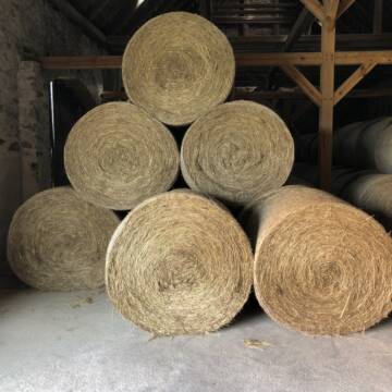
Bio-Heu Rundballen zu verkaufen
Biebertal
Lindenhoefe
@Lindenhoefe
Heu
Lieferant entlädt
Rundballen
Wird verladen
2 weitere...
B+


Futtermittel & Einstreu mit Lieferung!
Schwaara
MK-Agrarprodukte
@MK-Agrarprodukte
Heu
Empfänger lädt ab
Großballen
Regenfrei
2 weitere...
P+

Haferstroh 1.50m Ernte 25 Ausgezeichnete Qualität
Cavertitz
LWB Streubel
@Landwirtschaftsbetr.-Streubel
Stroh
Lieferant entlädt
Rundballen
Regenfrei
3 weitere...
B+

Frisches Stroh zu verkaufen!
Mechtersen
STALL-FREIde Marketing
@STALL-FREI-Marketing
Kaufe frisches Stroh für dein Pferd!
Pferdeheu 1.Schnitt Juli 2025/Rundballen 1.50m
Cavertitz
LWB Streubel
@Landwirtschaftsbetr.-Streubel
Heu
Lieferant entlädt
Rundballen
Bio
Regenfrei
3 weitere...
B+


TaunusHeu staubreduziert
Idstein
Torsten Fischer
@HayClean
Heu
Käufer lädt selbst
Abholung
Lieferung
P+
Deprecated: Creation of dynamic property Zend_View::$pageCount is deprecated in /var/www/stall-frei/htdocs/staging.stall-frei.de/library/vendor/shardj/zf1-future/library/Zend/View/Abstract.php on line 308
Deprecated: Creation of dynamic property Zend_View::$itemCountPerPage is deprecated in /var/www/stall-frei/htdocs/staging.stall-frei.de/library/vendor/shardj/zf1-future/library/Zend/View/Abstract.php on line 308
Deprecated: Creation of dynamic property Zend_View::$first is deprecated in /var/www/stall-frei/htdocs/staging.stall-frei.de/library/vendor/shardj/zf1-future/library/Zend/View/Abstract.php on line 308
Deprecated: Creation of dynamic property Zend_View::$current is deprecated in /var/www/stall-frei/htdocs/staging.stall-frei.de/library/vendor/shardj/zf1-future/library/Zend/View/Abstract.php on line 308
Deprecated: Creation of dynamic property Zend_View::$last is deprecated in /var/www/stall-frei/htdocs/staging.stall-frei.de/library/vendor/shardj/zf1-future/library/Zend/View/Abstract.php on line 308
Deprecated: Creation of dynamic property Zend_View::$previous is deprecated in /var/www/stall-frei/htdocs/staging.stall-frei.de/library/vendor/shardj/zf1-future/library/Zend/View/Abstract.php on line 308
Deprecated: Creation of dynamic property Zend_View::$next is deprecated in /var/www/stall-frei/htdocs/staging.stall-frei.de/library/vendor/shardj/zf1-future/library/Zend/View/Abstract.php on line 308
Deprecated: Creation of dynamic property Zend_View::$pagesInRange is deprecated in /var/www/stall-frei/htdocs/staging.stall-frei.de/library/vendor/shardj/zf1-future/library/Zend/View/Abstract.php on line 308
Deprecated: Creation of dynamic property Zend_View::$firstPageInRange is deprecated in /var/www/stall-frei/htdocs/staging.stall-frei.de/library/vendor/shardj/zf1-future/library/Zend/View/Abstract.php on line 308
Deprecated: Creation of dynamic property Zend_View::$lastPageInRange is deprecated in /var/www/stall-frei/htdocs/staging.stall-frei.de/library/vendor/shardj/zf1-future/library/Zend/View/Abstract.php on line 308
Deprecated: Creation of dynamic property Zend_View::$currentItemCount is deprecated in /var/www/stall-frei/htdocs/staging.stall-frei.de/library/vendor/shardj/zf1-future/library/Zend/View/Abstract.php on line 308
Deprecated: Creation of dynamic property Zend_View::$totalItemCount is deprecated in /var/www/stall-frei/htdocs/staging.stall-frei.de/library/vendor/shardj/zf1-future/library/Zend/View/Abstract.php on line 308
Deprecated: Creation of dynamic property Zend_View::$firstItemNumber is deprecated in /var/www/stall-frei/htdocs/staging.stall-frei.de/library/vendor/shardj/zf1-future/library/Zend/View/Abstract.php on line 308
Deprecated: Creation of dynamic property Zend_View::$lastItemNumber is deprecated in /var/www/stall-frei/htdocs/staging.stall-frei.de/library/vendor/shardj/zf1-future/library/Zend/View/Abstract.php on line 308
Deprecated: Creation of dynamic property Zend_View::$router is deprecated in /var/www/stall-frei/htdocs/staging.stall-frei.de/library/vendor/shardj/zf1-future/library/Zend/View/Abstract.php on line 308
Deprecated: Creation of dynamic property Zend_View::$urlParams is deprecated in /var/www/stall-frei/htdocs/staging.stall-frei.de/library/vendor/shardj/zf1-future/library/Zend/View/Abstract.php on line 308
Deprecated: Creation of dynamic property Zend_View::$showAds is deprecated in /var/www/stall-frei/htdocs/staging.stall-frei.de/library/vendor/shardj/zf1-future/library/Zend/View/Abstract.php on line 308
Deprecated: Creation of dynamic property Zend_View::$objectIds is deprecated in /var/www/stall-frei/htdocs/staging.stall-frei.de/library/vendor/shardj/zf1-future/library/Zend/View/Abstract.php on line 308
Deprecated: Creation of dynamic property Zend_View::$showNavbar is deprecated in /var/www/stall-frei/htdocs/staging.stall-frei.de/library/vendor/shardj/zf1-future/library/Zend/View/Abstract.php on line 308
Deprecated: Creation of dynamic property Zend_View::$showBreadcrumb is deprecated in /var/www/stall-frei/htdocs/staging.stall-frei.de/library/vendor/shardj/zf1-future/library/Zend/View/Abstract.php on line 308
Deprecated: Creation of dynamic property Zend_View::$showFooter is deprecated in /var/www/stall-frei/htdocs/staging.stall-frei.de/library/vendor/shardj/zf1-future/library/Zend/View/Abstract.php on line 308
Deprecated: Creation of dynamic property Zend_View::$showInternalAds is deprecated in /var/www/stall-frei/htdocs/staging.stall-frei.de/library/vendor/shardj/zf1-future/library/Zend/View/Abstract.php on line 308
Deprecated: Creation of dynamic property Zend_View::$blNoContent is deprecated in /var/www/stall-frei/htdocs/staging.stall-frei.de/library/vendor/shardj/zf1-future/library/Zend/View/Abstract.php on line 308
Deprecated: Creation of dynamic property Zend_View::$sMetaDesc is deprecated in /var/www/stall-frei/htdocs/staging.stall-frei.de/library/vendor/shardj/zf1-future/library/Zend/View/Abstract.php on line 308
Deprecated: Creation of dynamic property Zend_View::$useGmaps is deprecated in /var/www/stall-frei/htdocs/staging.stall-frei.de/library/vendor/shardj/zf1-future/library/Zend/View/Abstract.php on line 308
Deprecated: Creation of dynamic property Zend_View::$touches is deprecated in /var/www/stall-frei/htdocs/staging.stall-frei.de/library/vendor/shardj/zf1-future/library/Zend/View/Abstract.php on line 308
Deprecated: Creation of dynamic property Zend_View::$oProject is deprecated in /var/www/stall-frei/htdocs/staging.stall-frei.de/library/vendor/shardj/zf1-future/library/Zend/View/Abstract.php on line 308
Deprecated: Creation of dynamic property Zend_View::$pageHeadline is deprecated in /var/www/stall-frei/htdocs/staging.stall-frei.de/library/vendor/shardj/zf1-future/library/Zend/View/Abstract.php on line 308
Deprecated: Creation of dynamic property Zend_View::$disableLocationField is deprecated in /var/www/stall-frei/htdocs/staging.stall-frei.de/library/vendor/shardj/zf1-future/library/Zend/View/Abstract.php on line 308
Deprecated: Creation of dynamic property Zend_View::$isSearch is deprecated in /var/www/stall-frei/htdocs/staging.stall-frei.de/library/vendor/shardj/zf1-future/library/Zend/View/Abstract.php on line 308
Deprecated: Creation of dynamic property Zend_View::$pageTitle is deprecated in /var/www/stall-frei/htdocs/staging.stall-frei.de/library/vendor/shardj/zf1-future/library/Zend/View/Abstract.php on line 308
Deprecated: Creation of dynamic property Psf_Form_Element_Text::$class is deprecated in /var/www/stall-frei/htdocs/staging.stall-frei.de/library/vendor/shardj/zf1-future/library/Zend/Form/Element.php on line 874
Deprecated: Creation of dynamic property Psf_Form_Element_Text::$size is deprecated in /var/www/stall-frei/htdocs/staging.stall-frei.de/library/vendor/shardj/zf1-future/library/Zend/Form/Element.php on line 874
Deprecated: Creation of dynamic property Psf_Form_Element_Text::$placeholder is deprecated in /var/www/stall-frei/htdocs/staging.stall-frei.de/library/vendor/shardj/zf1-future/library/Zend/Form/Element.php on line 874
Deprecated: Creation of dynamic property Psf_Form_Element_Hidden::$class is deprecated in /var/www/stall-frei/htdocs/staging.stall-frei.de/library/vendor/shardj/zf1-future/library/Zend/Form/Element.php on line 874
Deprecated: Creation of dynamic property Psf_Form_Element_Hidden::$class is deprecated in /var/www/stall-frei/htdocs/staging.stall-frei.de/library/vendor/shardj/zf1-future/library/Zend/Form/Element.php on line 874
Deprecated: Creation of dynamic property Psf_Form_Element_Hidden::$class is deprecated in /var/www/stall-frei/htdocs/staging.stall-frei.de/library/vendor/shardj/zf1-future/library/Zend/Form/Element.php on line 874
Deprecated: Creation of dynamic property Psf_Form_Element_Hidden::$class is deprecated in /var/www/stall-frei/htdocs/staging.stall-frei.de/library/vendor/shardj/zf1-future/library/Zend/Form/Element.php on line 874
Deprecated: Creation of dynamic property Psf_Form_Element_Select::$class is deprecated in /var/www/stall-frei/htdocs/staging.stall-frei.de/library/vendor/shardj/zf1-future/library/Zend/Form/Element.php on line 874
Deprecated: Creation of dynamic property Psf_Form_Element_Select::$class is deprecated in /var/www/stall-frei/htdocs/staging.stall-frei.de/library/vendor/shardj/zf1-future/library/Zend/Form/Element.php on line 874
Deprecated: Creation of dynamic property Psf_Form_Element_Select::$class is deprecated in /var/www/stall-frei/htdocs/staging.stall-frei.de/library/vendor/shardj/zf1-future/library/Zend/Form/Element.php on line 874
Deprecated: Creation of dynamic property Psf_Form_Element_Select::$class is deprecated in /var/www/stall-frei/htdocs/staging.stall-frei.de/library/vendor/shardj/zf1-future/library/Zend/Form/Element.php on line 874
Deprecated: Creation of dynamic property Zend_View::$sort is deprecated in /var/www/stall-frei/htdocs/staging.stall-frei.de/library/vendor/shardj/zf1-future/library/Zend/View/Abstract.php on line 308
Deprecated: Creation of dynamic property Zend_View::$searchLocation is deprecated in /var/www/stall-frei/htdocs/staging.stall-frei.de/library/vendor/shardj/zf1-future/library/Zend/View/Abstract.php on line 308
Deprecated: Creation of dynamic property Zend_View::$locationHint is deprecated in /var/www/stall-frei/htdocs/staging.stall-frei.de/library/vendor/shardj/zf1-future/library/Zend/View/Abstract.php on line 308
Psf_GeoCoder_Abstract::getLocation: Voerde Get Location CachedOrLive
Psf_GeoCoder_Abstract::getCachedOrLive: Voerde
Psf_GeoCoder_Abstract::convertLocationResult
{"documentation":"https:\/\/opencagedata.com\/api","licenses":[{"name":"see attribution guide","url":"https:\/\/opencagedata.com\/credits"}],"results":[{"bounds":{"northeast":{"lat":53.5938997,"lng":9.2830491},"southwest":{"lat":53.4069648,"lng":9.0768949}},"components":{"ISO_3166-1_alpha-2":"DE","ISO_3166-1_alpha-3":"DEU","ISO_3166-2":["DE-NI"],"_category":"place","_normalized_city":"Bremerv\u00f6rde","_type":"city","continent":"Europe","country":"Deutschland","country_code":"de","county":"Landkreis Rotenburg (W\u00fcmme)","political_union":"European Union","postcode":"27432","state":"Niedersachsen","state_code":"NI","town":"Bremerv\u00f6rde"},"confidence":5,"formatted":"27432 Bremerv\u00f6rde, Deutschland","geometry":{"lat":53.4850249,"lng":9.1362085}},{"bounds":{"northeast":{"lat":51.6367697,"lng":6.7219409},"southwest":{"lat":51.563028,"lng":6.5869894}},"components":{"ISO_3166-1_alpha-2":"DE","ISO_3166-1_alpha-3":"DEU","ISO_3166-2":["DE-NW"],"_category":"place","_normalized_city":"Voerde (Niederrhein)","_type":"city","continent":"Europe","country":"Deutschland","country_code":"de","county":"Kreis Wesel","political_union":"European Union","postcode":"46562","state":"Nordrhein-Westfalen","state_code":"NW","town":"Voerde (Niederrhein)"},"confidence":7,"formatted":"46562 Voerde (Niederrhein), Deutschland","geometry":{"lat":51.5975224,"lng":6.6811994}},{"bounds":{"northeast":{"lat":51.3292039,"lng":7.4082954},"southwest":{"lat":51.2892039,"lng":7.3682954}},"components":{"ISO_3166-1_alpha-2":"DE","ISO_3166-1_alpha-3":"DEU","ISO_3166-2":["DE-NW"],"_category":"place","_normalized_city":"Ennepetal","_type":"neighbourhood","continent":"Europe","country":"Deutschland","country_code":"de","county":"Ennepe-Ruhr-Kreis","political_union":"European Union","postcode":"58256","state":"Nordrhein-Westfalen","state_code":"NW","suburb":"Voerde","town":"Ennepetal"},"confidence":7,"formatted":"58256 Ennepetal, Deutschland","geometry":{"lat":51.3092039,"lng":7.3882954}},{"bounds":{"northeast":{"lat":51.6209019,"lng":6.715012},"southwest":{"lat":51.5833184,"lng":6.6469128}},"components":{"ISO_3166-1_alpha-2":"DE","ISO_3166-1_alpha-3":"DEU","ISO_3166-2":["DE-NW"],"_category":"place","_normalized_city":"Voerde (Niederrhein)","_type":"neighbourhood","continent":"Europe","country":"Deutschland","country_code":"de","county":"Kreis Wesel","political_union":"European Union","postcode":"46562","state":"Nordrhein-Westfalen","state_code":"NW","suburb":"Voerde","town":"Voerde (Niederrhein)"},"confidence":7,"formatted":"46562 Voerde (Niederrhein), Deutschland","geometry":{"lat":51.6023652,"lng":6.6845839}},{"components":{"ISO_3166-1_alpha-2":"FR","ISO_3166-1_alpha-3":"FRA","ISO_3166-2":["FR-BFC","FR-21"],"_category":"road","_normalized_city":"M\u00e2lain","_type":"road","city":"M\u00e2lain","continent":"Europe","country":"France","country_code":"fr","county":"C\u00f4te-d'Or","local_authority":"Communaut\u00e9 de communes Ouche et Montagne","political_union":"European Union","postcode":"21410","road":"Chemin de la Grande Verde","state":"Bourgogne-Franche-Comt\u00e9","state_code":"BFC"},"confidence":3,"formatted":"Chemin de la Grande Verde, 21410 M\u00e2lain, France","geometry":{"lat":47.327117,"lng":4.801619}},{"components":{"ISO_3166-1_alpha-2":"FR","ISO_3166-1_alpha-3":"FRA","ISO_3166-2":["FR-PAC","FR-84"],"_category":"road","_normalized_city":"Sarrians","_type":"road","city":"Sarrians","continent":"Europe","country":"France","country_code":"fr","county":"Vaucluse","local_authority":"Communaut\u00e9 d'agglom\u00e9ration Ventoux-Comtat Venaissin","political_union":"European Union","postcode":"84260","road":"Chemin de la Verde","state":"Provence-Alpes-C\u00f4te d'Azur","state_code":"PAC"},"confidence":3,"formatted":"Chemin de la Verde, 84260 Sarrians, France","geometry":{"lat":44.12041,"lng":4.95096}},{"components":{"ISO_3166-1_alpha-2":"FR","ISO_3166-1_alpha-3":"FRA","ISO_3166-2":["FR-BFC","FR-21"],"_category":"road","_normalized_city":"M\u00e2lain","_type":"road","city":"M\u00e2lain","continent":"Europe","country":"France","country_code":"fr","county":"C\u00f4te-d'Or","local_authority":"Communaut\u00e9 de communes Ouche et Montagne","political_union":"European Union","postcode":"21410","road":"Rue de la Verde","state":"Bourgogne-Franche-Comt\u00e9","state_code":"BFC"},"confidence":2,"formatted":"Rue de la Verde, 21410 M\u00e2lain, France","geometry":{"lat":47.327106,"lng":4.801696}},{"components":{"ISO_3166-1_alpha-2":"FR","ISO_3166-1_alpha-3":"FRA","ISO_3166-2":["FR-NOR","FR-76"],"_category":"road","_normalized_city":"Petit-Couronne","_type":"road","city":"Petit-Couronne","continent":"Europe","country":"France","country_code":"fr","county":"Seine-Maritime","local_authority":"M\u00e9tropole Rouen Normandie","political_union":"European Union","postcode":"76650","road":"Rue de Vila Verde","state":"Normandie","state_code":"NOR"},"confidence":2,"formatted":"Rue de Vila Verde, 76650 Petit-Couronne, France","geometry":{"lat":49.396205,"lng":1.029145}},{"components":{"ISO_3166-1_alpha-2":"FR","ISO_3166-1_alpha-3":"FRA","ISO_3166-2":["FR-PAC","FR-84"],"_category":"road","_normalized_city":"Sarrians","_type":"road","city":"Sarrians","continent":"Europe","country":"France","country_code":"fr","county":"Vaucluse","local_authority":"Communaut\u00e9 d'agglom\u00e9ration Ventoux-Comtat Venaissin","political_union":"European Union","postcode":"84260","road":"Ancien chemin de la Verde","state":"Provence-Alpes-C\u00f4te d'Azur","state_code":"PAC"},"confidence":2,"formatted":"Ancien chemin de la Verde, 84260 Sarrians, France","geometry":{"lat":44.1175,"lng":4.949478}},{"components":{"ISO_3166-1_alpha-2":"FR","ISO_3166-1_alpha-3":"FRA","ISO_3166-2":["FR-GES","FR-6AE","FR-67"],"_category":"road","_normalized_city":"Matzenheim","_type":"road","city":"Matzenheim","continent":"Europe","country":"France","country_code":"fr","county":"Bas-Rhin","local_authority":"Communaut\u00e9 de communes du Canton d'Erstein","political_union":"European Union","postcode":"67150","road":"Rue de Werde","state":"Grand Est","state_code":"GES"},"confidence":2,"formatted":"Rue de Werde, 67150 Matzenheim, France","geometry":{"lat":48.388701,"lng":7.630981}}],"status":{"code":200,"message":"OK"},"stay_informed":{"blog":"https:\/\/blog.opencagedata.com","mastodon":"https:\/\/en.osm.town\/@opencage"},"thanks":"For using an OpenCage API","timestamp":{"created_http":"Sun, 08 Feb 2026 02:58:02 GMT","created_unix":1770519482},"total_results":10}Array
(
[0] => stdClass Object
(
[bounds] => stdClass Object
(
[northeast] => stdClass Object
(
[lat] => 53.5938997
[lng] => 9.2830491
)
[southwest] => stdClass Object
(
[lat] => 53.4069648
[lng] => 9.0768949
)
)
[components] => stdClass Object
(
[ISO_3166-1_alpha-2] => DE
[ISO_3166-1_alpha-3] => DEU
[ISO_3166-2] => Array
(
[0] => DE-NI
)
[_category] => place
[_normalized_city] => Bremervörde
[_type] => city
[continent] => Europe
[country] => Deutschland
[country_code] => de
[county] => Landkreis Rotenburg (Wümme)
[political_union] => European Union
[postcode] => 27432
[state] => Niedersachsen
[state_code] => NI
[town] => Bremervörde
)
[confidence] => 5
[formatted] => 27432 Bremervörde, Deutschland
[geometry] => stdClass Object
(
[lat] => 53.4850249
[lng] => 9.1362085
)
)
[1] => stdClass Object
(
[bounds] => stdClass Object
(
[northeast] => stdClass Object
(
[lat] => 51.6367697
[lng] => 6.7219409
)
[southwest] => stdClass Object
(
[lat] => 51.563028
[lng] => 6.5869894
)
)
[components] => stdClass Object
(
[ISO_3166-1_alpha-2] => DE
[ISO_3166-1_alpha-3] => DEU
[ISO_3166-2] => Array
(
[0] => DE-NW
)
[_category] => place
[_normalized_city] => Voerde (Niederrhein)
[_type] => city
[continent] => Europe
[country] => Deutschland
[country_code] => de
[county] => Kreis Wesel
[political_union] => European Union
[postcode] => 46562
[state] => Nordrhein-Westfalen
[state_code] => NW
[town] => Voerde (Niederrhein)
)
[confidence] => 7
[formatted] => 46562 Voerde (Niederrhein), Deutschland
[geometry] => stdClass Object
(
[lat] => 51.5975224
[lng] => 6.6811994
)
)
[2] => stdClass Object
(
[bounds] => stdClass Object
(
[northeast] => stdClass Object
(
[lat] => 51.3292039
[lng] => 7.4082954
)
[southwest] => stdClass Object
(
[lat] => 51.2892039
[lng] => 7.3682954
)
)
[components] => stdClass Object
(
[ISO_3166-1_alpha-2] => DE
[ISO_3166-1_alpha-3] => DEU
[ISO_3166-2] => Array
(
[0] => DE-NW
)
[_category] => place
[_normalized_city] => Ennepetal
[_type] => neighbourhood
[continent] => Europe
[country] => Deutschland
[country_code] => de
[county] => Ennepe-Ruhr-Kreis
[political_union] => European Union
[postcode] => 58256
[state] => Nordrhein-Westfalen
[state_code] => NW
[suburb] => Voerde
[town] => Ennepetal
)
[confidence] => 7
[formatted] => 58256 Ennepetal, Deutschland
[geometry] => stdClass Object
(
[lat] => 51.3092039
[lng] => 7.3882954
)
)
[3] => stdClass Object
(
[bounds] => stdClass Object
(
[northeast] => stdClass Object
(
[lat] => 51.6209019
[lng] => 6.715012
)
[southwest] => stdClass Object
(
[lat] => 51.5833184
[lng] => 6.6469128
)
)
[components] => stdClass Object
(
[ISO_3166-1_alpha-2] => DE
[ISO_3166-1_alpha-3] => DEU
[ISO_3166-2] => Array
(
[0] => DE-NW
)
[_category] => place
[_normalized_city] => Voerde (Niederrhein)
[_type] => neighbourhood
[continent] => Europe
[country] => Deutschland
[country_code] => de
[county] => Kreis Wesel
[political_union] => European Union
[postcode] => 46562
[state] => Nordrhein-Westfalen
[state_code] => NW
[suburb] => Voerde
[town] => Voerde (Niederrhein)
)
[confidence] => 7
[formatted] => 46562 Voerde (Niederrhein), Deutschland
[geometry] => stdClass Object
(
[lat] => 51.6023652
[lng] => 6.6845839
)
)
[4] => stdClass Object
(
[components] => stdClass Object
(
[ISO_3166-1_alpha-2] => FR
[ISO_3166-1_alpha-3] => FRA
[ISO_3166-2] => Array
(
[0] => FR-BFC
[1] => FR-21
)
[_category] => road
[_normalized_city] => Mâlain
[_type] => road
[city] => Mâlain
[continent] => Europe
[country] => France
[country_code] => fr
[county] => Côte-d'Or
[local_authority] => Communauté de communes Ouche et Montagne
[political_union] => European Union
[postcode] => 21410
[road] => Chemin de la Grande Verde
[state] => Bourgogne-Franche-Comté
[state_code] => BFC
)
[confidence] => 3
[formatted] => Chemin de la Grande Verde, 21410 Mâlain, France
[geometry] => stdClass Object
(
[lat] => 47.327117
[lng] => 4.801619
)
)
[5] => stdClass Object
(
[components] => stdClass Object
(
[ISO_3166-1_alpha-2] => FR
[ISO_3166-1_alpha-3] => FRA
[ISO_3166-2] => Array
(
[0] => FR-PAC
[1] => FR-84
)
[_category] => road
[_normalized_city] => Sarrians
[_type] => road
[city] => Sarrians
[continent] => Europe
[country] => France
[country_code] => fr
[county] => Vaucluse
[local_authority] => Communauté d'agglomération Ventoux-Comtat Venaissin
[political_union] => European Union
[postcode] => 84260
[road] => Chemin de la Verde
[state] => Provence-Alpes-Côte d'Azur
[state_code] => PAC
)
[confidence] => 3
[formatted] => Chemin de la Verde, 84260 Sarrians, France
[geometry] => stdClass Object
(
[lat] => 44.12041
[lng] => 4.95096
)
)
[6] => stdClass Object
(
[components] => stdClass Object
(
[ISO_3166-1_alpha-2] => FR
[ISO_3166-1_alpha-3] => FRA
[ISO_3166-2] => Array
(
[0] => FR-BFC
[1] => FR-21
)
[_category] => road
[_normalized_city] => Mâlain
[_type] => road
[city] => Mâlain
[continent] => Europe
[country] => France
[country_code] => fr
[county] => Côte-d'Or
[local_authority] => Communauté de communes Ouche et Montagne
[political_union] => European Union
[postcode] => 21410
[road] => Rue de la Verde
[state] => Bourgogne-Franche-Comté
[state_code] => BFC
)
[confidence] => 2
[formatted] => Rue de la Verde, 21410 Mâlain, France
[geometry] => stdClass Object
(
[lat] => 47.327106
[lng] => 4.801696
)
)
[7] => stdClass Object
(
[components] => stdClass Object
(
[ISO_3166-1_alpha-2] => FR
[ISO_3166-1_alpha-3] => FRA
[ISO_3166-2] => Array
(
[0] => FR-NOR
[1] => FR-76
)
[_category] => road
[_normalized_city] => Petit-Couronne
[_type] => road
[city] => Petit-Couronne
[continent] => Europe
[country] => France
[country_code] => fr
[county] => Seine-Maritime
[local_authority] => Métropole Rouen Normandie
[political_union] => European Union
[postcode] => 76650
[road] => Rue de Vila Verde
[state] => Normandie
[state_code] => NOR
)
[confidence] => 2
[formatted] => Rue de Vila Verde, 76650 Petit-Couronne, France
[geometry] => stdClass Object
(
[lat] => 49.396205
[lng] => 1.029145
)
)
[8] => stdClass Object
(
[components] => stdClass Object
(
[ISO_3166-1_alpha-2] => FR
[ISO_3166-1_alpha-3] => FRA
[ISO_3166-2] => Array
(
[0] => FR-PAC
[1] => FR-84
)
[_category] => road
[_normalized_city] => Sarrians
[_type] => road
[city] => Sarrians
[continent] => Europe
[country] => France
[country_code] => fr
[county] => Vaucluse
[local_authority] => Communauté d'agglomération Ventoux-Comtat Venaissin
[political_union] => European Union
[postcode] => 84260
[road] => Ancien chemin de la Verde
[state] => Provence-Alpes-Côte d'Azur
[state_code] => PAC
)
[confidence] => 2
[formatted] => Ancien chemin de la Verde, 84260 Sarrians, France
[geometry] => stdClass Object
(
[lat] => 44.1175
[lng] => 4.949478
)
)
[9] => stdClass Object
(
[components] => stdClass Object
(
[ISO_3166-1_alpha-2] => FR
[ISO_3166-1_alpha-3] => FRA
[ISO_3166-2] => Array
(
[0] => FR-GES
[1] => FR-6AE
[2] => FR-67
)
[_category] => road
[_normalized_city] => Matzenheim
[_type] => road
[city] => Matzenheim
[continent] => Europe
[country] => France
[country_code] => fr
[county] => Bas-Rhin
[local_authority] => Communauté de communes du Canton d'Erstein
[political_union] => European Union
[postcode] => 67150
[road] => Rue de Werde
[state] => Grand Est
[state_code] => GES
)
[confidence] => 2
[formatted] => Rue de Werde, 67150 Matzenheim, France
[geometry] => stdClass Object
(
[lat] => 48.388701
[lng] => 7.630981
)
)
)
Psf_GeoCoder_OpenCageData::getKeyMap: 0
stdClass Object
(
    [bounds] => stdClass Object
        (
            [northeast] => stdClass Object
                (
                    [lat] => 53.5938997
                    [lng] => 9.2830491
                )

            [southwest] => stdClass Object
                (
                    [lat] => 53.4069648
                    [lng] => 9.0768949
                )

        )

    [components] => stdClass Object
        (
            [ISO_3166-1_alpha-2] => DE
            [ISO_3166-1_alpha-3] => DEU
            [ISO_3166-2] => Array
                (
                    [0] => DE-NI
                )

            [_category] => place
            [_normalized_city] => Bremervörde
            [_type] => city
            [continent] => Europe
            [country] => Deutschland
            [country_code] => de
            [county] => Landkreis Rotenburg (Wümme)
            [political_union] => European Union
            [postcode] => 27432
            [state] => Niedersachsen
            [state_code] => NI
            [town] => Bremervörde
        )

    [confidence] => 5
    [formatted] => 27432 Bremervörde, Deutschland
    [geometry] => stdClass Object
        (
            [lat] => 53.4850249
            [lng] => 9.1362085
        )

)
Psf_GeoCoder_OpenCageData::getCounty: Rotenburg (Wümme)
Psf_GeoCoder_OpenCageData::addMissingData REFETCH!
Array
(
    [address] => 27432 Bremervörde, Deutschland
    [type] => city
    [street] =>
    [city] => Bremervörde
    [county] => Rotenburg (Wümme)
    [state] => Niedersachsen
    [zip] => 27432
    [country] => Deutschland
    [suburb] =>
    [countrycode] => de
    [latitude] => 53.4850249
    [longitude] => 9.1362085
    [accuracy] => 1
    [confidence] => 5
    [bounds] => stdClass Object
        (
            [northeast] => stdClass Object
                (
                    [lat] => 53.5938997
                    [lng] => 9.2830491
                )

            [southwest] => stdClass Object
                (
                    [lat] => 53.4069648
                    [lng] => 9.0768949
                )

        )

)
reformat!
Array
(
    [address] => 27432 Bremervörde, Deutschland
    [type] => city
    [street] =>
    [city] => Bremervörde
    [county] => Rotenburg (Wümme)
    [state] => Niedersachsen
    [zip] => 27432
    [country] => Deutschland
    [suburb] =>
    [countrycode] => de
    [latitude] => 53.4850249
    [longitude] => 9.1362085
    [accuracy] => 1
    [confidence] => 5
    [bounds] => stdClass Object
        (
            [northeast] => stdClass Object
                (
                    [lat] => 53.5938997
                    [lng] => 9.2830491
                )

            [southwest] => stdClass Object
                (
                    [lat] => 53.4069648
                    [lng] => 9.0768949
                )

        )

    [place] => 27432 Bremervörde, Niedersachsen
    [hash] => 20be01480797791e0075ed1724bc075b
)
Psf_GeoCoder_OpenCageData::getKeyMap: 1
stdClass Object
(
    [bounds] => stdClass Object
        (
            [northeast] => stdClass Object
                (
                    [lat] => 51.6367697
                    [lng] => 6.7219409
                )

            [southwest] => stdClass Object
                (
                    [lat] => 51.563028
                    [lng] => 6.5869894
                )

        )

    [components] => stdClass Object
        (
            [ISO_3166-1_alpha-2] => DE
            [ISO_3166-1_alpha-3] => DEU
            [ISO_3166-2] => Array
                (
                    [0] => DE-NW
                )

            [_category] => place
            [_normalized_city] => Voerde (Niederrhein)
            [_type] => city
            [continent] => Europe
            [country] => Deutschland
            [country_code] => de
            [county] => Kreis Wesel
            [political_union] => European Union
            [postcode] => 46562
            [state] => Nordrhein-Westfalen
            [state_code] => NW
            [town] => Voerde (Niederrhein)
        )

    [confidence] => 7
    [formatted] => 46562 Voerde (Niederrhein), Deutschland
    [geometry] => stdClass Object
        (
            [lat] => 51.5975224
            [lng] => 6.6811994
        )

)
Psf_GeoCoder_OpenCageData::getCounty: Wesel
Psf_GeoCoder_OpenCageData::addMissingData REFETCH!
Array
(
    [address] => 46562 Voerde (Niederrhein), Deutschland
    [type] => city
    [street] =>
    [city] => Voerde (Niederrhein)
    [county] => Wesel
    [state] => Nordrhein-Westfalen
    [zip] => 46562
    [country] => Deutschland
    [suburb] =>
    [countrycode] => de
    [latitude] => 51.5975224
    [longitude] => 6.6811994
    [accuracy] => 1
    [confidence] => 7
    [bounds] => stdClass Object
        (
            [northeast] => stdClass Object
                (
                    [lat] => 51.6367697
                    [lng] => 6.7219409
                )

            [southwest] => stdClass Object
                (
                    [lat] => 51.563028
                    [lng] => 6.5869894
                )

        )

)
reformat!
Array
(
    [address] => 46562 Voerde (Niederrhein), Deutschland
    [type] => city
    [street] =>
    [city] => Voerde (Niederrhein)
    [county] => Wesel
    [state] => Nordrhein-Westfalen
    [zip] => 46562
    [country] => Deutschland
    [suburb] =>
    [countrycode] => de
    [latitude] => 51.5975224
    [longitude] => 6.6811994
    [accuracy] => 1
    [confidence] => 7
    [bounds] => stdClass Object
        (
            [northeast] => stdClass Object
                (
                    [lat] => 51.6367697
                    [lng] => 6.7219409
                )

            [southwest] => stdClass Object
                (
                    [lat] => 51.563028
                    [lng] => 6.5869894
                )

        )

    [place] => 46562 Voerde (Niederrhein), Nordrhein-Westfalen
    [hash] => 1590c67eab8b93bab16a121c0fab33e7
)
Psf_GeoCoder_OpenCageData::getKeyMap: 2
stdClass Object
(
    [bounds] => stdClass Object
        (
            [northeast] => stdClass Object
                (
                    [lat] => 51.3292039
                    [lng] => 7.4082954
                )

            [southwest] => stdClass Object
                (
                    [lat] => 51.2892039
                    [lng] => 7.3682954
                )

        )

    [components] => stdClass Object
        (
            [ISO_3166-1_alpha-2] => DE
            [ISO_3166-1_alpha-3] => DEU
            [ISO_3166-2] => Array
                (
                    [0] => DE-NW
                )

            [_category] => place
            [_normalized_city] => Ennepetal
            [_type] => neighbourhood
            [continent] => Europe
            [country] => Deutschland
            [country_code] => de
            [county] => Ennepe-Ruhr-Kreis
            [political_union] => European Union
            [postcode] => 58256
            [state] => Nordrhein-Westfalen
            [state_code] => NW
            [suburb] => Voerde
            [town] => Ennepetal
        )

    [confidence] => 7
    [formatted] => 58256 Ennepetal, Deutschland
    [geometry] => stdClass Object
        (
            [lat] => 51.3092039
            [lng] => 7.3882954
        )

)
Psf_GeoCoder_OpenCageData::getCounty: Ennepe-Ruhr-Kreis
Psf_GeoCoder_OpenCageData::addMissingData REFETCH!
Array
(
    [address] => 58256 Ennepetal, Deutschland
    [type] => neighbourhood
    [street] =>
    [city] => Ennepetal
    [county] => Ennepe-Ruhr-Kreis
    [state] => Nordrhein-Westfalen
    [zip] => 58256
    [country] => Deutschland
    [suburb] => Voerde
    [countrycode] => de
    [latitude] => 51.3092039
    [longitude] => 7.3882954
    [accuracy] => 1
    [confidence] => 7
    [bounds] => stdClass Object
        (
            [northeast] => stdClass Object
                (
                    [lat] => 51.3292039
                    [lng] => 7.4082954
                )

            [southwest] => stdClass Object
                (
                    [lat] => 51.2892039
                    [lng] => 7.3682954
                )

        )

)
reformat!
Array
(
    [address] => 58256 Ennepetal, Deutschland
    [type] => neighbourhood
    [street] =>
    [city] => Ennepetal
    [county] => Ennepe-Ruhr-Kreis
    [state] => Nordrhein-Westfalen
    [zip] => 58256
    [country] => Deutschland
    [suburb] => Voerde
    [countrycode] => de
    [latitude] => 51.3092039
    [longitude] => 7.3882954
    [accuracy] => 1
    [confidence] => 7
    [bounds] => stdClass Object
        (
            [northeast] => stdClass Object
                (
                    [lat] => 51.3292039
                    [lng] => 7.4082954
                )

            [southwest] => stdClass Object
                (
                    [lat] => 51.2892039
                    [lng] => 7.3682954
                )

        )

    [place] => 58256 Ennepetal, Nordrhein-Westfalen
    [hash] => 04455b79f42874cc06969eebb83a9556
)
Psf_GeoCoder_OpenCageData::getKeyMap: 3
stdClass Object
(
    [bounds] => stdClass Object
        (
            [northeast] => stdClass Object
                (
                    [lat] => 51.6209019
                    [lng] => 6.715012
                )

            [southwest] => stdClass Object
                (
                    [lat] => 51.5833184
                    [lng] => 6.6469128
                )

        )

    [components] => stdClass Object
        (
            [ISO_3166-1_alpha-2] => DE
            [ISO_3166-1_alpha-3] => DEU
            [ISO_3166-2] => Array
                (
                    [0] => DE-NW
                )

            [_category] => place
            [_normalized_city] => Voerde (Niederrhein)
            [_type] => neighbourhood
            [continent] => Europe
            [country] => Deutschland
            [country_code] => de
            [county] => Kreis Wesel
            [political_union] => European Union
            [postcode] => 46562
            [state] => Nordrhein-Westfalen
            [state_code] => NW
            [suburb] => Voerde
            [town] => Voerde (Niederrhein)
        )

    [confidence] => 7
    [formatted] => 46562 Voerde (Niederrhein), Deutschland
    [geometry] => stdClass Object
        (
            [lat] => 51.6023652
            [lng] => 6.6845839
        )

)
Psf_GeoCoder_OpenCageData::getCounty: Wesel
Psf_GeoCoder_OpenCageData::addMissingData REFETCH!
Array
(
    [address] => 46562 Voerde (Niederrhein), Deutschland
    [type] => neighbourhood
    [street] =>
    [city] => Voerde (Niederrhein)
    [county] => Wesel
    [state] => Nordrhein-Westfalen
    [zip] => 46562
    [country] => Deutschland
    [suburb] => Voerde
    [countrycode] => de
    [latitude] => 51.6023652
    [longitude] => 6.6845839
    [accuracy] => 1
    [confidence] => 7
    [bounds] => stdClass Object
        (
            [northeast] => stdClass Object
                (
                    [lat] => 51.6209019
                    [lng] => 6.715012
                )

            [southwest] => stdClass Object
                (
                    [lat] => 51.5833184
                    [lng] => 6.6469128
                )

        )

)
reformat!
Array
(
    [address] => 46562 Voerde (Niederrhein), Deutschland
    [type] => neighbourhood
    [street] =>
    [city] => Voerde (Niederrhein)
    [county] => Wesel
    [state] => Nordrhein-Westfalen
    [zip] => 46562
    [country] => Deutschland
    [suburb] => Voerde
    [countrycode] => de
    [latitude] => 51.6023652
    [longitude] => 6.6845839
    [accuracy] => 1
    [confidence] => 7
    [bounds] => stdClass Object
        (
            [northeast] => stdClass Object
                (
                    [lat] => 51.6209019
                    [lng] => 6.715012
                )

            [southwest] => stdClass Object
                (
                    [lat] => 51.5833184
                    [lng] => 6.6469128
                )

        )

    [place] => 46562 Voerde (Niederrhein), Nordrhein-Westfalen
    [hash] => 1590c67eab8b93bab16a121c0fab33e7
)
Psf_GeoCoder_OpenCageData::getKeyMap: 4
stdClass Object
(
    [components] => stdClass Object
        (
            [ISO_3166-1_alpha-2] => FR
            [ISO_3166-1_alpha-3] => FRA
            [ISO_3166-2] => Array
                (
                    [0] => FR-BFC
                    [1] => FR-21
                )

            [_category] => road
            [_normalized_city] => Mâlain
            [_type] => road
            [city] => Mâlain
            [continent] => Europe
            [country] => France
            [country_code] => fr
            [county] => Côte-d'Or
            [local_authority] => Communauté de communes Ouche et Montagne
            [political_union] => European Union
            [postcode] => 21410
            [road] => Chemin de la Grande Verde
            [state] => Bourgogne-Franche-Comté
            [state_code] => BFC
        )

    [confidence] => 3
    [formatted] => Chemin de la Grande Verde, 21410 Mâlain, France
    [geometry] => stdClass Object
        (
            [lat] => 47.327117
            [lng] => 4.801619
        )

)
Psf_GeoCoder_OpenCageData::getCounty: Côte-d'Or
Psf_GeoCoder_OpenCageData::addMissingData REFETCH!
Array
(
    [address] => Chemin de la Grande Verde, 21410 Mâlain, France
    [type] => road
    [street] => Chemin de la Grande Verde
    [city] => Mâlain
    [county] => Côte-d'Or
    [state] => Bourgogne-Franche-Comté
    [zip] => 21410
    [country] => France
    [suburb] =>
    [countrycode] => fr
    [latitude] => 47.327117
    [longitude] => 4.801619
    [accuracy] => 1
    [confidence] => 3
    [bounds] =>
)
reformat!
Array
(
    [address] => Chemin de la Grande Verde, 21410 Mâlain, France
    [type] => road
    [street] => Chemin de la Grande Verde
    [city] => Mâlain
    [county] => Côte-d'Or
    [state] => Bourgogne-Franche-Comté
    [zip] => 21410
    [country] => France
    [suburb] =>
    [countrycode] => fr
    [latitude] => 47.327117
    [longitude] => 4.801619
    [accuracy] => 1
    [confidence] => 3
    [bounds] =>
    [place] => Chemin de la Grande Verde, 21410 Mâlain, Bourgogne-Franche-Comté
    [hash] => ffea45f812cc212ea7a20411712c6ed5
)
Psf_GeoCoder_OpenCageData::getKeyMap: 5
stdClass Object
(
    [components] => stdClass Object
        (
            [ISO_3166-1_alpha-2] => FR
            [ISO_3166-1_alpha-3] => FRA
            [ISO_3166-2] => Array
                (
                    [0] => FR-PAC
                    [1] => FR-84
                )

            [_category] => road
            [_normalized_city] => Sarrians
            [_type] => road
            [city] => Sarrians
            [continent] => Europe
            [country] => France
            [country_code] => fr
            [county] => Vaucluse
            [local_authority] => Communauté d'agglomération Ventoux-Comtat Venaissin
            [political_union] => European Union
            [postcode] => 84260
            [road] => Chemin de la Verde
            [state] => Provence-Alpes-Côte d'Azur
            [state_code] => PAC
        )

    [confidence] => 3
    [formatted] => Chemin de la Verde, 84260 Sarrians, France
    [geometry] => stdClass Object
        (
            [lat] => 44.12041
            [lng] => 4.95096
        )

)
Psf_GeoCoder_OpenCageData::getCounty: Vaucluse
Psf_GeoCoder_OpenCageData::addMissingData REFETCH!
Array
(
    [address] => Chemin de la Verde, 84260 Sarrians, France
    [type] => road
    [street] => Chemin de la Verde
    [city] => Sarrians
    [county] => Vaucluse
    [state] => Provence-Alpes-Côte d'Azur
    [zip] => 84260
    [country] => France
    [suburb] =>
    [countrycode] => fr
    [latitude] => 44.12041
    [longitude] => 4.95096
    [accuracy] => 1
    [confidence] => 3
    [bounds] =>
)
reformat!
Array
(
    [address] => Chemin de la Verde, 84260 Sarrians, France
    [type] => road
    [street] => Chemin de la Verde
    [city] => Sarrians
    [county] => Vaucluse
    [state] => Provence-Alpes-Côte d'Azur
    [zip] => 84260
    [country] => France
    [suburb] =>
    [countrycode] => fr
    [latitude] => 44.12041
    [longitude] => 4.95096
    [accuracy] => 1
    [confidence] => 3
    [bounds] =>
    [place] => Chemin de la Verde, 84260 Sarrians, Provence-Alpes-Côte d'Azur
    [hash] => bcfa2fadfe20542f647a7975898c53e4
)
Psf_GeoCoder_OpenCageData::getKeyMap: 6
stdClass Object
(
    [components] => stdClass Object
        (
            [ISO_3166-1_alpha-2] => FR
            [ISO_3166-1_alpha-3] => FRA
            [ISO_3166-2] => Array
                (
                    [0] => FR-BFC
                    [1] => FR-21
                )

            [_category] => road
            [_normalized_city] => Mâlain
            [_type] => road
            [city] => Mâlain
            [continent] => Europe
            [country] => France
            [country_code] => fr
            [county] => Côte-d'Or
            [local_authority] => Communauté de communes Ouche et Montagne
            [political_union] => European Union
            [postcode] => 21410
            [road] => Rue de la Verde
            [state] => Bourgogne-Franche-Comté
            [state_code] => BFC
        )

    [confidence] => 2
    [formatted] => Rue de la Verde, 21410 Mâlain, France
    [geometry] => stdClass Object
        (
            [lat] => 47.327106
            [lng] => 4.801696
        )

)
Psf_GeoCoder_OpenCageData::getCounty: Côte-d'Or
Psf_GeoCoder_OpenCageData::addMissingData REFETCH!
Array
(
    [address] => Rue de la Verde, 21410 Mâlain, France
    [type] => road
    [street] => Rue de la Verde
    [city] => Mâlain
    [county] => Côte-d'Or
    [state] => Bourgogne-Franche-Comté
    [zip] => 21410
    [country] => France
    [suburb] =>
    [countrycode] => fr
    [latitude] => 47.327106
    [longitude] => 4.801696
    [accuracy] => 1
    [confidence] => 2
    [bounds] =>
)
reformat!
Array
(
    [address] => Rue de la Verde, 21410 Mâlain, France
    [type] => road
    [street] => Rue de la Verde
    [city] => Mâlain
    [county] => Côte-d'Or
    [state] => Bourgogne-Franche-Comté
    [zip] => 21410
    [country] => France
    [suburb] =>
    [countrycode] => fr
    [latitude] => 47.327106
    [longitude] => 4.801696
    [accuracy] => 1
    [confidence] => 2
    [bounds] =>
    [place] => Rue de la Verde, 21410 Mâlain, Bourgogne-Franche-Comté
    [hash] => 3e27fd05494ccb75df159f2d8345ccd8
)
Psf_GeoCoder_OpenCageData::getKeyMap: 7
stdClass Object
(
    [components] => stdClass Object
        (
            [ISO_3166-1_alpha-2] => FR
            [ISO_3166-1_alpha-3] => FRA
            [ISO_3166-2] => Array
                (
                    [0] => FR-NOR
                    [1] => FR-76
                )

            [_category] => road
            [_normalized_city] => Petit-Couronne
            [_type] => road
            [city] => Petit-Couronne
            [continent] => Europe
            [country] => France
            [country_code] => fr
            [county] => Seine-Maritime
            [local_authority] => Métropole Rouen Normandie
            [political_union] => European Union
            [postcode] => 76650
            [road] => Rue de Vila Verde
            [state] => Normandie
            [state_code] => NOR
        )

    [confidence] => 2
    [formatted] => Rue de Vila Verde, 76650 Petit-Couronne, France
    [geometry] => stdClass Object
        (
            [lat] => 49.396205
            [lng] => 1.029145
        )

)
Psf_GeoCoder_OpenCageData::getCounty: Seine-Maritime
Psf_GeoCoder_OpenCageData::addMissingData REFETCH!
Array
(
    [address] => Rue de Vila Verde, 76650 Petit-Couronne, France
    [type] => road
    [street] => Rue de Vila Verde
    [city] => Petit-Couronne
    [county] => Seine-Maritime
    [state] => Normandie
    [zip] => 76650
    [country] => France
    [suburb] =>
    [countrycode] => fr
    [latitude] => 49.396205
    [longitude] => 1.029145
    [accuracy] => 1
    [confidence] => 2
    [bounds] =>
)
reformat!
Array
(
    [address] => Rue de Vila Verde, 76650 Petit-Couronne, France
    [type] => road
    [street] => Rue de Vila Verde
    [city] => Petit-Couronne
    [county] => Seine-Maritime
    [state] => Normandie
    [zip] => 76650
    [country] => France
    [suburb] =>
    [countrycode] => fr
    [latitude] => 49.396205
    [longitude] => 1.029145
    [accuracy] => 1
    [confidence] => 2
    [bounds] =>
    [place] => Rue de Vila Verde, 76650 Petit-Couronne, Normandie
    [hash] => 450546148729cd40f4b136629df677db
)
Psf_GeoCoder_OpenCageData::getKeyMap: 8
stdClass Object
(
    [components] => stdClass Object
        (
            [ISO_3166-1_alpha-2] => FR
            [ISO_3166-1_alpha-3] => FRA
            [ISO_3166-2] => Array
                (
                    [0] => FR-PAC
                    [1] => FR-84
                )

            [_category] => road
            [_normalized_city] => Sarrians
            [_type] => road
            [city] => Sarrians
            [continent] => Europe
            [country] => France
            [country_code] => fr
            [county] => Vaucluse
            [local_authority] => Communauté d'agglomération Ventoux-Comtat Venaissin
            [political_union] => European Union
            [postcode] => 84260
            [road] => Ancien chemin de la Verde
            [state] => Provence-Alpes-Côte d'Azur
            [state_code] => PAC
        )

    [confidence] => 2
    [formatted] => Ancien chemin de la Verde, 84260 Sarrians, France
    [geometry] => stdClass Object
        (
            [lat] => 44.1175
            [lng] => 4.949478
        )

)
Psf_GeoCoder_OpenCageData::getCounty: Vaucluse
Psf_GeoCoder_OpenCageData::addMissingData REFETCH!
Array
(
    [address] => Ancien chemin de la Verde, 84260 Sarrians, France
    [type] => road
    [street] => Ancien chemin de la Verde
    [city] => Sarrians
    [county] => Vaucluse
    [state] => Provence-Alpes-Côte d'Azur
    [zip] => 84260
    [country] => France
    [suburb] =>
    [countrycode] => fr
    [latitude] => 44.1175
    [longitude] => 4.949478
    [accuracy] => 1
    [confidence] => 2
    [bounds] =>
)
reformat!
Array
(
    [address] => Ancien chemin de la Verde, 84260 Sarrians, France
    [type] => road
    [street] => Ancien chemin de la Verde
    [city] => Sarrians
    [county] => Vaucluse
    [state] => Provence-Alpes-Côte d'Azur
    [zip] => 84260
    [country] => France
    [suburb] =>
    [countrycode] => fr
    [latitude] => 44.1175
    [longitude] => 4.949478
    [accuracy] => 1
    [confidence] => 2
    [bounds] =>
    [place] => Ancien chemin de la Verde, 84260 Sarrians, Provence-Alpes-Côte d'Azur
    [hash] => afc61d5606593ae80851810f641d9473
)
Psf_GeoCoder_OpenCageData::getKeyMap: 9
stdClass Object
(
    [components] => stdClass Object
        (
            [ISO_3166-1_alpha-2] => FR
            [ISO_3166-1_alpha-3] => FRA
            [ISO_3166-2] => Array
                (
                    [0] => FR-GES
                    [1] => FR-6AE
                    [2] => FR-67
                )

            [_category] => road
            [_normalized_city] => Matzenheim
            [_type] => road
            [city] => Matzenheim
            [continent] => Europe
            [country] => France
            [country_code] => fr
            [county] => Bas-Rhin
            [local_authority] => Communauté de communes du Canton d'Erstein
            [political_union] => European Union
            [postcode] => 67150
            [road] => Rue de Werde
            [state] => Grand Est
            [state_code] => GES
        )

    [confidence] => 2
    [formatted] => Rue de Werde, 67150 Matzenheim, France
    [geometry] => stdClass Object
        (
            [lat] => 48.388701
            [lng] => 7.630981
        )

)
Psf_GeoCoder_OpenCageData::getCounty: Bas-Rhin
Psf_GeoCoder_OpenCageData::addMissingData REFETCH!
Array
(
    [address] => Rue de Werde, 67150 Matzenheim, France
    [type] => road
    [street] => Rue de Werde
    [city] => Matzenheim
    [county] => Bas-Rhin
    [state] => Grand Est
    [zip] => 67150
    [country] => France
    [suburb] =>
    [countrycode] => fr
    [latitude] => 48.388701
    [longitude] => 7.630981
    [accuracy] => 1
    [confidence] => 2
    [bounds] =>
)
reformat!
Array
(
    [address] => Rue de Werde, 67150 Matzenheim, France
    [type] => road
    [street] => Rue de Werde
    [city] => Matzenheim
    [county] => Bas-Rhin
    [state] => Grand Est
    [zip] => 67150
    [country] => France
    [suburb] =>
    [countrycode] => fr
    [latitude] => 48.388701
    [longitude] => 7.630981
    [accuracy] => 1
    [confidence] => 2
    [bounds] =>
    [place] => Rue de Werde, 67150 Matzenheim, Grand Est
    [hash] => 3396c3295c45c545ac5c24cd4c6d7e38
)
Deprecated: Creation of dynamic property Zend_View::$locationHintStyle is deprecated in /var/www/stall-frei/htdocs/staging.stall-frei.de/library/vendor/shardj/zf1-future/library/Zend/View/Abstract.php on line 308
Deprecated: Creation of dynamic property Zend_View::$adGeoLocation is deprecated in /var/www/stall-frei/htdocs/staging.stall-frei.de/library/vendor/shardj/zf1-future/library/Zend/View/Abstract.php on line 308
Deprecated: Creation of dynamic property Zend_View::$recordCount is deprecated in /var/www/stall-frei/htdocs/staging.stall-frei.de/library/vendor/shardj/zf1-future/library/Zend/View/Abstract.php on line 308
Deprecated: Creation of dynamic property Zend_View::$paginationParams is deprecated in /var/www/stall-frei/htdocs/staging.stall-frei.de/library/vendor/shardj/zf1-future/library/Zend/View/Abstract.php on line 308
Deprecated: Creation of dynamic property Zend_View::$objectPaginator is deprecated in /var/www/stall-frei/htdocs/staging.stall-frei.de/library/vendor/shardj/zf1-future/library/Zend/View/Abstract.php on line 308
Deprecated: Creation of dynamic property Zend_View::$featuredObjects is deprecated in /var/www/stall-frei/htdocs/staging.stall-frei.de/library/vendor/shardj/zf1-future/library/Zend/View/Abstract.php on line 308
Deprecated: Creation of dynamic property Zend_View::$hints is deprecated in /var/www/stall-frei/htdocs/staging.stall-frei.de/library/vendor/shardj/zf1-future/library/Zend/View/Abstract.php on line 308
Deprecated: Creation of dynamic property Zend_View::$attributeHints is deprecated in /var/www/stall-frei/htdocs/staging.stall-frei.de/library/vendor/shardj/zf1-future/library/Zend/View/Abstract.php on line 308
Deprecated: Creation of dynamic property Zend_View::$oSearchForm is deprecated in /var/www/stall-frei/htdocs/staging.stall-frei.de/library/vendor/shardj/zf1-future/library/Zend/View/Abstract.php on line 308