Deprecated: Creation of dynamic property Zend_View::$sMode is deprecated in /var/www/stall-frei/htdocs/staging.stall-frei.de/library/vendor/shardj/zf1-future/library/Zend/View/Abstract.php on line 308
Heu, Stroh oder Futter in Lößnig
Gesucht wird in "Willi-Bredel-Straße 15, 04279 Lößnig"
93 Einträge
Deprecated: Creation of dynamic property Zend_View::$listObjects is deprecated in /var/www/stall-frei/htdocs/staging.stall-frei.de/library/vendor/shardj/zf1-future/library/Zend/View/Abstract.php on line 308
Deprecated: Creation of dynamic property Zend_View::$listMode is deprecated in /var/www/stall-frei/htdocs/staging.stall-frei.de/library/vendor/shardj/zf1-future/library/Zend/View/Abstract.php on line 308
Deprecated: Creation of dynamic property Zend_View::$renderedObjects is deprecated in /var/www/stall-frei/htdocs/staging.stall-frei.de/library/vendor/shardj/zf1-future/library/Zend/View/Abstract.php on line 308
Deprecated: Creation of dynamic property Zend_View::$index is deprecated in /var/www/stall-frei/htdocs/staging.stall-frei.de/library/vendor/shardj/zf1-future/library/Zend/View/Abstract.php on line 308
Deprecated: Creation of dynamic property Zend_View::$displayMode is deprecated in /var/www/stall-frei/htdocs/staging.stall-frei.de/library/vendor/shardj/zf1-future/library/Zend/View/Abstract.php on line 308
Deprecated: Creation of dynamic property Zend_View::$remarketingIds is deprecated in /var/www/stall-frei/htdocs/staging.stall-frei.de/library/vendor/shardj/zf1-future/library/Zend/View/Abstract.php on line 308
Deprecated: Creation of dynamic property Zend_View::$listItem is deprecated in /var/www/stall-frei/htdocs/staging.stall-frei.de/library/vendor/shardj/zf1-future/library/Zend/View/Abstract.php on line 308
Deprecated: Creation of dynamic property Zend_View::$object is deprecated in /var/www/stall-frei/htdocs/staging.stall-frei.de/library/vendor/shardj/zf1-future/library/Zend/View/Abstract.php on line 308
Deprecated: Creation of dynamic property Zend_View::$attributes is deprecated in /var/www/stall-frei/htdocs/staging.stall-frei.de/library/vendor/shardj/zf1-future/library/Zend/View/Abstract.php on line 308

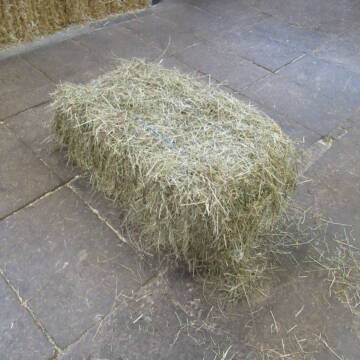
Heu Rundballen
Espenschied
Marvin Kloos
@Birkenhof_Espenschied
Heu
Rundballen
Bio
Regenfrei
Wird verladen
2 weitere...
B+
Deprecated: Creation of dynamic property Zend_View_Helper_Ads::$adLink is deprecated in /var/www/stall-frei/htdocs/staging.stall-frei.de/library/Psf/View/Helper/Ads.php on line 108

Heu und Heulage verkaufen
Mechtersen
STALL-FREIde Marketing
@STALL-FREI-Marketing
Verkaufen Sie Ihr Heu und Ihre Heulage direkt an Reiter, Pferdeställe und Reitanlagen
Leider kein Vorschaubild
Leider kein Vorschaubild
Heucobs zu verkaufen
Langenau
Bewegungsstall-Unseld
@Bewegungsstall-Unseld
Heu
Großballen
Regenfrei
Wird verladen
B+
Leider kein Vorschaubild
Leider kein Vorschaubild
Heucobs in Bigbags oder 25 kg Säcke
Langenau
Bewegungsstall-Unseld
@Bewegungsstall-Unseld
Futter
Pellets
Regenfrei
Wird verladen
1 weitere...
B+

Bedampftes Heu in Großballen für Allergikerpferd...
Langenau
Bewegungsstall-Unseld
@Bewegungsstall-Unseld
Heu
Großballen
Regenfrei
Wird verladen
1 weitere...
B+
Leider kein Vorschaubild
Leider kein Vorschaubild
heu 2025 heu 2ter schnitt 2025
Maisach
Reitstall Thurner
@ReitstallThurner
Heu
Empfänger lädt ab
Rundballen
Regenfrei
3 weitere...
B+


Heu, Heulage und Stroh in jeglichen Ballenformen
Hennef
Hof-Bongartz
@Hof-Bongartz
Heu
Lieferant entlädt
Großballen
Regenfrei
3 weitere...
P+

Persönlichkeitsentwicklung mit Pferden
Bad Salzuflen
Katja Dors
@Pferdezeiten
Begleite andere auf ihrem Entwicklungsweg und entdecke die transformative Kraft der pferdegestützten Persönlichkeitsentwicklung !
neu
R

Heu 1. und 2 Schnitt 2025 - Quaderballen
Nottuln
Ponypension am Draum
@Ponypension-am-Draum
Heu
Empfänger lädt ab
Großballen
Bio
Regenfrei
3 weitere...
B+

Hochwertiges Pferdeheu
Bochum
Heuhandel K + K GmbH
@HeuhandelKK
Heu
Lieferant entlädt
Großballen
Bio
Regenfrei
3 weitere...
B+

Heu, Bio Ökol, Kräuter, Pferd, Kreuzkraut frei
Rösrath
Konrad-Biohof-Gut-Breide-LAG
@BiohofGutBreideLAG
Heu
Empfänger lädt ab
Rundballen
Bio
Regenfrei
2 weitere...
B+
Werde Teil von STALL-FREI.de
Verkaufe Heu, Heulage, Stroh, Einstreu oder Futter an Pferdehalter und Stallbetreiber
Deprecated: Creation of dynamic property Zend_View::$pageCount is deprecated in /var/www/stall-frei/htdocs/staging.stall-frei.de/library/vendor/shardj/zf1-future/library/Zend/View/Abstract.php on line 308
Deprecated: Creation of dynamic property Zend_View::$itemCountPerPage is deprecated in /var/www/stall-frei/htdocs/staging.stall-frei.de/library/vendor/shardj/zf1-future/library/Zend/View/Abstract.php on line 308
Deprecated: Creation of dynamic property Zend_View::$first is deprecated in /var/www/stall-frei/htdocs/staging.stall-frei.de/library/vendor/shardj/zf1-future/library/Zend/View/Abstract.php on line 308
Deprecated: Creation of dynamic property Zend_View::$current is deprecated in /var/www/stall-frei/htdocs/staging.stall-frei.de/library/vendor/shardj/zf1-future/library/Zend/View/Abstract.php on line 308
Deprecated: Creation of dynamic property Zend_View::$last is deprecated in /var/www/stall-frei/htdocs/staging.stall-frei.de/library/vendor/shardj/zf1-future/library/Zend/View/Abstract.php on line 308
Deprecated: Creation of dynamic property Zend_View::$previous is deprecated in /var/www/stall-frei/htdocs/staging.stall-frei.de/library/vendor/shardj/zf1-future/library/Zend/View/Abstract.php on line 308
Deprecated: Creation of dynamic property Zend_View::$next is deprecated in /var/www/stall-frei/htdocs/staging.stall-frei.de/library/vendor/shardj/zf1-future/library/Zend/View/Abstract.php on line 308
Deprecated: Creation of dynamic property Zend_View::$pagesInRange is deprecated in /var/www/stall-frei/htdocs/staging.stall-frei.de/library/vendor/shardj/zf1-future/library/Zend/View/Abstract.php on line 308
Deprecated: Creation of dynamic property Zend_View::$firstPageInRange is deprecated in /var/www/stall-frei/htdocs/staging.stall-frei.de/library/vendor/shardj/zf1-future/library/Zend/View/Abstract.php on line 308
Deprecated: Creation of dynamic property Zend_View::$lastPageInRange is deprecated in /var/www/stall-frei/htdocs/staging.stall-frei.de/library/vendor/shardj/zf1-future/library/Zend/View/Abstract.php on line 308
Deprecated: Creation of dynamic property Zend_View::$currentItemCount is deprecated in /var/www/stall-frei/htdocs/staging.stall-frei.de/library/vendor/shardj/zf1-future/library/Zend/View/Abstract.php on line 308
Deprecated: Creation of dynamic property Zend_View::$totalItemCount is deprecated in /var/www/stall-frei/htdocs/staging.stall-frei.de/library/vendor/shardj/zf1-future/library/Zend/View/Abstract.php on line 308
Deprecated: Creation of dynamic property Zend_View::$firstItemNumber is deprecated in /var/www/stall-frei/htdocs/staging.stall-frei.de/library/vendor/shardj/zf1-future/library/Zend/View/Abstract.php on line 308
Deprecated: Creation of dynamic property Zend_View::$lastItemNumber is deprecated in /var/www/stall-frei/htdocs/staging.stall-frei.de/library/vendor/shardj/zf1-future/library/Zend/View/Abstract.php on line 308
Deprecated: Creation of dynamic property Zend_View::$router is deprecated in /var/www/stall-frei/htdocs/staging.stall-frei.de/library/vendor/shardj/zf1-future/library/Zend/View/Abstract.php on line 308
Deprecated: Creation of dynamic property Zend_View::$urlParams is deprecated in /var/www/stall-frei/htdocs/staging.stall-frei.de/library/vendor/shardj/zf1-future/library/Zend/View/Abstract.php on line 308
Deprecated: Creation of dynamic property Zend_View::$showAds is deprecated in /var/www/stall-frei/htdocs/staging.stall-frei.de/library/vendor/shardj/zf1-future/library/Zend/View/Abstract.php on line 308
Deprecated: Creation of dynamic property Zend_View::$objectIds is deprecated in /var/www/stall-frei/htdocs/staging.stall-frei.de/library/vendor/shardj/zf1-future/library/Zend/View/Abstract.php on line 308
Deprecated: Creation of dynamic property Zend_View::$showNavbar is deprecated in /var/www/stall-frei/htdocs/staging.stall-frei.de/library/vendor/shardj/zf1-future/library/Zend/View/Abstract.php on line 308
Deprecated: Creation of dynamic property Zend_View::$showBreadcrumb is deprecated in /var/www/stall-frei/htdocs/staging.stall-frei.de/library/vendor/shardj/zf1-future/library/Zend/View/Abstract.php on line 308
Deprecated: Creation of dynamic property Zend_View::$showFooter is deprecated in /var/www/stall-frei/htdocs/staging.stall-frei.de/library/vendor/shardj/zf1-future/library/Zend/View/Abstract.php on line 308
Deprecated: Creation of dynamic property Zend_View::$showInternalAds is deprecated in /var/www/stall-frei/htdocs/staging.stall-frei.de/library/vendor/shardj/zf1-future/library/Zend/View/Abstract.php on line 308
Deprecated: Creation of dynamic property Zend_View::$blNoContent is deprecated in /var/www/stall-frei/htdocs/staging.stall-frei.de/library/vendor/shardj/zf1-future/library/Zend/View/Abstract.php on line 308
Deprecated: Creation of dynamic property Zend_View::$sMetaDesc is deprecated in /var/www/stall-frei/htdocs/staging.stall-frei.de/library/vendor/shardj/zf1-future/library/Zend/View/Abstract.php on line 308
Deprecated: Creation of dynamic property Zend_View::$useGmaps is deprecated in /var/www/stall-frei/htdocs/staging.stall-frei.de/library/vendor/shardj/zf1-future/library/Zend/View/Abstract.php on line 308
Deprecated: Creation of dynamic property Zend_View::$touches is deprecated in /var/www/stall-frei/htdocs/staging.stall-frei.de/library/vendor/shardj/zf1-future/library/Zend/View/Abstract.php on line 308
Deprecated: Creation of dynamic property Zend_View::$oProject is deprecated in /var/www/stall-frei/htdocs/staging.stall-frei.de/library/vendor/shardj/zf1-future/library/Zend/View/Abstract.php on line 308
Deprecated: Creation of dynamic property Zend_View::$pageHeadline is deprecated in /var/www/stall-frei/htdocs/staging.stall-frei.de/library/vendor/shardj/zf1-future/library/Zend/View/Abstract.php on line 308
Deprecated: Creation of dynamic property Zend_View::$disableLocationField is deprecated in /var/www/stall-frei/htdocs/staging.stall-frei.de/library/vendor/shardj/zf1-future/library/Zend/View/Abstract.php on line 308
Deprecated: Creation of dynamic property Zend_View::$isSearch is deprecated in /var/www/stall-frei/htdocs/staging.stall-frei.de/library/vendor/shardj/zf1-future/library/Zend/View/Abstract.php on line 308
Deprecated: Creation of dynamic property Zend_View::$pageTitle is deprecated in /var/www/stall-frei/htdocs/staging.stall-frei.de/library/vendor/shardj/zf1-future/library/Zend/View/Abstract.php on line 308
Deprecated: Creation of dynamic property Psf_Form_Element_Text::$class is deprecated in /var/www/stall-frei/htdocs/staging.stall-frei.de/library/vendor/shardj/zf1-future/library/Zend/Form/Element.php on line 874
Deprecated: Creation of dynamic property Psf_Form_Element_Text::$size is deprecated in /var/www/stall-frei/htdocs/staging.stall-frei.de/library/vendor/shardj/zf1-future/library/Zend/Form/Element.php on line 874
Deprecated: Creation of dynamic property Psf_Form_Element_Text::$placeholder is deprecated in /var/www/stall-frei/htdocs/staging.stall-frei.de/library/vendor/shardj/zf1-future/library/Zend/Form/Element.php on line 874
Deprecated: Creation of dynamic property Psf_Form_Element_Hidden::$class is deprecated in /var/www/stall-frei/htdocs/staging.stall-frei.de/library/vendor/shardj/zf1-future/library/Zend/Form/Element.php on line 874
Deprecated: Creation of dynamic property Psf_Form_Element_Hidden::$class is deprecated in /var/www/stall-frei/htdocs/staging.stall-frei.de/library/vendor/shardj/zf1-future/library/Zend/Form/Element.php on line 874
Deprecated: Creation of dynamic property Psf_Form_Element_Hidden::$class is deprecated in /var/www/stall-frei/htdocs/staging.stall-frei.de/library/vendor/shardj/zf1-future/library/Zend/Form/Element.php on line 874
Deprecated: Creation of dynamic property Psf_Form_Element_Hidden::$class is deprecated in /var/www/stall-frei/htdocs/staging.stall-frei.de/library/vendor/shardj/zf1-future/library/Zend/Form/Element.php on line 874
Deprecated: Creation of dynamic property Psf_Form_Element_Select::$class is deprecated in /var/www/stall-frei/htdocs/staging.stall-frei.de/library/vendor/shardj/zf1-future/library/Zend/Form/Element.php on line 874
Deprecated: Creation of dynamic property Psf_Form_Element_Select::$class is deprecated in /var/www/stall-frei/htdocs/staging.stall-frei.de/library/vendor/shardj/zf1-future/library/Zend/Form/Element.php on line 874
Deprecated: Creation of dynamic property Psf_Form_Element_Select::$class is deprecated in /var/www/stall-frei/htdocs/staging.stall-frei.de/library/vendor/shardj/zf1-future/library/Zend/Form/Element.php on line 874
Deprecated: Creation of dynamic property Psf_Form_Element_Select::$class is deprecated in /var/www/stall-frei/htdocs/staging.stall-frei.de/library/vendor/shardj/zf1-future/library/Zend/Form/Element.php on line 874
Deprecated: Creation of dynamic property Zend_View::$sort is deprecated in /var/www/stall-frei/htdocs/staging.stall-frei.de/library/vendor/shardj/zf1-future/library/Zend/View/Abstract.php on line 308
Deprecated: Creation of dynamic property Zend_View::$searchLocation is deprecated in /var/www/stall-frei/htdocs/staging.stall-frei.de/library/vendor/shardj/zf1-future/library/Zend/View/Abstract.php on line 308
Deprecated: Creation of dynamic property Zend_View::$locationHint is deprecated in /var/www/stall-frei/htdocs/staging.stall-frei.de/library/vendor/shardj/zf1-future/library/Zend/View/Abstract.php on line 308
Psf_GeoCoder_Abstract::getLocation: Ostwald Get Location CachedOrLive
Psf_GeoCoder_Abstract::getCachedOrLive: Ostwald
Psf_GeoCoder_Abstract::convertLocationResult
{"documentation":"https:\/\/opencagedata.com\/api","licenses":[{"name":"see attribution guide","url":"https:\/\/opencagedata.com\/credits"}],"results":[{"bounds":{"northeast":{"lat":51.3008059,"lng":12.4042215},"southwest":{"lat":51.2998211,"lng":12.4013708}},"components":{"ISO_3166-1_alpha-2":"DE","ISO_3166-1_alpha-3":"DEU","ISO_3166-2":["DE-SN"],"_category":"education","_normalized_city":"Leipzig","_type":"school","city":"Leipzig","city_district":"S\u00fcd","continent":"Europe","country":"Deutschland","country_code":"de","house_number":"15","political_union":"European Union","postcode":"04279","road":"Willi-Bredel-Stra\u00dfe","school":"Wilhelm-Ostwald-Schule - Gymnasium der Stadt Leipzig","state":"Sachsen","state_code":"SN","suburb":"L\u00f6\u00dfnig"},"confidence":9,"formatted":"Wilhelm-Ostwald-Schule - Gymnasium der Stadt Leipzig, Willi-Bredel-Stra\u00dfe 15, 04279 Leipzig, Deutschland","geometry":{"lat":51.3004608,"lng":12.4030792}},{"bounds":{"northeast":{"lat":51.1927793,"lng":12.7444573},"southwest":{"lat":51.1898549,"lng":12.7401173}},"components":{"ISO_3166-1_alpha-2":"DE","ISO_3166-1_alpha-3":"DEU","ISO_3166-2":["DE-SN"],"_category":"outdoors\/recreation","_normalized_city":"Grimma","_type":"park","city_district":"Gro\u00dfbothen","continent":"Europe","country":"Deutschland","country_code":"de","county":"Landkreis Leipzig","park":"Wilhelm-Ostwald-Park","political_union":"European Union","postcode":"04668","state":"Sachsen","state_code":"SN","town":"Grimma"},"confidence":9,"formatted":"Wilhelm-Ostwald-Park, 04668 Grimma, Deutschland","geometry":{"lat":51.1914015,"lng":12.7421308}},{"bounds":{"northeast":{"lat":51.1908008,"lng":12.7576107},"southwest":{"lat":51.1901372,"lng":12.751745}},"components":{"ISO_3166-1_alpha-2":"DE","ISO_3166-1_alpha-3":"DEU","ISO_3166-2":["DE-SN"],"_category":"road","_normalized_city":"Grimma","_type":"road","city_district":"Gro\u00dfbothen","continent":"Europe","country":"Deutschland","country_code":"de","county":"Landkreis Leipzig","political_union":"European Union","postcode":"04668","road":"Wilhelm-Ostwald-Stra\u00dfe","road_type":"residential","state":"Sachsen","state_code":"SN","town":"Grimma"},"confidence":9,"formatted":"Wilhelm-Ostwald-Stra\u00dfe, 04668 Grimma, Deutschland","geometry":{"lat":51.1905419,"lng":12.7546826}},{"bounds":{"northeast":{"lat":51.1607426,"lng":12.9145169},"southwest":{"lat":51.1592245,"lng":12.9130355}},"components":{"ISO_3166-1_alpha-2":"DE","ISO_3166-1_alpha-3":"DEU","ISO_3166-2":["DE-SN"],"_category":"road","_normalized_city":"Leisnig","_type":"road","continent":"Europe","country":"Deutschland","country_code":"de","county":"Mittelsachsen","political_union":"European Union","postcode":"04703","road":"Wilhelm-Ostwald-Stra\u00dfe","road_type":"secondary","state":"Sachsen","state_code":"SN","suburb":"Fischendorf","town":"Leisnig"},"confidence":9,"formatted":"Wilhelm-Ostwald-Stra\u00dfe, 04703 Leisnig, Deutschland","geometry":{"lat":51.160062,"lng":12.9138609}},{"bounds":{"northeast":{"lat":52.4271077,"lng":13.542506},"southwest":{"lat":52.4265296,"lng":13.5414566}},"components":{"ISO_3166-1_alpha-2":"DE","ISO_3166-1_alpha-3":"DEU","ISO_3166-2":["DE-BE"],"_category":"road","_normalized_city":"Berlin","_type":"road","borough":"Treptow-K\u00f6penick","city":"Berlin","continent":"Europe","country":"Deutschland","country_code":"de","political_union":"European Union","postcode":"12489","quarter":"WISTA","road":"Wilhelm-Ostwald-Stra\u00dfe","road_type":"residential","state":"Berlin","state_code":"BE","suburb":"Adlershof"},"confidence":9,"formatted":"Wilhelm-Ostwald-Stra\u00dfe, 12489 Berlin, Deutschland","geometry":{"lat":52.4268183,"lng":13.5419815}},{"bounds":{"northeast":{"lat":52.5370554,"lng":13.0477858},"southwest":{"lat":52.537003,"lng":13.0443268}},"components":{"ISO_3166-1_alpha-2":"DE","ISO_3166-1_alpha-3":"DEU","ISO_3166-2":["DE-BB"],"_category":"road","_normalized_city":"Dallgow-D\u00f6beritz","_type":"road","continent":"Europe","country":"Deutschland","country_code":"de","county":"Havelland","hamlet":"Rohrbeck","neighbourhood":"Neu-D\u00f6beritz","political_union":"European Union","postcode":"14624","road":"Wilhelm-Ostwald-Stra\u00dfe","road_type":"living_street","state":"Brandenburg","state_code":"BB","village":"Dallgow-D\u00f6beritz"},"confidence":9,"formatted":"Wilhelm-Ostwald-Stra\u00dfe, 14624 Dallgow-D\u00f6beritz, Deutschland","geometry":{"lat":52.5370292,"lng":13.0460563}},{"bounds":{"northeast":{"lat":51.160104,"lng":9.5488033},"southwest":{"lat":51.1591888,"lng":9.5480434}},"components":{"ISO_3166-1_alpha-2":"DE","ISO_3166-1_alpha-3":"DEU","ISO_3166-2":["DE-HE"],"_category":"road","_normalized_city":"R\u00f6hrenfurth","_type":"road","continent":"Europe","country":"Deutschland","country_code":"de","county":"Schwalm-Eder-Kreis","municipality":"Melsungen","political_union":"European Union","postcode":"34212","road":"Ostwaldstra\u00dfe","road_type":"residential","state":"Hessen","state_code":"HE","village":"R\u00f6hrenfurth"},"confidence":9,"formatted":"Ostwaldstra\u00dfe, 34212 R\u00f6hrenfurth, Deutschland","geometry":{"lat":51.1596569,"lng":9.5484111}},{"bounds":{"northeast":{"lat":50.8124909,"lng":12.8189931},"southwest":{"lat":50.8123797,"lng":12.8182034}},"components":{"ISO_3166-1_alpha-2":"DE","ISO_3166-1_alpha-3":"DEU","ISO_3166-2":["DE-SN"],"_category":"road","_normalized_city":"Chemnitz","_type":"road","city":"Chemnitz","continent":"Europe","country":"Deutschland","country_code":"de","political_union":"European Union","postcode":"09117","road":"Ostwaldweg","road_type":"residential","state":"Sachsen","state_code":"SN","suburb":"Reichenbrand"},"confidence":9,"formatted":"Ostwaldweg, 09117 Chemnitz, Deutschland","geometry":{"lat":50.8123977,"lng":12.8185782}},{"components":{"ISO_3166-1_alpha-2":"FR","ISO_3166-1_alpha-3":"FRA","ISO_3166-2":["FR-GES","FR-6AE","FR-67"],"_category":"place","_normalized_city":"Strasbourg","_type":"place","city":"Strasbourg","continent":"Europe","country":"France","country_code":"fr","county":"Bas-Rhin","local_authority":"Strasbourg Eurom\u00e9tropole","place":"Place d'Ostwald","political_union":"European Union","postcode":"67200","state":"Grand Est","state_code":"GES"},"confidence":4,"formatted":"Place d'Ostwald, 67200 Strasbourg, France","geometry":{"lat":48.564308,"lng":7.70718}},{"components":{"ISO_3166-1_alpha-2":"FR","ISO_3166-1_alpha-3":"FRA","ISO_3166-2":["FR-GES","FR-6AE","FR-67"],"_category":"road","_normalized_city":"Ostwald","_type":"road","city":"Ostwald","continent":"Europe","country":"France","country_code":"fr","county":"Bas-Rhin","local_authority":"Strasbourg Eurom\u00e9tropole","political_union":"European Union","postcode":"67540","road":"Place d'Andlau","state":"Grand Est","state_code":"GES"},"confidence":4,"formatted":"Place d'Andlau, 67540 Ostwald, France","geometry":{"lat":48.537954,"lng":7.706948}}],"status":{"code":200,"message":"OK"},"stay_informed":{"blog":"https:\/\/blog.opencagedata.com","mastodon":"https:\/\/en.osm.town\/@opencage"},"thanks":"For using an OpenCage API","timestamp":{"created_http":"Sat, 07 Feb 2026 03:16:28 GMT","created_unix":1770434188},"total_results":10}Array
(
[0] => stdClass Object
(
[bounds] => stdClass Object
(
[northeast] => stdClass Object
(
[lat] => 51.3008059
[lng] => 12.4042215
)
[southwest] => stdClass Object
(
[lat] => 51.2998211
[lng] => 12.4013708
)
)
[components] => stdClass Object
(
[ISO_3166-1_alpha-2] => DE
[ISO_3166-1_alpha-3] => DEU
[ISO_3166-2] => Array
(
[0] => DE-SN
)
[_category] => education
[_normalized_city] => Leipzig
[_type] => school
[city] => Leipzig
[city_district] => Süd
[continent] => Europe
[country] => Deutschland
[country_code] => de
[house_number] => 15
[political_union] => European Union
[postcode] => 04279
[road] => Willi-Bredel-Straße
[school] => Wilhelm-Ostwald-Schule - Gymnasium der Stadt Leipzig
[state] => Sachsen
[state_code] => SN
[suburb] => Lößnig
)
[confidence] => 9
[formatted] => Wilhelm-Ostwald-Schule - Gymnasium der Stadt Leipzig, Willi-Bredel-Straße 15, 04279 Leipzig, Deutschland
[geometry] => stdClass Object
(
[lat] => 51.3004608
[lng] => 12.4030792
)
)
[1] => stdClass Object
(
[bounds] => stdClass Object
(
[northeast] => stdClass Object
(
[lat] => 51.1927793
[lng] => 12.7444573
)
[southwest] => stdClass Object
(
[lat] => 51.1898549
[lng] => 12.7401173
)
)
[components] => stdClass Object
(
[ISO_3166-1_alpha-2] => DE
[ISO_3166-1_alpha-3] => DEU
[ISO_3166-2] => Array
(
[0] => DE-SN
)
[_category] => outdoors/recreation
[_normalized_city] => Grimma
[_type] => park
[city_district] => Großbothen
[continent] => Europe
[country] => Deutschland
[country_code] => de
[county] => Landkreis Leipzig
[park] => Wilhelm-Ostwald-Park
[political_union] => European Union
[postcode] => 04668
[state] => Sachsen
[state_code] => SN
[town] => Grimma
)
[confidence] => 9
[formatted] => Wilhelm-Ostwald-Park, 04668 Grimma, Deutschland
[geometry] => stdClass Object
(
[lat] => 51.1914015
[lng] => 12.7421308
)
)
[2] => stdClass Object
(
[bounds] => stdClass Object
(
[northeast] => stdClass Object
(
[lat] => 51.1908008
[lng] => 12.7576107
)
[southwest] => stdClass Object
(
[lat] => 51.1901372
[lng] => 12.751745
)
)
[components] => stdClass Object
(
[ISO_3166-1_alpha-2] => DE
[ISO_3166-1_alpha-3] => DEU
[ISO_3166-2] => Array
(
[0] => DE-SN
)
[_category] => road
[_normalized_city] => Grimma
[_type] => road
[city_district] => Großbothen
[continent] => Europe
[country] => Deutschland
[country_code] => de
[county] => Landkreis Leipzig
[political_union] => European Union
[postcode] => 04668
[road] => Wilhelm-Ostwald-Straße
[road_type] => residential
[state] => Sachsen
[state_code] => SN
[town] => Grimma
)
[confidence] => 9
[formatted] => Wilhelm-Ostwald-Straße, 04668 Grimma, Deutschland
[geometry] => stdClass Object
(
[lat] => 51.1905419
[lng] => 12.7546826
)
)
[3] => stdClass Object
(
[bounds] => stdClass Object
(
[northeast] => stdClass Object
(
[lat] => 51.1607426
[lng] => 12.9145169
)
[southwest] => stdClass Object
(
[lat] => 51.1592245
[lng] => 12.9130355
)
)
[components] => stdClass Object
(
[ISO_3166-1_alpha-2] => DE
[ISO_3166-1_alpha-3] => DEU
[ISO_3166-2] => Array
(
[0] => DE-SN
)
[_category] => road
[_normalized_city] => Leisnig
[_type] => road
[continent] => Europe
[country] => Deutschland
[country_code] => de
[county] => Mittelsachsen
[political_union] => European Union
[postcode] => 04703
[road] => Wilhelm-Ostwald-Straße
[road_type] => secondary
[state] => Sachsen
[state_code] => SN
[suburb] => Fischendorf
[town] => Leisnig
)
[confidence] => 9
[formatted] => Wilhelm-Ostwald-Straße, 04703 Leisnig, Deutschland
[geometry] => stdClass Object
(
[lat] => 51.160062
[lng] => 12.9138609
)
)
[4] => stdClass Object
(
[bounds] => stdClass Object
(
[northeast] => stdClass Object
(
[lat] => 52.4271077
[lng] => 13.542506
)
[southwest] => stdClass Object
(
[lat] => 52.4265296
[lng] => 13.5414566
)
)
[components] => stdClass Object
(
[ISO_3166-1_alpha-2] => DE
[ISO_3166-1_alpha-3] => DEU
[ISO_3166-2] => Array
(
[0] => DE-BE
)
[_category] => road
[_normalized_city] => Berlin
[_type] => road
[borough] => Treptow-Köpenick
[city] => Berlin
[continent] => Europe
[country] => Deutschland
[country_code] => de
[political_union] => European Union
[postcode] => 12489
[quarter] => WISTA
[road] => Wilhelm-Ostwald-Straße
[road_type] => residential
[state] => Berlin
[state_code] => BE
[suburb] => Adlershof
)
[confidence] => 9
[formatted] => Wilhelm-Ostwald-Straße, 12489 Berlin, Deutschland
[geometry] => stdClass Object
(
[lat] => 52.4268183
[lng] => 13.5419815
)
)
[5] => stdClass Object
(
[bounds] => stdClass Object
(
[northeast] => stdClass Object
(
[lat] => 52.5370554
[lng] => 13.0477858
)
[southwest] => stdClass Object
(
[lat] => 52.537003
[lng] => 13.0443268
)
)
[components] => stdClass Object
(
[ISO_3166-1_alpha-2] => DE
[ISO_3166-1_alpha-3] => DEU
[ISO_3166-2] => Array
(
[0] => DE-BB
)
[_category] => road
[_normalized_city] => Dallgow-Döberitz
[_type] => road
[continent] => Europe
[country] => Deutschland
[country_code] => de
[county] => Havelland
[hamlet] => Rohrbeck
[neighbourhood] => Neu-Döberitz
[political_union] => European Union
[postcode] => 14624
[road] => Wilhelm-Ostwald-Straße
[road_type] => living_street
[state] => Brandenburg
[state_code] => BB
[village] => Dallgow-Döberitz
)
[confidence] => 9
[formatted] => Wilhelm-Ostwald-Straße, 14624 Dallgow-Döberitz, Deutschland
[geometry] => stdClass Object
(
[lat] => 52.5370292
[lng] => 13.0460563
)
)
[6] => stdClass Object
(
[bounds] => stdClass Object
(
[northeast] => stdClass Object
(
[lat] => 51.160104
[lng] => 9.5488033
)
[southwest] => stdClass Object
(
[lat] => 51.1591888
[lng] => 9.5480434
)
)
[components] => stdClass Object
(
[ISO_3166-1_alpha-2] => DE
[ISO_3166-1_alpha-3] => DEU
[ISO_3166-2] => Array
(
[0] => DE-HE
)
[_category] => road
[_normalized_city] => Röhrenfurth
[_type] => road
[continent] => Europe
[country] => Deutschland
[country_code] => de
[county] => Schwalm-Eder-Kreis
[municipality] => Melsungen
[political_union] => European Union
[postcode] => 34212
[road] => Ostwaldstraße
[road_type] => residential
[state] => Hessen
[state_code] => HE
[village] => Röhrenfurth
)
[confidence] => 9
[formatted] => Ostwaldstraße, 34212 Röhrenfurth, Deutschland
[geometry] => stdClass Object
(
[lat] => 51.1596569
[lng] => 9.5484111
)
)
[7] => stdClass Object
(
[bounds] => stdClass Object
(
[northeast] => stdClass Object
(
[lat] => 50.8124909
[lng] => 12.8189931
)
[southwest] => stdClass Object
(
[lat] => 50.8123797
[lng] => 12.8182034
)
)
[components] => stdClass Object
(
[ISO_3166-1_alpha-2] => DE
[ISO_3166-1_alpha-3] => DEU
[ISO_3166-2] => Array
(
[0] => DE-SN
)
[_category] => road
[_normalized_city] => Chemnitz
[_type] => road
[city] => Chemnitz
[continent] => Europe
[country] => Deutschland
[country_code] => de
[political_union] => European Union
[postcode] => 09117
[road] => Ostwaldweg
[road_type] => residential
[state] => Sachsen
[state_code] => SN
[suburb] => Reichenbrand
)
[confidence] => 9
[formatted] => Ostwaldweg, 09117 Chemnitz, Deutschland
[geometry] => stdClass Object
(
[lat] => 50.8123977
[lng] => 12.8185782
)
)
[8] => stdClass Object
(
[components] => stdClass Object
(
[ISO_3166-1_alpha-2] => FR
[ISO_3166-1_alpha-3] => FRA
[ISO_3166-2] => Array
(
[0] => FR-GES
[1] => FR-6AE
[2] => FR-67
)
[_category] => place
[_normalized_city] => Strasbourg
[_type] => place
[city] => Strasbourg
[continent] => Europe
[country] => France
[country_code] => fr
[county] => Bas-Rhin
[local_authority] => Strasbourg Eurométropole
[place] => Place d'Ostwald
[political_union] => European Union
[postcode] => 67200
[state] => Grand Est
[state_code] => GES
)
[confidence] => 4
[formatted] => Place d'Ostwald, 67200 Strasbourg, France
[geometry] => stdClass Object
(
[lat] => 48.564308
[lng] => 7.70718
)
)
[9] => stdClass Object
(
[components] => stdClass Object
(
[ISO_3166-1_alpha-2] => FR
[ISO_3166-1_alpha-3] => FRA
[ISO_3166-2] => Array
(
[0] => FR-GES
[1] => FR-6AE
[2] => FR-67
)
[_category] => road
[_normalized_city] => Ostwald
[_type] => road
[city] => Ostwald
[continent] => Europe
[country] => France
[country_code] => fr
[county] => Bas-Rhin
[local_authority] => Strasbourg Eurométropole
[political_union] => European Union
[postcode] => 67540
[road] => Place d'Andlau
[state] => Grand Est
[state_code] => GES
)
[confidence] => 4
[formatted] => Place d'Andlau, 67540 Ostwald, France
[geometry] => stdClass Object
(
[lat] => 48.537954
[lng] => 7.706948
)
)
)
Psf_GeoCoder_OpenCageData::getKeyMap: 0
stdClass Object
(
    [bounds] => stdClass Object
        (
            [northeast] => stdClass Object
                (
                    [lat] => 51.3008059
                    [lng] => 12.4042215
                )

            [southwest] => stdClass Object
                (
                    [lat] => 51.2998211
                    [lng] => 12.4013708
                )

        )

    [components] => stdClass Object
        (
            [ISO_3166-1_alpha-2] => DE
            [ISO_3166-1_alpha-3] => DEU
            [ISO_3166-2] => Array
                (
                    [0] => DE-SN
                )

            [_category] => education
            [_normalized_city] => Leipzig
            [_type] => school
            [city] => Leipzig
            [city_district] => Süd
            [continent] => Europe
            [country] => Deutschland
            [country_code] => de
            [house_number] => 15
            [political_union] => European Union
            [postcode] => 04279
            [road] => Willi-Bredel-Straße
            [school] => Wilhelm-Ostwald-Schule - Gymnasium der Stadt Leipzig
            [state] => Sachsen
            [state_code] => SN
            [suburb] => Lößnig
        )

    [confidence] => 9
    [formatted] => Wilhelm-Ostwald-Schule - Gymnasium der Stadt Leipzig, Willi-Bredel-Straße 15, 04279 Leipzig, Deutschland
    [geometry] => stdClass Object
        (
            [lat] => 51.3004608
            [lng] => 12.4030792
        )

)
Psf_GeoCoder_OpenCageData::getCounty: Leipzig
Psf_GeoCoder_OpenCageData::addMissingData REFETCH!
Array
(
    [address] => Wilhelm-Ostwald-Schule - Gymnasium der Stadt Leipzig, Willi-Bredel-Straße 15, 04279 Leipzig, Deutschland
    [type] => school
    [street] => Willi-Bredel-Straße 15
    [city] => Lößnig
    [county] => Leipzig
    [state] => Sachsen
    [zip] => 04279
    [country] => Deutschland
    [suburb] => Lößnig
    [countrycode] => de
    [latitude] => 51.3004608
    [longitude] => 12.4030792
    [accuracy] => 1
    [confidence] => 9
    [bounds] => stdClass Object
        (
            [northeast] => stdClass Object
                (
                    [lat] => 51.3008059
                    [lng] => 12.4042215
                )

            [southwest] => stdClass Object
                (
                    [lat] => 51.2998211
                    [lng] => 12.4013708
                )

        )

)
reformat!
Array
(
    [address] => Willi-Bredel-Straße 15, 04279 Lößnig
    [type] => school
    [street] => Willi-Bredel-Straße 15
    [city] => Lößnig
    [county] => Leipzig
    [state] => Sachsen
    [zip] => 04279
    [country] => Deutschland
    [suburb] => Lößnig
    [countrycode] => de
    [latitude] => 51.3004608
    [longitude] => 12.4030792
    [accuracy] => 1
    [confidence] => 9
    [bounds] => stdClass Object
        (
            [northeast] => stdClass Object
                (
                    [lat] => 51.3008059
                    [lng] => 12.4042215
                )

            [southwest] => stdClass Object
                (
                    [lat] => 51.2998211
                    [lng] => 12.4013708
                )

        )

    [place] => Willi-Bredel-Straße 15, 04279 Lößnig, Sachsen
    [hash] => 0d4d6d217348bb3db68db58b35b83c82
)
Psf_GeoCoder_OpenCageData::getKeyMap: 1
stdClass Object
(
    [bounds] => stdClass Object
        (
            [northeast] => stdClass Object
                (
                    [lat] => 51.1927793
                    [lng] => 12.7444573
                )

            [southwest] => stdClass Object
                (
                    [lat] => 51.1898549
                    [lng] => 12.7401173
                )

        )

    [components] => stdClass Object
        (
            [ISO_3166-1_alpha-2] => DE
            [ISO_3166-1_alpha-3] => DEU
            [ISO_3166-2] => Array
                (
                    [0] => DE-SN
                )

            [_category] => outdoors/recreation
            [_normalized_city] => Grimma
            [_type] => park
            [city_district] => Großbothen
            [continent] => Europe
            [country] => Deutschland
            [country_code] => de
            [county] => Landkreis Leipzig
            [park] => Wilhelm-Ostwald-Park
            [political_union] => European Union
            [postcode] => 04668
            [state] => Sachsen
            [state_code] => SN
            [town] => Grimma
        )

    [confidence] => 9
    [formatted] => Wilhelm-Ostwald-Park, 04668 Grimma, Deutschland
    [geometry] => stdClass Object
        (
            [lat] => 51.1914015
            [lng] => 12.7421308
        )

)
Psf_GeoCoder_OpenCageData::getCounty: Leipzig
Psf_GeoCoder_OpenCageData::addMissingData REFETCH!
Array
(
    [address] => Wilhelm-Ostwald-Park, 04668 Grimma, Deutschland
    [type] => park
    [street] =>
    [city] => Grimma
    [county] => Leipzig
    [state] => Sachsen
    [zip] => 04668
    [country] => Deutschland
    [suburb] =>
    [countrycode] => de
    [latitude] => 51.1914015
    [longitude] => 12.7421308
    [accuracy] => 1
    [confidence] => 9
    [bounds] => stdClass Object
        (
            [northeast] => stdClass Object
                (
                    [lat] => 51.1927793
                    [lng] => 12.7444573
                )

            [southwest] => stdClass Object
                (
                    [lat] => 51.1898549
                    [lng] => 12.7401173
                )

        )

)
reformat!
Array
(
    [address] => Wilhelm-Ostwald-Park, 04668 Grimma, Deutschland
    [type] => park
    [street] =>
    [city] => Grimma
    [county] => Leipzig
    [state] => Sachsen
    [zip] => 04668
    [country] => Deutschland
    [suburb] =>
    [countrycode] => de
    [latitude] => 51.1914015
    [longitude] => 12.7421308
    [accuracy] => 1
    [confidence] => 9
    [bounds] => stdClass Object
        (
            [northeast] => stdClass Object
                (
                    [lat] => 51.1927793
                    [lng] => 12.7444573
                )

            [southwest] => stdClass Object
                (
                    [lat] => 51.1898549
                    [lng] => 12.7401173
                )

        )

    [place] => 04668 Grimma, Sachsen
    [hash] => b280c7514efd3c81dbe1750baf2cba1c
)
Psf_GeoCoder_OpenCageData::getKeyMap: 2
stdClass Object
(
    [bounds] => stdClass Object
        (
            [northeast] => stdClass Object
                (
                    [lat] => 51.1908008
                    [lng] => 12.7576107
                )

            [southwest] => stdClass Object
                (
                    [lat] => 51.1901372
                    [lng] => 12.751745
                )

        )

    [components] => stdClass Object
        (
            [ISO_3166-1_alpha-2] => DE
            [ISO_3166-1_alpha-3] => DEU
            [ISO_3166-2] => Array
                (
                    [0] => DE-SN
                )

            [_category] => road
            [_normalized_city] => Grimma
            [_type] => road
            [city_district] => Großbothen
            [continent] => Europe
            [country] => Deutschland
            [country_code] => de
            [county] => Landkreis Leipzig
            [political_union] => European Union
            [postcode] => 04668
            [road] => Wilhelm-Ostwald-Straße
            [road_type] => residential
            [state] => Sachsen
            [state_code] => SN
            [town] => Grimma
        )

    [confidence] => 9
    [formatted] => Wilhelm-Ostwald-Straße, 04668 Grimma, Deutschland
    [geometry] => stdClass Object
        (
            [lat] => 51.1905419
            [lng] => 12.7546826
        )

)
Psf_GeoCoder_OpenCageData::getCounty: Leipzig
Psf_GeoCoder_OpenCageData::addMissingData REFETCH!
Array
(
    [address] => Wilhelm-Ostwald-Straße, 04668 Grimma, Deutschland
    [type] => road
    [street] => Wilhelm-Ostwald-Straße
    [city] => Grimma
    [county] => Leipzig
    [state] => Sachsen
    [zip] => 04668
    [country] => Deutschland
    [suburb] =>
    [countrycode] => de
    [latitude] => 51.1905419
    [longitude] => 12.7546826
    [accuracy] => 1
    [confidence] => 9
    [bounds] => stdClass Object
        (
            [northeast] => stdClass Object
                (
                    [lat] => 51.1908008
                    [lng] => 12.7576107
                )

            [southwest] => stdClass Object
                (
                    [lat] => 51.1901372
                    [lng] => 12.751745
                )

        )

)
reformat!
Array
(
    [address] => Wilhelm-Ostwald-Straße, 04668 Grimma, Deutschland
    [type] => road
    [street] => Wilhelm-Ostwald-Straße
    [city] => Grimma
    [county] => Leipzig
    [state] => Sachsen
    [zip] => 04668
    [country] => Deutschland
    [suburb] =>
    [countrycode] => de
    [latitude] => 51.1905419
    [longitude] => 12.7546826
    [accuracy] => 1
    [confidence] => 9
    [bounds] => stdClass Object
        (
            [northeast] => stdClass Object
                (
                    [lat] => 51.1908008
                    [lng] => 12.7576107
                )

            [southwest] => stdClass Object
                (
                    [lat] => 51.1901372
                    [lng] => 12.751745
                )

        )

    [place] => Wilhelm-Ostwald-Straße, 04668 Grimma, Sachsen
    [hash] => 80d64457cbcf996ac18f08144825c4ab
)
Psf_GeoCoder_OpenCageData::getKeyMap: 3
stdClass Object
(
    [bounds] => stdClass Object
        (
            [northeast] => stdClass Object
                (
                    [lat] => 51.1607426
                    [lng] => 12.9145169
                )

            [southwest] => stdClass Object
                (
                    [lat] => 51.1592245
                    [lng] => 12.9130355
                )

        )

    [components] => stdClass Object
        (
            [ISO_3166-1_alpha-2] => DE
            [ISO_3166-1_alpha-3] => DEU
            [ISO_3166-2] => Array
                (
                    [0] => DE-SN
                )

            [_category] => road
            [_normalized_city] => Leisnig
            [_type] => road
            [continent] => Europe
            [country] => Deutschland
            [country_code] => de
            [county] => Mittelsachsen
            [political_union] => European Union
            [postcode] => 04703
            [road] => Wilhelm-Ostwald-Straße
            [road_type] => secondary
            [state] => Sachsen
            [state_code] => SN
            [suburb] => Fischendorf
            [town] => Leisnig
        )

    [confidence] => 9
    [formatted] => Wilhelm-Ostwald-Straße, 04703 Leisnig, Deutschland
    [geometry] => stdClass Object
        (
            [lat] => 51.160062
            [lng] => 12.9138609
        )

)
Psf_GeoCoder_OpenCageData::getCounty: Mittelsachsen
Psf_GeoCoder_OpenCageData::addMissingData REFETCH!
Array
(
    [address] => Wilhelm-Ostwald-Straße, 04703 Leisnig, Deutschland
    [type] => road
    [street] => Wilhelm-Ostwald-Straße
    [city] => Leisnig
    [county] => Mittelsachsen
    [state] => Sachsen
    [zip] => 04703
    [country] => Deutschland
    [suburb] => Fischendorf
    [countrycode] => de
    [latitude] => 51.160062
    [longitude] => 12.9138609
    [accuracy] => 1
    [confidence] => 9
    [bounds] => stdClass Object
        (
            [northeast] => stdClass Object
                (
                    [lat] => 51.1607426
                    [lng] => 12.9145169
                )

            [southwest] => stdClass Object
                (
                    [lat] => 51.1592245
                    [lng] => 12.9130355
                )

        )

)
reformat!
Array
(
    [address] => Wilhelm-Ostwald-Straße, 04703 Leisnig, Deutschland
    [type] => road
    [street] => Wilhelm-Ostwald-Straße
    [city] => Leisnig
    [county] => Mittelsachsen
    [state] => Sachsen
    [zip] => 04703
    [country] => Deutschland
    [suburb] => Fischendorf
    [countrycode] => de
    [latitude] => 51.160062
    [longitude] => 12.9138609
    [accuracy] => 1
    [confidence] => 9
    [bounds] => stdClass Object
        (
            [northeast] => stdClass Object
                (
                    [lat] => 51.1607426
                    [lng] => 12.9145169
                )

            [southwest] => stdClass Object
                (
                    [lat] => 51.1592245
                    [lng] => 12.9130355
                )

        )

    [place] => Wilhelm-Ostwald-Straße, 04703 Leisnig, Sachsen
    [hash] => 1a4a0de2ab9b79eba635a7deb28164de
)
Psf_GeoCoder_OpenCageData::getKeyMap: 4
stdClass Object
(
    [bounds] => stdClass Object
        (
            [northeast] => stdClass Object
                (
                    [lat] => 52.4271077
                    [lng] => 13.542506
                )

            [southwest] => stdClass Object
                (
                    [lat] => 52.4265296
                    [lng] => 13.5414566
                )

        )

    [components] => stdClass Object
        (
            [ISO_3166-1_alpha-2] => DE
            [ISO_3166-1_alpha-3] => DEU
            [ISO_3166-2] => Array
                (
                    [0] => DE-BE
                )

            [_category] => road
            [_normalized_city] => Berlin
            [_type] => road
            [borough] => Treptow-Köpenick
            [city] => Berlin
            [continent] => Europe
            [country] => Deutschland
            [country_code] => de
            [political_union] => European Union
            [postcode] => 12489
            [quarter] => WISTA
            [road] => Wilhelm-Ostwald-Straße
            [road_type] => residential
            [state] => Berlin
            [state_code] => BE
            [suburb] => Adlershof
        )

    [confidence] => 9
    [formatted] => Wilhelm-Ostwald-Straße, 12489 Berlin, Deutschland
    [geometry] => stdClass Object
        (
            [lat] => 52.4268183
            [lng] => 13.5419815
        )

)
Psf_GeoCoder_OpenCageData::getCounty: Berlin
Psf_GeoCoder_OpenCageData::addMissingData REFETCH!
Array
(
    [address] => Wilhelm-Ostwald-Straße, 12489 Berlin, Deutschland
    [type] => road
    [street] => Wilhelm-Ostwald-Straße
    [city] => Adlershof
    [county] => Berlin
    [state] => Berlin
    [zip] => 12489
    [country] => Deutschland
    [suburb] => Adlershof
    [countrycode] => de
    [latitude] => 52.4268183
    [longitude] => 13.5419815
    [accuracy] => 1
    [confidence] => 9
    [bounds] => stdClass Object
        (
            [northeast] => stdClass Object
                (
                    [lat] => 52.4271077
                    [lng] => 13.542506
                )

            [southwest] => stdClass Object
                (
                    [lat] => 52.4265296
                    [lng] => 13.5414566
                )

        )

)
reformat!
Array
(
    [address] => Wilhelm-Ostwald-Straße, 12489 Adlershof
    [type] => road
    [street] => Wilhelm-Ostwald-Straße
    [city] => Adlershof
    [county] => Berlin
    [state] => Berlin
    [zip] => 12489
    [country] => Deutschland
    [suburb] => Adlershof
    [countrycode] => de
    [latitude] => 52.4268183
    [longitude] => 13.5419815
    [accuracy] => 1
    [confidence] => 9
    [bounds] => stdClass Object
        (
            [northeast] => stdClass Object
                (
                    [lat] => 52.4271077
                    [lng] => 13.542506
                )

            [southwest] => stdClass Object
                (
                    [lat] => 52.4265296
                    [lng] => 13.5414566
                )

        )

    [place] => Wilhelm-Ostwald-Straße, 12489 Adlershof, Berlin
    [hash] => 0e9147c253d9befe454cd32a273e45d1
)
Psf_GeoCoder_OpenCageData::getKeyMap: 5
stdClass Object
(
    [bounds] => stdClass Object
        (
            [northeast] => stdClass Object
                (
                    [lat] => 52.5370554
                    [lng] => 13.0477858
                )

            [southwest] => stdClass Object
                (
                    [lat] => 52.537003
                    [lng] => 13.0443268
                )

        )

    [components] => stdClass Object
        (
            [ISO_3166-1_alpha-2] => DE
            [ISO_3166-1_alpha-3] => DEU
            [ISO_3166-2] => Array
                (
                    [0] => DE-BB
                )

            [_category] => road
            [_normalized_city] => Dallgow-Döberitz
            [_type] => road
            [continent] => Europe
            [country] => Deutschland
            [country_code] => de
            [county] => Havelland
            [hamlet] => Rohrbeck
            [neighbourhood] => Neu-Döberitz
            [political_union] => European Union
            [postcode] => 14624
            [road] => Wilhelm-Ostwald-Straße
            [road_type] => living_street
            [state] => Brandenburg
            [state_code] => BB
            [village] => Dallgow-Döberitz
        )

    [confidence] => 9
    [formatted] => Wilhelm-Ostwald-Straße, 14624 Dallgow-Döberitz, Deutschland
    [geometry] => stdClass Object
        (
            [lat] => 52.5370292
            [lng] => 13.0460563
        )

)
Psf_GeoCoder_OpenCageData::getCounty: Havelland
Psf_GeoCoder_OpenCageData::addMissingData REFETCH!
Array
(
    [address] => Wilhelm-Ostwald-Straße, 14624 Dallgow-Döberitz, Deutschland
    [type] => road
    [street] => Wilhelm-Ostwald-Straße
    [city] => Dallgow-Döberitz
    [county] => Havelland
    [state] => Brandenburg
    [zip] => 14624
    [country] => Deutschland
    [suburb] =>
    [countrycode] => de
    [latitude] => 52.5370292
    [longitude] => 13.0460563
    [accuracy] => 1
    [confidence] => 9
    [bounds] => stdClass Object
        (
            [northeast] => stdClass Object
                (
                    [lat] => 52.5370554
                    [lng] => 13.0477858
                )

            [southwest] => stdClass Object
                (
                    [lat] => 52.537003
                    [lng] => 13.0443268
                )

        )

)
reformat!
Array
(
    [address] => Wilhelm-Ostwald-Straße, 14624 Dallgow-Döberitz, Deutschland
    [type] => road
    [street] => Wilhelm-Ostwald-Straße
    [city] => Dallgow-Döberitz
    [county] => Havelland
    [state] => Brandenburg
    [zip] => 14624
    [country] => Deutschland
    [suburb] =>
    [countrycode] => de
    [latitude] => 52.5370292
    [longitude] => 13.0460563
    [accuracy] => 1
    [confidence] => 9
    [bounds] => stdClass Object
        (
            [northeast] => stdClass Object
                (
                    [lat] => 52.5370554
                    [lng] => 13.0477858
                )

            [southwest] => stdClass Object
                (
                    [lat] => 52.537003
                    [lng] => 13.0443268
                )

        )

    [place] => Wilhelm-Ostwald-Straße, 14624 Dallgow-Döberitz, Brandenburg
    [hash] => 2cf845d94a857a9dcd03a5a462437383
)
Psf_GeoCoder_OpenCageData::getKeyMap: 6
stdClass Object
(
    [bounds] => stdClass Object
        (
            [northeast] => stdClass Object
                (
                    [lat] => 51.160104
                    [lng] => 9.5488033
                )

            [southwest] => stdClass Object
                (
                    [lat] => 51.1591888
                    [lng] => 9.5480434
                )

        )

    [components] => stdClass Object
        (
            [ISO_3166-1_alpha-2] => DE
            [ISO_3166-1_alpha-3] => DEU
            [ISO_3166-2] => Array
                (
                    [0] => DE-HE
                )

            [_category] => road
            [_normalized_city] => Röhrenfurth
            [_type] => road
            [continent] => Europe
            [country] => Deutschland
            [country_code] => de
            [county] => Schwalm-Eder-Kreis
            [municipality] => Melsungen
            [political_union] => European Union
            [postcode] => 34212
            [road] => Ostwaldstraße
            [road_type] => residential
            [state] => Hessen
            [state_code] => HE
            [village] => Röhrenfurth
        )

    [confidence] => 9
    [formatted] => Ostwaldstraße, 34212 Röhrenfurth, Deutschland
    [geometry] => stdClass Object
        (
            [lat] => 51.1596569
            [lng] => 9.5484111
        )

)
Psf_GeoCoder_OpenCageData::getCounty: Schwalm-Eder-Kreis
Psf_GeoCoder_OpenCageData::addMissingData REFETCH!
Array
(
    [address] => Ostwaldstraße, 34212 Röhrenfurth, Deutschland
    [type] => road
    [street] => Ostwaldstraße
    [city] => Röhrenfurth
    [county] => Schwalm-Eder-Kreis
    [state] => Hessen
    [zip] => 34212
    [country] => Deutschland
    [suburb] =>
    [countrycode] => de
    [latitude] => 51.1596569
    [longitude] => 9.5484111
    [accuracy] => 1
    [confidence] => 9
    [bounds] => stdClass Object
        (
            [northeast] => stdClass Object
                (
                    [lat] => 51.160104
                    [lng] => 9.5488033
                )

            [southwest] => stdClass Object
                (
                    [lat] => 51.1591888
                    [lng] => 9.5480434
                )

        )

)
reformat!
Array
(
    [address] => Ostwaldstraße, 34212 Röhrenfurth, Deutschland
    [type] => road
    [street] => Ostwaldstraße
    [city] => Röhrenfurth
    [county] => Schwalm-Eder-Kreis
    [state] => Hessen
    [zip] => 34212
    [country] => Deutschland
    [suburb] =>
    [countrycode] => de
    [latitude] => 51.1596569
    [longitude] => 9.5484111
    [accuracy] => 1
    [confidence] => 9
    [bounds] => stdClass Object
        (
            [northeast] => stdClass Object
                (
                    [lat] => 51.160104
                    [lng] => 9.5488033
                )

            [southwest] => stdClass Object
                (
                    [lat] => 51.1591888
                    [lng] => 9.5480434
                )

        )

    [place] => Ostwaldstraße, 34212 Röhrenfurth, Hessen
    [hash] => 18c833ee50b720efa128b0024adc51a9
)
Psf_GeoCoder_OpenCageData::getKeyMap: 7
stdClass Object
(
    [bounds] => stdClass Object
        (
            [northeast] => stdClass Object
                (
                    [lat] => 50.8124909
                    [lng] => 12.8189931
                )

            [southwest] => stdClass Object
                (
                    [lat] => 50.8123797
                    [lng] => 12.8182034
                )

        )

    [components] => stdClass Object
        (
            [ISO_3166-1_alpha-2] => DE
            [ISO_3166-1_alpha-3] => DEU
            [ISO_3166-2] => Array
                (
                    [0] => DE-SN
                )

            [_category] => road
            [_normalized_city] => Chemnitz
            [_type] => road
            [city] => Chemnitz
            [continent] => Europe
            [country] => Deutschland
            [country_code] => de
            [political_union] => European Union
            [postcode] => 09117
            [road] => Ostwaldweg
            [road_type] => residential
            [state] => Sachsen
            [state_code] => SN
            [suburb] => Reichenbrand
        )

    [confidence] => 9
    [formatted] => Ostwaldweg, 09117 Chemnitz, Deutschland
    [geometry] => stdClass Object
        (
            [lat] => 50.8123977
            [lng] => 12.8185782
        )

)
Psf_GeoCoder_OpenCageData::getCounty: Chemnitz
Psf_GeoCoder_OpenCageData::addMissingData REFETCH!
Array
(
    [address] => Ostwaldweg, 09117 Chemnitz, Deutschland
    [type] => road
    [street] => Ostwaldweg
    [city] => Reichenbrand
    [county] => Chemnitz
    [state] => Sachsen
    [zip] => 09117
    [country] => Deutschland
    [suburb] => Reichenbrand
    [countrycode] => de
    [latitude] => 50.8123977
    [longitude] => 12.8185782
    [accuracy] => 1
    [confidence] => 9
    [bounds] => stdClass Object
        (
            [northeast] => stdClass Object
                (
                    [lat] => 50.8124909
                    [lng] => 12.8189931
                )

            [southwest] => stdClass Object
                (
                    [lat] => 50.8123797
                    [lng] => 12.8182034
                )

        )

)
reformat!
Array
(
    [address] => Ostwaldweg, 09117 Reichenbrand
    [type] => road
    [street] => Ostwaldweg
    [city] => Reichenbrand
    [county] => Chemnitz
    [state] => Sachsen
    [zip] => 09117
    [country] => Deutschland
    [suburb] => Reichenbrand
    [countrycode] => de
    [latitude] => 50.8123977
    [longitude] => 12.8185782
    [accuracy] => 1
    [confidence] => 9
    [bounds] => stdClass Object
        (
            [northeast] => stdClass Object
                (
                    [lat] => 50.8124909
                    [lng] => 12.8189931
                )

            [southwest] => stdClass Object
                (
                    [lat] => 50.8123797
                    [lng] => 12.8182034
                )

        )

    [place] => Ostwaldweg, 09117 Reichenbrand, Sachsen
    [hash] => 744236c1e9c495ab922f804f1203a839
)
Psf_GeoCoder_OpenCageData::getKeyMap: 8
stdClass Object
(
    [components] => stdClass Object
        (
            [ISO_3166-1_alpha-2] => FR
            [ISO_3166-1_alpha-3] => FRA
            [ISO_3166-2] => Array
                (
                    [0] => FR-GES
                    [1] => FR-6AE
                    [2] => FR-67
                )

            [_category] => place
            [_normalized_city] => Strasbourg
            [_type] => place
            [city] => Strasbourg
            [continent] => Europe
            [country] => France
            [country_code] => fr
            [county] => Bas-Rhin
            [local_authority] => Strasbourg Eurométropole
            [place] => Place d'Ostwald
            [political_union] => European Union
            [postcode] => 67200
            [state] => Grand Est
            [state_code] => GES
        )

    [confidence] => 4
    [formatted] => Place d'Ostwald, 67200 Strasbourg, France
    [geometry] => stdClass Object
        (
            [lat] => 48.564308
            [lng] => 7.70718
        )

)
Psf_GeoCoder_OpenCageData::getCounty: Bas-Rhin
Psf_GeoCoder_OpenCageData::addMissingData REFETCH!
Array
(
    [address] => Place d'Ostwald, 67200 Strasbourg, France
    [type] => place
    [street] =>
    [city] => Strasbourg
    [county] => Bas-Rhin
    [state] => Grand Est
    [zip] => 67200
    [country] => France
    [suburb] =>
    [countrycode] => fr
    [latitude] => 48.564308
    [longitude] => 7.70718
    [accuracy] => 1
    [confidence] => 4
    [bounds] =>
)
reformat!
Array
(
    [address] => Place d'Ostwald, 67200 Strasbourg, France
    [type] => place
    [street] =>
    [city] => Strasbourg
    [county] => Bas-Rhin
    [state] => Grand Est
    [zip] => 67200
    [country] => France
    [suburb] =>
    [countrycode] => fr
    [latitude] => 48.564308
    [longitude] => 7.70718
    [accuracy] => 1
    [confidence] => 4
    [bounds] =>
    [place] => 67200 Strasbourg, Grand Est
    [hash] => 829b5dcae3498554bb6a430fff8c93d5
)
Psf_GeoCoder_OpenCageData::getKeyMap: 9
stdClass Object
(
    [components] => stdClass Object
        (
            [ISO_3166-1_alpha-2] => FR
            [ISO_3166-1_alpha-3] => FRA
            [ISO_3166-2] => Array
                (
                    [0] => FR-GES
                    [1] => FR-6AE
                    [2] => FR-67
                )

            [_category] => road
            [_normalized_city] => Ostwald
            [_type] => road
            [city] => Ostwald
            [continent] => Europe
            [country] => France
            [country_code] => fr
            [county] => Bas-Rhin
            [local_authority] => Strasbourg Eurométropole
            [political_union] => European Union
            [postcode] => 67540
            [road] => Place d'Andlau
            [state] => Grand Est
            [state_code] => GES
        )

    [confidence] => 4
    [formatted] => Place d'Andlau, 67540 Ostwald, France
    [geometry] => stdClass Object
        (
            [lat] => 48.537954
            [lng] => 7.706948
        )

)
Psf_GeoCoder_OpenCageData::getCounty: Bas-Rhin
Psf_GeoCoder_OpenCageData::addMissingData REFETCH!
Array
(
    [address] => Place d'Andlau, 67540 Ostwald, France
    [type] => road
    [street] => Place d'Andlau
    [city] => Ostwald
    [county] => Bas-Rhin
    [state] => Grand Est
    [zip] => 67540
    [country] => France
    [suburb] =>
    [countrycode] => fr
    [latitude] => 48.537954
    [longitude] => 7.706948
    [accuracy] => 1
    [confidence] => 4
    [bounds] =>
)
reformat!
Array
(
    [address] => Place d'Andlau, 67540 Ostwald, France
    [type] => road
    [street] => Place d'Andlau
    [city] => Ostwald
    [county] => Bas-Rhin
    [state] => Grand Est
    [zip] => 67540
    [country] => France
    [suburb] =>
    [countrycode] => fr
    [latitude] => 48.537954
    [longitude] => 7.706948
    [accuracy] => 1
    [confidence] => 4
    [bounds] =>
    [place] => Place d'Andlau, 67540 Ostwald, Grand Est
    [hash] => 31bef6049d655822e9f038782f1ef167
)
Deprecated: Creation of dynamic property Zend_View::$locationHintStyle is deprecated in /var/www/stall-frei/htdocs/staging.stall-frei.de/library/vendor/shardj/zf1-future/library/Zend/View/Abstract.php on line 308
Deprecated: Creation of dynamic property Zend_View::$adGeoLocation is deprecated in /var/www/stall-frei/htdocs/staging.stall-frei.de/library/vendor/shardj/zf1-future/library/Zend/View/Abstract.php on line 308
Deprecated: Creation of dynamic property Zend_View::$recordCount is deprecated in /var/www/stall-frei/htdocs/staging.stall-frei.de/library/vendor/shardj/zf1-future/library/Zend/View/Abstract.php on line 308
Deprecated: Creation of dynamic property Zend_View::$paginationParams is deprecated in /var/www/stall-frei/htdocs/staging.stall-frei.de/library/vendor/shardj/zf1-future/library/Zend/View/Abstract.php on line 308
Deprecated: Creation of dynamic property Zend_View::$objectPaginator is deprecated in /var/www/stall-frei/htdocs/staging.stall-frei.de/library/vendor/shardj/zf1-future/library/Zend/View/Abstract.php on line 308
Deprecated: Creation of dynamic property Zend_View::$featuredObjects is deprecated in /var/www/stall-frei/htdocs/staging.stall-frei.de/library/vendor/shardj/zf1-future/library/Zend/View/Abstract.php on line 308
Deprecated: Creation of dynamic property Zend_View::$hints is deprecated in /var/www/stall-frei/htdocs/staging.stall-frei.de/library/vendor/shardj/zf1-future/library/Zend/View/Abstract.php on line 308
Deprecated: Creation of dynamic property Zend_View::$attributeHints is deprecated in /var/www/stall-frei/htdocs/staging.stall-frei.de/library/vendor/shardj/zf1-future/library/Zend/View/Abstract.php on line 308
Deprecated: Creation of dynamic property Zend_View::$oSearchForm is deprecated in /var/www/stall-frei/htdocs/staging.stall-frei.de/library/vendor/shardj/zf1-future/library/Zend/View/Abstract.php on line 308