Deprecated: Creation of dynamic property Zend_View::$sMode is deprecated in /var/www/stall-frei/htdocs/staging.stall-frei.de/library/vendor/shardj/zf1-future/library/Zend/View/Abstract.php on line 308
Heu, Stroh oder Futter in Northeim
Gesucht wird in "Wahrberg, Northeim, Niedersachsen, Deutschland"
94 Einträge
Deprecated: Creation of dynamic property Zend_View::$listObjects is deprecated in /var/www/stall-frei/htdocs/staging.stall-frei.de/library/vendor/shardj/zf1-future/library/Zend/View/Abstract.php on line 308
Deprecated: Creation of dynamic property Zend_View::$listMode is deprecated in /var/www/stall-frei/htdocs/staging.stall-frei.de/library/vendor/shardj/zf1-future/library/Zend/View/Abstract.php on line 308
Deprecated: Creation of dynamic property Zend_View::$renderedObjects is deprecated in /var/www/stall-frei/htdocs/staging.stall-frei.de/library/vendor/shardj/zf1-future/library/Zend/View/Abstract.php on line 308
Deprecated: Creation of dynamic property Zend_View::$index is deprecated in /var/www/stall-frei/htdocs/staging.stall-frei.de/library/vendor/shardj/zf1-future/library/Zend/View/Abstract.php on line 308
Deprecated: Creation of dynamic property Zend_View::$displayMode is deprecated in /var/www/stall-frei/htdocs/staging.stall-frei.de/library/vendor/shardj/zf1-future/library/Zend/View/Abstract.php on line 308
Deprecated: Creation of dynamic property Zend_View::$remarketingIds is deprecated in /var/www/stall-frei/htdocs/staging.stall-frei.de/library/vendor/shardj/zf1-future/library/Zend/View/Abstract.php on line 308
Deprecated: Creation of dynamic property Zend_View::$listItem is deprecated in /var/www/stall-frei/htdocs/staging.stall-frei.de/library/vendor/shardj/zf1-future/library/Zend/View/Abstract.php on line 308
Deprecated: Creation of dynamic property Zend_View::$object is deprecated in /var/www/stall-frei/htdocs/staging.stall-frei.de/library/vendor/shardj/zf1-future/library/Zend/View/Abstract.php on line 308
Deprecated: Creation of dynamic property Zend_View::$attributes is deprecated in /var/www/stall-frei/htdocs/staging.stall-frei.de/library/vendor/shardj/zf1-future/library/Zend/View/Abstract.php on line 308
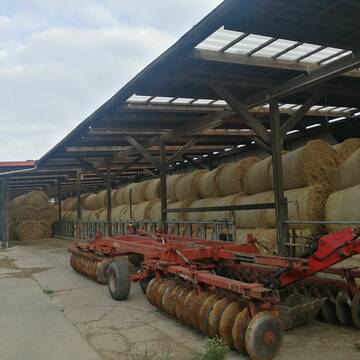
Heu 1.Schnitt 2021
Upahl
hermannmeyerzuborgsen
@hermannmeyerzuborgsen
Heu
Empfänger lädt ab
Rundballen
Regenfrei
3 weitere...
P+
Deprecated: Creation of dynamic property Zend_View_Helper_Ads::$adLink is deprecated in /var/www/stall-frei/htdocs/staging.stall-frei.de/library/Psf/View/Helper/Ads.php on line 108

Das Beste für die Hufe
Mechtersen
STALL-FREIde Marketing
@STALL-FREI-Marketing
Hufschmiede und Hufpfleger in Ihrer Nähe

B+

B+

Heu und Stroh in sehr guter Qualität
Nettetal
Agrarhandel J. Weyers e.K.
@Bergwiesenheu
Futter
Empfänger lädt ab
Rundballen
Wird verladen
1 weitere...
B+

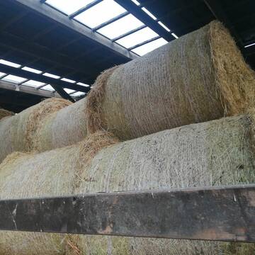
Heu in Rundballen (ca.130cm) super Qualität
Pronstorf
Caros Pferdeparadies
@KaOb
Heu
Rundballen
Regenfrei
Wird verladen
2 weitere...
B+

Persönlichkeitsentwicklung mit Pferden
Bad Salzuflen
Katja Dors
@Pferdezeiten
Begleite andere auf ihrem Entwicklungsweg und entdecke die transformative Kraft der pferdegestützten Persönlichkeitsentwicklung !
neu
R

10 Rb Heu/15 RB Öhmd/15 RB Stroh
Helmstadt
Juergen
@Juergen77
Einstreu
Empfänger lädt ab
Rundballen
Regenfrei
2 weitere...
B+

HD-Ballen Heu
Ginsweiler
Laura
@Heuverkauf_Ginsweiler
Heu
Kleinballen/HD-Ballen
Regenfrei
Wird verladen
2 weitere...
B+

Heu HD Ballen
Carlsberg
Maike Käpernick
@ReitschuleKaepernick
Heu
Empfänger lädt ab
Kleinballen/HD-Ballen
Bio
Regenfrei
2 weitere...
B+
Leider kein Vorschaubild
Leider kein Vorschaubild
Heu zu verkaufen
Bad Rappenau
Uwe Wolf
@Uwe_Wolf
Heu
Empfänger lädt ab
Rundballen
Regenfrei
2 weitere...
B+

Bio Heu
Mehlbach
irena-zinssmeister
@irena-zinssmeister
Heu
Empfänger lädt ab
Großballen
Bio
Regenfrei
2 weitere...
aktuell
B+
Newsletter abonnieren
Melde Dich für unseren Newsletter an und verpasse keine Neuigkeiten!
Deprecated: Creation of dynamic property Zend_View::$pageCount is deprecated in /var/www/stall-frei/htdocs/staging.stall-frei.de/library/vendor/shardj/zf1-future/library/Zend/View/Abstract.php on line 308
Deprecated: Creation of dynamic property Zend_View::$itemCountPerPage is deprecated in /var/www/stall-frei/htdocs/staging.stall-frei.de/library/vendor/shardj/zf1-future/library/Zend/View/Abstract.php on line 308
Deprecated: Creation of dynamic property Zend_View::$first is deprecated in /var/www/stall-frei/htdocs/staging.stall-frei.de/library/vendor/shardj/zf1-future/library/Zend/View/Abstract.php on line 308
Deprecated: Creation of dynamic property Zend_View::$current is deprecated in /var/www/stall-frei/htdocs/staging.stall-frei.de/library/vendor/shardj/zf1-future/library/Zend/View/Abstract.php on line 308
Deprecated: Creation of dynamic property Zend_View::$last is deprecated in /var/www/stall-frei/htdocs/staging.stall-frei.de/library/vendor/shardj/zf1-future/library/Zend/View/Abstract.php on line 308
Deprecated: Creation of dynamic property Zend_View::$previous is deprecated in /var/www/stall-frei/htdocs/staging.stall-frei.de/library/vendor/shardj/zf1-future/library/Zend/View/Abstract.php on line 308
Deprecated: Creation of dynamic property Zend_View::$next is deprecated in /var/www/stall-frei/htdocs/staging.stall-frei.de/library/vendor/shardj/zf1-future/library/Zend/View/Abstract.php on line 308
Deprecated: Creation of dynamic property Zend_View::$pagesInRange is deprecated in /var/www/stall-frei/htdocs/staging.stall-frei.de/library/vendor/shardj/zf1-future/library/Zend/View/Abstract.php on line 308
Deprecated: Creation of dynamic property Zend_View::$firstPageInRange is deprecated in /var/www/stall-frei/htdocs/staging.stall-frei.de/library/vendor/shardj/zf1-future/library/Zend/View/Abstract.php on line 308
Deprecated: Creation of dynamic property Zend_View::$lastPageInRange is deprecated in /var/www/stall-frei/htdocs/staging.stall-frei.de/library/vendor/shardj/zf1-future/library/Zend/View/Abstract.php on line 308
Deprecated: Creation of dynamic property Zend_View::$currentItemCount is deprecated in /var/www/stall-frei/htdocs/staging.stall-frei.de/library/vendor/shardj/zf1-future/library/Zend/View/Abstract.php on line 308
Deprecated: Creation of dynamic property Zend_View::$totalItemCount is deprecated in /var/www/stall-frei/htdocs/staging.stall-frei.de/library/vendor/shardj/zf1-future/library/Zend/View/Abstract.php on line 308
Deprecated: Creation of dynamic property Zend_View::$firstItemNumber is deprecated in /var/www/stall-frei/htdocs/staging.stall-frei.de/library/vendor/shardj/zf1-future/library/Zend/View/Abstract.php on line 308
Deprecated: Creation of dynamic property Zend_View::$lastItemNumber is deprecated in /var/www/stall-frei/htdocs/staging.stall-frei.de/library/vendor/shardj/zf1-future/library/Zend/View/Abstract.php on line 308
Deprecated: Creation of dynamic property Zend_View::$router is deprecated in /var/www/stall-frei/htdocs/staging.stall-frei.de/library/vendor/shardj/zf1-future/library/Zend/View/Abstract.php on line 308
Deprecated: Creation of dynamic property Zend_View::$urlParams is deprecated in /var/www/stall-frei/htdocs/staging.stall-frei.de/library/vendor/shardj/zf1-future/library/Zend/View/Abstract.php on line 308
Deprecated: Creation of dynamic property Zend_View::$showAds is deprecated in /var/www/stall-frei/htdocs/staging.stall-frei.de/library/vendor/shardj/zf1-future/library/Zend/View/Abstract.php on line 308
Deprecated: Creation of dynamic property Zend_View::$objectIds is deprecated in /var/www/stall-frei/htdocs/staging.stall-frei.de/library/vendor/shardj/zf1-future/library/Zend/View/Abstract.php on line 308
Deprecated: Creation of dynamic property Zend_View::$showNavbar is deprecated in /var/www/stall-frei/htdocs/staging.stall-frei.de/library/vendor/shardj/zf1-future/library/Zend/View/Abstract.php on line 308
Deprecated: Creation of dynamic property Zend_View::$showBreadcrumb is deprecated in /var/www/stall-frei/htdocs/staging.stall-frei.de/library/vendor/shardj/zf1-future/library/Zend/View/Abstract.php on line 308
Deprecated: Creation of dynamic property Zend_View::$showFooter is deprecated in /var/www/stall-frei/htdocs/staging.stall-frei.de/library/vendor/shardj/zf1-future/library/Zend/View/Abstract.php on line 308
Deprecated: Creation of dynamic property Zend_View::$showInternalAds is deprecated in /var/www/stall-frei/htdocs/staging.stall-frei.de/library/vendor/shardj/zf1-future/library/Zend/View/Abstract.php on line 308
Deprecated: Creation of dynamic property Zend_View::$blNoContent is deprecated in /var/www/stall-frei/htdocs/staging.stall-frei.de/library/vendor/shardj/zf1-future/library/Zend/View/Abstract.php on line 308
Deprecated: Creation of dynamic property Zend_View::$sMetaDesc is deprecated in /var/www/stall-frei/htdocs/staging.stall-frei.de/library/vendor/shardj/zf1-future/library/Zend/View/Abstract.php on line 308
Deprecated: Creation of dynamic property Zend_View::$useGmaps is deprecated in /var/www/stall-frei/htdocs/staging.stall-frei.de/library/vendor/shardj/zf1-future/library/Zend/View/Abstract.php on line 308
Deprecated: Creation of dynamic property Zend_View::$touches is deprecated in /var/www/stall-frei/htdocs/staging.stall-frei.de/library/vendor/shardj/zf1-future/library/Zend/View/Abstract.php on line 308
Deprecated: Creation of dynamic property Zend_View::$oProject is deprecated in /var/www/stall-frei/htdocs/staging.stall-frei.de/library/vendor/shardj/zf1-future/library/Zend/View/Abstract.php on line 308
Deprecated: Creation of dynamic property Zend_View::$pageHeadline is deprecated in /var/www/stall-frei/htdocs/staging.stall-frei.de/library/vendor/shardj/zf1-future/library/Zend/View/Abstract.php on line 308
Deprecated: Creation of dynamic property Zend_View::$disableLocationField is deprecated in /var/www/stall-frei/htdocs/staging.stall-frei.de/library/vendor/shardj/zf1-future/library/Zend/View/Abstract.php on line 308
Deprecated: Creation of dynamic property Zend_View::$isSearch is deprecated in /var/www/stall-frei/htdocs/staging.stall-frei.de/library/vendor/shardj/zf1-future/library/Zend/View/Abstract.php on line 308
Deprecated: Creation of dynamic property Zend_View::$pageTitle is deprecated in /var/www/stall-frei/htdocs/staging.stall-frei.de/library/vendor/shardj/zf1-future/library/Zend/View/Abstract.php on line 308
Deprecated: Creation of dynamic property Psf_Form_Element_Text::$class is deprecated in /var/www/stall-frei/htdocs/staging.stall-frei.de/library/vendor/shardj/zf1-future/library/Zend/Form/Element.php on line 874
Deprecated: Creation of dynamic property Psf_Form_Element_Text::$size is deprecated in /var/www/stall-frei/htdocs/staging.stall-frei.de/library/vendor/shardj/zf1-future/library/Zend/Form/Element.php on line 874
Deprecated: Creation of dynamic property Psf_Form_Element_Text::$placeholder is deprecated in /var/www/stall-frei/htdocs/staging.stall-frei.de/library/vendor/shardj/zf1-future/library/Zend/Form/Element.php on line 874
Deprecated: Creation of dynamic property Psf_Form_Element_Hidden::$class is deprecated in /var/www/stall-frei/htdocs/staging.stall-frei.de/library/vendor/shardj/zf1-future/library/Zend/Form/Element.php on line 874
Deprecated: Creation of dynamic property Psf_Form_Element_Hidden::$class is deprecated in /var/www/stall-frei/htdocs/staging.stall-frei.de/library/vendor/shardj/zf1-future/library/Zend/Form/Element.php on line 874
Deprecated: Creation of dynamic property Psf_Form_Element_Hidden::$class is deprecated in /var/www/stall-frei/htdocs/staging.stall-frei.de/library/vendor/shardj/zf1-future/library/Zend/Form/Element.php on line 874
Deprecated: Creation of dynamic property Psf_Form_Element_Hidden::$class is deprecated in /var/www/stall-frei/htdocs/staging.stall-frei.de/library/vendor/shardj/zf1-future/library/Zend/Form/Element.php on line 874
Deprecated: Creation of dynamic property Psf_Form_Element_Select::$class is deprecated in /var/www/stall-frei/htdocs/staging.stall-frei.de/library/vendor/shardj/zf1-future/library/Zend/Form/Element.php on line 874
Deprecated: Creation of dynamic property Psf_Form_Element_Select::$class is deprecated in /var/www/stall-frei/htdocs/staging.stall-frei.de/library/vendor/shardj/zf1-future/library/Zend/Form/Element.php on line 874
Deprecated: Creation of dynamic property Psf_Form_Element_Select::$class is deprecated in /var/www/stall-frei/htdocs/staging.stall-frei.de/library/vendor/shardj/zf1-future/library/Zend/Form/Element.php on line 874
Deprecated: Creation of dynamic property Psf_Form_Element_Select::$class is deprecated in /var/www/stall-frei/htdocs/staging.stall-frei.de/library/vendor/shardj/zf1-future/library/Zend/Form/Element.php on line 874
Deprecated: Creation of dynamic property Zend_View::$sort is deprecated in /var/www/stall-frei/htdocs/staging.stall-frei.de/library/vendor/shardj/zf1-future/library/Zend/View/Abstract.php on line 308
Deprecated: Creation of dynamic property Zend_View::$searchLocation is deprecated in /var/www/stall-frei/htdocs/staging.stall-frei.de/library/vendor/shardj/zf1-future/library/Zend/View/Abstract.php on line 308
Deprecated: Creation of dynamic property Zend_View::$locationHint is deprecated in /var/www/stall-frei/htdocs/staging.stall-frei.de/library/vendor/shardj/zf1-future/library/Zend/View/Abstract.php on line 308
Psf_GeoCoder_Abstract::getLocation: Wahrberg Get Location CachedOrLive
Psf_GeoCoder_Abstract::getCachedOrLive: Wahrberg
Psf_GeoCoder_Abstract::convertLocationResult
{"documentation":"https:\/\/opencagedata.com\/api","licenses":[{"name":"see attribution guide","url":"https:\/\/opencagedata.com\/credits"}],"results":[{"bounds":{"northeast":{"lat":51.677384,"lng":9.9382923},"southwest":{"lat":51.677284,"lng":9.9381923}},"components":{"ISO_3166-1_alpha-2":"DE","ISO_3166-1_alpha-3":"DEU","ISO_3166-2":["DE-NI"],"_category":"natural\/water","_normalized_city":"Northeim","_type":"peak","continent":"Europe","country":"Deutschland","country_code":"de","county":"Landkreis Northeim","peak":"Wahrberg","political_union":"European Union","state":"Niedersachsen","state_code":"NI","town":"Northeim"},"confidence":9,"formatted":"Wahrberg, Northeim, Niedersachsen, Deutschland","geometry":{"lat":51.677334,"lng":9.9382423}},{"bounds":{"northeast":{"lat":53.0801201,"lng":12.1578168},"southwest":{"lat":53.0800201,"lng":12.1577168}},"components":{"ISO_3166-1_alpha-2":"DE","ISO_3166-1_alpha-3":"DEU","ISO_3166-2":["DE-BB"],"_category":"natural\/water","_normalized_city":"Gro\u00df Pankow (Prignitz)","_type":"peak","continent":"Europe","country":"Deutschland","country_code":"de","county":"Prignitz","peak":"Wahrberg","political_union":"European Union","state":"Brandenburg","state_code":"BB","village":"Gro\u00df Pankow (Prignitz)"},"confidence":9,"formatted":"Wahrberg, Gro\u00df Pankow (Prignitz), Brandenburg, Deutschland","geometry":{"lat":53.0800701,"lng":12.1577668}},{"bounds":{"northeast":{"lat":51.8665101,"lng":10.7053215},"southwest":{"lat":51.8664101,"lng":10.7052215}},"components":{"ISO_3166-1_alpha-2":"DE","ISO_3166-1_alpha-3":"DEU","ISO_3166-2":["DE-ST"],"_category":"natural\/water","_normalized_city":"Ilsenburg","_type":"peak","continent":"Europe","country":"Deutschland","country_code":"de","county":"Landkreis Harz","peak":"Wahrberg","political_union":"European Union","postcode":"38871","state":"Sachsen-Anhalt","state_code":"ST","town":"Ilsenburg"},"confidence":9,"formatted":"Wahrberg, 38871 Ilsenburg, Deutschland","geometry":{"lat":51.8664601,"lng":10.7052715}},{"bounds":{"northeast":{"lat":51.6512994,"lng":10.3800659},"southwest":{"lat":51.6511994,"lng":10.3799659}},"components":{"ISO_3166-1_alpha-2":"DE","ISO_3166-1_alpha-3":"DEU","ISO_3166-2":["DE-NI"],"_category":"natural\/water","_normalized_city":"Harz (Landkreis G\u00f6ttingen)","_type":"peak","city":"Harz (Landkreis G\u00f6ttingen)","continent":"Europe","country":"Deutschland","country_code":"de","county":"Landkreis G\u00f6ttingen","peak":"Wahrberg","political_union":"European Union","state":"Niedersachsen","state_code":"NI"},"confidence":9,"formatted":"Wahrberg, Harz (Landkreis G\u00f6ttingen), Niedersachsen, Deutschland","geometry":{"lat":51.6512494,"lng":10.3800159}},{"bounds":{"northeast":{"lat":52.2815975,"lng":11.3338043},"southwest":{"lat":52.2814975,"lng":11.3337043}},"components":{"ISO_3166-1_alpha-2":"DE","ISO_3166-1_alpha-3":"DEU","ISO_3166-2":["DE-ST"],"_category":"natural\/water","_normalized_city":"Haldensleben","_type":"peak","continent":"Europe","country":"Deutschland","country_code":"de","county":"B\u00f6rde","peak":"Wahrberg","political_union":"European Union","postcode":"39345","state":"Sachsen-Anhalt","state_code":"ST","town":"Haldensleben"},"confidence":9,"formatted":"Wahrberg, 39345 Haldensleben, Deutschland","geometry":{"lat":52.2815475,"lng":11.3337543}},{"bounds":{"northeast":{"lat":54.8512984,"lng":9.618018},"southwest":{"lat":54.8112984,"lng":9.578018}},"components":{"ISO_3166-1_alpha-2":"DE","ISO_3166-1_alpha-3":"DEU","ISO_3166-2":["DE-SH"],"_category":"place","_normalized_city":"Gl\u00fccksburg (Ostsee)","_type":"hamlet","city":"Gl\u00fccksburg (Ostsee)","continent":"Europe","country":"Deutschland","country_code":"de","county":"Kreis Schleswig-Flensburg","hamlet":"Wahrberg","political_union":"European Union","postcode":"24960","state":"Schleswig-Holstein","state_code":"SH"},"confidence":7,"formatted":"Wahrberg, 24960 Gl\u00fccksburg (Ostsee), Deutschland","geometry":{"lat":54.8312984,"lng":9.598018}},{"bounds":{"northeast":{"lat":51.6524139,"lng":10.3782696},"southwest":{"lat":51.6523139,"lng":10.3781696}},"components":{"ISO_3166-1_alpha-2":"DE","ISO_3166-1_alpha-3":"DEU","ISO_3166-2":["DE-NI"],"_category":"building","_normalized_city":"Herzberg am Harz","_type":"building","city":"Herzberg am Harz","continent":"Europe","country":"Deutschland","country_code":"de","county":"Landkreis G\u00f6ttingen","isolated_dwelling":"Wahrberg","political_union":"European Union","postcode":"37412","state":"Niedersachsen","state_code":"NI","town":"Herzberg am Harz"},"confidence":10,"formatted":"Wahrberg, 37412 Herzberg am Harz, Deutschland","geometry":{"lat":51.6523639,"lng":10.3782196}},{"bounds":{"northeast":{"lat":51.8687243,"lng":10.7075284},"southwest":{"lat":51.8653585,"lng":10.6994537}},"components":{"ISO_3166-1_alpha-2":"DE","ISO_3166-1_alpha-3":"DEU","ISO_3166-2":["DE-ST"],"_category":"natural\/water","_normalized_city":"Ilsenburg","_type":"forest","city_district":"Dr\u00fcbeck","continent":"Europe","country":"Deutschland","country_code":"de","county":"Landkreis Harz","forest":"Wahrberg","political_union":"European Union","postcode":"38871","state":"Sachsen-Anhalt","state_code":"ST","town":"Ilsenburg"},"confidence":9,"formatted":"Wahrberg, 38871 Ilsenburg, Deutschland","geometry":{"lat":51.8670965,"lng":10.7045236}},{"bounds":{"northeast":{"lat":54.8317358,"lng":9.6023664},"southwest":{"lat":54.830943,"lng":9.5875753}},"components":{"ISO_3166-1_alpha-2":"DE","ISO_3166-1_alpha-3":"DEU","ISO_3166-2":["DE-SH"],"_category":"road","_normalized_city":"Gl\u00fccksburg (Ostsee)","_type":"road","city":"Gl\u00fccksburg (Ostsee)","continent":"Europe","country":"Deutschland","country_code":"de","county":"Kreis Schleswig-Flensburg","hamlet":"Wahrberg","political_union":"European Union","postcode":"24960","road":"Wahrberg","state":"Schleswig-Holstein","state_code":"SH"},"confidence":9,"formatted":"Wahrberg, 24960 Gl\u00fccksburg (Ostsee), Deutschland","geometry":{"lat":54.8311364,"lng":9.5949667}},{"components":{"ISO_3166-1_alpha-2":"FR","ISO_3166-1_alpha-3":"FRA","ISO_3166-2":["FR-IDF","FR-92"],"_category":"road","_normalized_city":"Levallois-Perret","_type":"road","city":"Levallois-Perret","continent":"Europe","country":"France","country_code":"fr","county":"Hauts-de-Seine","local_authority":"M\u00e9tropole du Grand Paris","political_union":"European Union","postcode":"92300","road":"Rue Charles Deutschmann","state":"\u00cele-de-France","state_code":"IDF"},"confidence":2,"formatted":"Rue Charles Deutschmann, 92300 Levallois-Perret, France","geometry":{"lat":48.900049,"lng":2.2842}}],"status":{"code":200,"message":"OK"},"stay_informed":{"blog":"https:\/\/blog.opencagedata.com","mastodon":"https:\/\/en.osm.town\/@opencage"},"thanks":"For using an OpenCage API","timestamp":{"created_http":"Fri, 06 Feb 2026 05:12:41 GMT","created_unix":1770354761},"total_results":10}Array
(
[0] => stdClass Object
(
[bounds] => stdClass Object
(
[northeast] => stdClass Object
(
[lat] => 51.677384
[lng] => 9.9382923
)
[southwest] => stdClass Object
(
[lat] => 51.677284
[lng] => 9.9381923
)
)
[components] => stdClass Object
(
[ISO_3166-1_alpha-2] => DE
[ISO_3166-1_alpha-3] => DEU
[ISO_3166-2] => Array
(
[0] => DE-NI
)
[_category] => natural/water
[_normalized_city] => Northeim
[_type] => peak
[continent] => Europe
[country] => Deutschland
[country_code] => de
[county] => Landkreis Northeim
[peak] => Wahrberg
[political_union] => European Union
[state] => Niedersachsen
[state_code] => NI
[town] => Northeim
)
[confidence] => 9
[formatted] => Wahrberg, Northeim, Niedersachsen, Deutschland
[geometry] => stdClass Object
(
[lat] => 51.677334
[lng] => 9.9382423
)
)
[1] => stdClass Object
(
[bounds] => stdClass Object
(
[northeast] => stdClass Object
(
[lat] => 53.0801201
[lng] => 12.1578168
)
[southwest] => stdClass Object
(
[lat] => 53.0800201
[lng] => 12.1577168
)
)
[components] => stdClass Object
(
[ISO_3166-1_alpha-2] => DE
[ISO_3166-1_alpha-3] => DEU
[ISO_3166-2] => Array
(
[0] => DE-BB
)
[_category] => natural/water
[_normalized_city] => Groß Pankow (Prignitz)
[_type] => peak
[continent] => Europe
[country] => Deutschland
[country_code] => de
[county] => Prignitz
[peak] => Wahrberg
[political_union] => European Union
[state] => Brandenburg
[state_code] => BB
[village] => Groß Pankow (Prignitz)
)
[confidence] => 9
[formatted] => Wahrberg, Groß Pankow (Prignitz), Brandenburg, Deutschland
[geometry] => stdClass Object
(
[lat] => 53.0800701
[lng] => 12.1577668
)
)
[2] => stdClass Object
(
[bounds] => stdClass Object
(
[northeast] => stdClass Object
(
[lat] => 51.8665101
[lng] => 10.7053215
)
[southwest] => stdClass Object
(
[lat] => 51.8664101
[lng] => 10.7052215
)
)
[components] => stdClass Object
(
[ISO_3166-1_alpha-2] => DE
[ISO_3166-1_alpha-3] => DEU
[ISO_3166-2] => Array
(
[0] => DE-ST
)
[_category] => natural/water
[_normalized_city] => Ilsenburg
[_type] => peak
[continent] => Europe
[country] => Deutschland
[country_code] => de
[county] => Landkreis Harz
[peak] => Wahrberg
[political_union] => European Union
[postcode] => 38871
[state] => Sachsen-Anhalt
[state_code] => ST
[town] => Ilsenburg
)
[confidence] => 9
[formatted] => Wahrberg, 38871 Ilsenburg, Deutschland
[geometry] => stdClass Object
(
[lat] => 51.8664601
[lng] => 10.7052715
)
)
[3] => stdClass Object
(
[bounds] => stdClass Object
(
[northeast] => stdClass Object
(
[lat] => 51.6512994
[lng] => 10.3800659
)
[southwest] => stdClass Object
(
[lat] => 51.6511994
[lng] => 10.3799659
)
)
[components] => stdClass Object
(
[ISO_3166-1_alpha-2] => DE
[ISO_3166-1_alpha-3] => DEU
[ISO_3166-2] => Array
(
[0] => DE-NI
)
[_category] => natural/water
[_normalized_city] => Harz (Landkreis Göttingen)
[_type] => peak
[city] => Harz (Landkreis Göttingen)
[continent] => Europe
[country] => Deutschland
[country_code] => de
[county] => Landkreis Göttingen
[peak] => Wahrberg
[political_union] => European Union
[state] => Niedersachsen
[state_code] => NI
)
[confidence] => 9
[formatted] => Wahrberg, Harz (Landkreis Göttingen), Niedersachsen, Deutschland
[geometry] => stdClass Object
(
[lat] => 51.6512494
[lng] => 10.3800159
)
)
[4] => stdClass Object
(
[bounds] => stdClass Object
(
[northeast] => stdClass Object
(
[lat] => 52.2815975
[lng] => 11.3338043
)
[southwest] => stdClass Object
(
[lat] => 52.2814975
[lng] => 11.3337043
)
)
[components] => stdClass Object
(
[ISO_3166-1_alpha-2] => DE
[ISO_3166-1_alpha-3] => DEU
[ISO_3166-2] => Array
(
[0] => DE-ST
)
[_category] => natural/water
[_normalized_city] => Haldensleben
[_type] => peak
[continent] => Europe
[country] => Deutschland
[country_code] => de
[county] => Börde
[peak] => Wahrberg
[political_union] => European Union
[postcode] => 39345
[state] => Sachsen-Anhalt
[state_code] => ST
[town] => Haldensleben
)
[confidence] => 9
[formatted] => Wahrberg, 39345 Haldensleben, Deutschland
[geometry] => stdClass Object
(
[lat] => 52.2815475
[lng] => 11.3337543
)
)
[5] => stdClass Object
(
[bounds] => stdClass Object
(
[northeast] => stdClass Object
(
[lat] => 54.8512984
[lng] => 9.618018
)
[southwest] => stdClass Object
(
[lat] => 54.8112984
[lng] => 9.578018
)
)
[components] => stdClass Object
(
[ISO_3166-1_alpha-2] => DE
[ISO_3166-1_alpha-3] => DEU
[ISO_3166-2] => Array
(
[0] => DE-SH
)
[_category] => place
[_normalized_city] => Glücksburg (Ostsee)
[_type] => hamlet
[city] => Glücksburg (Ostsee)
[continent] => Europe
[country] => Deutschland
[country_code] => de
[county] => Kreis Schleswig-Flensburg
[hamlet] => Wahrberg
[political_union] => European Union
[postcode] => 24960
[state] => Schleswig-Holstein
[state_code] => SH
)
[confidence] => 7
[formatted] => Wahrberg, 24960 Glücksburg (Ostsee), Deutschland
[geometry] => stdClass Object
(
[lat] => 54.8312984
[lng] => 9.598018
)
)
[6] => stdClass Object
(
[bounds] => stdClass Object
(
[northeast] => stdClass Object
(
[lat] => 51.6524139
[lng] => 10.3782696
)
[southwest] => stdClass Object
(
[lat] => 51.6523139
[lng] => 10.3781696
)
)
[components] => stdClass Object
(
[ISO_3166-1_alpha-2] => DE
[ISO_3166-1_alpha-3] => DEU
[ISO_3166-2] => Array
(
[0] => DE-NI
)
[_category] => building
[_normalized_city] => Herzberg am Harz
[_type] => building
[city] => Herzberg am Harz
[continent] => Europe
[country] => Deutschland
[country_code] => de
[county] => Landkreis Göttingen
[isolated_dwelling] => Wahrberg
[political_union] => European Union
[postcode] => 37412
[state] => Niedersachsen
[state_code] => NI
[town] => Herzberg am Harz
)
[confidence] => 10
[formatted] => Wahrberg, 37412 Herzberg am Harz, Deutschland
[geometry] => stdClass Object
(
[lat] => 51.6523639
[lng] => 10.3782196
)
)
[7] => stdClass Object
(
[bounds] => stdClass Object
(
[northeast] => stdClass Object
(
[lat] => 51.8687243
[lng] => 10.7075284
)
[southwest] => stdClass Object
(
[lat] => 51.8653585
[lng] => 10.6994537
)
)
[components] => stdClass Object
(
[ISO_3166-1_alpha-2] => DE
[ISO_3166-1_alpha-3] => DEU
[ISO_3166-2] => Array
(
[0] => DE-ST
)
[_category] => natural/water
[_normalized_city] => Ilsenburg
[_type] => forest
[city_district] => Drübeck
[continent] => Europe
[country] => Deutschland
[country_code] => de
[county] => Landkreis Harz
[forest] => Wahrberg
[political_union] => European Union
[postcode] => 38871
[state] => Sachsen-Anhalt
[state_code] => ST
[town] => Ilsenburg
)
[confidence] => 9
[formatted] => Wahrberg, 38871 Ilsenburg, Deutschland
[geometry] => stdClass Object
(
[lat] => 51.8670965
[lng] => 10.7045236
)
)
[8] => stdClass Object
(
[bounds] => stdClass Object
(
[northeast] => stdClass Object
(
[lat] => 54.8317358
[lng] => 9.6023664
)
[southwest] => stdClass Object
(
[lat] => 54.830943
[lng] => 9.5875753
)
)
[components] => stdClass Object
(
[ISO_3166-1_alpha-2] => DE
[ISO_3166-1_alpha-3] => DEU
[ISO_3166-2] => Array
(
[0] => DE-SH
)
[_category] => road
[_normalized_city] => Glücksburg (Ostsee)
[_type] => road
[city] => Glücksburg (Ostsee)
[continent] => Europe
[country] => Deutschland
[country_code] => de
[county] => Kreis Schleswig-Flensburg
[hamlet] => Wahrberg
[political_union] => European Union
[postcode] => 24960
[road] => Wahrberg
[state] => Schleswig-Holstein
[state_code] => SH
)
[confidence] => 9
[formatted] => Wahrberg, 24960 Glücksburg (Ostsee), Deutschland
[geometry] => stdClass Object
(
[lat] => 54.8311364
[lng] => 9.5949667
)
)
[9] => stdClass Object
(
[components] => stdClass Object
(
[ISO_3166-1_alpha-2] => FR
[ISO_3166-1_alpha-3] => FRA
[ISO_3166-2] => Array
(
[0] => FR-IDF
[1] => FR-92
)
[_category] => road
[_normalized_city] => Levallois-Perret
[_type] => road
[city] => Levallois-Perret
[continent] => Europe
[country] => France
[country_code] => fr
[county] => Hauts-de-Seine
[local_authority] => Métropole du Grand Paris
[political_union] => European Union
[postcode] => 92300
[road] => Rue Charles Deutschmann
[state] => Île-de-France
[state_code] => IDF
)
[confidence] => 2
[formatted] => Rue Charles Deutschmann, 92300 Levallois-Perret, France
[geometry] => stdClass Object
(
[lat] => 48.900049
[lng] => 2.2842
)
)
)
Psf_GeoCoder_OpenCageData::getKeyMap: 0
stdClass Object
(
    [bounds] => stdClass Object
        (
            [northeast] => stdClass Object
                (
                    [lat] => 51.677384
                    [lng] => 9.9382923
                )

            [southwest] => stdClass Object
                (
                    [lat] => 51.677284
                    [lng] => 9.9381923
                )

        )

    [components] => stdClass Object
        (
            [ISO_3166-1_alpha-2] => DE
            [ISO_3166-1_alpha-3] => DEU
            [ISO_3166-2] => Array
                (
                    [0] => DE-NI
                )

            [_category] => natural/water
            [_normalized_city] => Northeim
            [_type] => peak
            [continent] => Europe
            [country] => Deutschland
            [country_code] => de
            [county] => Landkreis Northeim
            [peak] => Wahrberg
            [political_union] => European Union
            [state] => Niedersachsen
            [state_code] => NI
            [town] => Northeim
        )

    [confidence] => 9
    [formatted] => Wahrberg, Northeim, Niedersachsen, Deutschland
    [geometry] => stdClass Object
        (
            [lat] => 51.677334
            [lng] => 9.9382423
        )

)
Psf_GeoCoder_OpenCageData::getCounty: Northeim
Psf_GeoCoder_OpenCageData::addMissingData REFETCH!
Array
(
    [address] => Wahrberg, Northeim, Niedersachsen, Deutschland
    [type] => peak
    [street] =>
    [city] => Northeim
    [county] => Northeim
    [state] => Niedersachsen
    [zip] =>
    [country] => Deutschland
    [suburb] =>
    [countrycode] => de
    [latitude] => 51.677334
    [longitude] => 9.9382423
    [accuracy] => 1
    [confidence] => 9
    [bounds] => stdClass Object
        (
            [northeast] => stdClass Object
                (
                    [lat] => 51.677384
                    [lng] => 9.9382923
                )

            [southwest] => stdClass Object
                (
                    [lat] => 51.677284
                    [lng] => 9.9381923
                )

        )

)
reformat!
Array
(
    [address] => Wahrberg, Northeim, Niedersachsen, Deutschland
    [type] => peak
    [street] =>
    [city] => Northeim
    [county] => Northeim
    [state] => Niedersachsen
    [zip] =>
    [country] => Deutschland
    [suburb] =>
    [countrycode] => de
    [latitude] => 51.677334
    [longitude] => 9.9382423
    [accuracy] => 1
    [confidence] => 9
    [bounds] => stdClass Object
        (
            [northeast] => stdClass Object
                (
                    [lat] => 51.677384
                    [lng] => 9.9382923
                )

            [southwest] => stdClass Object
                (
                    [lat] => 51.677284
                    [lng] => 9.9381923
                )

        )

    [place] => Northeim, Niedersachsen
    [hash] => 705694e7d32daf1bb8b86098960e5edc
)
Psf_GeoCoder_OpenCageData::getKeyMap: 1
stdClass Object
(
    [bounds] => stdClass Object
        (
            [northeast] => stdClass Object
                (
                    [lat] => 53.0801201
                    [lng] => 12.1578168
                )

            [southwest] => stdClass Object
                (
                    [lat] => 53.0800201
                    [lng] => 12.1577168
                )

        )

    [components] => stdClass Object
        (
            [ISO_3166-1_alpha-2] => DE
            [ISO_3166-1_alpha-3] => DEU
            [ISO_3166-2] => Array
                (
                    [0] => DE-BB
                )

            [_category] => natural/water
            [_normalized_city] => Groß Pankow (Prignitz)
            [_type] => peak
            [continent] => Europe
            [country] => Deutschland
            [country_code] => de
            [county] => Prignitz
            [peak] => Wahrberg
            [political_union] => European Union
            [state] => Brandenburg
            [state_code] => BB
            [village] => Groß Pankow (Prignitz)
        )

    [confidence] => 9
    [formatted] => Wahrberg, Groß Pankow (Prignitz), Brandenburg, Deutschland
    [geometry] => stdClass Object
        (
            [lat] => 53.0800701
            [lng] => 12.1577668
        )

)
Psf_GeoCoder_OpenCageData::getCounty: Prignitz
Psf_GeoCoder_OpenCageData::addMissingData REFETCH!
Array
(
    [address] => Wahrberg, Groß Pankow (Prignitz), Brandenburg, Deutschland
    [type] => peak
    [street] =>
    [city] => Groß Pankow (Prignitz)
    [county] => Prignitz
    [state] => Brandenburg
    [zip] =>
    [country] => Deutschland
    [suburb] =>
    [countrycode] => de
    [latitude] => 53.0800701
    [longitude] => 12.1577668
    [accuracy] => 1
    [confidence] => 9
    [bounds] => stdClass Object
        (
            [northeast] => stdClass Object
                (
                    [lat] => 53.0801201
                    [lng] => 12.1578168
                )

            [southwest] => stdClass Object
                (
                    [lat] => 53.0800201
                    [lng] => 12.1577168
                )

        )

)
reformat!
Array
(
    [address] => Wahrberg, Groß Pankow (Prignitz), Brandenburg, Deutschland
    [type] => peak
    [street] =>
    [city] => Groß Pankow (Prignitz)
    [county] => Prignitz
    [state] => Brandenburg
    [zip] =>
    [country] => Deutschland
    [suburb] =>
    [countrycode] => de
    [latitude] => 53.0800701
    [longitude] => 12.1577668
    [accuracy] => 1
    [confidence] => 9
    [bounds] => stdClass Object
        (
            [northeast] => stdClass Object
                (
                    [lat] => 53.0801201
                    [lng] => 12.1578168
                )

            [southwest] => stdClass Object
                (
                    [lat] => 53.0800201
                    [lng] => 12.1577168
                )

        )

    [place] => Groß Pankow (Prignitz), Brandenburg
    [hash] => f2bfd6e0275f42a35fe2fed9372ffc64
)
Psf_GeoCoder_OpenCageData::getKeyMap: 2
stdClass Object
(
    [bounds] => stdClass Object
        (
            [northeast] => stdClass Object
                (
                    [lat] => 51.8665101
                    [lng] => 10.7053215
                )

            [southwest] => stdClass Object
                (
                    [lat] => 51.8664101
                    [lng] => 10.7052215
                )

        )

    [components] => stdClass Object
        (
            [ISO_3166-1_alpha-2] => DE
            [ISO_3166-1_alpha-3] => DEU
            [ISO_3166-2] => Array
                (
                    [0] => DE-ST
                )

            [_category] => natural/water
            [_normalized_city] => Ilsenburg
            [_type] => peak
            [continent] => Europe
            [country] => Deutschland
            [country_code] => de
            [county] => Landkreis Harz
            [peak] => Wahrberg
            [political_union] => European Union
            [postcode] => 38871
            [state] => Sachsen-Anhalt
            [state_code] => ST
            [town] => Ilsenburg
        )

    [confidence] => 9
    [formatted] => Wahrberg, 38871 Ilsenburg, Deutschland
    [geometry] => stdClass Object
        (
            [lat] => 51.8664601
            [lng] => 10.7052715
        )

)
Psf_GeoCoder_OpenCageData::getCounty: Harz
Psf_GeoCoder_OpenCageData::addMissingData REFETCH!
Array
(
    [address] => Wahrberg, 38871 Ilsenburg, Deutschland
    [type] => peak
    [street] =>
    [city] => Ilsenburg
    [county] => Harz
    [state] => Sachsen-Anhalt
    [zip] => 38871
    [country] => Deutschland
    [suburb] =>
    [countrycode] => de
    [latitude] => 51.8664601
    [longitude] => 10.7052715
    [accuracy] => 1
    [confidence] => 9
    [bounds] => stdClass Object
        (
            [northeast] => stdClass Object
                (
                    [lat] => 51.8665101
                    [lng] => 10.7053215
                )

            [southwest] => stdClass Object
                (
                    [lat] => 51.8664101
                    [lng] => 10.7052215
                )

        )

)
reformat!
Array
(
    [address] => Wahrberg, 38871 Ilsenburg, Deutschland
    [type] => peak
    [street] =>
    [city] => Ilsenburg
    [county] => Harz
    [state] => Sachsen-Anhalt
    [zip] => 38871
    [country] => Deutschland
    [suburb] =>
    [countrycode] => de
    [latitude] => 51.8664601
    [longitude] => 10.7052715
    [accuracy] => 1
    [confidence] => 9
    [bounds] => stdClass Object
        (
            [northeast] => stdClass Object
                (
                    [lat] => 51.8665101
                    [lng] => 10.7053215
                )

            [southwest] => stdClass Object
                (
                    [lat] => 51.8664101
                    [lng] => 10.7052215
                )

        )

    [place] => 38871 Ilsenburg, Sachsen-Anhalt
    [hash] => dd5514df73850f8c31d7119faf1b5eb9
)
Psf_GeoCoder_OpenCageData::getKeyMap: 3
stdClass Object
(
    [bounds] => stdClass Object
        (
            [northeast] => stdClass Object
                (
                    [lat] => 51.6512994
                    [lng] => 10.3800659
                )

            [southwest] => stdClass Object
                (
                    [lat] => 51.6511994
                    [lng] => 10.3799659
                )

        )

    [components] => stdClass Object
        (
            [ISO_3166-1_alpha-2] => DE
            [ISO_3166-1_alpha-3] => DEU
            [ISO_3166-2] => Array
                (
                    [0] => DE-NI
                )

            [_category] => natural/water
            [_normalized_city] => Harz (Landkreis Göttingen)
            [_type] => peak
            [city] => Harz (Landkreis Göttingen)
            [continent] => Europe
            [country] => Deutschland
            [country_code] => de
            [county] => Landkreis Göttingen
            [peak] => Wahrberg
            [political_union] => European Union
            [state] => Niedersachsen
            [state_code] => NI
        )

    [confidence] => 9
    [formatted] => Wahrberg, Harz (Landkreis Göttingen), Niedersachsen, Deutschland
    [geometry] => stdClass Object
        (
            [lat] => 51.6512494
            [lng] => 10.3800159
        )

)
Psf_GeoCoder_OpenCageData::getCounty: Göttingen
Psf_GeoCoder_OpenCageData::addMissingData REFETCH!
Array
(
    [address] => Wahrberg, Harz (Landkreis Göttingen), Niedersachsen, Deutschland
    [type] => peak
    [street] =>
    [city] => Harz (Landkreis Göttingen)
    [county] => Göttingen
    [state] => Niedersachsen
    [zip] =>
    [country] => Deutschland
    [suburb] =>
    [countrycode] => de
    [latitude] => 51.6512494
    [longitude] => 10.3800159
    [accuracy] => 1
    [confidence] => 9
    [bounds] => stdClass Object
        (
            [northeast] => stdClass Object
                (
                    [lat] => 51.6512994
                    [lng] => 10.3800659
                )

            [southwest] => stdClass Object
                (
                    [lat] => 51.6511994
                    [lng] => 10.3799659
                )

        )

)
reformat!
Array
(
    [address] => Wahrberg, Harz (Landkreis Göttingen), Niedersachsen, Deutschland
    [type] => peak
    [street] =>
    [city] => Harz (Landkreis Göttingen)
    [county] => Göttingen
    [state] => Niedersachsen
    [zip] =>
    [country] => Deutschland
    [suburb] =>
    [countrycode] => de
    [latitude] => 51.6512494
    [longitude] => 10.3800159
    [accuracy] => 1
    [confidence] => 9
    [bounds] => stdClass Object
        (
            [northeast] => stdClass Object
                (
                    [lat] => 51.6512994
                    [lng] => 10.3800659
                )

            [southwest] => stdClass Object
                (
                    [lat] => 51.6511994
                    [lng] => 10.3799659
                )

        )

    [place] => Harz (Landkreis Göttingen), Niedersachsen
    [hash] => 7faf63f09126b2d129631c60e0eeac2b
)
Psf_GeoCoder_OpenCageData::getKeyMap: 4
stdClass Object
(
    [bounds] => stdClass Object
        (
            [northeast] => stdClass Object
                (
                    [lat] => 52.2815975
                    [lng] => 11.3338043
                )

            [southwest] => stdClass Object
                (
                    [lat] => 52.2814975
                    [lng] => 11.3337043
                )

        )

    [components] => stdClass Object
        (
            [ISO_3166-1_alpha-2] => DE
            [ISO_3166-1_alpha-3] => DEU
            [ISO_3166-2] => Array
                (
                    [0] => DE-ST
                )

            [_category] => natural/water
            [_normalized_city] => Haldensleben
            [_type] => peak
            [continent] => Europe
            [country] => Deutschland
            [country_code] => de
            [county] => Börde
            [peak] => Wahrberg
            [political_union] => European Union
            [postcode] => 39345
            [state] => Sachsen-Anhalt
            [state_code] => ST
            [town] => Haldensleben
        )

    [confidence] => 9
    [formatted] => Wahrberg, 39345 Haldensleben, Deutschland
    [geometry] => stdClass Object
        (
            [lat] => 52.2815475
            [lng] => 11.3337543
        )

)
Psf_GeoCoder_OpenCageData::getCounty: Börde
Psf_GeoCoder_OpenCageData::addMissingData REFETCH!
Array
(
    [address] => Wahrberg, 39345 Haldensleben, Deutschland
    [type] => peak
    [street] =>
    [city] => Haldensleben
    [county] => Börde
    [state] => Sachsen-Anhalt
    [zip] => 39345
    [country] => Deutschland
    [suburb] =>
    [countrycode] => de
    [latitude] => 52.2815475
    [longitude] => 11.3337543
    [accuracy] => 1
    [confidence] => 9
    [bounds] => stdClass Object
        (
            [northeast] => stdClass Object
                (
                    [lat] => 52.2815975
                    [lng] => 11.3338043
                )

            [southwest] => stdClass Object
                (
                    [lat] => 52.2814975
                    [lng] => 11.3337043
                )

        )

)
reformat!
Array
(
    [address] => Wahrberg, 39345 Haldensleben, Deutschland
    [type] => peak
    [street] =>
    [city] => Haldensleben
    [county] => Börde
    [state] => Sachsen-Anhalt
    [zip] => 39345
    [country] => Deutschland
    [suburb] =>
    [countrycode] => de
    [latitude] => 52.2815475
    [longitude] => 11.3337543
    [accuracy] => 1
    [confidence] => 9
    [bounds] => stdClass Object
        (
            [northeast] => stdClass Object
                (
                    [lat] => 52.2815975
                    [lng] => 11.3338043
                )

            [southwest] => stdClass Object
                (
                    [lat] => 52.2814975
                    [lng] => 11.3337043
                )

        )

    [place] => 39345 Haldensleben, Sachsen-Anhalt
    [hash] => 777d645669e5c199a85d786ad711269a
)
Psf_GeoCoder_OpenCageData::getKeyMap: 5
stdClass Object
(
    [bounds] => stdClass Object
        (
            [northeast] => stdClass Object
                (
                    [lat] => 54.8512984
                    [lng] => 9.618018
                )

            [southwest] => stdClass Object
                (
                    [lat] => 54.8112984
                    [lng] => 9.578018
                )

        )

    [components] => stdClass Object
        (
            [ISO_3166-1_alpha-2] => DE
            [ISO_3166-1_alpha-3] => DEU
            [ISO_3166-2] => Array
                (
                    [0] => DE-SH
                )

            [_category] => place
            [_normalized_city] => Glücksburg (Ostsee)
            [_type] => hamlet
            [city] => Glücksburg (Ostsee)
            [continent] => Europe
            [country] => Deutschland
            [country_code] => de
            [county] => Kreis Schleswig-Flensburg
            [hamlet] => Wahrberg
            [political_union] => European Union
            [postcode] => 24960
            [state] => Schleswig-Holstein
            [state_code] => SH
        )

    [confidence] => 7
    [formatted] => Wahrberg, 24960 Glücksburg (Ostsee), Deutschland
    [geometry] => stdClass Object
        (
            [lat] => 54.8312984
            [lng] => 9.598018
        )

)
Psf_GeoCoder_OpenCageData::getCounty: Schleswig-Flensburg
Psf_GeoCoder_OpenCageData::addMissingData REFETCH!
Array
(
    [address] => Wahrberg, 24960 Glücksburg (Ostsee), Deutschland
    [type] => hamlet
    [street] => Wahrberg
    [city] => Glücksburg (Ostsee)
    [county] => Schleswig-Flensburg
    [state] => Schleswig-Holstein
    [zip] => 24960
    [country] => Deutschland
    [suburb] =>
    [countrycode] => de
    [latitude] => 54.8312984
    [longitude] => 9.598018
    [accuracy] => 1
    [confidence] => 7
    [bounds] => stdClass Object
        (
            [northeast] => stdClass Object
                (
                    [lat] => 54.8512984
                    [lng] => 9.618018
                )

            [southwest] => stdClass Object
                (
                    [lat] => 54.8112984
                    [lng] => 9.578018
                )

        )

)
reformat!
Array
(
    [address] => Wahrberg, 24960 Glücksburg (Ostsee), Deutschland
    [type] => hamlet
    [street] => Wahrberg
    [city] => Glücksburg (Ostsee)
    [county] => Schleswig-Flensburg
    [state] => Schleswig-Holstein
    [zip] => 24960
    [country] => Deutschland
    [suburb] =>
    [countrycode] => de
    [latitude] => 54.8312984
    [longitude] => 9.598018
    [accuracy] => 1
    [confidence] => 7
    [bounds] => stdClass Object
        (
            [northeast] => stdClass Object
                (
                    [lat] => 54.8512984
                    [lng] => 9.618018
                )

            [southwest] => stdClass Object
                (
                    [lat] => 54.8112984
                    [lng] => 9.578018
                )

        )

    [place] => Wahrberg, 24960 Glücksburg (Ostsee), Schleswig-Holstein
    [hash] => ee76419b91ce68ecc3955d5df836c27f
)
Psf_GeoCoder_OpenCageData::getKeyMap: 6
stdClass Object
(
    [bounds] => stdClass Object
        (
            [northeast] => stdClass Object
                (
                    [lat] => 51.6524139
                    [lng] => 10.3782696
                )

            [southwest] => stdClass Object
                (
                    [lat] => 51.6523139
                    [lng] => 10.3781696
                )

        )

    [components] => stdClass Object
        (
            [ISO_3166-1_alpha-2] => DE
            [ISO_3166-1_alpha-3] => DEU
            [ISO_3166-2] => Array
                (
                    [0] => DE-NI
                )

            [_category] => building
            [_normalized_city] => Herzberg am Harz
            [_type] => building
            [city] => Herzberg am Harz
            [continent] => Europe
            [country] => Deutschland
            [country_code] => de
            [county] => Landkreis Göttingen
            [isolated_dwelling] => Wahrberg
            [political_union] => European Union
            [postcode] => 37412
            [state] => Niedersachsen
            [state_code] => NI
            [town] => Herzberg am Harz
        )

    [confidence] => 10
    [formatted] => Wahrberg, 37412 Herzberg am Harz, Deutschland
    [geometry] => stdClass Object
        (
            [lat] => 51.6523639
            [lng] => 10.3782196
        )

)
Psf_GeoCoder_OpenCageData::getCounty: Göttingen
Psf_GeoCoder_OpenCageData::addMissingData REFETCH!
Array
(
    [address] => Wahrberg, 37412 Herzberg am Harz, Deutschland
    [type] => building
    [street] =>
    [city] => Herzberg am Harz
    [county] => Göttingen
    [state] => Niedersachsen
    [zip] => 37412
    [country] => Deutschland
    [suburb] =>
    [countrycode] => de
    [latitude] => 51.6523639
    [longitude] => 10.3782196
    [accuracy] => 1
    [confidence] => 10
    [bounds] => stdClass Object
        (
            [northeast] => stdClass Object
                (
                    [lat] => 51.6524139
                    [lng] => 10.3782696
                )

            [southwest] => stdClass Object
                (
                    [lat] => 51.6523139
                    [lng] => 10.3781696
                )

        )

)
reformat!
Array
(
    [address] => Wahrberg, 37412 Herzberg am Harz, Deutschland
    [type] => building
    [street] =>
    [city] => Herzberg am Harz
    [county] => Göttingen
    [state] => Niedersachsen
    [zip] => 37412
    [country] => Deutschland
    [suburb] =>
    [countrycode] => de
    [latitude] => 51.6523639
    [longitude] => 10.3782196
    [accuracy] => 1
    [confidence] => 10
    [bounds] => stdClass Object
        (
            [northeast] => stdClass Object
                (
                    [lat] => 51.6524139
                    [lng] => 10.3782696
                )

            [southwest] => stdClass Object
                (
                    [lat] => 51.6523139
                    [lng] => 10.3781696
                )

        )

    [place] => 37412 Herzberg am Harz, Niedersachsen
    [hash] => 51cc6db5b3121d0886bbb946a23deb94
)
Psf_GeoCoder_OpenCageData::getKeyMap: 7
stdClass Object
(
    [bounds] => stdClass Object
        (
            [northeast] => stdClass Object
                (
                    [lat] => 51.8687243
                    [lng] => 10.7075284
                )

            [southwest] => stdClass Object
                (
                    [lat] => 51.8653585
                    [lng] => 10.6994537
                )

        )

    [components] => stdClass Object
        (
            [ISO_3166-1_alpha-2] => DE
            [ISO_3166-1_alpha-3] => DEU
            [ISO_3166-2] => Array
                (
                    [0] => DE-ST
                )

            [_category] => natural/water
            [_normalized_city] => Ilsenburg
            [_type] => forest
            [city_district] => Drübeck
            [continent] => Europe
            [country] => Deutschland
            [country_code] => de
            [county] => Landkreis Harz
            [forest] => Wahrberg
            [political_union] => European Union
            [postcode] => 38871
            [state] => Sachsen-Anhalt
            [state_code] => ST
            [town] => Ilsenburg
        )

    [confidence] => 9
    [formatted] => Wahrberg, 38871 Ilsenburg, Deutschland
    [geometry] => stdClass Object
        (
            [lat] => 51.8670965
            [lng] => 10.7045236
        )

)
Psf_GeoCoder_OpenCageData::getCounty: Harz
Psf_GeoCoder_OpenCageData::addMissingData REFETCH!
Array
(
    [address] => Wahrberg, 38871 Ilsenburg, Deutschland
    [type] => forest
    [street] =>
    [city] => Ilsenburg
    [county] => Harz
    [state] => Sachsen-Anhalt
    [zip] => 38871
    [country] => Deutschland
    [suburb] =>
    [countrycode] => de
    [latitude] => 51.8670965
    [longitude] => 10.7045236
    [accuracy] => 1
    [confidence] => 9
    [bounds] => stdClass Object
        (
            [northeast] => stdClass Object
                (
                    [lat] => 51.8687243
                    [lng] => 10.7075284
                )

            [southwest] => stdClass Object
                (
                    [lat] => 51.8653585
                    [lng] => 10.6994537
                )

        )

)
reformat!
Array
(
    [address] => Wahrberg, 38871 Ilsenburg, Deutschland
    [type] => forest
    [street] =>
    [city] => Ilsenburg
    [county] => Harz
    [state] => Sachsen-Anhalt
    [zip] => 38871
    [country] => Deutschland
    [suburb] =>
    [countrycode] => de
    [latitude] => 51.8670965
    [longitude] => 10.7045236
    [accuracy] => 1
    [confidence] => 9
    [bounds] => stdClass Object
        (
            [northeast] => stdClass Object
                (
                    [lat] => 51.8687243
                    [lng] => 10.7075284
                )

            [southwest] => stdClass Object
                (
                    [lat] => 51.8653585
                    [lng] => 10.6994537
                )

        )

    [place] => 38871 Ilsenburg, Sachsen-Anhalt
    [hash] => dd5514df73850f8c31d7119faf1b5eb9
)
Psf_GeoCoder_OpenCageData::getKeyMap: 8
stdClass Object
(
    [bounds] => stdClass Object
        (
            [northeast] => stdClass Object
                (
                    [lat] => 54.8317358
                    [lng] => 9.6023664
                )

            [southwest] => stdClass Object
                (
                    [lat] => 54.830943
                    [lng] => 9.5875753
                )

        )

    [components] => stdClass Object
        (
            [ISO_3166-1_alpha-2] => DE
            [ISO_3166-1_alpha-3] => DEU
            [ISO_3166-2] => Array
                (
                    [0] => DE-SH
                )

            [_category] => road
            [_normalized_city] => Glücksburg (Ostsee)
            [_type] => road
            [city] => Glücksburg (Ostsee)
            [continent] => Europe
            [country] => Deutschland
            [country_code] => de
            [county] => Kreis Schleswig-Flensburg
            [hamlet] => Wahrberg
            [political_union] => European Union
            [postcode] => 24960
            [road] => Wahrberg
            [state] => Schleswig-Holstein
            [state_code] => SH
        )

    [confidence] => 9
    [formatted] => Wahrberg, 24960 Glücksburg (Ostsee), Deutschland
    [geometry] => stdClass Object
        (
            [lat] => 54.8311364
            [lng] => 9.5949667
        )

)
Psf_GeoCoder_OpenCageData::getCounty: Schleswig-Flensburg
Psf_GeoCoder_OpenCageData::addMissingData REFETCH!
Array
(
    [address] => Wahrberg, 24960 Glücksburg (Ostsee), Deutschland
    [type] => road
    [street] => Wahrberg
    [city] => Glücksburg (Ostsee)
    [county] => Schleswig-Flensburg
    [state] => Schleswig-Holstein
    [zip] => 24960
    [country] => Deutschland
    [suburb] =>
    [countrycode] => de
    [latitude] => 54.8311364
    [longitude] => 9.5949667
    [accuracy] => 1
    [confidence] => 9
    [bounds] => stdClass Object
        (
            [northeast] => stdClass Object
                (
                    [lat] => 54.8317358
                    [lng] => 9.6023664
                )

            [southwest] => stdClass Object
                (
                    [lat] => 54.830943
                    [lng] => 9.5875753
                )

        )

)
reformat!
Array
(
    [address] => Wahrberg, 24960 Glücksburg (Ostsee), Deutschland
    [type] => road
    [street] => Wahrberg
    [city] => Glücksburg (Ostsee)
    [county] => Schleswig-Flensburg
    [state] => Schleswig-Holstein
    [zip] => 24960
    [country] => Deutschland
    [suburb] =>
    [countrycode] => de
    [latitude] => 54.8311364
    [longitude] => 9.5949667
    [accuracy] => 1
    [confidence] => 9
    [bounds] => stdClass Object
        (
            [northeast] => stdClass Object
                (
                    [lat] => 54.8317358
                    [lng] => 9.6023664
                )

            [southwest] => stdClass Object
                (
                    [lat] => 54.830943
                    [lng] => 9.5875753
                )

        )

    [place] => Wahrberg, 24960 Glücksburg (Ostsee), Schleswig-Holstein
    [hash] => ee76419b91ce68ecc3955d5df836c27f
)
Psf_GeoCoder_OpenCageData::getKeyMap: 9
stdClass Object
(
    [components] => stdClass Object
        (
            [ISO_3166-1_alpha-2] => FR
            [ISO_3166-1_alpha-3] => FRA
            [ISO_3166-2] => Array
                (
                    [0] => FR-IDF
                    [1] => FR-92
                )

            [_category] => road
            [_normalized_city] => Levallois-Perret
            [_type] => road
            [city] => Levallois-Perret
            [continent] => Europe
            [country] => France
            [country_code] => fr
            [county] => Hauts-de-Seine
            [local_authority] => Métropole du Grand Paris
            [political_union] => European Union
            [postcode] => 92300
            [road] => Rue Charles Deutschmann
            [state] => Île-de-France
            [state_code] => IDF
        )

    [confidence] => 2
    [formatted] => Rue Charles Deutschmann, 92300 Levallois-Perret, France
    [geometry] => stdClass Object
        (
            [lat] => 48.900049
            [lng] => 2.2842
        )

)
Psf_GeoCoder_OpenCageData::getCounty: Hauts-de-Seine
Psf_GeoCoder_OpenCageData::addMissingData REFETCH!
Array
(
    [address] => Rue Charles Deutschmann, 92300 Levallois-Perret, France
    [type] => road
    [street] => Rue Charles Deutschmann
    [city] => Levallois-Perret
    [county] => Hauts-de-Seine
    [state] => Île-de-France
    [zip] => 92300
    [country] => France
    [suburb] =>
    [countrycode] => fr
    [latitude] => 48.900049
    [longitude] => 2.2842
    [accuracy] => 1
    [confidence] => 2
    [bounds] =>
)
reformat!
Array
(
    [address] => Rue Charles Deutschmann, 92300 Levallois-Perret, France
    [type] => road
    [street] => Rue Charles Deutschmann
    [city] => Levallois-Perret
    [county] => Hauts-de-Seine
    [state] => Île-de-France
    [zip] => 92300
    [country] => France
    [suburb] =>
    [countrycode] => fr
    [latitude] => 48.900049
    [longitude] => 2.2842
    [accuracy] => 1
    [confidence] => 2
    [bounds] =>
    [place] => Rue Charles Deutschmann, 92300 Levallois-Perret, Île-de-France
    [hash] => b7dc44def3990e8a7eaf18e019eca466
)
Deprecated: Creation of dynamic property Zend_View::$locationHintStyle is deprecated in /var/www/stall-frei/htdocs/staging.stall-frei.de/library/vendor/shardj/zf1-future/library/Zend/View/Abstract.php on line 308
Deprecated: Creation of dynamic property Zend_View::$adGeoLocation is deprecated in /var/www/stall-frei/htdocs/staging.stall-frei.de/library/vendor/shardj/zf1-future/library/Zend/View/Abstract.php on line 308
Deprecated: Creation of dynamic property Zend_View::$recordCount is deprecated in /var/www/stall-frei/htdocs/staging.stall-frei.de/library/vendor/shardj/zf1-future/library/Zend/View/Abstract.php on line 308
Deprecated: Creation of dynamic property Zend_View::$paginationParams is deprecated in /var/www/stall-frei/htdocs/staging.stall-frei.de/library/vendor/shardj/zf1-future/library/Zend/View/Abstract.php on line 308
Deprecated: Creation of dynamic property Zend_View::$objectPaginator is deprecated in /var/www/stall-frei/htdocs/staging.stall-frei.de/library/vendor/shardj/zf1-future/library/Zend/View/Abstract.php on line 308
Deprecated: Creation of dynamic property Zend_View::$featuredObjects is deprecated in /var/www/stall-frei/htdocs/staging.stall-frei.de/library/vendor/shardj/zf1-future/library/Zend/View/Abstract.php on line 308
Deprecated: Creation of dynamic property Zend_View::$hints is deprecated in /var/www/stall-frei/htdocs/staging.stall-frei.de/library/vendor/shardj/zf1-future/library/Zend/View/Abstract.php on line 308
Deprecated: Creation of dynamic property Zend_View::$attributeHints is deprecated in /var/www/stall-frei/htdocs/staging.stall-frei.de/library/vendor/shardj/zf1-future/library/Zend/View/Abstract.php on line 308
Deprecated: Creation of dynamic property Zend_View::$oSearchForm is deprecated in /var/www/stall-frei/htdocs/staging.stall-frei.de/library/vendor/shardj/zf1-future/library/Zend/View/Abstract.php on line 308