Deprecated: Creation of dynamic property Zend_View::$sMode is deprecated in /var/www/stall-frei/htdocs/staging.stall-frei.de/library/vendor/shardj/zf1-future/library/Zend/View/Abstract.php on line 308
Heu, Stroh oder Futter in Heiligenstein
Gesucht wird in "67354 Heiligenstein"
92 Einträge
Deprecated: Creation of dynamic property Zend_View::$listObjects is deprecated in /var/www/stall-frei/htdocs/staging.stall-frei.de/library/vendor/shardj/zf1-future/library/Zend/View/Abstract.php on line 308
Deprecated: Creation of dynamic property Zend_View::$listMode is deprecated in /var/www/stall-frei/htdocs/staging.stall-frei.de/library/vendor/shardj/zf1-future/library/Zend/View/Abstract.php on line 308
Deprecated: Creation of dynamic property Zend_View::$renderedObjects is deprecated in /var/www/stall-frei/htdocs/staging.stall-frei.de/library/vendor/shardj/zf1-future/library/Zend/View/Abstract.php on line 308
Deprecated: Creation of dynamic property Zend_View::$index is deprecated in /var/www/stall-frei/htdocs/staging.stall-frei.de/library/vendor/shardj/zf1-future/library/Zend/View/Abstract.php on line 308
Deprecated: Creation of dynamic property Zend_View::$displayMode is deprecated in /var/www/stall-frei/htdocs/staging.stall-frei.de/library/vendor/shardj/zf1-future/library/Zend/View/Abstract.php on line 308
Deprecated: Creation of dynamic property Zend_View::$remarketingIds is deprecated in /var/www/stall-frei/htdocs/staging.stall-frei.de/library/vendor/shardj/zf1-future/library/Zend/View/Abstract.php on line 308
Deprecated: Creation of dynamic property Zend_View::$listItem is deprecated in /var/www/stall-frei/htdocs/staging.stall-frei.de/library/vendor/shardj/zf1-future/library/Zend/View/Abstract.php on line 308
Deprecated: Creation of dynamic property Zend_View::$object is deprecated in /var/www/stall-frei/htdocs/staging.stall-frei.de/library/vendor/shardj/zf1-future/library/Zend/View/Abstract.php on line 308
Deprecated: Creation of dynamic property Zend_View::$attributes is deprecated in /var/www/stall-frei/htdocs/staging.stall-frei.de/library/vendor/shardj/zf1-future/library/Zend/View/Abstract.php on line 308

Heupellets und Strohpellets Bio
Bogen
Marion Christ
@Marion-Christ
Einstreu
Pellets
Bio
Abholung
Lieferung
B+
Deprecated: Creation of dynamic property Zend_View_Helper_Ads::$adLink is deprecated in /var/www/stall-frei/htdocs/staging.stall-frei.de/library/Psf/View/Helper/Ads.php on line 108

Pferdepension Hit Aktivstall Kürmerhof
Hohenkammer
Kuermerhof
@Kuermerhof
*******JETZT NEU MIT ENTSTAUBTEM BIOHEU*********
*******Demnächst mit einem Abenteuerspielplatz für Pferde ( Extrem Trail/Pa

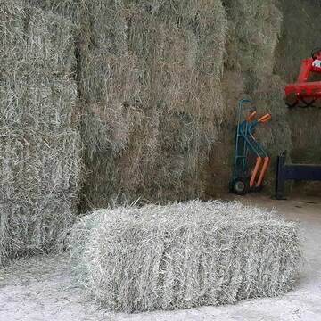
Rundballen Stroh
Elze-Esbeck
Hof Bartels
@Bartels
Stroh
Lieferant entlädt
Rundballen
Regenfrei
3 weitere...
B+
Heukleinballen (34 x 44 x 90 cm)
Marquartstein
Hacher Fahrnpoint
@Hacher-Berghof-Fahrnpoint
Heu
Kleinballen/HD-Ballen
Regenfrei
Wird verladen
1 weitere...
B+

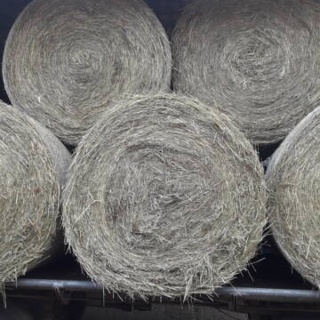
Luzerneheu 1.Schnitt
Teutschenthal
Nancy
@Haltergemeinschaft-TT
Heu
Empfänger lädt ab
Rundballen
Regenfrei
2 weitere...
B+
Leider kein Vorschaubild
Leider kein Vorschaubild
Heu - HD Ballen aus Juni 2025
Wunstorf
Heike-Wichmann-Sasse
@Heike-Wichmann-Sasse
Heu
Empfänger lädt ab
Kleinballen/HD-Ballen
Regenfrei
2 weitere...
B+
Heu Rundballen zu verkaufen
Peine
Hof-Hoppenworth
@Hof-Hoppenworth
Heu
Empfänger lädt ab
Rundballen
Regenfrei
3 weitere...
B+

Heu und Stroh /Rundballen/Quaderballen
Sandersdorf
jule13
@Jule2024
Stroh
Lieferant entlädt
Rundballen
Regenfrei
3 weitere...
B+

Das Beste für die Hufe
Mechtersen
STALL-FREIde Marketing
@STALL-FREI-Marketing
Hufschmiede und Hufpfleger in Ihrer Nähe
Leider kein Vorschaubild
Leider kein Vorschaubild
HD-Ballen Handballen Heu Heuballen Ernte 2024
Wolfsburg
Bendlin GbR
@Bendlin_GbR
Heu
Kleinballen/HD-Ballen
Regenfrei
Käufer lädt selbst
2 weitere...
B+
Leider kein Vorschaubild
Leider kein Vorschaubild
HD-Ballen Handballen Stroh Strohballen Ernte 2024
Wolfsburg
Bendlin GbR
@Bendlin_GbR
Stroh
Kleinballen/HD-Ballen
Regenfrei
Käufer lädt selbst
2 weitere...
B+

Heu in Quaderballen zu verkaufen
Bergen
Bianca Hinrichs-Schröder
@BHS1976
Futter
Empfänger lädt ab
Kleinballen/HD-Ballen
Bio
Regenfrei
2 weitere...
B+
Werde Teil von STALL-FREI.de
Verkaufe Heu, Heulage, Stroh, Einstreu oder Futter an Pferdehalter und Stallbetreiber
Deprecated: Creation of dynamic property Zend_View::$pageCount is deprecated in /var/www/stall-frei/htdocs/staging.stall-frei.de/library/vendor/shardj/zf1-future/library/Zend/View/Abstract.php on line 308
Deprecated: Creation of dynamic property Zend_View::$itemCountPerPage is deprecated in /var/www/stall-frei/htdocs/staging.stall-frei.de/library/vendor/shardj/zf1-future/library/Zend/View/Abstract.php on line 308
Deprecated: Creation of dynamic property Zend_View::$first is deprecated in /var/www/stall-frei/htdocs/staging.stall-frei.de/library/vendor/shardj/zf1-future/library/Zend/View/Abstract.php on line 308
Deprecated: Creation of dynamic property Zend_View::$current is deprecated in /var/www/stall-frei/htdocs/staging.stall-frei.de/library/vendor/shardj/zf1-future/library/Zend/View/Abstract.php on line 308
Deprecated: Creation of dynamic property Zend_View::$last is deprecated in /var/www/stall-frei/htdocs/staging.stall-frei.de/library/vendor/shardj/zf1-future/library/Zend/View/Abstract.php on line 308
Deprecated: Creation of dynamic property Zend_View::$previous is deprecated in /var/www/stall-frei/htdocs/staging.stall-frei.de/library/vendor/shardj/zf1-future/library/Zend/View/Abstract.php on line 308
Deprecated: Creation of dynamic property Zend_View::$next is deprecated in /var/www/stall-frei/htdocs/staging.stall-frei.de/library/vendor/shardj/zf1-future/library/Zend/View/Abstract.php on line 308
Deprecated: Creation of dynamic property Zend_View::$pagesInRange is deprecated in /var/www/stall-frei/htdocs/staging.stall-frei.de/library/vendor/shardj/zf1-future/library/Zend/View/Abstract.php on line 308
Deprecated: Creation of dynamic property Zend_View::$firstPageInRange is deprecated in /var/www/stall-frei/htdocs/staging.stall-frei.de/library/vendor/shardj/zf1-future/library/Zend/View/Abstract.php on line 308
Deprecated: Creation of dynamic property Zend_View::$lastPageInRange is deprecated in /var/www/stall-frei/htdocs/staging.stall-frei.de/library/vendor/shardj/zf1-future/library/Zend/View/Abstract.php on line 308
Deprecated: Creation of dynamic property Zend_View::$currentItemCount is deprecated in /var/www/stall-frei/htdocs/staging.stall-frei.de/library/vendor/shardj/zf1-future/library/Zend/View/Abstract.php on line 308
Deprecated: Creation of dynamic property Zend_View::$totalItemCount is deprecated in /var/www/stall-frei/htdocs/staging.stall-frei.de/library/vendor/shardj/zf1-future/library/Zend/View/Abstract.php on line 308
Deprecated: Creation of dynamic property Zend_View::$firstItemNumber is deprecated in /var/www/stall-frei/htdocs/staging.stall-frei.de/library/vendor/shardj/zf1-future/library/Zend/View/Abstract.php on line 308
Deprecated: Creation of dynamic property Zend_View::$lastItemNumber is deprecated in /var/www/stall-frei/htdocs/staging.stall-frei.de/library/vendor/shardj/zf1-future/library/Zend/View/Abstract.php on line 308
Deprecated: Creation of dynamic property Zend_View::$router is deprecated in /var/www/stall-frei/htdocs/staging.stall-frei.de/library/vendor/shardj/zf1-future/library/Zend/View/Abstract.php on line 308
Deprecated: Creation of dynamic property Zend_View::$urlParams is deprecated in /var/www/stall-frei/htdocs/staging.stall-frei.de/library/vendor/shardj/zf1-future/library/Zend/View/Abstract.php on line 308
Deprecated: Creation of dynamic property Zend_View::$showAds is deprecated in /var/www/stall-frei/htdocs/staging.stall-frei.de/library/vendor/shardj/zf1-future/library/Zend/View/Abstract.php on line 308
Deprecated: Creation of dynamic property Zend_View::$objectIds is deprecated in /var/www/stall-frei/htdocs/staging.stall-frei.de/library/vendor/shardj/zf1-future/library/Zend/View/Abstract.php on line 308
Deprecated: Creation of dynamic property Zend_View::$showNavbar is deprecated in /var/www/stall-frei/htdocs/staging.stall-frei.de/library/vendor/shardj/zf1-future/library/Zend/View/Abstract.php on line 308
Deprecated: Creation of dynamic property Zend_View::$showBreadcrumb is deprecated in /var/www/stall-frei/htdocs/staging.stall-frei.de/library/vendor/shardj/zf1-future/library/Zend/View/Abstract.php on line 308
Deprecated: Creation of dynamic property Zend_View::$showFooter is deprecated in /var/www/stall-frei/htdocs/staging.stall-frei.de/library/vendor/shardj/zf1-future/library/Zend/View/Abstract.php on line 308
Deprecated: Creation of dynamic property Zend_View::$showInternalAds is deprecated in /var/www/stall-frei/htdocs/staging.stall-frei.de/library/vendor/shardj/zf1-future/library/Zend/View/Abstract.php on line 308
Deprecated: Creation of dynamic property Zend_View::$blNoContent is deprecated in /var/www/stall-frei/htdocs/staging.stall-frei.de/library/vendor/shardj/zf1-future/library/Zend/View/Abstract.php on line 308
Deprecated: Creation of dynamic property Zend_View::$sMetaDesc is deprecated in /var/www/stall-frei/htdocs/staging.stall-frei.de/library/vendor/shardj/zf1-future/library/Zend/View/Abstract.php on line 308
Deprecated: Creation of dynamic property Zend_View::$useGmaps is deprecated in /var/www/stall-frei/htdocs/staging.stall-frei.de/library/vendor/shardj/zf1-future/library/Zend/View/Abstract.php on line 308
Deprecated: Creation of dynamic property Zend_View::$touches is deprecated in /var/www/stall-frei/htdocs/staging.stall-frei.de/library/vendor/shardj/zf1-future/library/Zend/View/Abstract.php on line 308
Deprecated: Creation of dynamic property Zend_View::$oProject is deprecated in /var/www/stall-frei/htdocs/staging.stall-frei.de/library/vendor/shardj/zf1-future/library/Zend/View/Abstract.php on line 308
Deprecated: Creation of dynamic property Zend_View::$pageHeadline is deprecated in /var/www/stall-frei/htdocs/staging.stall-frei.de/library/vendor/shardj/zf1-future/library/Zend/View/Abstract.php on line 308
Deprecated: Creation of dynamic property Zend_View::$disableLocationField is deprecated in /var/www/stall-frei/htdocs/staging.stall-frei.de/library/vendor/shardj/zf1-future/library/Zend/View/Abstract.php on line 308
Deprecated: Creation of dynamic property Zend_View::$isSearch is deprecated in /var/www/stall-frei/htdocs/staging.stall-frei.de/library/vendor/shardj/zf1-future/library/Zend/View/Abstract.php on line 308
Deprecated: Creation of dynamic property Zend_View::$pageTitle is deprecated in /var/www/stall-frei/htdocs/staging.stall-frei.de/library/vendor/shardj/zf1-future/library/Zend/View/Abstract.php on line 308
Deprecated: Creation of dynamic property Psf_Form_Element_Text::$class is deprecated in /var/www/stall-frei/htdocs/staging.stall-frei.de/library/vendor/shardj/zf1-future/library/Zend/Form/Element.php on line 874
Deprecated: Creation of dynamic property Psf_Form_Element_Text::$size is deprecated in /var/www/stall-frei/htdocs/staging.stall-frei.de/library/vendor/shardj/zf1-future/library/Zend/Form/Element.php on line 874
Deprecated: Creation of dynamic property Psf_Form_Element_Text::$placeholder is deprecated in /var/www/stall-frei/htdocs/staging.stall-frei.de/library/vendor/shardj/zf1-future/library/Zend/Form/Element.php on line 874
Deprecated: Creation of dynamic property Psf_Form_Element_Hidden::$class is deprecated in /var/www/stall-frei/htdocs/staging.stall-frei.de/library/vendor/shardj/zf1-future/library/Zend/Form/Element.php on line 874
Deprecated: Creation of dynamic property Psf_Form_Element_Hidden::$class is deprecated in /var/www/stall-frei/htdocs/staging.stall-frei.de/library/vendor/shardj/zf1-future/library/Zend/Form/Element.php on line 874
Deprecated: Creation of dynamic property Psf_Form_Element_Hidden::$class is deprecated in /var/www/stall-frei/htdocs/staging.stall-frei.de/library/vendor/shardj/zf1-future/library/Zend/Form/Element.php on line 874
Deprecated: Creation of dynamic property Psf_Form_Element_Hidden::$class is deprecated in /var/www/stall-frei/htdocs/staging.stall-frei.de/library/vendor/shardj/zf1-future/library/Zend/Form/Element.php on line 874
Deprecated: Creation of dynamic property Psf_Form_Element_Select::$class is deprecated in /var/www/stall-frei/htdocs/staging.stall-frei.de/library/vendor/shardj/zf1-future/library/Zend/Form/Element.php on line 874
Deprecated: Creation of dynamic property Psf_Form_Element_Select::$class is deprecated in /var/www/stall-frei/htdocs/staging.stall-frei.de/library/vendor/shardj/zf1-future/library/Zend/Form/Element.php on line 874
Deprecated: Creation of dynamic property Psf_Form_Element_Select::$class is deprecated in /var/www/stall-frei/htdocs/staging.stall-frei.de/library/vendor/shardj/zf1-future/library/Zend/Form/Element.php on line 874
Deprecated: Creation of dynamic property Psf_Form_Element_Select::$class is deprecated in /var/www/stall-frei/htdocs/staging.stall-frei.de/library/vendor/shardj/zf1-future/library/Zend/Form/Element.php on line 874
Deprecated: Creation of dynamic property Zend_View::$sort is deprecated in /var/www/stall-frei/htdocs/staging.stall-frei.de/library/vendor/shardj/zf1-future/library/Zend/View/Abstract.php on line 308
Deprecated: Creation of dynamic property Zend_View::$searchLocation is deprecated in /var/www/stall-frei/htdocs/staging.stall-frei.de/library/vendor/shardj/zf1-future/library/Zend/View/Abstract.php on line 308
Deprecated: Creation of dynamic property Zend_View::$locationHint is deprecated in /var/www/stall-frei/htdocs/staging.stall-frei.de/library/vendor/shardj/zf1-future/library/Zend/View/Abstract.php on line 308
Psf_GeoCoder_Abstract::getLocation: Heiligenstein Get Location CachedOrLive
Psf_GeoCoder_Abstract::getCachedOrLive: Heiligenstein
Psf_GeoCoder_Abstract::convertLocationResult
{"documentation":"https:\/\/opencagedata.com\/api","licenses":[{"name":"see attribution guide","url":"https:\/\/opencagedata.com\/credits"}],"results":[{"bounds":{"northeast":{"lat":49.305508,"lng":8.4184228},"southwest":{"lat":49.265508,"lng":8.3784228}},"components":{"ISO_3166-1_alpha-2":"DE","ISO_3166-1_alpha-3":"DEU","ISO_3166-2":["DE-RP"],"_category":"place","_normalized_city":"Heiligenstein","_type":"village","continent":"Europe","country":"Deutschland","country_code":"de","county":"Rhein-Pfalz-Kreis","municipality":"R\u00f6merberg-Dudenhofen","political_union":"European Union","postcode":"67354","state":"Rheinland-Pfalz","state_code":"RP","town":"Heiligenstein","village":"R\u00f6merberg"},"confidence":7,"formatted":"67354 R\u00f6merberg, Deutschland","geometry":{"lat":49.285508,"lng":8.3984228}},{"bounds":{"northeast":{"lat":50.2185068,"lng":6.6777245},"southwest":{"lat":50.2184068,"lng":6.6776245}},"components":{"ISO_3166-1_alpha-2":"DE","ISO_3166-1_alpha-3":"DEU","ISO_3166-2":["DE-RP"],"_category":"natural\/water","_normalized_city":"Gerolstein","_type":"cliff","cliff":"Heiligenstein","continent":"Europe","country":"Deutschland","country_code":"de","county":"Landkreis Vulkaneifel","municipality":"Gerolstein","political_union":"European Union","postcode":"54568","state":"Rheinland-Pfalz","state_code":"RP","town":"Gerolstein"},"confidence":9,"formatted":"Heiligenstein, 54568 Gerolstein, Deutschland","geometry":{"lat":50.2184568,"lng":6.6776745}},{"bounds":{"northeast":{"lat":48.9383605,"lng":8.3656881},"southwest":{"lat":48.935825,"lng":8.3642545}},"components":{"ISO_3166-1_alpha-2":"DE","ISO_3166-1_alpha-3":"DEU","ISO_3166-2":["DE-BW"],"_category":"agriculture","_normalized_city":"Ettlingen","_type":"farmland","continent":"Europe","country":"Deutschland","country_code":"de","county":"Landkreis Karlsruhe","farmland":"Heiligenstein","political_union":"European Union","postcode":"76275","state":"Baden-W\u00fcrttemberg","state_code":"BW","town":"Ettlingen"},"confidence":9,"formatted":"Heiligenstein, 76275 Ettlingen, Deutschland","geometry":{"lat":48.9367538,"lng":8.3648141}},{"bounds":{"northeast":{"lat":49.2868927,"lng":8.3957001},"southwest":{"lat":49.2858152,"lng":8.3940635}},"components":{"ISO_3166-1_alpha-2":"DE","ISO_3166-1_alpha-3":"DEU","ISO_3166-2":["DE-RP"],"_category":"transportation","_normalized_city":"Heiligenstein","_type":"railway","continent":"Europe","country":"Deutschland","country_code":"de","county":"Rhein-Pfalz-Kreis","municipality":"R\u00f6merberg-Dudenhofen","political_union":"European Union","postcode":"67354","railway":"Heiligenstein (Pfalz)","road":"Hinter der Kirche","state":"Rheinland-Pfalz","state_code":"RP","town":"Heiligenstein","village":"R\u00f6merberg"},"confidence":9,"formatted":"Heiligenstein (Pfalz), Hinter der Kirche, 67354 R\u00f6merberg, Deutschland","geometry":{"lat":49.2866068,"lng":8.3952657}},{"bounds":{"northeast":{"lat":49.2856264,"lng":8.3935547},"southwest":{"lat":49.2845676,"lng":8.3919572}},"components":{"ISO_3166-1_alpha-2":"DE","ISO_3166-1_alpha-3":"DEU","ISO_3166-2":["DE-RP"],"_category":"transportation","_normalized_city":"Heiligenstein","_type":"railway","continent":"Europe","country":"Deutschland","country_code":"de","county":"Rhein-Pfalz-Kreis","municipality":"R\u00f6merberg-Dudenhofen","political_union":"European Union","postcode":"67354","railway":"Heiligenstein (Pfalz)","road":"Bahnhofstra\u00dfe","state":"Rheinland-Pfalz","state_code":"RP","town":"Heiligenstein","village":"R\u00f6merberg"},"confidence":9,"formatted":"Heiligenstein (Pfalz), Bahnhofstra\u00dfe, 67354 R\u00f6merberg, Deutschland","geometry":{"lat":49.2850722,"lng":8.3927186}},{"bounds":{"northeast":{"lat":49.285906,"lng":8.394056},"southwest":{"lat":49.285806,"lng":8.393956}},"components":{"ISO_3166-1_alpha-2":"DE","ISO_3166-1_alpha-3":"DEU","ISO_3166-2":["DE-RP"],"_category":"transportation","_normalized_city":"Heiligenstein","_type":"railway","continent":"Europe","country":"Deutschland","country_code":"de","county":"Rhein-Pfalz-Kreis","municipality":"R\u00f6merberg-Dudenhofen","political_union":"European Union","postcode":"67354","railway":"Heiligenstein (Pfalz)","road":"Kneippstra\u00dfe","state":"Rheinland-Pfalz","state_code":"RP","town":"Heiligenstein","village":"R\u00f6merberg"},"confidence":9,"formatted":"Heiligenstein (Pfalz), Kneippstra\u00dfe, 67354 R\u00f6merberg, Deutschland","geometry":{"lat":49.285856,"lng":8.394006}},{"bounds":{"northeast":{"lat":50.2179596,"lng":6.6777226},"southwest":{"lat":50.2178596,"lng":6.6776226}},"components":{"ISO_3166-1_alpha-2":"DE","ISO_3166-1_alpha-3":"DEU","ISO_3166-2":["DE-RP"],"_category":"travel\/tourism","_normalized_city":"Gerolstein","_type":"information","continent":"Europe","country":"Deutschland","country_code":"de","county":"Landkreis Vulkaneifel","information":"Heiligenstein","municipality":"Gerolstein","political_union":"European Union","postcode":"54568","road":"K 34","state":"Rheinland-Pfalz","state_code":"RP","town":"Gerolstein"},"confidence":9,"formatted":"Heiligenstein, K 34, 54568 Gerolstein, Deutschland","geometry":{"lat":50.2179096,"lng":6.6776726}},{"components":{"ISO_3166-1_alpha-2":"FR","ISO_3166-1_alpha-3":"FRA","ISO_3166-2":["FR-GES","FR-6AE","FR-67"],"_category":"place","_normalized_city":"Heiligenstein","_type":"city","city":"Heiligenstein","continent":"Europe","country":"France","country_code":"fr","county":"Bas-Rhin","local_authority":"Communaut\u00e9 de communes du Pays de Barr","political_union":"European Union","postcode":"67140","state":"Grand Est","state_code":"GES"},"confidence":4,"formatted":"Heiligenstein, Bas-Rhin, France","geometry":{"lat":48.42045,"lng":7.451022}},{"components":{"ISO_3166-1_alpha-2":"FR","ISO_3166-1_alpha-3":"FRA","ISO_3166-2":["FR-GES","FR-6AE","FR-67"],"_category":"road","_normalized_city":"Heiligenstein","_type":"road","city":"Heiligenstein","continent":"Europe","country":"France","country_code":"fr","county":"Bas-Rhin","local_authority":"Communaut\u00e9 de communes du Pays de Barr","political_union":"European Union","postcode":"67140","road":"Rue du Landsberg","state":"Grand Est","state_code":"GES"},"confidence":4,"formatted":"Rue du Landsberg, 67140 Heiligenstein, France","geometry":{"lat":48.421857,"lng":7.447956}},{"components":{"ISO_3166-1_alpha-2":"FR","ISO_3166-1_alpha-3":"FRA","ISO_3166-2":["FR-GES","FR-6AE","FR-67"],"_category":"road","_normalized_city":"Heiligenstein","_type":"road","city":"Heiligenstein","continent":"Europe","country":"France","country_code":"fr","county":"Bas-Rhin","local_authority":"Communaut\u00e9 de communes du Pays de Barr","political_union":"European Union","postcode":"67140","road":"Rue de la Grange","state":"Grand Est","state_code":"GES"},"confidence":4,"formatted":"Rue de la Grange, 67140 Heiligenstein, France","geometry":{"lat":48.421203,"lng":7.448608}}],"status":{"code":200,"message":"OK"},"stay_informed":{"blog":"https:\/\/blog.opencagedata.com","mastodon":"https:\/\/en.osm.town\/@opencage"},"thanks":"For using an OpenCage API","timestamp":{"created_http":"Sat, 07 Feb 2026 03:16:36 GMT","created_unix":1770434196},"total_results":10}Array
(
[0] => stdClass Object
(
[bounds] => stdClass Object
(
[northeast] => stdClass Object
(
[lat] => 49.305508
[lng] => 8.4184228
)
[southwest] => stdClass Object
(
[lat] => 49.265508
[lng] => 8.3784228
)
)
[components] => stdClass Object
(
[ISO_3166-1_alpha-2] => DE
[ISO_3166-1_alpha-3] => DEU
[ISO_3166-2] => Array
(
[0] => DE-RP
)
[_category] => place
[_normalized_city] => Heiligenstein
[_type] => village
[continent] => Europe
[country] => Deutschland
[country_code] => de
[county] => Rhein-Pfalz-Kreis
[municipality] => Römerberg-Dudenhofen
[political_union] => European Union
[postcode] => 67354
[state] => Rheinland-Pfalz
[state_code] => RP
[town] => Heiligenstein
[village] => Römerberg
)
[confidence] => 7
[formatted] => 67354 Römerberg, Deutschland
[geometry] => stdClass Object
(
[lat] => 49.285508
[lng] => 8.3984228
)
)
[1] => stdClass Object
(
[bounds] => stdClass Object
(
[northeast] => stdClass Object
(
[lat] => 50.2185068
[lng] => 6.6777245
)
[southwest] => stdClass Object
(
[lat] => 50.2184068
[lng] => 6.6776245
)
)
[components] => stdClass Object
(
[ISO_3166-1_alpha-2] => DE
[ISO_3166-1_alpha-3] => DEU
[ISO_3166-2] => Array
(
[0] => DE-RP
)
[_category] => natural/water
[_normalized_city] => Gerolstein
[_type] => cliff
[cliff] => Heiligenstein
[continent] => Europe
[country] => Deutschland
[country_code] => de
[county] => Landkreis Vulkaneifel
[municipality] => Gerolstein
[political_union] => European Union
[postcode] => 54568
[state] => Rheinland-Pfalz
[state_code] => RP
[town] => Gerolstein
)
[confidence] => 9
[formatted] => Heiligenstein, 54568 Gerolstein, Deutschland
[geometry] => stdClass Object
(
[lat] => 50.2184568
[lng] => 6.6776745
)
)
[2] => stdClass Object
(
[bounds] => stdClass Object
(
[northeast] => stdClass Object
(
[lat] => 48.9383605
[lng] => 8.3656881
)
[southwest] => stdClass Object
(
[lat] => 48.935825
[lng] => 8.3642545
)
)
[components] => stdClass Object
(
[ISO_3166-1_alpha-2] => DE
[ISO_3166-1_alpha-3] => DEU
[ISO_3166-2] => Array
(
[0] => DE-BW
)
[_category] => agriculture
[_normalized_city] => Ettlingen
[_type] => farmland
[continent] => Europe
[country] => Deutschland
[country_code] => de
[county] => Landkreis Karlsruhe
[farmland] => Heiligenstein
[political_union] => European Union
[postcode] => 76275
[state] => Baden-Württemberg
[state_code] => BW
[town] => Ettlingen
)
[confidence] => 9
[formatted] => Heiligenstein, 76275 Ettlingen, Deutschland
[geometry] => stdClass Object
(
[lat] => 48.9367538
[lng] => 8.3648141
)
)
[3] => stdClass Object
(
[bounds] => stdClass Object
(
[northeast] => stdClass Object
(
[lat] => 49.2868927
[lng] => 8.3957001
)
[southwest] => stdClass Object
(
[lat] => 49.2858152
[lng] => 8.3940635
)
)
[components] => stdClass Object
(
[ISO_3166-1_alpha-2] => DE
[ISO_3166-1_alpha-3] => DEU
[ISO_3166-2] => Array
(
[0] => DE-RP
)
[_category] => transportation
[_normalized_city] => Heiligenstein
[_type] => railway
[continent] => Europe
[country] => Deutschland
[country_code] => de
[county] => Rhein-Pfalz-Kreis
[municipality] => Römerberg-Dudenhofen
[political_union] => European Union
[postcode] => 67354
[railway] => Heiligenstein (Pfalz)
[road] => Hinter der Kirche
[state] => Rheinland-Pfalz
[state_code] => RP
[town] => Heiligenstein
[village] => Römerberg
)
[confidence] => 9
[formatted] => Heiligenstein (Pfalz), Hinter der Kirche, 67354 Römerberg, Deutschland
[geometry] => stdClass Object
(
[lat] => 49.2866068
[lng] => 8.3952657
)
)
[4] => stdClass Object
(
[bounds] => stdClass Object
(
[northeast] => stdClass Object
(
[lat] => 49.2856264
[lng] => 8.3935547
)
[southwest] => stdClass Object
(
[lat] => 49.2845676
[lng] => 8.3919572
)
)
[components] => stdClass Object
(
[ISO_3166-1_alpha-2] => DE
[ISO_3166-1_alpha-3] => DEU
[ISO_3166-2] => Array
(
[0] => DE-RP
)
[_category] => transportation
[_normalized_city] => Heiligenstein
[_type] => railway
[continent] => Europe
[country] => Deutschland
[country_code] => de
[county] => Rhein-Pfalz-Kreis
[municipality] => Römerberg-Dudenhofen
[political_union] => European Union
[postcode] => 67354
[railway] => Heiligenstein (Pfalz)
[road] => Bahnhofstraße
[state] => Rheinland-Pfalz
[state_code] => RP
[town] => Heiligenstein
[village] => Römerberg
)
[confidence] => 9
[formatted] => Heiligenstein (Pfalz), Bahnhofstraße, 67354 Römerberg, Deutschland
[geometry] => stdClass Object
(
[lat] => 49.2850722
[lng] => 8.3927186
)
)
[5] => stdClass Object
(
[bounds] => stdClass Object
(
[northeast] => stdClass Object
(
[lat] => 49.285906
[lng] => 8.394056
)
[southwest] => stdClass Object
(
[lat] => 49.285806
[lng] => 8.393956
)
)
[components] => stdClass Object
(
[ISO_3166-1_alpha-2] => DE
[ISO_3166-1_alpha-3] => DEU
[ISO_3166-2] => Array
(
[0] => DE-RP
)
[_category] => transportation
[_normalized_city] => Heiligenstein
[_type] => railway
[continent] => Europe
[country] => Deutschland
[country_code] => de
[county] => Rhein-Pfalz-Kreis
[municipality] => Römerberg-Dudenhofen
[political_union] => European Union
[postcode] => 67354
[railway] => Heiligenstein (Pfalz)
[road] => Kneippstraße
[state] => Rheinland-Pfalz
[state_code] => RP
[town] => Heiligenstein
[village] => Römerberg
)
[confidence] => 9
[formatted] => Heiligenstein (Pfalz), Kneippstraße, 67354 Römerberg, Deutschland
[geometry] => stdClass Object
(
[lat] => 49.285856
[lng] => 8.394006
)
)
[6] => stdClass Object
(
[bounds] => stdClass Object
(
[northeast] => stdClass Object
(
[lat] => 50.2179596
[lng] => 6.6777226
)
[southwest] => stdClass Object
(
[lat] => 50.2178596
[lng] => 6.6776226
)
)
[components] => stdClass Object
(
[ISO_3166-1_alpha-2] => DE
[ISO_3166-1_alpha-3] => DEU
[ISO_3166-2] => Array
(
[0] => DE-RP
)
[_category] => travel/tourism
[_normalized_city] => Gerolstein
[_type] => information
[continent] => Europe
[country] => Deutschland
[country_code] => de
[county] => Landkreis Vulkaneifel
[information] => Heiligenstein
[municipality] => Gerolstein
[political_union] => European Union
[postcode] => 54568
[road] => K 34
[state] => Rheinland-Pfalz
[state_code] => RP
[town] => Gerolstein
)
[confidence] => 9
[formatted] => Heiligenstein, K 34, 54568 Gerolstein, Deutschland
[geometry] => stdClass Object
(
[lat] => 50.2179096
[lng] => 6.6776726
)
)
[7] => stdClass Object
(
[components] => stdClass Object
(
[ISO_3166-1_alpha-2] => FR
[ISO_3166-1_alpha-3] => FRA
[ISO_3166-2] => Array
(
[0] => FR-GES
[1] => FR-6AE
[2] => FR-67
)
[_category] => place
[_normalized_city] => Heiligenstein
[_type] => city
[city] => Heiligenstein
[continent] => Europe
[country] => France
[country_code] => fr
[county] => Bas-Rhin
[local_authority] => Communauté de communes du Pays de Barr
[political_union] => European Union
[postcode] => 67140
[state] => Grand Est
[state_code] => GES
)
[confidence] => 4
[formatted] => Heiligenstein, Bas-Rhin, France
[geometry] => stdClass Object
(
[lat] => 48.42045
[lng] => 7.451022
)
)
[8] => stdClass Object
(
[components] => stdClass Object
(
[ISO_3166-1_alpha-2] => FR
[ISO_3166-1_alpha-3] => FRA
[ISO_3166-2] => Array
(
[0] => FR-GES
[1] => FR-6AE
[2] => FR-67
)
[_category] => road
[_normalized_city] => Heiligenstein
[_type] => road
[city] => Heiligenstein
[continent] => Europe
[country] => France
[country_code] => fr
[county] => Bas-Rhin
[local_authority] => Communauté de communes du Pays de Barr
[political_union] => European Union
[postcode] => 67140
[road] => Rue du Landsberg
[state] => Grand Est
[state_code] => GES
)
[confidence] => 4
[formatted] => Rue du Landsberg, 67140 Heiligenstein, France
[geometry] => stdClass Object
(
[lat] => 48.421857
[lng] => 7.447956
)
)
[9] => stdClass Object
(
[components] => stdClass Object
(
[ISO_3166-1_alpha-2] => FR
[ISO_3166-1_alpha-3] => FRA
[ISO_3166-2] => Array
(
[0] => FR-GES
[1] => FR-6AE
[2] => FR-67
)
[_category] => road
[_normalized_city] => Heiligenstein
[_type] => road
[city] => Heiligenstein
[continent] => Europe
[country] => France
[country_code] => fr
[county] => Bas-Rhin
[local_authority] => Communauté de communes du Pays de Barr
[political_union] => European Union
[postcode] => 67140
[road] => Rue de la Grange
[state] => Grand Est
[state_code] => GES
)
[confidence] => 4
[formatted] => Rue de la Grange, 67140 Heiligenstein, France
[geometry] => stdClass Object
(
[lat] => 48.421203
[lng] => 7.448608
)
)
)
Psf_GeoCoder_OpenCageData::getKeyMap: 0
stdClass Object
(
    [bounds] => stdClass Object
        (
            [northeast] => stdClass Object
                (
                    [lat] => 49.305508
                    [lng] => 8.4184228
                )

            [southwest] => stdClass Object
                (
                    [lat] => 49.265508
                    [lng] => 8.3784228
                )

        )

    [components] => stdClass Object
        (
            [ISO_3166-1_alpha-2] => DE
            [ISO_3166-1_alpha-3] => DEU
            [ISO_3166-2] => Array
                (
                    [0] => DE-RP
                )

            [_category] => place
            [_normalized_city] => Heiligenstein
            [_type] => village
            [continent] => Europe
            [country] => Deutschland
            [country_code] => de
            [county] => Rhein-Pfalz-Kreis
            [municipality] => Römerberg-Dudenhofen
            [political_union] => European Union
            [postcode] => 67354
            [state] => Rheinland-Pfalz
            [state_code] => RP
            [town] => Heiligenstein
            [village] => Römerberg
        )

    [confidence] => 7
    [formatted] => 67354 Römerberg, Deutschland
    [geometry] => stdClass Object
        (
            [lat] => 49.285508
            [lng] => 8.3984228
        )

)
Psf_GeoCoder_OpenCageData::getCounty: Rhein-Pfalz-Kreis
Psf_GeoCoder_OpenCageData::addMissingData REFETCH!
Array
(
    [address] => 67354 Römerberg, Deutschland
    [type] => village
    [street] =>
    [city] => Heiligenstein
    [county] => Rhein-Pfalz-Kreis
    [state] => Rheinland-Pfalz
    [zip] => 67354
    [country] => Deutschland
    [suburb] =>
    [countrycode] => de
    [latitude] => 49.285508
    [longitude] => 8.3984228
    [accuracy] => 1
    [confidence] => 7
    [bounds] => stdClass Object
        (
            [northeast] => stdClass Object
                (
                    [lat] => 49.305508
                    [lng] => 8.4184228
                )

            [southwest] => stdClass Object
                (
                    [lat] => 49.265508
                    [lng] => 8.3784228
                )

        )

)
reformat!
Array
(
    [address] => 67354 Heiligenstein
    [type] => village
    [street] =>
    [city] => Heiligenstein
    [county] => Rhein-Pfalz-Kreis
    [state] => Rheinland-Pfalz
    [zip] => 67354
    [country] => Deutschland
    [suburb] =>
    [countrycode] => de
    [latitude] => 49.285508
    [longitude] => 8.3984228
    [accuracy] => 1
    [confidence] => 7
    [bounds] => stdClass Object
        (
            [northeast] => stdClass Object
                (
                    [lat] => 49.305508
                    [lng] => 8.4184228
                )

            [southwest] => stdClass Object
                (
                    [lat] => 49.265508
                    [lng] => 8.3784228
                )

        )

    [place] => 67354 Heiligenstein, Rheinland-Pfalz
    [hash] => 26d843faf1bf2be896fcf9c5f0325549
)
Psf_GeoCoder_OpenCageData::getKeyMap: 1
stdClass Object
(
    [bounds] => stdClass Object
        (
            [northeast] => stdClass Object
                (
                    [lat] => 50.2185068
                    [lng] => 6.6777245
                )

            [southwest] => stdClass Object
                (
                    [lat] => 50.2184068
                    [lng] => 6.6776245
                )

        )

    [components] => stdClass Object
        (
            [ISO_3166-1_alpha-2] => DE
            [ISO_3166-1_alpha-3] => DEU
            [ISO_3166-2] => Array
                (
                    [0] => DE-RP
                )

            [_category] => natural/water
            [_normalized_city] => Gerolstein
            [_type] => cliff
            [cliff] => Heiligenstein
            [continent] => Europe
            [country] => Deutschland
            [country_code] => de
            [county] => Landkreis Vulkaneifel
            [municipality] => Gerolstein
            [political_union] => European Union
            [postcode] => 54568
            [state] => Rheinland-Pfalz
            [state_code] => RP
            [town] => Gerolstein
        )

    [confidence] => 9
    [formatted] => Heiligenstein, 54568 Gerolstein, Deutschland
    [geometry] => stdClass Object
        (
            [lat] => 50.2184568
            [lng] => 6.6776745
        )

)
Psf_GeoCoder_OpenCageData::getCounty: Vulkaneifel
Psf_GeoCoder_OpenCageData::addMissingData REFETCH!
Array
(
    [address] => Heiligenstein, 54568 Gerolstein, Deutschland
    [type] => cliff
    [street] =>
    [city] => Gerolstein
    [county] => Vulkaneifel
    [state] => Rheinland-Pfalz
    [zip] => 54568
    [country] => Deutschland
    [suburb] =>
    [countrycode] => de
    [latitude] => 50.2184568
    [longitude] => 6.6776745
    [accuracy] => 1
    [confidence] => 9
    [bounds] => stdClass Object
        (
            [northeast] => stdClass Object
                (
                    [lat] => 50.2185068
                    [lng] => 6.6777245
                )

            [southwest] => stdClass Object
                (
                    [lat] => 50.2184068
                    [lng] => 6.6776245
                )

        )

)
reformat!
Array
(
    [address] => Heiligenstein, 54568 Gerolstein, Deutschland
    [type] => cliff
    [street] =>
    [city] => Gerolstein
    [county] => Vulkaneifel
    [state] => Rheinland-Pfalz
    [zip] => 54568
    [country] => Deutschland
    [suburb] =>
    [countrycode] => de
    [latitude] => 50.2184568
    [longitude] => 6.6776745
    [accuracy] => 1
    [confidence] => 9
    [bounds] => stdClass Object
        (
            [northeast] => stdClass Object
                (
                    [lat] => 50.2185068
                    [lng] => 6.6777245
                )

            [southwest] => stdClass Object
                (
                    [lat] => 50.2184068
                    [lng] => 6.6776245
                )

        )

    [place] => 54568 Gerolstein, Rheinland-Pfalz
    [hash] => be6f60c7e30348a4e8b519ca15c6e0b3
)
Psf_GeoCoder_OpenCageData::getKeyMap: 2
stdClass Object
(
    [bounds] => stdClass Object
        (
            [northeast] => stdClass Object
                (
                    [lat] => 48.9383605
                    [lng] => 8.3656881
                )

            [southwest] => stdClass Object
                (
                    [lat] => 48.935825
                    [lng] => 8.3642545
                )

        )

    [components] => stdClass Object
        (
            [ISO_3166-1_alpha-2] => DE
            [ISO_3166-1_alpha-3] => DEU
            [ISO_3166-2] => Array
                (
                    [0] => DE-BW
                )

            [_category] => agriculture
            [_normalized_city] => Ettlingen
            [_type] => farmland
            [continent] => Europe
            [country] => Deutschland
            [country_code] => de
            [county] => Landkreis Karlsruhe
            [farmland] => Heiligenstein
            [political_union] => European Union
            [postcode] => 76275
            [state] => Baden-Württemberg
            [state_code] => BW
            [town] => Ettlingen
        )

    [confidence] => 9
    [formatted] => Heiligenstein, 76275 Ettlingen, Deutschland
    [geometry] => stdClass Object
        (
            [lat] => 48.9367538
            [lng] => 8.3648141
        )

)
Psf_GeoCoder_OpenCageData::getCounty: Karlsruhe
Psf_GeoCoder_OpenCageData::addMissingData REFETCH!
Array
(
    [address] => Heiligenstein, 76275 Ettlingen, Deutschland
    [type] => farmland
    [street] =>
    [city] => Ettlingen
    [county] => Karlsruhe
    [state] => Baden-Württemberg
    [zip] => 76275
    [country] => Deutschland
    [suburb] =>
    [countrycode] => de
    [latitude] => 48.9367538
    [longitude] => 8.3648141
    [accuracy] => 1
    [confidence] => 9
    [bounds] => stdClass Object
        (
            [northeast] => stdClass Object
                (
                    [lat] => 48.9383605
                    [lng] => 8.3656881
                )

            [southwest] => stdClass Object
                (
                    [lat] => 48.935825
                    [lng] => 8.3642545
                )

        )

)
reformat!
Array
(
    [address] => Heiligenstein, 76275 Ettlingen, Deutschland
    [type] => farmland
    [street] =>
    [city] => Ettlingen
    [county] => Karlsruhe
    [state] => Baden-Württemberg
    [zip] => 76275
    [country] => Deutschland
    [suburb] =>
    [countrycode] => de
    [latitude] => 48.9367538
    [longitude] => 8.3648141
    [accuracy] => 1
    [confidence] => 9
    [bounds] => stdClass Object
        (
            [northeast] => stdClass Object
                (
                    [lat] => 48.9383605
                    [lng] => 8.3656881
                )

            [southwest] => stdClass Object
                (
                    [lat] => 48.935825
                    [lng] => 8.3642545
                )

        )

    [place] => 76275 Ettlingen, Baden-Württemberg
    [hash] => 51056d86e7f186500b2e9ca0d199eaf0
)
Psf_GeoCoder_OpenCageData::getKeyMap: 3
stdClass Object
(
    [bounds] => stdClass Object
        (
            [northeast] => stdClass Object
                (
                    [lat] => 49.2868927
                    [lng] => 8.3957001
                )

            [southwest] => stdClass Object
                (
                    [lat] => 49.2858152
                    [lng] => 8.3940635
                )

        )

    [components] => stdClass Object
        (
            [ISO_3166-1_alpha-2] => DE
            [ISO_3166-1_alpha-3] => DEU
            [ISO_3166-2] => Array
                (
                    [0] => DE-RP
                )

            [_category] => transportation
            [_normalized_city] => Heiligenstein
            [_type] => railway
            [continent] => Europe
            [country] => Deutschland
            [country_code] => de
            [county] => Rhein-Pfalz-Kreis
            [municipality] => Römerberg-Dudenhofen
            [political_union] => European Union
            [postcode] => 67354
            [railway] => Heiligenstein (Pfalz)
            [road] => Hinter der Kirche
            [state] => Rheinland-Pfalz
            [state_code] => RP
            [town] => Heiligenstein
            [village] => Römerberg
        )

    [confidence] => 9
    [formatted] => Heiligenstein (Pfalz), Hinter der Kirche, 67354 Römerberg, Deutschland
    [geometry] => stdClass Object
        (
            [lat] => 49.2866068
            [lng] => 8.3952657
        )

)
Psf_GeoCoder_OpenCageData::getCounty: Rhein-Pfalz-Kreis
Psf_GeoCoder_OpenCageData::addMissingData REFETCH!
Array
(
    [address] => Heiligenstein (Pfalz), Hinter der Kirche, 67354 Römerberg, Deutschland
    [type] => railway
    [street] => Hinter der Kirche
    [city] => Heiligenstein
    [county] => Rhein-Pfalz-Kreis
    [state] => Rheinland-Pfalz
    [zip] => 67354
    [country] => Deutschland
    [suburb] =>
    [countrycode] => de
    [latitude] => 49.2866068
    [longitude] => 8.3952657
    [accuracy] => 1
    [confidence] => 9
    [bounds] => stdClass Object
        (
            [northeast] => stdClass Object
                (
                    [lat] => 49.2868927
                    [lng] => 8.3957001
                )

            [southwest] => stdClass Object
                (
                    [lat] => 49.2858152
                    [lng] => 8.3940635
                )

        )

)
reformat!
Array
(
    [address] => Heiligenstein (Pfalz), Hinter der Kirche, 67354 Römerberg, Deutschland
    [type] => railway
    [street] => Hinter der Kirche
    [city] => Heiligenstein
    [county] => Rhein-Pfalz-Kreis
    [state] => Rheinland-Pfalz
    [zip] => 67354
    [country] => Deutschland
    [suburb] =>
    [countrycode] => de
    [latitude] => 49.2866068
    [longitude] => 8.3952657
    [accuracy] => 1
    [confidence] => 9
    [bounds] => stdClass Object
        (
            [northeast] => stdClass Object
                (
                    [lat] => 49.2868927
                    [lng] => 8.3957001
                )

            [southwest] => stdClass Object
                (
                    [lat] => 49.2858152
                    [lng] => 8.3940635
                )

        )

    [place] => Hinter der Kirche, 67354 Heiligenstein, Rheinland-Pfalz
    [hash] => 00418276efd0f0c7188af7ac24e49714
)
Psf_GeoCoder_OpenCageData::getKeyMap: 4
stdClass Object
(
    [bounds] => stdClass Object
        (
            [northeast] => stdClass Object
                (
                    [lat] => 49.2856264
                    [lng] => 8.3935547
                )

            [southwest] => stdClass Object
                (
                    [lat] => 49.2845676
                    [lng] => 8.3919572
                )

        )

    [components] => stdClass Object
        (
            [ISO_3166-1_alpha-2] => DE
            [ISO_3166-1_alpha-3] => DEU
            [ISO_3166-2] => Array
                (
                    [0] => DE-RP
                )

            [_category] => transportation
            [_normalized_city] => Heiligenstein
            [_type] => railway
            [continent] => Europe
            [country] => Deutschland
            [country_code] => de
            [county] => Rhein-Pfalz-Kreis
            [municipality] => Römerberg-Dudenhofen
            [political_union] => European Union
            [postcode] => 67354
            [railway] => Heiligenstein (Pfalz)
            [road] => Bahnhofstraße
            [state] => Rheinland-Pfalz
            [state_code] => RP
            [town] => Heiligenstein
            [village] => Römerberg
        )

    [confidence] => 9
    [formatted] => Heiligenstein (Pfalz), Bahnhofstraße, 67354 Römerberg, Deutschland
    [geometry] => stdClass Object
        (
            [lat] => 49.2850722
            [lng] => 8.3927186
        )

)
Psf_GeoCoder_OpenCageData::getCounty: Rhein-Pfalz-Kreis
Psf_GeoCoder_OpenCageData::addMissingData REFETCH!
Array
(
    [address] => Heiligenstein (Pfalz), Bahnhofstraße, 67354 Römerberg, Deutschland
    [type] => railway
    [street] => Bahnhofstraße
    [city] => Heiligenstein
    [county] => Rhein-Pfalz-Kreis
    [state] => Rheinland-Pfalz
    [zip] => 67354
    [country] => Deutschland
    [suburb] =>
    [countrycode] => de
    [latitude] => 49.2850722
    [longitude] => 8.3927186
    [accuracy] => 1
    [confidence] => 9
    [bounds] => stdClass Object
        (
            [northeast] => stdClass Object
                (
                    [lat] => 49.2856264
                    [lng] => 8.3935547
                )

            [southwest] => stdClass Object
                (
                    [lat] => 49.2845676
                    [lng] => 8.3919572
                )

        )

)
reformat!
Array
(
    [address] => Heiligenstein (Pfalz), Bahnhofstraße, 67354 Römerberg, Deutschland
    [type] => railway
    [street] => Bahnhofstraße
    [city] => Heiligenstein
    [county] => Rhein-Pfalz-Kreis
    [state] => Rheinland-Pfalz
    [zip] => 67354
    [country] => Deutschland
    [suburb] =>
    [countrycode] => de
    [latitude] => 49.2850722
    [longitude] => 8.3927186
    [accuracy] => 1
    [confidence] => 9
    [bounds] => stdClass Object
        (
            [northeast] => stdClass Object
                (
                    [lat] => 49.2856264
                    [lng] => 8.3935547
                )

            [southwest] => stdClass Object
                (
                    [lat] => 49.2845676
                    [lng] => 8.3919572
                )

        )

    [place] => Bahnhofstraße, 67354 Heiligenstein, Rheinland-Pfalz
    [hash] => 92b71a5edbb1edc80fae93b54c04701b
)
Psf_GeoCoder_OpenCageData::getKeyMap: 5
stdClass Object
(
    [bounds] => stdClass Object
        (
            [northeast] => stdClass Object
                (
                    [lat] => 49.285906
                    [lng] => 8.394056
                )

            [southwest] => stdClass Object
                (
                    [lat] => 49.285806
                    [lng] => 8.393956
                )

        )

    [components] => stdClass Object
        (
            [ISO_3166-1_alpha-2] => DE
            [ISO_3166-1_alpha-3] => DEU
            [ISO_3166-2] => Array
                (
                    [0] => DE-RP
                )

            [_category] => transportation
            [_normalized_city] => Heiligenstein
            [_type] => railway
            [continent] => Europe
            [country] => Deutschland
            [country_code] => de
            [county] => Rhein-Pfalz-Kreis
            [municipality] => Römerberg-Dudenhofen
            [political_union] => European Union
            [postcode] => 67354
            [railway] => Heiligenstein (Pfalz)
            [road] => Kneippstraße
            [state] => Rheinland-Pfalz
            [state_code] => RP
            [town] => Heiligenstein
            [village] => Römerberg
        )

    [confidence] => 9
    [formatted] => Heiligenstein (Pfalz), Kneippstraße, 67354 Römerberg, Deutschland
    [geometry] => stdClass Object
        (
            [lat] => 49.285856
            [lng] => 8.394006
        )

)
Psf_GeoCoder_OpenCageData::getCounty: Rhein-Pfalz-Kreis
Psf_GeoCoder_OpenCageData::addMissingData REFETCH!
Array
(
    [address] => Heiligenstein (Pfalz), Kneippstraße, 67354 Römerberg, Deutschland
    [type] => railway
    [street] => Kneippstraße
    [city] => Heiligenstein
    [county] => Rhein-Pfalz-Kreis
    [state] => Rheinland-Pfalz
    [zip] => 67354
    [country] => Deutschland
    [suburb] =>
    [countrycode] => de
    [latitude] => 49.285856
    [longitude] => 8.394006
    [accuracy] => 1
    [confidence] => 9
    [bounds] => stdClass Object
        (
            [northeast] => stdClass Object
                (
                    [lat] => 49.285906
                    [lng] => 8.394056
                )

            [southwest] => stdClass Object
                (
                    [lat] => 49.285806
                    [lng] => 8.393956
                )

        )

)
reformat!
Array
(
    [address] => Heiligenstein (Pfalz), Kneippstraße, 67354 Römerberg, Deutschland
    [type] => railway
    [street] => Kneippstraße
    [city] => Heiligenstein
    [county] => Rhein-Pfalz-Kreis
    [state] => Rheinland-Pfalz
    [zip] => 67354
    [country] => Deutschland
    [suburb] =>
    [countrycode] => de
    [latitude] => 49.285856
    [longitude] => 8.394006
    [accuracy] => 1
    [confidence] => 9
    [bounds] => stdClass Object
        (
            [northeast] => stdClass Object
                (
                    [lat] => 49.285906
                    [lng] => 8.394056
                )

            [southwest] => stdClass Object
                (
                    [lat] => 49.285806
                    [lng] => 8.393956
                )

        )

    [place] => Kneippstraße, 67354 Heiligenstein, Rheinland-Pfalz
    [hash] => f5efbbcc9fbae7ebc7f33f209c79219d
)
Psf_GeoCoder_OpenCageData::getKeyMap: 6
stdClass Object
(
    [bounds] => stdClass Object
        (
            [northeast] => stdClass Object
                (
                    [lat] => 50.2179596
                    [lng] => 6.6777226
                )

            [southwest] => stdClass Object
                (
                    [lat] => 50.2178596
                    [lng] => 6.6776226
                )

        )

    [components] => stdClass Object
        (
            [ISO_3166-1_alpha-2] => DE
            [ISO_3166-1_alpha-3] => DEU
            [ISO_3166-2] => Array
                (
                    [0] => DE-RP
                )

            [_category] => travel/tourism
            [_normalized_city] => Gerolstein
            [_type] => information
            [continent] => Europe
            [country] => Deutschland
            [country_code] => de
            [county] => Landkreis Vulkaneifel
            [information] => Heiligenstein
            [municipality] => Gerolstein
            [political_union] => European Union
            [postcode] => 54568
            [road] => K 34
            [state] => Rheinland-Pfalz
            [state_code] => RP
            [town] => Gerolstein
        )

    [confidence] => 9
    [formatted] => Heiligenstein, K 34, 54568 Gerolstein, Deutschland
    [geometry] => stdClass Object
        (
            [lat] => 50.2179096
            [lng] => 6.6776726
        )

)
Psf_GeoCoder_OpenCageData::getCounty: Vulkaneifel
Psf_GeoCoder_OpenCageData::addMissingData REFETCH!
Array
(
    [address] => Heiligenstein, K 34, 54568 Gerolstein, Deutschland
    [type] => information
    [street] => K 34
    [city] => Gerolstein
    [county] => Vulkaneifel
    [state] => Rheinland-Pfalz
    [zip] => 54568
    [country] => Deutschland
    [suburb] =>
    [countrycode] => de
    [latitude] => 50.2179096
    [longitude] => 6.6776726
    [accuracy] => 1
    [confidence] => 9
    [bounds] => stdClass Object
        (
            [northeast] => stdClass Object
                (
                    [lat] => 50.2179596
                    [lng] => 6.6777226
                )

            [southwest] => stdClass Object
                (
                    [lat] => 50.2178596
                    [lng] => 6.6776226
                )

        )

)
reformat!
Array
(
    [address] => Heiligenstein, K 34, 54568 Gerolstein, Deutschland
    [type] => information
    [street] => K 34
    [city] => Gerolstein
    [county] => Vulkaneifel
    [state] => Rheinland-Pfalz
    [zip] => 54568
    [country] => Deutschland
    [suburb] =>
    [countrycode] => de
    [latitude] => 50.2179096
    [longitude] => 6.6776726
    [accuracy] => 1
    [confidence] => 9
    [bounds] => stdClass Object
        (
            [northeast] => stdClass Object
                (
                    [lat] => 50.2179596
                    [lng] => 6.6777226
                )

            [southwest] => stdClass Object
                (
                    [lat] => 50.2178596
                    [lng] => 6.6776226
                )

        )

    [place] => K 34, 54568 Gerolstein, Rheinland-Pfalz
    [hash] => 841f6afe33f49073436f528bb5142386
)
Psf_GeoCoder_OpenCageData::getKeyMap: 7
stdClass Object
(
    [components] => stdClass Object
        (
            [ISO_3166-1_alpha-2] => FR
            [ISO_3166-1_alpha-3] => FRA
            [ISO_3166-2] => Array
                (
                    [0] => FR-GES
                    [1] => FR-6AE
                    [2] => FR-67
                )

            [_category] => place
            [_normalized_city] => Heiligenstein
            [_type] => city
            [city] => Heiligenstein
            [continent] => Europe
            [country] => France
            [country_code] => fr
            [county] => Bas-Rhin
            [local_authority] => Communauté de communes du Pays de Barr
            [political_union] => European Union
            [postcode] => 67140
            [state] => Grand Est
            [state_code] => GES
        )

    [confidence] => 4
    [formatted] => Heiligenstein, Bas-Rhin, France
    [geometry] => stdClass Object
        (
            [lat] => 48.42045
            [lng] => 7.451022
        )

)
Psf_GeoCoder_OpenCageData::getCounty: Bas-Rhin
Psf_GeoCoder_OpenCageData::addMissingData REFETCH!
Array
(
    [address] => Heiligenstein, Bas-Rhin, France
    [type] => city
    [street] =>
    [city] => Heiligenstein
    [county] => Bas-Rhin
    [state] => Grand Est
    [zip] => 67140
    [country] => France
    [suburb] =>
    [countrycode] => fr
    [latitude] => 48.42045
    [longitude] => 7.451022
    [accuracy] => 1
    [confidence] => 4
    [bounds] =>
)
reformat!
Array
(
    [address] => Heiligenstein, Bas-Rhin, France
    [type] => city
    [street] =>
    [city] => Heiligenstein
    [county] => Bas-Rhin
    [state] => Grand Est
    [zip] => 67140
    [country] => France
    [suburb] =>
    [countrycode] => fr
    [latitude] => 48.42045
    [longitude] => 7.451022
    [accuracy] => 1
    [confidence] => 4
    [bounds] =>
    [place] => 67140 Heiligenstein, Grand Est
    [hash] => 6bf86e3e32256633680cf8cffb369024
)
Psf_GeoCoder_OpenCageData::getKeyMap: 8
stdClass Object
(
    [components] => stdClass Object
        (
            [ISO_3166-1_alpha-2] => FR
            [ISO_3166-1_alpha-3] => FRA
            [ISO_3166-2] => Array
                (
                    [0] => FR-GES
                    [1] => FR-6AE
                    [2] => FR-67
                )

            [_category] => road
            [_normalized_city] => Heiligenstein
            [_type] => road
            [city] => Heiligenstein
            [continent] => Europe
            [country] => France
            [country_code] => fr
            [county] => Bas-Rhin
            [local_authority] => Communauté de communes du Pays de Barr
            [political_union] => European Union
            [postcode] => 67140
            [road] => Rue du Landsberg
            [state] => Grand Est
            [state_code] => GES
        )

    [confidence] => 4
    [formatted] => Rue du Landsberg, 67140 Heiligenstein, France
    [geometry] => stdClass Object
        (
            [lat] => 48.421857
            [lng] => 7.447956
        )

)
Psf_GeoCoder_OpenCageData::getCounty: Bas-Rhin
Psf_GeoCoder_OpenCageData::addMissingData REFETCH!
Array
(
    [address] => Rue du Landsberg, 67140 Heiligenstein, France
    [type] => road
    [street] => Rue du Landsberg
    [city] => Heiligenstein
    [county] => Bas-Rhin
    [state] => Grand Est
    [zip] => 67140
    [country] => France
    [suburb] =>
    [countrycode] => fr
    [latitude] => 48.421857
    [longitude] => 7.447956
    [accuracy] => 1
    [confidence] => 4
    [bounds] =>
)
reformat!
Array
(
    [address] => Rue du Landsberg, 67140 Heiligenstein, France
    [type] => road
    [street] => Rue du Landsberg
    [city] => Heiligenstein
    [county] => Bas-Rhin
    [state] => Grand Est
    [zip] => 67140
    [country] => France
    [suburb] =>
    [countrycode] => fr
    [latitude] => 48.421857
    [longitude] => 7.447956
    [accuracy] => 1
    [confidence] => 4
    [bounds] =>
    [place] => Rue du Landsberg, 67140 Heiligenstein, Grand Est
    [hash] => c7a1ec075b4c700e4c8d317a753cac09
)
Psf_GeoCoder_OpenCageData::getKeyMap: 9
stdClass Object
(
    [components] => stdClass Object
        (
            [ISO_3166-1_alpha-2] => FR
            [ISO_3166-1_alpha-3] => FRA
            [ISO_3166-2] => Array
                (
                    [0] => FR-GES
                    [1] => FR-6AE
                    [2] => FR-67
                )

            [_category] => road
            [_normalized_city] => Heiligenstein
            [_type] => road
            [city] => Heiligenstein
            [continent] => Europe
            [country] => France
            [country_code] => fr
            [county] => Bas-Rhin
            [local_authority] => Communauté de communes du Pays de Barr
            [political_union] => European Union
            [postcode] => 67140
            [road] => Rue de la Grange
            [state] => Grand Est
            [state_code] => GES
        )

    [confidence] => 4
    [formatted] => Rue de la Grange, 67140 Heiligenstein, France
    [geometry] => stdClass Object
        (
            [lat] => 48.421203
            [lng] => 7.448608
        )

)
Psf_GeoCoder_OpenCageData::getCounty: Bas-Rhin
Psf_GeoCoder_OpenCageData::addMissingData REFETCH!
Array
(
    [address] => Rue de la Grange, 67140 Heiligenstein, France
    [type] => road
    [street] => Rue de la Grange
    [city] => Heiligenstein
    [county] => Bas-Rhin
    [state] => Grand Est
    [zip] => 67140
    [country] => France
    [suburb] =>
    [countrycode] => fr
    [latitude] => 48.421203
    [longitude] => 7.448608
    [accuracy] => 1
    [confidence] => 4
    [bounds] =>
)
reformat!
Array
(
    [address] => Rue de la Grange, 67140 Heiligenstein, France
    [type] => road
    [street] => Rue de la Grange
    [city] => Heiligenstein
    [county] => Bas-Rhin
    [state] => Grand Est
    [zip] => 67140
    [country] => France
    [suburb] =>
    [countrycode] => fr
    [latitude] => 48.421203
    [longitude] => 7.448608
    [accuracy] => 1
    [confidence] => 4
    [bounds] =>
    [place] => Rue de la Grange, 67140 Heiligenstein, Grand Est
    [hash] => 32a3688b999f2ab8db954f7a5896ff85
)
Deprecated: Creation of dynamic property Zend_View::$locationHintStyle is deprecated in /var/www/stall-frei/htdocs/staging.stall-frei.de/library/vendor/shardj/zf1-future/library/Zend/View/Abstract.php on line 308
Deprecated: Creation of dynamic property Zend_View::$adGeoLocation is deprecated in /var/www/stall-frei/htdocs/staging.stall-frei.de/library/vendor/shardj/zf1-future/library/Zend/View/Abstract.php on line 308
Deprecated: Creation of dynamic property Zend_View::$recordCount is deprecated in /var/www/stall-frei/htdocs/staging.stall-frei.de/library/vendor/shardj/zf1-future/library/Zend/View/Abstract.php on line 308
Deprecated: Creation of dynamic property Zend_View::$paginationParams is deprecated in /var/www/stall-frei/htdocs/staging.stall-frei.de/library/vendor/shardj/zf1-future/library/Zend/View/Abstract.php on line 308
Deprecated: Creation of dynamic property Zend_View::$objectPaginator is deprecated in /var/www/stall-frei/htdocs/staging.stall-frei.de/library/vendor/shardj/zf1-future/library/Zend/View/Abstract.php on line 308
Deprecated: Creation of dynamic property Zend_View::$featuredObjects is deprecated in /var/www/stall-frei/htdocs/staging.stall-frei.de/library/vendor/shardj/zf1-future/library/Zend/View/Abstract.php on line 308
Deprecated: Creation of dynamic property Zend_View::$hints is deprecated in /var/www/stall-frei/htdocs/staging.stall-frei.de/library/vendor/shardj/zf1-future/library/Zend/View/Abstract.php on line 308
Deprecated: Creation of dynamic property Zend_View::$attributeHints is deprecated in /var/www/stall-frei/htdocs/staging.stall-frei.de/library/vendor/shardj/zf1-future/library/Zend/View/Abstract.php on line 308
Deprecated: Creation of dynamic property Zend_View::$oSearchForm is deprecated in /var/www/stall-frei/htdocs/staging.stall-frei.de/library/vendor/shardj/zf1-future/library/Zend/View/Abstract.php on line 308