Deprecated: Creation of dynamic property Zend_View::$sMode is deprecated in /var/www/stall-frei/htdocs/staging.stall-frei.de/library/vendor/shardj/zf1-future/library/Zend/View/Abstract.php on line 308
Heu, Stroh oder Futter
Gesucht wird in "Uder, Thüringen, Deutschland"
95 Einträge
Deprecated: Creation of dynamic property Zend_View::$listObjects is deprecated in /var/www/stall-frei/htdocs/staging.stall-frei.de/library/vendor/shardj/zf1-future/library/Zend/View/Abstract.php on line 308
Deprecated: Creation of dynamic property Zend_View::$listMode is deprecated in /var/www/stall-frei/htdocs/staging.stall-frei.de/library/vendor/shardj/zf1-future/library/Zend/View/Abstract.php on line 308
Deprecated: Creation of dynamic property Zend_View::$renderedObjects is deprecated in /var/www/stall-frei/htdocs/staging.stall-frei.de/library/vendor/shardj/zf1-future/library/Zend/View/Abstract.php on line 308
Deprecated: Creation of dynamic property Zend_View::$index is deprecated in /var/www/stall-frei/htdocs/staging.stall-frei.de/library/vendor/shardj/zf1-future/library/Zend/View/Abstract.php on line 308
Deprecated: Creation of dynamic property Zend_View::$displayMode is deprecated in /var/www/stall-frei/htdocs/staging.stall-frei.de/library/vendor/shardj/zf1-future/library/Zend/View/Abstract.php on line 308
Deprecated: Creation of dynamic property Zend_View::$remarketingIds is deprecated in /var/www/stall-frei/htdocs/staging.stall-frei.de/library/vendor/shardj/zf1-future/library/Zend/View/Abstract.php on line 308
Deprecated: Creation of dynamic property Zend_View::$listItem is deprecated in /var/www/stall-frei/htdocs/staging.stall-frei.de/library/vendor/shardj/zf1-future/library/Zend/View/Abstract.php on line 308
Deprecated: Creation of dynamic property Zend_View::$object is deprecated in /var/www/stall-frei/htdocs/staging.stall-frei.de/library/vendor/shardj/zf1-future/library/Zend/View/Abstract.php on line 308
Deprecated: Creation of dynamic property Zend_View::$attributes is deprecated in /var/www/stall-frei/htdocs/staging.stall-frei.de/library/vendor/shardj/zf1-future/library/Zend/View/Abstract.php on line 308

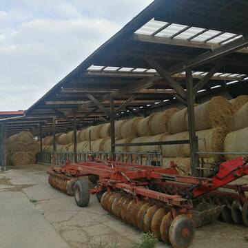
Heu HD-Ballen 2. Schnitt extensiv Heugräser
Drochtersen
M-Kluth
@M-Kluth
Heu
Empfänger lädt ab
Kleinballen/HD-Ballen
Regenfrei
3 weitere...
B+

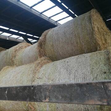
Heu und Stroh in sehr guter Qualität
Nettetal
Agrarhandel J. Weyers e.K.
@Bergwiesenheu
Futter
Empfänger lädt ab
Rundballen
Wird verladen
1 weitere...
B+
Deprecated: Creation of dynamic property Zend_View_Helper_Ads::$adLink is deprecated in /var/www/stall-frei/htdocs/staging.stall-frei.de/library/Psf/View/Helper/Ads.php on line 108

Das Beste für die Hufe
Mechtersen
STALL-FREIde Marketing
@STALL-FREI-Marketing
Hufschmiede und Hufpfleger in Ihrer Nähe

Heu Kleinballen 1. Schnitt - höchste Qualität
Weissach im Tal
Micha
@Micha3
Heu
Empfänger lädt ab
Kleinballen/HD-Ballen
Bio
Regenfrei
2 weitere...
aktuell
B+
Heu 1.Schnitt 2021
Upahl
hermannmeyerzuborgsen
@hermannmeyerzuborgsen
Heu
Empfänger lädt ab
Rundballen
Regenfrei
3 weitere...
P+

Heu 2. Schnitt 2025 Grummet HD Ballen
Altmannstein
Thomas Resch
@Cappo
Heu
Empfänger lädt ab
Kleinballen/HD-Ballen
Wird verladen
2 weitere...
B+

Pferdepension Hit Aktivstall Kürmerhof
Hohenkammer
Kuermerhof
@Kuermerhof
*******JETZT NEU MIT ENTSTAUBTEM BIOHEU*********
*******Demnächst mit einem Abenteuerspielplatz für Pferde ( Extrem Trail/Pa

Biete Heu in Rundballen
Steinheim am Albuch
Westernreiterhof Ziegler
@NadinZiegler
Heu
Rundballen
Bio
Regenfrei
Wird verladen
1 weitere...
B+

Heu in Rundballen (ca.130cm) super Qualität
Pronstorf
Caros Pferdeparadies
@KaOb
Heu
Rundballen
Regenfrei
Wird verladen
2 weitere...
B+


Strohpellet, Strohgranulat, Heu & Stroh
Allmannshofen
J&M Kratzer
@JMKratzer
Einstreu
Lieferant entlädt
Pellets
Wird verladen
2 weitere...
P+

Hafer aus Ernte 2025 auch gequetscht zu verkaufen
Wolfschlugen
Reitanlage im Höfelweg
@Reitanlage-im-Hoefelweg
Futter
Wird verladen
Abholung
B+
Deprecated: Creation of dynamic property Zend_View::$pageCount is deprecated in /var/www/stall-frei/htdocs/staging.stall-frei.de/library/vendor/shardj/zf1-future/library/Zend/View/Abstract.php on line 308
Deprecated: Creation of dynamic property Zend_View::$itemCountPerPage is deprecated in /var/www/stall-frei/htdocs/staging.stall-frei.de/library/vendor/shardj/zf1-future/library/Zend/View/Abstract.php on line 308
Deprecated: Creation of dynamic property Zend_View::$first is deprecated in /var/www/stall-frei/htdocs/staging.stall-frei.de/library/vendor/shardj/zf1-future/library/Zend/View/Abstract.php on line 308
Deprecated: Creation of dynamic property Zend_View::$current is deprecated in /var/www/stall-frei/htdocs/staging.stall-frei.de/library/vendor/shardj/zf1-future/library/Zend/View/Abstract.php on line 308
Deprecated: Creation of dynamic property Zend_View::$last is deprecated in /var/www/stall-frei/htdocs/staging.stall-frei.de/library/vendor/shardj/zf1-future/library/Zend/View/Abstract.php on line 308
Deprecated: Creation of dynamic property Zend_View::$previous is deprecated in /var/www/stall-frei/htdocs/staging.stall-frei.de/library/vendor/shardj/zf1-future/library/Zend/View/Abstract.php on line 308
Deprecated: Creation of dynamic property Zend_View::$next is deprecated in /var/www/stall-frei/htdocs/staging.stall-frei.de/library/vendor/shardj/zf1-future/library/Zend/View/Abstract.php on line 308
Deprecated: Creation of dynamic property Zend_View::$pagesInRange is deprecated in /var/www/stall-frei/htdocs/staging.stall-frei.de/library/vendor/shardj/zf1-future/library/Zend/View/Abstract.php on line 308
Deprecated: Creation of dynamic property Zend_View::$firstPageInRange is deprecated in /var/www/stall-frei/htdocs/staging.stall-frei.de/library/vendor/shardj/zf1-future/library/Zend/View/Abstract.php on line 308
Deprecated: Creation of dynamic property Zend_View::$lastPageInRange is deprecated in /var/www/stall-frei/htdocs/staging.stall-frei.de/library/vendor/shardj/zf1-future/library/Zend/View/Abstract.php on line 308
Deprecated: Creation of dynamic property Zend_View::$currentItemCount is deprecated in /var/www/stall-frei/htdocs/staging.stall-frei.de/library/vendor/shardj/zf1-future/library/Zend/View/Abstract.php on line 308
Deprecated: Creation of dynamic property Zend_View::$totalItemCount is deprecated in /var/www/stall-frei/htdocs/staging.stall-frei.de/library/vendor/shardj/zf1-future/library/Zend/View/Abstract.php on line 308
Deprecated: Creation of dynamic property Zend_View::$firstItemNumber is deprecated in /var/www/stall-frei/htdocs/staging.stall-frei.de/library/vendor/shardj/zf1-future/library/Zend/View/Abstract.php on line 308
Deprecated: Creation of dynamic property Zend_View::$lastItemNumber is deprecated in /var/www/stall-frei/htdocs/staging.stall-frei.de/library/vendor/shardj/zf1-future/library/Zend/View/Abstract.php on line 308
Deprecated: Creation of dynamic property Zend_View::$router is deprecated in /var/www/stall-frei/htdocs/staging.stall-frei.de/library/vendor/shardj/zf1-future/library/Zend/View/Abstract.php on line 308
Deprecated: Creation of dynamic property Zend_View::$urlParams is deprecated in /var/www/stall-frei/htdocs/staging.stall-frei.de/library/vendor/shardj/zf1-future/library/Zend/View/Abstract.php on line 308
Deprecated: Creation of dynamic property Zend_View::$showAds is deprecated in /var/www/stall-frei/htdocs/staging.stall-frei.de/library/vendor/shardj/zf1-future/library/Zend/View/Abstract.php on line 308
Deprecated: Creation of dynamic property Zend_View::$objectIds is deprecated in /var/www/stall-frei/htdocs/staging.stall-frei.de/library/vendor/shardj/zf1-future/library/Zend/View/Abstract.php on line 308
Deprecated: Creation of dynamic property Zend_View::$showNavbar is deprecated in /var/www/stall-frei/htdocs/staging.stall-frei.de/library/vendor/shardj/zf1-future/library/Zend/View/Abstract.php on line 308
Deprecated: Creation of dynamic property Zend_View::$showBreadcrumb is deprecated in /var/www/stall-frei/htdocs/staging.stall-frei.de/library/vendor/shardj/zf1-future/library/Zend/View/Abstract.php on line 308
Deprecated: Creation of dynamic property Zend_View::$showFooter is deprecated in /var/www/stall-frei/htdocs/staging.stall-frei.de/library/vendor/shardj/zf1-future/library/Zend/View/Abstract.php on line 308
Deprecated: Creation of dynamic property Zend_View::$showInternalAds is deprecated in /var/www/stall-frei/htdocs/staging.stall-frei.de/library/vendor/shardj/zf1-future/library/Zend/View/Abstract.php on line 308
Deprecated: Creation of dynamic property Zend_View::$blNoContent is deprecated in /var/www/stall-frei/htdocs/staging.stall-frei.de/library/vendor/shardj/zf1-future/library/Zend/View/Abstract.php on line 308
Deprecated: Creation of dynamic property Zend_View::$sMetaDesc is deprecated in /var/www/stall-frei/htdocs/staging.stall-frei.de/library/vendor/shardj/zf1-future/library/Zend/View/Abstract.php on line 308
Deprecated: Creation of dynamic property Zend_View::$useGmaps is deprecated in /var/www/stall-frei/htdocs/staging.stall-frei.de/library/vendor/shardj/zf1-future/library/Zend/View/Abstract.php on line 308
Deprecated: Creation of dynamic property Zend_View::$touches is deprecated in /var/www/stall-frei/htdocs/staging.stall-frei.de/library/vendor/shardj/zf1-future/library/Zend/View/Abstract.php on line 308
Deprecated: Creation of dynamic property Zend_View::$oProject is deprecated in /var/www/stall-frei/htdocs/staging.stall-frei.de/library/vendor/shardj/zf1-future/library/Zend/View/Abstract.php on line 308
Deprecated: Creation of dynamic property Zend_View::$pageHeadline is deprecated in /var/www/stall-frei/htdocs/staging.stall-frei.de/library/vendor/shardj/zf1-future/library/Zend/View/Abstract.php on line 308
Deprecated: Creation of dynamic property Zend_View::$disableLocationField is deprecated in /var/www/stall-frei/htdocs/staging.stall-frei.de/library/vendor/shardj/zf1-future/library/Zend/View/Abstract.php on line 308
Deprecated: Creation of dynamic property Zend_View::$isSearch is deprecated in /var/www/stall-frei/htdocs/staging.stall-frei.de/library/vendor/shardj/zf1-future/library/Zend/View/Abstract.php on line 308
Deprecated: Creation of dynamic property Zend_View::$pageTitle is deprecated in /var/www/stall-frei/htdocs/staging.stall-frei.de/library/vendor/shardj/zf1-future/library/Zend/View/Abstract.php on line 308
Deprecated: Creation of dynamic property Psf_Form_Element_Text::$class is deprecated in /var/www/stall-frei/htdocs/staging.stall-frei.de/library/vendor/shardj/zf1-future/library/Zend/Form/Element.php on line 874
Deprecated: Creation of dynamic property Psf_Form_Element_Text::$size is deprecated in /var/www/stall-frei/htdocs/staging.stall-frei.de/library/vendor/shardj/zf1-future/library/Zend/Form/Element.php on line 874
Deprecated: Creation of dynamic property Psf_Form_Element_Text::$placeholder is deprecated in /var/www/stall-frei/htdocs/staging.stall-frei.de/library/vendor/shardj/zf1-future/library/Zend/Form/Element.php on line 874
Deprecated: Creation of dynamic property Psf_Form_Element_Hidden::$class is deprecated in /var/www/stall-frei/htdocs/staging.stall-frei.de/library/vendor/shardj/zf1-future/library/Zend/Form/Element.php on line 874
Deprecated: Creation of dynamic property Psf_Form_Element_Hidden::$class is deprecated in /var/www/stall-frei/htdocs/staging.stall-frei.de/library/vendor/shardj/zf1-future/library/Zend/Form/Element.php on line 874
Deprecated: Creation of dynamic property Psf_Form_Element_Hidden::$class is deprecated in /var/www/stall-frei/htdocs/staging.stall-frei.de/library/vendor/shardj/zf1-future/library/Zend/Form/Element.php on line 874
Deprecated: Creation of dynamic property Psf_Form_Element_Hidden::$class is deprecated in /var/www/stall-frei/htdocs/staging.stall-frei.de/library/vendor/shardj/zf1-future/library/Zend/Form/Element.php on line 874
Deprecated: Creation of dynamic property Psf_Form_Element_Select::$class is deprecated in /var/www/stall-frei/htdocs/staging.stall-frei.de/library/vendor/shardj/zf1-future/library/Zend/Form/Element.php on line 874
Deprecated: Creation of dynamic property Psf_Form_Element_Select::$class is deprecated in /var/www/stall-frei/htdocs/staging.stall-frei.de/library/vendor/shardj/zf1-future/library/Zend/Form/Element.php on line 874
Deprecated: Creation of dynamic property Psf_Form_Element_Select::$class is deprecated in /var/www/stall-frei/htdocs/staging.stall-frei.de/library/vendor/shardj/zf1-future/library/Zend/Form/Element.php on line 874
Deprecated: Creation of dynamic property Psf_Form_Element_Select::$class is deprecated in /var/www/stall-frei/htdocs/staging.stall-frei.de/library/vendor/shardj/zf1-future/library/Zend/Form/Element.php on line 874
Deprecated: Creation of dynamic property Zend_View::$sort is deprecated in /var/www/stall-frei/htdocs/staging.stall-frei.de/library/vendor/shardj/zf1-future/library/Zend/View/Abstract.php on line 308
Deprecated: Creation of dynamic property Zend_View::$searchLocation is deprecated in /var/www/stall-frei/htdocs/staging.stall-frei.de/library/vendor/shardj/zf1-future/library/Zend/View/Abstract.php on line 308
Deprecated: Creation of dynamic property Zend_View::$locationHint is deprecated in /var/www/stall-frei/htdocs/staging.stall-frei.de/library/vendor/shardj/zf1-future/library/Zend/View/Abstract.php on line 308
Psf_GeoCoder_Abstract::getLocation: Lütter Get Location CachedOrLive
Psf_GeoCoder_Abstract::getCachedOrLive: Lütter
Psf_GeoCoder_Abstract::convertLocationResult
{"documentation":"https:\/\/opencagedata.com\/api","licenses":[{"name":"see attribution guide","url":"https:\/\/opencagedata.com\/credits"}],"results":[{"bounds":{"northeast":{"lat":51.3463487,"lng":10.1309886},"southwest":{"lat":51.3087164,"lng":10.0748537}},"components":{"ISO_3166-1_alpha-2":"DE","ISO_3166-1_alpha-3":"DEU","ISO_3166-2":["DE-TH"],"_category":"place","_normalized_city":"Uder","_type":"municipality","continent":"Europe","country":"Deutschland","country_code":"de","county":"Landkreis Eichsfeld","municipality":"Uder","political_union":"European Union","state":"Th\u00fcringen","state_code":"TH"},"confidence":7,"formatted":"Uder, Th\u00fcringen, Deutschland","geometry":{"lat":51.3328752,"lng":10.113998}},{"bounds":{"northeast":{"lat":50.4886663,"lng":9.7903898},"southwest":{"lat":50.4609894,"lng":9.7469162}},"components":{"ISO_3166-1_alpha-2":"DE","ISO_3166-1_alpha-3":"DEU","ISO_3166-2":["DE-HE"],"_category":"place","_normalized_city":"L\u00fctter","_type":"village","continent":"Europe","country":"Deutschland","country_code":"de","county":"Landkreis Fulda","municipality":"Eichenzell","political_union":"European Union","state":"Hessen","state_code":"HE","village":"L\u00fctter"},"confidence":7,"formatted":"L\u00fctter, Hessen, Deutschland","geometry":{"lat":50.4774942,"lng":9.757521}},{"bounds":{"northeast":{"lat":50.4946397,"lng":9.929604},"southwest":{"lat":50.4732025,"lng":9.7505479}},"components":{"ISO_3166-1_alpha-2":"DE","ISO_3166-1_alpha-3":"DEU","ISO_3166-2":["DE-HE"],"_category":"natural\/water","_normalized_city":"Weyhers","_type":"river","continent":"Europe","country":"Deutschland","country_code":"de","county":"Landkreis Fulda","municipality":"Ebersburg","political_union":"European Union","postcode":"36157","river":"L\u00fctter","state":"Hessen","state_code":"HE","village":"Weyhers"},"confidence":7,"formatted":"L\u00fctter, 36157 Weyhers, Deutschland","geometry":{"lat":50.4897299,"lng":9.8361892}},{"bounds":{"northeast":{"lat":50.4873668,"lng":9.9281413},"southwest":{"lat":50.4864829,"lng":9.9267574}},"components":{"ISO_3166-1_alpha-2":"DE","ISO_3166-1_alpha-3":"DEU","ISO_3166-2":["DE-HE"],"_category":"natural\/water","_normalized_city":"Poppenhausen (Wasserkuppe)","_type":"stream","continent":"Europe","country":"Deutschland","country_code":"de","county":"Landkreis Fulda","hamlet":"Rodholz","municipality":"Poppenhausen (Wasserkuppe)","political_union":"European Union","postcode":"36163","state":"Hessen","state_code":"HE","stream":"L\u00fctter"},"confidence":9,"formatted":"L\u00fctter, Rodholz, 36163 Poppenhausen (Wasserkuppe), Deutschland","geometry":{"lat":50.4869423,"lng":9.9274505}},{"bounds":{"northeast":{"lat":52.8010405,"lng":10.3973848},"southwest":{"lat":52.6463568,"lng":10.2877809}},"components":{"ISO_3166-1_alpha-2":"DE","ISO_3166-1_alpha-3":"DEU","ISO_3166-2":["DE-NI"],"_category":"natural\/water","_normalized_city":"Eschede","_type":"river","city":"Eschede","continent":"Europe","country":"Deutschland","country_code":"de","county":"Landkreis Celle","municipality":"Samtgemeinde Lachendorf","political_union":"European Union","river":"Lutter","state":"Niedersachsen","state_code":"NI"},"confidence":6,"formatted":"Lutter, Eschede, Niedersachsen, Deutschland","geometry":{"lat":52.7263015,"lng":10.3341075}},{"bounds":{"northeast":{"lat":51.9996444,"lng":8.4973916},"southwest":{"lat":51.9363032,"lng":8.2086281}},"components":{"ISO_3166-1_alpha-2":"DE","ISO_3166-1_alpha-3":"DEU","ISO_3166-2":["DE-NW"],"_category":"natural\/water","_type":"river","continent":"Europe","country":"Deutschland","country_code":"de","county":"Kreis G\u00fctersloh","political_union":"European Union","river":"Lutter","state":"Nordrhein-Westfalen","state_code":"NW"},"confidence":6,"formatted":"Lutter, G\u00fctersloh, Nordrhein-Westfalen, Deutschland","geometry":{"lat":51.9404796,"lng":8.3623615}},{"bounds":{"northeast":{"lat":52.6298596,"lng":9.5345129},"southwest":{"lat":52.5992184,"lng":9.4827321}},"components":{"ISO_3166-1_alpha-2":"DE","ISO_3166-1_alpha-3":"DEU","ISO_3166-2":["DE-NI"],"_category":"place","_normalized_city":"Neustadt am R\u00fcbenberge","_type":"city","continent":"Europe","country":"Deutschland","country_code":"de","county":"Region Hannover","political_union":"European Union","state":"Niedersachsen","state_code":"NI","town":"Neustadt am R\u00fcbenberge"},"confidence":7,"formatted":"Neustadt am R\u00fcbenberge, Niedersachsen, Deutschland","geometry":{"lat":52.6139794,"lng":9.5093277}},{"bounds":{"northeast":{"lat":52.0639602,"lng":8.6160608},"southwest":{"lat":51.9989604,"lng":8.4964749}},"components":{"ISO_3166-1_alpha-2":"DE","ISO_3166-1_alpha-3":"DEU","ISO_3166-2":["DE-NW"],"_category":"natural\/water","_normalized_city":"Bielefeld","_type":"stream","city":"Bielefeld","continent":"Europe","country":"Deutschland","country_code":"de","political_union":"European Union","state":"Nordrhein-Westfalen","state_code":"NW","stream":"Lutter"},"confidence":7,"formatted":"Lutter, Bielefeld, Nordrhein-Westfalen, Deutschland","geometry":{"lat":52.0226866,"lng":8.5655021}},{"bounds":{"northeast":{"lat":51.6421201,"lng":10.461162},"southwest":{"lat":51.6228249,"lng":10.4584323}},"components":{"ISO_3166-1_alpha-2":"DE","ISO_3166-1_alpha-3":"DEU","ISO_3166-2":["DE-NI"],"_category":"natural\/water","_normalized_city":"Bad Lauterberg im Harz","_type":"stream","continent":"Europe","country":"Deutschland","country_code":"de","county":"Landkreis G\u00f6ttingen","hamlet":"Kupferh\u00fctte","political_union":"European Union","postcode":"37431","state":"Niedersachsen","state_code":"NI","stream":"Lutter","town":"Bad Lauterberg im Harz"},"confidence":8,"formatted":"Lutter, Kupferh\u00fctte, 37431 Bad Lauterberg im Harz, Deutschland","geometry":{"lat":51.6317806,"lng":10.4593216}},{"components":{"ISO_3166-1_alpha-2":"FR","ISO_3166-1_alpha-3":"FRA","ISO_3166-2":["FR-GES","FR-6AE","FR-68"],"_category":"road","_normalized_city":"Raedersdorf","_type":"road","city":"Raedersdorf","continent":"Europe","country":"France","country_code":"fr","county":"Haut-Rhin","local_authority":"Communaut\u00e9 de communes Sundgau","political_union":"European Union","postcode":"68480","road":"Rue de Lutter","state":"Grand Est","state_code":"GES"},"confidence":3,"formatted":"Rue de Lutter, 68480 Raedersdorf, France","geometry":{"lat":47.473399,"lng":7.367919}}],"status":{"code":200,"message":"OK"},"stay_informed":{"blog":"https:\/\/blog.opencagedata.com","mastodon":"https:\/\/en.osm.town\/@opencage"},"thanks":"For using an OpenCage API","timestamp":{"created_http":"Sun, 08 Feb 2026 15:15:25 GMT","created_unix":1770563725},"total_results":10}Array
(
[0] => stdClass Object
(
[bounds] => stdClass Object
(
[northeast] => stdClass Object
(
[lat] => 51.3463487
[lng] => 10.1309886
)
[southwest] => stdClass Object
(
[lat] => 51.3087164
[lng] => 10.0748537
)
)
[components] => stdClass Object
(
[ISO_3166-1_alpha-2] => DE
[ISO_3166-1_alpha-3] => DEU
[ISO_3166-2] => Array
(
[0] => DE-TH
)
[_category] => place
[_normalized_city] => Uder
[_type] => municipality
[continent] => Europe
[country] => Deutschland
[country_code] => de
[county] => Landkreis Eichsfeld
[municipality] => Uder
[political_union] => European Union
[state] => Thüringen
[state_code] => TH
)
[confidence] => 7
[formatted] => Uder, Thüringen, Deutschland
[geometry] => stdClass Object
(
[lat] => 51.3328752
[lng] => 10.113998
)
)
[1] => stdClass Object
(
[bounds] => stdClass Object
(
[northeast] => stdClass Object
(
[lat] => 50.4886663
[lng] => 9.7903898
)
[southwest] => stdClass Object
(
[lat] => 50.4609894
[lng] => 9.7469162
)
)
[components] => stdClass Object
(
[ISO_3166-1_alpha-2] => DE
[ISO_3166-1_alpha-3] => DEU
[ISO_3166-2] => Array
(
[0] => DE-HE
)
[_category] => place
[_normalized_city] => Lütter
[_type] => village
[continent] => Europe
[country] => Deutschland
[country_code] => de
[county] => Landkreis Fulda
[municipality] => Eichenzell
[political_union] => European Union
[state] => Hessen
[state_code] => HE
[village] => Lütter
)
[confidence] => 7
[formatted] => Lütter, Hessen, Deutschland
[geometry] => stdClass Object
(
[lat] => 50.4774942
[lng] => 9.757521
)
)
[2] => stdClass Object
(
[bounds] => stdClass Object
(
[northeast] => stdClass Object
(
[lat] => 50.4946397
[lng] => 9.929604
)
[southwest] => stdClass Object
(
[lat] => 50.4732025
[lng] => 9.7505479
)
)
[components] => stdClass Object
(
[ISO_3166-1_alpha-2] => DE
[ISO_3166-1_alpha-3] => DEU
[ISO_3166-2] => Array
(
[0] => DE-HE
)
[_category] => natural/water
[_normalized_city] => Weyhers
[_type] => river
[continent] => Europe
[country] => Deutschland
[country_code] => de
[county] => Landkreis Fulda
[municipality] => Ebersburg
[political_union] => European Union
[postcode] => 36157
[river] => Lütter
[state] => Hessen
[state_code] => HE
[village] => Weyhers
)
[confidence] => 7
[formatted] => Lütter, 36157 Weyhers, Deutschland
[geometry] => stdClass Object
(
[lat] => 50.4897299
[lng] => 9.8361892
)
)
[3] => stdClass Object
(
[bounds] => stdClass Object
(
[northeast] => stdClass Object
(
[lat] => 50.4873668
[lng] => 9.9281413
)
[southwest] => stdClass Object
(
[lat] => 50.4864829
[lng] => 9.9267574
)
)
[components] => stdClass Object
(
[ISO_3166-1_alpha-2] => DE
[ISO_3166-1_alpha-3] => DEU
[ISO_3166-2] => Array
(
[0] => DE-HE
)
[_category] => natural/water
[_normalized_city] => Poppenhausen (Wasserkuppe)
[_type] => stream
[continent] => Europe
[country] => Deutschland
[country_code] => de
[county] => Landkreis Fulda
[hamlet] => Rodholz
[municipality] => Poppenhausen (Wasserkuppe)
[political_union] => European Union
[postcode] => 36163
[state] => Hessen
[state_code] => HE
[stream] => Lütter
)
[confidence] => 9
[formatted] => Lütter, Rodholz, 36163 Poppenhausen (Wasserkuppe), Deutschland
[geometry] => stdClass Object
(
[lat] => 50.4869423
[lng] => 9.9274505
)
)
[4] => stdClass Object
(
[bounds] => stdClass Object
(
[northeast] => stdClass Object
(
[lat] => 52.8010405
[lng] => 10.3973848
)
[southwest] => stdClass Object
(
[lat] => 52.6463568
[lng] => 10.2877809
)
)
[components] => stdClass Object
(
[ISO_3166-1_alpha-2] => DE
[ISO_3166-1_alpha-3] => DEU
[ISO_3166-2] => Array
(
[0] => DE-NI
)
[_category] => natural/water
[_normalized_city] => Eschede
[_type] => river
[city] => Eschede
[continent] => Europe
[country] => Deutschland
[country_code] => de
[county] => Landkreis Celle
[municipality] => Samtgemeinde Lachendorf
[political_union] => European Union
[river] => Lutter
[state] => Niedersachsen
[state_code] => NI
)
[confidence] => 6
[formatted] => Lutter, Eschede, Niedersachsen, Deutschland
[geometry] => stdClass Object
(
[lat] => 52.7263015
[lng] => 10.3341075
)
)
[5] => stdClass Object
(
[bounds] => stdClass Object
(
[northeast] => stdClass Object
(
[lat] => 51.9996444
[lng] => 8.4973916
)
[southwest] => stdClass Object
(
[lat] => 51.9363032
[lng] => 8.2086281
)
)
[components] => stdClass Object
(
[ISO_3166-1_alpha-2] => DE
[ISO_3166-1_alpha-3] => DEU
[ISO_3166-2] => Array
(
[0] => DE-NW
)
[_category] => natural/water
[_type] => river
[continent] => Europe
[country] => Deutschland
[country_code] => de
[county] => Kreis Gütersloh
[political_union] => European Union
[river] => Lutter
[state] => Nordrhein-Westfalen
[state_code] => NW
)
[confidence] => 6
[formatted] => Lutter, Gütersloh, Nordrhein-Westfalen, Deutschland
[geometry] => stdClass Object
(
[lat] => 51.9404796
[lng] => 8.3623615
)
)
[6] => stdClass Object
(
[bounds] => stdClass Object
(
[northeast] => stdClass Object
(
[lat] => 52.6298596
[lng] => 9.5345129
)
[southwest] => stdClass Object
(
[lat] => 52.5992184
[lng] => 9.4827321
)
)
[components] => stdClass Object
(
[ISO_3166-1_alpha-2] => DE
[ISO_3166-1_alpha-3] => DEU
[ISO_3166-2] => Array
(
[0] => DE-NI
)
[_category] => place
[_normalized_city] => Neustadt am Rübenberge
[_type] => city
[continent] => Europe
[country] => Deutschland
[country_code] => de
[county] => Region Hannover
[political_union] => European Union
[state] => Niedersachsen
[state_code] => NI
[town] => Neustadt am Rübenberge
)
[confidence] => 7
[formatted] => Neustadt am Rübenberge, Niedersachsen, Deutschland
[geometry] => stdClass Object
(
[lat] => 52.6139794
[lng] => 9.5093277
)
)
[7] => stdClass Object
(
[bounds] => stdClass Object
(
[northeast] => stdClass Object
(
[lat] => 52.0639602
[lng] => 8.6160608
)
[southwest] => stdClass Object
(
[lat] => 51.9989604
[lng] => 8.4964749
)
)
[components] => stdClass Object
(
[ISO_3166-1_alpha-2] => DE
[ISO_3166-1_alpha-3] => DEU
[ISO_3166-2] => Array
(
[0] => DE-NW
)
[_category] => natural/water
[_normalized_city] => Bielefeld
[_type] => stream
[city] => Bielefeld
[continent] => Europe
[country] => Deutschland
[country_code] => de
[political_union] => European Union
[state] => Nordrhein-Westfalen
[state_code] => NW
[stream] => Lutter
)
[confidence] => 7
[formatted] => Lutter, Bielefeld, Nordrhein-Westfalen, Deutschland
[geometry] => stdClass Object
(
[lat] => 52.0226866
[lng] => 8.5655021
)
)
[8] => stdClass Object
(
[bounds] => stdClass Object
(
[northeast] => stdClass Object
(
[lat] => 51.6421201
[lng] => 10.461162
)
[southwest] => stdClass Object
(
[lat] => 51.6228249
[lng] => 10.4584323
)
)
[components] => stdClass Object
(
[ISO_3166-1_alpha-2] => DE
[ISO_3166-1_alpha-3] => DEU
[ISO_3166-2] => Array
(
[0] => DE-NI
)
[_category] => natural/water
[_normalized_city] => Bad Lauterberg im Harz
[_type] => stream
[continent] => Europe
[country] => Deutschland
[country_code] => de
[county] => Landkreis Göttingen
[hamlet] => Kupferhütte
[political_union] => European Union
[postcode] => 37431
[state] => Niedersachsen
[state_code] => NI
[stream] => Lutter
[town] => Bad Lauterberg im Harz
)
[confidence] => 8
[formatted] => Lutter, Kupferhütte, 37431 Bad Lauterberg im Harz, Deutschland
[geometry] => stdClass Object
(
[lat] => 51.6317806
[lng] => 10.4593216
)
)
[9] => stdClass Object
(
[components] => stdClass Object
(
[ISO_3166-1_alpha-2] => FR
[ISO_3166-1_alpha-3] => FRA
[ISO_3166-2] => Array
(
[0] => FR-GES
[1] => FR-6AE
[2] => FR-68
)
[_category] => road
[_normalized_city] => Raedersdorf
[_type] => road
[city] => Raedersdorf
[continent] => Europe
[country] => France
[country_code] => fr
[county] => Haut-Rhin
[local_authority] => Communauté de communes Sundgau
[political_union] => European Union
[postcode] => 68480
[road] => Rue de Lutter
[state] => Grand Est
[state_code] => GES
)
[confidence] => 3
[formatted] => Rue de Lutter, 68480 Raedersdorf, France
[geometry] => stdClass Object
(
[lat] => 47.473399
[lng] => 7.367919
)
)
)
Psf_GeoCoder_OpenCageData::getKeyMap: 0
stdClass Object
(
    [bounds] => stdClass Object
        (
            [northeast] => stdClass Object
                (
                    [lat] => 51.3463487
                    [lng] => 10.1309886
                )

            [southwest] => stdClass Object
                (
                    [lat] => 51.3087164
                    [lng] => 10.0748537
                )

        )

    [components] => stdClass Object
        (
            [ISO_3166-1_alpha-2] => DE
            [ISO_3166-1_alpha-3] => DEU
            [ISO_3166-2] => Array
                (
                    [0] => DE-TH
                )

            [_category] => place
            [_normalized_city] => Uder
            [_type] => municipality
            [continent] => Europe
            [country] => Deutschland
            [country_code] => de
            [county] => Landkreis Eichsfeld
            [municipality] => Uder
            [political_union] => European Union
            [state] => Thüringen
            [state_code] => TH
        )

    [confidence] => 7
    [formatted] => Uder, Thüringen, Deutschland
    [geometry] => stdClass Object
        (
            [lat] => 51.3328752
            [lng] => 10.113998
        )

)
Psf_GeoCoder_OpenCageData::getCounty: Eichsfeld
Psf_GeoCoder_OpenCageData::addMissingData REFETCH!
Array
(
    [address] => Uder, Thüringen, Deutschland
    [type] => municipality
    [street] =>
    [city] =>
    [county] => Eichsfeld
    [state] => Thüringen
    [zip] =>
    [country] => Deutschland
    [suburb] =>
    [countrycode] => de
    [latitude] => 51.3328752
    [longitude] => 10.113998
    [accuracy] => 1
    [confidence] => 7
    [bounds] => stdClass Object
        (
            [northeast] => stdClass Object
                (
                    [lat] => 51.3463487
                    [lng] => 10.1309886
                )

            [southwest] => stdClass Object
                (
                    [lat] => 51.3087164
                    [lng] => 10.0748537
                )

        )

)
reformat!
Array
(
    [address] => Uder, Thüringen, Deutschland
    [type] => municipality
    [street] =>
    [city] =>
    [county] => Eichsfeld
    [state] => Thüringen
    [zip] =>
    [country] => Deutschland
    [suburb] =>
    [countrycode] => de
    [latitude] => 51.3328752
    [longitude] => 10.113998
    [accuracy] => 1
    [confidence] => 7
    [bounds] => stdClass Object
        (
            [northeast] => stdClass Object
                (
                    [lat] => 51.3463487
                    [lng] => 10.1309886
                )

            [southwest] => stdClass Object
                (
                    [lat] => 51.3087164
                    [lng] => 10.0748537
                )

        )

    [place] => , Thüringen
    [hash] => be411ba72f63ba851c285b19a0ee33b0
)
Psf_GeoCoder_OpenCageData::getKeyMap: 1
stdClass Object
(
    [bounds] => stdClass Object
        (
            [northeast] => stdClass Object
                (
                    [lat] => 50.4886663
                    [lng] => 9.7903898
                )

            [southwest] => stdClass Object
                (
                    [lat] => 50.4609894
                    [lng] => 9.7469162
                )

        )

    [components] => stdClass Object
        (
            [ISO_3166-1_alpha-2] => DE
            [ISO_3166-1_alpha-3] => DEU
            [ISO_3166-2] => Array
                (
                    [0] => DE-HE
                )

            [_category] => place
            [_normalized_city] => Lütter
            [_type] => village
            [continent] => Europe
            [country] => Deutschland
            [country_code] => de
            [county] => Landkreis Fulda
            [municipality] => Eichenzell
            [political_union] => European Union
            [state] => Hessen
            [state_code] => HE
            [village] => Lütter
        )

    [confidence] => 7
    [formatted] => Lütter, Hessen, Deutschland
    [geometry] => stdClass Object
        (
            [lat] => 50.4774942
            [lng] => 9.757521
        )

)
Psf_GeoCoder_OpenCageData::getCounty: Fulda
Psf_GeoCoder_OpenCageData::addMissingData REFETCH!
Array
(
    [address] => Lütter, Hessen, Deutschland
    [type] => village
    [street] =>
    [city] => Lütter
    [county] => Fulda
    [state] => Hessen
    [zip] =>
    [country] => Deutschland
    [suburb] =>
    [countrycode] => de
    [latitude] => 50.4774942
    [longitude] => 9.757521
    [accuracy] => 1
    [confidence] => 7
    [bounds] => stdClass Object
        (
            [northeast] => stdClass Object
                (
                    [lat] => 50.4886663
                    [lng] => 9.7903898
                )

            [southwest] => stdClass Object
                (
                    [lat] => 50.4609894
                    [lng] => 9.7469162
                )

        )

)
reformat!
Array
(
    [address] => Lütter, Hessen, Deutschland
    [type] => village
    [street] =>
    [city] => Lütter
    [county] => Fulda
    [state] => Hessen
    [zip] =>
    [country] => Deutschland
    [suburb] =>
    [countrycode] => de
    [latitude] => 50.4774942
    [longitude] => 9.757521
    [accuracy] => 1
    [confidence] => 7
    [bounds] => stdClass Object
        (
            [northeast] => stdClass Object
                (
                    [lat] => 50.4886663
                    [lng] => 9.7903898
                )

            [southwest] => stdClass Object
                (
                    [lat] => 50.4609894
                    [lng] => 9.7469162
                )

        )

    [place] => Lütter, Hessen
    [hash] => ca171c27c10597af84df3e4e6099cbe0
)
Psf_GeoCoder_OpenCageData::getKeyMap: 2
stdClass Object
(
    [bounds] => stdClass Object
        (
            [northeast] => stdClass Object
                (
                    [lat] => 50.4946397
                    [lng] => 9.929604
                )

            [southwest] => stdClass Object
                (
                    [lat] => 50.4732025
                    [lng] => 9.7505479
                )

        )

    [components] => stdClass Object
        (
            [ISO_3166-1_alpha-2] => DE
            [ISO_3166-1_alpha-3] => DEU
            [ISO_3166-2] => Array
                (
                    [0] => DE-HE
                )

            [_category] => natural/water
            [_normalized_city] => Weyhers
            [_type] => river
            [continent] => Europe
            [country] => Deutschland
            [country_code] => de
            [county] => Landkreis Fulda
            [municipality] => Ebersburg
            [political_union] => European Union
            [postcode] => 36157
            [river] => Lütter
            [state] => Hessen
            [state_code] => HE
            [village] => Weyhers
        )

    [confidence] => 7
    [formatted] => Lütter, 36157 Weyhers, Deutschland
    [geometry] => stdClass Object
        (
            [lat] => 50.4897299
            [lng] => 9.8361892
        )

)
Psf_GeoCoder_OpenCageData::getCounty: Fulda
Psf_GeoCoder_OpenCageData::addMissingData REFETCH!
Array
(
    [address] => Lütter, 36157 Weyhers, Deutschland
    [type] => river
    [street] =>
    [city] => Weyhers
    [county] => Fulda
    [state] => Hessen
    [zip] => 36157
    [country] => Deutschland
    [suburb] =>
    [countrycode] => de
    [latitude] => 50.4897299
    [longitude] => 9.8361892
    [accuracy] => 1
    [confidence] => 7
    [bounds] => stdClass Object
        (
            [northeast] => stdClass Object
                (
                    [lat] => 50.4946397
                    [lng] => 9.929604
                )

            [southwest] => stdClass Object
                (
                    [lat] => 50.4732025
                    [lng] => 9.7505479
                )

        )

)
reformat!
Array
(
    [address] => Lütter, 36157 Weyhers, Deutschland
    [type] => river
    [street] =>
    [city] => Weyhers
    [county] => Fulda
    [state] => Hessen
    [zip] => 36157
    [country] => Deutschland
    [suburb] =>
    [countrycode] => de
    [latitude] => 50.4897299
    [longitude] => 9.8361892
    [accuracy] => 1
    [confidence] => 7
    [bounds] => stdClass Object
        (
            [northeast] => stdClass Object
                (
                    [lat] => 50.4946397
                    [lng] => 9.929604
                )

            [southwest] => stdClass Object
                (
                    [lat] => 50.4732025
                    [lng] => 9.7505479
                )

        )

    [place] => 36157 Weyhers, Hessen
    [hash] => 9d5e851b7d061e07ba800456d7a53a7b
)
Psf_GeoCoder_OpenCageData::getKeyMap: 3
stdClass Object
(
    [bounds] => stdClass Object
        (
            [northeast] => stdClass Object
                (
                    [lat] => 50.4873668
                    [lng] => 9.9281413
                )

            [southwest] => stdClass Object
                (
                    [lat] => 50.4864829
                    [lng] => 9.9267574
                )

        )

    [components] => stdClass Object
        (
            [ISO_3166-1_alpha-2] => DE
            [ISO_3166-1_alpha-3] => DEU
            [ISO_3166-2] => Array
                (
                    [0] => DE-HE
                )

            [_category] => natural/water
            [_normalized_city] => Poppenhausen (Wasserkuppe)
            [_type] => stream
            [continent] => Europe
            [country] => Deutschland
            [country_code] => de
            [county] => Landkreis Fulda
            [hamlet] => Rodholz
            [municipality] => Poppenhausen (Wasserkuppe)
            [political_union] => European Union
            [postcode] => 36163
            [state] => Hessen
            [state_code] => HE
            [stream] => Lütter
        )

    [confidence] => 9
    [formatted] => Lütter, Rodholz, 36163 Poppenhausen (Wasserkuppe), Deutschland
    [geometry] => stdClass Object
        (
            [lat] => 50.4869423
            [lng] => 9.9274505
        )

)
Psf_GeoCoder_OpenCageData::getCounty: Fulda
Psf_GeoCoder_OpenCageData::addMissingData REFETCH!
Array
(
    [address] => Lütter, Rodholz, 36163 Poppenhausen (Wasserkuppe), Deutschland
    [type] => stream
    [street] => Rodholz
    [city] =>
    [county] => Fulda
    [state] => Hessen
    [zip] => 36163
    [country] => Deutschland
    [suburb] =>
    [countrycode] => de
    [latitude] => 50.4869423
    [longitude] => 9.9274505
    [accuracy] => 1
    [confidence] => 9
    [bounds] => stdClass Object
        (
            [northeast] => stdClass Object
                (
                    [lat] => 50.4873668
                    [lng] => 9.9281413
                )

            [southwest] => stdClass Object
                (
                    [lat] => 50.4864829
                    [lng] => 9.9267574
                )

        )

)
reformat!
Array
(
    [address] => Lütter, Rodholz, 36163 Poppenhausen (Wasserkuppe), Deutschland
    [type] => stream
    [street] => Rodholz
    [city] =>
    [county] => Fulda
    [state] => Hessen
    [zip] => 36163
    [country] => Deutschland
    [suburb] =>
    [countrycode] => de
    [latitude] => 50.4869423
    [longitude] => 9.9274505
    [accuracy] => 1
    [confidence] => 9
    [bounds] => stdClass Object
        (
            [northeast] => stdClass Object
                (
                    [lat] => 50.4873668
                    [lng] => 9.9281413
                )

            [southwest] => stdClass Object
                (
                    [lat] => 50.4864829
                    [lng] => 9.9267574
                )

        )

    [place] => Rodholz, 36163 , Hessen
    [hash] => e62adbfe6fec7305f189e0c3c2602f90
)
Psf_GeoCoder_OpenCageData::getKeyMap: 4
stdClass Object
(
    [bounds] => stdClass Object
        (
            [northeast] => stdClass Object
                (
                    [lat] => 52.8010405
                    [lng] => 10.3973848
                )

            [southwest] => stdClass Object
                (
                    [lat] => 52.6463568
                    [lng] => 10.2877809
                )

        )

    [components] => stdClass Object
        (
            [ISO_3166-1_alpha-2] => DE
            [ISO_3166-1_alpha-3] => DEU
            [ISO_3166-2] => Array
                (
                    [0] => DE-NI
                )

            [_category] => natural/water
            [_normalized_city] => Eschede
            [_type] => river
            [city] => Eschede
            [continent] => Europe
            [country] => Deutschland
            [country_code] => de
            [county] => Landkreis Celle
            [municipality] => Samtgemeinde Lachendorf
            [political_union] => European Union
            [river] => Lutter
            [state] => Niedersachsen
            [state_code] => NI
        )

    [confidence] => 6
    [formatted] => Lutter, Eschede, Niedersachsen, Deutschland
    [geometry] => stdClass Object
        (
            [lat] => 52.7263015
            [lng] => 10.3341075
        )

)
Psf_GeoCoder_OpenCageData::getCounty: Celle
Psf_GeoCoder_OpenCageData::addMissingData REFETCH!
Array
(
    [address] => Lutter, Eschede, Niedersachsen, Deutschland
    [type] => river
    [street] =>
    [city] => Eschede
    [county] => Celle
    [state] => Niedersachsen
    [zip] =>
    [country] => Deutschland
    [suburb] =>
    [countrycode] => de
    [latitude] => 52.7263015
    [longitude] => 10.3341075
    [accuracy] => 1
    [confidence] => 6
    [bounds] => stdClass Object
        (
            [northeast] => stdClass Object
                (
                    [lat] => 52.8010405
                    [lng] => 10.3973848
                )

            [southwest] => stdClass Object
                (
                    [lat] => 52.6463568
                    [lng] => 10.2877809
                )

        )

)
reformat!
Array
(
    [address] => Lutter, Eschede, Niedersachsen, Deutschland
    [type] => river
    [street] =>
    [city] => Eschede
    [county] => Celle
    [state] => Niedersachsen
    [zip] =>
    [country] => Deutschland
    [suburb] =>
    [countrycode] => de
    [latitude] => 52.7263015
    [longitude] => 10.3341075
    [accuracy] => 1
    [confidence] => 6
    [bounds] => stdClass Object
        (
            [northeast] => stdClass Object
                (
                    [lat] => 52.8010405
                    [lng] => 10.3973848
                )

            [southwest] => stdClass Object
                (
                    [lat] => 52.6463568
                    [lng] => 10.2877809
                )

        )

    [place] => Eschede, Niedersachsen
    [hash] => db39164a256335dd0d2f7f7b42868287
)
Psf_GeoCoder_OpenCageData::getKeyMap: 5
stdClass Object
(
    [bounds] => stdClass Object
        (
            [northeast] => stdClass Object
                (
                    [lat] => 51.9996444
                    [lng] => 8.4973916
                )

            [southwest] => stdClass Object
                (
                    [lat] => 51.9363032
                    [lng] => 8.2086281
                )

        )

    [components] => stdClass Object
        (
            [ISO_3166-1_alpha-2] => DE
            [ISO_3166-1_alpha-3] => DEU
            [ISO_3166-2] => Array
                (
                    [0] => DE-NW
                )

            [_category] => natural/water
            [_type] => river
            [continent] => Europe
            [country] => Deutschland
            [country_code] => de
            [county] => Kreis Gütersloh
            [political_union] => European Union
            [river] => Lutter
            [state] => Nordrhein-Westfalen
            [state_code] => NW
        )

    [confidence] => 6
    [formatted] => Lutter, Gütersloh, Nordrhein-Westfalen, Deutschland
    [geometry] => stdClass Object
        (
            [lat] => 51.9404796
            [lng] => 8.3623615
        )

)
Psf_GeoCoder_OpenCageData::getCounty: Gütersloh
Psf_GeoCoder_OpenCageData::addMissingData REFETCH!
Array
(
    [address] => Lutter, Gütersloh, Nordrhein-Westfalen, Deutschland
    [type] => river
    [street] =>
    [city] =>
    [county] => Gütersloh
    [state] => Nordrhein-Westfalen
    [zip] =>
    [country] => Deutschland
    [suburb] =>
    [countrycode] => de
    [latitude] => 51.9404796
    [longitude] => 8.3623615
    [accuracy] => 1
    [confidence] => 6
    [bounds] => stdClass Object
        (
            [northeast] => stdClass Object
                (
                    [lat] => 51.9996444
                    [lng] => 8.4973916
                )

            [southwest] => stdClass Object
                (
                    [lat] => 51.9363032
                    [lng] => 8.2086281
                )

        )

)
reformat!
Array
(
    [address] => Lutter, Gütersloh, Nordrhein-Westfalen, Deutschland
    [type] => river
    [street] =>
    [city] =>
    [county] => Gütersloh
    [state] => Nordrhein-Westfalen
    [zip] =>
    [country] => Deutschland
    [suburb] =>
    [countrycode] => de
    [latitude] => 51.9404796
    [longitude] => 8.3623615
    [accuracy] => 1
    [confidence] => 6
    [bounds] => stdClass Object
        (
            [northeast] => stdClass Object
                (
                    [lat] => 51.9996444
                    [lng] => 8.4973916
                )

            [southwest] => stdClass Object
                (
                    [lat] => 51.9363032
                    [lng] => 8.2086281
                )

        )

    [place] => , Nordrhein-Westfalen
    [hash] => 644b8c15c8948e95434516b8ef8d7312
)
Psf_GeoCoder_OpenCageData::getKeyMap: 6
stdClass Object
(
    [bounds] => stdClass Object
        (
            [northeast] => stdClass Object
                (
                    [lat] => 52.6298596
                    [lng] => 9.5345129
                )

            [southwest] => stdClass Object
                (
                    [lat] => 52.5992184
                    [lng] => 9.4827321
                )

        )

    [components] => stdClass Object
        (
            [ISO_3166-1_alpha-2] => DE
            [ISO_3166-1_alpha-3] => DEU
            [ISO_3166-2] => Array
                (
                    [0] => DE-NI
                )

            [_category] => place
            [_normalized_city] => Neustadt am Rübenberge
            [_type] => city
            [continent] => Europe
            [country] => Deutschland
            [country_code] => de
            [county] => Region Hannover
            [political_union] => European Union
            [state] => Niedersachsen
            [state_code] => NI
            [town] => Neustadt am Rübenberge
        )

    [confidence] => 7
    [formatted] => Neustadt am Rübenberge, Niedersachsen, Deutschland
    [geometry] => stdClass Object
        (
            [lat] => 52.6139794
            [lng] => 9.5093277
        )

)
Psf_GeoCoder_OpenCageData::getCounty: Hannover
Psf_GeoCoder_OpenCageData::addMissingData REFETCH!
Array
(
    [address] => Neustadt am Rübenberge, Niedersachsen, Deutschland
    [type] => city
    [street] =>
    [city] => Neustadt am Rübenberge
    [county] => Hannover
    [state] => Niedersachsen
    [zip] =>
    [country] => Deutschland
    [suburb] =>
    [countrycode] => de
    [latitude] => 52.6139794
    [longitude] => 9.5093277
    [accuracy] => 1
    [confidence] => 7
    [bounds] => stdClass Object
        (
            [northeast] => stdClass Object
                (
                    [lat] => 52.6298596
                    [lng] => 9.5345129
                )

            [southwest] => stdClass Object
                (
                    [lat] => 52.5992184
                    [lng] => 9.4827321
                )

        )

)
reformat!
Array
(
    [address] => Neustadt am Rübenberge, Niedersachsen, Deutschland
    [type] => city
    [street] =>
    [city] => Neustadt am Rübenberge
    [county] => Hannover
    [state] => Niedersachsen
    [zip] =>
    [country] => Deutschland
    [suburb] =>
    [countrycode] => de
    [latitude] => 52.6139794
    [longitude] => 9.5093277
    [accuracy] => 1
    [confidence] => 7
    [bounds] => stdClass Object
        (
            [northeast] => stdClass Object
                (
                    [lat] => 52.6298596
                    [lng] => 9.5345129
                )

            [southwest] => stdClass Object
                (
                    [lat] => 52.5992184
                    [lng] => 9.4827321
                )

        )

    [place] => Neustadt am Rübenberge, Niedersachsen
    [hash] => 69c47e57af38d3c33668f844fc9fd8e4
)
Psf_GeoCoder_OpenCageData::getKeyMap: 7
stdClass Object
(
    [bounds] => stdClass Object
        (
            [northeast] => stdClass Object
                (
                    [lat] => 52.0639602
                    [lng] => 8.6160608
                )

            [southwest] => stdClass Object
                (
                    [lat] => 51.9989604
                    [lng] => 8.4964749
                )

        )

    [components] => stdClass Object
        (
            [ISO_3166-1_alpha-2] => DE
            [ISO_3166-1_alpha-3] => DEU
            [ISO_3166-2] => Array
                (
                    [0] => DE-NW
                )

            [_category] => natural/water
            [_normalized_city] => Bielefeld
            [_type] => stream
            [city] => Bielefeld
            [continent] => Europe
            [country] => Deutschland
            [country_code] => de
            [political_union] => European Union
            [state] => Nordrhein-Westfalen
            [state_code] => NW
            [stream] => Lutter
        )

    [confidence] => 7
    [formatted] => Lutter, Bielefeld, Nordrhein-Westfalen, Deutschland
    [geometry] => stdClass Object
        (
            [lat] => 52.0226866
            [lng] => 8.5655021
        )

)
Psf_GeoCoder_OpenCageData::getCounty: Bielefeld
Psf_GeoCoder_OpenCageData::addMissingData REFETCH!
Array
(
    [address] => Lutter, Bielefeld, Nordrhein-Westfalen, Deutschland
    [type] => stream
    [street] =>
    [city] => Bielefeld
    [county] => Bielefeld
    [state] => Nordrhein-Westfalen
    [zip] =>
    [country] => Deutschland
    [suburb] =>
    [countrycode] => de
    [latitude] => 52.0226866
    [longitude] => 8.5655021
    [accuracy] => 1
    [confidence] => 7
    [bounds] => stdClass Object
        (
            [northeast] => stdClass Object
                (
                    [lat] => 52.0639602
                    [lng] => 8.6160608
                )

            [southwest] => stdClass Object
                (
                    [lat] => 51.9989604
                    [lng] => 8.4964749
                )

        )

)
reformat!
Array
(
    [address] => Lutter, Bielefeld, Nordrhein-Westfalen, Deutschland
    [type] => stream
    [street] =>
    [city] => Bielefeld
    [county] => Bielefeld
    [state] => Nordrhein-Westfalen
    [zip] =>
    [country] => Deutschland
    [suburb] =>
    [countrycode] => de
    [latitude] => 52.0226866
    [longitude] => 8.5655021
    [accuracy] => 1
    [confidence] => 7
    [bounds] => stdClass Object
        (
            [northeast] => stdClass Object
                (
                    [lat] => 52.0639602
                    [lng] => 8.6160608
                )

            [southwest] => stdClass Object
                (
                    [lat] => 51.9989604
                    [lng] => 8.4964749
                )

        )

    [place] => Bielefeld, Nordrhein-Westfalen
    [hash] => 77a45c5fcc76209af87c37ebc07b948b
)
Psf_GeoCoder_OpenCageData::getKeyMap: 8
stdClass Object
(
    [bounds] => stdClass Object
        (
            [northeast] => stdClass Object
                (
                    [lat] => 51.6421201
                    [lng] => 10.461162
                )

            [southwest] => stdClass Object
                (
                    [lat] => 51.6228249
                    [lng] => 10.4584323
                )

        )

    [components] => stdClass Object
        (
            [ISO_3166-1_alpha-2] => DE
            [ISO_3166-1_alpha-3] => DEU
            [ISO_3166-2] => Array
                (
                    [0] => DE-NI
                )

            [_category] => natural/water
            [_normalized_city] => Bad Lauterberg im Harz
            [_type] => stream
            [continent] => Europe
            [country] => Deutschland
            [country_code] => de
            [county] => Landkreis Göttingen
            [hamlet] => Kupferhütte
            [political_union] => European Union
            [postcode] => 37431
            [state] => Niedersachsen
            [state_code] => NI
            [stream] => Lutter
            [town] => Bad Lauterberg im Harz
        )

    [confidence] => 8
    [formatted] => Lutter, Kupferhütte, 37431 Bad Lauterberg im Harz, Deutschland
    [geometry] => stdClass Object
        (
            [lat] => 51.6317806
            [lng] => 10.4593216
        )

)
Psf_GeoCoder_OpenCageData::getCounty: Göttingen
Psf_GeoCoder_OpenCageData::addMissingData REFETCH!
Array
(
    [address] => Lutter, Kupferhütte, 37431 Bad Lauterberg im Harz, Deutschland
    [type] => stream
    [street] => Kupferhütte
    [city] => Bad Lauterberg im Harz
    [county] => Göttingen
    [state] => Niedersachsen
    [zip] => 37431
    [country] => Deutschland
    [suburb] =>
    [countrycode] => de
    [latitude] => 51.6317806
    [longitude] => 10.4593216
    [accuracy] => 1
    [confidence] => 8
    [bounds] => stdClass Object
        (
            [northeast] => stdClass Object
                (
                    [lat] => 51.6421201
                    [lng] => 10.461162
                )

            [southwest] => stdClass Object
                (
                    [lat] => 51.6228249
                    [lng] => 10.4584323
                )

        )

)
reformat!
Array
(
    [address] => Lutter, Kupferhütte, 37431 Bad Lauterberg im Harz, Deutschland
    [type] => stream
    [street] => Kupferhütte
    [city] => Bad Lauterberg im Harz
    [county] => Göttingen
    [state] => Niedersachsen
    [zip] => 37431
    [country] => Deutschland
    [suburb] =>
    [countrycode] => de
    [latitude] => 51.6317806
    [longitude] => 10.4593216
    [accuracy] => 1
    [confidence] => 8
    [bounds] => stdClass Object
        (
            [northeast] => stdClass Object
                (
                    [lat] => 51.6421201
                    [lng] => 10.461162
                )

            [southwest] => stdClass Object
                (
                    [lat] => 51.6228249
                    [lng] => 10.4584323
                )

        )

    [place] => Kupferhütte, 37431 Bad Lauterberg im Harz, Niedersachsen
    [hash] => 15a2242fc6570716dd122f8c760a43b8
)
Psf_GeoCoder_OpenCageData::getKeyMap: 9
stdClass Object
(
    [components] => stdClass Object
        (
            [ISO_3166-1_alpha-2] => FR
            [ISO_3166-1_alpha-3] => FRA
            [ISO_3166-2] => Array
                (
                    [0] => FR-GES
                    [1] => FR-6AE
                    [2] => FR-68
                )

            [_category] => road
            [_normalized_city] => Raedersdorf
            [_type] => road
            [city] => Raedersdorf
            [continent] => Europe
            [country] => France
            [country_code] => fr
            [county] => Haut-Rhin
            [local_authority] => Communauté de communes Sundgau
            [political_union] => European Union
            [postcode] => 68480
            [road] => Rue de Lutter
            [state] => Grand Est
            [state_code] => GES
        )

    [confidence] => 3
    [formatted] => Rue de Lutter, 68480 Raedersdorf, France
    [geometry] => stdClass Object
        (
            [lat] => 47.473399
            [lng] => 7.367919
        )

)
Psf_GeoCoder_OpenCageData::getCounty: Haut-Rhin
Psf_GeoCoder_OpenCageData::addMissingData REFETCH!
Array
(
    [address] => Rue de Lutter, 68480 Raedersdorf, France
    [type] => road
    [street] => Rue de Lutter
    [city] => Raedersdorf
    [county] => Haut-Rhin
    [state] => Grand Est
    [zip] => 68480
    [country] => France
    [suburb] =>
    [countrycode] => fr
    [latitude] => 47.473399
    [longitude] => 7.367919
    [accuracy] => 1
    [confidence] => 3
    [bounds] =>
)
reformat!
Array
(
    [address] => Rue de Lutter, 68480 Raedersdorf, France
    [type] => road
    [street] => Rue de Lutter
    [city] => Raedersdorf
    [county] => Haut-Rhin
    [state] => Grand Est
    [zip] => 68480
    [country] => France
    [suburb] =>
    [countrycode] => fr
    [latitude] => 47.473399
    [longitude] => 7.367919
    [accuracy] => 1
    [confidence] => 3
    [bounds] =>
    [place] => Rue de Lutter, 68480 Raedersdorf, Grand Est
    [hash] => d6ab81941abdcd66bfdd60fc6a4f9015
)
Deprecated: Creation of dynamic property Zend_View::$locationHintStyle is deprecated in /var/www/stall-frei/htdocs/staging.stall-frei.de/library/vendor/shardj/zf1-future/library/Zend/View/Abstract.php on line 308
Deprecated: Creation of dynamic property Zend_View::$adGeoLocation is deprecated in /var/www/stall-frei/htdocs/staging.stall-frei.de/library/vendor/shardj/zf1-future/library/Zend/View/Abstract.php on line 308
Deprecated: Creation of dynamic property Zend_View::$recordCount is deprecated in /var/www/stall-frei/htdocs/staging.stall-frei.de/library/vendor/shardj/zf1-future/library/Zend/View/Abstract.php on line 308
Deprecated: Creation of dynamic property Zend_View::$paginationParams is deprecated in /var/www/stall-frei/htdocs/staging.stall-frei.de/library/vendor/shardj/zf1-future/library/Zend/View/Abstract.php on line 308
Deprecated: Creation of dynamic property Zend_View::$objectPaginator is deprecated in /var/www/stall-frei/htdocs/staging.stall-frei.de/library/vendor/shardj/zf1-future/library/Zend/View/Abstract.php on line 308
Deprecated: Creation of dynamic property Zend_View::$featuredObjects is deprecated in /var/www/stall-frei/htdocs/staging.stall-frei.de/library/vendor/shardj/zf1-future/library/Zend/View/Abstract.php on line 308
Deprecated: Creation of dynamic property Zend_View::$hints is deprecated in /var/www/stall-frei/htdocs/staging.stall-frei.de/library/vendor/shardj/zf1-future/library/Zend/View/Abstract.php on line 308
Deprecated: Creation of dynamic property Zend_View::$attributeHints is deprecated in /var/www/stall-frei/htdocs/staging.stall-frei.de/library/vendor/shardj/zf1-future/library/Zend/View/Abstract.php on line 308
Deprecated: Creation of dynamic property Zend_View::$oSearchForm is deprecated in /var/www/stall-frei/htdocs/staging.stall-frei.de/library/vendor/shardj/zf1-future/library/Zend/View/Abstract.php on line 308