Deprecated: Creation of dynamic property Zend_View::$sMode is deprecated in /var/www/stall-frei/htdocs/staging.stall-frei.de/library/vendor/shardj/zf1-future/library/Zend/View/Abstract.php on line 308
Heu, Stroh oder Futter in Hütting
Gesucht wird in "91809 Hütting, Deutschland"
92 Einträge
Deprecated: Creation of dynamic property Zend_View::$listObjects is deprecated in /var/www/stall-frei/htdocs/staging.stall-frei.de/library/vendor/shardj/zf1-future/library/Zend/View/Abstract.php on line 308
Deprecated: Creation of dynamic property Zend_View::$listMode is deprecated in /var/www/stall-frei/htdocs/staging.stall-frei.de/library/vendor/shardj/zf1-future/library/Zend/View/Abstract.php on line 308
Deprecated: Creation of dynamic property Zend_View::$renderedObjects is deprecated in /var/www/stall-frei/htdocs/staging.stall-frei.de/library/vendor/shardj/zf1-future/library/Zend/View/Abstract.php on line 308
Deprecated: Creation of dynamic property Zend_View::$index is deprecated in /var/www/stall-frei/htdocs/staging.stall-frei.de/library/vendor/shardj/zf1-future/library/Zend/View/Abstract.php on line 308
Deprecated: Creation of dynamic property Zend_View::$displayMode is deprecated in /var/www/stall-frei/htdocs/staging.stall-frei.de/library/vendor/shardj/zf1-future/library/Zend/View/Abstract.php on line 308
Deprecated: Creation of dynamic property Zend_View::$remarketingIds is deprecated in /var/www/stall-frei/htdocs/staging.stall-frei.de/library/vendor/shardj/zf1-future/library/Zend/View/Abstract.php on line 308
Deprecated: Creation of dynamic property Zend_View::$listItem is deprecated in /var/www/stall-frei/htdocs/staging.stall-frei.de/library/vendor/shardj/zf1-future/library/Zend/View/Abstract.php on line 308
Deprecated: Creation of dynamic property Zend_View::$object is deprecated in /var/www/stall-frei/htdocs/staging.stall-frei.de/library/vendor/shardj/zf1-future/library/Zend/View/Abstract.php on line 308
Deprecated: Creation of dynamic property Zend_View::$attributes is deprecated in /var/www/stall-frei/htdocs/staging.stall-frei.de/library/vendor/shardj/zf1-future/library/Zend/View/Abstract.php on line 308


Strohpellet, Strohgranulat, Heu & Stroh
Allmannshofen
J&M Kratzer
@JMKratzer
Einstreu
Lieferant entlädt
Pellets
Wird verladen
2 weitere...
P+

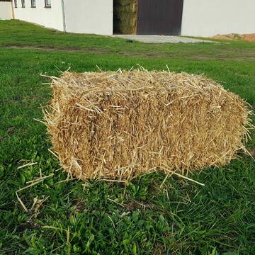
Heu 2. Schnitt 2025 Grummet HD Ballen
Altmannstein
Thomas Resch
@Cappo
Heu
Empfänger lädt ab
Kleinballen/HD-Ballen
Wird verladen
2 weitere...
B+
Deprecated: Creation of dynamic property Zend_View_Helper_Ads::$adLink is deprecated in /var/www/stall-frei/htdocs/staging.stall-frei.de/library/Psf/View/Helper/Ads.php on line 108

Pferdepension Hit Aktivstall Kürmerhof
Hohenkammer
Kuermerhof
@Kuermerhof
*******JETZT NEU MIT ENTSTAUBTEM BIOHEU*********
*******Demnächst mit einem Abenteuerspielplatz für Pferde ( Extrem Trail/Pa

HD-Heuballen, 1. Schnitt & 2. Schnitt
Hilpoltstein
KnollmeyerBallen
@KnollmeyerBallen
Heu
Lieferant entlädt
Kleinballen/HD-Ballen
Regenfrei
3 weitere...
B+
HD-Strohballen, Gersten-, Dinkel- und Weizenstroh
Hilpoltstein
KnollmeyerBallen
@KnollmeyerBallen
Einstreu
Lieferant entlädt
Kleinballen/HD-Ballen
Regenfrei
3 weitere...
B+
Leider kein Vorschaubild
Leider kein Vorschaubild
heu 2025 heu 2ter schnitt 2025
Maisach
Reitstall Thurner
@ReitstallThurner
Heu
Empfänger lädt ab
Rundballen
Regenfrei
3 weitere...
B+

Biete Heu in Rundballen
Steinheim am Albuch
Westernreiterhof Ziegler
@NadinZiegler
Heu
Rundballen
Bio
Regenfrei
Wird verladen
1 weitere...
B+

Futtersack HeuToy, Fressbremse in pink
Mechtersen
STALL-FREIde Marketing
@STALL-FREI-Marketing
Stundenlange Beschäftigung die
Koliken vorbeugt, geringe Staubinhalation mit
steuerbarer Futterentnahme
Leider kein Vorschaubild
Leider kein Vorschaubild
Heucobs zu verkaufen
Langenau
Bewegungsstall-Unseld
@Bewegungsstall-Unseld
Heu
Großballen
Regenfrei
Wird verladen
B+
Leider kein Vorschaubild
Leider kein Vorschaubild
Heucobs in Bigbags oder 25 kg Säcke
Langenau
Bewegungsstall-Unseld
@Bewegungsstall-Unseld
Futter
Pellets
Regenfrei
Wird verladen
1 weitere...
B+

Bedampftes Heu in Großballen für Allergikerpferd...
Langenau
Bewegungsstall-Unseld
@Bewegungsstall-Unseld
Heu
Großballen
Regenfrei
Wird verladen
1 weitere...
B+

B+
Deprecated: Creation of dynamic property Zend_View::$pageCount is deprecated in /var/www/stall-frei/htdocs/staging.stall-frei.de/library/vendor/shardj/zf1-future/library/Zend/View/Abstract.php on line 308
Deprecated: Creation of dynamic property Zend_View::$itemCountPerPage is deprecated in /var/www/stall-frei/htdocs/staging.stall-frei.de/library/vendor/shardj/zf1-future/library/Zend/View/Abstract.php on line 308
Deprecated: Creation of dynamic property Zend_View::$first is deprecated in /var/www/stall-frei/htdocs/staging.stall-frei.de/library/vendor/shardj/zf1-future/library/Zend/View/Abstract.php on line 308
Deprecated: Creation of dynamic property Zend_View::$current is deprecated in /var/www/stall-frei/htdocs/staging.stall-frei.de/library/vendor/shardj/zf1-future/library/Zend/View/Abstract.php on line 308
Deprecated: Creation of dynamic property Zend_View::$last is deprecated in /var/www/stall-frei/htdocs/staging.stall-frei.de/library/vendor/shardj/zf1-future/library/Zend/View/Abstract.php on line 308
Deprecated: Creation of dynamic property Zend_View::$next is deprecated in /var/www/stall-frei/htdocs/staging.stall-frei.de/library/vendor/shardj/zf1-future/library/Zend/View/Abstract.php on line 308
Deprecated: Creation of dynamic property Zend_View::$pagesInRange is deprecated in /var/www/stall-frei/htdocs/staging.stall-frei.de/library/vendor/shardj/zf1-future/library/Zend/View/Abstract.php on line 308
Deprecated: Creation of dynamic property Zend_View::$firstPageInRange is deprecated in /var/www/stall-frei/htdocs/staging.stall-frei.de/library/vendor/shardj/zf1-future/library/Zend/View/Abstract.php on line 308
Deprecated: Creation of dynamic property Zend_View::$lastPageInRange is deprecated in /var/www/stall-frei/htdocs/staging.stall-frei.de/library/vendor/shardj/zf1-future/library/Zend/View/Abstract.php on line 308
Deprecated: Creation of dynamic property Zend_View::$currentItemCount is deprecated in /var/www/stall-frei/htdocs/staging.stall-frei.de/library/vendor/shardj/zf1-future/library/Zend/View/Abstract.php on line 308
Deprecated: Creation of dynamic property Zend_View::$totalItemCount is deprecated in /var/www/stall-frei/htdocs/staging.stall-frei.de/library/vendor/shardj/zf1-future/library/Zend/View/Abstract.php on line 308
Deprecated: Creation of dynamic property Zend_View::$firstItemNumber is deprecated in /var/www/stall-frei/htdocs/staging.stall-frei.de/library/vendor/shardj/zf1-future/library/Zend/View/Abstract.php on line 308
Deprecated: Creation of dynamic property Zend_View::$lastItemNumber is deprecated in /var/www/stall-frei/htdocs/staging.stall-frei.de/library/vendor/shardj/zf1-future/library/Zend/View/Abstract.php on line 308
Deprecated: Creation of dynamic property Zend_View::$router is deprecated in /var/www/stall-frei/htdocs/staging.stall-frei.de/library/vendor/shardj/zf1-future/library/Zend/View/Abstract.php on line 308
Deprecated: Creation of dynamic property Zend_View::$urlParams is deprecated in /var/www/stall-frei/htdocs/staging.stall-frei.de/library/vendor/shardj/zf1-future/library/Zend/View/Abstract.php on line 308
Deprecated: Creation of dynamic property Zend_View::$showAds is deprecated in /var/www/stall-frei/htdocs/staging.stall-frei.de/library/vendor/shardj/zf1-future/library/Zend/View/Abstract.php on line 308
Deprecated: Creation of dynamic property Zend_View::$objectIds is deprecated in /var/www/stall-frei/htdocs/staging.stall-frei.de/library/vendor/shardj/zf1-future/library/Zend/View/Abstract.php on line 308
Deprecated: Creation of dynamic property Zend_View::$showNavbar is deprecated in /var/www/stall-frei/htdocs/staging.stall-frei.de/library/vendor/shardj/zf1-future/library/Zend/View/Abstract.php on line 308
Deprecated: Creation of dynamic property Zend_View::$showBreadcrumb is deprecated in /var/www/stall-frei/htdocs/staging.stall-frei.de/library/vendor/shardj/zf1-future/library/Zend/View/Abstract.php on line 308
Deprecated: Creation of dynamic property Zend_View::$showFooter is deprecated in /var/www/stall-frei/htdocs/staging.stall-frei.de/library/vendor/shardj/zf1-future/library/Zend/View/Abstract.php on line 308
Deprecated: Creation of dynamic property Zend_View::$showInternalAds is deprecated in /var/www/stall-frei/htdocs/staging.stall-frei.de/library/vendor/shardj/zf1-future/library/Zend/View/Abstract.php on line 308
Deprecated: Creation of dynamic property Zend_View::$blNoContent is deprecated in /var/www/stall-frei/htdocs/staging.stall-frei.de/library/vendor/shardj/zf1-future/library/Zend/View/Abstract.php on line 308
Deprecated: Creation of dynamic property Zend_View::$sMetaDesc is deprecated in /var/www/stall-frei/htdocs/staging.stall-frei.de/library/vendor/shardj/zf1-future/library/Zend/View/Abstract.php on line 308
Deprecated: Creation of dynamic property Zend_View::$useGmaps is deprecated in /var/www/stall-frei/htdocs/staging.stall-frei.de/library/vendor/shardj/zf1-future/library/Zend/View/Abstract.php on line 308
Deprecated: Creation of dynamic property Zend_View::$touches is deprecated in /var/www/stall-frei/htdocs/staging.stall-frei.de/library/vendor/shardj/zf1-future/library/Zend/View/Abstract.php on line 308
Deprecated: Creation of dynamic property Zend_View::$oProject is deprecated in /var/www/stall-frei/htdocs/staging.stall-frei.de/library/vendor/shardj/zf1-future/library/Zend/View/Abstract.php on line 308
Deprecated: Creation of dynamic property Zend_View::$pageHeadline is deprecated in /var/www/stall-frei/htdocs/staging.stall-frei.de/library/vendor/shardj/zf1-future/library/Zend/View/Abstract.php on line 308
Deprecated: Creation of dynamic property Zend_View::$disableLocationField is deprecated in /var/www/stall-frei/htdocs/staging.stall-frei.de/library/vendor/shardj/zf1-future/library/Zend/View/Abstract.php on line 308
Deprecated: Creation of dynamic property Zend_View::$isSearch is deprecated in /var/www/stall-frei/htdocs/staging.stall-frei.de/library/vendor/shardj/zf1-future/library/Zend/View/Abstract.php on line 308
Deprecated: Creation of dynamic property Zend_View::$pageTitle is deprecated in /var/www/stall-frei/htdocs/staging.stall-frei.de/library/vendor/shardj/zf1-future/library/Zend/View/Abstract.php on line 308
Deprecated: Creation of dynamic property Psf_Form_Element_Text::$class is deprecated in /var/www/stall-frei/htdocs/staging.stall-frei.de/library/vendor/shardj/zf1-future/library/Zend/Form/Element.php on line 874
Deprecated: Creation of dynamic property Psf_Form_Element_Text::$size is deprecated in /var/www/stall-frei/htdocs/staging.stall-frei.de/library/vendor/shardj/zf1-future/library/Zend/Form/Element.php on line 874
Deprecated: Creation of dynamic property Psf_Form_Element_Text::$placeholder is deprecated in /var/www/stall-frei/htdocs/staging.stall-frei.de/library/vendor/shardj/zf1-future/library/Zend/Form/Element.php on line 874
Deprecated: Creation of dynamic property Psf_Form_Element_Hidden::$class is deprecated in /var/www/stall-frei/htdocs/staging.stall-frei.de/library/vendor/shardj/zf1-future/library/Zend/Form/Element.php on line 874
Deprecated: Creation of dynamic property Psf_Form_Element_Hidden::$class is deprecated in /var/www/stall-frei/htdocs/staging.stall-frei.de/library/vendor/shardj/zf1-future/library/Zend/Form/Element.php on line 874
Deprecated: Creation of dynamic property Psf_Form_Element_Hidden::$class is deprecated in /var/www/stall-frei/htdocs/staging.stall-frei.de/library/vendor/shardj/zf1-future/library/Zend/Form/Element.php on line 874
Deprecated: Creation of dynamic property Psf_Form_Element_Hidden::$class is deprecated in /var/www/stall-frei/htdocs/staging.stall-frei.de/library/vendor/shardj/zf1-future/library/Zend/Form/Element.php on line 874
Deprecated: Creation of dynamic property Psf_Form_Element_Select::$class is deprecated in /var/www/stall-frei/htdocs/staging.stall-frei.de/library/vendor/shardj/zf1-future/library/Zend/Form/Element.php on line 874
Deprecated: Creation of dynamic property Psf_Form_Element_Select::$class is deprecated in /var/www/stall-frei/htdocs/staging.stall-frei.de/library/vendor/shardj/zf1-future/library/Zend/Form/Element.php on line 874
Deprecated: Creation of dynamic property Psf_Form_Element_Select::$class is deprecated in /var/www/stall-frei/htdocs/staging.stall-frei.de/library/vendor/shardj/zf1-future/library/Zend/Form/Element.php on line 874
Deprecated: Creation of dynamic property Psf_Form_Element_Select::$class is deprecated in /var/www/stall-frei/htdocs/staging.stall-frei.de/library/vendor/shardj/zf1-future/library/Zend/Form/Element.php on line 874
Deprecated: Creation of dynamic property Zend_View::$sort is deprecated in /var/www/stall-frei/htdocs/staging.stall-frei.de/library/vendor/shardj/zf1-future/library/Zend/View/Abstract.php on line 308
Deprecated: Creation of dynamic property Zend_View::$searchLocation is deprecated in /var/www/stall-frei/htdocs/staging.stall-frei.de/library/vendor/shardj/zf1-future/library/Zend/View/Abstract.php on line 308
Deprecated: Creation of dynamic property Zend_View::$locationHint is deprecated in /var/www/stall-frei/htdocs/staging.stall-frei.de/library/vendor/shardj/zf1-future/library/Zend/View/Abstract.php on line 308
Psf_GeoCoder_Abstract::getLocation: Hütting Get Location CachedOrLive
Psf_GeoCoder_Abstract::getCachedOrLive: Hütting
Psf_GeoCoder_OpenCageData::makeApiRequest: response:
Array
(
[documentation] => https://opencagedata.com/api
[licenses] => Array
(
[0] => Array
(
[name] => see attribution guide
[url] => https://opencagedata.com/credits
)
)
[results] => Array
(
[0] => Array
(
[bounds] => Array
(
[northeast] => Array
(
[lat] => 48.8177697
[lng] => 11.1314482
)
[southwest] => Array
(
[lat] => 48.7777697
[lng] => 11.0914482
)
)
[components] => Array
(
[ISO_3166-1_alpha-2] => DE
[ISO_3166-1_alpha-3] => DEU
[ISO_3166-2] => Array
(
[0] => DE-BY
)
[_category] => place
[_normalized_city] => Rennertshofen
[_type] => village
[city] => Rennertshofen
[continent] => Europe
[country] => Deutschland
[country_code] => de
[county] => Landkreis Neuburg-Schrobenhausen
[political_union] => European Union
[postcode] => 91809
[state] => Bayern
[state_code] => BY
[village] => Hütting
)
[confidence] => 7
[formatted] => 91809 Hütting, Deutschland
[geometry] => Array
(
[lat] => 48.7977697
[lng] => 11.1114482
)
)
[1] => Array
(
[bounds] => Array
(
[northeast] => Array
(
[lat] => 48.4871725
[lng] => 13.3139648
)
[southwest] => Array
(
[lat] => 48.4471725
[lng] => 13.2739648
)
)
[components] => Array
(
[ISO_3166-1_alpha-2] => DE
[ISO_3166-1_alpha-3] => DEU
[ISO_3166-2] => Array
(
[0] => DE-BY
)
[_category] => place
[_normalized_city] => Ruhstorf a.d.Rott
[_type] => village
[city] => Ruhstorf a.d.Rott
[continent] => Europe
[country] => Deutschland
[country_code] => de
[county] => Landkreis Passau
[political_union] => European Union
[postcode] => 94099
[state] => Bayern
[state_code] => BY
[village] => Hütting
)
[confidence] => 7
[formatted] => 94099 Hütting, Deutschland
[geometry] => Array
(
[lat] => 48.4671725
[lng] => 13.2939648
)
)
[2] => Array
(
[bounds] => Array
(
[northeast] => Array
(
[lat] => 48.3082278
[lng] => 12.8104452
)
[southwest] => Array
(
[lat] => 48.2682278
[lng] => 12.7704452
)
)
[components] => Array
(
[ISO_3166-1_alpha-2] => DE
[ISO_3166-1_alpha-3] => DEU
[ISO_3166-2] => Array
(
[0] => DE-BY
)
[_category] => place
[_normalized_city] => Erlbach
[_type] => hamlet
[continent] => Europe
[country] => Deutschland
[country_code] => de
[county] => Landkreis Altötting
[hamlet] => Hütting
[municipality] => Reischach (VGem)
[political_union] => European Union
[postcode] => 84567
[state] => Bayern
[state_code] => BY
[village] => Erlbach
)
[confidence] => 7
[formatted] => Hütting, 84567 Erlbach, Deutschland
[geometry] => Array
(
[lat] => 48.2882278
[lng] => 12.7904452
)
)
[3] => Array
(
[bounds] => Array
(
[northeast] => Array
(
[lat] => 48.7809997
[lng] => 13.1481234
)
[southwest] => Array
(
[lat] => 48.7409997
[lng] => 13.1081234
)
)
[components] => Array
(
[ISO_3166-1_alpha-2] => DE
[ISO_3166-1_alpha-3] => DEU
[ISO_3166-2] => Array
(
[0] => DE-BY
)
[_category] => place
[_normalized_city] => Hengersberg
[_type] => hamlet
[continent] => Europe
[country] => Deutschland
[country_code] => de
[county] => Landkreis Deggendorf
[hamlet] => Hütting
[political_union] => European Union
[postcode] => 94547
[state] => Bayern
[state_code] => BY
[village] => Hengersberg
)
[confidence] => 7
[formatted] => Hütting, 94547 Hengersberg, Deutschland
[geometry] => Array
(
[lat] => 48.7609997
[lng] => 13.1281234
)
)
[4] => Array
(
[bounds] => Array
(
[northeast] => Array
(
[lat] => 48.0999418
[lng] => 12.5751822
)
[southwest] => Array
(
[lat] => 48.0599418
[lng] => 12.5351822
)
)
[components] => Array
(
[ISO_3166-1_alpha-2] => DE
[ISO_3166-1_alpha-3] => DEU
[ISO_3166-2] => Array
(
[0] => DE-BY
)
[_category] => place
[_normalized_city] => Tacherting
[_type] => hamlet
[continent] => Europe
[country] => Deutschland
[country_code] => de
[county] => Landkreis Traunstein
[hamlet] => Hütting
[political_union] => European Union
[postcode] => 83342
[state] => Bayern
[state_code] => BY
[village] => Tacherting
)
[confidence] => 7
[formatted] => Hütting, 83342 Tacherting, Deutschland
[geometry] => Array
(
[lat] => 48.0799418
[lng] => 12.5551822
)
)
[5] => Array
(
[bounds] => Array
(
[northeast] => Array
(
[lat] => 48.1402391
[lng] => 12.6648147
)
[southwest] => Array
(
[lat] => 48.1002391
[lng] => 12.6248147
)
)
[components] => Array
(
[ISO_3166-1_alpha-2] => DE
[ISO_3166-1_alpha-3] => DEU
[ISO_3166-2] => Array
(
[0] => DE-BY
)
[_category] => place
[_normalized_city] => Kirchweidach
[_type] => hamlet
[continent] => Europe
[country] => Deutschland
[country_code] => de
[county] => Landkreis Altötting
[hamlet] => Hütting
[municipality] => Kirchweidach (VGem)
[political_union] => European Union
[postcode] => 84553
[state] => Bayern
[state_code] => BY
[village] => Kirchweidach
)
[confidence] => 7
[formatted] => Hütting, 84553 Kirchweidach, Deutschland
[geometry] => Array
(
[lat] => 48.1202391
[lng] => 12.6448147
)
)
[6] => Array
(
[bounds] => Array
(
[northeast] => Array
(
[lat] => 48.3296074
[lng] => 12.6046823
)
[southwest] => Array
(
[lat] => 48.2896074
[lng] => 12.5646823
)
)
[components] => Array
(
[ISO_3166-1_alpha-2] => DE
[ISO_3166-1_alpha-3] => DEU
[ISO_3166-2] => Array
(
[0] => DE-BY
)
[_category] => place
[_normalized_city] => Pleiskirchen
[_type] => hamlet
[continent] => Europe
[country] => Deutschland
[country_code] => de
[county] => Landkreis Altötting
[hamlet] => Hütting
[political_union] => European Union
[postcode] => 84568
[state] => Bayern
[state_code] => BY
[village] => Pleiskirchen
)
[confidence] => 7
[formatted] => Hütting, 84568 Pleiskirchen, Deutschland
[geometry] => Array
(
[lat] => 48.3096074
[lng] => 12.5846823
)
)
[7] => Array
(
[bounds] => Array
(
[northeast] => Array
(
[lat] => 49.154293
[lng] => 12.5070908
)
[southwest] => Array
(
[lat] => 49.114293
[lng] => 12.4670908
)
)
[components] => Array
(
[ISO_3166-1_alpha-2] => DE
[ISO_3166-1_alpha-3] => DEU
[ISO_3166-2] => Array
(
[0] => DE-BY
)
[_category] => place
[_normalized_city] => Michelsneukirchen
[_type] => hamlet
[city] => Michelsneukirchen
[continent] => Europe
[country] => Deutschland
[country_code] => de
[county] => Landkreis Cham
[hamlet] => Hutting
[municipality] => Falkenstein (VGem)
[political_union] => European Union
[postcode] => 93167
[state] => Bayern
[state_code] => BY
)
[confidence] => 7
[formatted] => Hutting, 93167 Michelsneukirchen, Deutschland
[geometry] => Array
(
[lat] => 49.134293
[lng] => 12.4870908
)
)
[8] => Array
(
[bounds] => Array
(
[northeast] => Array
(
[lat] => 48.3442987
[lng] => 12.9794667
)
[southwest] => Array
(
[lat] => 48.3441987
[lng] => 12.9793667
)
)
[components] => Array
(
[ISO_3166-1_alpha-2] => DE
[ISO_3166-1_alpha-3] => DEU
[ISO_3166-2] => Array
(
[0] => DE-BY
)
[_category] => building
[_normalized_city] => Wittibreut
[_type] => building
[continent] => Europe
[country] => Deutschland
[country_code] => de
[county] => Landkreis Rottal-Inn
[isolated_dwelling] => Hutting
[political_union] => European Union
[postcode] => 84384
[state] => Bayern
[state_code] => BY
[village] => Wittibreut
)
[confidence] => 10
[formatted] => Hutting, 84384 Wittibreut, Deutschland
[geometry] => Array
(
[lat] => 48.3442487
[lng] => 12.9794167
)
)
[9] => Array
(
[components] => Array
(
[ISO_3166-1_alpha-2] => FR
[ISO_3166-1_alpha-3] => FRA
[ISO_3166-2] => Array
(
[0] => FR-GES
[1] => FR-57
)
[_category] => road
[_normalized_city] => Kalhausen
[_type] => road
[city] => Kalhausen
[continent] => Europe
[country] => France
[country_code] => fr
[county] => Moselle
[local_authority] => Communauté d'agglomération Sarreguemines Confluences
[political_union] => European Union
[postcode] => 57412
[road] => Hutting
[state] => Grand Est
[state_code] => GES
)
[confidence] => 3
[formatted] => Hutting, 57412 Kalhausen, France
[geometry] => Array
(
[lat] => 49.020758
[lng] => 7.128137
)
)
)
[status] => Array
(
[code] => 200
[message] => OK
)
[stay_informed] => Array
(
[blog] => https://blog.opencagedata.com
[mastodon] => https://en.osm.town/@opencage
)
[thanks] => For using an OpenCage API
[timestamp] => Array
(
[created_http] => Sun, 08 Feb 2026 08:38:02 GMT
[created_unix] => 1770539882
)
[total_results] => 10
)
Psf_GeoCoder_Abstract::convertLocationResult
{"documentation":"https:\/\/opencagedata.com\/api","licenses":[{"name":"see attribution guide","url":"https:\/\/opencagedata.com\/credits"}],"results":[{"bounds":{"northeast":{"lat":48.8177697,"lng":11.1314482},"southwest":{"lat":48.7777697,"lng":11.0914482}},"components":{"ISO_3166-1_alpha-2":"DE","ISO_3166-1_alpha-3":"DEU","ISO_3166-2":["DE-BY"],"_category":"place","_normalized_city":"Rennertshofen","_type":"village","city":"Rennertshofen","continent":"Europe","country":"Deutschland","country_code":"de","county":"Landkreis Neuburg-Schrobenhausen","political_union":"European Union","postcode":"91809","state":"Bayern","state_code":"BY","village":"H\u00fctting"},"confidence":7,"formatted":"91809 H\u00fctting, Deutschland","geometry":{"lat":48.7977697,"lng":11.1114482}},{"bounds":{"northeast":{"lat":48.4871725,"lng":13.3139648},"southwest":{"lat":48.4471725,"lng":13.2739648}},"components":{"ISO_3166-1_alpha-2":"DE","ISO_3166-1_alpha-3":"DEU","ISO_3166-2":["DE-BY"],"_category":"place","_normalized_city":"Ruhstorf a.d.Rott","_type":"village","city":"Ruhstorf a.d.Rott","continent":"Europe","country":"Deutschland","country_code":"de","county":"Landkreis Passau","political_union":"European Union","postcode":"94099","state":"Bayern","state_code":"BY","village":"H\u00fctting"},"confidence":7,"formatted":"94099 H\u00fctting, Deutschland","geometry":{"lat":48.4671725,"lng":13.2939648}},{"bounds":{"northeast":{"lat":48.3082278,"lng":12.8104452},"southwest":{"lat":48.2682278,"lng":12.7704452}},"components":{"ISO_3166-1_alpha-2":"DE","ISO_3166-1_alpha-3":"DEU","ISO_3166-2":["DE-BY"],"_category":"place","_normalized_city":"Erlbach","_type":"hamlet","continent":"Europe","country":"Deutschland","country_code":"de","county":"Landkreis Alt\u00f6tting","hamlet":"H\u00fctting","municipality":"Reischach (VGem)","political_union":"European Union","postcode":"84567","state":"Bayern","state_code":"BY","village":"Erlbach"},"confidence":7,"formatted":"H\u00fctting, 84567 Erlbach, Deutschland","geometry":{"lat":48.2882278,"lng":12.7904452}},{"bounds":{"northeast":{"lat":48.7809997,"lng":13.1481234},"southwest":{"lat":48.7409997,"lng":13.1081234}},"components":{"ISO_3166-1_alpha-2":"DE","ISO_3166-1_alpha-3":"DEU","ISO_3166-2":["DE-BY"],"_category":"place","_normalized_city":"Hengersberg","_type":"hamlet","continent":"Europe","country":"Deutschland","country_code":"de","county":"Landkreis Deggendorf","hamlet":"H\u00fctting","political_union":"European Union","postcode":"94547","state":"Bayern","state_code":"BY","village":"Hengersberg"},"confidence":7,"formatted":"H\u00fctting, 94547 Hengersberg, Deutschland","geometry":{"lat":48.7609997,"lng":13.1281234}},{"bounds":{"northeast":{"lat":48.0999418,"lng":12.5751822},"southwest":{"lat":48.0599418,"lng":12.5351822}},"components":{"ISO_3166-1_alpha-2":"DE","ISO_3166-1_alpha-3":"DEU","ISO_3166-2":["DE-BY"],"_category":"place","_normalized_city":"Tacherting","_type":"hamlet","continent":"Europe","country":"Deutschland","country_code":"de","county":"Landkreis Traunstein","hamlet":"H\u00fctting","political_union":"European Union","postcode":"83342","state":"Bayern","state_code":"BY","village":"Tacherting"},"confidence":7,"formatted":"H\u00fctting, 83342 Tacherting, Deutschland","geometry":{"lat":48.0799418,"lng":12.5551822}},{"bounds":{"northeast":{"lat":48.1402391,"lng":12.6648147},"southwest":{"lat":48.1002391,"lng":12.6248147}},"components":{"ISO_3166-1_alpha-2":"DE","ISO_3166-1_alpha-3":"DEU","ISO_3166-2":["DE-BY"],"_category":"place","_normalized_city":"Kirchweidach","_type":"hamlet","continent":"Europe","country":"Deutschland","country_code":"de","county":"Landkreis Alt\u00f6tting","hamlet":"H\u00fctting","municipality":"Kirchweidach (VGem)","political_union":"European Union","postcode":"84553","state":"Bayern","state_code":"BY","village":"Kirchweidach"},"confidence":7,"formatted":"H\u00fctting, 84553 Kirchweidach, Deutschland","geometry":{"lat":48.1202391,"lng":12.6448147}},{"bounds":{"northeast":{"lat":48.3296074,"lng":12.6046823},"southwest":{"lat":48.2896074,"lng":12.5646823}},"components":{"ISO_3166-1_alpha-2":"DE","ISO_3166-1_alpha-3":"DEU","ISO_3166-2":["DE-BY"],"_category":"place","_normalized_city":"Pleiskirchen","_type":"hamlet","continent":"Europe","country":"Deutschland","country_code":"de","county":"Landkreis Alt\u00f6tting","hamlet":"H\u00fctting","political_union":"European Union","postcode":"84568","state":"Bayern","state_code":"BY","village":"Pleiskirchen"},"confidence":7,"formatted":"H\u00fctting, 84568 Pleiskirchen, Deutschland","geometry":{"lat":48.3096074,"lng":12.5846823}},{"bounds":{"northeast":{"lat":49.154293,"lng":12.5070908},"southwest":{"lat":49.114293,"lng":12.4670908}},"components":{"ISO_3166-1_alpha-2":"DE","ISO_3166-1_alpha-3":"DEU","ISO_3166-2":["DE-BY"],"_category":"place","_normalized_city":"Michelsneukirchen","_type":"hamlet","city":"Michelsneukirchen","continent":"Europe","country":"Deutschland","country_code":"de","county":"Landkreis Cham","hamlet":"Hutting","municipality":"Falkenstein (VGem)","political_union":"European Union","postcode":"93167","state":"Bayern","state_code":"BY"},"confidence":7,"formatted":"Hutting, 93167 Michelsneukirchen, Deutschland","geometry":{"lat":49.134293,"lng":12.4870908}},{"bounds":{"northeast":{"lat":48.3442987,"lng":12.9794667},"southwest":{"lat":48.3441987,"lng":12.9793667}},"components":{"ISO_3166-1_alpha-2":"DE","ISO_3166-1_alpha-3":"DEU","ISO_3166-2":["DE-BY"],"_category":"building","_normalized_city":"Wittibreut","_type":"building","continent":"Europe","country":"Deutschland","country_code":"de","county":"Landkreis Rottal-Inn","isolated_dwelling":"Hutting","political_union":"European Union","postcode":"84384","state":"Bayern","state_code":"BY","village":"Wittibreut"},"confidence":10,"formatted":"Hutting, 84384 Wittibreut, Deutschland","geometry":{"lat":48.3442487,"lng":12.9794167}},{"components":{"ISO_3166-1_alpha-2":"FR","ISO_3166-1_alpha-3":"FRA","ISO_3166-2":["FR-GES","FR-57"],"_category":"road","_normalized_city":"Kalhausen","_type":"road","city":"Kalhausen","continent":"Europe","country":"France","country_code":"fr","county":"Moselle","local_authority":"Communaut\u00e9 d'agglom\u00e9ration Sarreguemines Confluences","political_union":"European Union","postcode":"57412","road":"Hutting","state":"Grand Est","state_code":"GES"},"confidence":3,"formatted":"Hutting, 57412 Kalhausen, France","geometry":{"lat":49.020758,"lng":7.128137}}],"status":{"code":200,"message":"OK"},"stay_informed":{"blog":"https:\/\/blog.opencagedata.com","mastodon":"https:\/\/en.osm.town\/@opencage"},"thanks":"For using an OpenCage API","timestamp":{"created_http":"Sun, 08 Feb 2026 08:38:02 GMT","created_unix":1770539882},"total_results":10}Array
(
[0] => stdClass Object
(
[bounds] => stdClass Object
(
[northeast] => stdClass Object
(
[lat] => 48.8177697
[lng] => 11.1314482
)
[southwest] => stdClass Object
(
[lat] => 48.7777697
[lng] => 11.0914482
)
)
[components] => stdClass Object
(
[ISO_3166-1_alpha-2] => DE
[ISO_3166-1_alpha-3] => DEU
[ISO_3166-2] => Array
(
[0] => DE-BY
)
[_category] => place
[_normalized_city] => Rennertshofen
[_type] => village
[city] => Rennertshofen
[continent] => Europe
[country] => Deutschland
[country_code] => de
[county] => Landkreis Neuburg-Schrobenhausen
[political_union] => European Union
[postcode] => 91809
[state] => Bayern
[state_code] => BY
[village] => Hütting
)
[confidence] => 7
[formatted] => 91809 Hütting, Deutschland
[geometry] => stdClass Object
(
[lat] => 48.7977697
[lng] => 11.1114482
)
)
[1] => stdClass Object
(
[bounds] => stdClass Object
(
[northeast] => stdClass Object
(
[lat] => 48.4871725
[lng] => 13.3139648
)
[southwest] => stdClass Object
(
[lat] => 48.4471725
[lng] => 13.2739648
)
)
[components] => stdClass Object
(
[ISO_3166-1_alpha-2] => DE
[ISO_3166-1_alpha-3] => DEU
[ISO_3166-2] => Array
(
[0] => DE-BY
)
[_category] => place
[_normalized_city] => Ruhstorf a.d.Rott
[_type] => village
[city] => Ruhstorf a.d.Rott
[continent] => Europe
[country] => Deutschland
[country_code] => de
[county] => Landkreis Passau
[political_union] => European Union
[postcode] => 94099
[state] => Bayern
[state_code] => BY
[village] => Hütting
)
[confidence] => 7
[formatted] => 94099 Hütting, Deutschland
[geometry] => stdClass Object
(
[lat] => 48.4671725
[lng] => 13.2939648
)
)
[2] => stdClass Object
(
[bounds] => stdClass Object
(
[northeast] => stdClass Object
(
[lat] => 48.3082278
[lng] => 12.8104452
)
[southwest] => stdClass Object
(
[lat] => 48.2682278
[lng] => 12.7704452
)
)
[components] => stdClass Object
(
[ISO_3166-1_alpha-2] => DE
[ISO_3166-1_alpha-3] => DEU
[ISO_3166-2] => Array
(
[0] => DE-BY
)
[_category] => place
[_normalized_city] => Erlbach
[_type] => hamlet
[continent] => Europe
[country] => Deutschland
[country_code] => de
[county] => Landkreis Altötting
[hamlet] => Hütting
[municipality] => Reischach (VGem)
[political_union] => European Union
[postcode] => 84567
[state] => Bayern
[state_code] => BY
[village] => Erlbach
)
[confidence] => 7
[formatted] => Hütting, 84567 Erlbach, Deutschland
[geometry] => stdClass Object
(
[lat] => 48.2882278
[lng] => 12.7904452
)
)
[3] => stdClass Object
(
[bounds] => stdClass Object
(
[northeast] => stdClass Object
(
[lat] => 48.7809997
[lng] => 13.1481234
)
[southwest] => stdClass Object
(
[lat] => 48.7409997
[lng] => 13.1081234
)
)
[components] => stdClass Object
(
[ISO_3166-1_alpha-2] => DE
[ISO_3166-1_alpha-3] => DEU
[ISO_3166-2] => Array
(
[0] => DE-BY
)
[_category] => place
[_normalized_city] => Hengersberg
[_type] => hamlet
[continent] => Europe
[country] => Deutschland
[country_code] => de
[county] => Landkreis Deggendorf
[hamlet] => Hütting
[political_union] => European Union
[postcode] => 94547
[state] => Bayern
[state_code] => BY
[village] => Hengersberg
)
[confidence] => 7
[formatted] => Hütting, 94547 Hengersberg, Deutschland
[geometry] => stdClass Object
(
[lat] => 48.7609997
[lng] => 13.1281234
)
)
[4] => stdClass Object
(
[bounds] => stdClass Object
(
[northeast] => stdClass Object
(
[lat] => 48.0999418
[lng] => 12.5751822
)
[southwest] => stdClass Object
(
[lat] => 48.0599418
[lng] => 12.5351822
)
)
[components] => stdClass Object
(
[ISO_3166-1_alpha-2] => DE
[ISO_3166-1_alpha-3] => DEU
[ISO_3166-2] => Array
(
[0] => DE-BY
)
[_category] => place
[_normalized_city] => Tacherting
[_type] => hamlet
[continent] => Europe
[country] => Deutschland
[country_code] => de
[county] => Landkreis Traunstein
[hamlet] => Hütting
[political_union] => European Union
[postcode] => 83342
[state] => Bayern
[state_code] => BY
[village] => Tacherting
)
[confidence] => 7
[formatted] => Hütting, 83342 Tacherting, Deutschland
[geometry] => stdClass Object
(
[lat] => 48.0799418
[lng] => 12.5551822
)
)
[5] => stdClass Object
(
[bounds] => stdClass Object
(
[northeast] => stdClass Object
(
[lat] => 48.1402391
[lng] => 12.6648147
)
[southwest] => stdClass Object
(
[lat] => 48.1002391
[lng] => 12.6248147
)
)
[components] => stdClass Object
(
[ISO_3166-1_alpha-2] => DE
[ISO_3166-1_alpha-3] => DEU
[ISO_3166-2] => Array
(
[0] => DE-BY
)
[_category] => place
[_normalized_city] => Kirchweidach
[_type] => hamlet
[continent] => Europe
[country] => Deutschland
[country_code] => de
[county] => Landkreis Altötting
[hamlet] => Hütting
[municipality] => Kirchweidach (VGem)
[political_union] => European Union
[postcode] => 84553
[state] => Bayern
[state_code] => BY
[village] => Kirchweidach
)
[confidence] => 7
[formatted] => Hütting, 84553 Kirchweidach, Deutschland
[geometry] => stdClass Object
(
[lat] => 48.1202391
[lng] => 12.6448147
)
)
[6] => stdClass Object
(
[bounds] => stdClass Object
(
[northeast] => stdClass Object
(
[lat] => 48.3296074
[lng] => 12.6046823
)
[southwest] => stdClass Object
(
[lat] => 48.2896074
[lng] => 12.5646823
)
)
[components] => stdClass Object
(
[ISO_3166-1_alpha-2] => DE
[ISO_3166-1_alpha-3] => DEU
[ISO_3166-2] => Array
(
[0] => DE-BY
)
[_category] => place
[_normalized_city] => Pleiskirchen
[_type] => hamlet
[continent] => Europe
[country] => Deutschland
[country_code] => de
[county] => Landkreis Altötting
[hamlet] => Hütting
[political_union] => European Union
[postcode] => 84568
[state] => Bayern
[state_code] => BY
[village] => Pleiskirchen
)
[confidence] => 7
[formatted] => Hütting, 84568 Pleiskirchen, Deutschland
[geometry] => stdClass Object
(
[lat] => 48.3096074
[lng] => 12.5846823
)
)
[7] => stdClass Object
(
[bounds] => stdClass Object
(
[northeast] => stdClass Object
(
[lat] => 49.154293
[lng] => 12.5070908
)
[southwest] => stdClass Object
(
[lat] => 49.114293
[lng] => 12.4670908
)
)
[components] => stdClass Object
(
[ISO_3166-1_alpha-2] => DE
[ISO_3166-1_alpha-3] => DEU
[ISO_3166-2] => Array
(
[0] => DE-BY
)
[_category] => place
[_normalized_city] => Michelsneukirchen
[_type] => hamlet
[city] => Michelsneukirchen
[continent] => Europe
[country] => Deutschland
[country_code] => de
[county] => Landkreis Cham
[hamlet] => Hutting
[municipality] => Falkenstein (VGem)
[political_union] => European Union
[postcode] => 93167
[state] => Bayern
[state_code] => BY
)
[confidence] => 7
[formatted] => Hutting, 93167 Michelsneukirchen, Deutschland
[geometry] => stdClass Object
(
[lat] => 49.134293
[lng] => 12.4870908
)
)
[8] => stdClass Object
(
[bounds] => stdClass Object
(
[northeast] => stdClass Object
(
[lat] => 48.3442987
[lng] => 12.9794667
)
[southwest] => stdClass Object
(
[lat] => 48.3441987
[lng] => 12.9793667
)
)
[components] => stdClass Object
(
[ISO_3166-1_alpha-2] => DE
[ISO_3166-1_alpha-3] => DEU
[ISO_3166-2] => Array
(
[0] => DE-BY
)
[_category] => building
[_normalized_city] => Wittibreut
[_type] => building
[continent] => Europe
[country] => Deutschland
[country_code] => de
[county] => Landkreis Rottal-Inn
[isolated_dwelling] => Hutting
[political_union] => European Union
[postcode] => 84384
[state] => Bayern
[state_code] => BY
[village] => Wittibreut
)
[confidence] => 10
[formatted] => Hutting, 84384 Wittibreut, Deutschland
[geometry] => stdClass Object
(
[lat] => 48.3442487
[lng] => 12.9794167
)
)
[9] => stdClass Object
(
[components] => stdClass Object
(
[ISO_3166-1_alpha-2] => FR
[ISO_3166-1_alpha-3] => FRA
[ISO_3166-2] => Array
(
[0] => FR-GES
[1] => FR-57
)
[_category] => road
[_normalized_city] => Kalhausen
[_type] => road
[city] => Kalhausen
[continent] => Europe
[country] => France
[country_code] => fr
[county] => Moselle
[local_authority] => Communauté d'agglomération Sarreguemines Confluences
[political_union] => European Union
[postcode] => 57412
[road] => Hutting
[state] => Grand Est
[state_code] => GES
)
[confidence] => 3
[formatted] => Hutting, 57412 Kalhausen, France
[geometry] => stdClass Object
(
[lat] => 49.020758
[lng] => 7.128137
)
)
)
Psf_GeoCoder_OpenCageData::getKeyMap: 0
stdClass Object
(
    [bounds] => stdClass Object
        (
            [northeast] => stdClass Object
                (
                    [lat] => 48.8177697
                    [lng] => 11.1314482
                )

            [southwest] => stdClass Object
                (
                    [lat] => 48.7777697
                    [lng] => 11.0914482
                )

        )

    [components] => stdClass Object
        (
            [ISO_3166-1_alpha-2] => DE
            [ISO_3166-1_alpha-3] => DEU
            [ISO_3166-2] => Array
                (
                    [0] => DE-BY
                )

            [_category] => place
            [_normalized_city] => Rennertshofen
            [_type] => village
            [city] => Rennertshofen
            [continent] => Europe
            [country] => Deutschland
            [country_code] => de
            [county] => Landkreis Neuburg-Schrobenhausen
            [political_union] => European Union
            [postcode] => 91809
            [state] => Bayern
            [state_code] => BY
            [village] => Hütting
        )

    [confidence] => 7
    [formatted] => 91809 Hütting, Deutschland
    [geometry] => stdClass Object
        (
            [lat] => 48.7977697
            [lng] => 11.1114482
        )

)
Psf_GeoCoder_OpenCageData::getCounty: Neuburg-Schrobenhausen
Psf_GeoCoder_OpenCageData::addMissingData REFETCH!
Array
(
    [address] => 91809 Hütting, Deutschland
    [type] => village
    [street] =>
    [city] => Hütting
    [county] => Neuburg-Schrobenhausen
    [state] => Bayern
    [zip] => 91809
    [country] => Deutschland
    [suburb] =>
    [countrycode] => de
    [latitude] => 48.7977697
    [longitude] => 11.1114482
    [accuracy] => 1
    [confidence] => 7
    [bounds] => stdClass Object
        (
            [northeast] => stdClass Object
                (
                    [lat] => 48.8177697
                    [lng] => 11.1314482
                )

            [southwest] => stdClass Object
                (
                    [lat] => 48.7777697
                    [lng] => 11.0914482
                )

        )

)
reformat!
Array
(
    [address] => 91809 Hütting, Deutschland
    [type] => village
    [street] =>
    [city] => Hütting
    [county] => Neuburg-Schrobenhausen
    [state] => Bayern
    [zip] => 91809
    [country] => Deutschland
    [suburb] =>
    [countrycode] => de
    [latitude] => 48.7977697
    [longitude] => 11.1114482
    [accuracy] => 1
    [confidence] => 7
    [bounds] => stdClass Object
        (
            [northeast] => stdClass Object
                (
                    [lat] => 48.8177697
                    [lng] => 11.1314482
                )

            [southwest] => stdClass Object
                (
                    [lat] => 48.7777697
                    [lng] => 11.0914482
                )

        )

    [place] => 91809 Hütting, Bayern
    [hash] => 3c402e6837f00fa61813778237525a5c
)
Psf_GeoCoder_OpenCageData::getKeyMap: 1
stdClass Object
(
    [bounds] => stdClass Object
        (
            [northeast] => stdClass Object
                (
                    [lat] => 48.4871725
                    [lng] => 13.3139648
                )

            [southwest] => stdClass Object
                (
                    [lat] => 48.4471725
                    [lng] => 13.2739648
                )

        )

    [components] => stdClass Object
        (
            [ISO_3166-1_alpha-2] => DE
            [ISO_3166-1_alpha-3] => DEU
            [ISO_3166-2] => Array
                (
                    [0] => DE-BY
                )

            [_category] => place
            [_normalized_city] => Ruhstorf a.d.Rott
            [_type] => village
            [city] => Ruhstorf a.d.Rott
            [continent] => Europe
            [country] => Deutschland
            [country_code] => de
            [county] => Landkreis Passau
            [political_union] => European Union
            [postcode] => 94099
            [state] => Bayern
            [state_code] => BY
            [village] => Hütting
        )

    [confidence] => 7
    [formatted] => 94099 Hütting, Deutschland
    [geometry] => stdClass Object
        (
            [lat] => 48.4671725
            [lng] => 13.2939648
        )

)
Psf_GeoCoder_OpenCageData::getCounty: Passau
Psf_GeoCoder_OpenCageData::addMissingData REFETCH!
Array
(
    [address] => 94099 Hütting, Deutschland
    [type] => village
    [street] =>
    [city] => Hütting
    [county] => Passau
    [state] => Bayern
    [zip] => 94099
    [country] => Deutschland
    [suburb] =>
    [countrycode] => de
    [latitude] => 48.4671725
    [longitude] => 13.2939648
    [accuracy] => 1
    [confidence] => 7
    [bounds] => stdClass Object
        (
            [northeast] => stdClass Object
                (
                    [lat] => 48.4871725
                    [lng] => 13.3139648
                )

            [southwest] => stdClass Object
                (
                    [lat] => 48.4471725
                    [lng] => 13.2739648
                )

        )

)
reformat!
Array
(
    [address] => 94099 Hütting, Deutschland
    [type] => village
    [street] =>
    [city] => Hütting
    [county] => Passau
    [state] => Bayern
    [zip] => 94099
    [country] => Deutschland
    [suburb] =>
    [countrycode] => de
    [latitude] => 48.4671725
    [longitude] => 13.2939648
    [accuracy] => 1
    [confidence] => 7
    [bounds] => stdClass Object
        (
            [northeast] => stdClass Object
                (
                    [lat] => 48.4871725
                    [lng] => 13.3139648
                )

            [southwest] => stdClass Object
                (
                    [lat] => 48.4471725
                    [lng] => 13.2739648
                )

        )

    [place] => 94099 Hütting, Bayern
    [hash] => 73b1fc28c1a3f0f702c42cbd9a967349
)
Psf_GeoCoder_OpenCageData::getKeyMap: 2
stdClass Object
(
    [bounds] => stdClass Object
        (
            [northeast] => stdClass Object
                (
                    [lat] => 48.3082278
                    [lng] => 12.8104452
                )

            [southwest] => stdClass Object
                (
                    [lat] => 48.2682278
                    [lng] => 12.7704452
                )

        )

    [components] => stdClass Object
        (
            [ISO_3166-1_alpha-2] => DE
            [ISO_3166-1_alpha-3] => DEU
            [ISO_3166-2] => Array
                (
                    [0] => DE-BY
                )

            [_category] => place
            [_normalized_city] => Erlbach
            [_type] => hamlet
            [continent] => Europe
            [country] => Deutschland
            [country_code] => de
            [county] => Landkreis Altötting
            [hamlet] => Hütting
            [municipality] => Reischach (VGem)
            [political_union] => European Union
            [postcode] => 84567
            [state] => Bayern
            [state_code] => BY
            [village] => Erlbach
        )

    [confidence] => 7
    [formatted] => Hütting, 84567 Erlbach, Deutschland
    [geometry] => stdClass Object
        (
            [lat] => 48.2882278
            [lng] => 12.7904452
        )

)
Psf_GeoCoder_OpenCageData::getCounty: Altötting
Psf_GeoCoder_OpenCageData::addMissingData REFETCH!
Array
(
    [address] => Hütting, 84567 Erlbach, Deutschland
    [type] => hamlet
    [street] => Hütting
    [city] => Erlbach
    [county] => Altötting
    [state] => Bayern
    [zip] => 84567
    [country] => Deutschland
    [suburb] =>
    [countrycode] => de
    [latitude] => 48.2882278
    [longitude] => 12.7904452
    [accuracy] => 1
    [confidence] => 7
    [bounds] => stdClass Object
        (
            [northeast] => stdClass Object
                (
                    [lat] => 48.3082278
                    [lng] => 12.8104452
                )

            [southwest] => stdClass Object
                (
                    [lat] => 48.2682278
                    [lng] => 12.7704452
                )

        )

)
reformat!
Array
(
    [address] => Hütting, 84567 Erlbach, Deutschland
    [type] => hamlet
    [street] => Hütting
    [city] => Erlbach
    [county] => Altötting
    [state] => Bayern
    [zip] => 84567
    [country] => Deutschland
    [suburb] =>
    [countrycode] => de
    [latitude] => 48.2882278
    [longitude] => 12.7904452
    [accuracy] => 1
    [confidence] => 7
    [bounds] => stdClass Object
        (
            [northeast] => stdClass Object
                (
                    [lat] => 48.3082278
                    [lng] => 12.8104452
                )

            [southwest] => stdClass Object
                (
                    [lat] => 48.2682278
                    [lng] => 12.7704452
                )

        )

    [place] => Hütting, 84567 Erlbach, Bayern
    [hash] => 57ef2e1b0908a0d93e38b750ae0e9797
)
Psf_GeoCoder_OpenCageData::getKeyMap: 3
stdClass Object
(
    [bounds] => stdClass Object
        (
            [northeast] => stdClass Object
                (
                    [lat] => 48.7809997
                    [lng] => 13.1481234
                )

            [southwest] => stdClass Object
                (
                    [lat] => 48.7409997
                    [lng] => 13.1081234
                )

        )

    [components] => stdClass Object
        (
            [ISO_3166-1_alpha-2] => DE
            [ISO_3166-1_alpha-3] => DEU
            [ISO_3166-2] => Array
                (
                    [0] => DE-BY
                )

            [_category] => place
            [_normalized_city] => Hengersberg
            [_type] => hamlet
            [continent] => Europe
            [country] => Deutschland
            [country_code] => de
            [county] => Landkreis Deggendorf
            [hamlet] => Hütting
            [political_union] => European Union
            [postcode] => 94547
            [state] => Bayern
            [state_code] => BY
            [village] => Hengersberg
        )

    [confidence] => 7
    [formatted] => Hütting, 94547 Hengersberg, Deutschland
    [geometry] => stdClass Object
        (
            [lat] => 48.7609997
            [lng] => 13.1281234
        )

)
Psf_GeoCoder_OpenCageData::getCounty: Deggendorf
Psf_GeoCoder_OpenCageData::addMissingData REFETCH!
Array
(
    [address] => Hütting, 94547 Hengersberg, Deutschland
    [type] => hamlet
    [street] => Hütting
    [city] => Hengersberg
    [county] => Deggendorf
    [state] => Bayern
    [zip] => 94547
    [country] => Deutschland
    [suburb] =>
    [countrycode] => de
    [latitude] => 48.7609997
    [longitude] => 13.1281234
    [accuracy] => 1
    [confidence] => 7
    [bounds] => stdClass Object
        (
            [northeast] => stdClass Object
                (
                    [lat] => 48.7809997
                    [lng] => 13.1481234
                )

            [southwest] => stdClass Object
                (
                    [lat] => 48.7409997
                    [lng] => 13.1081234
                )

        )

)
reformat!
Array
(
    [address] => Hütting, 94547 Hengersberg, Deutschland
    [type] => hamlet
    [street] => Hütting
    [city] => Hengersberg
    [county] => Deggendorf
    [state] => Bayern
    [zip] => 94547
    [country] => Deutschland
    [suburb] =>
    [countrycode] => de
    [latitude] => 48.7609997
    [longitude] => 13.1281234
    [accuracy] => 1
    [confidence] => 7
    [bounds] => stdClass Object
        (
            [northeast] => stdClass Object
                (
                    [lat] => 48.7809997
                    [lng] => 13.1481234
                )

            [southwest] => stdClass Object
                (
                    [lat] => 48.7409997
                    [lng] => 13.1081234
                )

        )

    [place] => Hütting, 94547 Hengersberg, Bayern
    [hash] => cb8998868323a97c5e2d83cb20f72944
)
Psf_GeoCoder_OpenCageData::getKeyMap: 4
stdClass Object
(
    [bounds] => stdClass Object
        (
            [northeast] => stdClass Object
                (
                    [lat] => 48.0999418
                    [lng] => 12.5751822
                )

            [southwest] => stdClass Object
                (
                    [lat] => 48.0599418
                    [lng] => 12.5351822
                )

        )

    [components] => stdClass Object
        (
            [ISO_3166-1_alpha-2] => DE
            [ISO_3166-1_alpha-3] => DEU
            [ISO_3166-2] => Array
                (
                    [0] => DE-BY
                )

            [_category] => place
            [_normalized_city] => Tacherting
            [_type] => hamlet
            [continent] => Europe
            [country] => Deutschland
            [country_code] => de
            [county] => Landkreis Traunstein
            [hamlet] => Hütting
            [political_union] => European Union
            [postcode] => 83342
            [state] => Bayern
            [state_code] => BY
            [village] => Tacherting
        )

    [confidence] => 7
    [formatted] => Hütting, 83342 Tacherting, Deutschland
    [geometry] => stdClass Object
        (
            [lat] => 48.0799418
            [lng] => 12.5551822
        )

)
Psf_GeoCoder_OpenCageData::getCounty: Traunstein
Psf_GeoCoder_OpenCageData::addMissingData REFETCH!
Array
(
    [address] => Hütting, 83342 Tacherting, Deutschland
    [type] => hamlet
    [street] => Hütting
    [city] => Tacherting
    [county] => Traunstein
    [state] => Bayern
    [zip] => 83342
    [country] => Deutschland
    [suburb] =>
    [countrycode] => de
    [latitude] => 48.0799418
    [longitude] => 12.5551822
    [accuracy] => 1
    [confidence] => 7
    [bounds] => stdClass Object
        (
            [northeast] => stdClass Object
                (
                    [lat] => 48.0999418
                    [lng] => 12.5751822
                )

            [southwest] => stdClass Object
                (
                    [lat] => 48.0599418
                    [lng] => 12.5351822
                )

        )

)
reformat!
Array
(
    [address] => Hütting, 83342 Tacherting, Deutschland
    [type] => hamlet
    [street] => Hütting
    [city] => Tacherting
    [county] => Traunstein
    [state] => Bayern
    [zip] => 83342
    [country] => Deutschland
    [suburb] =>
    [countrycode] => de
    [latitude] => 48.0799418
    [longitude] => 12.5551822
    [accuracy] => 1
    [confidence] => 7
    [bounds] => stdClass Object
        (
            [northeast] => stdClass Object
                (
                    [lat] => 48.0999418
                    [lng] => 12.5751822
                )

            [southwest] => stdClass Object
                (
                    [lat] => 48.0599418
                    [lng] => 12.5351822
                )

        )

    [place] => Hütting, 83342 Tacherting, Bayern
    [hash] => ed5e0b2b13d9ded7aa9b5c480e9b3040
)
Psf_GeoCoder_OpenCageData::getKeyMap: 5
stdClass Object
(
    [bounds] => stdClass Object
        (
            [northeast] => stdClass Object
                (
                    [lat] => 48.1402391
                    [lng] => 12.6648147
                )

            [southwest] => stdClass Object
                (
                    [lat] => 48.1002391
                    [lng] => 12.6248147
                )

        )

    [components] => stdClass Object
        (
            [ISO_3166-1_alpha-2] => DE
            [ISO_3166-1_alpha-3] => DEU
            [ISO_3166-2] => Array
                (
                    [0] => DE-BY
                )

            [_category] => place
            [_normalized_city] => Kirchweidach
            [_type] => hamlet
            [continent] => Europe
            [country] => Deutschland
            [country_code] => de
            [county] => Landkreis Altötting
            [hamlet] => Hütting
            [municipality] => Kirchweidach (VGem)
            [political_union] => European Union
            [postcode] => 84553
            [state] => Bayern
            [state_code] => BY
            [village] => Kirchweidach
        )

    [confidence] => 7
    [formatted] => Hütting, 84553 Kirchweidach, Deutschland
    [geometry] => stdClass Object
        (
            [lat] => 48.1202391
            [lng] => 12.6448147
        )

)
Psf_GeoCoder_OpenCageData::getCounty: Altötting
Psf_GeoCoder_OpenCageData::addMissingData REFETCH!
Array
(
    [address] => Hütting, 84553 Kirchweidach, Deutschland
    [type] => hamlet
    [street] => Hütting
    [city] => Kirchweidach
    [county] => Altötting
    [state] => Bayern
    [zip] => 84553
    [country] => Deutschland
    [suburb] =>
    [countrycode] => de
    [latitude] => 48.1202391
    [longitude] => 12.6448147
    [accuracy] => 1
    [confidence] => 7
    [bounds] => stdClass Object
        (
            [northeast] => stdClass Object
                (
                    [lat] => 48.1402391
                    [lng] => 12.6648147
                )

            [southwest] => stdClass Object
                (
                    [lat] => 48.1002391
                    [lng] => 12.6248147
                )

        )

)
reformat!
Array
(
    [address] => Hütting, 84553 Kirchweidach, Deutschland
    [type] => hamlet
    [street] => Hütting
    [city] => Kirchweidach
    [county] => Altötting
    [state] => Bayern
    [zip] => 84553
    [country] => Deutschland
    [suburb] =>
    [countrycode] => de
    [latitude] => 48.1202391
    [longitude] => 12.6448147
    [accuracy] => 1
    [confidence] => 7
    [bounds] => stdClass Object
        (
            [northeast] => stdClass Object
                (
                    [lat] => 48.1402391
                    [lng] => 12.6648147
                )

            [southwest] => stdClass Object
                (
                    [lat] => 48.1002391
                    [lng] => 12.6248147
                )

        )

    [place] => Hütting, 84553 Kirchweidach, Bayern
    [hash] => d5f0fe62d04add1505a78cd06d3ae0bb
)
Psf_GeoCoder_OpenCageData::getKeyMap: 6
stdClass Object
(
    [bounds] => stdClass Object
        (
            [northeast] => stdClass Object
                (
                    [lat] => 48.3296074
                    [lng] => 12.6046823
                )

            [southwest] => stdClass Object
                (
                    [lat] => 48.2896074
                    [lng] => 12.5646823
                )

        )

    [components] => stdClass Object
        (
            [ISO_3166-1_alpha-2] => DE
            [ISO_3166-1_alpha-3] => DEU
            [ISO_3166-2] => Array
                (
                    [0] => DE-BY
                )

            [_category] => place
            [_normalized_city] => Pleiskirchen
            [_type] => hamlet
            [continent] => Europe
            [country] => Deutschland
            [country_code] => de
            [county] => Landkreis Altötting
            [hamlet] => Hütting
            [political_union] => European Union
            [postcode] => 84568
            [state] => Bayern
            [state_code] => BY
            [village] => Pleiskirchen
        )

    [confidence] => 7
    [formatted] => Hütting, 84568 Pleiskirchen, Deutschland
    [geometry] => stdClass Object
        (
            [lat] => 48.3096074
            [lng] => 12.5846823
        )

)
Psf_GeoCoder_OpenCageData::getCounty: Altötting
Psf_GeoCoder_OpenCageData::addMissingData REFETCH!
Array
(
    [address] => Hütting, 84568 Pleiskirchen, Deutschland
    [type] => hamlet
    [street] => Hütting
    [city] => Pleiskirchen
    [county] => Altötting
    [state] => Bayern
    [zip] => 84568
    [country] => Deutschland
    [suburb] =>
    [countrycode] => de
    [latitude] => 48.3096074
    [longitude] => 12.5846823
    [accuracy] => 1
    [confidence] => 7
    [bounds] => stdClass Object
        (
            [northeast] => stdClass Object
                (
                    [lat] => 48.3296074
                    [lng] => 12.6046823
                )

            [southwest] => stdClass Object
                (
                    [lat] => 48.2896074
                    [lng] => 12.5646823
                )

        )

)
reformat!
Array
(
    [address] => Hütting, 84568 Pleiskirchen, Deutschland
    [type] => hamlet
    [street] => Hütting
    [city] => Pleiskirchen
    [county] => Altötting
    [state] => Bayern
    [zip] => 84568
    [country] => Deutschland
    [suburb] =>
    [countrycode] => de
    [latitude] => 48.3096074
    [longitude] => 12.5846823
    [accuracy] => 1
    [confidence] => 7
    [bounds] => stdClass Object
        (
            [northeast] => stdClass Object
                (
                    [lat] => 48.3296074
                    [lng] => 12.6046823
                )

            [southwest] => stdClass Object
                (
                    [lat] => 48.2896074
                    [lng] => 12.5646823
                )

        )

    [place] => Hütting, 84568 Pleiskirchen, Bayern
    [hash] => 5d5533c69bd100865d1639bfb9d67d9f
)
Psf_GeoCoder_OpenCageData::getKeyMap: 7
stdClass Object
(
    [bounds] => stdClass Object
        (
            [northeast] => stdClass Object
                (
                    [lat] => 49.154293
                    [lng] => 12.5070908
                )

            [southwest] => stdClass Object
                (
                    [lat] => 49.114293
                    [lng] => 12.4670908
                )

        )

    [components] => stdClass Object
        (
            [ISO_3166-1_alpha-2] => DE
            [ISO_3166-1_alpha-3] => DEU
            [ISO_3166-2] => Array
                (
                    [0] => DE-BY
                )

            [_category] => place
            [_normalized_city] => Michelsneukirchen
            [_type] => hamlet
            [city] => Michelsneukirchen
            [continent] => Europe
            [country] => Deutschland
            [country_code] => de
            [county] => Landkreis Cham
            [hamlet] => Hutting
            [municipality] => Falkenstein (VGem)
            [political_union] => European Union
            [postcode] => 93167
            [state] => Bayern
            [state_code] => BY
        )

    [confidence] => 7
    [formatted] => Hutting, 93167 Michelsneukirchen, Deutschland
    [geometry] => stdClass Object
        (
            [lat] => 49.134293
            [lng] => 12.4870908
        )

)
Psf_GeoCoder_OpenCageData::getCounty: Cham
Psf_GeoCoder_OpenCageData::addMissingData REFETCH!
Array
(
    [address] => Hutting, 93167 Michelsneukirchen, Deutschland
    [type] => hamlet
    [street] => Hutting
    [city] => Michelsneukirchen
    [county] => Cham
    [state] => Bayern
    [zip] => 93167
    [country] => Deutschland
    [suburb] =>
    [countrycode] => de
    [latitude] => 49.134293
    [longitude] => 12.4870908
    [accuracy] => 1
    [confidence] => 7
    [bounds] => stdClass Object
        (
            [northeast] => stdClass Object
                (
                    [lat] => 49.154293
                    [lng] => 12.5070908
                )

            [southwest] => stdClass Object
                (
                    [lat] => 49.114293
                    [lng] => 12.4670908
                )

        )

)
reformat!
Array
(
    [address] => Hutting, 93167 Michelsneukirchen, Deutschland
    [type] => hamlet
    [street] => Hutting
    [city] => Michelsneukirchen
    [county] => Cham
    [state] => Bayern
    [zip] => 93167
    [country] => Deutschland
    [suburb] =>
    [countrycode] => de
    [latitude] => 49.134293
    [longitude] => 12.4870908
    [accuracy] => 1
    [confidence] => 7
    [bounds] => stdClass Object
        (
            [northeast] => stdClass Object
                (
                    [lat] => 49.154293
                    [lng] => 12.5070908
                )

            [southwest] => stdClass Object
                (
                    [lat] => 49.114293
                    [lng] => 12.4670908
                )

        )

    [place] => Hutting, 93167 Michelsneukirchen, Bayern
    [hash] => ded1a3465bf2a373ccad4209f5babd18
)
Psf_GeoCoder_OpenCageData::getKeyMap: 8
stdClass Object
(
    [bounds] => stdClass Object
        (
            [northeast] => stdClass Object
                (
                    [lat] => 48.3442987
                    [lng] => 12.9794667
                )

            [southwest] => stdClass Object
                (
                    [lat] => 48.3441987
                    [lng] => 12.9793667
                )

        )

    [components] => stdClass Object
        (
            [ISO_3166-1_alpha-2] => DE
            [ISO_3166-1_alpha-3] => DEU
            [ISO_3166-2] => Array
                (
                    [0] => DE-BY
                )

            [_category] => building
            [_normalized_city] => Wittibreut
            [_type] => building
            [continent] => Europe
            [country] => Deutschland
            [country_code] => de
            [county] => Landkreis Rottal-Inn
            [isolated_dwelling] => Hutting
            [political_union] => European Union
            [postcode] => 84384
            [state] => Bayern
            [state_code] => BY
            [village] => Wittibreut
        )

    [confidence] => 10
    [formatted] => Hutting, 84384 Wittibreut, Deutschland
    [geometry] => stdClass Object
        (
            [lat] => 48.3442487
            [lng] => 12.9794167
        )

)
Psf_GeoCoder_OpenCageData::getCounty: Rottal-Inn
Psf_GeoCoder_OpenCageData::addMissingData REFETCH!
Array
(
    [address] => Hutting, 84384 Wittibreut, Deutschland
    [type] => building
    [street] =>
    [city] => Wittibreut
    [county] => Rottal-Inn
    [state] => Bayern
    [zip] => 84384
    [country] => Deutschland
    [suburb] =>
    [countrycode] => de
    [latitude] => 48.3442487
    [longitude] => 12.9794167
    [accuracy] => 1
    [confidence] => 10
    [bounds] => stdClass Object
        (
            [northeast] => stdClass Object
                (
                    [lat] => 48.3442987
                    [lng] => 12.9794667
                )

            [southwest] => stdClass Object
                (
                    [lat] => 48.3441987
                    [lng] => 12.9793667
                )

        )

)
reformat!
Array
(
    [address] => Hutting, 84384 Wittibreut, Deutschland
    [type] => building
    [street] =>
    [city] => Wittibreut
    [county] => Rottal-Inn
    [state] => Bayern
    [zip] => 84384
    [country] => Deutschland
    [suburb] =>
    [countrycode] => de
    [latitude] => 48.3442487
    [longitude] => 12.9794167
    [accuracy] => 1
    [confidence] => 10
    [bounds] => stdClass Object
        (
            [northeast] => stdClass Object
                (
                    [lat] => 48.3442987
                    [lng] => 12.9794667
                )

            [southwest] => stdClass Object
                (
                    [lat] => 48.3441987
                    [lng] => 12.9793667
                )

        )

    [place] => 84384 Wittibreut, Bayern
    [hash] => ebab92c11aa5790aa0185d6e7b1c5f0f
)
Psf_GeoCoder_OpenCageData::getKeyMap: 9
stdClass Object
(
    [components] => stdClass Object
        (
            [ISO_3166-1_alpha-2] => FR
            [ISO_3166-1_alpha-3] => FRA
            [ISO_3166-2] => Array
                (
                    [0] => FR-GES
                    [1] => FR-57
                )

            [_category] => road
            [_normalized_city] => Kalhausen
            [_type] => road
            [city] => Kalhausen
            [continent] => Europe
            [country] => France
            [country_code] => fr
            [county] => Moselle
            [local_authority] => Communauté d'agglomération Sarreguemines Confluences
            [political_union] => European Union
            [postcode] => 57412
            [road] => Hutting
            [state] => Grand Est
            [state_code] => GES
        )

    [confidence] => 3
    [formatted] => Hutting, 57412 Kalhausen, France
    [geometry] => stdClass Object
        (
            [lat] => 49.020758
            [lng] => 7.128137
        )

)
Psf_GeoCoder_OpenCageData::getCounty: Moselle
Psf_GeoCoder_OpenCageData::addMissingData REFETCH!
Array
(
    [address] => Hutting, 57412 Kalhausen, France
    [type] => road
    [street] => Hutting
    [city] => Kalhausen
    [county] => Moselle
    [state] => Grand Est
    [zip] => 57412
    [country] => France
    [suburb] =>
    [countrycode] => fr
    [latitude] => 49.020758
    [longitude] => 7.128137
    [accuracy] => 1
    [confidence] => 3
    [bounds] =>
)
reformat!
Array
(
    [address] => Hutting, 57412 Kalhausen, France
    [type] => road
    [street] => Hutting
    [city] => Kalhausen
    [county] => Moselle
    [state] => Grand Est
    [zip] => 57412
    [country] => France
    [suburb] =>
    [countrycode] => fr
    [latitude] => 49.020758
    [longitude] => 7.128137
    [accuracy] => 1
    [confidence] => 3
    [bounds] =>
    [place] => Hutting, 57412 Kalhausen, Grand Est
    [hash] => f1e60289131d698f3cbcab0787a5cb85
)
Deprecated: Creation of dynamic property Zend_View::$locationHintStyle is deprecated in /var/www/stall-frei/htdocs/staging.stall-frei.de/library/vendor/shardj/zf1-future/library/Zend/View/Abstract.php on line 308
Deprecated: Creation of dynamic property Zend_View::$adGeoLocation is deprecated in /var/www/stall-frei/htdocs/staging.stall-frei.de/library/vendor/shardj/zf1-future/library/Zend/View/Abstract.php on line 308
Deprecated: Creation of dynamic property Zend_View::$recordCount is deprecated in /var/www/stall-frei/htdocs/staging.stall-frei.de/library/vendor/shardj/zf1-future/library/Zend/View/Abstract.php on line 308
Deprecated: explode(): Passing null to parameter #2 ($string) of type string is deprecated in /var/www/stall-frei/htdocs/staging.stall-frei.de/application/models/SearchAgent.php on line 100
Deprecated: explode(): Passing null to parameter #2 ($string) of type string is deprecated in /var/www/stall-frei/htdocs/staging.stall-frei.de/application/models/SearchAgent.php on line 100
Deprecated: explode(): Passing null to parameter #2 ($string) of type string is deprecated in /var/www/stall-frei/htdocs/staging.stall-frei.de/application/models/SearchAgent.php on line 100
Deprecated: explode(): Passing null to parameter #2 ($string) of type string is deprecated in /var/www/stall-frei/htdocs/staging.stall-frei.de/application/models/SearchAgent.php on line 100
Deprecated: explode(): Passing null to parameter #2 ($string) of type string is deprecated in /var/www/stall-frei/htdocs/staging.stall-frei.de/application/models/SearchAgent.php on line 100
Deprecated: explode(): Passing null to parameter #2 ($string) of type string is deprecated in /var/www/stall-frei/htdocs/staging.stall-frei.de/application/models/SearchAgent.php on line 100
Deprecated: trim(): Passing null to parameter #1 ($string) of type string is deprecated in /var/www/stall-frei/htdocs/staging.stall-frei.de/application/models/Account/Search.php on line 82
Warning: Cannot modify header information - headers already sent by (output started at /var/www/stall-frei/htdocs/staging.stall-frei.de/library/vendor/shardj/zf1-future/library/Zend/View/Abstract.php:308) in /var/www/stall-frei/htdocs/staging.stall-frei.de/application/models/Account/Search.php on line 71
Deprecated: Creation of dynamic property Zend_View::$paginationParams is deprecated in /var/www/stall-frei/htdocs/staging.stall-frei.de/library/vendor/shardj/zf1-future/library/Zend/View/Abstract.php on line 308
Deprecated: Creation of dynamic property Zend_View::$objectPaginator is deprecated in /var/www/stall-frei/htdocs/staging.stall-frei.de/library/vendor/shardj/zf1-future/library/Zend/View/Abstract.php on line 308
Deprecated: Creation of dynamic property Zend_View::$featuredObjects is deprecated in /var/www/stall-frei/htdocs/staging.stall-frei.de/library/vendor/shardj/zf1-future/library/Zend/View/Abstract.php on line 308
Deprecated: Creation of dynamic property Zend_View::$hints is deprecated in /var/www/stall-frei/htdocs/staging.stall-frei.de/library/vendor/shardj/zf1-future/library/Zend/View/Abstract.php on line 308
Deprecated: Creation of dynamic property Zend_View::$attributeHints is deprecated in /var/www/stall-frei/htdocs/staging.stall-frei.de/library/vendor/shardj/zf1-future/library/Zend/View/Abstract.php on line 308
Deprecated: Creation of dynamic property Zend_View::$oSearchForm is deprecated in /var/www/stall-frei/htdocs/staging.stall-frei.de/library/vendor/shardj/zf1-future/library/Zend/View/Abstract.php on line 308