Deprecated: Creation of dynamic property Zend_View::$sMode is deprecated in /var/www/stall-frei/htdocs/staging.stall-frei.de/library/vendor/shardj/zf1-future/library/Zend/View/Abstract.php on line 308
Heu, Stroh oder Futter in Sonneberg
Gesucht wird in "96515 Sonneberg, Deutschland"
96 Einträge
Deprecated: Creation of dynamic property Zend_View::$listObjects is deprecated in /var/www/stall-frei/htdocs/staging.stall-frei.de/library/vendor/shardj/zf1-future/library/Zend/View/Abstract.php on line 308
Deprecated: Creation of dynamic property Zend_View::$listMode is deprecated in /var/www/stall-frei/htdocs/staging.stall-frei.de/library/vendor/shardj/zf1-future/library/Zend/View/Abstract.php on line 308
Deprecated: Creation of dynamic property Zend_View::$renderedObjects is deprecated in /var/www/stall-frei/htdocs/staging.stall-frei.de/library/vendor/shardj/zf1-future/library/Zend/View/Abstract.php on line 308
Deprecated: Creation of dynamic property Zend_View::$index is deprecated in /var/www/stall-frei/htdocs/staging.stall-frei.de/library/vendor/shardj/zf1-future/library/Zend/View/Abstract.php on line 308
Deprecated: Creation of dynamic property Zend_View::$displayMode is deprecated in /var/www/stall-frei/htdocs/staging.stall-frei.de/library/vendor/shardj/zf1-future/library/Zend/View/Abstract.php on line 308
Deprecated: Creation of dynamic property Zend_View::$remarketingIds is deprecated in /var/www/stall-frei/htdocs/staging.stall-frei.de/library/vendor/shardj/zf1-future/library/Zend/View/Abstract.php on line 308
Deprecated: Creation of dynamic property Zend_View::$listItem is deprecated in /var/www/stall-frei/htdocs/staging.stall-frei.de/library/vendor/shardj/zf1-future/library/Zend/View/Abstract.php on line 308
Deprecated: Creation of dynamic property Zend_View::$object is deprecated in /var/www/stall-frei/htdocs/staging.stall-frei.de/library/vendor/shardj/zf1-future/library/Zend/View/Abstract.php on line 308
Deprecated: Creation of dynamic property Zend_View::$attributes is deprecated in /var/www/stall-frei/htdocs/staging.stall-frei.de/library/vendor/shardj/zf1-future/library/Zend/View/Abstract.php on line 308
Leider kein Vorschaubild
Leider kein Vorschaubild
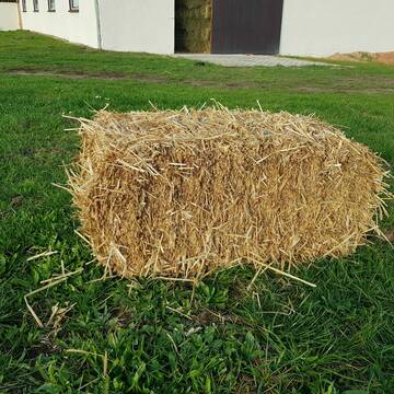
BIO-Heu, 1. Schnitt 2024, Quaderballen (60x40x30)
Tirpersdorf
Forstbaumschule
@Forstbaumschule
Heu
Kleinballen/HD-Ballen
Bio
Regenfrei
Käufer lädt selbst
1 weitere...
aktuell
B+
Deprecated: Creation of dynamic property Zend_View_Helper_Ads::$adLink is deprecated in /var/www/stall-frei/htdocs/staging.stall-frei.de/library/Psf/View/Helper/Ads.php on line 108

Pferdepension Hit Aktivstall Kürmerhof
Hohenkammer
Kuermerhof
@Kuermerhof
*******JETZT NEU MIT ENTSTAUBTEM BIOHEU*********
*******Demnächst mit einem Abenteuerspielplatz für Pferde ( Extrem Trail/Pa
Leider kein Vorschaubild
Leider kein Vorschaubild
Bio-Heu, 1. Schnitt aus 2024 (BIOLAND) zu verkauf.
Tirpersdorf
Forstbaumschule
@Forstbaumschule
Heu
Empfänger lädt ab
Großballen
Bio
Regenfrei
2 weitere...
B+
Leider kein Vorschaubild
Leider kein Vorschaubild
BIO-Heu, 1. Schnitt 2025, Quaderballen (60x40x30)
Tirpersdorf
Forstbaumschule
@Forstbaumschule
Heu
Kleinballen/HD-Ballen
Bio
Regenfrei
Wird verladen
1 weitere...
B+


Futtermittel & Einstreu mit Lieferung!
Schwaara
MK-Agrarprodukte
@MK-Agrarprodukte
Heu
Empfänger lädt ab
Großballen
Regenfrei
2 weitere...
P+


1 Palette Stramofarm Heupellets 30 Sack á 15Kg
Leinefelde
stramofarm GmbH
@stramofarm
Heu
Lieferant entlädt
Pellets
Regenfrei
2 weitere...
P+


1 Palette Stramofarm Strohpellets 30Sack á 25KG
Leinefelde- Worbis
stramofarm GmbH
@stramofarm
Einstreu
Lieferant entlädt
Pellets
Regenfrei
2 weitere...
P+

Luzerneheu 1.Schnitt
Teutschenthal
Nancy
@Haltergemeinschaft-TT
Heu
Empfänger lädt ab
Rundballen
Regenfrei
2 weitere...
B+
HD-Strohballen, Gersten-, Dinkel- und Weizenstroh
Hilpoltstein
KnollmeyerBallen
@KnollmeyerBallen
Einstreu
Lieferant entlädt
Kleinballen/HD-Ballen
Regenfrei
3 weitere...
B+

Heu und Heulage verkaufen
Mechtersen
STALL-FREIde Marketing
@STALL-FREI-Marketing
Verkaufen Sie Ihr Heu und Ihre Heulage direkt an Reiter, Pferdeställe und Reitanlagen

HD-Heuballen, 1. Schnitt & 2. Schnitt
Hilpoltstein
KnollmeyerBallen
@KnollmeyerBallen
Heu
Lieferant entlädt
Kleinballen/HD-Ballen
Regenfrei
3 weitere...
B+

Waldboden Einstreu Lieferung Deutschlandweit
Goldbach
Steigerwald Waldboden Einstreu
@Steigerwald_Waldboden_Einstreu
Einstreu
Lieferant entlädt
Bigbag
Bio
3 weitere...
B+
Deprecated: Creation of dynamic property Zend_View::$pageCount is deprecated in /var/www/stall-frei/htdocs/staging.stall-frei.de/library/vendor/shardj/zf1-future/library/Zend/View/Abstract.php on line 308
Deprecated: Creation of dynamic property Zend_View::$itemCountPerPage is deprecated in /var/www/stall-frei/htdocs/staging.stall-frei.de/library/vendor/shardj/zf1-future/library/Zend/View/Abstract.php on line 308
Deprecated: Creation of dynamic property Zend_View::$first is deprecated in /var/www/stall-frei/htdocs/staging.stall-frei.de/library/vendor/shardj/zf1-future/library/Zend/View/Abstract.php on line 308
Deprecated: Creation of dynamic property Zend_View::$current is deprecated in /var/www/stall-frei/htdocs/staging.stall-frei.de/library/vendor/shardj/zf1-future/library/Zend/View/Abstract.php on line 308
Deprecated: Creation of dynamic property Zend_View::$last is deprecated in /var/www/stall-frei/htdocs/staging.stall-frei.de/library/vendor/shardj/zf1-future/library/Zend/View/Abstract.php on line 308
Deprecated: Creation of dynamic property Zend_View::$next is deprecated in /var/www/stall-frei/htdocs/staging.stall-frei.de/library/vendor/shardj/zf1-future/library/Zend/View/Abstract.php on line 308
Deprecated: Creation of dynamic property Zend_View::$pagesInRange is deprecated in /var/www/stall-frei/htdocs/staging.stall-frei.de/library/vendor/shardj/zf1-future/library/Zend/View/Abstract.php on line 308
Deprecated: Creation of dynamic property Zend_View::$firstPageInRange is deprecated in /var/www/stall-frei/htdocs/staging.stall-frei.de/library/vendor/shardj/zf1-future/library/Zend/View/Abstract.php on line 308
Deprecated: Creation of dynamic property Zend_View::$lastPageInRange is deprecated in /var/www/stall-frei/htdocs/staging.stall-frei.de/library/vendor/shardj/zf1-future/library/Zend/View/Abstract.php on line 308
Deprecated: Creation of dynamic property Zend_View::$currentItemCount is deprecated in /var/www/stall-frei/htdocs/staging.stall-frei.de/library/vendor/shardj/zf1-future/library/Zend/View/Abstract.php on line 308
Deprecated: Creation of dynamic property Zend_View::$totalItemCount is deprecated in /var/www/stall-frei/htdocs/staging.stall-frei.de/library/vendor/shardj/zf1-future/library/Zend/View/Abstract.php on line 308
Deprecated: Creation of dynamic property Zend_View::$firstItemNumber is deprecated in /var/www/stall-frei/htdocs/staging.stall-frei.de/library/vendor/shardj/zf1-future/library/Zend/View/Abstract.php on line 308
Deprecated: Creation of dynamic property Zend_View::$lastItemNumber is deprecated in /var/www/stall-frei/htdocs/staging.stall-frei.de/library/vendor/shardj/zf1-future/library/Zend/View/Abstract.php on line 308
Deprecated: Creation of dynamic property Zend_View::$router is deprecated in /var/www/stall-frei/htdocs/staging.stall-frei.de/library/vendor/shardj/zf1-future/library/Zend/View/Abstract.php on line 308
Deprecated: Creation of dynamic property Zend_View::$urlParams is deprecated in /var/www/stall-frei/htdocs/staging.stall-frei.de/library/vendor/shardj/zf1-future/library/Zend/View/Abstract.php on line 308
Deprecated: Creation of dynamic property Zend_View::$showAds is deprecated in /var/www/stall-frei/htdocs/staging.stall-frei.de/library/vendor/shardj/zf1-future/library/Zend/View/Abstract.php on line 308
Deprecated: Creation of dynamic property Zend_View::$objectIds is deprecated in /var/www/stall-frei/htdocs/staging.stall-frei.de/library/vendor/shardj/zf1-future/library/Zend/View/Abstract.php on line 308
Deprecated: Creation of dynamic property Zend_View::$showNavbar is deprecated in /var/www/stall-frei/htdocs/staging.stall-frei.de/library/vendor/shardj/zf1-future/library/Zend/View/Abstract.php on line 308
Deprecated: Creation of dynamic property Zend_View::$showBreadcrumb is deprecated in /var/www/stall-frei/htdocs/staging.stall-frei.de/library/vendor/shardj/zf1-future/library/Zend/View/Abstract.php on line 308
Deprecated: Creation of dynamic property Zend_View::$showFooter is deprecated in /var/www/stall-frei/htdocs/staging.stall-frei.de/library/vendor/shardj/zf1-future/library/Zend/View/Abstract.php on line 308
Deprecated: Creation of dynamic property Zend_View::$showInternalAds is deprecated in /var/www/stall-frei/htdocs/staging.stall-frei.de/library/vendor/shardj/zf1-future/library/Zend/View/Abstract.php on line 308
Deprecated: Creation of dynamic property Zend_View::$blNoContent is deprecated in /var/www/stall-frei/htdocs/staging.stall-frei.de/library/vendor/shardj/zf1-future/library/Zend/View/Abstract.php on line 308
Deprecated: Creation of dynamic property Zend_View::$sMetaDesc is deprecated in /var/www/stall-frei/htdocs/staging.stall-frei.de/library/vendor/shardj/zf1-future/library/Zend/View/Abstract.php on line 308
Deprecated: Creation of dynamic property Zend_View::$useGmaps is deprecated in /var/www/stall-frei/htdocs/staging.stall-frei.de/library/vendor/shardj/zf1-future/library/Zend/View/Abstract.php on line 308
Deprecated: Creation of dynamic property Zend_View::$touches is deprecated in /var/www/stall-frei/htdocs/staging.stall-frei.de/library/vendor/shardj/zf1-future/library/Zend/View/Abstract.php on line 308
Deprecated: Creation of dynamic property Zend_View::$oProject is deprecated in /var/www/stall-frei/htdocs/staging.stall-frei.de/library/vendor/shardj/zf1-future/library/Zend/View/Abstract.php on line 308
Deprecated: Creation of dynamic property Zend_View::$pageHeadline is deprecated in /var/www/stall-frei/htdocs/staging.stall-frei.de/library/vendor/shardj/zf1-future/library/Zend/View/Abstract.php on line 308
Deprecated: Creation of dynamic property Zend_View::$disableLocationField is deprecated in /var/www/stall-frei/htdocs/staging.stall-frei.de/library/vendor/shardj/zf1-future/library/Zend/View/Abstract.php on line 308
Deprecated: Creation of dynamic property Zend_View::$isSearch is deprecated in /var/www/stall-frei/htdocs/staging.stall-frei.de/library/vendor/shardj/zf1-future/library/Zend/View/Abstract.php on line 308
Deprecated: Creation of dynamic property Zend_View::$pageTitle is deprecated in /var/www/stall-frei/htdocs/staging.stall-frei.de/library/vendor/shardj/zf1-future/library/Zend/View/Abstract.php on line 308
Deprecated: Creation of dynamic property Psf_Form_Element_Text::$class is deprecated in /var/www/stall-frei/htdocs/staging.stall-frei.de/library/vendor/shardj/zf1-future/library/Zend/Form/Element.php on line 874
Deprecated: Creation of dynamic property Psf_Form_Element_Text::$size is deprecated in /var/www/stall-frei/htdocs/staging.stall-frei.de/library/vendor/shardj/zf1-future/library/Zend/Form/Element.php on line 874
Deprecated: Creation of dynamic property Psf_Form_Element_Text::$placeholder is deprecated in /var/www/stall-frei/htdocs/staging.stall-frei.de/library/vendor/shardj/zf1-future/library/Zend/Form/Element.php on line 874
Deprecated: Creation of dynamic property Psf_Form_Element_Hidden::$class is deprecated in /var/www/stall-frei/htdocs/staging.stall-frei.de/library/vendor/shardj/zf1-future/library/Zend/Form/Element.php on line 874
Deprecated: Creation of dynamic property Psf_Form_Element_Hidden::$class is deprecated in /var/www/stall-frei/htdocs/staging.stall-frei.de/library/vendor/shardj/zf1-future/library/Zend/Form/Element.php on line 874
Deprecated: Creation of dynamic property Psf_Form_Element_Hidden::$class is deprecated in /var/www/stall-frei/htdocs/staging.stall-frei.de/library/vendor/shardj/zf1-future/library/Zend/Form/Element.php on line 874
Deprecated: Creation of dynamic property Psf_Form_Element_Hidden::$class is deprecated in /var/www/stall-frei/htdocs/staging.stall-frei.de/library/vendor/shardj/zf1-future/library/Zend/Form/Element.php on line 874
Deprecated: Creation of dynamic property Psf_Form_Element_Select::$class is deprecated in /var/www/stall-frei/htdocs/staging.stall-frei.de/library/vendor/shardj/zf1-future/library/Zend/Form/Element.php on line 874
Deprecated: Creation of dynamic property Psf_Form_Element_Select::$class is deprecated in /var/www/stall-frei/htdocs/staging.stall-frei.de/library/vendor/shardj/zf1-future/library/Zend/Form/Element.php on line 874
Deprecated: Creation of dynamic property Psf_Form_Element_Select::$class is deprecated in /var/www/stall-frei/htdocs/staging.stall-frei.de/library/vendor/shardj/zf1-future/library/Zend/Form/Element.php on line 874
Deprecated: Creation of dynamic property Psf_Form_Element_Select::$class is deprecated in /var/www/stall-frei/htdocs/staging.stall-frei.de/library/vendor/shardj/zf1-future/library/Zend/Form/Element.php on line 874
Deprecated: Creation of dynamic property Zend_View::$sort is deprecated in /var/www/stall-frei/htdocs/staging.stall-frei.de/library/vendor/shardj/zf1-future/library/Zend/View/Abstract.php on line 308
Deprecated: Creation of dynamic property Zend_View::$searchLocation is deprecated in /var/www/stall-frei/htdocs/staging.stall-frei.de/library/vendor/shardj/zf1-future/library/Zend/View/Abstract.php on line 308
Deprecated: Creation of dynamic property Zend_View::$locationHint is deprecated in /var/www/stall-frei/htdocs/staging.stall-frei.de/library/vendor/shardj/zf1-future/library/Zend/View/Abstract.php on line 308
Psf_GeoCoder_Abstract::getLocation: Sonneberg Get Location CachedOrLive
Psf_GeoCoder_Abstract::getCachedOrLive: Sonneberg
Psf_GeoCoder_OpenCageData::makeApiRequest: response:
Array
(
[documentation] => https://opencagedata.com/api
[licenses] => Array
(
[0] => Array
(
[name] => see attribution guide
[url] => https://opencagedata.com/credits
)
)
[results] => Array
(
[0] => Array
(
[bounds] => Array
(
[northeast] => Array
(
[lat] => 50.5075066
[lng] => 11.2847864
)
[southwest] => Array
(
[lat] => 50.3208602
[lng] => 11.1140478
)
)
[components] => Array
(
[ISO_3166-1_alpha-2] => DE
[ISO_3166-1_alpha-3] => DEU
[ISO_3166-2] => Array
(
[0] => DE-TH
)
[_category] => place
[_normalized_city] => Sonneberg
[_type] => city
[continent] => Europe
[country] => Deutschland
[country_code] => de
[county] => Landkreis Sonneberg
[political_union] => European Union
[postcode] => 96515
[state] => Thüringen
[state_code] => TH
[town] => Sonneberg
)
[confidence] => 5
[formatted] => 96515 Sonneberg, Deutschland
[geometry] => Array
(
[lat] => 50.3575412
[lng] => 11.1691714
)
)
[1] => Array
(
[bounds] => Array
(
[northeast] => Array
(
[lat] => 51.0451607
[lng] => 14.5333094
)
[southwest] => Array
(
[lat] => 51.0051607
[lng] => 14.4933094
)
)
[components] => Array
(
[ISO_3166-1_alpha-2] => DE
[ISO_3166-1_alpha-3] => DEU
[ISO_3166-2] => Array
(
[0] => DE-SN
)
[_category] => place
[_normalized_city] => Neusalza-Spremberg
[_type] => village
[continent] => Europe
[country] => Deutschland
[country_code] => de
[county] => Görlitz
[municipality] => Neusalza-Spremberg
[political_union] => European Union
[postcode] => 02742
[state] => Sachsen
[state_code] => SN
[town] => Neusalza-Spremberg
[village] => Sonneberg
)
[confidence] => 7
[formatted] => 02742 Sonneberg, Deutschland
[geometry] => Array
(
[lat] => 51.0251607
[lng] => 14.5133094
)
)
[2] => Array
(
[bounds] => Array
(
[northeast] => Array
(
[lat] => 51.0233665
[lng] => 14.5012997
)
[southwest] => Array
(
[lat] => 51.0232665
[lng] => 14.5011997
)
)
[components] => Array
(
[ISO_3166-1_alpha-2] => DE
[ISO_3166-1_alpha-3] => DEU
[ISO_3166-2] => Array
(
[0] => DE-SN
)
[_category] => natural/water
[_normalized_city] => Neusalza-Spremberg
[_type] => peak
[continent] => Europe
[country] => Deutschland
[country_code] => de
[county] => Görlitz
[municipality] => Neusalza-Spremberg
[peak] => Sonneberg
[political_union] => European Union
[postcode] => 02742
[state] => Sachsen
[state_code] => SN
[town] => Neusalza-Spremberg
)
[confidence] => 9
[formatted] => Sonneberg, 02742 Neusalza-Spremberg, Deutschland
[geometry] => Array
(
[lat] => 51.0233165
[lng] => 14.5012497
)
)
[3] => Array
(
[bounds] => Array
(
[northeast] => Array
(
[lat] => 50.8529614
[lng] => 14.6614711
)
[southwest] => Array
(
[lat] => 50.8528614
[lng] => 14.6613711
)
)
[components] => Array
(
[ISO_3166-1_alpha-2] => DE
[ISO_3166-1_alpha-3] => DEU
[ISO_3166-2] => Array
(
[0] => DE-SN
)
[_category] => natural/water
[_normalized_city] => Jonsdorf
[_type] => peak
[continent] => Europe
[country] => Deutschland
[country_code] => de
[county] => Görlitz
[municipality] => Olbersdorf
[peak] => Sonneberg
[political_union] => European Union
[postcode] => 02799
[state] => Sachsen
[state_code] => SN
[village] => Jonsdorf
)
[confidence] => 9
[formatted] => Sonneberg, 02799 Jonsdorf, Deutschland
[geometry] => Array
(
[lat] => 50.8529114
[lng] => 14.6614211
)
)
[4] => Array
(
[bounds] => Array
(
[northeast] => Array
(
[lat] => 50.4015401
[lng] => 11.1776032
)
[southwest] => Array
(
[lat] => 50.4014401
[lng] => 11.1775032
)
)
[components] => Array
(
[ISO_3166-1_alpha-2] => DE
[ISO_3166-1_alpha-3] => DEU
[ISO_3166-2] => Array
(
[0] => DE-TH
)
[_category] => natural/water
[_normalized_city] => Sonneberg
[_type] => peak
[continent] => Europe
[country] => Deutschland
[country_code] => de
[county] => Landkreis Sonneberg
[peak] => Sonneberg
[political_union] => European Union
[postcode] => 96515
[state] => Thüringen
[state_code] => TH
[town] => Sonneberg
)
[confidence] => 9
[formatted] => Sonneberg, 96515 Sonneberg, Deutschland
[geometry] => Array
(
[lat] => 50.4014901
[lng] => 11.1775532
)
)
[5] => Array
(
[bounds] => Array
(
[northeast] => Array
(
[lat] => 51.0697819
[lng] => 14.7015352
)
[southwest] => Array
(
[lat] => 51.0297819
[lng] => 14.6615352
)
)
[components] => Array
(
[ISO_3166-1_alpha-2] => DE
[ISO_3166-1_alpha-3] => DEU
[ISO_3166-2] => Array
(
[0] => DE-SN
)
[_category] => place
[_normalized_city] => Kottmar
[_type] => hamlet
[city] => Kottmar
[continent] => Europe
[country] => Deutschland
[country_code] => de
[county] => Görlitz
[hamlet] => Sonneberg
[political_union] => European Union
[postcode] => 02708
[state] => Sachsen
[state_code] => SN
[village] => Niedercunnersdorf
)
[confidence] => 7
[formatted] => Sonneberg, 02708 Niedercunnersdorf, Deutschland
[geometry] => Array
(
[lat] => 51.0497819
[lng] => 14.6815352
)
)
[6] => Array
(
[bounds] => Array
(
[northeast] => Array
(
[lat] => 50.5664929
[lng] => 11.2847864
)
[southwest] => Array
(
[lat] => 50.266772
[lng] => 10.9394039
)
)
[components] => Array
(
[ISO_3166-1_alpha-2] => DE
[ISO_3166-1_alpha-3] => DEU
[ISO_3166-2] => Array
(
[0] => DE-TH
)
[_category] => place
[_type] => county
[continent] => Europe
[country] => Deutschland
[country_code] => de
[county] => Landkreis Sonneberg
[political_union] => European Union
[state] => Thüringen
[state_code] => TH
)
[confidence] => 4
[formatted] => Sonneberg, Thüringen, Deutschland
[geometry] => Array
(
[lat] => 50.4166458
[lng] => 11.1133174
)
)
[7] => Array
(
[components] => Array
(
[ISO_3166-1_alpha-2] => FR
[ISO_3166-1_alpha-3] => FRA
[ISO_3166-2] => Array
(
[0] => FR-GES
[1] => FR-6AE
[2] => FR-67
)
[_category] => road
[_normalized_city] => Truchtersheim
[_type] => road
[city] => Truchtersheim
[continent] => Europe
[country] => France
[country_code] => fr
[county] => Bas-Rhin
[local_authority] => Communauté de communes du Kochersberg
[political_union] => European Union
[postcode] => 67370
[road] => Rue du Sonnenberg
[state] => Grand Est
[state_code] => GES
)
[confidence] => 3
[formatted] => Rue du Sonnenberg, 67370 Truchtersheim, France
[geometry] => Array
(
[lat] => 48.666577
[lng] => 7.602796
)
)
[8] => Array
(
[components] => Array
(
[ISO_3166-1_alpha-2] => FR
[ISO_3166-1_alpha-3] => FRA
[ISO_3166-2] => Array
(
[0] => FR-IDF
[1] => FR-92
)
[_category] => road
[_normalized_city] => Levallois-Perret
[_type] => road
[city] => Levallois-Perret
[continent] => Europe
[country] => France
[country_code] => fr
[county] => Hauts-de-Seine
[local_authority] => Métropole du Grand Paris
[political_union] => European Union
[postcode] => 92300
[road] => Rue Charles Deutschmann
[state] => Île-de-France
[state_code] => IDF
)
[confidence] => 2
[formatted] => Rue Charles Deutschmann, 92300 Levallois-Perret, France
[geometry] => Array
(
[lat] => 48.900049
[lng] => 2.2842
)
)
[9] => Array
(
[components] => Array
(
[ISO_3166-1_alpha-2] => FR
[ISO_3166-1_alpha-3] => FRA
[ISO_3166-2] => Array
(
[0] => FR-GES
[1] => FR-6AE
[2] => FR-67
)
[_category] => road
[_normalized_city] => Rangen
[_type] => road
[city] => Rangen
[continent] => Europe
[country] => France
[country_code] => fr
[county] => Bas-Rhin
[local_authority] => Communauté de communes de la Mossig et du Vignoble
[political_union] => European Union
[postcode] => 67310
[road] => Impasse du Sonnenberg
[state] => Grand Est
[state_code] => GES
)
[confidence] => 2
[formatted] => Impasse du Sonnenberg, 67310 Rangen, France
[geometry] => Array
(
[lat] => 48.667462
[lng] => 7.477018
)
)
)
[status] => Array
(
[code] => 200
[message] => OK
)
[stay_informed] => Array
(
[blog] => https://blog.opencagedata.com
[mastodon] => https://en.osm.town/@opencage
)
[thanks] => For using an OpenCage API
[timestamp] => Array
(
[created_http] => Mon, 09 Feb 2026 03:14:18 GMT
[created_unix] => 1770606858
)
[total_results] => 10
)
Psf_GeoCoder_Abstract::convertLocationResult
{"documentation":"https:\/\/opencagedata.com\/api","licenses":[{"name":"see attribution guide","url":"https:\/\/opencagedata.com\/credits"}],"results":[{"bounds":{"northeast":{"lat":50.5075066,"lng":11.2847864},"southwest":{"lat":50.3208602,"lng":11.1140478}},"components":{"ISO_3166-1_alpha-2":"DE","ISO_3166-1_alpha-3":"DEU","ISO_3166-2":["DE-TH"],"_category":"place","_normalized_city":"Sonneberg","_type":"city","continent":"Europe","country":"Deutschland","country_code":"de","county":"Landkreis Sonneberg","political_union":"European Union","postcode":"96515","state":"Th\u00fcringen","state_code":"TH","town":"Sonneberg"},"confidence":5,"formatted":"96515 Sonneberg, Deutschland","geometry":{"lat":50.3575412,"lng":11.1691714}},{"bounds":{"northeast":{"lat":51.0451607,"lng":14.5333094},"southwest":{"lat":51.0051607,"lng":14.4933094}},"components":{"ISO_3166-1_alpha-2":"DE","ISO_3166-1_alpha-3":"DEU","ISO_3166-2":["DE-SN"],"_category":"place","_normalized_city":"Neusalza-Spremberg","_type":"village","continent":"Europe","country":"Deutschland","country_code":"de","county":"G\u00f6rlitz","municipality":"Neusalza-Spremberg","political_union":"European Union","postcode":"02742","state":"Sachsen","state_code":"SN","town":"Neusalza-Spremberg","village":"Sonneberg"},"confidence":7,"formatted":"02742 Sonneberg, Deutschland","geometry":{"lat":51.0251607,"lng":14.5133094}},{"bounds":{"northeast":{"lat":51.0233665,"lng":14.5012997},"southwest":{"lat":51.0232665,"lng":14.5011997}},"components":{"ISO_3166-1_alpha-2":"DE","ISO_3166-1_alpha-3":"DEU","ISO_3166-2":["DE-SN"],"_category":"natural\/water","_normalized_city":"Neusalza-Spremberg","_type":"peak","continent":"Europe","country":"Deutschland","country_code":"de","county":"G\u00f6rlitz","municipality":"Neusalza-Spremberg","peak":"Sonneberg","political_union":"European Union","postcode":"02742","state":"Sachsen","state_code":"SN","town":"Neusalza-Spremberg"},"confidence":9,"formatted":"Sonneberg, 02742 Neusalza-Spremberg, Deutschland","geometry":{"lat":51.0233165,"lng":14.5012497}},{"bounds":{"northeast":{"lat":50.8529614,"lng":14.6614711},"southwest":{"lat":50.8528614,"lng":14.6613711}},"components":{"ISO_3166-1_alpha-2":"DE","ISO_3166-1_alpha-3":"DEU","ISO_3166-2":["DE-SN"],"_category":"natural\/water","_normalized_city":"Jonsdorf","_type":"peak","continent":"Europe","country":"Deutschland","country_code":"de","county":"G\u00f6rlitz","municipality":"Olbersdorf","peak":"Sonneberg","political_union":"European Union","postcode":"02799","state":"Sachsen","state_code":"SN","village":"Jonsdorf"},"confidence":9,"formatted":"Sonneberg, 02799 Jonsdorf, Deutschland","geometry":{"lat":50.8529114,"lng":14.6614211}},{"bounds":{"northeast":{"lat":50.4015401,"lng":11.1776032},"southwest":{"lat":50.4014401,"lng":11.1775032}},"components":{"ISO_3166-1_alpha-2":"DE","ISO_3166-1_alpha-3":"DEU","ISO_3166-2":["DE-TH"],"_category":"natural\/water","_normalized_city":"Sonneberg","_type":"peak","continent":"Europe","country":"Deutschland","country_code":"de","county":"Landkreis Sonneberg","peak":"Sonneberg","political_union":"European Union","postcode":"96515","state":"Th\u00fcringen","state_code":"TH","town":"Sonneberg"},"confidence":9,"formatted":"Sonneberg, 96515 Sonneberg, Deutschland","geometry":{"lat":50.4014901,"lng":11.1775532}},{"bounds":{"northeast":{"lat":51.0697819,"lng":14.7015352},"southwest":{"lat":51.0297819,"lng":14.6615352}},"components":{"ISO_3166-1_alpha-2":"DE","ISO_3166-1_alpha-3":"DEU","ISO_3166-2":["DE-SN"],"_category":"place","_normalized_city":"Kottmar","_type":"hamlet","city":"Kottmar","continent":"Europe","country":"Deutschland","country_code":"de","county":"G\u00f6rlitz","hamlet":"Sonneberg","political_union":"European Union","postcode":"02708","state":"Sachsen","state_code":"SN","village":"Niedercunnersdorf"},"confidence":7,"formatted":"Sonneberg, 02708 Niedercunnersdorf, Deutschland","geometry":{"lat":51.0497819,"lng":14.6815352}},{"bounds":{"northeast":{"lat":50.5664929,"lng":11.2847864},"southwest":{"lat":50.266772,"lng":10.9394039}},"components":{"ISO_3166-1_alpha-2":"DE","ISO_3166-1_alpha-3":"DEU","ISO_3166-2":["DE-TH"],"_category":"place","_type":"county","continent":"Europe","country":"Deutschland","country_code":"de","county":"Landkreis Sonneberg","political_union":"European Union","state":"Th\u00fcringen","state_code":"TH"},"confidence":4,"formatted":"Sonneberg, Th\u00fcringen, Deutschland","geometry":{"lat":50.4166458,"lng":11.1133174}},{"components":{"ISO_3166-1_alpha-2":"FR","ISO_3166-1_alpha-3":"FRA","ISO_3166-2":["FR-GES","FR-6AE","FR-67"],"_category":"road","_normalized_city":"Truchtersheim","_type":"road","city":"Truchtersheim","continent":"Europe","country":"France","country_code":"fr","county":"Bas-Rhin","local_authority":"Communaut\u00e9 de communes du Kochersberg","political_union":"European Union","postcode":"67370","road":"Rue du Sonnenberg","state":"Grand Est","state_code":"GES"},"confidence":3,"formatted":"Rue du Sonnenberg, 67370 Truchtersheim, France","geometry":{"lat":48.666577,"lng":7.602796}},{"components":{"ISO_3166-1_alpha-2":"FR","ISO_3166-1_alpha-3":"FRA","ISO_3166-2":["FR-IDF","FR-92"],"_category":"road","_normalized_city":"Levallois-Perret","_type":"road","city":"Levallois-Perret","continent":"Europe","country":"France","country_code":"fr","county":"Hauts-de-Seine","local_authority":"M\u00e9tropole du Grand Paris","political_union":"European Union","postcode":"92300","road":"Rue Charles Deutschmann","state":"\u00cele-de-France","state_code":"IDF"},"confidence":2,"formatted":"Rue Charles Deutschmann, 92300 Levallois-Perret, France","geometry":{"lat":48.900049,"lng":2.2842}},{"components":{"ISO_3166-1_alpha-2":"FR","ISO_3166-1_alpha-3":"FRA","ISO_3166-2":["FR-GES","FR-6AE","FR-67"],"_category":"road","_normalized_city":"Rangen","_type":"road","city":"Rangen","continent":"Europe","country":"France","country_code":"fr","county":"Bas-Rhin","local_authority":"Communaut\u00e9 de communes de la Mossig et du Vignoble","political_union":"European Union","postcode":"67310","road":"Impasse du Sonnenberg","state":"Grand Est","state_code":"GES"},"confidence":2,"formatted":"Impasse du Sonnenberg, 67310 Rangen, France","geometry":{"lat":48.667462,"lng":7.477018}}],"status":{"code":200,"message":"OK"},"stay_informed":{"blog":"https:\/\/blog.opencagedata.com","mastodon":"https:\/\/en.osm.town\/@opencage"},"thanks":"For using an OpenCage API","timestamp":{"created_http":"Mon, 09 Feb 2026 03:14:18 GMT","created_unix":1770606858},"total_results":10}Array
(
[0] => stdClass Object
(
[bounds] => stdClass Object
(
[northeast] => stdClass Object
(
[lat] => 50.5075066
[lng] => 11.2847864
)
[southwest] => stdClass Object
(
[lat] => 50.3208602
[lng] => 11.1140478
)
)
[components] => stdClass Object
(
[ISO_3166-1_alpha-2] => DE
[ISO_3166-1_alpha-3] => DEU
[ISO_3166-2] => Array
(
[0] => DE-TH
)
[_category] => place
[_normalized_city] => Sonneberg
[_type] => city
[continent] => Europe
[country] => Deutschland
[country_code] => de
[county] => Landkreis Sonneberg
[political_union] => European Union
[postcode] => 96515
[state] => Thüringen
[state_code] => TH
[town] => Sonneberg
)
[confidence] => 5
[formatted] => 96515 Sonneberg, Deutschland
[geometry] => stdClass Object
(
[lat] => 50.3575412
[lng] => 11.1691714
)
)
[1] => stdClass Object
(
[bounds] => stdClass Object
(
[northeast] => stdClass Object
(
[lat] => 51.0451607
[lng] => 14.5333094
)
[southwest] => stdClass Object
(
[lat] => 51.0051607
[lng] => 14.4933094
)
)
[components] => stdClass Object
(
[ISO_3166-1_alpha-2] => DE
[ISO_3166-1_alpha-3] => DEU
[ISO_3166-2] => Array
(
[0] => DE-SN
)
[_category] => place
[_normalized_city] => Neusalza-Spremberg
[_type] => village
[continent] => Europe
[country] => Deutschland
[country_code] => de
[county] => Görlitz
[municipality] => Neusalza-Spremberg
[political_union] => European Union
[postcode] => 02742
[state] => Sachsen
[state_code] => SN
[town] => Neusalza-Spremberg
[village] => Sonneberg
)
[confidence] => 7
[formatted] => 02742 Sonneberg, Deutschland
[geometry] => stdClass Object
(
[lat] => 51.0251607
[lng] => 14.5133094
)
)
[2] => stdClass Object
(
[bounds] => stdClass Object
(
[northeast] => stdClass Object
(
[lat] => 51.0233665
[lng] => 14.5012997
)
[southwest] => stdClass Object
(
[lat] => 51.0232665
[lng] => 14.5011997
)
)
[components] => stdClass Object
(
[ISO_3166-1_alpha-2] => DE
[ISO_3166-1_alpha-3] => DEU
[ISO_3166-2] => Array
(
[0] => DE-SN
)
[_category] => natural/water
[_normalized_city] => Neusalza-Spremberg
[_type] => peak
[continent] => Europe
[country] => Deutschland
[country_code] => de
[county] => Görlitz
[municipality] => Neusalza-Spremberg
[peak] => Sonneberg
[political_union] => European Union
[postcode] => 02742
[state] => Sachsen
[state_code] => SN
[town] => Neusalza-Spremberg
)
[confidence] => 9
[formatted] => Sonneberg, 02742 Neusalza-Spremberg, Deutschland
[geometry] => stdClass Object
(
[lat] => 51.0233165
[lng] => 14.5012497
)
)
[3] => stdClass Object
(
[bounds] => stdClass Object
(
[northeast] => stdClass Object
(
[lat] => 50.8529614
[lng] => 14.6614711
)
[southwest] => stdClass Object
(
[lat] => 50.8528614
[lng] => 14.6613711
)
)
[components] => stdClass Object
(
[ISO_3166-1_alpha-2] => DE
[ISO_3166-1_alpha-3] => DEU
[ISO_3166-2] => Array
(
[0] => DE-SN
)
[_category] => natural/water
[_normalized_city] => Jonsdorf
[_type] => peak
[continent] => Europe
[country] => Deutschland
[country_code] => de
[county] => Görlitz
[municipality] => Olbersdorf
[peak] => Sonneberg
[political_union] => European Union
[postcode] => 02799
[state] => Sachsen
[state_code] => SN
[village] => Jonsdorf
)
[confidence] => 9
[formatted] => Sonneberg, 02799 Jonsdorf, Deutschland
[geometry] => stdClass Object
(
[lat] => 50.8529114
[lng] => 14.6614211
)
)
[4] => stdClass Object
(
[bounds] => stdClass Object
(
[northeast] => stdClass Object
(
[lat] => 50.4015401
[lng] => 11.1776032
)
[southwest] => stdClass Object
(
[lat] => 50.4014401
[lng] => 11.1775032
)
)
[components] => stdClass Object
(
[ISO_3166-1_alpha-2] => DE
[ISO_3166-1_alpha-3] => DEU
[ISO_3166-2] => Array
(
[0] => DE-TH
)
[_category] => natural/water
[_normalized_city] => Sonneberg
[_type] => peak
[continent] => Europe
[country] => Deutschland
[country_code] => de
[county] => Landkreis Sonneberg
[peak] => Sonneberg
[political_union] => European Union
[postcode] => 96515
[state] => Thüringen
[state_code] => TH
[town] => Sonneberg
)
[confidence] => 9
[formatted] => Sonneberg, 96515 Sonneberg, Deutschland
[geometry] => stdClass Object
(
[lat] => 50.4014901
[lng] => 11.1775532
)
)
[5] => stdClass Object
(
[bounds] => stdClass Object
(
[northeast] => stdClass Object
(
[lat] => 51.0697819
[lng] => 14.7015352
)
[southwest] => stdClass Object
(
[lat] => 51.0297819
[lng] => 14.6615352
)
)
[components] => stdClass Object
(
[ISO_3166-1_alpha-2] => DE
[ISO_3166-1_alpha-3] => DEU
[ISO_3166-2] => Array
(
[0] => DE-SN
)
[_category] => place
[_normalized_city] => Kottmar
[_type] => hamlet
[city] => Kottmar
[continent] => Europe
[country] => Deutschland
[country_code] => de
[county] => Görlitz
[hamlet] => Sonneberg
[political_union] => European Union
[postcode] => 02708
[state] => Sachsen
[state_code] => SN
[village] => Niedercunnersdorf
)
[confidence] => 7
[formatted] => Sonneberg, 02708 Niedercunnersdorf, Deutschland
[geometry] => stdClass Object
(
[lat] => 51.0497819
[lng] => 14.6815352
)
)
[6] => stdClass Object
(
[bounds] => stdClass Object
(
[northeast] => stdClass Object
(
[lat] => 50.5664929
[lng] => 11.2847864
)
[southwest] => stdClass Object
(
[lat] => 50.266772
[lng] => 10.9394039
)
)
[components] => stdClass Object
(
[ISO_3166-1_alpha-2] => DE
[ISO_3166-1_alpha-3] => DEU
[ISO_3166-2] => Array
(
[0] => DE-TH
)
[_category] => place
[_type] => county
[continent] => Europe
[country] => Deutschland
[country_code] => de
[county] => Landkreis Sonneberg
[political_union] => European Union
[state] => Thüringen
[state_code] => TH
)
[confidence] => 4
[formatted] => Sonneberg, Thüringen, Deutschland
[geometry] => stdClass Object
(
[lat] => 50.4166458
[lng] => 11.1133174
)
)
[7] => stdClass Object
(
[components] => stdClass Object
(
[ISO_3166-1_alpha-2] => FR
[ISO_3166-1_alpha-3] => FRA
[ISO_3166-2] => Array
(
[0] => FR-GES
[1] => FR-6AE
[2] => FR-67
)
[_category] => road
[_normalized_city] => Truchtersheim
[_type] => road
[city] => Truchtersheim
[continent] => Europe
[country] => France
[country_code] => fr
[county] => Bas-Rhin
[local_authority] => Communauté de communes du Kochersberg
[political_union] => European Union
[postcode] => 67370
[road] => Rue du Sonnenberg
[state] => Grand Est
[state_code] => GES
)
[confidence] => 3
[formatted] => Rue du Sonnenberg, 67370 Truchtersheim, France
[geometry] => stdClass Object
(
[lat] => 48.666577
[lng] => 7.602796
)
)
[8] => stdClass Object
(
[components] => stdClass Object
(
[ISO_3166-1_alpha-2] => FR
[ISO_3166-1_alpha-3] => FRA
[ISO_3166-2] => Array
(
[0] => FR-IDF
[1] => FR-92
)
[_category] => road
[_normalized_city] => Levallois-Perret
[_type] => road
[city] => Levallois-Perret
[continent] => Europe
[country] => France
[country_code] => fr
[county] => Hauts-de-Seine
[local_authority] => Métropole du Grand Paris
[political_union] => European Union
[postcode] => 92300
[road] => Rue Charles Deutschmann
[state] => Île-de-France
[state_code] => IDF
)
[confidence] => 2
[formatted] => Rue Charles Deutschmann, 92300 Levallois-Perret, France
[geometry] => stdClass Object
(
[lat] => 48.900049
[lng] => 2.2842
)
)
[9] => stdClass Object
(
[components] => stdClass Object
(
[ISO_3166-1_alpha-2] => FR
[ISO_3166-1_alpha-3] => FRA
[ISO_3166-2] => Array
(
[0] => FR-GES
[1] => FR-6AE
[2] => FR-67
)
[_category] => road
[_normalized_city] => Rangen
[_type] => road
[city] => Rangen
[continent] => Europe
[country] => France
[country_code] => fr
[county] => Bas-Rhin
[local_authority] => Communauté de communes de la Mossig et du Vignoble
[political_union] => European Union
[postcode] => 67310
[road] => Impasse du Sonnenberg
[state] => Grand Est
[state_code] => GES
)
[confidence] => 2
[formatted] => Impasse du Sonnenberg, 67310 Rangen, France
[geometry] => stdClass Object
(
[lat] => 48.667462
[lng] => 7.477018
)
)
)
Psf_GeoCoder_OpenCageData::getKeyMap: 0
stdClass Object
(
    [bounds] => stdClass Object
        (
            [northeast] => stdClass Object
                (
                    [lat] => 50.5075066
                    [lng] => 11.2847864
                )

            [southwest] => stdClass Object
                (
                    [lat] => 50.3208602
                    [lng] => 11.1140478
                )

        )

    [components] => stdClass Object
        (
            [ISO_3166-1_alpha-2] => DE
            [ISO_3166-1_alpha-3] => DEU
            [ISO_3166-2] => Array
                (
                    [0] => DE-TH
                )

            [_category] => place
            [_normalized_city] => Sonneberg
            [_type] => city
            [continent] => Europe
            [country] => Deutschland
            [country_code] => de
            [county] => Landkreis Sonneberg
            [political_union] => European Union
            [postcode] => 96515
            [state] => Thüringen
            [state_code] => TH
            [town] => Sonneberg
        )

    [confidence] => 5
    [formatted] => 96515 Sonneberg, Deutschland
    [geometry] => stdClass Object
        (
            [lat] => 50.3575412
            [lng] => 11.1691714
        )

)
Psf_GeoCoder_OpenCageData::getCounty: Sonneberg
Psf_GeoCoder_OpenCageData::addMissingData REFETCH!
Array
(
    [address] => 96515 Sonneberg, Deutschland
    [type] => city
    [street] =>
    [city] => Sonneberg
    [county] => Sonneberg
    [state] => Thüringen
    [zip] => 96515
    [country] => Deutschland
    [suburb] =>
    [countrycode] => de
    [latitude] => 50.3575412
    [longitude] => 11.1691714
    [accuracy] => 1
    [confidence] => 5
    [bounds] => stdClass Object
        (
            [northeast] => stdClass Object
                (
                    [lat] => 50.5075066
                    [lng] => 11.2847864
                )

            [southwest] => stdClass Object
                (
                    [lat] => 50.3208602
                    [lng] => 11.1140478
                )

        )

)
reformat!
Array
(
    [address] => 96515 Sonneberg, Deutschland
    [type] => city
    [street] =>
    [city] => Sonneberg
    [county] => Sonneberg
    [state] => Thüringen
    [zip] => 96515
    [country] => Deutschland
    [suburb] =>
    [countrycode] => de
    [latitude] => 50.3575412
    [longitude] => 11.1691714
    [accuracy] => 1
    [confidence] => 5
    [bounds] => stdClass Object
        (
            [northeast] => stdClass Object
                (
                    [lat] => 50.5075066
                    [lng] => 11.2847864
                )

            [southwest] => stdClass Object
                (
                    [lat] => 50.3208602
                    [lng] => 11.1140478
                )

        )

    [place] => 96515 Sonneberg, Thüringen
    [hash] => 0c2531fa3c0bcacc8f706039939292eb
)
Psf_GeoCoder_OpenCageData::getKeyMap: 1
stdClass Object
(
    [bounds] => stdClass Object
        (
            [northeast] => stdClass Object
                (
                    [lat] => 51.0451607
                    [lng] => 14.5333094
                )

            [southwest] => stdClass Object
                (
                    [lat] => 51.0051607
                    [lng] => 14.4933094
                )

        )

    [components] => stdClass Object
        (
            [ISO_3166-1_alpha-2] => DE
            [ISO_3166-1_alpha-3] => DEU
            [ISO_3166-2] => Array
                (
                    [0] => DE-SN
                )

            [_category] => place
            [_normalized_city] => Neusalza-Spremberg
            [_type] => village
            [continent] => Europe
            [country] => Deutschland
            [country_code] => de
            [county] => Görlitz
            [municipality] => Neusalza-Spremberg
            [political_union] => European Union
            [postcode] => 02742
            [state] => Sachsen
            [state_code] => SN
            [town] => Neusalza-Spremberg
            [village] => Sonneberg
        )

    [confidence] => 7
    [formatted] => 02742 Sonneberg, Deutschland
    [geometry] => stdClass Object
        (
            [lat] => 51.0251607
            [lng] => 14.5133094
        )

)
Psf_GeoCoder_OpenCageData::getCounty: Görlitz
Psf_GeoCoder_OpenCageData::addMissingData REFETCH!
Array
(
    [address] => 02742 Sonneberg, Deutschland
    [type] => village
    [street] =>
    [city] => Neusalza-Spremberg
    [county] => Görlitz
    [state] => Sachsen
    [zip] => 02742
    [country] => Deutschland
    [suburb] =>
    [countrycode] => de
    [latitude] => 51.0251607
    [longitude] => 14.5133094
    [accuracy] => 1
    [confidence] => 7
    [bounds] => stdClass Object
        (
            [northeast] => stdClass Object
                (
                    [lat] => 51.0451607
                    [lng] => 14.5333094
                )

            [southwest] => stdClass Object
                (
                    [lat] => 51.0051607
                    [lng] => 14.4933094
                )

        )

)
reformat!
Array
(
    [address] => 02742 Neusalza-Spremberg
    [type] => village
    [street] =>
    [city] => Neusalza-Spremberg
    [county] => Görlitz
    [state] => Sachsen
    [zip] => 02742
    [country] => Deutschland
    [suburb] =>
    [countrycode] => de
    [latitude] => 51.0251607
    [longitude] => 14.5133094
    [accuracy] => 1
    [confidence] => 7
    [bounds] => stdClass Object
        (
            [northeast] => stdClass Object
                (
                    [lat] => 51.0451607
                    [lng] => 14.5333094
                )

            [southwest] => stdClass Object
                (
                    [lat] => 51.0051607
                    [lng] => 14.4933094
                )

        )

    [place] => 02742 Neusalza-Spremberg, Sachsen
    [hash] => 7a653938982d4faea17638a0e270ade6
)
Psf_GeoCoder_OpenCageData::getKeyMap: 2
stdClass Object
(
    [bounds] => stdClass Object
        (
            [northeast] => stdClass Object
                (
                    [lat] => 51.0233665
                    [lng] => 14.5012997
                )

            [southwest] => stdClass Object
                (
                    [lat] => 51.0232665
                    [lng] => 14.5011997
                )

        )

    [components] => stdClass Object
        (
            [ISO_3166-1_alpha-2] => DE
            [ISO_3166-1_alpha-3] => DEU
            [ISO_3166-2] => Array
                (
                    [0] => DE-SN
                )

            [_category] => natural/water
            [_normalized_city] => Neusalza-Spremberg
            [_type] => peak
            [continent] => Europe
            [country] => Deutschland
            [country_code] => de
            [county] => Görlitz
            [municipality] => Neusalza-Spremberg
            [peak] => Sonneberg
            [political_union] => European Union
            [postcode] => 02742
            [state] => Sachsen
            [state_code] => SN
            [town] => Neusalza-Spremberg
        )

    [confidence] => 9
    [formatted] => Sonneberg, 02742 Neusalza-Spremberg, Deutschland
    [geometry] => stdClass Object
        (
            [lat] => 51.0233165
            [lng] => 14.5012497
        )

)
Psf_GeoCoder_OpenCageData::getCounty: Görlitz
Psf_GeoCoder_OpenCageData::addMissingData REFETCH!
Array
(
    [address] => Sonneberg, 02742 Neusalza-Spremberg, Deutschland
    [type] => peak
    [street] =>
    [city] => Neusalza-Spremberg
    [county] => Görlitz
    [state] => Sachsen
    [zip] => 02742
    [country] => Deutschland
    [suburb] =>
    [countrycode] => de
    [latitude] => 51.0233165
    [longitude] => 14.5012497
    [accuracy] => 1
    [confidence] => 9
    [bounds] => stdClass Object
        (
            [northeast] => stdClass Object
                (
                    [lat] => 51.0233665
                    [lng] => 14.5012997
                )

            [southwest] => stdClass Object
                (
                    [lat] => 51.0232665
                    [lng] => 14.5011997
                )

        )

)
reformat!
Array
(
    [address] => Sonneberg, 02742 Neusalza-Spremberg, Deutschland
    [type] => peak
    [street] =>
    [city] => Neusalza-Spremberg
    [county] => Görlitz
    [state] => Sachsen
    [zip] => 02742
    [country] => Deutschland
    [suburb] =>
    [countrycode] => de
    [latitude] => 51.0233165
    [longitude] => 14.5012497
    [accuracy] => 1
    [confidence] => 9
    [bounds] => stdClass Object
        (
            [northeast] => stdClass Object
                (
                    [lat] => 51.0233665
                    [lng] => 14.5012997
                )

            [southwest] => stdClass Object
                (
                    [lat] => 51.0232665
                    [lng] => 14.5011997
                )

        )

    [place] => 02742 Neusalza-Spremberg, Sachsen
    [hash] => 7a653938982d4faea17638a0e270ade6
)
Psf_GeoCoder_OpenCageData::getKeyMap: 3
stdClass Object
(
    [bounds] => stdClass Object
        (
            [northeast] => stdClass Object
                (
                    [lat] => 50.8529614
                    [lng] => 14.6614711
                )

            [southwest] => stdClass Object
                (
                    [lat] => 50.8528614
                    [lng] => 14.6613711
                )

        )

    [components] => stdClass Object
        (
            [ISO_3166-1_alpha-2] => DE
            [ISO_3166-1_alpha-3] => DEU
            [ISO_3166-2] => Array
                (
                    [0] => DE-SN
                )

            [_category] => natural/water
            [_normalized_city] => Jonsdorf
            [_type] => peak
            [continent] => Europe
            [country] => Deutschland
            [country_code] => de
            [county] => Görlitz
            [municipality] => Olbersdorf
            [peak] => Sonneberg
            [political_union] => European Union
            [postcode] => 02799
            [state] => Sachsen
            [state_code] => SN
            [village] => Jonsdorf
        )

    [confidence] => 9
    [formatted] => Sonneberg, 02799 Jonsdorf, Deutschland
    [geometry] => stdClass Object
        (
            [lat] => 50.8529114
            [lng] => 14.6614211
        )

)
Psf_GeoCoder_OpenCageData::getCounty: Görlitz
Psf_GeoCoder_OpenCageData::addMissingData REFETCH!
Array
(
    [address] => Sonneberg, 02799 Jonsdorf, Deutschland
    [type] => peak
    [street] =>
    [city] => Jonsdorf
    [county] => Görlitz
    [state] => Sachsen
    [zip] => 02799
    [country] => Deutschland
    [suburb] =>
    [countrycode] => de
    [latitude] => 50.8529114
    [longitude] => 14.6614211
    [accuracy] => 1
    [confidence] => 9
    [bounds] => stdClass Object
        (
            [northeast] => stdClass Object
                (
                    [lat] => 50.8529614
                    [lng] => 14.6614711
                )

            [southwest] => stdClass Object
                (
                    [lat] => 50.8528614
                    [lng] => 14.6613711
                )

        )

)
reformat!
Array
(
    [address] => Sonneberg, 02799 Jonsdorf, Deutschland
    [type] => peak
    [street] =>
    [city] => Jonsdorf
    [county] => Görlitz
    [state] => Sachsen
    [zip] => 02799
    [country] => Deutschland
    [suburb] =>
    [countrycode] => de
    [latitude] => 50.8529114
    [longitude] => 14.6614211
    [accuracy] => 1
    [confidence] => 9
    [bounds] => stdClass Object
        (
            [northeast] => stdClass Object
                (
                    [lat] => 50.8529614
                    [lng] => 14.6614711
                )

            [southwest] => stdClass Object
                (
                    [lat] => 50.8528614
                    [lng] => 14.6613711
                )

        )

    [place] => 02799 Jonsdorf, Sachsen
    [hash] => 260bfb99d5c07070b60226aab636b8e8
)
Psf_GeoCoder_OpenCageData::getKeyMap: 4
stdClass Object
(
    [bounds] => stdClass Object
        (
            [northeast] => stdClass Object
                (
                    [lat] => 50.4015401
                    [lng] => 11.1776032
                )

            [southwest] => stdClass Object
                (
                    [lat] => 50.4014401
                    [lng] => 11.1775032
                )

        )

    [components] => stdClass Object
        (
            [ISO_3166-1_alpha-2] => DE
            [ISO_3166-1_alpha-3] => DEU
            [ISO_3166-2] => Array
                (
                    [0] => DE-TH
                )

            [_category] => natural/water
            [_normalized_city] => Sonneberg
            [_type] => peak
            [continent] => Europe
            [country] => Deutschland
            [country_code] => de
            [county] => Landkreis Sonneberg
            [peak] => Sonneberg
            [political_union] => European Union
            [postcode] => 96515
            [state] => Thüringen
            [state_code] => TH
            [town] => Sonneberg
        )

    [confidence] => 9
    [formatted] => Sonneberg, 96515 Sonneberg, Deutschland
    [geometry] => stdClass Object
        (
            [lat] => 50.4014901
            [lng] => 11.1775532
        )

)
Psf_GeoCoder_OpenCageData::getCounty: Sonneberg
Psf_GeoCoder_OpenCageData::addMissingData REFETCH!
Array
(
    [address] => Sonneberg, 96515 Sonneberg, Deutschland
    [type] => peak
    [street] =>
    [city] => Sonneberg
    [county] => Sonneberg
    [state] => Thüringen
    [zip] => 96515
    [country] => Deutschland
    [suburb] =>
    [countrycode] => de
    [latitude] => 50.4014901
    [longitude] => 11.1775532
    [accuracy] => 1
    [confidence] => 9
    [bounds] => stdClass Object
        (
            [northeast] => stdClass Object
                (
                    [lat] => 50.4015401
                    [lng] => 11.1776032
                )

            [southwest] => stdClass Object
                (
                    [lat] => 50.4014401
                    [lng] => 11.1775032
                )

        )

)
reformat!
Array
(
    [address] => Sonneberg, 96515 Sonneberg, Deutschland
    [type] => peak
    [street] =>
    [city] => Sonneberg
    [county] => Sonneberg
    [state] => Thüringen
    [zip] => 96515
    [country] => Deutschland
    [suburb] =>
    [countrycode] => de
    [latitude] => 50.4014901
    [longitude] => 11.1775532
    [accuracy] => 1
    [confidence] => 9
    [bounds] => stdClass Object
        (
            [northeast] => stdClass Object
                (
                    [lat] => 50.4015401
                    [lng] => 11.1776032
                )

            [southwest] => stdClass Object
                (
                    [lat] => 50.4014401
                    [lng] => 11.1775032
                )

        )

    [place] => 96515 Sonneberg, Thüringen
    [hash] => 0c2531fa3c0bcacc8f706039939292eb
)
Psf_GeoCoder_OpenCageData::getKeyMap: 5
stdClass Object
(
    [bounds] => stdClass Object
        (
            [northeast] => stdClass Object
                (
                    [lat] => 51.0697819
                    [lng] => 14.7015352
                )

            [southwest] => stdClass Object
                (
                    [lat] => 51.0297819
                    [lng] => 14.6615352
                )

        )

    [components] => stdClass Object
        (
            [ISO_3166-1_alpha-2] => DE
            [ISO_3166-1_alpha-3] => DEU
            [ISO_3166-2] => Array
                (
                    [0] => DE-SN
                )

            [_category] => place
            [_normalized_city] => Kottmar
            [_type] => hamlet
            [city] => Kottmar
            [continent] => Europe
            [country] => Deutschland
            [country_code] => de
            [county] => Görlitz
            [hamlet] => Sonneberg
            [political_union] => European Union
            [postcode] => 02708
            [state] => Sachsen
            [state_code] => SN
            [village] => Niedercunnersdorf
        )

    [confidence] => 7
    [formatted] => Sonneberg, 02708 Niedercunnersdorf, Deutschland
    [geometry] => stdClass Object
        (
            [lat] => 51.0497819
            [lng] => 14.6815352
        )

)
Psf_GeoCoder_OpenCageData::getCounty: Görlitz
Psf_GeoCoder_OpenCageData::addMissingData REFETCH!
Array
(
    [address] => Sonneberg, 02708 Niedercunnersdorf, Deutschland
    [type] => hamlet
    [street] => Sonneberg
    [city] => Niedercunnersdorf
    [county] => Görlitz
    [state] => Sachsen
    [zip] => 02708
    [country] => Deutschland
    [suburb] =>
    [countrycode] => de
    [latitude] => 51.0497819
    [longitude] => 14.6815352
    [accuracy] => 1
    [confidence] => 7
    [bounds] => stdClass Object
        (
            [northeast] => stdClass Object
                (
                    [lat] => 51.0697819
                    [lng] => 14.7015352
                )

            [southwest] => stdClass Object
                (
                    [lat] => 51.0297819
                    [lng] => 14.6615352
                )

        )

)
reformat!
Array
(
    [address] => Sonneberg, 02708 Niedercunnersdorf, Deutschland
    [type] => hamlet
    [street] => Sonneberg
    [city] => Niedercunnersdorf
    [county] => Görlitz
    [state] => Sachsen
    [zip] => 02708
    [country] => Deutschland
    [suburb] =>
    [countrycode] => de
    [latitude] => 51.0497819
    [longitude] => 14.6815352
    [accuracy] => 1
    [confidence] => 7
    [bounds] => stdClass Object
        (
            [northeast] => stdClass Object
                (
                    [lat] => 51.0697819
                    [lng] => 14.7015352
                )

            [southwest] => stdClass Object
                (
                    [lat] => 51.0297819
                    [lng] => 14.6615352
                )

        )

    [place] => Sonneberg, 02708 Niedercunnersdorf, Sachsen
    [hash] => a6d0d246c6c4b96cf80cd3f74b89eecc
)
Psf_GeoCoder_OpenCageData::getKeyMap: 6
stdClass Object
(
    [bounds] => stdClass Object
        (
            [northeast] => stdClass Object
                (
                    [lat] => 50.5664929
                    [lng] => 11.2847864
                )

            [southwest] => stdClass Object
                (
                    [lat] => 50.266772
                    [lng] => 10.9394039
                )

        )

    [components] => stdClass Object
        (
            [ISO_3166-1_alpha-2] => DE
            [ISO_3166-1_alpha-3] => DEU
            [ISO_3166-2] => Array
                (
                    [0] => DE-TH
                )

            [_category] => place
            [_type] => county
            [continent] => Europe
            [country] => Deutschland
            [country_code] => de
            [county] => Landkreis Sonneberg
            [political_union] => European Union
            [state] => Thüringen
            [state_code] => TH
        )

    [confidence] => 4
    [formatted] => Sonneberg, Thüringen, Deutschland
    [geometry] => stdClass Object
        (
            [lat] => 50.4166458
            [lng] => 11.1133174
        )

)
Psf_GeoCoder_OpenCageData::getCounty: Sonneberg
Psf_GeoCoder_OpenCageData::addMissingData REFETCH!
Array
(
    [address] => Sonneberg, Thüringen, Deutschland
    [type] => county
    [street] =>
    [city] =>
    [county] => Sonneberg
    [state] => Thüringen
    [zip] =>
    [country] => Deutschland
    [suburb] =>
    [countrycode] => de
    [latitude] => 50.4166458
    [longitude] => 11.1133174
    [accuracy] => 1
    [confidence] => 4
    [bounds] => stdClass Object
        (
            [northeast] => stdClass Object
                (
                    [lat] => 50.5664929
                    [lng] => 11.2847864
                )

            [southwest] => stdClass Object
                (
                    [lat] => 50.266772
                    [lng] => 10.9394039
                )

        )

)
reformat!
Array
(
    [address] => Sonneberg, Thüringen, Deutschland
    [type] => county
    [street] =>
    [city] =>
    [county] => Sonneberg
    [state] => Thüringen
    [zip] =>
    [country] => Deutschland
    [suburb] =>
    [countrycode] => de
    [latitude] => 50.4166458
    [longitude] => 11.1133174
    [accuracy] => 1
    [confidence] => 4
    [bounds] => stdClass Object
        (
            [northeast] => stdClass Object
                (
                    [lat] => 50.5664929
                    [lng] => 11.2847864
                )

            [southwest] => stdClass Object
                (
                    [lat] => 50.266772
                    [lng] => 10.9394039
                )

        )

    [place] => , Thüringen
    [hash] => be411ba72f63ba851c285b19a0ee33b0
)
Psf_GeoCoder_OpenCageData::getKeyMap: 7
stdClass Object
(
    [components] => stdClass Object
        (
            [ISO_3166-1_alpha-2] => FR
            [ISO_3166-1_alpha-3] => FRA
            [ISO_3166-2] => Array
                (
                    [0] => FR-GES
                    [1] => FR-6AE
                    [2] => FR-67
                )

            [_category] => road
            [_normalized_city] => Truchtersheim
            [_type] => road
            [city] => Truchtersheim
            [continent] => Europe
            [country] => France
            [country_code] => fr
            [county] => Bas-Rhin
            [local_authority] => Communauté de communes du Kochersberg
            [political_union] => European Union
            [postcode] => 67370
            [road] => Rue du Sonnenberg
            [state] => Grand Est
            [state_code] => GES
        )

    [confidence] => 3
    [formatted] => Rue du Sonnenberg, 67370 Truchtersheim, France
    [geometry] => stdClass Object
        (
            [lat] => 48.666577
            [lng] => 7.602796
        )

)
Psf_GeoCoder_OpenCageData::getCounty: Bas-Rhin
Psf_GeoCoder_OpenCageData::addMissingData REFETCH!
Array
(
    [address] => Rue du Sonnenberg, 67370 Truchtersheim, France
    [type] => road
    [street] => Rue du Sonnenberg
    [city] => Truchtersheim
    [county] => Bas-Rhin
    [state] => Grand Est
    [zip] => 67370
    [country] => France
    [suburb] =>
    [countrycode] => fr
    [latitude] => 48.666577
    [longitude] => 7.602796
    [accuracy] => 1
    [confidence] => 3
    [bounds] =>
)
reformat!
Array
(
    [address] => Rue du Sonnenberg, 67370 Truchtersheim, France
    [type] => road
    [street] => Rue du Sonnenberg
    [city] => Truchtersheim
    [county] => Bas-Rhin
    [state] => Grand Est
    [zip] => 67370
    [country] => France
    [suburb] =>
    [countrycode] => fr
    [latitude] => 48.666577
    [longitude] => 7.602796
    [accuracy] => 1
    [confidence] => 3
    [bounds] =>
    [place] => Rue du Sonnenberg, 67370 Truchtersheim, Grand Est
    [hash] => 0a5d5a8f365a1f864523070810a2ee1b
)
Psf_GeoCoder_OpenCageData::getKeyMap: 8
stdClass Object
(
    [components] => stdClass Object
        (
            [ISO_3166-1_alpha-2] => FR
            [ISO_3166-1_alpha-3] => FRA
            [ISO_3166-2] => Array
                (
                    [0] => FR-IDF
                    [1] => FR-92
                )

            [_category] => road
            [_normalized_city] => Levallois-Perret
            [_type] => road
            [city] => Levallois-Perret
            [continent] => Europe
            [country] => France
            [country_code] => fr
            [county] => Hauts-de-Seine
            [local_authority] => Métropole du Grand Paris
            [political_union] => European Union
            [postcode] => 92300
            [road] => Rue Charles Deutschmann
            [state] => Île-de-France
            [state_code] => IDF
        )

    [confidence] => 2
    [formatted] => Rue Charles Deutschmann, 92300 Levallois-Perret, France
    [geometry] => stdClass Object
        (
            [lat] => 48.900049
            [lng] => 2.2842
        )

)
Psf_GeoCoder_OpenCageData::getCounty: Hauts-de-Seine
Psf_GeoCoder_OpenCageData::addMissingData REFETCH!
Array
(
    [address] => Rue Charles Deutschmann, 92300 Levallois-Perret, France
    [type] => road
    [street] => Rue Charles Deutschmann
    [city] => Levallois-Perret
    [county] => Hauts-de-Seine
    [state] => Île-de-France
    [zip] => 92300
    [country] => France
    [suburb] =>
    [countrycode] => fr
    [latitude] => 48.900049
    [longitude] => 2.2842
    [accuracy] => 1
    [confidence] => 2
    [bounds] =>
)
reformat!
Array
(
    [address] => Rue Charles Deutschmann, 92300 Levallois-Perret, France
    [type] => road
    [street] => Rue Charles Deutschmann
    [city] => Levallois-Perret
    [county] => Hauts-de-Seine
    [state] => Île-de-France
    [zip] => 92300
    [country] => France
    [suburb] =>
    [countrycode] => fr
    [latitude] => 48.900049
    [longitude] => 2.2842
    [accuracy] => 1
    [confidence] => 2
    [bounds] =>
    [place] => Rue Charles Deutschmann, 92300 Levallois-Perret, Île-de-France
    [hash] => b7dc44def3990e8a7eaf18e019eca466
)
Psf_GeoCoder_OpenCageData::getKeyMap: 9
stdClass Object
(
    [components] => stdClass Object
        (
            [ISO_3166-1_alpha-2] => FR
            [ISO_3166-1_alpha-3] => FRA
            [ISO_3166-2] => Array
                (
                    [0] => FR-GES
                    [1] => FR-6AE
                    [2] => FR-67
                )

            [_category] => road
            [_normalized_city] => Rangen
            [_type] => road
            [city] => Rangen
            [continent] => Europe
            [country] => France
            [country_code] => fr
            [county] => Bas-Rhin
            [local_authority] => Communauté de communes de la Mossig et du Vignoble
            [political_union] => European Union
            [postcode] => 67310
            [road] => Impasse du Sonnenberg
            [state] => Grand Est
            [state_code] => GES
        )

    [confidence] => 2
    [formatted] => Impasse du Sonnenberg, 67310 Rangen, France
    [geometry] => stdClass Object
        (
            [lat] => 48.667462
            [lng] => 7.477018
        )

)
Psf_GeoCoder_OpenCageData::getCounty: Bas-Rhin
Psf_GeoCoder_OpenCageData::addMissingData REFETCH!
Array
(
    [address] => Impasse du Sonnenberg, 67310 Rangen, France
    [type] => road
    [street] => Impasse du Sonnenberg
    [city] => Rangen
    [county] => Bas-Rhin
    [state] => Grand Est
    [zip] => 67310
    [country] => France
    [suburb] =>
    [countrycode] => fr
    [latitude] => 48.667462
    [longitude] => 7.477018
    [accuracy] => 1
    [confidence] => 2
    [bounds] =>
)
reformat!
Array
(
    [address] => Impasse du Sonnenberg, 67310 Rangen, France
    [type] => road
    [street] => Impasse du Sonnenberg
    [city] => Rangen
    [county] => Bas-Rhin
    [state] => Grand Est
    [zip] => 67310
    [country] => France
    [suburb] =>
    [countrycode] => fr
    [latitude] => 48.667462
    [longitude] => 7.477018
    [accuracy] => 1
    [confidence] => 2
    [bounds] =>
    [place] => Impasse du Sonnenberg, 67310 Rangen, Grand Est
    [hash] => 19c65605d0f461ca43af14d741bfb717
)
Deprecated: Creation of dynamic property Zend_View::$locationHintStyle is deprecated in /var/www/stall-frei/htdocs/staging.stall-frei.de/library/vendor/shardj/zf1-future/library/Zend/View/Abstract.php on line 308
Deprecated: Creation of dynamic property Zend_View::$adGeoLocation is deprecated in /var/www/stall-frei/htdocs/staging.stall-frei.de/library/vendor/shardj/zf1-future/library/Zend/View/Abstract.php on line 308
Deprecated: Creation of dynamic property Zend_View::$recordCount is deprecated in /var/www/stall-frei/htdocs/staging.stall-frei.de/library/vendor/shardj/zf1-future/library/Zend/View/Abstract.php on line 308
Deprecated: explode(): Passing null to parameter #2 ($string) of type string is deprecated in /var/www/stall-frei/htdocs/staging.stall-frei.de/application/models/SearchAgent.php on line 100
Deprecated: explode(): Passing null to parameter #2 ($string) of type string is deprecated in /var/www/stall-frei/htdocs/staging.stall-frei.de/application/models/SearchAgent.php on line 100
Deprecated: explode(): Passing null to parameter #2 ($string) of type string is deprecated in /var/www/stall-frei/htdocs/staging.stall-frei.de/application/models/SearchAgent.php on line 100
Deprecated: explode(): Passing null to parameter #2 ($string) of type string is deprecated in /var/www/stall-frei/htdocs/staging.stall-frei.de/application/models/SearchAgent.php on line 100
Deprecated: explode(): Passing null to parameter #2 ($string) of type string is deprecated in /var/www/stall-frei/htdocs/staging.stall-frei.de/application/models/SearchAgent.php on line 100
Deprecated: explode(): Passing null to parameter #2 ($string) of type string is deprecated in /var/www/stall-frei/htdocs/staging.stall-frei.de/application/models/SearchAgent.php on line 100
Deprecated: trim(): Passing null to parameter #1 ($string) of type string is deprecated in /var/www/stall-frei/htdocs/staging.stall-frei.de/application/models/Account/Search.php on line 82
Warning: Cannot modify header information - headers already sent by (output started at /var/www/stall-frei/htdocs/staging.stall-frei.de/library/vendor/shardj/zf1-future/library/Zend/View/Abstract.php:308) in /var/www/stall-frei/htdocs/staging.stall-frei.de/application/models/Account/Search.php on line 71
Deprecated: Creation of dynamic property Zend_View::$paginationParams is deprecated in /var/www/stall-frei/htdocs/staging.stall-frei.de/library/vendor/shardj/zf1-future/library/Zend/View/Abstract.php on line 308
Deprecated: Creation of dynamic property Zend_View::$objectPaginator is deprecated in /var/www/stall-frei/htdocs/staging.stall-frei.de/library/vendor/shardj/zf1-future/library/Zend/View/Abstract.php on line 308
Deprecated: Creation of dynamic property Zend_View::$featuredObjects is deprecated in /var/www/stall-frei/htdocs/staging.stall-frei.de/library/vendor/shardj/zf1-future/library/Zend/View/Abstract.php on line 308
Deprecated: Creation of dynamic property Zend_View::$hints is deprecated in /var/www/stall-frei/htdocs/staging.stall-frei.de/library/vendor/shardj/zf1-future/library/Zend/View/Abstract.php on line 308
Deprecated: Creation of dynamic property Zend_View::$attributeHints is deprecated in /var/www/stall-frei/htdocs/staging.stall-frei.de/library/vendor/shardj/zf1-future/library/Zend/View/Abstract.php on line 308
Deprecated: Creation of dynamic property Zend_View::$oSearchForm is deprecated in /var/www/stall-frei/htdocs/staging.stall-frei.de/library/vendor/shardj/zf1-future/library/Zend/View/Abstract.php on line 308