Deprecated: Creation of dynamic property Zend_View::$sMode is deprecated in /var/www/stall-frei/htdocs/staging.stall-frei.de/library/vendor/shardj/zf1-future/library/Zend/View/Abstract.php on line 308
Heu, Stroh oder Futter
Gesucht wird in "Elm, Helmstedt, Niedersachsen, Deutschland"
94 Einträge
Deprecated: Creation of dynamic property Zend_View::$listObjects is deprecated in /var/www/stall-frei/htdocs/staging.stall-frei.de/library/vendor/shardj/zf1-future/library/Zend/View/Abstract.php on line 308
Deprecated: Creation of dynamic property Zend_View::$listMode is deprecated in /var/www/stall-frei/htdocs/staging.stall-frei.de/library/vendor/shardj/zf1-future/library/Zend/View/Abstract.php on line 308
Deprecated: Creation of dynamic property Zend_View::$renderedObjects is deprecated in /var/www/stall-frei/htdocs/staging.stall-frei.de/library/vendor/shardj/zf1-future/library/Zend/View/Abstract.php on line 308
Deprecated: Creation of dynamic property Zend_View::$index is deprecated in /var/www/stall-frei/htdocs/staging.stall-frei.de/library/vendor/shardj/zf1-future/library/Zend/View/Abstract.php on line 308
Deprecated: Creation of dynamic property Zend_View::$displayMode is deprecated in /var/www/stall-frei/htdocs/staging.stall-frei.de/library/vendor/shardj/zf1-future/library/Zend/View/Abstract.php on line 308
Deprecated: Creation of dynamic property Zend_View::$remarketingIds is deprecated in /var/www/stall-frei/htdocs/staging.stall-frei.de/library/vendor/shardj/zf1-future/library/Zend/View/Abstract.php on line 308
Deprecated: Creation of dynamic property Zend_View::$listItem is deprecated in /var/www/stall-frei/htdocs/staging.stall-frei.de/library/vendor/shardj/zf1-future/library/Zend/View/Abstract.php on line 308
Deprecated: Creation of dynamic property Zend_View::$object is deprecated in /var/www/stall-frei/htdocs/staging.stall-frei.de/library/vendor/shardj/zf1-future/library/Zend/View/Abstract.php on line 308
Deprecated: Creation of dynamic property Zend_View::$attributes is deprecated in /var/www/stall-frei/htdocs/staging.stall-frei.de/library/vendor/shardj/zf1-future/library/Zend/View/Abstract.php on line 308
Leider kein Vorschaubild
Leider kein Vorschaubild
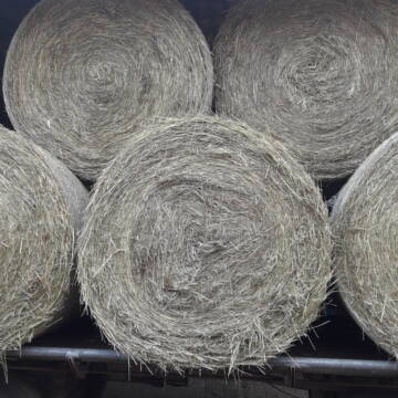
HD-Ballen Handballen Heu Heuballen Ernte 2024
Wolfsburg
Bendlin GbR
@Bendlin_GbR
Heu
Kleinballen/HD-Ballen
Regenfrei
Käufer lädt selbst
2 weitere...
B+
Deprecated: Creation of dynamic property Zend_View_Helper_Ads::$adLink is deprecated in /var/www/stall-frei/htdocs/staging.stall-frei.de/library/Psf/View/Helper/Ads.php on line 108

Futtersack HeuToy, Fressbremse in pink
Mechtersen
STALL-FREIde Marketing
@STALL-FREI-Marketing
Stundenlange Beschäftigung die
Koliken vorbeugt, geringe Staubinhalation mit
steuerbarer Futterentnahme
Leider kein Vorschaubild
Leider kein Vorschaubild
HD-Ballen Handballen Stroh Strohballen Ernte 2024
Wolfsburg
Bendlin GbR
@Bendlin_GbR
Stroh
Kleinballen/HD-Ballen
Regenfrei
Käufer lädt selbst
2 weitere...
B+
Heu Rundballen zu verkaufen
Peine
Hof-Hoppenworth
@Hof-Hoppenworth
Heu
Empfänger lädt ab
Rundballen
Regenfrei
3 weitere...
B+

Rundballen Stroh
Elze-Esbeck
Hof Bartels
@Bartels
Stroh
Lieferant entlädt
Rundballen
Regenfrei
3 weitere...
B+


1 Palette Stramofarm Strohpellets 30Sack á 25KG
Leinefelde- Worbis
stramofarm GmbH
@stramofarm
Einstreu
Lieferant entlädt
Pellets
Regenfrei
2 weitere...
P+


1 Palette Stramofarm Heupellets 30 Sack á 15Kg
Leinefelde
stramofarm GmbH
@stramofarm
Heu
Lieferant entlädt
Pellets
Regenfrei
2 weitere...
P+

Heu in Quaderballen zu verkaufen
Bergen
Bianca Hinrichs-Schröder
@BHS1976
Futter
Empfänger lädt ab
Kleinballen/HD-Ballen
Bio
Regenfrei
2 weitere...
B+

Das Beste für die Hufe
Mechtersen
STALL-FREIde Marketing
@STALL-FREI-Marketing
Hufschmiede und Hufpfleger in Ihrer Nähe
Leider kein Vorschaubild
Leider kein Vorschaubild
Bio-Luzerneheu aus qualifiziertem Biobetrieb
Altmärkische Höhe OT Losse
Landwirtschaft H.Stoltenberg
@ReiterhofLosse
Heu
Empfänger lädt ab
Großballen
Bio
2 weitere...
B+
Leider kein Vorschaubild
Leider kein Vorschaubild
Biohafer zu verkaufen
Altmärkische Höhe OT Losse
Landwirtschaft H.Stoltenberg
@ReiterhofLosse
Futter
Empfänger lädt ab
Lose
Bio
Regenfrei
2 weitere...
B+

Luzerneheu 1.Schnitt
Teutschenthal
Nancy
@Haltergemeinschaft-TT
Heu
Empfänger lädt ab
Rundballen
Regenfrei
2 weitere...
B+
Deprecated: Creation of dynamic property Zend_View::$pageCount is deprecated in /var/www/stall-frei/htdocs/staging.stall-frei.de/library/vendor/shardj/zf1-future/library/Zend/View/Abstract.php on line 308
Deprecated: Creation of dynamic property Zend_View::$itemCountPerPage is deprecated in /var/www/stall-frei/htdocs/staging.stall-frei.de/library/vendor/shardj/zf1-future/library/Zend/View/Abstract.php on line 308
Deprecated: Creation of dynamic property Zend_View::$first is deprecated in /var/www/stall-frei/htdocs/staging.stall-frei.de/library/vendor/shardj/zf1-future/library/Zend/View/Abstract.php on line 308
Deprecated: Creation of dynamic property Zend_View::$current is deprecated in /var/www/stall-frei/htdocs/staging.stall-frei.de/library/vendor/shardj/zf1-future/library/Zend/View/Abstract.php on line 308
Deprecated: Creation of dynamic property Zend_View::$last is deprecated in /var/www/stall-frei/htdocs/staging.stall-frei.de/library/vendor/shardj/zf1-future/library/Zend/View/Abstract.php on line 308
Deprecated: Creation of dynamic property Zend_View::$next is deprecated in /var/www/stall-frei/htdocs/staging.stall-frei.de/library/vendor/shardj/zf1-future/library/Zend/View/Abstract.php on line 308
Deprecated: Creation of dynamic property Zend_View::$pagesInRange is deprecated in /var/www/stall-frei/htdocs/staging.stall-frei.de/library/vendor/shardj/zf1-future/library/Zend/View/Abstract.php on line 308
Deprecated: Creation of dynamic property Zend_View::$firstPageInRange is deprecated in /var/www/stall-frei/htdocs/staging.stall-frei.de/library/vendor/shardj/zf1-future/library/Zend/View/Abstract.php on line 308
Deprecated: Creation of dynamic property Zend_View::$lastPageInRange is deprecated in /var/www/stall-frei/htdocs/staging.stall-frei.de/library/vendor/shardj/zf1-future/library/Zend/View/Abstract.php on line 308
Deprecated: Creation of dynamic property Zend_View::$currentItemCount is deprecated in /var/www/stall-frei/htdocs/staging.stall-frei.de/library/vendor/shardj/zf1-future/library/Zend/View/Abstract.php on line 308
Deprecated: Creation of dynamic property Zend_View::$totalItemCount is deprecated in /var/www/stall-frei/htdocs/staging.stall-frei.de/library/vendor/shardj/zf1-future/library/Zend/View/Abstract.php on line 308
Deprecated: Creation of dynamic property Zend_View::$firstItemNumber is deprecated in /var/www/stall-frei/htdocs/staging.stall-frei.de/library/vendor/shardj/zf1-future/library/Zend/View/Abstract.php on line 308
Deprecated: Creation of dynamic property Zend_View::$lastItemNumber is deprecated in /var/www/stall-frei/htdocs/staging.stall-frei.de/library/vendor/shardj/zf1-future/library/Zend/View/Abstract.php on line 308
Deprecated: Creation of dynamic property Zend_View::$router is deprecated in /var/www/stall-frei/htdocs/staging.stall-frei.de/library/vendor/shardj/zf1-future/library/Zend/View/Abstract.php on line 308
Deprecated: Creation of dynamic property Zend_View::$urlParams is deprecated in /var/www/stall-frei/htdocs/staging.stall-frei.de/library/vendor/shardj/zf1-future/library/Zend/View/Abstract.php on line 308
Deprecated: Creation of dynamic property Zend_View::$showAds is deprecated in /var/www/stall-frei/htdocs/staging.stall-frei.de/library/vendor/shardj/zf1-future/library/Zend/View/Abstract.php on line 308
Deprecated: Creation of dynamic property Zend_View::$objectIds is deprecated in /var/www/stall-frei/htdocs/staging.stall-frei.de/library/vendor/shardj/zf1-future/library/Zend/View/Abstract.php on line 308
Deprecated: Creation of dynamic property Zend_View::$showNavbar is deprecated in /var/www/stall-frei/htdocs/staging.stall-frei.de/library/vendor/shardj/zf1-future/library/Zend/View/Abstract.php on line 308
Deprecated: Creation of dynamic property Zend_View::$showBreadcrumb is deprecated in /var/www/stall-frei/htdocs/staging.stall-frei.de/library/vendor/shardj/zf1-future/library/Zend/View/Abstract.php on line 308
Deprecated: Creation of dynamic property Zend_View::$showFooter is deprecated in /var/www/stall-frei/htdocs/staging.stall-frei.de/library/vendor/shardj/zf1-future/library/Zend/View/Abstract.php on line 308
Deprecated: Creation of dynamic property Zend_View::$showInternalAds is deprecated in /var/www/stall-frei/htdocs/staging.stall-frei.de/library/vendor/shardj/zf1-future/library/Zend/View/Abstract.php on line 308
Deprecated: Creation of dynamic property Zend_View::$blNoContent is deprecated in /var/www/stall-frei/htdocs/staging.stall-frei.de/library/vendor/shardj/zf1-future/library/Zend/View/Abstract.php on line 308
Deprecated: Creation of dynamic property Zend_View::$sMetaDesc is deprecated in /var/www/stall-frei/htdocs/staging.stall-frei.de/library/vendor/shardj/zf1-future/library/Zend/View/Abstract.php on line 308
Deprecated: Creation of dynamic property Zend_View::$useGmaps is deprecated in /var/www/stall-frei/htdocs/staging.stall-frei.de/library/vendor/shardj/zf1-future/library/Zend/View/Abstract.php on line 308
Deprecated: Creation of dynamic property Zend_View::$touches is deprecated in /var/www/stall-frei/htdocs/staging.stall-frei.de/library/vendor/shardj/zf1-future/library/Zend/View/Abstract.php on line 308
Deprecated: Creation of dynamic property Zend_View::$oProject is deprecated in /var/www/stall-frei/htdocs/staging.stall-frei.de/library/vendor/shardj/zf1-future/library/Zend/View/Abstract.php on line 308
Deprecated: Creation of dynamic property Zend_View::$pageHeadline is deprecated in /var/www/stall-frei/htdocs/staging.stall-frei.de/library/vendor/shardj/zf1-future/library/Zend/View/Abstract.php on line 308
Deprecated: Creation of dynamic property Zend_View::$disableLocationField is deprecated in /var/www/stall-frei/htdocs/staging.stall-frei.de/library/vendor/shardj/zf1-future/library/Zend/View/Abstract.php on line 308
Deprecated: Creation of dynamic property Zend_View::$isSearch is deprecated in /var/www/stall-frei/htdocs/staging.stall-frei.de/library/vendor/shardj/zf1-future/library/Zend/View/Abstract.php on line 308
Deprecated: Creation of dynamic property Zend_View::$pageTitle is deprecated in /var/www/stall-frei/htdocs/staging.stall-frei.de/library/vendor/shardj/zf1-future/library/Zend/View/Abstract.php on line 308
Deprecated: Creation of dynamic property Psf_Form_Element_Text::$class is deprecated in /var/www/stall-frei/htdocs/staging.stall-frei.de/library/vendor/shardj/zf1-future/library/Zend/Form/Element.php on line 874
Deprecated: Creation of dynamic property Psf_Form_Element_Text::$size is deprecated in /var/www/stall-frei/htdocs/staging.stall-frei.de/library/vendor/shardj/zf1-future/library/Zend/Form/Element.php on line 874
Deprecated: Creation of dynamic property Psf_Form_Element_Text::$placeholder is deprecated in /var/www/stall-frei/htdocs/staging.stall-frei.de/library/vendor/shardj/zf1-future/library/Zend/Form/Element.php on line 874
Deprecated: Creation of dynamic property Psf_Form_Element_Hidden::$class is deprecated in /var/www/stall-frei/htdocs/staging.stall-frei.de/library/vendor/shardj/zf1-future/library/Zend/Form/Element.php on line 874
Deprecated: Creation of dynamic property Psf_Form_Element_Hidden::$class is deprecated in /var/www/stall-frei/htdocs/staging.stall-frei.de/library/vendor/shardj/zf1-future/library/Zend/Form/Element.php on line 874
Deprecated: Creation of dynamic property Psf_Form_Element_Hidden::$class is deprecated in /var/www/stall-frei/htdocs/staging.stall-frei.de/library/vendor/shardj/zf1-future/library/Zend/Form/Element.php on line 874
Deprecated: Creation of dynamic property Psf_Form_Element_Hidden::$class is deprecated in /var/www/stall-frei/htdocs/staging.stall-frei.de/library/vendor/shardj/zf1-future/library/Zend/Form/Element.php on line 874
Deprecated: Creation of dynamic property Psf_Form_Element_Select::$class is deprecated in /var/www/stall-frei/htdocs/staging.stall-frei.de/library/vendor/shardj/zf1-future/library/Zend/Form/Element.php on line 874
Deprecated: Creation of dynamic property Psf_Form_Element_Select::$class is deprecated in /var/www/stall-frei/htdocs/staging.stall-frei.de/library/vendor/shardj/zf1-future/library/Zend/Form/Element.php on line 874
Deprecated: Creation of dynamic property Psf_Form_Element_Select::$class is deprecated in /var/www/stall-frei/htdocs/staging.stall-frei.de/library/vendor/shardj/zf1-future/library/Zend/Form/Element.php on line 874
Deprecated: Creation of dynamic property Psf_Form_Element_Select::$class is deprecated in /var/www/stall-frei/htdocs/staging.stall-frei.de/library/vendor/shardj/zf1-future/library/Zend/Form/Element.php on line 874
Deprecated: Creation of dynamic property Zend_View::$sort is deprecated in /var/www/stall-frei/htdocs/staging.stall-frei.de/library/vendor/shardj/zf1-future/library/Zend/View/Abstract.php on line 308
Deprecated: Creation of dynamic property Zend_View::$searchLocation is deprecated in /var/www/stall-frei/htdocs/staging.stall-frei.de/library/vendor/shardj/zf1-future/library/Zend/View/Abstract.php on line 308
Deprecated: Creation of dynamic property Zend_View::$locationHint is deprecated in /var/www/stall-frei/htdocs/staging.stall-frei.de/library/vendor/shardj/zf1-future/library/Zend/View/Abstract.php on line 308
Psf_GeoCoder_Abstract::getLocation: Elm Get Location CachedOrLive
Psf_GeoCoder_Abstract::getCachedOrLive: Elm
Psf_GeoCoder_OpenCageData::makeApiRequest: response:
Array
(
[documentation] => https://opencagedata.com/api
[licenses] => Array
(
[0] => Array
(
[name] => see attribution guide
[url] => https://opencagedata.com/credits
)
)
[results] => Array
(
[0] => Array
(
[bounds] => Array
(
[northeast] => Array
(
[lat] => 52.2529725
[lng] => 10.952411
)
[southwest] => Array
(
[lat] => 52.1345164
[lng] => 10.7028344
)
)
[components] => Array
(
[ISO_3166-1_alpha-2] => DE
[ISO_3166-1_alpha-3] => DEU
[ISO_3166-2] => Array
(
[0] => DE-NI
)
[_category] => natural/water
[_type] => forest
[continent] => Europe
[country] => Deutschland
[country_code] => de
[county] => Landkreis Helmstedt
[forest] => Elm
[political_union] => European Union
[state] => Niedersachsen
[state_code] => NI
)
[confidence] => 5
[formatted] => Elm, Helmstedt, Niedersachsen, Deutschland
[geometry] => Array
(
[lat] => 52.1615728
[lng] => 10.8948364
)
)
[1] => Array
(
[bounds] => Array
(
[northeast] => Array
(
[lat] => 53.6097315
[lng] => 8.7798704
)
[southwest] => Array
(
[lat] => 53.551921
[lng] => 8.7009226
)
)
[components] => Array
(
[ISO_3166-1_alpha-2] => DE
[ISO_3166-1_alpha-3] => DEU
[ISO_3166-2] => Array
(
[0] => DE-NI
)
[_category] => place
[_normalized_city] => Geestland
[_type] => neighbourhood
[continent] => Europe
[country] => Deutschland
[country_code] => de
[county] => Landkreis Cuxhaven
[political_union] => European Union
[state] => Niedersachsen
[state_code] => NI
[suburb] => Elmlohe
[town] => Geestland
)
[confidence] => 7
[formatted] => Elmlohe, Geestland, Niedersachsen, Deutschland
[geometry] => Array
(
[lat] => 53.5848515
[lng] => 8.7442822
)
)
[2] => Array
(
[bounds] => Array
(
[northeast] => Array
(
[lat] => 50.387143
[lng] => 9.6093877
)
[southwest] => Array
(
[lat] => 50.3483712
[lng] => 9.5323732
)
)
[components] => Array
(
[ISO_3166-1_alpha-2] => DE
[ISO_3166-1_alpha-3] => DEU
[ISO_3166-2] => Array
(
[0] => DE-HE
)
[_category] => place
[_normalized_city] => Elm
[_type] => village
[continent] => Europe
[country] => Deutschland
[country_code] => de
[county] => Main-Kinzig-Kreis
[municipality] => Schlüchtern
[political_union] => European Union
[postcode] => 36381
[state] => Hessen
[state_code] => HE
[village] => Elm
)
[confidence] => 7
[formatted] => 36381 Elm, Deutschland
[geometry] => Array
(
[lat] => 50.3611612
[lng] => 9.5582959
)
)
[3] => Array
(
[bounds] => Array
(
[northeast] => Array
(
[lat] => 53.5359135
[lng] => 9.2247887
)
[southwest] => Array
(
[lat] => 53.4959135
[lng] => 9.1847887
)
)
[components] => Array
(
[ISO_3166-1_alpha-2] => DE
[ISO_3166-1_alpha-3] => DEU
[ISO_3166-2] => Array
(
[0] => DE-NI
)
[_category] => place
[_normalized_city] => Bremervörde
[_type] => village
[continent] => Europe
[country] => Deutschland
[country_code] => de
[county] => Landkreis Rotenburg (Wümme)
[political_union] => European Union
[state] => Niedersachsen
[state_code] => NI
[town] => Bremervörde
[village] => Elm
)
[confidence] => 7
[formatted] => Elm, Niedersachsen, Deutschland
[geometry] => Array
(
[lat] => 53.5159135
[lng] => 9.2047887
)
)
[4] => Array
(
[bounds] => Array
(
[northeast] => Array
(
[lat] => 49.3267517
[lng] => 6.8828437
)
[southwest] => Array
(
[lat] => 49.2820268
[lng] => 6.8184563
)
)
[components] => Array
(
[ISO_3166-1_alpha-2] => DE
[ISO_3166-1_alpha-3] => DEU
[ISO_3166-2] => Array
(
[0] => DE-SL
)
[_category] => place
[_normalized_city] => Schwalbach
[_type] => village
[city] => Schwalbach
[continent] => Europe
[country] => Deutschland
[country_code] => de
[county] => Landkreis Saarlouis
[political_union] => European Union
[state] => Saarland
[state_code] => SL
[village] => Elm
)
[confidence] => 7
[formatted] => Elm, Saarland, Deutschland
[geometry] => Array
(
[lat] => 49.2982633
[lng] => 6.8437558
)
)
[5] => Array
(
[bounds] => Array
(
[northeast] => Array
(
[lat] => 53.547359
[lng] => 9.2830491
)
[southwest] => Array
(
[lat] => 53.495507
[lng] => 9.174926
)
)
[components] => Array
(
[ISO_3166-1_alpha-2] => DE
[ISO_3166-1_alpha-3] => DEU
[ISO_3166-2] => Array
(
[0] => DE-NI
)
[_category] => place
[_normalized_city] => Bremervörde
[_type] => neighbourhood
[city_district] => Elm
[continent] => Europe
[country] => Deutschland
[country_code] => de
[county] => Landkreis Rotenburg (Wümme)
[political_union] => European Union
[state] => Niedersachsen
[state_code] => NI
[town] => Bremervörde
)
[confidence] => 7
[formatted] => Elm, Bremervörde, Niedersachsen, Deutschland
[geometry] => Array
(
[lat] => 53.5212975
[lng] => 9.2337998
)
)
[6] => Array
(
[bounds] => Array
(
[northeast] => Array
(
[lat] => 50.5435322
[lng] => 11.9881049
)
[southwest] => Array
(
[lat] => 50.5434322
[lng] => 11.9880049
)
)
[components] => Array
(
[ISO_3166-1_alpha-2] => DE
[ISO_3166-1_alpha-3] => DEU
[ISO_3166-2] => Array
(
[0] => DE-SN
)
[_category] => natural/water
[_normalized_city] => Rosenbach/Vogtland
[_type] => peak
[continent] => Europe
[country] => Deutschland
[country_code] => de
[county] => Vogtlandkreis
[municipality] => Rosenbach/Vogtland
[peak] => Elm
[political_union] => European Union
[postcode] => 08539
[state] => Sachsen
[state_code] => SN
)
[confidence] => 9
[formatted] => Elm, 08539 Rosenbach/Vogtland, Deutschland
[geometry] => Array
(
[lat] => 50.5434822
[lng] => 11.9880549
)
)
[7] => Array
(
[bounds] => Array
(
[northeast] => Array
(
[lat] => 47.7754138
[lng] => 11.8609692
)
[southwest] => Array
(
[lat] => 47.7753138
[lng] => 11.8608692
)
)
[components] => Array
(
[ISO_3166-1_alpha-2] => DE
[ISO_3166-1_alpha-3] => DEU
[ISO_3166-2] => Array
(
[0] => DE-BY
)
[_category] => building
[_normalized_city] => Miesbach
[_type] => building
[continent] => Europe
[country] => Deutschland
[country_code] => de
[county] => Landkreis Miesbach
[isolated_dwelling] => Elm
[political_union] => European Union
[postcode] => 83714
[state] => Bayern
[state_code] => BY
[town] => Miesbach
)
[confidence] => 10
[formatted] => Elm, 83714 Miesbach, Deutschland
[geometry] => Array
(
[lat] => 47.7753638
[lng] => 11.8609192
)
)
[8] => Array
(
[components] => Array
(
[ISO_3166-1_alpha-2] => FR
[ISO_3166-1_alpha-3] => FRA
[ISO_3166-2] => Array
(
[0] => FR-GES
[1] => FR-6AE
[2] => FR-68
)
[_category] => road
[_normalized_city] => Munster
[_type] => road
[city] => Munster
[continent] => Europe
[country] => France
[country_code] => fr
[county] => Haut-Rhin
[local_authority] => Communauté de communes de la Vallée de Munster
[political_union] => European Union
[postcode] => 68140
[road] => Rue de l’Elm
[state] => Grand Est
[state_code] => GES
)
[confidence] => 2
[formatted] => Rue de l’Elm, 68140 Munster, France
[geometry] => Array
(
[lat] => 48.039063
[lng] => 7.140301
)
)
[9] => Array
(
[components] => Array
(
[ISO_3166-1_alpha-2] => FR
[ISO_3166-1_alpha-3] => FRA
[ISO_3166-2] => Array
(
[0] => FR-OCC
[1] => FR-66
)
[_category] => road
[_normalized_city] => Collioure
[_type] => road
[city] => Collioure
[continent] => Europe
[country] => France
[country_code] => fr
[county] => Pyrénées-Orientales
[local_authority] => Communauté de communes des Albères, de la Côte Vermeille et de l'Illibéris
[political_union] => European Union
[postcode] => 66190
[road] => Chemin de Saint Elme
[state] => Occitanie
[state_code] => OCC
)
[confidence] => 2
[formatted] => Chemin de Saint Elme, 66190 Collioure, France
[geometry] => Array
(
[lat] => 42.521294
[lng] => 3.088056
)
)
)
[status] => Array
(
[code] => 200
[message] => OK
)
[stay_informed] => Array
(
[blog] => https://blog.opencagedata.com
[mastodon] => https://en.osm.town/@opencage
)
[thanks] => For using an OpenCage API
[timestamp] => Array
(
[created_http] => Sun, 08 Feb 2026 14:48:44 GMT
[created_unix] => 1770562124
)
[total_results] => 10
)
Psf_GeoCoder_Abstract::convertLocationResult
{"documentation":"https:\/\/opencagedata.com\/api","licenses":[{"name":"see attribution guide","url":"https:\/\/opencagedata.com\/credits"}],"results":[{"bounds":{"northeast":{"lat":52.2529725,"lng":10.952411},"southwest":{"lat":52.1345164,"lng":10.7028344}},"components":{"ISO_3166-1_alpha-2":"DE","ISO_3166-1_alpha-3":"DEU","ISO_3166-2":["DE-NI"],"_category":"natural\/water","_type":"forest","continent":"Europe","country":"Deutschland","country_code":"de","county":"Landkreis Helmstedt","forest":"Elm","political_union":"European Union","state":"Niedersachsen","state_code":"NI"},"confidence":5,"formatted":"Elm, Helmstedt, Niedersachsen, Deutschland","geometry":{"lat":52.1615728,"lng":10.8948364}},{"bounds":{"northeast":{"lat":53.6097315,"lng":8.7798704},"southwest":{"lat":53.551921,"lng":8.7009226}},"components":{"ISO_3166-1_alpha-2":"DE","ISO_3166-1_alpha-3":"DEU","ISO_3166-2":["DE-NI"],"_category":"place","_normalized_city":"Geestland","_type":"neighbourhood","continent":"Europe","country":"Deutschland","country_code":"de","county":"Landkreis Cuxhaven","political_union":"European Union","state":"Niedersachsen","state_code":"NI","suburb":"Elmlohe","town":"Geestland"},"confidence":7,"formatted":"Elmlohe, Geestland, Niedersachsen, Deutschland","geometry":{"lat":53.5848515,"lng":8.7442822}},{"bounds":{"northeast":{"lat":50.387143,"lng":9.6093877},"southwest":{"lat":50.3483712,"lng":9.5323732}},"components":{"ISO_3166-1_alpha-2":"DE","ISO_3166-1_alpha-3":"DEU","ISO_3166-2":["DE-HE"],"_category":"place","_normalized_city":"Elm","_type":"village","continent":"Europe","country":"Deutschland","country_code":"de","county":"Main-Kinzig-Kreis","municipality":"Schl\u00fcchtern","political_union":"European Union","postcode":"36381","state":"Hessen","state_code":"HE","village":"Elm"},"confidence":7,"formatted":"36381 Elm, Deutschland","geometry":{"lat":50.3611612,"lng":9.5582959}},{"bounds":{"northeast":{"lat":53.5359135,"lng":9.2247887},"southwest":{"lat":53.4959135,"lng":9.1847887}},"components":{"ISO_3166-1_alpha-2":"DE","ISO_3166-1_alpha-3":"DEU","ISO_3166-2":["DE-NI"],"_category":"place","_normalized_city":"Bremerv\u00f6rde","_type":"village","continent":"Europe","country":"Deutschland","country_code":"de","county":"Landkreis Rotenburg (W\u00fcmme)","political_union":"European Union","state":"Niedersachsen","state_code":"NI","town":"Bremerv\u00f6rde","village":"Elm"},"confidence":7,"formatted":"Elm, Niedersachsen, Deutschland","geometry":{"lat":53.5159135,"lng":9.2047887}},{"bounds":{"northeast":{"lat":49.3267517,"lng":6.8828437},"southwest":{"lat":49.2820268,"lng":6.8184563}},"components":{"ISO_3166-1_alpha-2":"DE","ISO_3166-1_alpha-3":"DEU","ISO_3166-2":["DE-SL"],"_category":"place","_normalized_city":"Schwalbach","_type":"village","city":"Schwalbach","continent":"Europe","country":"Deutschland","country_code":"de","county":"Landkreis Saarlouis","political_union":"European Union","state":"Saarland","state_code":"SL","village":"Elm"},"confidence":7,"formatted":"Elm, Saarland, Deutschland","geometry":{"lat":49.2982633,"lng":6.8437558}},{"bounds":{"northeast":{"lat":53.547359,"lng":9.2830491},"southwest":{"lat":53.495507,"lng":9.174926}},"components":{"ISO_3166-1_alpha-2":"DE","ISO_3166-1_alpha-3":"DEU","ISO_3166-2":["DE-NI"],"_category":"place","_normalized_city":"Bremerv\u00f6rde","_type":"neighbourhood","city_district":"Elm","continent":"Europe","country":"Deutschland","country_code":"de","county":"Landkreis Rotenburg (W\u00fcmme)","political_union":"European Union","state":"Niedersachsen","state_code":"NI","town":"Bremerv\u00f6rde"},"confidence":7,"formatted":"Elm, Bremerv\u00f6rde, Niedersachsen, Deutschland","geometry":{"lat":53.5212975,"lng":9.2337998}},{"bounds":{"northeast":{"lat":50.5435322,"lng":11.9881049},"southwest":{"lat":50.5434322,"lng":11.9880049}},"components":{"ISO_3166-1_alpha-2":"DE","ISO_3166-1_alpha-3":"DEU","ISO_3166-2":["DE-SN"],"_category":"natural\/water","_normalized_city":"Rosenbach\/Vogtland","_type":"peak","continent":"Europe","country":"Deutschland","country_code":"de","county":"Vogtlandkreis","municipality":"Rosenbach\/Vogtland","peak":"Elm","political_union":"European Union","postcode":"08539","state":"Sachsen","state_code":"SN"},"confidence":9,"formatted":"Elm, 08539 Rosenbach\/Vogtland, Deutschland","geometry":{"lat":50.5434822,"lng":11.9880549}},{"bounds":{"northeast":{"lat":47.7754138,"lng":11.8609692},"southwest":{"lat":47.7753138,"lng":11.8608692}},"components":{"ISO_3166-1_alpha-2":"DE","ISO_3166-1_alpha-3":"DEU","ISO_3166-2":["DE-BY"],"_category":"building","_normalized_city":"Miesbach","_type":"building","continent":"Europe","country":"Deutschland","country_code":"de","county":"Landkreis Miesbach","isolated_dwelling":"Elm","political_union":"European Union","postcode":"83714","state":"Bayern","state_code":"BY","town":"Miesbach"},"confidence":10,"formatted":"Elm, 83714 Miesbach, Deutschland","geometry":{"lat":47.7753638,"lng":11.8609192}},{"components":{"ISO_3166-1_alpha-2":"FR","ISO_3166-1_alpha-3":"FRA","ISO_3166-2":["FR-GES","FR-6AE","FR-68"],"_category":"road","_normalized_city":"Munster","_type":"road","city":"Munster","continent":"Europe","country":"France","country_code":"fr","county":"Haut-Rhin","local_authority":"Communaut\u00e9 de communes de la Vall\u00e9e de Munster","political_union":"European Union","postcode":"68140","road":"Rue de l\u2019Elm","state":"Grand Est","state_code":"GES"},"confidence":2,"formatted":"Rue de l\u2019Elm, 68140 Munster, France","geometry":{"lat":48.039063,"lng":7.140301}},{"components":{"ISO_3166-1_alpha-2":"FR","ISO_3166-1_alpha-3":"FRA","ISO_3166-2":["FR-OCC","FR-66"],"_category":"road","_normalized_city":"Collioure","_type":"road","city":"Collioure","continent":"Europe","country":"France","country_code":"fr","county":"Pyr\u00e9n\u00e9es-Orientales","local_authority":"Communaut\u00e9 de communes des Alb\u00e8res, de la C\u00f4te Vermeille et de l'Illib\u00e9ris","political_union":"European Union","postcode":"66190","road":"Chemin de Saint Elme","state":"Occitanie","state_code":"OCC"},"confidence":2,"formatted":"Chemin de Saint Elme, 66190 Collioure, France","geometry":{"lat":42.521294,"lng":3.088056}}],"status":{"code":200,"message":"OK"},"stay_informed":{"blog":"https:\/\/blog.opencagedata.com","mastodon":"https:\/\/en.osm.town\/@opencage"},"thanks":"For using an OpenCage API","timestamp":{"created_http":"Sun, 08 Feb 2026 14:48:44 GMT","created_unix":1770562124},"total_results":10}Array
(
[0] => stdClass Object
(
[bounds] => stdClass Object
(
[northeast] => stdClass Object
(
[lat] => 52.2529725
[lng] => 10.952411
)
[southwest] => stdClass Object
(
[lat] => 52.1345164
[lng] => 10.7028344
)
)
[components] => stdClass Object
(
[ISO_3166-1_alpha-2] => DE
[ISO_3166-1_alpha-3] => DEU
[ISO_3166-2] => Array
(
[0] => DE-NI
)
[_category] => natural/water
[_type] => forest
[continent] => Europe
[country] => Deutschland
[country_code] => de
[county] => Landkreis Helmstedt
[forest] => Elm
[political_union] => European Union
[state] => Niedersachsen
[state_code] => NI
)
[confidence] => 5
[formatted] => Elm, Helmstedt, Niedersachsen, Deutschland
[geometry] => stdClass Object
(
[lat] => 52.1615728
[lng] => 10.8948364
)
)
[1] => stdClass Object
(
[bounds] => stdClass Object
(
[northeast] => stdClass Object
(
[lat] => 53.6097315
[lng] => 8.7798704
)
[southwest] => stdClass Object
(
[lat] => 53.551921
[lng] => 8.7009226
)
)
[components] => stdClass Object
(
[ISO_3166-1_alpha-2] => DE
[ISO_3166-1_alpha-3] => DEU
[ISO_3166-2] => Array
(
[0] => DE-NI
)
[_category] => place
[_normalized_city] => Geestland
[_type] => neighbourhood
[continent] => Europe
[country] => Deutschland
[country_code] => de
[county] => Landkreis Cuxhaven
[political_union] => European Union
[state] => Niedersachsen
[state_code] => NI
[suburb] => Elmlohe
[town] => Geestland
)
[confidence] => 7
[formatted] => Elmlohe, Geestland, Niedersachsen, Deutschland
[geometry] => stdClass Object
(
[lat] => 53.5848515
[lng] => 8.7442822
)
)
[2] => stdClass Object
(
[bounds] => stdClass Object
(
[northeast] => stdClass Object
(
[lat] => 50.387143
[lng] => 9.6093877
)
[southwest] => stdClass Object
(
[lat] => 50.3483712
[lng] => 9.5323732
)
)
[components] => stdClass Object
(
[ISO_3166-1_alpha-2] => DE
[ISO_3166-1_alpha-3] => DEU
[ISO_3166-2] => Array
(
[0] => DE-HE
)
[_category] => place
[_normalized_city] => Elm
[_type] => village
[continent] => Europe
[country] => Deutschland
[country_code] => de
[county] => Main-Kinzig-Kreis
[municipality] => Schlüchtern
[political_union] => European Union
[postcode] => 36381
[state] => Hessen
[state_code] => HE
[village] => Elm
)
[confidence] => 7
[formatted] => 36381 Elm, Deutschland
[geometry] => stdClass Object
(
[lat] => 50.3611612
[lng] => 9.5582959
)
)
[3] => stdClass Object
(
[bounds] => stdClass Object
(
[northeast] => stdClass Object
(
[lat] => 53.5359135
[lng] => 9.2247887
)
[southwest] => stdClass Object
(
[lat] => 53.4959135
[lng] => 9.1847887
)
)
[components] => stdClass Object
(
[ISO_3166-1_alpha-2] => DE
[ISO_3166-1_alpha-3] => DEU
[ISO_3166-2] => Array
(
[0] => DE-NI
)
[_category] => place
[_normalized_city] => Bremervörde
[_type] => village
[continent] => Europe
[country] => Deutschland
[country_code] => de
[county] => Landkreis Rotenburg (Wümme)
[political_union] => European Union
[state] => Niedersachsen
[state_code] => NI
[town] => Bremervörde
[village] => Elm
)
[confidence] => 7
[formatted] => Elm, Niedersachsen, Deutschland
[geometry] => stdClass Object
(
[lat] => 53.5159135
[lng] => 9.2047887
)
)
[4] => stdClass Object
(
[bounds] => stdClass Object
(
[northeast] => stdClass Object
(
[lat] => 49.3267517
[lng] => 6.8828437
)
[southwest] => stdClass Object
(
[lat] => 49.2820268
[lng] => 6.8184563
)
)
[components] => stdClass Object
(
[ISO_3166-1_alpha-2] => DE
[ISO_3166-1_alpha-3] => DEU
[ISO_3166-2] => Array
(
[0] => DE-SL
)
[_category] => place
[_normalized_city] => Schwalbach
[_type] => village
[city] => Schwalbach
[continent] => Europe
[country] => Deutschland
[country_code] => de
[county] => Landkreis Saarlouis
[political_union] => European Union
[state] => Saarland
[state_code] => SL
[village] => Elm
)
[confidence] => 7
[formatted] => Elm, Saarland, Deutschland
[geometry] => stdClass Object
(
[lat] => 49.2982633
[lng] => 6.8437558
)
)
[5] => stdClass Object
(
[bounds] => stdClass Object
(
[northeast] => stdClass Object
(
[lat] => 53.547359
[lng] => 9.2830491
)
[southwest] => stdClass Object
(
[lat] => 53.495507
[lng] => 9.174926
)
)
[components] => stdClass Object
(
[ISO_3166-1_alpha-2] => DE
[ISO_3166-1_alpha-3] => DEU
[ISO_3166-2] => Array
(
[0] => DE-NI
)
[_category] => place
[_normalized_city] => Bremervörde
[_type] => neighbourhood
[city_district] => Elm
[continent] => Europe
[country] => Deutschland
[country_code] => de
[county] => Landkreis Rotenburg (Wümme)
[political_union] => European Union
[state] => Niedersachsen
[state_code] => NI
[town] => Bremervörde
)
[confidence] => 7
[formatted] => Elm, Bremervörde, Niedersachsen, Deutschland
[geometry] => stdClass Object
(
[lat] => 53.5212975
[lng] => 9.2337998
)
)
[6] => stdClass Object
(
[bounds] => stdClass Object
(
[northeast] => stdClass Object
(
[lat] => 50.5435322
[lng] => 11.9881049
)
[southwest] => stdClass Object
(
[lat] => 50.5434322
[lng] => 11.9880049
)
)
[components] => stdClass Object
(
[ISO_3166-1_alpha-2] => DE
[ISO_3166-1_alpha-3] => DEU
[ISO_3166-2] => Array
(
[0] => DE-SN
)
[_category] => natural/water
[_normalized_city] => Rosenbach/Vogtland
[_type] => peak
[continent] => Europe
[country] => Deutschland
[country_code] => de
[county] => Vogtlandkreis
[municipality] => Rosenbach/Vogtland
[peak] => Elm
[political_union] => European Union
[postcode] => 08539
[state] => Sachsen
[state_code] => SN
)
[confidence] => 9
[formatted] => Elm, 08539 Rosenbach/Vogtland, Deutschland
[geometry] => stdClass Object
(
[lat] => 50.5434822
[lng] => 11.9880549
)
)
[7] => stdClass Object
(
[bounds] => stdClass Object
(
[northeast] => stdClass Object
(
[lat] => 47.7754138
[lng] => 11.8609692
)
[southwest] => stdClass Object
(
[lat] => 47.7753138
[lng] => 11.8608692
)
)
[components] => stdClass Object
(
[ISO_3166-1_alpha-2] => DE
[ISO_3166-1_alpha-3] => DEU
[ISO_3166-2] => Array
(
[0] => DE-BY
)
[_category] => building
[_normalized_city] => Miesbach
[_type] => building
[continent] => Europe
[country] => Deutschland
[country_code] => de
[county] => Landkreis Miesbach
[isolated_dwelling] => Elm
[political_union] => European Union
[postcode] => 83714
[state] => Bayern
[state_code] => BY
[town] => Miesbach
)
[confidence] => 10
[formatted] => Elm, 83714 Miesbach, Deutschland
[geometry] => stdClass Object
(
[lat] => 47.7753638
[lng] => 11.8609192
)
)
[8] => stdClass Object
(
[components] => stdClass Object
(
[ISO_3166-1_alpha-2] => FR
[ISO_3166-1_alpha-3] => FRA
[ISO_3166-2] => Array
(
[0] => FR-GES
[1] => FR-6AE
[2] => FR-68
)
[_category] => road
[_normalized_city] => Munster
[_type] => road
[city] => Munster
[continent] => Europe
[country] => France
[country_code] => fr
[county] => Haut-Rhin
[local_authority] => Communauté de communes de la Vallée de Munster
[political_union] => European Union
[postcode] => 68140
[road] => Rue de l’Elm
[state] => Grand Est
[state_code] => GES
)
[confidence] => 2
[formatted] => Rue de l’Elm, 68140 Munster, France
[geometry] => stdClass Object
(
[lat] => 48.039063
[lng] => 7.140301
)
)
[9] => stdClass Object
(
[components] => stdClass Object
(
[ISO_3166-1_alpha-2] => FR
[ISO_3166-1_alpha-3] => FRA
[ISO_3166-2] => Array
(
[0] => FR-OCC
[1] => FR-66
)
[_category] => road
[_normalized_city] => Collioure
[_type] => road
[city] => Collioure
[continent] => Europe
[country] => France
[country_code] => fr
[county] => Pyrénées-Orientales
[local_authority] => Communauté de communes des Albères, de la Côte Vermeille et de l'Illibéris
[political_union] => European Union
[postcode] => 66190
[road] => Chemin de Saint Elme
[state] => Occitanie
[state_code] => OCC
)
[confidence] => 2
[formatted] => Chemin de Saint Elme, 66190 Collioure, France
[geometry] => stdClass Object
(
[lat] => 42.521294
[lng] => 3.088056
)
)
)
Psf_GeoCoder_OpenCageData::getKeyMap: 0
stdClass Object
(
    [bounds] => stdClass Object
        (
            [northeast] => stdClass Object
                (
                    [lat] => 52.2529725
                    [lng] => 10.952411
                )

            [southwest] => stdClass Object
                (
                    [lat] => 52.1345164
                    [lng] => 10.7028344
                )

        )

    [components] => stdClass Object
        (
            [ISO_3166-1_alpha-2] => DE
            [ISO_3166-1_alpha-3] => DEU
            [ISO_3166-2] => Array
                (
                    [0] => DE-NI
                )

            [_category] => natural/water
            [_type] => forest
            [continent] => Europe
            [country] => Deutschland
            [country_code] => de
            [county] => Landkreis Helmstedt
            [forest] => Elm
            [political_union] => European Union
            [state] => Niedersachsen
            [state_code] => NI
        )

    [confidence] => 5
    [formatted] => Elm, Helmstedt, Niedersachsen, Deutschland
    [geometry] => stdClass Object
        (
            [lat] => 52.1615728
            [lng] => 10.8948364
        )

)
Psf_GeoCoder_OpenCageData::getCounty: Helmstedt
Psf_GeoCoder_OpenCageData::addMissingData REFETCH!
Array
(
    [address] => Elm, Helmstedt, Niedersachsen, Deutschland
    [type] => forest
    [street] =>
    [city] =>
    [county] => Helmstedt
    [state] => Niedersachsen
    [zip] =>
    [country] => Deutschland
    [suburb] =>
    [countrycode] => de
    [latitude] => 52.1615728
    [longitude] => 10.8948364
    [accuracy] => 1
    [confidence] => 5
    [bounds] => stdClass Object
        (
            [northeast] => stdClass Object
                (
                    [lat] => 52.2529725
                    [lng] => 10.952411
                )

            [southwest] => stdClass Object
                (
                    [lat] => 52.1345164
                    [lng] => 10.7028344
                )

        )

)
reformat!
Array
(
    [address] => Elm, Helmstedt, Niedersachsen, Deutschland
    [type] => forest
    [street] =>
    [city] =>
    [county] => Helmstedt
    [state] => Niedersachsen
    [zip] =>
    [country] => Deutschland
    [suburb] =>
    [countrycode] => de
    [latitude] => 52.1615728
    [longitude] => 10.8948364
    [accuracy] => 1
    [confidence] => 5
    [bounds] => stdClass Object
        (
            [northeast] => stdClass Object
                (
                    [lat] => 52.2529725
                    [lng] => 10.952411
                )

            [southwest] => stdClass Object
                (
                    [lat] => 52.1345164
                    [lng] => 10.7028344
                )

        )

    [place] => , Niedersachsen
    [hash] => 90072ee385ac31fd1afcb34411e0ef26
)
Psf_GeoCoder_OpenCageData::getKeyMap: 1
stdClass Object
(
    [bounds] => stdClass Object
        (
            [northeast] => stdClass Object
                (
                    [lat] => 53.6097315
                    [lng] => 8.7798704
                )

            [southwest] => stdClass Object
                (
                    [lat] => 53.551921
                    [lng] => 8.7009226
                )

        )

    [components] => stdClass Object
        (
            [ISO_3166-1_alpha-2] => DE
            [ISO_3166-1_alpha-3] => DEU
            [ISO_3166-2] => Array
                (
                    [0] => DE-NI
                )

            [_category] => place
            [_normalized_city] => Geestland
            [_type] => neighbourhood
            [continent] => Europe
            [country] => Deutschland
            [country_code] => de
            [county] => Landkreis Cuxhaven
            [political_union] => European Union
            [state] => Niedersachsen
            [state_code] => NI
            [suburb] => Elmlohe
            [town] => Geestland
        )

    [confidence] => 7
    [formatted] => Elmlohe, Geestland, Niedersachsen, Deutschland
    [geometry] => stdClass Object
        (
            [lat] => 53.5848515
            [lng] => 8.7442822
        )

)
Psf_GeoCoder_OpenCageData::getCounty: Cuxhaven
Psf_GeoCoder_OpenCageData::addMissingData REFETCH!
Array
(
    [address] => Elmlohe, Geestland, Niedersachsen, Deutschland
    [type] => neighbourhood
    [street] =>
    [city] => Geestland
    [county] => Cuxhaven
    [state] => Niedersachsen
    [zip] =>
    [country] => Deutschland
    [suburb] => Elmlohe
    [countrycode] => de
    [latitude] => 53.5848515
    [longitude] => 8.7442822
    [accuracy] => 1
    [confidence] => 7
    [bounds] => stdClass Object
        (
            [northeast] => stdClass Object
                (
                    [lat] => 53.6097315
                    [lng] => 8.7798704
                )

            [southwest] => stdClass Object
                (
                    [lat] => 53.551921
                    [lng] => 8.7009226
                )

        )

)
reformat!
Array
(
    [address] => Elmlohe, Geestland, Niedersachsen, Deutschland
    [type] => neighbourhood
    [street] =>
    [city] => Geestland
    [county] => Cuxhaven
    [state] => Niedersachsen
    [zip] =>
    [country] => Deutschland
    [suburb] => Elmlohe
    [countrycode] => de
    [latitude] => 53.5848515
    [longitude] => 8.7442822
    [accuracy] => 1
    [confidence] => 7
    [bounds] => stdClass Object
        (
            [northeast] => stdClass Object
                (
                    [lat] => 53.6097315
                    [lng] => 8.7798704
                )

            [southwest] => stdClass Object
                (
                    [lat] => 53.551921
                    [lng] => 8.7009226
                )

        )

    [place] => Geestland, Niedersachsen
    [hash] => 34e14eb2870d1aae4ebc60cb9fd04ad0
)
Psf_GeoCoder_OpenCageData::getKeyMap: 2
stdClass Object
(
    [bounds] => stdClass Object
        (
            [northeast] => stdClass Object
                (
                    [lat] => 50.387143
                    [lng] => 9.6093877
                )

            [southwest] => stdClass Object
                (
                    [lat] => 50.3483712
                    [lng] => 9.5323732
                )

        )

    [components] => stdClass Object
        (
            [ISO_3166-1_alpha-2] => DE
            [ISO_3166-1_alpha-3] => DEU
            [ISO_3166-2] => Array
                (
                    [0] => DE-HE
                )

            [_category] => place
            [_normalized_city] => Elm
            [_type] => village
            [continent] => Europe
            [country] => Deutschland
            [country_code] => de
            [county] => Main-Kinzig-Kreis
            [municipality] => Schlüchtern
            [political_union] => European Union
            [postcode] => 36381
            [state] => Hessen
            [state_code] => HE
            [village] => Elm
        )

    [confidence] => 7
    [formatted] => 36381 Elm, Deutschland
    [geometry] => stdClass Object
        (
            [lat] => 50.3611612
            [lng] => 9.5582959
        )

)
Psf_GeoCoder_OpenCageData::getCounty: Main-Kinzig-Kreis
Psf_GeoCoder_OpenCageData::addMissingData REFETCH!
Array
(
    [address] => 36381 Elm, Deutschland
    [type] => village
    [street] =>
    [city] => Elm
    [county] => Main-Kinzig-Kreis
    [state] => Hessen
    [zip] => 36381
    [country] => Deutschland
    [suburb] =>
    [countrycode] => de
    [latitude] => 50.3611612
    [longitude] => 9.5582959
    [accuracy] => 1
    [confidence] => 7
    [bounds] => stdClass Object
        (
            [northeast] => stdClass Object
                (
                    [lat] => 50.387143
                    [lng] => 9.6093877
                )

            [southwest] => stdClass Object
                (
                    [lat] => 50.3483712
                    [lng] => 9.5323732
                )

        )

)
reformat!
Array
(
    [address] => 36381 Elm, Deutschland
    [type] => village
    [street] =>
    [city] => Elm
    [county] => Main-Kinzig-Kreis
    [state] => Hessen
    [zip] => 36381
    [country] => Deutschland
    [suburb] =>
    [countrycode] => de
    [latitude] => 50.3611612
    [longitude] => 9.5582959
    [accuracy] => 1
    [confidence] => 7
    [bounds] => stdClass Object
        (
            [northeast] => stdClass Object
                (
                    [lat] => 50.387143
                    [lng] => 9.6093877
                )

            [southwest] => stdClass Object
                (
                    [lat] => 50.3483712
                    [lng] => 9.5323732
                )

        )

    [place] => 36381 Elm, Hessen
    [hash] => 44902c2e8f900777c266283da1aa5953
)
Psf_GeoCoder_OpenCageData::getKeyMap: 3
stdClass Object
(
    [bounds] => stdClass Object
        (
            [northeast] => stdClass Object
                (
                    [lat] => 53.5359135
                    [lng] => 9.2247887
                )

            [southwest] => stdClass Object
                (
                    [lat] => 53.4959135
                    [lng] => 9.1847887
                )

        )

    [components] => stdClass Object
        (
            [ISO_3166-1_alpha-2] => DE
            [ISO_3166-1_alpha-3] => DEU
            [ISO_3166-2] => Array
                (
                    [0] => DE-NI
                )

            [_category] => place
            [_normalized_city] => Bremervörde
            [_type] => village
            [continent] => Europe
            [country] => Deutschland
            [country_code] => de
            [county] => Landkreis Rotenburg (Wümme)
            [political_union] => European Union
            [state] => Niedersachsen
            [state_code] => NI
            [town] => Bremervörde
            [village] => Elm
        )

    [confidence] => 7
    [formatted] => Elm, Niedersachsen, Deutschland
    [geometry] => stdClass Object
        (
            [lat] => 53.5159135
            [lng] => 9.2047887
        )

)
Psf_GeoCoder_OpenCageData::getCounty: Rotenburg (Wümme)
Psf_GeoCoder_OpenCageData::addMissingData REFETCH!
Array
(
    [address] => Elm, Niedersachsen, Deutschland
    [type] => village
    [street] =>
    [city] => Bremervörde
    [county] => Rotenburg (Wümme)
    [state] => Niedersachsen
    [zip] =>
    [country] => Deutschland
    [suburb] =>
    [countrycode] => de
    [latitude] => 53.5159135
    [longitude] => 9.2047887
    [accuracy] => 1
    [confidence] => 7
    [bounds] => stdClass Object
        (
            [northeast] => stdClass Object
                (
                    [lat] => 53.5359135
                    [lng] => 9.2247887
                )

            [southwest] => stdClass Object
                (
                    [lat] => 53.4959135
                    [lng] => 9.1847887
                )

        )

)
reformat!
Array
(
    [address] => Bremervörde
    [type] => village
    [street] =>
    [city] => Bremervörde
    [county] => Rotenburg (Wümme)
    [state] => Niedersachsen
    [zip] =>
    [country] => Deutschland
    [suburb] =>
    [countrycode] => de
    [latitude] => 53.5159135
    [longitude] => 9.2047887
    [accuracy] => 1
    [confidence] => 7
    [bounds] => stdClass Object
        (
            [northeast] => stdClass Object
                (
                    [lat] => 53.5359135
                    [lng] => 9.2247887
                )

            [southwest] => stdClass Object
                (
                    [lat] => 53.4959135
                    [lng] => 9.1847887
                )

        )

    [place] => Bremervörde, Niedersachsen
    [hash] => 18c5f3aa2c884df02702a718caa10298
)
Psf_GeoCoder_OpenCageData::getKeyMap: 4
stdClass Object
(
    [bounds] => stdClass Object
        (
            [northeast] => stdClass Object
                (
                    [lat] => 49.3267517
                    [lng] => 6.8828437
                )

            [southwest] => stdClass Object
                (
                    [lat] => 49.2820268
                    [lng] => 6.8184563
                )

        )

    [components] => stdClass Object
        (
            [ISO_3166-1_alpha-2] => DE
            [ISO_3166-1_alpha-3] => DEU
            [ISO_3166-2] => Array
                (
                    [0] => DE-SL
                )

            [_category] => place
            [_normalized_city] => Schwalbach
            [_type] => village
            [city] => Schwalbach
            [continent] => Europe
            [country] => Deutschland
            [country_code] => de
            [county] => Landkreis Saarlouis
            [political_union] => European Union
            [state] => Saarland
            [state_code] => SL
            [village] => Elm
        )

    [confidence] => 7
    [formatted] => Elm, Saarland, Deutschland
    [geometry] => stdClass Object
        (
            [lat] => 49.2982633
            [lng] => 6.8437558
        )

)
Psf_GeoCoder_OpenCageData::getCounty: Saarlouis
Psf_GeoCoder_OpenCageData::addMissingData REFETCH!
Array
(
    [address] => Elm, Saarland, Deutschland
    [type] => village
    [street] =>
    [city] => Elm
    [county] => Saarlouis
    [state] => Saarland
    [zip] =>
    [country] => Deutschland
    [suburb] =>
    [countrycode] => de
    [latitude] => 49.2982633
    [longitude] => 6.8437558
    [accuracy] => 1
    [confidence] => 7
    [bounds] => stdClass Object
        (
            [northeast] => stdClass Object
                (
                    [lat] => 49.3267517
                    [lng] => 6.8828437
                )

            [southwest] => stdClass Object
                (
                    [lat] => 49.2820268
                    [lng] => 6.8184563
                )

        )

)
reformat!
Array
(
    [address] => Elm, Saarland, Deutschland
    [type] => village
    [street] =>
    [city] => Elm
    [county] => Saarlouis
    [state] => Saarland
    [zip] =>
    [country] => Deutschland
    [suburb] =>
    [countrycode] => de
    [latitude] => 49.2982633
    [longitude] => 6.8437558
    [accuracy] => 1
    [confidence] => 7
    [bounds] => stdClass Object
        (
            [northeast] => stdClass Object
                (
                    [lat] => 49.3267517
                    [lng] => 6.8828437
                )

            [southwest] => stdClass Object
                (
                    [lat] => 49.2820268
                    [lng] => 6.8184563
                )

        )

    [place] => Elm, Saarland
    [hash] => 2ae851f6ec6ed62cf47e8adbf4095b5e
)
Psf_GeoCoder_OpenCageData::getKeyMap: 5
stdClass Object
(
    [bounds] => stdClass Object
        (
            [northeast] => stdClass Object
                (
                    [lat] => 53.547359
                    [lng] => 9.2830491
                )

            [southwest] => stdClass Object
                (
                    [lat] => 53.495507
                    [lng] => 9.174926
                )

        )

    [components] => stdClass Object
        (
            [ISO_3166-1_alpha-2] => DE
            [ISO_3166-1_alpha-3] => DEU
            [ISO_3166-2] => Array
                (
                    [0] => DE-NI
                )

            [_category] => place
            [_normalized_city] => Bremervörde
            [_type] => neighbourhood
            [city_district] => Elm
            [continent] => Europe
            [country] => Deutschland
            [country_code] => de
            [county] => Landkreis Rotenburg (Wümme)
            [political_union] => European Union
            [state] => Niedersachsen
            [state_code] => NI
            [town] => Bremervörde
        )

    [confidence] => 7
    [formatted] => Elm, Bremervörde, Niedersachsen, Deutschland
    [geometry] => stdClass Object
        (
            [lat] => 53.5212975
            [lng] => 9.2337998
        )

)
Psf_GeoCoder_OpenCageData::getCounty: Rotenburg (Wümme)
Psf_GeoCoder_OpenCageData::addMissingData REFETCH!
Array
(
    [address] => Elm, Bremervörde, Niedersachsen, Deutschland
    [type] => neighbourhood
    [street] =>
    [city] => Bremervörde
    [county] => Rotenburg (Wümme)
    [state] => Niedersachsen
    [zip] =>
    [country] => Deutschland
    [suburb] =>
    [countrycode] => de
    [latitude] => 53.5212975
    [longitude] => 9.2337998
    [accuracy] => 1
    [confidence] => 7
    [bounds] => stdClass Object
        (
            [northeast] => stdClass Object
                (
                    [lat] => 53.547359
                    [lng] => 9.2830491
                )

            [southwest] => stdClass Object
                (
                    [lat] => 53.495507
                    [lng] => 9.174926
                )

        )

)
reformat!
Array
(
    [address] => Elm, Bremervörde, Niedersachsen, Deutschland
    [type] => neighbourhood
    [street] =>
    [city] => Bremervörde
    [county] => Rotenburg (Wümme)
    [state] => Niedersachsen
    [zip] =>
    [country] => Deutschland
    [suburb] =>
    [countrycode] => de
    [latitude] => 53.5212975
    [longitude] => 9.2337998
    [accuracy] => 1
    [confidence] => 7
    [bounds] => stdClass Object
        (
            [northeast] => stdClass Object
                (
                    [lat] => 53.547359
                    [lng] => 9.2830491
                )

            [southwest] => stdClass Object
                (
                    [lat] => 53.495507
                    [lng] => 9.174926
                )

        )

    [place] => Bremervörde, Niedersachsen
    [hash] => 18c5f3aa2c884df02702a718caa10298
)
Psf_GeoCoder_OpenCageData::getKeyMap: 6
stdClass Object
(
    [bounds] => stdClass Object
        (
            [northeast] => stdClass Object
                (
                    [lat] => 50.5435322
                    [lng] => 11.9881049
                )

            [southwest] => stdClass Object
                (
                    [lat] => 50.5434322
                    [lng] => 11.9880049
                )

        )

    [components] => stdClass Object
        (
            [ISO_3166-1_alpha-2] => DE
            [ISO_3166-1_alpha-3] => DEU
            [ISO_3166-2] => Array
                (
                    [0] => DE-SN
                )

            [_category] => natural/water
            [_normalized_city] => Rosenbach/Vogtland
            [_type] => peak
            [continent] => Europe
            [country] => Deutschland
            [country_code] => de
            [county] => Vogtlandkreis
            [municipality] => Rosenbach/Vogtland
            [peak] => Elm
            [political_union] => European Union
            [postcode] => 08539
            [state] => Sachsen
            [state_code] => SN
        )

    [confidence] => 9
    [formatted] => Elm, 08539 Rosenbach/Vogtland, Deutschland
    [geometry] => stdClass Object
        (
            [lat] => 50.5434822
            [lng] => 11.9880549
        )

)
Psf_GeoCoder_OpenCageData::getCounty: Vogtlandkreis
Psf_GeoCoder_OpenCageData::addMissingData REFETCH!
Array
(
    [address] => Elm, 08539 Rosenbach/Vogtland, Deutschland
    [type] => peak
    [street] =>
    [city] =>
    [county] => Vogtlandkreis
    [state] => Sachsen
    [zip] => 08539
    [country] => Deutschland
    [suburb] =>
    [countrycode] => de
    [latitude] => 50.5434822
    [longitude] => 11.9880549
    [accuracy] => 1
    [confidence] => 9
    [bounds] => stdClass Object
        (
            [northeast] => stdClass Object
                (
                    [lat] => 50.5435322
                    [lng] => 11.9881049
                )

            [southwest] => stdClass Object
                (
                    [lat] => 50.5434322
                    [lng] => 11.9880049
                )

        )

)
reformat!
Array
(
    [address] => Elm, 08539 Rosenbach/Vogtland, Deutschland
    [type] => peak
    [street] =>
    [city] =>
    [county] => Vogtlandkreis
    [state] => Sachsen
    [zip] => 08539
    [country] => Deutschland
    [suburb] =>
    [countrycode] => de
    [latitude] => 50.5434822
    [longitude] => 11.9880549
    [accuracy] => 1
    [confidence] => 9
    [bounds] => stdClass Object
        (
            [northeast] => stdClass Object
                (
                    [lat] => 50.5435322
                    [lng] => 11.9881049
                )

            [southwest] => stdClass Object
                (
                    [lat] => 50.5434322
                    [lng] => 11.9880049
                )

        )

    [place] => 08539 , Sachsen
    [hash] => fd0a8983220818452c9f6a40645e07e0
)
Psf_GeoCoder_OpenCageData::getKeyMap: 7
stdClass Object
(
    [bounds] => stdClass Object
        (
            [northeast] => stdClass Object
                (
                    [lat] => 47.7754138
                    [lng] => 11.8609692
                )

            [southwest] => stdClass Object
                (
                    [lat] => 47.7753138
                    [lng] => 11.8608692
                )

        )

    [components] => stdClass Object
        (
            [ISO_3166-1_alpha-2] => DE
            [ISO_3166-1_alpha-3] => DEU
            [ISO_3166-2] => Array
                (
                    [0] => DE-BY
                )

            [_category] => building
            [_normalized_city] => Miesbach
            [_type] => building
            [continent] => Europe
            [country] => Deutschland
            [country_code] => de
            [county] => Landkreis Miesbach
            [isolated_dwelling] => Elm
            [political_union] => European Union
            [postcode] => 83714
            [state] => Bayern
            [state_code] => BY
            [town] => Miesbach
        )

    [confidence] => 10
    [formatted] => Elm, 83714 Miesbach, Deutschland
    [geometry] => stdClass Object
        (
            [lat] => 47.7753638
            [lng] => 11.8609192
        )

)
Psf_GeoCoder_OpenCageData::getCounty: Miesbach
Psf_GeoCoder_OpenCageData::addMissingData REFETCH!
Array
(
    [address] => Elm, 83714 Miesbach, Deutschland
    [type] => building
    [street] =>
    [city] => Miesbach
    [county] => Miesbach
    [state] => Bayern
    [zip] => 83714
    [country] => Deutschland
    [suburb] =>
    [countrycode] => de
    [latitude] => 47.7753638
    [longitude] => 11.8609192
    [accuracy] => 1
    [confidence] => 10
    [bounds] => stdClass Object
        (
            [northeast] => stdClass Object
                (
                    [lat] => 47.7754138
                    [lng] => 11.8609692
                )

            [southwest] => stdClass Object
                (
                    [lat] => 47.7753138
                    [lng] => 11.8608692
                )

        )

)
reformat!
Array
(
    [address] => Elm, 83714 Miesbach, Deutschland
    [type] => building
    [street] =>
    [city] => Miesbach
    [county] => Miesbach
    [state] => Bayern
    [zip] => 83714
    [country] => Deutschland
    [suburb] =>
    [countrycode] => de
    [latitude] => 47.7753638
    [longitude] => 11.8609192
    [accuracy] => 1
    [confidence] => 10
    [bounds] => stdClass Object
        (
            [northeast] => stdClass Object
                (
                    [lat] => 47.7754138
                    [lng] => 11.8609692
                )

            [southwest] => stdClass Object
                (
                    [lat] => 47.7753138
                    [lng] => 11.8608692
                )

        )

    [place] => 83714 Miesbach, Bayern
    [hash] => bf8f0229a24ecd67cbd302d1145eb21f
)
Psf_GeoCoder_OpenCageData::getKeyMap: 8
stdClass Object
(
    [components] => stdClass Object
        (
            [ISO_3166-1_alpha-2] => FR
            [ISO_3166-1_alpha-3] => FRA
            [ISO_3166-2] => Array
                (
                    [0] => FR-GES
                    [1] => FR-6AE
                    [2] => FR-68
                )

            [_category] => road
            [_normalized_city] => Munster
            [_type] => road
            [city] => Munster
            [continent] => Europe
            [country] => France
            [country_code] => fr
            [county] => Haut-Rhin
            [local_authority] => Communauté de communes de la Vallée de Munster
            [political_union] => European Union
            [postcode] => 68140
            [road] => Rue de l’Elm
            [state] => Grand Est
            [state_code] => GES
        )

    [confidence] => 2
    [formatted] => Rue de l’Elm, 68140 Munster, France
    [geometry] => stdClass Object
        (
            [lat] => 48.039063
            [lng] => 7.140301
        )

)
Psf_GeoCoder_OpenCageData::getCounty: Haut-Rhin
Psf_GeoCoder_OpenCageData::addMissingData REFETCH!
Array
(
    [address] => Rue de l’Elm, 68140 Munster, France
    [type] => road
    [street] => Rue de l’Elm
    [city] => Munster
    [county] => Haut-Rhin
    [state] => Grand Est
    [zip] => 68140
    [country] => France
    [suburb] =>
    [countrycode] => fr
    [latitude] => 48.039063
    [longitude] => 7.140301
    [accuracy] => 1
    [confidence] => 2
    [bounds] =>
)
reformat!
Array
(
    [address] => Rue de l’Elm, 68140 Munster, France
    [type] => road
    [street] => Rue de l’Elm
    [city] => Munster
    [county] => Haut-Rhin
    [state] => Grand Est
    [zip] => 68140
    [country] => France
    [suburb] =>
    [countrycode] => fr
    [latitude] => 48.039063
    [longitude] => 7.140301
    [accuracy] => 1
    [confidence] => 2
    [bounds] =>
    [place] => Rue de l’Elm, 68140 Munster, Grand Est
    [hash] => d11f7faf00d8b2fd82cbb9563e05e135
)
Psf_GeoCoder_OpenCageData::getKeyMap: 9
stdClass Object
(
    [components] => stdClass Object
        (
            [ISO_3166-1_alpha-2] => FR
            [ISO_3166-1_alpha-3] => FRA
            [ISO_3166-2] => Array
                (
                    [0] => FR-OCC
                    [1] => FR-66
                )

            [_category] => road
            [_normalized_city] => Collioure
            [_type] => road
            [city] => Collioure
            [continent] => Europe
            [country] => France
            [country_code] => fr
            [county] => Pyrénées-Orientales
            [local_authority] => Communauté de communes des Albères, de la Côte Vermeille et de l'Illibéris
            [political_union] => European Union
            [postcode] => 66190
            [road] => Chemin de Saint Elme
            [state] => Occitanie
            [state_code] => OCC
        )

    [confidence] => 2
    [formatted] => Chemin de Saint Elme, 66190 Collioure, France
    [geometry] => stdClass Object
        (
            [lat] => 42.521294
            [lng] => 3.088056
        )

)
Psf_GeoCoder_OpenCageData::getCounty: Pyrénées-Orientales
Psf_GeoCoder_OpenCageData::addMissingData REFETCH!
Array
(
    [address] => Chemin de Saint Elme, 66190 Collioure, France
    [type] => road
    [street] => Chemin de Saint Elme
    [city] => Collioure
    [county] => Pyrénées-Orientales
    [state] => Occitanie
    [zip] => 66190
    [country] => France
    [suburb] =>
    [countrycode] => fr
    [latitude] => 42.521294
    [longitude] => 3.088056
    [accuracy] => 1
    [confidence] => 2
    [bounds] =>
)
reformat!
Array
(
    [address] => Chemin de Saint Elme, 66190 Collioure, France
    [type] => road
    [street] => Chemin de Saint Elme
    [city] => Collioure
    [county] => Pyrénées-Orientales
    [state] => Occitanie
    [zip] => 66190
    [country] => France
    [suburb] =>
    [countrycode] => fr
    [latitude] => 42.521294
    [longitude] => 3.088056
    [accuracy] => 1
    [confidence] => 2
    [bounds] =>
    [place] => Chemin de Saint Elme, 66190 Collioure, Occitanie
    [hash] => e9028d376a07928eb34876f64fbb313c
)
Deprecated: Creation of dynamic property Zend_View::$locationHintStyle is deprecated in /var/www/stall-frei/htdocs/staging.stall-frei.de/library/vendor/shardj/zf1-future/library/Zend/View/Abstract.php on line 308
Deprecated: Creation of dynamic property Zend_View::$adGeoLocation is deprecated in /var/www/stall-frei/htdocs/staging.stall-frei.de/library/vendor/shardj/zf1-future/library/Zend/View/Abstract.php on line 308
Deprecated: Creation of dynamic property Zend_View::$recordCount is deprecated in /var/www/stall-frei/htdocs/staging.stall-frei.de/library/vendor/shardj/zf1-future/library/Zend/View/Abstract.php on line 308
Deprecated: explode(): Passing null to parameter #2 ($string) of type string is deprecated in /var/www/stall-frei/htdocs/staging.stall-frei.de/application/models/SearchAgent.php on line 100
Deprecated: explode(): Passing null to parameter #2 ($string) of type string is deprecated in /var/www/stall-frei/htdocs/staging.stall-frei.de/application/models/SearchAgent.php on line 100
Deprecated: explode(): Passing null to parameter #2 ($string) of type string is deprecated in /var/www/stall-frei/htdocs/staging.stall-frei.de/application/models/SearchAgent.php on line 100
Deprecated: explode(): Passing null to parameter #2 ($string) of type string is deprecated in /var/www/stall-frei/htdocs/staging.stall-frei.de/application/models/SearchAgent.php on line 100
Deprecated: explode(): Passing null to parameter #2 ($string) of type string is deprecated in /var/www/stall-frei/htdocs/staging.stall-frei.de/application/models/SearchAgent.php on line 100
Deprecated: explode(): Passing null to parameter #2 ($string) of type string is deprecated in /var/www/stall-frei/htdocs/staging.stall-frei.de/application/models/SearchAgent.php on line 100
Deprecated: trim(): Passing null to parameter #1 ($string) of type string is deprecated in /var/www/stall-frei/htdocs/staging.stall-frei.de/application/models/Account/Search.php on line 82
Warning: Cannot modify header information - headers already sent by (output started at /var/www/stall-frei/htdocs/staging.stall-frei.de/library/vendor/shardj/zf1-future/library/Zend/View/Abstract.php:308) in /var/www/stall-frei/htdocs/staging.stall-frei.de/application/models/Account/Search.php on line 71
Deprecated: Creation of dynamic property Zend_View::$paginationParams is deprecated in /var/www/stall-frei/htdocs/staging.stall-frei.de/library/vendor/shardj/zf1-future/library/Zend/View/Abstract.php on line 308
Deprecated: Creation of dynamic property Zend_View::$objectPaginator is deprecated in /var/www/stall-frei/htdocs/staging.stall-frei.de/library/vendor/shardj/zf1-future/library/Zend/View/Abstract.php on line 308
Deprecated: Creation of dynamic property Zend_View::$featuredObjects is deprecated in /var/www/stall-frei/htdocs/staging.stall-frei.de/library/vendor/shardj/zf1-future/library/Zend/View/Abstract.php on line 308
Deprecated: Creation of dynamic property Zend_View::$hints is deprecated in /var/www/stall-frei/htdocs/staging.stall-frei.de/library/vendor/shardj/zf1-future/library/Zend/View/Abstract.php on line 308
Deprecated: Creation of dynamic property Zend_View::$attributeHints is deprecated in /var/www/stall-frei/htdocs/staging.stall-frei.de/library/vendor/shardj/zf1-future/library/Zend/View/Abstract.php on line 308
Deprecated: Creation of dynamic property Zend_View::$oSearchForm is deprecated in /var/www/stall-frei/htdocs/staging.stall-frei.de/library/vendor/shardj/zf1-future/library/Zend/View/Abstract.php on line 308