Deprecated: Creation of dynamic property Zend_View::$sMode is deprecated in /var/www/stall-frei/htdocs/staging.stall-frei.de/library/vendor/shardj/zf1-future/library/Zend/View/Abstract.php on line 308
Heu, Stroh oder Futter in Hartmannsdorf
Gesucht wird in "Hartmannsdorf, Thüringen, Deutschland"
92 Einträge
Deprecated: Creation of dynamic property Zend_View::$listObjects is deprecated in /var/www/stall-frei/htdocs/staging.stall-frei.de/library/vendor/shardj/zf1-future/library/Zend/View/Abstract.php on line 308
Deprecated: Creation of dynamic property Zend_View::$listMode is deprecated in /var/www/stall-frei/htdocs/staging.stall-frei.de/library/vendor/shardj/zf1-future/library/Zend/View/Abstract.php on line 308
Deprecated: Creation of dynamic property Zend_View::$renderedObjects is deprecated in /var/www/stall-frei/htdocs/staging.stall-frei.de/library/vendor/shardj/zf1-future/library/Zend/View/Abstract.php on line 308
Deprecated: Creation of dynamic property Zend_View::$index is deprecated in /var/www/stall-frei/htdocs/staging.stall-frei.de/library/vendor/shardj/zf1-future/library/Zend/View/Abstract.php on line 308
Deprecated: Creation of dynamic property Zend_View::$displayMode is deprecated in /var/www/stall-frei/htdocs/staging.stall-frei.de/library/vendor/shardj/zf1-future/library/Zend/View/Abstract.php on line 308
Deprecated: Creation of dynamic property Zend_View::$remarketingIds is deprecated in /var/www/stall-frei/htdocs/staging.stall-frei.de/library/vendor/shardj/zf1-future/library/Zend/View/Abstract.php on line 308
Deprecated: Creation of dynamic property Zend_View::$listItem is deprecated in /var/www/stall-frei/htdocs/staging.stall-frei.de/library/vendor/shardj/zf1-future/library/Zend/View/Abstract.php on line 308
Deprecated: Creation of dynamic property Zend_View::$object is deprecated in /var/www/stall-frei/htdocs/staging.stall-frei.de/library/vendor/shardj/zf1-future/library/Zend/View/Abstract.php on line 308
Deprecated: Creation of dynamic property Zend_View::$attributes is deprecated in /var/www/stall-frei/htdocs/staging.stall-frei.de/library/vendor/shardj/zf1-future/library/Zend/View/Abstract.php on line 308


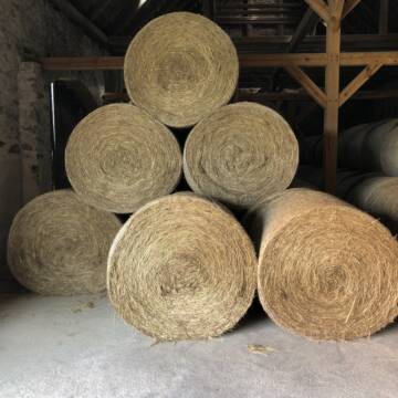
Futtermittel & Einstreu mit Lieferung!
Schwaara
MK-Agrarprodukte
@MK-Agrarprodukte
Heu
Empfänger lädt ab
Großballen
Regenfrei
2 weitere...
P+

Luzerneheu 1.Schnitt
Teutschenthal
Nancy
@Haltergemeinschaft-TT
Heu
Empfänger lädt ab
Rundballen
Regenfrei
2 weitere...
B+
Deprecated: Creation of dynamic property Zend_View_Helper_Ads::$adLink is deprecated in /var/www/stall-frei/htdocs/staging.stall-frei.de/library/Psf/View/Helper/Ads.php on line 108

Leider kein Vorschaubild
Leider kein Vorschaubild
BIO-Heu, 1. Schnitt 2025, Quaderballen (60x40x30)
Tirpersdorf
Forstbaumschule
@Forstbaumschule
Heu
Kleinballen/HD-Ballen
Bio
Regenfrei
Wird verladen
1 weitere...
B+
Leider kein Vorschaubild
Leider kein Vorschaubild
BIO-Heu, 1. Schnitt 2024, Quaderballen (60x40x30)
Tirpersdorf
Forstbaumschule
@Forstbaumschule
Heu
Kleinballen/HD-Ballen
Bio
Regenfrei
Käufer lädt selbst
1 weitere...
aktuell
B+
Leider kein Vorschaubild
Leider kein Vorschaubild
Bio-Heu, 1. Schnitt aus 2024 (BIOLAND) zu verkauf.
Tirpersdorf
Forstbaumschule
@Forstbaumschule
Heu
Empfänger lädt ab
Großballen
Bio
Regenfrei
2 weitere...
B+

Heu und Stroh /Rundballen/Quaderballen
Sandersdorf
jule13
@Jule2024
Stroh
Lieferant entlädt
Rundballen
Regenfrei
3 weitere...
B+
Pferdeheu 1.Schnitt Juli 2025/Rundballen 1.50m
Cavertitz
LWB Streubel
@Landwirtschaftsbetr.-Streubel
Heu
Lieferant entlädt
Rundballen
Bio
Regenfrei
3 weitere...
B+

Job gesucht?
Mechtersen
STALL-FREIde Marketing
@STALL-FREI-Marketing
Sie suchen einen Job und arbeiten gerne mit Pferden oder auf Reitanlagen?
Besuchen Sie jetzt unseren Stellenmarkt!

Haferstroh 1.50m Ernte 25 Ausgezeichnete Qualität
Cavertitz
LWB Streubel
@Landwirtschaftsbetr.-Streubel
Stroh
Lieferant entlädt
Rundballen
Regenfrei
3 weitere...
B+


1 Palette Stramofarm Heupellets 30 Sack á 15Kg
Leinefelde
stramofarm GmbH
@stramofarm
Heu
Lieferant entlädt
Pellets
Regenfrei
2 weitere...
P+


1 Palette Stramofarm Strohpellets 30Sack á 25KG
Leinefelde- Worbis
stramofarm GmbH
@stramofarm
Einstreu
Lieferant entlädt
Pellets
Regenfrei
2 weitere...
P+
Deprecated: Creation of dynamic property Zend_View::$pageCount is deprecated in /var/www/stall-frei/htdocs/staging.stall-frei.de/library/vendor/shardj/zf1-future/library/Zend/View/Abstract.php on line 308
Deprecated: Creation of dynamic property Zend_View::$itemCountPerPage is deprecated in /var/www/stall-frei/htdocs/staging.stall-frei.de/library/vendor/shardj/zf1-future/library/Zend/View/Abstract.php on line 308
Deprecated: Creation of dynamic property Zend_View::$first is deprecated in /var/www/stall-frei/htdocs/staging.stall-frei.de/library/vendor/shardj/zf1-future/library/Zend/View/Abstract.php on line 308
Deprecated: Creation of dynamic property Zend_View::$current is deprecated in /var/www/stall-frei/htdocs/staging.stall-frei.de/library/vendor/shardj/zf1-future/library/Zend/View/Abstract.php on line 308
Deprecated: Creation of dynamic property Zend_View::$last is deprecated in /var/www/stall-frei/htdocs/staging.stall-frei.de/library/vendor/shardj/zf1-future/library/Zend/View/Abstract.php on line 308
Deprecated: Creation of dynamic property Zend_View::$next is deprecated in /var/www/stall-frei/htdocs/staging.stall-frei.de/library/vendor/shardj/zf1-future/library/Zend/View/Abstract.php on line 308
Deprecated: Creation of dynamic property Zend_View::$pagesInRange is deprecated in /var/www/stall-frei/htdocs/staging.stall-frei.de/library/vendor/shardj/zf1-future/library/Zend/View/Abstract.php on line 308
Deprecated: Creation of dynamic property Zend_View::$firstPageInRange is deprecated in /var/www/stall-frei/htdocs/staging.stall-frei.de/library/vendor/shardj/zf1-future/library/Zend/View/Abstract.php on line 308
Deprecated: Creation of dynamic property Zend_View::$lastPageInRange is deprecated in /var/www/stall-frei/htdocs/staging.stall-frei.de/library/vendor/shardj/zf1-future/library/Zend/View/Abstract.php on line 308
Deprecated: Creation of dynamic property Zend_View::$currentItemCount is deprecated in /var/www/stall-frei/htdocs/staging.stall-frei.de/library/vendor/shardj/zf1-future/library/Zend/View/Abstract.php on line 308
Deprecated: Creation of dynamic property Zend_View::$totalItemCount is deprecated in /var/www/stall-frei/htdocs/staging.stall-frei.de/library/vendor/shardj/zf1-future/library/Zend/View/Abstract.php on line 308
Deprecated: Creation of dynamic property Zend_View::$firstItemNumber is deprecated in /var/www/stall-frei/htdocs/staging.stall-frei.de/library/vendor/shardj/zf1-future/library/Zend/View/Abstract.php on line 308
Deprecated: Creation of dynamic property Zend_View::$lastItemNumber is deprecated in /var/www/stall-frei/htdocs/staging.stall-frei.de/library/vendor/shardj/zf1-future/library/Zend/View/Abstract.php on line 308
Deprecated: Creation of dynamic property Zend_View::$router is deprecated in /var/www/stall-frei/htdocs/staging.stall-frei.de/library/vendor/shardj/zf1-future/library/Zend/View/Abstract.php on line 308
Deprecated: Creation of dynamic property Zend_View::$urlParams is deprecated in /var/www/stall-frei/htdocs/staging.stall-frei.de/library/vendor/shardj/zf1-future/library/Zend/View/Abstract.php on line 308
Deprecated: Creation of dynamic property Zend_View::$showAds is deprecated in /var/www/stall-frei/htdocs/staging.stall-frei.de/library/vendor/shardj/zf1-future/library/Zend/View/Abstract.php on line 308
Deprecated: Creation of dynamic property Zend_View::$objectIds is deprecated in /var/www/stall-frei/htdocs/staging.stall-frei.de/library/vendor/shardj/zf1-future/library/Zend/View/Abstract.php on line 308
Deprecated: Creation of dynamic property Zend_View::$showNavbar is deprecated in /var/www/stall-frei/htdocs/staging.stall-frei.de/library/vendor/shardj/zf1-future/library/Zend/View/Abstract.php on line 308
Deprecated: Creation of dynamic property Zend_View::$showBreadcrumb is deprecated in /var/www/stall-frei/htdocs/staging.stall-frei.de/library/vendor/shardj/zf1-future/library/Zend/View/Abstract.php on line 308
Deprecated: Creation of dynamic property Zend_View::$showFooter is deprecated in /var/www/stall-frei/htdocs/staging.stall-frei.de/library/vendor/shardj/zf1-future/library/Zend/View/Abstract.php on line 308
Deprecated: Creation of dynamic property Zend_View::$showInternalAds is deprecated in /var/www/stall-frei/htdocs/staging.stall-frei.de/library/vendor/shardj/zf1-future/library/Zend/View/Abstract.php on line 308
Deprecated: Creation of dynamic property Zend_View::$blNoContent is deprecated in /var/www/stall-frei/htdocs/staging.stall-frei.de/library/vendor/shardj/zf1-future/library/Zend/View/Abstract.php on line 308
Deprecated: Creation of dynamic property Zend_View::$sMetaDesc is deprecated in /var/www/stall-frei/htdocs/staging.stall-frei.de/library/vendor/shardj/zf1-future/library/Zend/View/Abstract.php on line 308
Deprecated: Creation of dynamic property Zend_View::$useGmaps is deprecated in /var/www/stall-frei/htdocs/staging.stall-frei.de/library/vendor/shardj/zf1-future/library/Zend/View/Abstract.php on line 308
Deprecated: Creation of dynamic property Zend_View::$touches is deprecated in /var/www/stall-frei/htdocs/staging.stall-frei.de/library/vendor/shardj/zf1-future/library/Zend/View/Abstract.php on line 308
Deprecated: Creation of dynamic property Zend_View::$oProject is deprecated in /var/www/stall-frei/htdocs/staging.stall-frei.de/library/vendor/shardj/zf1-future/library/Zend/View/Abstract.php on line 308
Deprecated: Creation of dynamic property Zend_View::$pageHeadline is deprecated in /var/www/stall-frei/htdocs/staging.stall-frei.de/library/vendor/shardj/zf1-future/library/Zend/View/Abstract.php on line 308
Deprecated: Creation of dynamic property Zend_View::$disableLocationField is deprecated in /var/www/stall-frei/htdocs/staging.stall-frei.de/library/vendor/shardj/zf1-future/library/Zend/View/Abstract.php on line 308
Deprecated: Creation of dynamic property Zend_View::$isSearch is deprecated in /var/www/stall-frei/htdocs/staging.stall-frei.de/library/vendor/shardj/zf1-future/library/Zend/View/Abstract.php on line 308
Deprecated: Creation of dynamic property Zend_View::$pageTitle is deprecated in /var/www/stall-frei/htdocs/staging.stall-frei.de/library/vendor/shardj/zf1-future/library/Zend/View/Abstract.php on line 308
Deprecated: Creation of dynamic property Psf_Form_Element_Text::$class is deprecated in /var/www/stall-frei/htdocs/staging.stall-frei.de/library/vendor/shardj/zf1-future/library/Zend/Form/Element.php on line 874
Deprecated: Creation of dynamic property Psf_Form_Element_Text::$size is deprecated in /var/www/stall-frei/htdocs/staging.stall-frei.de/library/vendor/shardj/zf1-future/library/Zend/Form/Element.php on line 874
Deprecated: Creation of dynamic property Psf_Form_Element_Text::$placeholder is deprecated in /var/www/stall-frei/htdocs/staging.stall-frei.de/library/vendor/shardj/zf1-future/library/Zend/Form/Element.php on line 874
Deprecated: Creation of dynamic property Psf_Form_Element_Hidden::$class is deprecated in /var/www/stall-frei/htdocs/staging.stall-frei.de/library/vendor/shardj/zf1-future/library/Zend/Form/Element.php on line 874
Deprecated: Creation of dynamic property Psf_Form_Element_Hidden::$class is deprecated in /var/www/stall-frei/htdocs/staging.stall-frei.de/library/vendor/shardj/zf1-future/library/Zend/Form/Element.php on line 874
Deprecated: Creation of dynamic property Psf_Form_Element_Hidden::$class is deprecated in /var/www/stall-frei/htdocs/staging.stall-frei.de/library/vendor/shardj/zf1-future/library/Zend/Form/Element.php on line 874
Deprecated: Creation of dynamic property Psf_Form_Element_Hidden::$class is deprecated in /var/www/stall-frei/htdocs/staging.stall-frei.de/library/vendor/shardj/zf1-future/library/Zend/Form/Element.php on line 874
Deprecated: Creation of dynamic property Psf_Form_Element_Select::$class is deprecated in /var/www/stall-frei/htdocs/staging.stall-frei.de/library/vendor/shardj/zf1-future/library/Zend/Form/Element.php on line 874
Deprecated: Creation of dynamic property Psf_Form_Element_Select::$class is deprecated in /var/www/stall-frei/htdocs/staging.stall-frei.de/library/vendor/shardj/zf1-future/library/Zend/Form/Element.php on line 874
Deprecated: Creation of dynamic property Psf_Form_Element_Select::$class is deprecated in /var/www/stall-frei/htdocs/staging.stall-frei.de/library/vendor/shardj/zf1-future/library/Zend/Form/Element.php on line 874
Deprecated: Creation of dynamic property Psf_Form_Element_Select::$class is deprecated in /var/www/stall-frei/htdocs/staging.stall-frei.de/library/vendor/shardj/zf1-future/library/Zend/Form/Element.php on line 874
Deprecated: Creation of dynamic property Zend_View::$sort is deprecated in /var/www/stall-frei/htdocs/staging.stall-frei.de/library/vendor/shardj/zf1-future/library/Zend/View/Abstract.php on line 308
Deprecated: Creation of dynamic property Zend_View::$searchLocation is deprecated in /var/www/stall-frei/htdocs/staging.stall-frei.de/library/vendor/shardj/zf1-future/library/Zend/View/Abstract.php on line 308
Deprecated: Creation of dynamic property Zend_View::$locationHint is deprecated in /var/www/stall-frei/htdocs/staging.stall-frei.de/library/vendor/shardj/zf1-future/library/Zend/View/Abstract.php on line 308
Psf_GeoCoder_Abstract::getLocation: Hartmannsdorf Get Location CachedOrLive
Psf_GeoCoder_Abstract::getCachedOrLive: Hartmannsdorf
Psf_GeoCoder_OpenCageData::makeApiRequest: response:
Array
(
[documentation] => https://opencagedata.com/api
[licenses] => Array
(
[0] => Array
(
[name] => see attribution guide
[url] => https://opencagedata.com/credits
)
)
[results] => Array
(
[0] => Array
(
[bounds] => Array
(
[northeast] => Array
(
[lat] => 50.966742
[lng] => 11.9850145
)
[southwest] => Array
(
[lat] => 50.9516062
[lng] => 11.9616464
)
)
[components] => Array
(
[ISO_3166-1_alpha-2] => DE
[ISO_3166-1_alpha-3] => DEU
[ISO_3166-2] => Array
(
[0] => DE-TH
)
[_category] => place
[_normalized_city] => Hartmannsdorf
[_type] => village
[continent] => Europe
[country] => Deutschland
[country_code] => de
[county] => Saale-Holzland-Kreis
[municipality] => Heideland-Elstertal-Schkölen
[political_union] => European Union
[state] => Thüringen
[state_code] => TH
[village] => Hartmannsdorf
)
[confidence] => 8
[formatted] => Hartmannsdorf, Thüringen, Deutschland
[geometry] => Array
(
[lat] => 50.9621391
[lng] => 11.9827889
)
)
[1] => Array
(
[bounds] => Array
(
[northeast] => Array
(
[lat] => 50.9003094
[lng] => 12.8273908
)
[southwest] => Array
(
[lat] => 50.8665824
[lng] => 12.7626823
)
)
[components] => Array
(
[ISO_3166-1_alpha-2] => DE
[ISO_3166-1_alpha-3] => DEU
[ISO_3166-2] => Array
(
[0] => DE-SN
)
[_category] => place
[_normalized_city] => Hartmannsdorf
[_type] => village
[continent] => Europe
[country] => Deutschland
[country_code] => de
[county] => Mittelsachsen
[political_union] => European Union
[postcode] => 09232
[state] => Sachsen
[state_code] => SN
[village] => Hartmannsdorf
)
[confidence] => 7
[formatted] => 09232 Hartmannsdorf, Deutschland
[geometry] => Array
(
[lat] => 50.887069
[lng] => 12.8007489
)
)
[2] => Array
(
[bounds] => Array
(
[northeast] => Array
(
[lat] => 50.6262438
[lng] => 12.6157723
)
[southwest] => Array
(
[lat] => 50.55169
[lng] => 12.5043545
)
)
[components] => Array
(
[ISO_3166-1_alpha-2] => DE
[ISO_3166-1_alpha-3] => DEU
[ISO_3166-2] => Array
(
[0] => DE-SN
)
[_category] => place
[_normalized_city] => Hartmannsdorf bei Kirchberg
[_type] => village
[continent] => Europe
[country] => Deutschland
[country_code] => de
[county] => Zwickau
[municipality] => Kirchberg
[political_union] => European Union
[state] => Sachsen
[state_code] => SN
[village] => Hartmannsdorf bei Kirchberg
)
[confidence] => 7
[formatted] => Hartmannsdorf bei Kirchberg, Sachsen, Deutschland
[geometry] => Array
(
[lat] => 50.5903914
[lng] => 12.5472251
)
)
[3] => Array
(
[bounds] => Array
(
[northeast] => Array
(
[lat] => 50.9219184
[lng] => 12.0262743
)
[southwest] => Array
(
[lat] => 50.900494
[lng] => 11.9808102
)
)
[components] => Array
(
[ISO_3166-1_alpha-2] => DE
[ISO_3166-1_alpha-3] => DEU
[ISO_3166-2] => Array
(
[0] => DE-TH
)
[_category] => place
[_normalized_city] => Hartmannsdorf
[_type] => village
[continent] => Europe
[country] => Deutschland
[country_code] => de
[county] => Greiz
[municipality] => Bad Köstritz
[political_union] => European Union
[state] => Thüringen
[state_code] => TH
[village] => Hartmannsdorf
)
[confidence] => 7
[formatted] => Hartmannsdorf, Thüringen, Deutschland
[geometry] => Array
(
[lat] => 50.9107392
[lng] => 12.0079793
)
)
[4] => Array
(
[bounds] => Array
(
[northeast] => Array
(
[lat] => 51.2818547
[lng] => 12.3261643
)
[southwest] => Array
(
[lat] => 51.2418547
[lng] => 12.2861643
)
)
[components] => Array
(
[ISO_3166-1_alpha-2] => DE
[ISO_3166-1_alpha-3] => DEU
[ISO_3166-2] => Array
(
[0] => DE-SN
)
[_category] => place
[_normalized_city] => Leipzig
[_type] => village
[city] => Leipzig
[continent] => Europe
[country] => Deutschland
[country_code] => de
[political_union] => European Union
[postcode] => 04249
[state] => Sachsen
[state_code] => SN
[village] => Hartmannsdorf
)
[confidence] => 7
[formatted] => 04249 Hartmannsdorf, Deutschland
[geometry] => Array
(
[lat] => 51.2618547
[lng] => 12.3061643
)
)
[5] => Array
(
[bounds] => Array
(
[northeast] => Array
(
[lat] => 50.7810957
[lng] => 12.4442554
)
[southwest] => Array
(
[lat] => 50.7410957
[lng] => 12.4042554
)
)
[components] => Array
(
[ISO_3166-1_alpha-2] => DE
[ISO_3166-1_alpha-3] => DEU
[ISO_3166-2] => Array
(
[0] => DE-SN
)
[_category] => place
[_normalized_city] => Zwickau
[_type] => village
[continent] => Europe
[country] => Deutschland
[country_code] => de
[county] => Zwickau
[political_union] => European Union
[postcode] => 08060
[state] => Sachsen
[state_code] => SN
[town] => Zwickau
[village] => Hartmannsdorf
)
[confidence] => 7
[formatted] => 08060 Hartmannsdorf, Deutschland
[geometry] => Array
(
[lat] => 50.7610957
[lng] => 12.4242554
)
)
[6] => Array
(
[bounds] => Array
(
[northeast] => Array
(
[lat] => 50.8508377
[lng] => 13.5766718
)
[southwest] => Array
(
[lat] => 50.8108377
[lng] => 13.5366718
)
)
[components] => Array
(
[ISO_3166-1_alpha-2] => DE
[ISO_3166-1_alpha-3] => DEU
[ISO_3166-2] => Array
(
[0] => DE-SN
)
[_category] => place
[_normalized_city] => Hartmannsdorf-Reichenau
[_type] => village
[city] => Hartmannsdorf-Reichenau
[continent] => Europe
[country] => Deutschland
[country_code] => de
[county] => Sächsische Schweiz-Osterzgebirge
[municipality] => Klingenberg
[political_union] => European Union
[postcode] => 01762
[state] => Sachsen
[state_code] => SN
[village] => Hartmannsdorf
)
[confidence] => 7
[formatted] => 01762 Hartmannsdorf, Deutschland
[geometry] => Array
(
[lat] => 50.8308377
[lng] => 13.5566718
)
)
[7] => Array
(
[bounds] => Array
(
[northeast] => Array
(
[lat] => 51.9974847
[lng] => 13.8958459
)
[southwest] => Array
(
[lat] => 51.9519997
[lng] => 13.8548871
)
)
[components] => Array
(
[ISO_3166-1_alpha-2] => DE
[ISO_3166-1_alpha-3] => DEU
[ISO_3166-2] => Array
(
[0] => DE-BB
)
[_category] => place
[_normalized_city] => Lübben (Spreewald)
[_type] => village
[continent] => Europe
[country] => Deutschland
[country_code] => de
[county] => Dahme-Spreewald
[political_union] => European Union
[state] => Brandenburg
[state_code] => BB
[town] => Lübben (Spreewald)
[village] => Hartmannsdorf
)
[confidence] => 7
[formatted] => Hartmannsdorf, Brandenburg, Deutschland
[geometry] => Array
(
[lat] => 51.9689176
[lng] => 13.884606
)
)
[8] => Array
(
[bounds] => Array
(
[northeast] => Array
(
[lat] => 52.3693111
[lng] => 13.8505131
)
[southwest] => Array
(
[lat] => 52.3293111
[lng] => 13.8105131
)
)
[components] => Array
(
[ISO_3166-1_alpha-2] => DE
[ISO_3166-1_alpha-3] => DEU
[ISO_3166-2] => Array
(
[0] => DE-BB
)
[_category] => place
[_normalized_city] => Hartmannsdorf
[_type] => village
[continent] => Europe
[country] => Deutschland
[country_code] => de
[county] => Oder-Spree
[municipality] => Spreenhagen
[political_union] => European Union
[postcode] => 15229
[state] => Brandenburg
[state_code] => BB
[village] => Hartmannsdorf
)
[confidence] => 7
[formatted] => 15229 Hartmannsdorf, Deutschland
[geometry] => Array
(
[lat] => 52.3493111
[lng] => 13.8305131
)
)
[9] => Array
(
[components] => Array
(
[ISO_3166-1_alpha-2] => FR
[ISO_3166-1_alpha-3] => FRA
[ISO_3166-2] => Array
(
[0] => FR-IDF
[1] => FR-92
)
[_category] => road
[_normalized_city] => Levallois-Perret
[_type] => road
[city] => Levallois-Perret
[continent] => Europe
[country] => France
[country_code] => fr
[county] => Hauts-de-Seine
[local_authority] => Métropole du Grand Paris
[political_union] => European Union
[postcode] => 92300
[road] => Rue Charles Deutschmann
[state] => Île-de-France
[state_code] => IDF
)
[confidence] => 3
[formatted] => Rue Charles Deutschmann, 92300 Levallois-Perret, France
[geometry] => Array
(
[lat] => 48.900049
[lng] => 2.2842
)
)
)
[status] => Array
(
[code] => 200
[message] => OK
)
[stay_informed] => Array
(
[blog] => https://blog.opencagedata.com
[mastodon] => https://en.osm.town/@opencage
)
[thanks] => For using an OpenCage API
[timestamp] => Array
(
[created_http] => Sun, 08 Feb 2026 06:03:09 GMT
[created_unix] => 1770530589
)
[total_results] => 10
)
Psf_GeoCoder_Abstract::convertLocationResult
{"documentation":"https:\/\/opencagedata.com\/api","licenses":[{"name":"see attribution guide","url":"https:\/\/opencagedata.com\/credits"}],"results":[{"bounds":{"northeast":{"lat":50.966742,"lng":11.9850145},"southwest":{"lat":50.9516062,"lng":11.9616464}},"components":{"ISO_3166-1_alpha-2":"DE","ISO_3166-1_alpha-3":"DEU","ISO_3166-2":["DE-TH"],"_category":"place","_normalized_city":"Hartmannsdorf","_type":"village","continent":"Europe","country":"Deutschland","country_code":"de","county":"Saale-Holzland-Kreis","municipality":"Heideland-Elstertal-Schk\u00f6len","political_union":"European Union","state":"Th\u00fcringen","state_code":"TH","village":"Hartmannsdorf"},"confidence":8,"formatted":"Hartmannsdorf, Th\u00fcringen, Deutschland","geometry":{"lat":50.9621391,"lng":11.9827889}},{"bounds":{"northeast":{"lat":50.9003094,"lng":12.8273908},"southwest":{"lat":50.8665824,"lng":12.7626823}},"components":{"ISO_3166-1_alpha-2":"DE","ISO_3166-1_alpha-3":"DEU","ISO_3166-2":["DE-SN"],"_category":"place","_normalized_city":"Hartmannsdorf","_type":"village","continent":"Europe","country":"Deutschland","country_code":"de","county":"Mittelsachsen","political_union":"European Union","postcode":"09232","state":"Sachsen","state_code":"SN","village":"Hartmannsdorf"},"confidence":7,"formatted":"09232 Hartmannsdorf, Deutschland","geometry":{"lat":50.887069,"lng":12.8007489}},{"bounds":{"northeast":{"lat":50.6262438,"lng":12.6157723},"southwest":{"lat":50.55169,"lng":12.5043545}},"components":{"ISO_3166-1_alpha-2":"DE","ISO_3166-1_alpha-3":"DEU","ISO_3166-2":["DE-SN"],"_category":"place","_normalized_city":"Hartmannsdorf bei Kirchberg","_type":"village","continent":"Europe","country":"Deutschland","country_code":"de","county":"Zwickau","municipality":"Kirchberg","political_union":"European Union","state":"Sachsen","state_code":"SN","village":"Hartmannsdorf bei Kirchberg"},"confidence":7,"formatted":"Hartmannsdorf bei Kirchberg, Sachsen, Deutschland","geometry":{"lat":50.5903914,"lng":12.5472251}},{"bounds":{"northeast":{"lat":50.9219184,"lng":12.0262743},"southwest":{"lat":50.900494,"lng":11.9808102}},"components":{"ISO_3166-1_alpha-2":"DE","ISO_3166-1_alpha-3":"DEU","ISO_3166-2":["DE-TH"],"_category":"place","_normalized_city":"Hartmannsdorf","_type":"village","continent":"Europe","country":"Deutschland","country_code":"de","county":"Greiz","municipality":"Bad K\u00f6stritz","political_union":"European Union","state":"Th\u00fcringen","state_code":"TH","village":"Hartmannsdorf"},"confidence":7,"formatted":"Hartmannsdorf, Th\u00fcringen, Deutschland","geometry":{"lat":50.9107392,"lng":12.0079793}},{"bounds":{"northeast":{"lat":51.2818547,"lng":12.3261643},"southwest":{"lat":51.2418547,"lng":12.2861643}},"components":{"ISO_3166-1_alpha-2":"DE","ISO_3166-1_alpha-3":"DEU","ISO_3166-2":["DE-SN"],"_category":"place","_normalized_city":"Leipzig","_type":"village","city":"Leipzig","continent":"Europe","country":"Deutschland","country_code":"de","political_union":"European Union","postcode":"04249","state":"Sachsen","state_code":"SN","village":"Hartmannsdorf"},"confidence":7,"formatted":"04249 Hartmannsdorf, Deutschland","geometry":{"lat":51.2618547,"lng":12.3061643}},{"bounds":{"northeast":{"lat":50.7810957,"lng":12.4442554},"southwest":{"lat":50.7410957,"lng":12.4042554}},"components":{"ISO_3166-1_alpha-2":"DE","ISO_3166-1_alpha-3":"DEU","ISO_3166-2":["DE-SN"],"_category":"place","_normalized_city":"Zwickau","_type":"village","continent":"Europe","country":"Deutschland","country_code":"de","county":"Zwickau","political_union":"European Union","postcode":"08060","state":"Sachsen","state_code":"SN","town":"Zwickau","village":"Hartmannsdorf"},"confidence":7,"formatted":"08060 Hartmannsdorf, Deutschland","geometry":{"lat":50.7610957,"lng":12.4242554}},{"bounds":{"northeast":{"lat":50.8508377,"lng":13.5766718},"southwest":{"lat":50.8108377,"lng":13.5366718}},"components":{"ISO_3166-1_alpha-2":"DE","ISO_3166-1_alpha-3":"DEU","ISO_3166-2":["DE-SN"],"_category":"place","_normalized_city":"Hartmannsdorf-Reichenau","_type":"village","city":"Hartmannsdorf-Reichenau","continent":"Europe","country":"Deutschland","country_code":"de","county":"S\u00e4chsische Schweiz-Osterzgebirge","municipality":"Klingenberg","political_union":"European Union","postcode":"01762","state":"Sachsen","state_code":"SN","village":"Hartmannsdorf"},"confidence":7,"formatted":"01762 Hartmannsdorf, Deutschland","geometry":{"lat":50.8308377,"lng":13.5566718}},{"bounds":{"northeast":{"lat":51.9974847,"lng":13.8958459},"southwest":{"lat":51.9519997,"lng":13.8548871}},"components":{"ISO_3166-1_alpha-2":"DE","ISO_3166-1_alpha-3":"DEU","ISO_3166-2":["DE-BB"],"_category":"place","_normalized_city":"L\u00fcbben (Spreewald)","_type":"village","continent":"Europe","country":"Deutschland","country_code":"de","county":"Dahme-Spreewald","political_union":"European Union","state":"Brandenburg","state_code":"BB","town":"L\u00fcbben (Spreewald)","village":"Hartmannsdorf"},"confidence":7,"formatted":"Hartmannsdorf, Brandenburg, Deutschland","geometry":{"lat":51.9689176,"lng":13.884606}},{"bounds":{"northeast":{"lat":52.3693111,"lng":13.8505131},"southwest":{"lat":52.3293111,"lng":13.8105131}},"components":{"ISO_3166-1_alpha-2":"DE","ISO_3166-1_alpha-3":"DEU","ISO_3166-2":["DE-BB"],"_category":"place","_normalized_city":"Hartmannsdorf","_type":"village","continent":"Europe","country":"Deutschland","country_code":"de","county":"Oder-Spree","municipality":"Spreenhagen","political_union":"European Union","postcode":"15229","state":"Brandenburg","state_code":"BB","village":"Hartmannsdorf"},"confidence":7,"formatted":"15229 Hartmannsdorf, Deutschland","geometry":{"lat":52.3493111,"lng":13.8305131}},{"components":{"ISO_3166-1_alpha-2":"FR","ISO_3166-1_alpha-3":"FRA","ISO_3166-2":["FR-IDF","FR-92"],"_category":"road","_normalized_city":"Levallois-Perret","_type":"road","city":"Levallois-Perret","continent":"Europe","country":"France","country_code":"fr","county":"Hauts-de-Seine","local_authority":"M\u00e9tropole du Grand Paris","political_union":"European Union","postcode":"92300","road":"Rue Charles Deutschmann","state":"\u00cele-de-France","state_code":"IDF"},"confidence":3,"formatted":"Rue Charles Deutschmann, 92300 Levallois-Perret, France","geometry":{"lat":48.900049,"lng":2.2842}}],"status":{"code":200,"message":"OK"},"stay_informed":{"blog":"https:\/\/blog.opencagedata.com","mastodon":"https:\/\/en.osm.town\/@opencage"},"thanks":"For using an OpenCage API","timestamp":{"created_http":"Sun, 08 Feb 2026 06:03:09 GMT","created_unix":1770530589},"total_results":10}Array
(
[0] => stdClass Object
(
[bounds] => stdClass Object
(
[northeast] => stdClass Object
(
[lat] => 50.966742
[lng] => 11.9850145
)
[southwest] => stdClass Object
(
[lat] => 50.9516062
[lng] => 11.9616464
)
)
[components] => stdClass Object
(
[ISO_3166-1_alpha-2] => DE
[ISO_3166-1_alpha-3] => DEU
[ISO_3166-2] => Array
(
[0] => DE-TH
)
[_category] => place
[_normalized_city] => Hartmannsdorf
[_type] => village
[continent] => Europe
[country] => Deutschland
[country_code] => de
[county] => Saale-Holzland-Kreis
[municipality] => Heideland-Elstertal-Schkölen
[political_union] => European Union
[state] => Thüringen
[state_code] => TH
[village] => Hartmannsdorf
)
[confidence] => 8
[formatted] => Hartmannsdorf, Thüringen, Deutschland
[geometry] => stdClass Object
(
[lat] => 50.9621391
[lng] => 11.9827889
)
)
[1] => stdClass Object
(
[bounds] => stdClass Object
(
[northeast] => stdClass Object
(
[lat] => 50.9003094
[lng] => 12.8273908
)
[southwest] => stdClass Object
(
[lat] => 50.8665824
[lng] => 12.7626823
)
)
[components] => stdClass Object
(
[ISO_3166-1_alpha-2] => DE
[ISO_3166-1_alpha-3] => DEU
[ISO_3166-2] => Array
(
[0] => DE-SN
)
[_category] => place
[_normalized_city] => Hartmannsdorf
[_type] => village
[continent] => Europe
[country] => Deutschland
[country_code] => de
[county] => Mittelsachsen
[political_union] => European Union
[postcode] => 09232
[state] => Sachsen
[state_code] => SN
[village] => Hartmannsdorf
)
[confidence] => 7
[formatted] => 09232 Hartmannsdorf, Deutschland
[geometry] => stdClass Object
(
[lat] => 50.887069
[lng] => 12.8007489
)
)
[2] => stdClass Object
(
[bounds] => stdClass Object
(
[northeast] => stdClass Object
(
[lat] => 50.6262438
[lng] => 12.6157723
)
[southwest] => stdClass Object
(
[lat] => 50.55169
[lng] => 12.5043545
)
)
[components] => stdClass Object
(
[ISO_3166-1_alpha-2] => DE
[ISO_3166-1_alpha-3] => DEU
[ISO_3166-2] => Array
(
[0] => DE-SN
)
[_category] => place
[_normalized_city] => Hartmannsdorf bei Kirchberg
[_type] => village
[continent] => Europe
[country] => Deutschland
[country_code] => de
[county] => Zwickau
[municipality] => Kirchberg
[political_union] => European Union
[state] => Sachsen
[state_code] => SN
[village] => Hartmannsdorf bei Kirchberg
)
[confidence] => 7
[formatted] => Hartmannsdorf bei Kirchberg, Sachsen, Deutschland
[geometry] => stdClass Object
(
[lat] => 50.5903914
[lng] => 12.5472251
)
)
[3] => stdClass Object
(
[bounds] => stdClass Object
(
[northeast] => stdClass Object
(
[lat] => 50.9219184
[lng] => 12.0262743
)
[southwest] => stdClass Object
(
[lat] => 50.900494
[lng] => 11.9808102
)
)
[components] => stdClass Object
(
[ISO_3166-1_alpha-2] => DE
[ISO_3166-1_alpha-3] => DEU
[ISO_3166-2] => Array
(
[0] => DE-TH
)
[_category] => place
[_normalized_city] => Hartmannsdorf
[_type] => village
[continent] => Europe
[country] => Deutschland
[country_code] => de
[county] => Greiz
[municipality] => Bad Köstritz
[political_union] => European Union
[state] => Thüringen
[state_code] => TH
[village] => Hartmannsdorf
)
[confidence] => 7
[formatted] => Hartmannsdorf, Thüringen, Deutschland
[geometry] => stdClass Object
(
[lat] => 50.9107392
[lng] => 12.0079793
)
)
[4] => stdClass Object
(
[bounds] => stdClass Object
(
[northeast] => stdClass Object
(
[lat] => 51.2818547
[lng] => 12.3261643
)
[southwest] => stdClass Object
(
[lat] => 51.2418547
[lng] => 12.2861643
)
)
[components] => stdClass Object
(
[ISO_3166-1_alpha-2] => DE
[ISO_3166-1_alpha-3] => DEU
[ISO_3166-2] => Array
(
[0] => DE-SN
)
[_category] => place
[_normalized_city] => Leipzig
[_type] => village
[city] => Leipzig
[continent] => Europe
[country] => Deutschland
[country_code] => de
[political_union] => European Union
[postcode] => 04249
[state] => Sachsen
[state_code] => SN
[village] => Hartmannsdorf
)
[confidence] => 7
[formatted] => 04249 Hartmannsdorf, Deutschland
[geometry] => stdClass Object
(
[lat] => 51.2618547
[lng] => 12.3061643
)
)
[5] => stdClass Object
(
[bounds] => stdClass Object
(
[northeast] => stdClass Object
(
[lat] => 50.7810957
[lng] => 12.4442554
)
[southwest] => stdClass Object
(
[lat] => 50.7410957
[lng] => 12.4042554
)
)
[components] => stdClass Object
(
[ISO_3166-1_alpha-2] => DE
[ISO_3166-1_alpha-3] => DEU
[ISO_3166-2] => Array
(
[0] => DE-SN
)
[_category] => place
[_normalized_city] => Zwickau
[_type] => village
[continent] => Europe
[country] => Deutschland
[country_code] => de
[county] => Zwickau
[political_union] => European Union
[postcode] => 08060
[state] => Sachsen
[state_code] => SN
[town] => Zwickau
[village] => Hartmannsdorf
)
[confidence] => 7
[formatted] => 08060 Hartmannsdorf, Deutschland
[geometry] => stdClass Object
(
[lat] => 50.7610957
[lng] => 12.4242554
)
)
[6] => stdClass Object
(
[bounds] => stdClass Object
(
[northeast] => stdClass Object
(
[lat] => 50.8508377
[lng] => 13.5766718
)
[southwest] => stdClass Object
(
[lat] => 50.8108377
[lng] => 13.5366718
)
)
[components] => stdClass Object
(
[ISO_3166-1_alpha-2] => DE
[ISO_3166-1_alpha-3] => DEU
[ISO_3166-2] => Array
(
[0] => DE-SN
)
[_category] => place
[_normalized_city] => Hartmannsdorf-Reichenau
[_type] => village
[city] => Hartmannsdorf-Reichenau
[continent] => Europe
[country] => Deutschland
[country_code] => de
[county] => Sächsische Schweiz-Osterzgebirge
[municipality] => Klingenberg
[political_union] => European Union
[postcode] => 01762
[state] => Sachsen
[state_code] => SN
[village] => Hartmannsdorf
)
[confidence] => 7
[formatted] => 01762 Hartmannsdorf, Deutschland
[geometry] => stdClass Object
(
[lat] => 50.8308377
[lng] => 13.5566718
)
)
[7] => stdClass Object
(
[bounds] => stdClass Object
(
[northeast] => stdClass Object
(
[lat] => 51.9974847
[lng] => 13.8958459
)
[southwest] => stdClass Object
(
[lat] => 51.9519997
[lng] => 13.8548871
)
)
[components] => stdClass Object
(
[ISO_3166-1_alpha-2] => DE
[ISO_3166-1_alpha-3] => DEU
[ISO_3166-2] => Array
(
[0] => DE-BB
)
[_category] => place
[_normalized_city] => Lübben (Spreewald)
[_type] => village
[continent] => Europe
[country] => Deutschland
[country_code] => de
[county] => Dahme-Spreewald
[political_union] => European Union
[state] => Brandenburg
[state_code] => BB
[town] => Lübben (Spreewald)
[village] => Hartmannsdorf
)
[confidence] => 7
[formatted] => Hartmannsdorf, Brandenburg, Deutschland
[geometry] => stdClass Object
(
[lat] => 51.9689176
[lng] => 13.884606
)
)
[8] => stdClass Object
(
[bounds] => stdClass Object
(
[northeast] => stdClass Object
(
[lat] => 52.3693111
[lng] => 13.8505131
)
[southwest] => stdClass Object
(
[lat] => 52.3293111
[lng] => 13.8105131
)
)
[components] => stdClass Object
(
[ISO_3166-1_alpha-2] => DE
[ISO_3166-1_alpha-3] => DEU
[ISO_3166-2] => Array
(
[0] => DE-BB
)
[_category] => place
[_normalized_city] => Hartmannsdorf
[_type] => village
[continent] => Europe
[country] => Deutschland
[country_code] => de
[county] => Oder-Spree
[municipality] => Spreenhagen
[political_union] => European Union
[postcode] => 15229
[state] => Brandenburg
[state_code] => BB
[village] => Hartmannsdorf
)
[confidence] => 7
[formatted] => 15229 Hartmannsdorf, Deutschland
[geometry] => stdClass Object
(
[lat] => 52.3493111
[lng] => 13.8305131
)
)
[9] => stdClass Object
(
[components] => stdClass Object
(
[ISO_3166-1_alpha-2] => FR
[ISO_3166-1_alpha-3] => FRA
[ISO_3166-2] => Array
(
[0] => FR-IDF
[1] => FR-92
)
[_category] => road
[_normalized_city] => Levallois-Perret
[_type] => road
[city] => Levallois-Perret
[continent] => Europe
[country] => France
[country_code] => fr
[county] => Hauts-de-Seine
[local_authority] => Métropole du Grand Paris
[political_union] => European Union
[postcode] => 92300
[road] => Rue Charles Deutschmann
[state] => Île-de-France
[state_code] => IDF
)
[confidence] => 3
[formatted] => Rue Charles Deutschmann, 92300 Levallois-Perret, France
[geometry] => stdClass Object
(
[lat] => 48.900049
[lng] => 2.2842
)
)
)
Psf_GeoCoder_OpenCageData::getKeyMap: 0
stdClass Object
(
    [bounds] => stdClass Object
        (
            [northeast] => stdClass Object
                (
                    [lat] => 50.966742
                    [lng] => 11.9850145
                )

            [southwest] => stdClass Object
                (
                    [lat] => 50.9516062
                    [lng] => 11.9616464
                )

        )

    [components] => stdClass Object
        (
            [ISO_3166-1_alpha-2] => DE
            [ISO_3166-1_alpha-3] => DEU
            [ISO_3166-2] => Array
                (
                    [0] => DE-TH
                )

            [_category] => place
            [_normalized_city] => Hartmannsdorf
            [_type] => village
            [continent] => Europe
            [country] => Deutschland
            [country_code] => de
            [county] => Saale-Holzland-Kreis
            [municipality] => Heideland-Elstertal-Schkölen
            [political_union] => European Union
            [state] => Thüringen
            [state_code] => TH
            [village] => Hartmannsdorf
        )

    [confidence] => 8
    [formatted] => Hartmannsdorf, Thüringen, Deutschland
    [geometry] => stdClass Object
        (
            [lat] => 50.9621391
            [lng] => 11.9827889
        )

)
Psf_GeoCoder_OpenCageData::getCounty: Saale-Holzland-Kreis
Psf_GeoCoder_OpenCageData::addMissingData REFETCH!
Array
(
    [address] => Hartmannsdorf, Thüringen, Deutschland
    [type] => village
    [street] =>
    [city] => Hartmannsdorf
    [county] => Saale-Holzland-Kreis
    [state] => Thüringen
    [zip] =>
    [country] => Deutschland
    [suburb] =>
    [countrycode] => de
    [latitude] => 50.9621391
    [longitude] => 11.9827889
    [accuracy] => 1
    [confidence] => 8
    [bounds] => stdClass Object
        (
            [northeast] => stdClass Object
                (
                    [lat] => 50.966742
                    [lng] => 11.9850145
                )

            [southwest] => stdClass Object
                (
                    [lat] => 50.9516062
                    [lng] => 11.9616464
                )

        )

)
reformat!
Array
(
    [address] => Hartmannsdorf, Thüringen, Deutschland
    [type] => village
    [street] =>
    [city] => Hartmannsdorf
    [county] => Saale-Holzland-Kreis
    [state] => Thüringen
    [zip] =>
    [country] => Deutschland
    [suburb] =>
    [countrycode] => de
    [latitude] => 50.9621391
    [longitude] => 11.9827889
    [accuracy] => 1
    [confidence] => 8
    [bounds] => stdClass Object
        (
            [northeast] => stdClass Object
                (
                    [lat] => 50.966742
                    [lng] => 11.9850145
                )

            [southwest] => stdClass Object
                (
                    [lat] => 50.9516062
                    [lng] => 11.9616464
                )

        )

    [place] => Hartmannsdorf, Thüringen
    [hash] => b3826ca4244dd627a320f72fdca6917c
)
Psf_GeoCoder_OpenCageData::getKeyMap: 1
stdClass Object
(
    [bounds] => stdClass Object
        (
            [northeast] => stdClass Object
                (
                    [lat] => 50.9003094
                    [lng] => 12.8273908
                )

            [southwest] => stdClass Object
                (
                    [lat] => 50.8665824
                    [lng] => 12.7626823
                )

        )

    [components] => stdClass Object
        (
            [ISO_3166-1_alpha-2] => DE
            [ISO_3166-1_alpha-3] => DEU
            [ISO_3166-2] => Array
                (
                    [0] => DE-SN
                )

            [_category] => place
            [_normalized_city] => Hartmannsdorf
            [_type] => village
            [continent] => Europe
            [country] => Deutschland
            [country_code] => de
            [county] => Mittelsachsen
            [political_union] => European Union
            [postcode] => 09232
            [state] => Sachsen
            [state_code] => SN
            [village] => Hartmannsdorf
        )

    [confidence] => 7
    [formatted] => 09232 Hartmannsdorf, Deutschland
    [geometry] => stdClass Object
        (
            [lat] => 50.887069
            [lng] => 12.8007489
        )

)
Psf_GeoCoder_OpenCageData::getCounty: Mittelsachsen
Psf_GeoCoder_OpenCageData::addMissingData REFETCH!
Array
(
    [address] => 09232 Hartmannsdorf, Deutschland
    [type] => village
    [street] =>
    [city] => Hartmannsdorf
    [county] => Mittelsachsen
    [state] => Sachsen
    [zip] => 09232
    [country] => Deutschland
    [suburb] =>
    [countrycode] => de
    [latitude] => 50.887069
    [longitude] => 12.8007489
    [accuracy] => 1
    [confidence] => 7
    [bounds] => stdClass Object
        (
            [northeast] => stdClass Object
                (
                    [lat] => 50.9003094
                    [lng] => 12.8273908
                )

            [southwest] => stdClass Object
                (
                    [lat] => 50.8665824
                    [lng] => 12.7626823
                )

        )

)
reformat!
Array
(
    [address] => 09232 Hartmannsdorf, Deutschland
    [type] => village
    [street] =>
    [city] => Hartmannsdorf
    [county] => Mittelsachsen
    [state] => Sachsen
    [zip] => 09232
    [country] => Deutschland
    [suburb] =>
    [countrycode] => de
    [latitude] => 50.887069
    [longitude] => 12.8007489
    [accuracy] => 1
    [confidence] => 7
    [bounds] => stdClass Object
        (
            [northeast] => stdClass Object
                (
                    [lat] => 50.9003094
                    [lng] => 12.8273908
                )

            [southwest] => stdClass Object
                (
                    [lat] => 50.8665824
                    [lng] => 12.7626823
                )

        )

    [place] => 09232 Hartmannsdorf, Sachsen
    [hash] => 2d3896db1d2d2981de761d5e4ce9ad29
)
Psf_GeoCoder_OpenCageData::getKeyMap: 2
stdClass Object
(
    [bounds] => stdClass Object
        (
            [northeast] => stdClass Object
                (
                    [lat] => 50.6262438
                    [lng] => 12.6157723
                )

            [southwest] => stdClass Object
                (
                    [lat] => 50.55169
                    [lng] => 12.5043545
                )

        )

    [components] => stdClass Object
        (
            [ISO_3166-1_alpha-2] => DE
            [ISO_3166-1_alpha-3] => DEU
            [ISO_3166-2] => Array
                (
                    [0] => DE-SN
                )

            [_category] => place
            [_normalized_city] => Hartmannsdorf bei Kirchberg
            [_type] => village
            [continent] => Europe
            [country] => Deutschland
            [country_code] => de
            [county] => Zwickau
            [municipality] => Kirchberg
            [political_union] => European Union
            [state] => Sachsen
            [state_code] => SN
            [village] => Hartmannsdorf bei Kirchberg
        )

    [confidence] => 7
    [formatted] => Hartmannsdorf bei Kirchberg, Sachsen, Deutschland
    [geometry] => stdClass Object
        (
            [lat] => 50.5903914
            [lng] => 12.5472251
        )

)
Psf_GeoCoder_OpenCageData::getCounty: Zwickau
Psf_GeoCoder_OpenCageData::addMissingData REFETCH!
Array
(
    [address] => Hartmannsdorf bei Kirchberg, Sachsen, Deutschland
    [type] => village
    [street] =>
    [city] => Hartmannsdorf bei Kirchberg
    [county] => Zwickau
    [state] => Sachsen
    [zip] =>
    [country] => Deutschland
    [suburb] =>
    [countrycode] => de
    [latitude] => 50.5903914
    [longitude] => 12.5472251
    [accuracy] => 1
    [confidence] => 7
    [bounds] => stdClass Object
        (
            [northeast] => stdClass Object
                (
                    [lat] => 50.6262438
                    [lng] => 12.6157723
                )

            [southwest] => stdClass Object
                (
                    [lat] => 50.55169
                    [lng] => 12.5043545
                )

        )

)
reformat!
Array
(
    [address] => Hartmannsdorf bei Kirchberg, Sachsen, Deutschland
    [type] => village
    [street] =>
    [city] => Hartmannsdorf bei Kirchberg
    [county] => Zwickau
    [state] => Sachsen
    [zip] =>
    [country] => Deutschland
    [suburb] =>
    [countrycode] => de
    [latitude] => 50.5903914
    [longitude] => 12.5472251
    [accuracy] => 1
    [confidence] => 7
    [bounds] => stdClass Object
        (
            [northeast] => stdClass Object
                (
                    [lat] => 50.6262438
                    [lng] => 12.6157723
                )

            [southwest] => stdClass Object
                (
                    [lat] => 50.55169
                    [lng] => 12.5043545
                )

        )

    [place] => Hartmannsdorf bei Kirchberg, Sachsen
    [hash] => 399cc15d22259cf6f0e3fda4238c972a
)
Psf_GeoCoder_OpenCageData::getKeyMap: 3
stdClass Object
(
    [bounds] => stdClass Object
        (
            [northeast] => stdClass Object
                (
                    [lat] => 50.9219184
                    [lng] => 12.0262743
                )

            [southwest] => stdClass Object
                (
                    [lat] => 50.900494
                    [lng] => 11.9808102
                )

        )

    [components] => stdClass Object
        (
            [ISO_3166-1_alpha-2] => DE
            [ISO_3166-1_alpha-3] => DEU
            [ISO_3166-2] => Array
                (
                    [0] => DE-TH
                )

            [_category] => place
            [_normalized_city] => Hartmannsdorf
            [_type] => village
            [continent] => Europe
            [country] => Deutschland
            [country_code] => de
            [county] => Greiz
            [municipality] => Bad Köstritz
            [political_union] => European Union
            [state] => Thüringen
            [state_code] => TH
            [village] => Hartmannsdorf
        )

    [confidence] => 7
    [formatted] => Hartmannsdorf, Thüringen, Deutschland
    [geometry] => stdClass Object
        (
            [lat] => 50.9107392
            [lng] => 12.0079793
        )

)
Psf_GeoCoder_OpenCageData::getCounty: Greiz
Psf_GeoCoder_OpenCageData::addMissingData REFETCH!
Array
(
    [address] => Hartmannsdorf, Thüringen, Deutschland
    [type] => village
    [street] =>
    [city] => Hartmannsdorf
    [county] => Greiz
    [state] => Thüringen
    [zip] =>
    [country] => Deutschland
    [suburb] =>
    [countrycode] => de
    [latitude] => 50.9107392
    [longitude] => 12.0079793
    [accuracy] => 1
    [confidence] => 7
    [bounds] => stdClass Object
        (
            [northeast] => stdClass Object
                (
                    [lat] => 50.9219184
                    [lng] => 12.0262743
                )

            [southwest] => stdClass Object
                (
                    [lat] => 50.900494
                    [lng] => 11.9808102
                )

        )

)
reformat!
Array
(
    [address] => Hartmannsdorf, Thüringen, Deutschland
    [type] => village
    [street] =>
    [city] => Hartmannsdorf
    [county] => Greiz
    [state] => Thüringen
    [zip] =>
    [country] => Deutschland
    [suburb] =>
    [countrycode] => de
    [latitude] => 50.9107392
    [longitude] => 12.0079793
    [accuracy] => 1
    [confidence] => 7
    [bounds] => stdClass Object
        (
            [northeast] => stdClass Object
                (
                    [lat] => 50.9219184
                    [lng] => 12.0262743
                )

            [southwest] => stdClass Object
                (
                    [lat] => 50.900494
                    [lng] => 11.9808102
                )

        )

    [place] => Hartmannsdorf, Thüringen
    [hash] => b3826ca4244dd627a320f72fdca6917c
)
Psf_GeoCoder_OpenCageData::getKeyMap: 4
stdClass Object
(
    [bounds] => stdClass Object
        (
            [northeast] => stdClass Object
                (
                    [lat] => 51.2818547
                    [lng] => 12.3261643
                )

            [southwest] => stdClass Object
                (
                    [lat] => 51.2418547
                    [lng] => 12.2861643
                )

        )

    [components] => stdClass Object
        (
            [ISO_3166-1_alpha-2] => DE
            [ISO_3166-1_alpha-3] => DEU
            [ISO_3166-2] => Array
                (
                    [0] => DE-SN
                )

            [_category] => place
            [_normalized_city] => Leipzig
            [_type] => village
            [city] => Leipzig
            [continent] => Europe
            [country] => Deutschland
            [country_code] => de
            [political_union] => European Union
            [postcode] => 04249
            [state] => Sachsen
            [state_code] => SN
            [village] => Hartmannsdorf
        )

    [confidence] => 7
    [formatted] => 04249 Hartmannsdorf, Deutschland
    [geometry] => stdClass Object
        (
            [lat] => 51.2618547
            [lng] => 12.3061643
        )

)
Psf_GeoCoder_OpenCageData::getCounty: Leipzig
Psf_GeoCoder_OpenCageData::addMissingData REFETCH!
Array
(
    [address] => 04249 Hartmannsdorf, Deutschland
    [type] => village
    [street] =>
    [city] => Hartmannsdorf
    [county] => Leipzig
    [state] => Sachsen
    [zip] => 04249
    [country] => Deutschland
    [suburb] =>
    [countrycode] => de
    [latitude] => 51.2618547
    [longitude] => 12.3061643
    [accuracy] => 1
    [confidence] => 7
    [bounds] => stdClass Object
        (
            [northeast] => stdClass Object
                (
                    [lat] => 51.2818547
                    [lng] => 12.3261643
                )

            [southwest] => stdClass Object
                (
                    [lat] => 51.2418547
                    [lng] => 12.2861643
                )

        )

)
reformat!
Array
(
    [address] => 04249 Hartmannsdorf, Deutschland
    [type] => village
    [street] =>
    [city] => Hartmannsdorf
    [county] => Leipzig
    [state] => Sachsen
    [zip] => 04249
    [country] => Deutschland
    [suburb] =>
    [countrycode] => de
    [latitude] => 51.2618547
    [longitude] => 12.3061643
    [accuracy] => 1
    [confidence] => 7
    [bounds] => stdClass Object
        (
            [northeast] => stdClass Object
                (
                    [lat] => 51.2818547
                    [lng] => 12.3261643
                )

            [southwest] => stdClass Object
                (
                    [lat] => 51.2418547
                    [lng] => 12.2861643
                )

        )

    [place] => 04249 Hartmannsdorf, Sachsen
    [hash] => 78cc71f6cea96d265ff6185f2db5bb87
)
Psf_GeoCoder_OpenCageData::getKeyMap: 5
stdClass Object
(
    [bounds] => stdClass Object
        (
            [northeast] => stdClass Object
                (
                    [lat] => 50.7810957
                    [lng] => 12.4442554
                )

            [southwest] => stdClass Object
                (
                    [lat] => 50.7410957
                    [lng] => 12.4042554
                )

        )

    [components] => stdClass Object
        (
            [ISO_3166-1_alpha-2] => DE
            [ISO_3166-1_alpha-3] => DEU
            [ISO_3166-2] => Array
                (
                    [0] => DE-SN
                )

            [_category] => place
            [_normalized_city] => Zwickau
            [_type] => village
            [continent] => Europe
            [country] => Deutschland
            [country_code] => de
            [county] => Zwickau
            [political_union] => European Union
            [postcode] => 08060
            [state] => Sachsen
            [state_code] => SN
            [town] => Zwickau
            [village] => Hartmannsdorf
        )

    [confidence] => 7
    [formatted] => 08060 Hartmannsdorf, Deutschland
    [geometry] => stdClass Object
        (
            [lat] => 50.7610957
            [lng] => 12.4242554
        )

)
Psf_GeoCoder_OpenCageData::getCounty: Zwickau
Psf_GeoCoder_OpenCageData::addMissingData REFETCH!
Array
(
    [address] => 08060 Hartmannsdorf, Deutschland
    [type] => village
    [street] =>
    [city] => Zwickau
    [county] => Zwickau
    [state] => Sachsen
    [zip] => 08060
    [country] => Deutschland
    [suburb] =>
    [countrycode] => de
    [latitude] => 50.7610957
    [longitude] => 12.4242554
    [accuracy] => 1
    [confidence] => 7
    [bounds] => stdClass Object
        (
            [northeast] => stdClass Object
                (
                    [lat] => 50.7810957
                    [lng] => 12.4442554
                )

            [southwest] => stdClass Object
                (
                    [lat] => 50.7410957
                    [lng] => 12.4042554
                )

        )

)
reformat!
Array
(
    [address] => 08060 Zwickau
    [type] => village
    [street] =>
    [city] => Zwickau
    [county] => Zwickau
    [state] => Sachsen
    [zip] => 08060
    [country] => Deutschland
    [suburb] =>
    [countrycode] => de
    [latitude] => 50.7610957
    [longitude] => 12.4242554
    [accuracy] => 1
    [confidence] => 7
    [bounds] => stdClass Object
        (
            [northeast] => stdClass Object
                (
                    [lat] => 50.7810957
                    [lng] => 12.4442554
                )

            [southwest] => stdClass Object
                (
                    [lat] => 50.7410957
                    [lng] => 12.4042554
                )

        )

    [place] => 08060 Zwickau, Sachsen
    [hash] => 47ce5a1b5bfa75274f43880812614bd1
)
Psf_GeoCoder_OpenCageData::getKeyMap: 6
stdClass Object
(
    [bounds] => stdClass Object
        (
            [northeast] => stdClass Object
                (
                    [lat] => 50.8508377
                    [lng] => 13.5766718
                )

            [southwest] => stdClass Object
                (
                    [lat] => 50.8108377
                    [lng] => 13.5366718
                )

        )

    [components] => stdClass Object
        (
            [ISO_3166-1_alpha-2] => DE
            [ISO_3166-1_alpha-3] => DEU
            [ISO_3166-2] => Array
                (
                    [0] => DE-SN
                )

            [_category] => place
            [_normalized_city] => Hartmannsdorf-Reichenau
            [_type] => village
            [city] => Hartmannsdorf-Reichenau
            [continent] => Europe
            [country] => Deutschland
            [country_code] => de
            [county] => Sächsische Schweiz-Osterzgebirge
            [municipality] => Klingenberg
            [political_union] => European Union
            [postcode] => 01762
            [state] => Sachsen
            [state_code] => SN
            [village] => Hartmannsdorf
        )

    [confidence] => 7
    [formatted] => 01762 Hartmannsdorf, Deutschland
    [geometry] => stdClass Object
        (
            [lat] => 50.8308377
            [lng] => 13.5566718
        )

)
Psf_GeoCoder_OpenCageData::getCounty: Sächsische Schweiz-Osterzgebirge
Psf_GeoCoder_OpenCageData::addMissingData REFETCH!
Array
(
    [address] => 01762 Hartmannsdorf, Deutschland
    [type] => village
    [street] =>
    [city] => Hartmannsdorf
    [county] => Sächsische Schweiz-Osterzgebirge
    [state] => Sachsen
    [zip] => 01762
    [country] => Deutschland
    [suburb] =>
    [countrycode] => de
    [latitude] => 50.8308377
    [longitude] => 13.5566718
    [accuracy] => 1
    [confidence] => 7
    [bounds] => stdClass Object
        (
            [northeast] => stdClass Object
                (
                    [lat] => 50.8508377
                    [lng] => 13.5766718
                )

            [southwest] => stdClass Object
                (
                    [lat] => 50.8108377
                    [lng] => 13.5366718
                )

        )

)
reformat!
Array
(
    [address] => 01762 Hartmannsdorf, Deutschland
    [type] => village
    [street] =>
    [city] => Hartmannsdorf
    [county] => Sächsische Schweiz-Osterzgebirge
    [state] => Sachsen
    [zip] => 01762
    [country] => Deutschland
    [suburb] =>
    [countrycode] => de
    [latitude] => 50.8308377
    [longitude] => 13.5566718
    [accuracy] => 1
    [confidence] => 7
    [bounds] => stdClass Object
        (
            [northeast] => stdClass Object
                (
                    [lat] => 50.8508377
                    [lng] => 13.5766718
                )

            [southwest] => stdClass Object
                (
                    [lat] => 50.8108377
                    [lng] => 13.5366718
                )

        )

    [place] => 01762 Hartmannsdorf, Sachsen
    [hash] => ad966e45ceb2aac4a48668180f58d65f
)
Psf_GeoCoder_OpenCageData::getKeyMap: 7
stdClass Object
(
    [bounds] => stdClass Object
        (
            [northeast] => stdClass Object
                (
                    [lat] => 51.9974847
                    [lng] => 13.8958459
                )

            [southwest] => stdClass Object
                (
                    [lat] => 51.9519997
                    [lng] => 13.8548871
                )

        )

    [components] => stdClass Object
        (
            [ISO_3166-1_alpha-2] => DE
            [ISO_3166-1_alpha-3] => DEU
            [ISO_3166-2] => Array
                (
                    [0] => DE-BB
                )

            [_category] => place
            [_normalized_city] => Lübben (Spreewald)
            [_type] => village
            [continent] => Europe
            [country] => Deutschland
            [country_code] => de
            [county] => Dahme-Spreewald
            [political_union] => European Union
            [state] => Brandenburg
            [state_code] => BB
            [town] => Lübben (Spreewald)
            [village] => Hartmannsdorf
        )

    [confidence] => 7
    [formatted] => Hartmannsdorf, Brandenburg, Deutschland
    [geometry] => stdClass Object
        (
            [lat] => 51.9689176
            [lng] => 13.884606
        )

)
Psf_GeoCoder_OpenCageData::getCounty: Dahme-Spreewald
Psf_GeoCoder_OpenCageData::addMissingData REFETCH!
Array
(
    [address] => Hartmannsdorf, Brandenburg, Deutschland
    [type] => village
    [street] =>
    [city] => Lübben (Spreewald)
    [county] => Dahme-Spreewald
    [state] => Brandenburg
    [zip] =>
    [country] => Deutschland
    [suburb] =>
    [countrycode] => de
    [latitude] => 51.9689176
    [longitude] => 13.884606
    [accuracy] => 1
    [confidence] => 7
    [bounds] => stdClass Object
        (
            [northeast] => stdClass Object
                (
                    [lat] => 51.9974847
                    [lng] => 13.8958459
                )

            [southwest] => stdClass Object
                (
                    [lat] => 51.9519997
                    [lng] => 13.8548871
                )

        )

)
reformat!
Array
(
    [address] => Lübben (Spreewald)
    [type] => village
    [street] =>
    [city] => Lübben (Spreewald)
    [county] => Dahme-Spreewald
    [state] => Brandenburg
    [zip] =>
    [country] => Deutschland
    [suburb] =>
    [countrycode] => de
    [latitude] => 51.9689176
    [longitude] => 13.884606
    [accuracy] => 1
    [confidence] => 7
    [bounds] => stdClass Object
        (
            [northeast] => stdClass Object
                (
                    [lat] => 51.9974847
                    [lng] => 13.8958459
                )

            [southwest] => stdClass Object
                (
                    [lat] => 51.9519997
                    [lng] => 13.8548871
                )

        )

    [place] => Lübben (Spreewald), Brandenburg
    [hash] => 27b7e075831df5c13590571b1a90111d
)
Psf_GeoCoder_OpenCageData::getKeyMap: 8
stdClass Object
(
    [bounds] => stdClass Object
        (
            [northeast] => stdClass Object
                (
                    [lat] => 52.3693111
                    [lng] => 13.8505131
                )

            [southwest] => stdClass Object
                (
                    [lat] => 52.3293111
                    [lng] => 13.8105131
                )

        )

    [components] => stdClass Object
        (
            [ISO_3166-1_alpha-2] => DE
            [ISO_3166-1_alpha-3] => DEU
            [ISO_3166-2] => Array
                (
                    [0] => DE-BB
                )

            [_category] => place
            [_normalized_city] => Hartmannsdorf
            [_type] => village
            [continent] => Europe
            [country] => Deutschland
            [country_code] => de
            [county] => Oder-Spree
            [municipality] => Spreenhagen
            [political_union] => European Union
            [postcode] => 15229
            [state] => Brandenburg
            [state_code] => BB
            [village] => Hartmannsdorf
        )

    [confidence] => 7
    [formatted] => 15229 Hartmannsdorf, Deutschland
    [geometry] => stdClass Object
        (
            [lat] => 52.3493111
            [lng] => 13.8305131
        )

)
Psf_GeoCoder_OpenCageData::getCounty: Oder-Spree
Psf_GeoCoder_OpenCageData::addMissingData REFETCH!
Array
(
    [address] => 15229 Hartmannsdorf, Deutschland
    [type] => village
    [street] =>
    [city] => Hartmannsdorf
    [county] => Oder-Spree
    [state] => Brandenburg
    [zip] => 15229
    [country] => Deutschland
    [suburb] =>
    [countrycode] => de
    [latitude] => 52.3493111
    [longitude] => 13.8305131
    [accuracy] => 1
    [confidence] => 7
    [bounds] => stdClass Object
        (
            [northeast] => stdClass Object
                (
                    [lat] => 52.3693111
                    [lng] => 13.8505131
                )

            [southwest] => stdClass Object
                (
                    [lat] => 52.3293111
                    [lng] => 13.8105131
                )

        )

)
reformat!
Array
(
    [address] => 15229 Hartmannsdorf, Deutschland
    [type] => village
    [street] =>
    [city] => Hartmannsdorf
    [county] => Oder-Spree
    [state] => Brandenburg
    [zip] => 15229
    [country] => Deutschland
    [suburb] =>
    [countrycode] => de
    [latitude] => 52.3493111
    [longitude] => 13.8305131
    [accuracy] => 1
    [confidence] => 7
    [bounds] => stdClass Object
        (
            [northeast] => stdClass Object
                (
                    [lat] => 52.3693111
                    [lng] => 13.8505131
                )

            [southwest] => stdClass Object
                (
                    [lat] => 52.3293111
                    [lng] => 13.8105131
                )

        )

    [place] => 15229 Hartmannsdorf, Brandenburg
    [hash] => 56dd3b94cf78694d80f4f8beabad3bd5
)
Psf_GeoCoder_OpenCageData::getKeyMap: 9
stdClass Object
(
    [components] => stdClass Object
        (
            [ISO_3166-1_alpha-2] => FR
            [ISO_3166-1_alpha-3] => FRA
            [ISO_3166-2] => Array
                (
                    [0] => FR-IDF
                    [1] => FR-92
                )

            [_category] => road
            [_normalized_city] => Levallois-Perret
            [_type] => road
            [city] => Levallois-Perret
            [continent] => Europe
            [country] => France
            [country_code] => fr
            [county] => Hauts-de-Seine
            [local_authority] => Métropole du Grand Paris
            [political_union] => European Union
            [postcode] => 92300
            [road] => Rue Charles Deutschmann
            [state] => Île-de-France
            [state_code] => IDF
        )

    [confidence] => 3
    [formatted] => Rue Charles Deutschmann, 92300 Levallois-Perret, France
    [geometry] => stdClass Object
        (
            [lat] => 48.900049
            [lng] => 2.2842
        )

)
Psf_GeoCoder_OpenCageData::getCounty: Hauts-de-Seine
Psf_GeoCoder_OpenCageData::addMissingData REFETCH!
Array
(
    [address] => Rue Charles Deutschmann, 92300 Levallois-Perret, France
    [type] => road
    [street] => Rue Charles Deutschmann
    [city] => Levallois-Perret
    [county] => Hauts-de-Seine
    [state] => Île-de-France
    [zip] => 92300
    [country] => France
    [suburb] =>
    [countrycode] => fr
    [latitude] => 48.900049
    [longitude] => 2.2842
    [accuracy] => 1
    [confidence] => 3
    [bounds] =>
)
reformat!
Array
(
    [address] => Rue Charles Deutschmann, 92300 Levallois-Perret, France
    [type] => road
    [street] => Rue Charles Deutschmann
    [city] => Levallois-Perret
    [county] => Hauts-de-Seine
    [state] => Île-de-France
    [zip] => 92300
    [country] => France
    [suburb] =>
    [countrycode] => fr
    [latitude] => 48.900049
    [longitude] => 2.2842
    [accuracy] => 1
    [confidence] => 3
    [bounds] =>
    [place] => Rue Charles Deutschmann, 92300 Levallois-Perret, Île-de-France
    [hash] => b7dc44def3990e8a7eaf18e019eca466
)
Deprecated: Creation of dynamic property Zend_View::$locationHintStyle is deprecated in /var/www/stall-frei/htdocs/staging.stall-frei.de/library/vendor/shardj/zf1-future/library/Zend/View/Abstract.php on line 308
Deprecated: Creation of dynamic property Zend_View::$adGeoLocation is deprecated in /var/www/stall-frei/htdocs/staging.stall-frei.de/library/vendor/shardj/zf1-future/library/Zend/View/Abstract.php on line 308
Deprecated: Creation of dynamic property Zend_View::$recordCount is deprecated in /var/www/stall-frei/htdocs/staging.stall-frei.de/library/vendor/shardj/zf1-future/library/Zend/View/Abstract.php on line 308
Deprecated: explode(): Passing null to parameter #2 ($string) of type string is deprecated in /var/www/stall-frei/htdocs/staging.stall-frei.de/application/models/SearchAgent.php on line 100
Deprecated: explode(): Passing null to parameter #2 ($string) of type string is deprecated in /var/www/stall-frei/htdocs/staging.stall-frei.de/application/models/SearchAgent.php on line 100
Deprecated: explode(): Passing null to parameter #2 ($string) of type string is deprecated in /var/www/stall-frei/htdocs/staging.stall-frei.de/application/models/SearchAgent.php on line 100
Deprecated: explode(): Passing null to parameter #2 ($string) of type string is deprecated in /var/www/stall-frei/htdocs/staging.stall-frei.de/application/models/SearchAgent.php on line 100
Deprecated: explode(): Passing null to parameter #2 ($string) of type string is deprecated in /var/www/stall-frei/htdocs/staging.stall-frei.de/application/models/SearchAgent.php on line 100
Deprecated: explode(): Passing null to parameter #2 ($string) of type string is deprecated in /var/www/stall-frei/htdocs/staging.stall-frei.de/application/models/SearchAgent.php on line 100
Deprecated: trim(): Passing null to parameter #1 ($string) of type string is deprecated in /var/www/stall-frei/htdocs/staging.stall-frei.de/application/models/Account/Search.php on line 82
Warning: Cannot modify header information - headers already sent by (output started at /var/www/stall-frei/htdocs/staging.stall-frei.de/library/vendor/shardj/zf1-future/library/Zend/View/Abstract.php:308) in /var/www/stall-frei/htdocs/staging.stall-frei.de/application/models/Account/Search.php on line 71
Deprecated: Creation of dynamic property Zend_View::$paginationParams is deprecated in /var/www/stall-frei/htdocs/staging.stall-frei.de/library/vendor/shardj/zf1-future/library/Zend/View/Abstract.php on line 308
Deprecated: Creation of dynamic property Zend_View::$objectPaginator is deprecated in /var/www/stall-frei/htdocs/staging.stall-frei.de/library/vendor/shardj/zf1-future/library/Zend/View/Abstract.php on line 308
Deprecated: Creation of dynamic property Zend_View::$featuredObjects is deprecated in /var/www/stall-frei/htdocs/staging.stall-frei.de/library/vendor/shardj/zf1-future/library/Zend/View/Abstract.php on line 308
Deprecated: Creation of dynamic property Zend_View::$hints is deprecated in /var/www/stall-frei/htdocs/staging.stall-frei.de/library/vendor/shardj/zf1-future/library/Zend/View/Abstract.php on line 308
Deprecated: Creation of dynamic property Zend_View::$attributeHints is deprecated in /var/www/stall-frei/htdocs/staging.stall-frei.de/library/vendor/shardj/zf1-future/library/Zend/View/Abstract.php on line 308
Deprecated: Creation of dynamic property Zend_View::$oSearchForm is deprecated in /var/www/stall-frei/htdocs/staging.stall-frei.de/library/vendor/shardj/zf1-future/library/Zend/View/Abstract.php on line 308