Deprecated: Creation of dynamic property Zend_View::$sMode is deprecated in /var/www/stall-frei/htdocs/staging.stall-frei.de/library/vendor/shardj/zf1-future/library/Zend/View/Abstract.php on line 308
Heu, Stroh oder Futter in Ziegenrück
Gesucht wird in "Ziegenrück, Thüringen, Deutschland"
95 Einträge
Deprecated: Creation of dynamic property Zend_View::$listObjects is deprecated in /var/www/stall-frei/htdocs/staging.stall-frei.de/library/vendor/shardj/zf1-future/library/Zend/View/Abstract.php on line 308
Deprecated: Creation of dynamic property Zend_View::$listMode is deprecated in /var/www/stall-frei/htdocs/staging.stall-frei.de/library/vendor/shardj/zf1-future/library/Zend/View/Abstract.php on line 308
Deprecated: Creation of dynamic property Zend_View::$renderedObjects is deprecated in /var/www/stall-frei/htdocs/staging.stall-frei.de/library/vendor/shardj/zf1-future/library/Zend/View/Abstract.php on line 308
Deprecated: Creation of dynamic property Zend_View::$index is deprecated in /var/www/stall-frei/htdocs/staging.stall-frei.de/library/vendor/shardj/zf1-future/library/Zend/View/Abstract.php on line 308
Deprecated: Creation of dynamic property Zend_View::$displayMode is deprecated in /var/www/stall-frei/htdocs/staging.stall-frei.de/library/vendor/shardj/zf1-future/library/Zend/View/Abstract.php on line 308
Deprecated: Creation of dynamic property Zend_View::$remarketingIds is deprecated in /var/www/stall-frei/htdocs/staging.stall-frei.de/library/vendor/shardj/zf1-future/library/Zend/View/Abstract.php on line 308
Deprecated: Creation of dynamic property Zend_View::$listItem is deprecated in /var/www/stall-frei/htdocs/staging.stall-frei.de/library/vendor/shardj/zf1-future/library/Zend/View/Abstract.php on line 308
Deprecated: Creation of dynamic property Zend_View::$object is deprecated in /var/www/stall-frei/htdocs/staging.stall-frei.de/library/vendor/shardj/zf1-future/library/Zend/View/Abstract.php on line 308
Deprecated: Creation of dynamic property Zend_View::$attributes is deprecated in /var/www/stall-frei/htdocs/staging.stall-frei.de/library/vendor/shardj/zf1-future/library/Zend/View/Abstract.php on line 308


Futtermittel & Einstreu mit Lieferung!
Schwaara
MK-Agrarprodukte
@MK-Agrarprodukte
Heu
Empfänger lädt ab
Großballen
Regenfrei
2 weitere...
P+
Leider kein Vorschaubild
Leider kein Vorschaubild
BIO-Heu, 1. Schnitt 2024, Quaderballen (60x40x30)
Tirpersdorf
Forstbaumschule
@Forstbaumschule
Heu
Kleinballen/HD-Ballen
Bio
Regenfrei
Käufer lädt selbst
1 weitere...
aktuell
B+
Deprecated: Creation of dynamic property Zend_View_Helper_Ads::$adLink is deprecated in /var/www/stall-frei/htdocs/staging.stall-frei.de/library/Psf/View/Helper/Ads.php on line 108

Pferdepension Hit Aktivstall Kürmerhof
Hohenkammer
Kuermerhof
@Kuermerhof
*******JETZT NEU MIT ENTSTAUBTEM BIOHEU*********
*******Demnächst mit einem Abenteuerspielplatz für Pferde ( Extrem Trail/Pa
Leider kein Vorschaubild
Leider kein Vorschaubild
Bio-Heu, 1. Schnitt aus 2024 (BIOLAND) zu verkauf.
Tirpersdorf
Forstbaumschule
@Forstbaumschule
Heu
Empfänger lädt ab
Großballen
Bio
Regenfrei
2 weitere...
B+
Leider kein Vorschaubild
Leider kein Vorschaubild
BIO-Heu, 1. Schnitt 2025, Quaderballen (60x40x30)
Tirpersdorf
Forstbaumschule
@Forstbaumschule
Heu
Kleinballen/HD-Ballen
Bio
Regenfrei
Wird verladen
1 weitere...
B+

Luzerneheu 1.Schnitt
Teutschenthal
Nancy
@Haltergemeinschaft-TT
Heu
Empfänger lädt ab
Rundballen
Regenfrei
2 weitere...
B+


1 Palette Stramofarm Heupellets 30 Sack á 15Kg
Leinefelde
stramofarm GmbH
@stramofarm
Heu
Lieferant entlädt
Pellets
Regenfrei
2 weitere...
P+

Persönlichkeitsentwicklung mit Pferden
Bad Salzuflen
Katja Dors
@Pferdezeiten
Begleite andere auf ihrem Entwicklungsweg und entdecke die transformative Kraft der pferdegestützten Persönlichkeitsentwicklung !
neu
R


1 Palette Stramofarm Strohpellets 30Sack á 25KG
Leinefelde- Worbis
stramofarm GmbH
@stramofarm
Einstreu
Lieferant entlädt
Pellets
Regenfrei
2 weitere...
P+

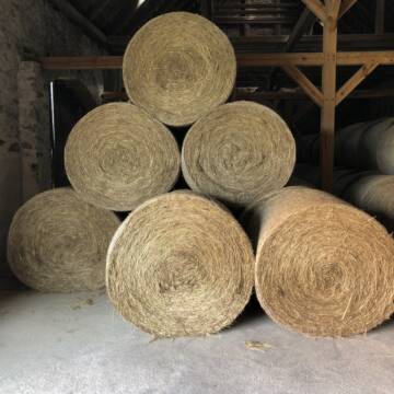
Heu und Stroh /Rundballen/Quaderballen
Sandersdorf
jule13
@Jule2024
Stroh
Lieferant entlädt
Rundballen
Regenfrei
3 weitere...
B+
Pferdeheu 1.Schnitt Juli 2025/Rundballen 1.50m
Cavertitz
LWB Streubel
@Landwirtschaftsbetr.-Streubel
Heu
Lieferant entlädt
Rundballen
Bio
Regenfrei
3 weitere...
B+

Haferstroh 1.50m Ernte 25 Ausgezeichnete Qualität
Cavertitz
LWB Streubel
@Landwirtschaftsbetr.-Streubel
Stroh
Lieferant entlädt
Rundballen
Regenfrei
3 weitere...
B+
Deprecated: Creation of dynamic property Zend_View::$pageCount is deprecated in /var/www/stall-frei/htdocs/staging.stall-frei.de/library/vendor/shardj/zf1-future/library/Zend/View/Abstract.php on line 308
Deprecated: Creation of dynamic property Zend_View::$itemCountPerPage is deprecated in /var/www/stall-frei/htdocs/staging.stall-frei.de/library/vendor/shardj/zf1-future/library/Zend/View/Abstract.php on line 308
Deprecated: Creation of dynamic property Zend_View::$first is deprecated in /var/www/stall-frei/htdocs/staging.stall-frei.de/library/vendor/shardj/zf1-future/library/Zend/View/Abstract.php on line 308
Deprecated: Creation of dynamic property Zend_View::$current is deprecated in /var/www/stall-frei/htdocs/staging.stall-frei.de/library/vendor/shardj/zf1-future/library/Zend/View/Abstract.php on line 308
Deprecated: Creation of dynamic property Zend_View::$last is deprecated in /var/www/stall-frei/htdocs/staging.stall-frei.de/library/vendor/shardj/zf1-future/library/Zend/View/Abstract.php on line 308
Deprecated: Creation of dynamic property Zend_View::$next is deprecated in /var/www/stall-frei/htdocs/staging.stall-frei.de/library/vendor/shardj/zf1-future/library/Zend/View/Abstract.php on line 308
Deprecated: Creation of dynamic property Zend_View::$pagesInRange is deprecated in /var/www/stall-frei/htdocs/staging.stall-frei.de/library/vendor/shardj/zf1-future/library/Zend/View/Abstract.php on line 308
Deprecated: Creation of dynamic property Zend_View::$firstPageInRange is deprecated in /var/www/stall-frei/htdocs/staging.stall-frei.de/library/vendor/shardj/zf1-future/library/Zend/View/Abstract.php on line 308
Deprecated: Creation of dynamic property Zend_View::$lastPageInRange is deprecated in /var/www/stall-frei/htdocs/staging.stall-frei.de/library/vendor/shardj/zf1-future/library/Zend/View/Abstract.php on line 308
Deprecated: Creation of dynamic property Zend_View::$currentItemCount is deprecated in /var/www/stall-frei/htdocs/staging.stall-frei.de/library/vendor/shardj/zf1-future/library/Zend/View/Abstract.php on line 308
Deprecated: Creation of dynamic property Zend_View::$totalItemCount is deprecated in /var/www/stall-frei/htdocs/staging.stall-frei.de/library/vendor/shardj/zf1-future/library/Zend/View/Abstract.php on line 308
Deprecated: Creation of dynamic property Zend_View::$firstItemNumber is deprecated in /var/www/stall-frei/htdocs/staging.stall-frei.de/library/vendor/shardj/zf1-future/library/Zend/View/Abstract.php on line 308
Deprecated: Creation of dynamic property Zend_View::$lastItemNumber is deprecated in /var/www/stall-frei/htdocs/staging.stall-frei.de/library/vendor/shardj/zf1-future/library/Zend/View/Abstract.php on line 308
Deprecated: Creation of dynamic property Zend_View::$router is deprecated in /var/www/stall-frei/htdocs/staging.stall-frei.de/library/vendor/shardj/zf1-future/library/Zend/View/Abstract.php on line 308
Deprecated: Creation of dynamic property Zend_View::$urlParams is deprecated in /var/www/stall-frei/htdocs/staging.stall-frei.de/library/vendor/shardj/zf1-future/library/Zend/View/Abstract.php on line 308
Deprecated: Creation of dynamic property Zend_View::$showAds is deprecated in /var/www/stall-frei/htdocs/staging.stall-frei.de/library/vendor/shardj/zf1-future/library/Zend/View/Abstract.php on line 308
Deprecated: Creation of dynamic property Zend_View::$objectIds is deprecated in /var/www/stall-frei/htdocs/staging.stall-frei.de/library/vendor/shardj/zf1-future/library/Zend/View/Abstract.php on line 308
Deprecated: Creation of dynamic property Zend_View::$showNavbar is deprecated in /var/www/stall-frei/htdocs/staging.stall-frei.de/library/vendor/shardj/zf1-future/library/Zend/View/Abstract.php on line 308
Deprecated: Creation of dynamic property Zend_View::$showBreadcrumb is deprecated in /var/www/stall-frei/htdocs/staging.stall-frei.de/library/vendor/shardj/zf1-future/library/Zend/View/Abstract.php on line 308
Deprecated: Creation of dynamic property Zend_View::$showFooter is deprecated in /var/www/stall-frei/htdocs/staging.stall-frei.de/library/vendor/shardj/zf1-future/library/Zend/View/Abstract.php on line 308
Deprecated: Creation of dynamic property Zend_View::$showInternalAds is deprecated in /var/www/stall-frei/htdocs/staging.stall-frei.de/library/vendor/shardj/zf1-future/library/Zend/View/Abstract.php on line 308
Deprecated: Creation of dynamic property Zend_View::$blNoContent is deprecated in /var/www/stall-frei/htdocs/staging.stall-frei.de/library/vendor/shardj/zf1-future/library/Zend/View/Abstract.php on line 308
Deprecated: Creation of dynamic property Zend_View::$sMetaDesc is deprecated in /var/www/stall-frei/htdocs/staging.stall-frei.de/library/vendor/shardj/zf1-future/library/Zend/View/Abstract.php on line 308
Deprecated: Creation of dynamic property Zend_View::$useGmaps is deprecated in /var/www/stall-frei/htdocs/staging.stall-frei.de/library/vendor/shardj/zf1-future/library/Zend/View/Abstract.php on line 308
Deprecated: Creation of dynamic property Zend_View::$touches is deprecated in /var/www/stall-frei/htdocs/staging.stall-frei.de/library/vendor/shardj/zf1-future/library/Zend/View/Abstract.php on line 308
Deprecated: Creation of dynamic property Zend_View::$oProject is deprecated in /var/www/stall-frei/htdocs/staging.stall-frei.de/library/vendor/shardj/zf1-future/library/Zend/View/Abstract.php on line 308
Deprecated: Creation of dynamic property Zend_View::$pageHeadline is deprecated in /var/www/stall-frei/htdocs/staging.stall-frei.de/library/vendor/shardj/zf1-future/library/Zend/View/Abstract.php on line 308
Deprecated: Creation of dynamic property Zend_View::$disableLocationField is deprecated in /var/www/stall-frei/htdocs/staging.stall-frei.de/library/vendor/shardj/zf1-future/library/Zend/View/Abstract.php on line 308
Deprecated: Creation of dynamic property Zend_View::$isSearch is deprecated in /var/www/stall-frei/htdocs/staging.stall-frei.de/library/vendor/shardj/zf1-future/library/Zend/View/Abstract.php on line 308
Deprecated: Creation of dynamic property Zend_View::$pageTitle is deprecated in /var/www/stall-frei/htdocs/staging.stall-frei.de/library/vendor/shardj/zf1-future/library/Zend/View/Abstract.php on line 308
Deprecated: Creation of dynamic property Psf_Form_Element_Text::$class is deprecated in /var/www/stall-frei/htdocs/staging.stall-frei.de/library/vendor/shardj/zf1-future/library/Zend/Form/Element.php on line 874
Deprecated: Creation of dynamic property Psf_Form_Element_Text::$size is deprecated in /var/www/stall-frei/htdocs/staging.stall-frei.de/library/vendor/shardj/zf1-future/library/Zend/Form/Element.php on line 874
Deprecated: Creation of dynamic property Psf_Form_Element_Text::$placeholder is deprecated in /var/www/stall-frei/htdocs/staging.stall-frei.de/library/vendor/shardj/zf1-future/library/Zend/Form/Element.php on line 874
Deprecated: Creation of dynamic property Psf_Form_Element_Hidden::$class is deprecated in /var/www/stall-frei/htdocs/staging.stall-frei.de/library/vendor/shardj/zf1-future/library/Zend/Form/Element.php on line 874
Deprecated: Creation of dynamic property Psf_Form_Element_Hidden::$class is deprecated in /var/www/stall-frei/htdocs/staging.stall-frei.de/library/vendor/shardj/zf1-future/library/Zend/Form/Element.php on line 874
Deprecated: Creation of dynamic property Psf_Form_Element_Hidden::$class is deprecated in /var/www/stall-frei/htdocs/staging.stall-frei.de/library/vendor/shardj/zf1-future/library/Zend/Form/Element.php on line 874
Deprecated: Creation of dynamic property Psf_Form_Element_Hidden::$class is deprecated in /var/www/stall-frei/htdocs/staging.stall-frei.de/library/vendor/shardj/zf1-future/library/Zend/Form/Element.php on line 874
Deprecated: Creation of dynamic property Psf_Form_Element_Select::$class is deprecated in /var/www/stall-frei/htdocs/staging.stall-frei.de/library/vendor/shardj/zf1-future/library/Zend/Form/Element.php on line 874
Deprecated: Creation of dynamic property Psf_Form_Element_Select::$class is deprecated in /var/www/stall-frei/htdocs/staging.stall-frei.de/library/vendor/shardj/zf1-future/library/Zend/Form/Element.php on line 874
Deprecated: Creation of dynamic property Psf_Form_Element_Select::$class is deprecated in /var/www/stall-frei/htdocs/staging.stall-frei.de/library/vendor/shardj/zf1-future/library/Zend/Form/Element.php on line 874
Deprecated: Creation of dynamic property Psf_Form_Element_Select::$class is deprecated in /var/www/stall-frei/htdocs/staging.stall-frei.de/library/vendor/shardj/zf1-future/library/Zend/Form/Element.php on line 874
Deprecated: Creation of dynamic property Zend_View::$sort is deprecated in /var/www/stall-frei/htdocs/staging.stall-frei.de/library/vendor/shardj/zf1-future/library/Zend/View/Abstract.php on line 308
Deprecated: Creation of dynamic property Zend_View::$searchLocation is deprecated in /var/www/stall-frei/htdocs/staging.stall-frei.de/library/vendor/shardj/zf1-future/library/Zend/View/Abstract.php on line 308
Deprecated: Creation of dynamic property Zend_View::$locationHint is deprecated in /var/www/stall-frei/htdocs/staging.stall-frei.de/library/vendor/shardj/zf1-future/library/Zend/View/Abstract.php on line 308
Psf_GeoCoder_Abstract::getLocation: Ziegenrück Get Location CachedOrLive
Psf_GeoCoder_Abstract::getCachedOrLive: Ziegenrück
Psf_GeoCoder_OpenCageData::makeApiRequest: response:
Array
(
[documentation] => https://opencagedata.com/api
[licenses] => Array
(
[0] => Array
(
[name] => see attribution guide
[url] => https://opencagedata.com/credits
)
)
[results] => Array
(
[0] => Array
(
[bounds] => Array
(
[northeast] => Array
(
[lat] => 50.6304107
[lng] => 11.6832885
)
[southwest] => Array
(
[lat] => 50.5899057
[lng] => 11.6333697
)
)
[components] => Array
(
[ISO_3166-1_alpha-2] => DE
[ISO_3166-1_alpha-3] => DEU
[ISO_3166-2] => Array
(
[0] => DE-TH
)
[_category] => place
[_normalized_city] => Ziegenrück
[_type] => city
[continent] => Europe
[country] => Deutschland
[country_code] => de
[county] => Saale-Orla-Kreis
[municipality] => Ranis-Ziegenrück
[political_union] => European Union
[state] => Thüringen
[state_code] => TH
[town] => Ziegenrück
)
[confidence] => 7
[formatted] => Ziegenrück, Thüringen, Deutschland
[geometry] => Array
(
[lat] => 50.6143209
[lng] => 11.6507127
)
)
[1] => Array
(
[bounds] => Array
(
[northeast] => Array
(
[lat] => 50.5735475
[lng] => 10.7885583
)
[southwest] => Array
(
[lat] => 50.5734475
[lng] => 10.7884583
)
)
[components] => Array
(
[ISO_3166-1_alpha-2] => DE
[ISO_3166-1_alpha-3] => DEU
[ISO_3166-2] => Array
(
[0] => DE-TH
)
[_category] => natural/water
[_normalized_city] => St. Kilian
[_type] => peak
[continent] => Europe
[country] => Deutschland
[country_code] => de
[county] => Landkreis Hildburghausen
[municipality] => Schleusingen
[peak] => Ziegenrück
[political_union] => European Union
[state] => Thüringen
[state_code] => TH
[village] => St. Kilian
)
[confidence] => 9
[formatted] => Ziegenrück, St. Kilian, Thüringen, Deutschland
[geometry] => Array
(
[lat] => 50.5734975
[lng] => 10.7885083
)
)
[2] => Array
(
[bounds] => Array
(
[northeast] => Array
(
[lat] => 50.5839397
[lng] => 11.5037615
)
[southwest] => Array
(
[lat] => 50.5838397
[lng] => 11.5036615
)
)
[components] => Array
(
[ISO_3166-1_alpha-2] => DE
[ISO_3166-1_alpha-3] => DEU
[ISO_3166-2] => Array
(
[0] => DE-TH
)
[_category] => natural/water
[_normalized_city] => Leutenberg
[_type] => peak
[continent] => Europe
[country] => Deutschland
[country_code] => de
[county] => Landkreis Saalfeld-Rudolstadt
[municipality] => Leutenberg
[peak] => Ziegenrück
[political_union] => European Union
[state] => Thüringen
[state_code] => TH
)
[confidence] => 9
[formatted] => Ziegenrück, Leutenberg, Thüringen, Deutschland
[geometry] => Array
(
[lat] => 50.5838897
[lng] => 11.5037115
)
)
[3] => Array
(
[bounds] => Array
(
[northeast] => Array
(
[lat] => 51.4300865
[lng] => 10.4911336
)
[southwest] => Array
(
[lat] => 51.4299865
[lng] => 10.4910336
)
)
[components] => Array
(
[ISO_3166-1_alpha-2] => DE
[ISO_3166-1_alpha-3] => DEU
[ISO_3166-2] => Array
(
[0] => DE-TH
)
[_category] => natural/water
[_normalized_city] => Buhla
[_type] => peak
[continent] => Europe
[country] => Deutschland
[country_code] => de
[county] => Landkreis Eichsfeld
[municipality] => Eichsfeld-Wipperaue
[peak] => Ziegenrück
[political_union] => European Union
[state] => Thüringen
[state_code] => TH
[village] => Buhla
)
[confidence] => 9
[formatted] => Ziegenrück, Buhla, Thüringen, Deutschland
[geometry] => Array
(
[lat] => 51.4300365
[lng] => 10.4910836
)
)
[4] => Array
(
[bounds] => Array
(
[northeast] => Array
(
[lat] => 51.257744
[lng] => 9.0448393
)
[southwest] => Array
(
[lat] => 51.257644
[lng] => 9.0447393
)
)
[components] => Array
(
[ISO_3166-1_alpha-2] => DE
[ISO_3166-1_alpha-3] => DEU
[ISO_3166-2] => Array
(
[0] => DE-HE
)
[_category] => natural/water
[_normalized_city] => Freienhagen
[_type] => peak
[continent] => Europe
[country] => Deutschland
[country_code] => de
[county] => Landkreis Waldeck-Frankenberg
[municipality] => Waldeck
[peak] => Ziegenrück
[political_union] => European Union
[postcode] => 34513
[state] => Hessen
[state_code] => HE
[village] => Freienhagen
)
[confidence] => 9
[formatted] => Ziegenrück, 34513 Freienhagen, Deutschland
[geometry] => Array
(
[lat] => 51.257694
[lng] => 9.0447893
)
)
[5] => Array
(
[bounds] => Array
(
[northeast] => Array
(
[lat] => 50.2488872
[lng] => 11.0228096
)
[southwest] => Array
(
[lat] => 50.2487872
[lng] => 11.0227096
)
)
[components] => Array
(
[ISO_3166-1_alpha-2] => DE
[ISO_3166-1_alpha-3] => DEU
[ISO_3166-2] => Array
(
[0] => DE-BY
)
[_category] => natural/water
[_normalized_city] => Grub a.Forst
[_type] => peak
[continent] => Europe
[country] => Deutschland
[country_code] => de
[county] => Landkreis Coburg
[municipality] => Grub am Forst (VGem)
[peak] => Ziegenrück
[political_union] => European Union
[postcode] => 96271
[state] => Bayern
[state_code] => BY
[village] => Grub a.Forst
)
[confidence] => 9
[formatted] => Ziegenrück, 96271 Grub a.Forst, Deutschland
[geometry] => Array
(
[lat] => 50.2488372
[lng] => 11.0227596
)
)
[6] => Array
(
[bounds] => Array
(
[northeast] => Array
(
[lat] => 50.212981
[lng] => 11.707741
)
[southwest] => Array
(
[lat] => 50.172981
[lng] => 11.667741
)
)
[components] => Array
(
[ISO_3166-1_alpha-2] => DE
[ISO_3166-1_alpha-3] => DEU
[ISO_3166-2] => Array
(
[0] => DE-BY
)
[_category] => place
[_normalized_city] => Münchberg
[_type] => hamlet
[continent] => Europe
[country] => Deutschland
[country_code] => de
[county] => Landkreis Hof
[hamlet] => Ziegenrück
[political_union] => European Union
[postcode] => 95233
[state] => Bayern
[state_code] => BY
[town] => Münchberg
)
[confidence] => 7
[formatted] => Ziegenrück, 95233 Münchberg, Deutschland
[geometry] => Array
(
[lat] => 50.192981
[lng] => 11.687741
)
)
[7] => Array
(
[components] => Array
(
[ISO_3166-1_alpha-2] => FR
[ISO_3166-1_alpha-3] => FRA
[ISO_3166-2] => Array
(
[0] => FR-IDF
[1] => FR-92
)
[_category] => road
[_normalized_city] => Levallois-Perret
[_type] => road
[city] => Levallois-Perret
[continent] => Europe
[country] => France
[country_code] => fr
[county] => Hauts-de-Seine
[local_authority] => Métropole du Grand Paris
[political_union] => European Union
[postcode] => 92300
[road] => Rue Charles Deutschmann
[state] => Île-de-France
[state_code] => IDF
)
[confidence] => 2
[formatted] => Rue Charles Deutschmann, 92300 Levallois-Perret, France
[geometry] => Array
(
[lat] => 48.900049
[lng] => 2.2842
)
)
)
[status] => Array
(
[code] => 200
[message] => OK
)
[stay_informed] => Array
(
[blog] => https://blog.opencagedata.com
[mastodon] => https://en.osm.town/@opencage
)
[thanks] => For using an OpenCage API
[timestamp] => Array
(
[created_http] => Mon, 09 Feb 2026 01:46:26 GMT
[created_unix] => 1770601586
)
[total_results] => 8
)
Psf_GeoCoder_Abstract::convertLocationResult
{"documentation":"https:\/\/opencagedata.com\/api","licenses":[{"name":"see attribution guide","url":"https:\/\/opencagedata.com\/credits"}],"results":[{"bounds":{"northeast":{"lat":50.6304107,"lng":11.6832885},"southwest":{"lat":50.5899057,"lng":11.6333697}},"components":{"ISO_3166-1_alpha-2":"DE","ISO_3166-1_alpha-3":"DEU","ISO_3166-2":["DE-TH"],"_category":"place","_normalized_city":"Ziegenr\u00fcck","_type":"city","continent":"Europe","country":"Deutschland","country_code":"de","county":"Saale-Orla-Kreis","municipality":"Ranis-Ziegenr\u00fcck","political_union":"European Union","state":"Th\u00fcringen","state_code":"TH","town":"Ziegenr\u00fcck"},"confidence":7,"formatted":"Ziegenr\u00fcck, Th\u00fcringen, Deutschland","geometry":{"lat":50.6143209,"lng":11.6507127}},{"bounds":{"northeast":{"lat":50.5735475,"lng":10.7885583},"southwest":{"lat":50.5734475,"lng":10.7884583}},"components":{"ISO_3166-1_alpha-2":"DE","ISO_3166-1_alpha-3":"DEU","ISO_3166-2":["DE-TH"],"_category":"natural\/water","_normalized_city":"St. Kilian","_type":"peak","continent":"Europe","country":"Deutschland","country_code":"de","county":"Landkreis Hildburghausen","municipality":"Schleusingen","peak":"Ziegenr\u00fcck","political_union":"European Union","state":"Th\u00fcringen","state_code":"TH","village":"St. Kilian"},"confidence":9,"formatted":"Ziegenr\u00fcck, St. Kilian, Th\u00fcringen, Deutschland","geometry":{"lat":50.5734975,"lng":10.7885083}},{"bounds":{"northeast":{"lat":50.5839397,"lng":11.5037615},"southwest":{"lat":50.5838397,"lng":11.5036615}},"components":{"ISO_3166-1_alpha-2":"DE","ISO_3166-1_alpha-3":"DEU","ISO_3166-2":["DE-TH"],"_category":"natural\/water","_normalized_city":"Leutenberg","_type":"peak","continent":"Europe","country":"Deutschland","country_code":"de","county":"Landkreis Saalfeld-Rudolstadt","municipality":"Leutenberg","peak":"Ziegenr\u00fcck","political_union":"European Union","state":"Th\u00fcringen","state_code":"TH"},"confidence":9,"formatted":"Ziegenr\u00fcck, Leutenberg, Th\u00fcringen, Deutschland","geometry":{"lat":50.5838897,"lng":11.5037115}},{"bounds":{"northeast":{"lat":51.4300865,"lng":10.4911336},"southwest":{"lat":51.4299865,"lng":10.4910336}},"components":{"ISO_3166-1_alpha-2":"DE","ISO_3166-1_alpha-3":"DEU","ISO_3166-2":["DE-TH"],"_category":"natural\/water","_normalized_city":"Buhla","_type":"peak","continent":"Europe","country":"Deutschland","country_code":"de","county":"Landkreis Eichsfeld","municipality":"Eichsfeld-Wipperaue","peak":"Ziegenr\u00fcck","political_union":"European Union","state":"Th\u00fcringen","state_code":"TH","village":"Buhla"},"confidence":9,"formatted":"Ziegenr\u00fcck, Buhla, Th\u00fcringen, Deutschland","geometry":{"lat":51.4300365,"lng":10.4910836}},{"bounds":{"northeast":{"lat":51.257744,"lng":9.0448393},"southwest":{"lat":51.257644,"lng":9.0447393}},"components":{"ISO_3166-1_alpha-2":"DE","ISO_3166-1_alpha-3":"DEU","ISO_3166-2":["DE-HE"],"_category":"natural\/water","_normalized_city":"Freienhagen","_type":"peak","continent":"Europe","country":"Deutschland","country_code":"de","county":"Landkreis Waldeck-Frankenberg","municipality":"Waldeck","peak":"Ziegenr\u00fcck","political_union":"European Union","postcode":"34513","state":"Hessen","state_code":"HE","village":"Freienhagen"},"confidence":9,"formatted":"Ziegenr\u00fcck, 34513 Freienhagen, Deutschland","geometry":{"lat":51.257694,"lng":9.0447893}},{"bounds":{"northeast":{"lat":50.2488872,"lng":11.0228096},"southwest":{"lat":50.2487872,"lng":11.0227096}},"components":{"ISO_3166-1_alpha-2":"DE","ISO_3166-1_alpha-3":"DEU","ISO_3166-2":["DE-BY"],"_category":"natural\/water","_normalized_city":"Grub a.Forst","_type":"peak","continent":"Europe","country":"Deutschland","country_code":"de","county":"Landkreis Coburg","municipality":"Grub am Forst (VGem)","peak":"Ziegenr\u00fcck","political_union":"European Union","postcode":"96271","state":"Bayern","state_code":"BY","village":"Grub a.Forst"},"confidence":9,"formatted":"Ziegenr\u00fcck, 96271 Grub a.Forst, Deutschland","geometry":{"lat":50.2488372,"lng":11.0227596}},{"bounds":{"northeast":{"lat":50.212981,"lng":11.707741},"southwest":{"lat":50.172981,"lng":11.667741}},"components":{"ISO_3166-1_alpha-2":"DE","ISO_3166-1_alpha-3":"DEU","ISO_3166-2":["DE-BY"],"_category":"place","_normalized_city":"M\u00fcnchberg","_type":"hamlet","continent":"Europe","country":"Deutschland","country_code":"de","county":"Landkreis Hof","hamlet":"Ziegenr\u00fcck","political_union":"European Union","postcode":"95233","state":"Bayern","state_code":"BY","town":"M\u00fcnchberg"},"confidence":7,"formatted":"Ziegenr\u00fcck, 95233 M\u00fcnchberg, Deutschland","geometry":{"lat":50.192981,"lng":11.687741}},{"components":{"ISO_3166-1_alpha-2":"FR","ISO_3166-1_alpha-3":"FRA","ISO_3166-2":["FR-IDF","FR-92"],"_category":"road","_normalized_city":"Levallois-Perret","_type":"road","city":"Levallois-Perret","continent":"Europe","country":"France","country_code":"fr","county":"Hauts-de-Seine","local_authority":"M\u00e9tropole du Grand Paris","political_union":"European Union","postcode":"92300","road":"Rue Charles Deutschmann","state":"\u00cele-de-France","state_code":"IDF"},"confidence":2,"formatted":"Rue Charles Deutschmann, 92300 Levallois-Perret, France","geometry":{"lat":48.900049,"lng":2.2842}}],"status":{"code":200,"message":"OK"},"stay_informed":{"blog":"https:\/\/blog.opencagedata.com","mastodon":"https:\/\/en.osm.town\/@opencage"},"thanks":"For using an OpenCage API","timestamp":{"created_http":"Mon, 09 Feb 2026 01:46:26 GMT","created_unix":1770601586},"total_results":8}Array
(
[0] => stdClass Object
(
[bounds] => stdClass Object
(
[northeast] => stdClass Object
(
[lat] => 50.6304107
[lng] => 11.6832885
)
[southwest] => stdClass Object
(
[lat] => 50.5899057
[lng] => 11.6333697
)
)
[components] => stdClass Object
(
[ISO_3166-1_alpha-2] => DE
[ISO_3166-1_alpha-3] => DEU
[ISO_3166-2] => Array
(
[0] => DE-TH
)
[_category] => place
[_normalized_city] => Ziegenrück
[_type] => city
[continent] => Europe
[country] => Deutschland
[country_code] => de
[county] => Saale-Orla-Kreis
[municipality] => Ranis-Ziegenrück
[political_union] => European Union
[state] => Thüringen
[state_code] => TH
[town] => Ziegenrück
)
[confidence] => 7
[formatted] => Ziegenrück, Thüringen, Deutschland
[geometry] => stdClass Object
(
[lat] => 50.6143209
[lng] => 11.6507127
)
)
[1] => stdClass Object
(
[bounds] => stdClass Object
(
[northeast] => stdClass Object
(
[lat] => 50.5735475
[lng] => 10.7885583
)
[southwest] => stdClass Object
(
[lat] => 50.5734475
[lng] => 10.7884583
)
)
[components] => stdClass Object
(
[ISO_3166-1_alpha-2] => DE
[ISO_3166-1_alpha-3] => DEU
[ISO_3166-2] => Array
(
[0] => DE-TH
)
[_category] => natural/water
[_normalized_city] => St. Kilian
[_type] => peak
[continent] => Europe
[country] => Deutschland
[country_code] => de
[county] => Landkreis Hildburghausen
[municipality] => Schleusingen
[peak] => Ziegenrück
[political_union] => European Union
[state] => Thüringen
[state_code] => TH
[village] => St. Kilian
)
[confidence] => 9
[formatted] => Ziegenrück, St. Kilian, Thüringen, Deutschland
[geometry] => stdClass Object
(
[lat] => 50.5734975
[lng] => 10.7885083
)
)
[2] => stdClass Object
(
[bounds] => stdClass Object
(
[northeast] => stdClass Object
(
[lat] => 50.5839397
[lng] => 11.5037615
)
[southwest] => stdClass Object
(
[lat] => 50.5838397
[lng] => 11.5036615
)
)
[components] => stdClass Object
(
[ISO_3166-1_alpha-2] => DE
[ISO_3166-1_alpha-3] => DEU
[ISO_3166-2] => Array
(
[0] => DE-TH
)
[_category] => natural/water
[_normalized_city] => Leutenberg
[_type] => peak
[continent] => Europe
[country] => Deutschland
[country_code] => de
[county] => Landkreis Saalfeld-Rudolstadt
[municipality] => Leutenberg
[peak] => Ziegenrück
[political_union] => European Union
[state] => Thüringen
[state_code] => TH
)
[confidence] => 9
[formatted] => Ziegenrück, Leutenberg, Thüringen, Deutschland
[geometry] => stdClass Object
(
[lat] => 50.5838897
[lng] => 11.5037115
)
)
[3] => stdClass Object
(
[bounds] => stdClass Object
(
[northeast] => stdClass Object
(
[lat] => 51.4300865
[lng] => 10.4911336
)
[southwest] => stdClass Object
(
[lat] => 51.4299865
[lng] => 10.4910336
)
)
[components] => stdClass Object
(
[ISO_3166-1_alpha-2] => DE
[ISO_3166-1_alpha-3] => DEU
[ISO_3166-2] => Array
(
[0] => DE-TH
)
[_category] => natural/water
[_normalized_city] => Buhla
[_type] => peak
[continent] => Europe
[country] => Deutschland
[country_code] => de
[county] => Landkreis Eichsfeld
[municipality] => Eichsfeld-Wipperaue
[peak] => Ziegenrück
[political_union] => European Union
[state] => Thüringen
[state_code] => TH
[village] => Buhla
)
[confidence] => 9
[formatted] => Ziegenrück, Buhla, Thüringen, Deutschland
[geometry] => stdClass Object
(
[lat] => 51.4300365
[lng] => 10.4910836
)
)
[4] => stdClass Object
(
[bounds] => stdClass Object
(
[northeast] => stdClass Object
(
[lat] => 51.257744
[lng] => 9.0448393
)
[southwest] => stdClass Object
(
[lat] => 51.257644
[lng] => 9.0447393
)
)
[components] => stdClass Object
(
[ISO_3166-1_alpha-2] => DE
[ISO_3166-1_alpha-3] => DEU
[ISO_3166-2] => Array
(
[0] => DE-HE
)
[_category] => natural/water
[_normalized_city] => Freienhagen
[_type] => peak
[continent] => Europe
[country] => Deutschland
[country_code] => de
[county] => Landkreis Waldeck-Frankenberg
[municipality] => Waldeck
[peak] => Ziegenrück
[political_union] => European Union
[postcode] => 34513
[state] => Hessen
[state_code] => HE
[village] => Freienhagen
)
[confidence] => 9
[formatted] => Ziegenrück, 34513 Freienhagen, Deutschland
[geometry] => stdClass Object
(
[lat] => 51.257694
[lng] => 9.0447893
)
)
[5] => stdClass Object
(
[bounds] => stdClass Object
(
[northeast] => stdClass Object
(
[lat] => 50.2488872
[lng] => 11.0228096
)
[southwest] => stdClass Object
(
[lat] => 50.2487872
[lng] => 11.0227096
)
)
[components] => stdClass Object
(
[ISO_3166-1_alpha-2] => DE
[ISO_3166-1_alpha-3] => DEU
[ISO_3166-2] => Array
(
[0] => DE-BY
)
[_category] => natural/water
[_normalized_city] => Grub a.Forst
[_type] => peak
[continent] => Europe
[country] => Deutschland
[country_code] => de
[county] => Landkreis Coburg
[municipality] => Grub am Forst (VGem)
[peak] => Ziegenrück
[political_union] => European Union
[postcode] => 96271
[state] => Bayern
[state_code] => BY
[village] => Grub a.Forst
)
[confidence] => 9
[formatted] => Ziegenrück, 96271 Grub a.Forst, Deutschland
[geometry] => stdClass Object
(
[lat] => 50.2488372
[lng] => 11.0227596
)
)
[6] => stdClass Object
(
[bounds] => stdClass Object
(
[northeast] => stdClass Object
(
[lat] => 50.212981
[lng] => 11.707741
)
[southwest] => stdClass Object
(
[lat] => 50.172981
[lng] => 11.667741
)
)
[components] => stdClass Object
(
[ISO_3166-1_alpha-2] => DE
[ISO_3166-1_alpha-3] => DEU
[ISO_3166-2] => Array
(
[0] => DE-BY
)
[_category] => place
[_normalized_city] => Münchberg
[_type] => hamlet
[continent] => Europe
[country] => Deutschland
[country_code] => de
[county] => Landkreis Hof
[hamlet] => Ziegenrück
[political_union] => European Union
[postcode] => 95233
[state] => Bayern
[state_code] => BY
[town] => Münchberg
)
[confidence] => 7
[formatted] => Ziegenrück, 95233 Münchberg, Deutschland
[geometry] => stdClass Object
(
[lat] => 50.192981
[lng] => 11.687741
)
)
[7] => stdClass Object
(
[components] => stdClass Object
(
[ISO_3166-1_alpha-2] => FR
[ISO_3166-1_alpha-3] => FRA
[ISO_3166-2] => Array
(
[0] => FR-IDF
[1] => FR-92
)
[_category] => road
[_normalized_city] => Levallois-Perret
[_type] => road
[city] => Levallois-Perret
[continent] => Europe
[country] => France
[country_code] => fr
[county] => Hauts-de-Seine
[local_authority] => Métropole du Grand Paris
[political_union] => European Union
[postcode] => 92300
[road] => Rue Charles Deutschmann
[state] => Île-de-France
[state_code] => IDF
)
[confidence] => 2
[formatted] => Rue Charles Deutschmann, 92300 Levallois-Perret, France
[geometry] => stdClass Object
(
[lat] => 48.900049
[lng] => 2.2842
)
)
)
Psf_GeoCoder_OpenCageData::getKeyMap: 0
stdClass Object
(
    [bounds] => stdClass Object
        (
            [northeast] => stdClass Object
                (
                    [lat] => 50.6304107
                    [lng] => 11.6832885
                )

            [southwest] => stdClass Object
                (
                    [lat] => 50.5899057
                    [lng] => 11.6333697
                )

        )

    [components] => stdClass Object
        (
            [ISO_3166-1_alpha-2] => DE
            [ISO_3166-1_alpha-3] => DEU
            [ISO_3166-2] => Array
                (
                    [0] => DE-TH
                )

            [_category] => place
            [_normalized_city] => Ziegenrück
            [_type] => city
            [continent] => Europe
            [country] => Deutschland
            [country_code] => de
            [county] => Saale-Orla-Kreis
            [municipality] => Ranis-Ziegenrück
            [political_union] => European Union
            [state] => Thüringen
            [state_code] => TH
            [town] => Ziegenrück
        )

    [confidence] => 7
    [formatted] => Ziegenrück, Thüringen, Deutschland
    [geometry] => stdClass Object
        (
            [lat] => 50.6143209
            [lng] => 11.6507127
        )

)
Psf_GeoCoder_OpenCageData::getCounty: Saale-Orla-Kreis
Psf_GeoCoder_OpenCageData::addMissingData REFETCH!
Array
(
    [address] => Ziegenrück, Thüringen, Deutschland
    [type] => city
    [street] =>
    [city] => Ziegenrück
    [county] => Saale-Orla-Kreis
    [state] => Thüringen
    [zip] =>
    [country] => Deutschland
    [suburb] =>
    [countrycode] => de
    [latitude] => 50.6143209
    [longitude] => 11.6507127
    [accuracy] => 1
    [confidence] => 7
    [bounds] => stdClass Object
        (
            [northeast] => stdClass Object
                (
                    [lat] => 50.6304107
                    [lng] => 11.6832885
                )

            [southwest] => stdClass Object
                (
                    [lat] => 50.5899057
                    [lng] => 11.6333697
                )

        )

)
reformat!
Array
(
    [address] => Ziegenrück, Thüringen, Deutschland
    [type] => city
    [street] =>
    [city] => Ziegenrück
    [county] => Saale-Orla-Kreis
    [state] => Thüringen
    [zip] =>
    [country] => Deutschland
    [suburb] =>
    [countrycode] => de
    [latitude] => 50.6143209
    [longitude] => 11.6507127
    [accuracy] => 1
    [confidence] => 7
    [bounds] => stdClass Object
        (
            [northeast] => stdClass Object
                (
                    [lat] => 50.6304107
                    [lng] => 11.6832885
                )

            [southwest] => stdClass Object
                (
                    [lat] => 50.5899057
                    [lng] => 11.6333697
                )

        )

    [place] => Ziegenrück, Thüringen
    [hash] => 21465acd2e71a61f733e9217f2fe08ec
)
Psf_GeoCoder_OpenCageData::getKeyMap: 1
stdClass Object
(
    [bounds] => stdClass Object
        (
            [northeast] => stdClass Object
                (
                    [lat] => 50.5735475
                    [lng] => 10.7885583
                )

            [southwest] => stdClass Object
                (
                    [lat] => 50.5734475
                    [lng] => 10.7884583
                )

        )

    [components] => stdClass Object
        (
            [ISO_3166-1_alpha-2] => DE
            [ISO_3166-1_alpha-3] => DEU
            [ISO_3166-2] => Array
                (
                    [0] => DE-TH
                )

            [_category] => natural/water
            [_normalized_city] => St. Kilian
            [_type] => peak
            [continent] => Europe
            [country] => Deutschland
            [country_code] => de
            [county] => Landkreis Hildburghausen
            [municipality] => Schleusingen
            [peak] => Ziegenrück
            [political_union] => European Union
            [state] => Thüringen
            [state_code] => TH
            [village] => St. Kilian
        )

    [confidence] => 9
    [formatted] => Ziegenrück, St. Kilian, Thüringen, Deutschland
    [geometry] => stdClass Object
        (
            [lat] => 50.5734975
            [lng] => 10.7885083
        )

)
Psf_GeoCoder_OpenCageData::getCounty: Hildburghausen
Psf_GeoCoder_OpenCageData::addMissingData REFETCH!
Array
(
    [address] => Ziegenrück, St. Kilian, Thüringen, Deutschland
    [type] => peak
    [street] =>
    [city] => St. Kilian
    [county] => Hildburghausen
    [state] => Thüringen
    [zip] =>
    [country] => Deutschland
    [suburb] =>
    [countrycode] => de
    [latitude] => 50.5734975
    [longitude] => 10.7885083
    [accuracy] => 1
    [confidence] => 9
    [bounds] => stdClass Object
        (
            [northeast] => stdClass Object
                (
                    [lat] => 50.5735475
                    [lng] => 10.7885583
                )

            [southwest] => stdClass Object
                (
                    [lat] => 50.5734475
                    [lng] => 10.7884583
                )

        )

)
reformat!
Array
(
    [address] => Ziegenrück, St. Kilian, Thüringen, Deutschland
    [type] => peak
    [street] =>
    [city] => St. Kilian
    [county] => Hildburghausen
    [state] => Thüringen
    [zip] =>
    [country] => Deutschland
    [suburb] =>
    [countrycode] => de
    [latitude] => 50.5734975
    [longitude] => 10.7885083
    [accuracy] => 1
    [confidence] => 9
    [bounds] => stdClass Object
        (
            [northeast] => stdClass Object
                (
                    [lat] => 50.5735475
                    [lng] => 10.7885583
                )

            [southwest] => stdClass Object
                (
                    [lat] => 50.5734475
                    [lng] => 10.7884583
                )

        )

    [place] => St. Kilian, Thüringen
    [hash] => e8fffc17f1abc9ea9efcbd9f945fc9c0
)
Psf_GeoCoder_OpenCageData::getKeyMap: 2
stdClass Object
(
    [bounds] => stdClass Object
        (
            [northeast] => stdClass Object
                (
                    [lat] => 50.5839397
                    [lng] => 11.5037615
                )

            [southwest] => stdClass Object
                (
                    [lat] => 50.5838397
                    [lng] => 11.5036615
                )

        )

    [components] => stdClass Object
        (
            [ISO_3166-1_alpha-2] => DE
            [ISO_3166-1_alpha-3] => DEU
            [ISO_3166-2] => Array
                (
                    [0] => DE-TH
                )

            [_category] => natural/water
            [_normalized_city] => Leutenberg
            [_type] => peak
            [continent] => Europe
            [country] => Deutschland
            [country_code] => de
            [county] => Landkreis Saalfeld-Rudolstadt
            [municipality] => Leutenberg
            [peak] => Ziegenrück
            [political_union] => European Union
            [state] => Thüringen
            [state_code] => TH
        )

    [confidence] => 9
    [formatted] => Ziegenrück, Leutenberg, Thüringen, Deutschland
    [geometry] => stdClass Object
        (
            [lat] => 50.5838897
            [lng] => 11.5037115
        )

)
Psf_GeoCoder_OpenCageData::getCounty: Saalfeld-Rudolstadt
Psf_GeoCoder_OpenCageData::addMissingData REFETCH!
Array
(
    [address] => Ziegenrück, Leutenberg, Thüringen, Deutschland
    [type] => peak
    [street] =>
    [city] =>
    [county] => Saalfeld-Rudolstadt
    [state] => Thüringen
    [zip] =>
    [country] => Deutschland
    [suburb] =>
    [countrycode] => de
    [latitude] => 50.5838897
    [longitude] => 11.5037115
    [accuracy] => 1
    [confidence] => 9
    [bounds] => stdClass Object
        (
            [northeast] => stdClass Object
                (
                    [lat] => 50.5839397
                    [lng] => 11.5037615
                )

            [southwest] => stdClass Object
                (
                    [lat] => 50.5838397
                    [lng] => 11.5036615
                )

        )

)
reformat!
Array
(
    [address] => Ziegenrück, Leutenberg, Thüringen, Deutschland
    [type] => peak
    [street] =>
    [city] =>
    [county] => Saalfeld-Rudolstadt
    [state] => Thüringen
    [zip] =>
    [country] => Deutschland
    [suburb] =>
    [countrycode] => de
    [latitude] => 50.5838897
    [longitude] => 11.5037115
    [accuracy] => 1
    [confidence] => 9
    [bounds] => stdClass Object
        (
            [northeast] => stdClass Object
                (
                    [lat] => 50.5839397
                    [lng] => 11.5037615
                )

            [southwest] => stdClass Object
                (
                    [lat] => 50.5838397
                    [lng] => 11.5036615
                )

        )

    [place] => , Thüringen
    [hash] => be411ba72f63ba851c285b19a0ee33b0
)
Psf_GeoCoder_OpenCageData::getKeyMap: 3
stdClass Object
(
    [bounds] => stdClass Object
        (
            [northeast] => stdClass Object
                (
                    [lat] => 51.4300865
                    [lng] => 10.4911336
                )

            [southwest] => stdClass Object
                (
                    [lat] => 51.4299865
                    [lng] => 10.4910336
                )

        )

    [components] => stdClass Object
        (
            [ISO_3166-1_alpha-2] => DE
            [ISO_3166-1_alpha-3] => DEU
            [ISO_3166-2] => Array
                (
                    [0] => DE-TH
                )

            [_category] => natural/water
            [_normalized_city] => Buhla
            [_type] => peak
            [continent] => Europe
            [country] => Deutschland
            [country_code] => de
            [county] => Landkreis Eichsfeld
            [municipality] => Eichsfeld-Wipperaue
            [peak] => Ziegenrück
            [political_union] => European Union
            [state] => Thüringen
            [state_code] => TH
            [village] => Buhla
        )

    [confidence] => 9
    [formatted] => Ziegenrück, Buhla, Thüringen, Deutschland
    [geometry] => stdClass Object
        (
            [lat] => 51.4300365
            [lng] => 10.4910836
        )

)
Psf_GeoCoder_OpenCageData::getCounty: Eichsfeld
Psf_GeoCoder_OpenCageData::addMissingData REFETCH!
Array
(
    [address] => Ziegenrück, Buhla, Thüringen, Deutschland
    [type] => peak
    [street] =>
    [city] => Buhla
    [county] => Eichsfeld
    [state] => Thüringen
    [zip] =>
    [country] => Deutschland
    [suburb] =>
    [countrycode] => de
    [latitude] => 51.4300365
    [longitude] => 10.4910836
    [accuracy] => 1
    [confidence] => 9
    [bounds] => stdClass Object
        (
            [northeast] => stdClass Object
                (
                    [lat] => 51.4300865
                    [lng] => 10.4911336
                )

            [southwest] => stdClass Object
                (
                    [lat] => 51.4299865
                    [lng] => 10.4910336
                )

        )

)
reformat!
Array
(
    [address] => Ziegenrück, Buhla, Thüringen, Deutschland
    [type] => peak
    [street] =>
    [city] => Buhla
    [county] => Eichsfeld
    [state] => Thüringen
    [zip] =>
    [country] => Deutschland
    [suburb] =>
    [countrycode] => de
    [latitude] => 51.4300365
    [longitude] => 10.4910836
    [accuracy] => 1
    [confidence] => 9
    [bounds] => stdClass Object
        (
            [northeast] => stdClass Object
                (
                    [lat] => 51.4300865
                    [lng] => 10.4911336
                )

            [southwest] => stdClass Object
                (
                    [lat] => 51.4299865
                    [lng] => 10.4910336
                )

        )

    [place] => Buhla, Thüringen
    [hash] => 5800615941789af1aa5cba87b069f2e1
)
Psf_GeoCoder_OpenCageData::getKeyMap: 4
stdClass Object
(
    [bounds] => stdClass Object
        (
            [northeast] => stdClass Object
                (
                    [lat] => 51.257744
                    [lng] => 9.0448393
                )

            [southwest] => stdClass Object
                (
                    [lat] => 51.257644
                    [lng] => 9.0447393
                )

        )

    [components] => stdClass Object
        (
            [ISO_3166-1_alpha-2] => DE
            [ISO_3166-1_alpha-3] => DEU
            [ISO_3166-2] => Array
                (
                    [0] => DE-HE
                )

            [_category] => natural/water
            [_normalized_city] => Freienhagen
            [_type] => peak
            [continent] => Europe
            [country] => Deutschland
            [country_code] => de
            [county] => Landkreis Waldeck-Frankenberg
            [municipality] => Waldeck
            [peak] => Ziegenrück
            [political_union] => European Union
            [postcode] => 34513
            [state] => Hessen
            [state_code] => HE
            [village] => Freienhagen
        )

    [confidence] => 9
    [formatted] => Ziegenrück, 34513 Freienhagen, Deutschland
    [geometry] => stdClass Object
        (
            [lat] => 51.257694
            [lng] => 9.0447893
        )

)
Psf_GeoCoder_OpenCageData::getCounty: Waldeck-Frankenberg
Psf_GeoCoder_OpenCageData::addMissingData REFETCH!
Array
(
    [address] => Ziegenrück, 34513 Freienhagen, Deutschland
    [type] => peak
    [street] =>
    [city] => Freienhagen
    [county] => Waldeck-Frankenberg
    [state] => Hessen
    [zip] => 34513
    [country] => Deutschland
    [suburb] =>
    [countrycode] => de
    [latitude] => 51.257694
    [longitude] => 9.0447893
    [accuracy] => 1
    [confidence] => 9
    [bounds] => stdClass Object
        (
            [northeast] => stdClass Object
                (
                    [lat] => 51.257744
                    [lng] => 9.0448393
                )

            [southwest] => stdClass Object
                (
                    [lat] => 51.257644
                    [lng] => 9.0447393
                )

        )

)
reformat!
Array
(
    [address] => Ziegenrück, 34513 Freienhagen, Deutschland
    [type] => peak
    [street] =>
    [city] => Freienhagen
    [county] => Waldeck-Frankenberg
    [state] => Hessen
    [zip] => 34513
    [country] => Deutschland
    [suburb] =>
    [countrycode] => de
    [latitude] => 51.257694
    [longitude] => 9.0447893
    [accuracy] => 1
    [confidence] => 9
    [bounds] => stdClass Object
        (
            [northeast] => stdClass Object
                (
                    [lat] => 51.257744
                    [lng] => 9.0448393
                )

            [southwest] => stdClass Object
                (
                    [lat] => 51.257644
                    [lng] => 9.0447393
                )

        )

    [place] => 34513 Freienhagen, Hessen
    [hash] => 282b87aa3f2f697c75d79ff30cdfb149
)
Psf_GeoCoder_OpenCageData::getKeyMap: 5
stdClass Object
(
    [bounds] => stdClass Object
        (
            [northeast] => stdClass Object
                (
                    [lat] => 50.2488872
                    [lng] => 11.0228096
                )

            [southwest] => stdClass Object
                (
                    [lat] => 50.2487872
                    [lng] => 11.0227096
                )

        )

    [components] => stdClass Object
        (
            [ISO_3166-1_alpha-2] => DE
            [ISO_3166-1_alpha-3] => DEU
            [ISO_3166-2] => Array
                (
                    [0] => DE-BY
                )

            [_category] => natural/water
            [_normalized_city] => Grub a.Forst
            [_type] => peak
            [continent] => Europe
            [country] => Deutschland
            [country_code] => de
            [county] => Landkreis Coburg
            [municipality] => Grub am Forst (VGem)
            [peak] => Ziegenrück
            [political_union] => European Union
            [postcode] => 96271
            [state] => Bayern
            [state_code] => BY
            [village] => Grub a.Forst
        )

    [confidence] => 9
    [formatted] => Ziegenrück, 96271 Grub a.Forst, Deutschland
    [geometry] => stdClass Object
        (
            [lat] => 50.2488372
            [lng] => 11.0227596
        )

)
Psf_GeoCoder_OpenCageData::getCounty: Coburg
Psf_GeoCoder_OpenCageData::addMissingData REFETCH!
Array
(
    [address] => Ziegenrück, 96271 Grub a.Forst, Deutschland
    [type] => peak
    [street] =>
    [city] => Grub a.Forst
    [county] => Coburg
    [state] => Bayern
    [zip] => 96271
    [country] => Deutschland
    [suburb] =>
    [countrycode] => de
    [latitude] => 50.2488372
    [longitude] => 11.0227596
    [accuracy] => 1
    [confidence] => 9
    [bounds] => stdClass Object
        (
            [northeast] => stdClass Object
                (
                    [lat] => 50.2488872
                    [lng] => 11.0228096
                )

            [southwest] => stdClass Object
                (
                    [lat] => 50.2487872
                    [lng] => 11.0227096
                )

        )

)
reformat!
Array
(
    [address] => Ziegenrück, 96271 Grub a.Forst, Deutschland
    [type] => peak
    [street] =>
    [city] => Grub a.Forst
    [county] => Coburg
    [state] => Bayern
    [zip] => 96271
    [country] => Deutschland
    [suburb] =>
    [countrycode] => de
    [latitude] => 50.2488372
    [longitude] => 11.0227596
    [accuracy] => 1
    [confidence] => 9
    [bounds] => stdClass Object
        (
            [northeast] => stdClass Object
                (
                    [lat] => 50.2488872
                    [lng] => 11.0228096
                )

            [southwest] => stdClass Object
                (
                    [lat] => 50.2487872
                    [lng] => 11.0227096
                )

        )

    [place] => 96271 Grub a.Forst, Bayern
    [hash] => aec3d831fc8ebe9f400f2306d79b6650
)
Psf_GeoCoder_OpenCageData::getKeyMap: 6
stdClass Object
(
    [bounds] => stdClass Object
        (
            [northeast] => stdClass Object
                (
                    [lat] => 50.212981
                    [lng] => 11.707741
                )

            [southwest] => stdClass Object
                (
                    [lat] => 50.172981
                    [lng] => 11.667741
                )

        )

    [components] => stdClass Object
        (
            [ISO_3166-1_alpha-2] => DE
            [ISO_3166-1_alpha-3] => DEU
            [ISO_3166-2] => Array
                (
                    [0] => DE-BY
                )

            [_category] => place
            [_normalized_city] => Münchberg
            [_type] => hamlet
            [continent] => Europe
            [country] => Deutschland
            [country_code] => de
            [county] => Landkreis Hof
            [hamlet] => Ziegenrück
            [political_union] => European Union
            [postcode] => 95233
            [state] => Bayern
            [state_code] => BY
            [town] => Münchberg
        )

    [confidence] => 7
    [formatted] => Ziegenrück, 95233 Münchberg, Deutschland
    [geometry] => stdClass Object
        (
            [lat] => 50.192981
            [lng] => 11.687741
        )

)
Psf_GeoCoder_OpenCageData::getCounty: Hof
Psf_GeoCoder_OpenCageData::addMissingData REFETCH!
Array
(
    [address] => Ziegenrück, 95233 Münchberg, Deutschland
    [type] => hamlet
    [street] => Ziegenrück
    [city] => Münchberg
    [county] => Hof
    [state] => Bayern
    [zip] => 95233
    [country] => Deutschland
    [suburb] =>
    [countrycode] => de
    [latitude] => 50.192981
    [longitude] => 11.687741
    [accuracy] => 1
    [confidence] => 7
    [bounds] => stdClass Object
        (
            [northeast] => stdClass Object
                (
                    [lat] => 50.212981
                    [lng] => 11.707741
                )

            [southwest] => stdClass Object
                (
                    [lat] => 50.172981
                    [lng] => 11.667741
                )

        )

)
reformat!
Array
(
    [address] => Ziegenrück, 95233 Münchberg, Deutschland
    [type] => hamlet
    [street] => Ziegenrück
    [city] => Münchberg
    [county] => Hof
    [state] => Bayern
    [zip] => 95233
    [country] => Deutschland
    [suburb] =>
    [countrycode] => de
    [latitude] => 50.192981
    [longitude] => 11.687741
    [accuracy] => 1
    [confidence] => 7
    [bounds] => stdClass Object
        (
            [northeast] => stdClass Object
                (
                    [lat] => 50.212981
                    [lng] => 11.707741
                )

            [southwest] => stdClass Object
                (
                    [lat] => 50.172981
                    [lng] => 11.667741
                )

        )

    [place] => Ziegenrück, 95233 Münchberg, Bayern
    [hash] => 884b2ba37b0fd66b6714b8d8cd6a1bb3
)
Psf_GeoCoder_OpenCageData::getKeyMap: 7
stdClass Object
(
    [components] => stdClass Object
        (
            [ISO_3166-1_alpha-2] => FR
            [ISO_3166-1_alpha-3] => FRA
            [ISO_3166-2] => Array
                (
                    [0] => FR-IDF
                    [1] => FR-92
                )

            [_category] => road
            [_normalized_city] => Levallois-Perret
            [_type] => road
            [city] => Levallois-Perret
            [continent] => Europe
            [country] => France
            [country_code] => fr
            [county] => Hauts-de-Seine
            [local_authority] => Métropole du Grand Paris
            [political_union] => European Union
            [postcode] => 92300
            [road] => Rue Charles Deutschmann
            [state] => Île-de-France
            [state_code] => IDF
        )

    [confidence] => 2
    [formatted] => Rue Charles Deutschmann, 92300 Levallois-Perret, France
    [geometry] => stdClass Object
        (
            [lat] => 48.900049
            [lng] => 2.2842
        )

)
Psf_GeoCoder_OpenCageData::getCounty: Hauts-de-Seine
Psf_GeoCoder_OpenCageData::addMissingData REFETCH!
Array
(
    [address] => Rue Charles Deutschmann, 92300 Levallois-Perret, France
    [type] => road
    [street] => Rue Charles Deutschmann
    [city] => Levallois-Perret
    [county] => Hauts-de-Seine
    [state] => Île-de-France
    [zip] => 92300
    [country] => France
    [suburb] =>
    [countrycode] => fr
    [latitude] => 48.900049
    [longitude] => 2.2842
    [accuracy] => 1
    [confidence] => 2
    [bounds] =>
)
reformat!
Array
(
    [address] => Rue Charles Deutschmann, 92300 Levallois-Perret, France
    [type] => road
    [street] => Rue Charles Deutschmann
    [city] => Levallois-Perret
    [county] => Hauts-de-Seine
    [state] => Île-de-France
    [zip] => 92300
    [country] => France
    [suburb] =>
    [countrycode] => fr
    [latitude] => 48.900049
    [longitude] => 2.2842
    [accuracy] => 1
    [confidence] => 2
    [bounds] =>
    [place] => Rue Charles Deutschmann, 92300 Levallois-Perret, Île-de-France
    [hash] => b7dc44def3990e8a7eaf18e019eca466
)
Deprecated: Creation of dynamic property Zend_View::$locationHintStyle is deprecated in /var/www/stall-frei/htdocs/staging.stall-frei.de/library/vendor/shardj/zf1-future/library/Zend/View/Abstract.php on line 308
Deprecated: Creation of dynamic property Zend_View::$adGeoLocation is deprecated in /var/www/stall-frei/htdocs/staging.stall-frei.de/library/vendor/shardj/zf1-future/library/Zend/View/Abstract.php on line 308
Deprecated: Creation of dynamic property Zend_View::$recordCount is deprecated in /var/www/stall-frei/htdocs/staging.stall-frei.de/library/vendor/shardj/zf1-future/library/Zend/View/Abstract.php on line 308
Deprecated: explode(): Passing null to parameter #2 ($string) of type string is deprecated in /var/www/stall-frei/htdocs/staging.stall-frei.de/application/models/SearchAgent.php on line 100
Deprecated: explode(): Passing null to parameter #2 ($string) of type string is deprecated in /var/www/stall-frei/htdocs/staging.stall-frei.de/application/models/SearchAgent.php on line 100
Deprecated: explode(): Passing null to parameter #2 ($string) of type string is deprecated in /var/www/stall-frei/htdocs/staging.stall-frei.de/application/models/SearchAgent.php on line 100
Deprecated: explode(): Passing null to parameter #2 ($string) of type string is deprecated in /var/www/stall-frei/htdocs/staging.stall-frei.de/application/models/SearchAgent.php on line 100
Deprecated: explode(): Passing null to parameter #2 ($string) of type string is deprecated in /var/www/stall-frei/htdocs/staging.stall-frei.de/application/models/SearchAgent.php on line 100
Deprecated: explode(): Passing null to parameter #2 ($string) of type string is deprecated in /var/www/stall-frei/htdocs/staging.stall-frei.de/application/models/SearchAgent.php on line 100
Deprecated: trim(): Passing null to parameter #1 ($string) of type string is deprecated in /var/www/stall-frei/htdocs/staging.stall-frei.de/application/models/Account/Search.php on line 82
Warning: Cannot modify header information - headers already sent by (output started at /var/www/stall-frei/htdocs/staging.stall-frei.de/library/vendor/shardj/zf1-future/library/Zend/View/Abstract.php:308) in /var/www/stall-frei/htdocs/staging.stall-frei.de/application/models/Account/Search.php on line 71
Deprecated: Creation of dynamic property Zend_View::$paginationParams is deprecated in /var/www/stall-frei/htdocs/staging.stall-frei.de/library/vendor/shardj/zf1-future/library/Zend/View/Abstract.php on line 308
Deprecated: Creation of dynamic property Zend_View::$objectPaginator is deprecated in /var/www/stall-frei/htdocs/staging.stall-frei.de/library/vendor/shardj/zf1-future/library/Zend/View/Abstract.php on line 308
Deprecated: Creation of dynamic property Zend_View::$featuredObjects is deprecated in /var/www/stall-frei/htdocs/staging.stall-frei.de/library/vendor/shardj/zf1-future/library/Zend/View/Abstract.php on line 308
Deprecated: Creation of dynamic property Zend_View::$hints is deprecated in /var/www/stall-frei/htdocs/staging.stall-frei.de/library/vendor/shardj/zf1-future/library/Zend/View/Abstract.php on line 308
Deprecated: Creation of dynamic property Zend_View::$attributeHints is deprecated in /var/www/stall-frei/htdocs/staging.stall-frei.de/library/vendor/shardj/zf1-future/library/Zend/View/Abstract.php on line 308
Deprecated: Creation of dynamic property Zend_View::$oSearchForm is deprecated in /var/www/stall-frei/htdocs/staging.stall-frei.de/library/vendor/shardj/zf1-future/library/Zend/View/Abstract.php on line 308