Deprecated: Creation of dynamic property Zend_View::$sMode is deprecated in /var/www/stall-frei/htdocs/staging.stall-frei.de/library/vendor/shardj/zf1-future/library/Zend/View/Abstract.php on line 308
Heu, Stroh oder Futter in Rathen
Gesucht wird in "Rathen, Sachsen, Deutschland"
94 Einträge
Deprecated: Creation of dynamic property Zend_View::$listObjects is deprecated in /var/www/stall-frei/htdocs/staging.stall-frei.de/library/vendor/shardj/zf1-future/library/Zend/View/Abstract.php on line 308
Deprecated: Creation of dynamic property Zend_View::$listMode is deprecated in /var/www/stall-frei/htdocs/staging.stall-frei.de/library/vendor/shardj/zf1-future/library/Zend/View/Abstract.php on line 308
Deprecated: Creation of dynamic property Zend_View::$renderedObjects is deprecated in /var/www/stall-frei/htdocs/staging.stall-frei.de/library/vendor/shardj/zf1-future/library/Zend/View/Abstract.php on line 308
Deprecated: Creation of dynamic property Zend_View::$index is deprecated in /var/www/stall-frei/htdocs/staging.stall-frei.de/library/vendor/shardj/zf1-future/library/Zend/View/Abstract.php on line 308
Deprecated: Creation of dynamic property Zend_View::$displayMode is deprecated in /var/www/stall-frei/htdocs/staging.stall-frei.de/library/vendor/shardj/zf1-future/library/Zend/View/Abstract.php on line 308
Deprecated: Creation of dynamic property Zend_View::$remarketingIds is deprecated in /var/www/stall-frei/htdocs/staging.stall-frei.de/library/vendor/shardj/zf1-future/library/Zend/View/Abstract.php on line 308
Deprecated: Creation of dynamic property Zend_View::$listItem is deprecated in /var/www/stall-frei/htdocs/staging.stall-frei.de/library/vendor/shardj/zf1-future/library/Zend/View/Abstract.php on line 308
Deprecated: Creation of dynamic property Zend_View::$object is deprecated in /var/www/stall-frei/htdocs/staging.stall-frei.de/library/vendor/shardj/zf1-future/library/Zend/View/Abstract.php on line 308
Deprecated: Creation of dynamic property Zend_View::$attributes is deprecated in /var/www/stall-frei/htdocs/staging.stall-frei.de/library/vendor/shardj/zf1-future/library/Zend/View/Abstract.php on line 308
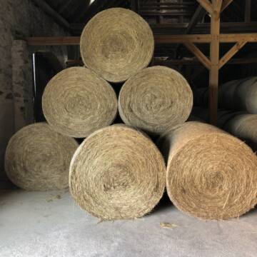
Pferdeheu 1.Schnitt Juli 2025/Rundballen 1.50m
Cavertitz
LWB Streubel
@Landwirtschaftsbetr.-Streubel
Heu
Lieferant entlädt
Rundballen
Bio
Regenfrei
3 weitere...
B+

Haferstroh 1.50m Ernte 25 Ausgezeichnete Qualität
Cavertitz
LWB Streubel
@Landwirtschaftsbetr.-Streubel
Stroh
Lieferant entlädt
Rundballen
Regenfrei
3 weitere...
B+
Deprecated: Creation of dynamic property Zend_View_Helper_Ads::$adLink is deprecated in /var/www/stall-frei/htdocs/staging.stall-frei.de/library/Psf/View/Helper/Ads.php on line 108


Futtermittel & Einstreu mit Lieferung!
Schwaara
MK-Agrarprodukte
@MK-Agrarprodukte
Heu
Empfänger lädt ab
Großballen
Regenfrei
2 weitere...
P+
Leider kein Vorschaubild
Leider kein Vorschaubild
BIO-Heu, 1. Schnitt 2025, Quaderballen (60x40x30)
Tirpersdorf
Forstbaumschule
@Forstbaumschule
Heu
Kleinballen/HD-Ballen
Bio
Regenfrei
Wird verladen
1 weitere...
B+
Leider kein Vorschaubild
Leider kein Vorschaubild
BIO-Heu, 1. Schnitt 2024, Quaderballen (60x40x30)
Tirpersdorf
Forstbaumschule
@Forstbaumschule
Heu
Kleinballen/HD-Ballen
Bio
Regenfrei
Käufer lädt selbst
1 weitere...
aktuell
B+
Leider kein Vorschaubild
Leider kein Vorschaubild
Bio-Heu, 1. Schnitt aus 2024 (BIOLAND) zu verkauf.
Tirpersdorf
Forstbaumschule
@Forstbaumschule
Heu
Empfänger lädt ab
Großballen
Bio
Regenfrei
2 weitere...
B+

Heu und Stroh /Rundballen/Quaderballen
Sandersdorf
jule13
@Jule2024
Stroh
Lieferant entlädt
Rundballen
Regenfrei
3 weitere...
B+

Luzerneheu 1.Schnitt
Teutschenthal
Nancy
@Haltergemeinschaft-TT
Heu
Empfänger lädt ab
Rundballen
Regenfrei
2 weitere...
B+

Futtersack HeuToy, Fressbremse in pink
Mechtersen
STALL-FREIde Marketing
@STALL-FREI-Marketing
Stundenlange Beschäftigung die
Koliken vorbeugt, geringe Staubinhalation mit
steuerbarer Futterentnahme
Leider kein Vorschaubild
Leider kein Vorschaubild
Heu zu verkaufen
Kremmen OT Staffelde
Rhinland Reitpark GmbH
@Rhinland-Reitpark
Heu
Empfänger lädt ab
Rundballen
Regenfrei
3 weitere...
B+

Haferstroh in Futterqualität für gesunde Pferde ...
Schollene
Guthof Mühlenfels
@Gutshof-Muehlenfels
Einstreu
Lieferant entlädt
Großballen
Regenfrei
3 weitere...
B+
Deprecated: Creation of dynamic property Zend_View::$pageCount is deprecated in /var/www/stall-frei/htdocs/staging.stall-frei.de/library/vendor/shardj/zf1-future/library/Zend/View/Abstract.php on line 308
Deprecated: Creation of dynamic property Zend_View::$itemCountPerPage is deprecated in /var/www/stall-frei/htdocs/staging.stall-frei.de/library/vendor/shardj/zf1-future/library/Zend/View/Abstract.php on line 308
Deprecated: Creation of dynamic property Zend_View::$first is deprecated in /var/www/stall-frei/htdocs/staging.stall-frei.de/library/vendor/shardj/zf1-future/library/Zend/View/Abstract.php on line 308
Deprecated: Creation of dynamic property Zend_View::$current is deprecated in /var/www/stall-frei/htdocs/staging.stall-frei.de/library/vendor/shardj/zf1-future/library/Zend/View/Abstract.php on line 308
Deprecated: Creation of dynamic property Zend_View::$last is deprecated in /var/www/stall-frei/htdocs/staging.stall-frei.de/library/vendor/shardj/zf1-future/library/Zend/View/Abstract.php on line 308
Deprecated: Creation of dynamic property Zend_View::$next is deprecated in /var/www/stall-frei/htdocs/staging.stall-frei.de/library/vendor/shardj/zf1-future/library/Zend/View/Abstract.php on line 308
Deprecated: Creation of dynamic property Zend_View::$pagesInRange is deprecated in /var/www/stall-frei/htdocs/staging.stall-frei.de/library/vendor/shardj/zf1-future/library/Zend/View/Abstract.php on line 308
Deprecated: Creation of dynamic property Zend_View::$firstPageInRange is deprecated in /var/www/stall-frei/htdocs/staging.stall-frei.de/library/vendor/shardj/zf1-future/library/Zend/View/Abstract.php on line 308
Deprecated: Creation of dynamic property Zend_View::$lastPageInRange is deprecated in /var/www/stall-frei/htdocs/staging.stall-frei.de/library/vendor/shardj/zf1-future/library/Zend/View/Abstract.php on line 308
Deprecated: Creation of dynamic property Zend_View::$currentItemCount is deprecated in /var/www/stall-frei/htdocs/staging.stall-frei.de/library/vendor/shardj/zf1-future/library/Zend/View/Abstract.php on line 308
Deprecated: Creation of dynamic property Zend_View::$totalItemCount is deprecated in /var/www/stall-frei/htdocs/staging.stall-frei.de/library/vendor/shardj/zf1-future/library/Zend/View/Abstract.php on line 308
Deprecated: Creation of dynamic property Zend_View::$firstItemNumber is deprecated in /var/www/stall-frei/htdocs/staging.stall-frei.de/library/vendor/shardj/zf1-future/library/Zend/View/Abstract.php on line 308
Deprecated: Creation of dynamic property Zend_View::$lastItemNumber is deprecated in /var/www/stall-frei/htdocs/staging.stall-frei.de/library/vendor/shardj/zf1-future/library/Zend/View/Abstract.php on line 308
Deprecated: Creation of dynamic property Zend_View::$router is deprecated in /var/www/stall-frei/htdocs/staging.stall-frei.de/library/vendor/shardj/zf1-future/library/Zend/View/Abstract.php on line 308
Deprecated: Creation of dynamic property Zend_View::$urlParams is deprecated in /var/www/stall-frei/htdocs/staging.stall-frei.de/library/vendor/shardj/zf1-future/library/Zend/View/Abstract.php on line 308
Deprecated: Creation of dynamic property Zend_View::$showAds is deprecated in /var/www/stall-frei/htdocs/staging.stall-frei.de/library/vendor/shardj/zf1-future/library/Zend/View/Abstract.php on line 308
Deprecated: Creation of dynamic property Zend_View::$objectIds is deprecated in /var/www/stall-frei/htdocs/staging.stall-frei.de/library/vendor/shardj/zf1-future/library/Zend/View/Abstract.php on line 308
Deprecated: Creation of dynamic property Zend_View::$showNavbar is deprecated in /var/www/stall-frei/htdocs/staging.stall-frei.de/library/vendor/shardj/zf1-future/library/Zend/View/Abstract.php on line 308
Deprecated: Creation of dynamic property Zend_View::$showBreadcrumb is deprecated in /var/www/stall-frei/htdocs/staging.stall-frei.de/library/vendor/shardj/zf1-future/library/Zend/View/Abstract.php on line 308
Deprecated: Creation of dynamic property Zend_View::$showFooter is deprecated in /var/www/stall-frei/htdocs/staging.stall-frei.de/library/vendor/shardj/zf1-future/library/Zend/View/Abstract.php on line 308
Deprecated: Creation of dynamic property Zend_View::$showInternalAds is deprecated in /var/www/stall-frei/htdocs/staging.stall-frei.de/library/vendor/shardj/zf1-future/library/Zend/View/Abstract.php on line 308
Deprecated: Creation of dynamic property Zend_View::$blNoContent is deprecated in /var/www/stall-frei/htdocs/staging.stall-frei.de/library/vendor/shardj/zf1-future/library/Zend/View/Abstract.php on line 308
Deprecated: Creation of dynamic property Zend_View::$sMetaDesc is deprecated in /var/www/stall-frei/htdocs/staging.stall-frei.de/library/vendor/shardj/zf1-future/library/Zend/View/Abstract.php on line 308
Deprecated: Creation of dynamic property Zend_View::$useGmaps is deprecated in /var/www/stall-frei/htdocs/staging.stall-frei.de/library/vendor/shardj/zf1-future/library/Zend/View/Abstract.php on line 308
Deprecated: Creation of dynamic property Zend_View::$touches is deprecated in /var/www/stall-frei/htdocs/staging.stall-frei.de/library/vendor/shardj/zf1-future/library/Zend/View/Abstract.php on line 308
Deprecated: Creation of dynamic property Zend_View::$oProject is deprecated in /var/www/stall-frei/htdocs/staging.stall-frei.de/library/vendor/shardj/zf1-future/library/Zend/View/Abstract.php on line 308
Deprecated: Creation of dynamic property Zend_View::$pageHeadline is deprecated in /var/www/stall-frei/htdocs/staging.stall-frei.de/library/vendor/shardj/zf1-future/library/Zend/View/Abstract.php on line 308
Deprecated: Creation of dynamic property Zend_View::$disableLocationField is deprecated in /var/www/stall-frei/htdocs/staging.stall-frei.de/library/vendor/shardj/zf1-future/library/Zend/View/Abstract.php on line 308
Deprecated: Creation of dynamic property Zend_View::$isSearch is deprecated in /var/www/stall-frei/htdocs/staging.stall-frei.de/library/vendor/shardj/zf1-future/library/Zend/View/Abstract.php on line 308
Deprecated: Creation of dynamic property Zend_View::$pageTitle is deprecated in /var/www/stall-frei/htdocs/staging.stall-frei.de/library/vendor/shardj/zf1-future/library/Zend/View/Abstract.php on line 308
Deprecated: Creation of dynamic property Psf_Form_Element_Text::$class is deprecated in /var/www/stall-frei/htdocs/staging.stall-frei.de/library/vendor/shardj/zf1-future/library/Zend/Form/Element.php on line 874
Deprecated: Creation of dynamic property Psf_Form_Element_Text::$size is deprecated in /var/www/stall-frei/htdocs/staging.stall-frei.de/library/vendor/shardj/zf1-future/library/Zend/Form/Element.php on line 874
Deprecated: Creation of dynamic property Psf_Form_Element_Text::$placeholder is deprecated in /var/www/stall-frei/htdocs/staging.stall-frei.de/library/vendor/shardj/zf1-future/library/Zend/Form/Element.php on line 874
Deprecated: Creation of dynamic property Psf_Form_Element_Hidden::$class is deprecated in /var/www/stall-frei/htdocs/staging.stall-frei.de/library/vendor/shardj/zf1-future/library/Zend/Form/Element.php on line 874
Deprecated: Creation of dynamic property Psf_Form_Element_Hidden::$class is deprecated in /var/www/stall-frei/htdocs/staging.stall-frei.de/library/vendor/shardj/zf1-future/library/Zend/Form/Element.php on line 874
Deprecated: Creation of dynamic property Psf_Form_Element_Hidden::$class is deprecated in /var/www/stall-frei/htdocs/staging.stall-frei.de/library/vendor/shardj/zf1-future/library/Zend/Form/Element.php on line 874
Deprecated: Creation of dynamic property Psf_Form_Element_Hidden::$class is deprecated in /var/www/stall-frei/htdocs/staging.stall-frei.de/library/vendor/shardj/zf1-future/library/Zend/Form/Element.php on line 874
Deprecated: Creation of dynamic property Psf_Form_Element_Select::$class is deprecated in /var/www/stall-frei/htdocs/staging.stall-frei.de/library/vendor/shardj/zf1-future/library/Zend/Form/Element.php on line 874
Deprecated: Creation of dynamic property Psf_Form_Element_Select::$class is deprecated in /var/www/stall-frei/htdocs/staging.stall-frei.de/library/vendor/shardj/zf1-future/library/Zend/Form/Element.php on line 874
Deprecated: Creation of dynamic property Psf_Form_Element_Select::$class is deprecated in /var/www/stall-frei/htdocs/staging.stall-frei.de/library/vendor/shardj/zf1-future/library/Zend/Form/Element.php on line 874
Deprecated: Creation of dynamic property Psf_Form_Element_Select::$class is deprecated in /var/www/stall-frei/htdocs/staging.stall-frei.de/library/vendor/shardj/zf1-future/library/Zend/Form/Element.php on line 874
Deprecated: Creation of dynamic property Zend_View::$sort is deprecated in /var/www/stall-frei/htdocs/staging.stall-frei.de/library/vendor/shardj/zf1-future/library/Zend/View/Abstract.php on line 308
Deprecated: Creation of dynamic property Zend_View::$searchLocation is deprecated in /var/www/stall-frei/htdocs/staging.stall-frei.de/library/vendor/shardj/zf1-future/library/Zend/View/Abstract.php on line 308
Deprecated: Creation of dynamic property Zend_View::$locationHint is deprecated in /var/www/stall-frei/htdocs/staging.stall-frei.de/library/vendor/shardj/zf1-future/library/Zend/View/Abstract.php on line 308
Psf_GeoCoder_Abstract::getLocation: Rathen Get Location CachedOrLive
Psf_GeoCoder_Abstract::getCachedOrLive: Rathen
Psf_GeoCoder_OpenCageData::makeApiRequest: response:
Array
(
[documentation] => https://opencagedata.com/api
[licenses] => Array
(
[0] => Array
(
[name] => see attribution guide
[url] => https://opencagedata.com/credits
)
)
[results] => Array
(
[0] => Array
(
[bounds] => Array
(
[northeast] => Array
(
[lat] => 50.9661322
[lng] => 14.0983679
)
[southwest] => Array
(
[lat] => 50.93867
[lng] => 14.050628
)
)
[components] => Array
(
[ISO_3166-1_alpha-2] => DE
[ISO_3166-1_alpha-3] => DEU
[ISO_3166-2] => Array
(
[0] => DE-SN
)
[_category] => place
[_normalized_city] => Rathen
[_type] => village
[continent] => Europe
[country] => Deutschland
[country_code] => de
[county] => Sächsische Schweiz-Osterzgebirge
[municipality] => Königstein/Sächs. Schw.
[political_union] => European Union
[state] => Sachsen
[state_code] => SN
[village] => Rathen
)
[confidence] => 7
[formatted] => Rathen, Sachsen, Deutschland
[geometry] => Array
(
[lat] => 50.958235
[lng] => 14.0824651
)
)
[1] => Array
(
[bounds] => Array
(
[northeast] => Array
(
[lat] => 49.5714405
[lng] => 6.9412197
)
[southwest] => Array
(
[lat] => 49.5314405
[lng] => 6.9012197
)
)
[components] => Array
(
[ISO_3166-1_alpha-2] => DE
[ISO_3166-1_alpha-3] => DEU
[ISO_3166-2] => Array
(
[0] => DE-SL
)
[_category] => place
[_normalized_city] => Wadern
[_type] => village
[continent] => Europe
[country] => Deutschland
[country_code] => de
[county] => Landkreis Merzig-Wadern
[political_union] => European Union
[postcode] => 66687
[state] => Saarland
[state_code] => SL
[town] => Wadern
[village] => Rathen
)
[confidence] => 7
[formatted] => 66687 Rathen, Deutschland
[geometry] => Array
(
[lat] => 49.5514405
[lng] => 6.9212197
)
)
[2] => Array
(
[components] => Array
(
[ISO_3166-1_alpha-2] => FR
[ISO_3166-1_alpha-3] => FRA
[ISO_3166-2] => Array
(
[0] => FR-IDF
[1] => FR-92
)
[_category] => road
[_normalized_city] => Levallois-Perret
[_type] => road
[city] => Levallois-Perret
[continent] => Europe
[country] => France
[country_code] => fr
[county] => Hauts-de-Seine
[local_authority] => Métropole du Grand Paris
[political_union] => European Union
[postcode] => 92300
[road] => Rue Charles Deutschmann
[state] => Île-de-France
[state_code] => IDF
)
[confidence] => 2
[formatted] => Rue Charles Deutschmann, 92300 Levallois-Perret, France
[geometry] => Array
(
[lat] => 48.900049
[lng] => 2.2842
)
)
[3] => Array
(
[components] => Array
(
[ISO_3166-1_alpha-2] => FR
[ISO_3166-1_alpha-3] => FRA
[ISO_3166-2] => Array
(
[0] => FR-HDF
[1] => FR-02
)
[_category] => road
[_normalized_city] => Hartennes-et-Taux
[_type] => road
[city] => Hartennes-et-Taux
[continent] => Europe
[country] => France
[country_code] => fr
[county] => Aisne
[local_authority] => Communauté de communes du Canton d'Oulchy-le-Château
[political_union] => European Union
[postcode] => 02210
[road] => Chemin des Genêts
[state] => Hauts-de-France
[state_code] => HDF
)
[confidence] => 2
[formatted] => Chemin des Genêts, 02210 Hartennes-et-Taux, France
[geometry] => Array
(
[lat] => 49.272387
[lng] => 3.355068
)
)
[4] => Array
(
[components] => Array
(
[ISO_3166-1_alpha-2] => FR
[ISO_3166-1_alpha-3] => FRA
[ISO_3166-2] => Array
(
[0] => FR-HDF
[1] => FR-02
)
[_category] => road
[_normalized_city] => Hartennes-et-Taux
[_type] => road
[city] => Hartennes-et-Taux
[continent] => Europe
[country] => France
[country_code] => fr
[county] => Aisne
[local_authority] => Communauté de communes du Canton d'Oulchy-le-Château
[political_union] => European Union
[postcode] => 02210
[road] => Grande-rue
[state] => Hauts-de-France
[state_code] => HDF
)
[confidence] => 2
[formatted] => Grande-rue, 02210 Hartennes-et-Taux, France
[geometry] => Array
(
[lat] => 49.269847
[lng] => 3.353465
)
)
[5] => Array
(
[components] => Array
(
[ISO_3166-1_alpha-2] => FR
[ISO_3166-1_alpha-3] => FRA
[ISO_3166-2] => Array
(
[0] => FR-HDF
[1] => FR-02
)
[_category] => road
[_normalized_city] => Hartennes-et-Taux
[_type] => road
[city] => Hartennes-et-Taux
[continent] => Europe
[country] => France
[country_code] => fr
[county] => Aisne
[local_authority] => Communauté de communes du Canton d'Oulchy-le-Château
[political_union] => European Union
[postcode] => 02210
[road] => Chemin de la Gouillère
[state] => Hauts-de-France
[state_code] => HDF
)
[confidence] => 2
[formatted] => Chemin de la Gouillère, 02210 Hartennes-et-Taux, France
[geometry] => Array
(
[lat] => 49.269119
[lng] => 3.354939
)
)
[6] => Array
(
[components] => Array
(
[ISO_3166-1_alpha-2] => FR
[ISO_3166-1_alpha-3] => FRA
[ISO_3166-2] => Array
(
[0] => FR-HDF
[1] => FR-02
)
[_category] => road
[_normalized_city] => Hartennes-et-Taux
[_type] => road
[city] => Hartennes-et-Taux
[continent] => Europe
[country] => France
[country_code] => fr
[county] => Aisne
[local_authority] => Communauté de communes du Canton d'Oulchy-le-Château
[political_union] => European Union
[postcode] => 02210
[road] => Chemin des Houx
[state] => Hauts-de-France
[state_code] => HDF
)
[confidence] => 2
[formatted] => Chemin des Houx, 02210 Hartennes-et-Taux, France
[geometry] => Array
(
[lat] => 49.271788
[lng] => 3.354433
)
)
[7] => Array
(
[components] => Array
(
[ISO_3166-1_alpha-2] => FR
[ISO_3166-1_alpha-3] => FRA
[ISO_3166-2] => Array
(
[0] => FR-HDF
[1] => FR-02
)
[_category] => road
[_normalized_city] => Hartennes-et-Taux
[_type] => road
[city] => Hartennes-et-Taux
[continent] => Europe
[country] => France
[country_code] => fr
[county] => Aisne
[local_authority] => Communauté de communes du Canton d'Oulchy-le-Château
[political_union] => European Union
[postcode] => 02210
[road] => Chemin d'Argent
[state] => Hauts-de-France
[state_code] => HDF
)
[confidence] => 10
[formatted] => Chemin d'Argent, 02210 Hartennes-et-Taux, France
[geometry] => Array
(
[lat] => 49.269406
[lng] => 3.352865
)
)
[8] => Array
(
[components] => Array
(
[ISO_3166-1_alpha-2] => FR
[ISO_3166-1_alpha-3] => FRA
[ISO_3166-2] => Array
(
[0] => FR-HDF
[1] => FR-02
)
[_category] => place
[_normalized_city] => Hartennes-et-Taux
[_type] => place
[city] => Hartennes-et-Taux
[continent] => Europe
[country] => France
[country_code] => fr
[county] => Aisne
[local_authority] => Communauté de communes du Canton d'Oulchy-le-Château
[place] => Le Plan de la Croix Rouge
[political_union] => European Union
[postcode] => 02210
[state] => Hauts-de-France
[state_code] => HDF
)
[confidence] => 10
[formatted] => Le Plan de la Croix Rouge, 02210 Hartennes-et-Taux, France
[geometry] => Array
(
[lat] => 49.26705
[lng] => 3.359885
)
)
[9] => Array
(
[components] => Array
(
[ISO_3166-1_alpha-2] => FR
[ISO_3166-1_alpha-3] => FRA
[ISO_3166-2] => Array
(
[0] => FR-HDF
[1] => FR-02
)
[_category] => road
[_normalized_city] => Grand-Rozoy
[_type] => road
[city] => Grand-Rozoy
[continent] => Europe
[country] => France
[country_code] => fr
[county] => Aisne
[local_authority] => Communauté de communes du Canton d'Oulchy-le-Château
[political_union] => European Union
[postcode] => 02210
[road] => Rue d’Hartennes
[state] => Hauts-de-France
[state_code] => HDF
)
[confidence] => 10
[formatted] => Rue d’Hartennes, 02210 Grand-Rozoy, France
[geometry] => Array
(
[lat] => 49.254084
[lng] => 3.396062
)
)
)
[status] => Array
(
[code] => 200
[message] => OK
)
[stay_informed] => Array
(
[blog] => https://blog.opencagedata.com
[mastodon] => https://en.osm.town/@opencage
)
[thanks] => For using an OpenCage API
[timestamp] => Array
(
[created_http] => Sun, 08 Feb 2026 13:32:22 GMT
[created_unix] => 1770557542
)
[total_results] => 10
)
Psf_GeoCoder_Abstract::convertLocationResult
{"documentation":"https:\/\/opencagedata.com\/api","licenses":[{"name":"see attribution guide","url":"https:\/\/opencagedata.com\/credits"}],"results":[{"bounds":{"northeast":{"lat":50.9661322,"lng":14.0983679},"southwest":{"lat":50.93867,"lng":14.050628}},"components":{"ISO_3166-1_alpha-2":"DE","ISO_3166-1_alpha-3":"DEU","ISO_3166-2":["DE-SN"],"_category":"place","_normalized_city":"Rathen","_type":"village","continent":"Europe","country":"Deutschland","country_code":"de","county":"S\u00e4chsische Schweiz-Osterzgebirge","municipality":"K\u00f6nigstein\/S\u00e4chs. Schw.","political_union":"European Union","state":"Sachsen","state_code":"SN","village":"Rathen"},"confidence":7,"formatted":"Rathen, Sachsen, Deutschland","geometry":{"lat":50.958235,"lng":14.0824651}},{"bounds":{"northeast":{"lat":49.5714405,"lng":6.9412197},"southwest":{"lat":49.5314405,"lng":6.9012197}},"components":{"ISO_3166-1_alpha-2":"DE","ISO_3166-1_alpha-3":"DEU","ISO_3166-2":["DE-SL"],"_category":"place","_normalized_city":"Wadern","_type":"village","continent":"Europe","country":"Deutschland","country_code":"de","county":"Landkreis Merzig-Wadern","political_union":"European Union","postcode":"66687","state":"Saarland","state_code":"SL","town":"Wadern","village":"Rathen"},"confidence":7,"formatted":"66687 Rathen, Deutschland","geometry":{"lat":49.5514405,"lng":6.9212197}},{"components":{"ISO_3166-1_alpha-2":"FR","ISO_3166-1_alpha-3":"FRA","ISO_3166-2":["FR-IDF","FR-92"],"_category":"road","_normalized_city":"Levallois-Perret","_type":"road","city":"Levallois-Perret","continent":"Europe","country":"France","country_code":"fr","county":"Hauts-de-Seine","local_authority":"M\u00e9tropole du Grand Paris","political_union":"European Union","postcode":"92300","road":"Rue Charles Deutschmann","state":"\u00cele-de-France","state_code":"IDF"},"confidence":2,"formatted":"Rue Charles Deutschmann, 92300 Levallois-Perret, France","geometry":{"lat":48.900049,"lng":2.2842}},{"components":{"ISO_3166-1_alpha-2":"FR","ISO_3166-1_alpha-3":"FRA","ISO_3166-2":["FR-HDF","FR-02"],"_category":"road","_normalized_city":"Hartennes-et-Taux","_type":"road","city":"Hartennes-et-Taux","continent":"Europe","country":"France","country_code":"fr","county":"Aisne","local_authority":"Communaut\u00e9 de communes du Canton d'Oulchy-le-Ch\u00e2teau","political_union":"European Union","postcode":"02210","road":"Chemin des Gen\u00eats","state":"Hauts-de-France","state_code":"HDF"},"confidence":2,"formatted":"Chemin des Gen\u00eats, 02210 Hartennes-et-Taux, France","geometry":{"lat":49.272387,"lng":3.355068}},{"components":{"ISO_3166-1_alpha-2":"FR","ISO_3166-1_alpha-3":"FRA","ISO_3166-2":["FR-HDF","FR-02"],"_category":"road","_normalized_city":"Hartennes-et-Taux","_type":"road","city":"Hartennes-et-Taux","continent":"Europe","country":"France","country_code":"fr","county":"Aisne","local_authority":"Communaut\u00e9 de communes du Canton d'Oulchy-le-Ch\u00e2teau","political_union":"European Union","postcode":"02210","road":"Grande-rue","state":"Hauts-de-France","state_code":"HDF"},"confidence":2,"formatted":"Grande-rue, 02210 Hartennes-et-Taux, France","geometry":{"lat":49.269847,"lng":3.353465}},{"components":{"ISO_3166-1_alpha-2":"FR","ISO_3166-1_alpha-3":"FRA","ISO_3166-2":["FR-HDF","FR-02"],"_category":"road","_normalized_city":"Hartennes-et-Taux","_type":"road","city":"Hartennes-et-Taux","continent":"Europe","country":"France","country_code":"fr","county":"Aisne","local_authority":"Communaut\u00e9 de communes du Canton d'Oulchy-le-Ch\u00e2teau","political_union":"European Union","postcode":"02210","road":"Chemin de la Gouill\u00e8re","state":"Hauts-de-France","state_code":"HDF"},"confidence":2,"formatted":"Chemin de la Gouill\u00e8re, 02210 Hartennes-et-Taux, France","geometry":{"lat":49.269119,"lng":3.354939}},{"components":{"ISO_3166-1_alpha-2":"FR","ISO_3166-1_alpha-3":"FRA","ISO_3166-2":["FR-HDF","FR-02"],"_category":"road","_normalized_city":"Hartennes-et-Taux","_type":"road","city":"Hartennes-et-Taux","continent":"Europe","country":"France","country_code":"fr","county":"Aisne","local_authority":"Communaut\u00e9 de communes du Canton d'Oulchy-le-Ch\u00e2teau","political_union":"European Union","postcode":"02210","road":"Chemin des Houx","state":"Hauts-de-France","state_code":"HDF"},"confidence":2,"formatted":"Chemin des Houx, 02210 Hartennes-et-Taux, France","geometry":{"lat":49.271788,"lng":3.354433}},{"components":{"ISO_3166-1_alpha-2":"FR","ISO_3166-1_alpha-3":"FRA","ISO_3166-2":["FR-HDF","FR-02"],"_category":"road","_normalized_city":"Hartennes-et-Taux","_type":"road","city":"Hartennes-et-Taux","continent":"Europe","country":"France","country_code":"fr","county":"Aisne","local_authority":"Communaut\u00e9 de communes du Canton d'Oulchy-le-Ch\u00e2teau","political_union":"European Union","postcode":"02210","road":"Chemin d'Argent","state":"Hauts-de-France","state_code":"HDF"},"confidence":10,"formatted":"Chemin d'Argent, 02210 Hartennes-et-Taux, France","geometry":{"lat":49.269406,"lng":3.352865}},{"components":{"ISO_3166-1_alpha-2":"FR","ISO_3166-1_alpha-3":"FRA","ISO_3166-2":["FR-HDF","FR-02"],"_category":"place","_normalized_city":"Hartennes-et-Taux","_type":"place","city":"Hartennes-et-Taux","continent":"Europe","country":"France","country_code":"fr","county":"Aisne","local_authority":"Communaut\u00e9 de communes du Canton d'Oulchy-le-Ch\u00e2teau","place":"Le Plan de la Croix Rouge","political_union":"European Union","postcode":"02210","state":"Hauts-de-France","state_code":"HDF"},"confidence":10,"formatted":"Le Plan de la Croix Rouge, 02210 Hartennes-et-Taux, France","geometry":{"lat":49.26705,"lng":3.359885}},{"components":{"ISO_3166-1_alpha-2":"FR","ISO_3166-1_alpha-3":"FRA","ISO_3166-2":["FR-HDF","FR-02"],"_category":"road","_normalized_city":"Grand-Rozoy","_type":"road","city":"Grand-Rozoy","continent":"Europe","country":"France","country_code":"fr","county":"Aisne","local_authority":"Communaut\u00e9 de communes du Canton d'Oulchy-le-Ch\u00e2teau","political_union":"European Union","postcode":"02210","road":"Rue d\u2019Hartennes","state":"Hauts-de-France","state_code":"HDF"},"confidence":10,"formatted":"Rue d\u2019Hartennes, 02210 Grand-Rozoy, France","geometry":{"lat":49.254084,"lng":3.396062}}],"status":{"code":200,"message":"OK"},"stay_informed":{"blog":"https:\/\/blog.opencagedata.com","mastodon":"https:\/\/en.osm.town\/@opencage"},"thanks":"For using an OpenCage API","timestamp":{"created_http":"Sun, 08 Feb 2026 13:32:22 GMT","created_unix":1770557542},"total_results":10}Array
(
[0] => stdClass Object
(
[bounds] => stdClass Object
(
[northeast] => stdClass Object
(
[lat] => 50.9661322
[lng] => 14.0983679
)
[southwest] => stdClass Object
(
[lat] => 50.93867
[lng] => 14.050628
)
)
[components] => stdClass Object
(
[ISO_3166-1_alpha-2] => DE
[ISO_3166-1_alpha-3] => DEU
[ISO_3166-2] => Array
(
[0] => DE-SN
)
[_category] => place
[_normalized_city] => Rathen
[_type] => village
[continent] => Europe
[country] => Deutschland
[country_code] => de
[county] => Sächsische Schweiz-Osterzgebirge
[municipality] => Königstein/Sächs. Schw.
[political_union] => European Union
[state] => Sachsen
[state_code] => SN
[village] => Rathen
)
[confidence] => 7
[formatted] => Rathen, Sachsen, Deutschland
[geometry] => stdClass Object
(
[lat] => 50.958235
[lng] => 14.0824651
)
)
[1] => stdClass Object
(
[bounds] => stdClass Object
(
[northeast] => stdClass Object
(
[lat] => 49.5714405
[lng] => 6.9412197
)
[southwest] => stdClass Object
(
[lat] => 49.5314405
[lng] => 6.9012197
)
)
[components] => stdClass Object
(
[ISO_3166-1_alpha-2] => DE
[ISO_3166-1_alpha-3] => DEU
[ISO_3166-2] => Array
(
[0] => DE-SL
)
[_category] => place
[_normalized_city] => Wadern
[_type] => village
[continent] => Europe
[country] => Deutschland
[country_code] => de
[county] => Landkreis Merzig-Wadern
[political_union] => European Union
[postcode] => 66687
[state] => Saarland
[state_code] => SL
[town] => Wadern
[village] => Rathen
)
[confidence] => 7
[formatted] => 66687 Rathen, Deutschland
[geometry] => stdClass Object
(
[lat] => 49.5514405
[lng] => 6.9212197
)
)
[2] => stdClass Object
(
[components] => stdClass Object
(
[ISO_3166-1_alpha-2] => FR
[ISO_3166-1_alpha-3] => FRA
[ISO_3166-2] => Array
(
[0] => FR-IDF
[1] => FR-92
)
[_category] => road
[_normalized_city] => Levallois-Perret
[_type] => road
[city] => Levallois-Perret
[continent] => Europe
[country] => France
[country_code] => fr
[county] => Hauts-de-Seine
[local_authority] => Métropole du Grand Paris
[political_union] => European Union
[postcode] => 92300
[road] => Rue Charles Deutschmann
[state] => Île-de-France
[state_code] => IDF
)
[confidence] => 2
[formatted] => Rue Charles Deutschmann, 92300 Levallois-Perret, France
[geometry] => stdClass Object
(
[lat] => 48.900049
[lng] => 2.2842
)
)
[3] => stdClass Object
(
[components] => stdClass Object
(
[ISO_3166-1_alpha-2] => FR
[ISO_3166-1_alpha-3] => FRA
[ISO_3166-2] => Array
(
[0] => FR-HDF
[1] => FR-02
)
[_category] => road
[_normalized_city] => Hartennes-et-Taux
[_type] => road
[city] => Hartennes-et-Taux
[continent] => Europe
[country] => France
[country_code] => fr
[county] => Aisne
[local_authority] => Communauté de communes du Canton d'Oulchy-le-Château
[political_union] => European Union
[postcode] => 02210
[road] => Chemin des Genêts
[state] => Hauts-de-France
[state_code] => HDF
)
[confidence] => 2
[formatted] => Chemin des Genêts, 02210 Hartennes-et-Taux, France
[geometry] => stdClass Object
(
[lat] => 49.272387
[lng] => 3.355068
)
)
[4] => stdClass Object
(
[components] => stdClass Object
(
[ISO_3166-1_alpha-2] => FR
[ISO_3166-1_alpha-3] => FRA
[ISO_3166-2] => Array
(
[0] => FR-HDF
[1] => FR-02
)
[_category] => road
[_normalized_city] => Hartennes-et-Taux
[_type] => road
[city] => Hartennes-et-Taux
[continent] => Europe
[country] => France
[country_code] => fr
[county] => Aisne
[local_authority] => Communauté de communes du Canton d'Oulchy-le-Château
[political_union] => European Union
[postcode] => 02210
[road] => Grande-rue
[state] => Hauts-de-France
[state_code] => HDF
)
[confidence] => 2
[formatted] => Grande-rue, 02210 Hartennes-et-Taux, France
[geometry] => stdClass Object
(
[lat] => 49.269847
[lng] => 3.353465
)
)
[5] => stdClass Object
(
[components] => stdClass Object
(
[ISO_3166-1_alpha-2] => FR
[ISO_3166-1_alpha-3] => FRA
[ISO_3166-2] => Array
(
[0] => FR-HDF
[1] => FR-02
)
[_category] => road
[_normalized_city] => Hartennes-et-Taux
[_type] => road
[city] => Hartennes-et-Taux
[continent] => Europe
[country] => France
[country_code] => fr
[county] => Aisne
[local_authority] => Communauté de communes du Canton d'Oulchy-le-Château
[political_union] => European Union
[postcode] => 02210
[road] => Chemin de la Gouillère
[state] => Hauts-de-France
[state_code] => HDF
)
[confidence] => 2
[formatted] => Chemin de la Gouillère, 02210 Hartennes-et-Taux, France
[geometry] => stdClass Object
(
[lat] => 49.269119
[lng] => 3.354939
)
)
[6] => stdClass Object
(
[components] => stdClass Object
(
[ISO_3166-1_alpha-2] => FR
[ISO_3166-1_alpha-3] => FRA
[ISO_3166-2] => Array
(
[0] => FR-HDF
[1] => FR-02
)
[_category] => road
[_normalized_city] => Hartennes-et-Taux
[_type] => road
[city] => Hartennes-et-Taux
[continent] => Europe
[country] => France
[country_code] => fr
[county] => Aisne
[local_authority] => Communauté de communes du Canton d'Oulchy-le-Château
[political_union] => European Union
[postcode] => 02210
[road] => Chemin des Houx
[state] => Hauts-de-France
[state_code] => HDF
)
[confidence] => 2
[formatted] => Chemin des Houx, 02210 Hartennes-et-Taux, France
[geometry] => stdClass Object
(
[lat] => 49.271788
[lng] => 3.354433
)
)
[7] => stdClass Object
(
[components] => stdClass Object
(
[ISO_3166-1_alpha-2] => FR
[ISO_3166-1_alpha-3] => FRA
[ISO_3166-2] => Array
(
[0] => FR-HDF
[1] => FR-02
)
[_category] => road
[_normalized_city] => Hartennes-et-Taux
[_type] => road
[city] => Hartennes-et-Taux
[continent] => Europe
[country] => France
[country_code] => fr
[county] => Aisne
[local_authority] => Communauté de communes du Canton d'Oulchy-le-Château
[political_union] => European Union
[postcode] => 02210
[road] => Chemin d'Argent
[state] => Hauts-de-France
[state_code] => HDF
)
[confidence] => 10
[formatted] => Chemin d'Argent, 02210 Hartennes-et-Taux, France
[geometry] => stdClass Object
(
[lat] => 49.269406
[lng] => 3.352865
)
)
[8] => stdClass Object
(
[components] => stdClass Object
(
[ISO_3166-1_alpha-2] => FR
[ISO_3166-1_alpha-3] => FRA
[ISO_3166-2] => Array
(
[0] => FR-HDF
[1] => FR-02
)
[_category] => place
[_normalized_city] => Hartennes-et-Taux
[_type] => place
[city] => Hartennes-et-Taux
[continent] => Europe
[country] => France
[country_code] => fr
[county] => Aisne
[local_authority] => Communauté de communes du Canton d'Oulchy-le-Château
[place] => Le Plan de la Croix Rouge
[political_union] => European Union
[postcode] => 02210
[state] => Hauts-de-France
[state_code] => HDF
)
[confidence] => 10
[formatted] => Le Plan de la Croix Rouge, 02210 Hartennes-et-Taux, France
[geometry] => stdClass Object
(
[lat] => 49.26705
[lng] => 3.359885
)
)
[9] => stdClass Object
(
[components] => stdClass Object
(
[ISO_3166-1_alpha-2] => FR
[ISO_3166-1_alpha-3] => FRA
[ISO_3166-2] => Array
(
[0] => FR-HDF
[1] => FR-02
)
[_category] => road
[_normalized_city] => Grand-Rozoy
[_type] => road
[city] => Grand-Rozoy
[continent] => Europe
[country] => France
[country_code] => fr
[county] => Aisne
[local_authority] => Communauté de communes du Canton d'Oulchy-le-Château
[political_union] => European Union
[postcode] => 02210
[road] => Rue d’Hartennes
[state] => Hauts-de-France
[state_code] => HDF
)
[confidence] => 10
[formatted] => Rue d’Hartennes, 02210 Grand-Rozoy, France
[geometry] => stdClass Object
(
[lat] => 49.254084
[lng] => 3.396062
)
)
)
Psf_GeoCoder_OpenCageData::getKeyMap: 0
stdClass Object
(
    [bounds] => stdClass Object
        (
            [northeast] => stdClass Object
                (
                    [lat] => 50.9661322
                    [lng] => 14.0983679
                )

            [southwest] => stdClass Object
                (
                    [lat] => 50.93867
                    [lng] => 14.050628
                )

        )

    [components] => stdClass Object
        (
            [ISO_3166-1_alpha-2] => DE
            [ISO_3166-1_alpha-3] => DEU
            [ISO_3166-2] => Array
                (
                    [0] => DE-SN
                )

            [_category] => place
            [_normalized_city] => Rathen
            [_type] => village
            [continent] => Europe
            [country] => Deutschland
            [country_code] => de
            [county] => Sächsische Schweiz-Osterzgebirge
            [municipality] => Königstein/Sächs. Schw.
            [political_union] => European Union
            [state] => Sachsen
            [state_code] => SN
            [village] => Rathen
        )

    [confidence] => 7
    [formatted] => Rathen, Sachsen, Deutschland
    [geometry] => stdClass Object
        (
            [lat] => 50.958235
            [lng] => 14.0824651
        )

)
Psf_GeoCoder_OpenCageData::getCounty: Sächsische Schweiz-Osterzgebirge
Psf_GeoCoder_OpenCageData::addMissingData REFETCH!
Array
(
    [address] => Rathen, Sachsen, Deutschland
    [type] => village
    [street] =>
    [city] => Rathen
    [county] => Sächsische Schweiz-Osterzgebirge
    [state] => Sachsen
    [zip] =>
    [country] => Deutschland
    [suburb] =>
    [countrycode] => de
    [latitude] => 50.958235
    [longitude] => 14.0824651
    [accuracy] => 1
    [confidence] => 7
    [bounds] => stdClass Object
        (
            [northeast] => stdClass Object
                (
                    [lat] => 50.9661322
                    [lng] => 14.0983679
                )

            [southwest] => stdClass Object
                (
                    [lat] => 50.93867
                    [lng] => 14.050628
                )

        )

)
reformat!
Array
(
    [address] => Rathen, Sachsen, Deutschland
    [type] => village
    [street] =>
    [city] => Rathen
    [county] => Sächsische Schweiz-Osterzgebirge
    [state] => Sachsen
    [zip] =>
    [country] => Deutschland
    [suburb] =>
    [countrycode] => de
    [latitude] => 50.958235
    [longitude] => 14.0824651
    [accuracy] => 1
    [confidence] => 7
    [bounds] => stdClass Object
        (
            [northeast] => stdClass Object
                (
                    [lat] => 50.9661322
                    [lng] => 14.0983679
                )

            [southwest] => stdClass Object
                (
                    [lat] => 50.93867
                    [lng] => 14.050628
                )

        )

    [place] => Rathen, Sachsen
    [hash] => 56e44b6d8e02fe1f7dc23327e05683b6
)
Psf_GeoCoder_OpenCageData::getKeyMap: 1
stdClass Object
(
    [bounds] => stdClass Object
        (
            [northeast] => stdClass Object
                (
                    [lat] => 49.5714405
                    [lng] => 6.9412197
                )

            [southwest] => stdClass Object
                (
                    [lat] => 49.5314405
                    [lng] => 6.9012197
                )

        )

    [components] => stdClass Object
        (
            [ISO_3166-1_alpha-2] => DE
            [ISO_3166-1_alpha-3] => DEU
            [ISO_3166-2] => Array
                (
                    [0] => DE-SL
                )

            [_category] => place
            [_normalized_city] => Wadern
            [_type] => village
            [continent] => Europe
            [country] => Deutschland
            [country_code] => de
            [county] => Landkreis Merzig-Wadern
            [political_union] => European Union
            [postcode] => 66687
            [state] => Saarland
            [state_code] => SL
            [town] => Wadern
            [village] => Rathen
        )

    [confidence] => 7
    [formatted] => 66687 Rathen, Deutschland
    [geometry] => stdClass Object
        (
            [lat] => 49.5514405
            [lng] => 6.9212197
        )

)
Psf_GeoCoder_OpenCageData::getCounty: Merzig-Wadern
Psf_GeoCoder_OpenCageData::addMissingData REFETCH!
Array
(
    [address] => 66687 Rathen, Deutschland
    [type] => village
    [street] =>
    [city] => Wadern
    [county] => Merzig-Wadern
    [state] => Saarland
    [zip] => 66687
    [country] => Deutschland
    [suburb] =>
    [countrycode] => de
    [latitude] => 49.5514405
    [longitude] => 6.9212197
    [accuracy] => 1
    [confidence] => 7
    [bounds] => stdClass Object
        (
            [northeast] => stdClass Object
                (
                    [lat] => 49.5714405
                    [lng] => 6.9412197
                )

            [southwest] => stdClass Object
                (
                    [lat] => 49.5314405
                    [lng] => 6.9012197
                )

        )

)
reformat!
Array
(
    [address] => 66687 Wadern
    [type] => village
    [street] =>
    [city] => Wadern
    [county] => Merzig-Wadern
    [state] => Saarland
    [zip] => 66687
    [country] => Deutschland
    [suburb] =>
    [countrycode] => de
    [latitude] => 49.5514405
    [longitude] => 6.9212197
    [accuracy] => 1
    [confidence] => 7
    [bounds] => stdClass Object
        (
            [northeast] => stdClass Object
                (
                    [lat] => 49.5714405
                    [lng] => 6.9412197
                )

            [southwest] => stdClass Object
                (
                    [lat] => 49.5314405
                    [lng] => 6.9012197
                )

        )

    [place] => 66687 Wadern, Saarland
    [hash] => 6200fb30dfcf96c3459cfb870b6ba941
)
Psf_GeoCoder_OpenCageData::getKeyMap: 2
stdClass Object
(
    [components] => stdClass Object
        (
            [ISO_3166-1_alpha-2] => FR
            [ISO_3166-1_alpha-3] => FRA
            [ISO_3166-2] => Array
                (
                    [0] => FR-IDF
                    [1] => FR-92
                )

            [_category] => road
            [_normalized_city] => Levallois-Perret
            [_type] => road
            [city] => Levallois-Perret
            [continent] => Europe
            [country] => France
            [country_code] => fr
            [county] => Hauts-de-Seine
            [local_authority] => Métropole du Grand Paris
            [political_union] => European Union
            [postcode] => 92300
            [road] => Rue Charles Deutschmann
            [state] => Île-de-France
            [state_code] => IDF
        )

    [confidence] => 2
    [formatted] => Rue Charles Deutschmann, 92300 Levallois-Perret, France
    [geometry] => stdClass Object
        (
            [lat] => 48.900049
            [lng] => 2.2842
        )

)
Psf_GeoCoder_OpenCageData::getCounty: Hauts-de-Seine
Psf_GeoCoder_OpenCageData::addMissingData REFETCH!
Array
(
    [address] => Rue Charles Deutschmann, 92300 Levallois-Perret, France
    [type] => road
    [street] => Rue Charles Deutschmann
    [city] => Levallois-Perret
    [county] => Hauts-de-Seine
    [state] => Île-de-France
    [zip] => 92300
    [country] => France
    [suburb] =>
    [countrycode] => fr
    [latitude] => 48.900049
    [longitude] => 2.2842
    [accuracy] => 1
    [confidence] => 2
    [bounds] =>
)
reformat!
Array
(
    [address] => Rue Charles Deutschmann, 92300 Levallois-Perret, France
    [type] => road
    [street] => Rue Charles Deutschmann
    [city] => Levallois-Perret
    [county] => Hauts-de-Seine
    [state] => Île-de-France
    [zip] => 92300
    [country] => France
    [suburb] =>
    [countrycode] => fr
    [latitude] => 48.900049
    [longitude] => 2.2842
    [accuracy] => 1
    [confidence] => 2
    [bounds] =>
    [place] => Rue Charles Deutschmann, 92300 Levallois-Perret, Île-de-France
    [hash] => b7dc44def3990e8a7eaf18e019eca466
)
Psf_GeoCoder_OpenCageData::getKeyMap: 3
stdClass Object
(
    [components] => stdClass Object
        (
            [ISO_3166-1_alpha-2] => FR
            [ISO_3166-1_alpha-3] => FRA
            [ISO_3166-2] => Array
                (
                    [0] => FR-HDF
                    [1] => FR-02
                )

            [_category] => road
            [_normalized_city] => Hartennes-et-Taux
            [_type] => road
            [city] => Hartennes-et-Taux
            [continent] => Europe
            [country] => France
            [country_code] => fr
            [county] => Aisne
            [local_authority] => Communauté de communes du Canton d'Oulchy-le-Château
            [political_union] => European Union
            [postcode] => 02210
            [road] => Chemin des Genêts
            [state] => Hauts-de-France
            [state_code] => HDF
        )

    [confidence] => 2
    [formatted] => Chemin des Genêts, 02210 Hartennes-et-Taux, France
    [geometry] => stdClass Object
        (
            [lat] => 49.272387
            [lng] => 3.355068
        )

)
Psf_GeoCoder_OpenCageData::getCounty: Aisne
Psf_GeoCoder_OpenCageData::addMissingData REFETCH!
Array
(
    [address] => Chemin des Genêts, 02210 Hartennes-et-Taux, France
    [type] => road
    [street] => Chemin des Genêts
    [city] => Hartennes-et-Taux
    [county] => Aisne
    [state] => Hauts-de-France
    [zip] => 02210
    [country] => France
    [suburb] =>
    [countrycode] => fr
    [latitude] => 49.272387
    [longitude] => 3.355068
    [accuracy] => 1
    [confidence] => 2
    [bounds] =>
)
reformat!
Array
(
    [address] => Chemin des Genêts, 02210 Hartennes-et-Taux, France
    [type] => road
    [street] => Chemin des Genêts
    [city] => Hartennes-et-Taux
    [county] => Aisne
    [state] => Hauts-de-France
    [zip] => 02210
    [country] => France
    [suburb] =>
    [countrycode] => fr
    [latitude] => 49.272387
    [longitude] => 3.355068
    [accuracy] => 1
    [confidence] => 2
    [bounds] =>
    [place] => Chemin des Genêts, 02210 Hartennes-et-Taux, Hauts-de-France
    [hash] => d8d3ea1a1bd9222b56f14d8361b3c307
)
Psf_GeoCoder_OpenCageData::getKeyMap: 4
stdClass Object
(
    [components] => stdClass Object
        (
            [ISO_3166-1_alpha-2] => FR
            [ISO_3166-1_alpha-3] => FRA
            [ISO_3166-2] => Array
                (
                    [0] => FR-HDF
                    [1] => FR-02
                )

            [_category] => road
            [_normalized_city] => Hartennes-et-Taux
            [_type] => road
            [city] => Hartennes-et-Taux
            [continent] => Europe
            [country] => France
            [country_code] => fr
            [county] => Aisne
            [local_authority] => Communauté de communes du Canton d'Oulchy-le-Château
            [political_union] => European Union
            [postcode] => 02210
            [road] => Grande-rue
            [state] => Hauts-de-France
            [state_code] => HDF
        )

    [confidence] => 2
    [formatted] => Grande-rue, 02210 Hartennes-et-Taux, France
    [geometry] => stdClass Object
        (
            [lat] => 49.269847
            [lng] => 3.353465
        )

)
Psf_GeoCoder_OpenCageData::getCounty: Aisne
Psf_GeoCoder_OpenCageData::addMissingData REFETCH!
Array
(
    [address] => Grande-rue, 02210 Hartennes-et-Taux, France
    [type] => road
    [street] => Grande-rue
    [city] => Hartennes-et-Taux
    [county] => Aisne
    [state] => Hauts-de-France
    [zip] => 02210
    [country] => France
    [suburb] =>
    [countrycode] => fr
    [latitude] => 49.269847
    [longitude] => 3.353465
    [accuracy] => 1
    [confidence] => 2
    [bounds] =>
)
reformat!
Array
(
    [address] => Grande-rue, 02210 Hartennes-et-Taux, France
    [type] => road
    [street] => Grande-rue
    [city] => Hartennes-et-Taux
    [county] => Aisne
    [state] => Hauts-de-France
    [zip] => 02210
    [country] => France
    [suburb] =>
    [countrycode] => fr
    [latitude] => 49.269847
    [longitude] => 3.353465
    [accuracy] => 1
    [confidence] => 2
    [bounds] =>
    [place] => Grande-rue, 02210 Hartennes-et-Taux, Hauts-de-France
    [hash] => 48555ddb381b66957a99c68df49be60b
)
Psf_GeoCoder_OpenCageData::getKeyMap: 5
stdClass Object
(
    [components] => stdClass Object
        (
            [ISO_3166-1_alpha-2] => FR
            [ISO_3166-1_alpha-3] => FRA
            [ISO_3166-2] => Array
                (
                    [0] => FR-HDF
                    [1] => FR-02
                )

            [_category] => road
            [_normalized_city] => Hartennes-et-Taux
            [_type] => road
            [city] => Hartennes-et-Taux
            [continent] => Europe
            [country] => France
            [country_code] => fr
            [county] => Aisne
            [local_authority] => Communauté de communes du Canton d'Oulchy-le-Château
            [political_union] => European Union
            [postcode] => 02210
            [road] => Chemin de la Gouillère
            [state] => Hauts-de-France
            [state_code] => HDF
        )

    [confidence] => 2
    [formatted] => Chemin de la Gouillère, 02210 Hartennes-et-Taux, France
    [geometry] => stdClass Object
        (
            [lat] => 49.269119
            [lng] => 3.354939
        )

)
Psf_GeoCoder_OpenCageData::getCounty: Aisne
Psf_GeoCoder_OpenCageData::addMissingData REFETCH!
Array
(
    [address] => Chemin de la Gouillère, 02210 Hartennes-et-Taux, France
    [type] => road
    [street] => Chemin de la Gouillère
    [city] => Hartennes-et-Taux
    [county] => Aisne
    [state] => Hauts-de-France
    [zip] => 02210
    [country] => France
    [suburb] =>
    [countrycode] => fr
    [latitude] => 49.269119
    [longitude] => 3.354939
    [accuracy] => 1
    [confidence] => 2
    [bounds] =>
)
reformat!
Array
(
    [address] => Chemin de la Gouillère, 02210 Hartennes-et-Taux, France
    [type] => road
    [street] => Chemin de la Gouillère
    [city] => Hartennes-et-Taux
    [county] => Aisne
    [state] => Hauts-de-France
    [zip] => 02210
    [country] => France
    [suburb] =>
    [countrycode] => fr
    [latitude] => 49.269119
    [longitude] => 3.354939
    [accuracy] => 1
    [confidence] => 2
    [bounds] =>
    [place] => Chemin de la Gouillère, 02210 Hartennes-et-Taux, Hauts-de-France
    [hash] => 8e447e16d8c051c7cdb313496ee63a7a
)
Psf_GeoCoder_OpenCageData::getKeyMap: 6
stdClass Object
(
    [components] => stdClass Object
        (
            [ISO_3166-1_alpha-2] => FR
            [ISO_3166-1_alpha-3] => FRA
            [ISO_3166-2] => Array
                (
                    [0] => FR-HDF
                    [1] => FR-02
                )

            [_category] => road
            [_normalized_city] => Hartennes-et-Taux
            [_type] => road
            [city] => Hartennes-et-Taux
            [continent] => Europe
            [country] => France
            [country_code] => fr
            [county] => Aisne
            [local_authority] => Communauté de communes du Canton d'Oulchy-le-Château
            [political_union] => European Union
            [postcode] => 02210
            [road] => Chemin des Houx
            [state] => Hauts-de-France
            [state_code] => HDF
        )

    [confidence] => 2
    [formatted] => Chemin des Houx, 02210 Hartennes-et-Taux, France
    [geometry] => stdClass Object
        (
            [lat] => 49.271788
            [lng] => 3.354433
        )

)
Psf_GeoCoder_OpenCageData::getCounty: Aisne
Psf_GeoCoder_OpenCageData::addMissingData REFETCH!
Array
(
    [address] => Chemin des Houx, 02210 Hartennes-et-Taux, France
    [type] => road
    [street] => Chemin des Houx
    [city] => Hartennes-et-Taux
    [county] => Aisne
    [state] => Hauts-de-France
    [zip] => 02210
    [country] => France
    [suburb] =>
    [countrycode] => fr
    [latitude] => 49.271788
    [longitude] => 3.354433
    [accuracy] => 1
    [confidence] => 2
    [bounds] =>
)
reformat!
Array
(
    [address] => Chemin des Houx, 02210 Hartennes-et-Taux, France
    [type] => road
    [street] => Chemin des Houx
    [city] => Hartennes-et-Taux
    [county] => Aisne
    [state] => Hauts-de-France
    [zip] => 02210
    [country] => France
    [suburb] =>
    [countrycode] => fr
    [latitude] => 49.271788
    [longitude] => 3.354433
    [accuracy] => 1
    [confidence] => 2
    [bounds] =>
    [place] => Chemin des Houx, 02210 Hartennes-et-Taux, Hauts-de-France
    [hash] => 992c37a082ebeb1d61539dc9c9624ad3
)
Psf_GeoCoder_OpenCageData::getKeyMap: 7
stdClass Object
(
    [components] => stdClass Object
        (
            [ISO_3166-1_alpha-2] => FR
            [ISO_3166-1_alpha-3] => FRA
            [ISO_3166-2] => Array
                (
                    [0] => FR-HDF
                    [1] => FR-02
                )

            [_category] => road
            [_normalized_city] => Hartennes-et-Taux
            [_type] => road
            [city] => Hartennes-et-Taux
            [continent] => Europe
            [country] => France
            [country_code] => fr
            [county] => Aisne
            [local_authority] => Communauté de communes du Canton d'Oulchy-le-Château
            [political_union] => European Union
            [postcode] => 02210
            [road] => Chemin d'Argent
            [state] => Hauts-de-France
            [state_code] => HDF
        )

    [confidence] => 10
    [formatted] => Chemin d'Argent, 02210 Hartennes-et-Taux, France
    [geometry] => stdClass Object
        (
            [lat] => 49.269406
            [lng] => 3.352865
        )

)
Psf_GeoCoder_OpenCageData::getCounty: Aisne
Psf_GeoCoder_OpenCageData::addMissingData REFETCH!
Array
(
    [address] => Chemin d'Argent, 02210 Hartennes-et-Taux, France
    [type] => road
    [street] => Chemin d'Argent
    [city] => Hartennes-et-Taux
    [county] => Aisne
    [state] => Hauts-de-France
    [zip] => 02210
    [country] => France
    [suburb] =>
    [countrycode] => fr
    [latitude] => 49.269406
    [longitude] => 3.352865
    [accuracy] => 1
    [confidence] => 10
    [bounds] =>
)
reformat!
Array
(
    [address] => Chemin d'Argent, 02210 Hartennes-et-Taux, France
    [type] => road
    [street] => Chemin d'Argent
    [city] => Hartennes-et-Taux
    [county] => Aisne
    [state] => Hauts-de-France
    [zip] => 02210
    [country] => France
    [suburb] =>
    [countrycode] => fr
    [latitude] => 49.269406
    [longitude] => 3.352865
    [accuracy] => 1
    [confidence] => 10
    [bounds] =>
    [place] => Chemin d'Argent, 02210 Hartennes-et-Taux, Hauts-de-France
    [hash] => cf6534c2836febeb6bbea82becc4e27a
)
Psf_GeoCoder_OpenCageData::getKeyMap: 8
stdClass Object
(
    [components] => stdClass Object
        (
            [ISO_3166-1_alpha-2] => FR
            [ISO_3166-1_alpha-3] => FRA
            [ISO_3166-2] => Array
                (
                    [0] => FR-HDF
                    [1] => FR-02
                )

            [_category] => place
            [_normalized_city] => Hartennes-et-Taux
            [_type] => place
            [city] => Hartennes-et-Taux
            [continent] => Europe
            [country] => France
            [country_code] => fr
            [county] => Aisne
            [local_authority] => Communauté de communes du Canton d'Oulchy-le-Château
            [place] => Le Plan de la Croix Rouge
            [political_union] => European Union
            [postcode] => 02210
            [state] => Hauts-de-France
            [state_code] => HDF
        )

    [confidence] => 10
    [formatted] => Le Plan de la Croix Rouge, 02210 Hartennes-et-Taux, France
    [geometry] => stdClass Object
        (
            [lat] => 49.26705
            [lng] => 3.359885
        )

)
Psf_GeoCoder_OpenCageData::getCounty: Aisne
Psf_GeoCoder_OpenCageData::addMissingData REFETCH!
Array
(
    [address] => Le Plan de la Croix Rouge, 02210 Hartennes-et-Taux, France
    [type] => place
    [street] =>
    [city] => Hartennes-et-Taux
    [county] => Aisne
    [state] => Hauts-de-France
    [zip] => 02210
    [country] => France
    [suburb] =>
    [countrycode] => fr
    [latitude] => 49.26705
    [longitude] => 3.359885
    [accuracy] => 1
    [confidence] => 10
    [bounds] =>
)
reformat!
Array
(
    [address] => Le Plan de la Croix Rouge, 02210 Hartennes-et-Taux, France
    [type] => place
    [street] =>
    [city] => Hartennes-et-Taux
    [county] => Aisne
    [state] => Hauts-de-France
    [zip] => 02210
    [country] => France
    [suburb] =>
    [countrycode] => fr
    [latitude] => 49.26705
    [longitude] => 3.359885
    [accuracy] => 1
    [confidence] => 10
    [bounds] =>
    [place] => 02210 Hartennes-et-Taux, Hauts-de-France
    [hash] => acd57bf52cfad0533da219e61c566bf8
)
Psf_GeoCoder_OpenCageData::getKeyMap: 9
stdClass Object
(
    [components] => stdClass Object
        (
            [ISO_3166-1_alpha-2] => FR
            [ISO_3166-1_alpha-3] => FRA
            [ISO_3166-2] => Array
                (
                    [0] => FR-HDF
                    [1] => FR-02
                )

            [_category] => road
            [_normalized_city] => Grand-Rozoy
            [_type] => road
            [city] => Grand-Rozoy
            [continent] => Europe
            [country] => France
            [country_code] => fr
            [county] => Aisne
            [local_authority] => Communauté de communes du Canton d'Oulchy-le-Château
            [political_union] => European Union
            [postcode] => 02210
            [road] => Rue d’Hartennes
            [state] => Hauts-de-France
            [state_code] => HDF
        )

    [confidence] => 10
    [formatted] => Rue d’Hartennes, 02210 Grand-Rozoy, France
    [geometry] => stdClass Object
        (
            [lat] => 49.254084
            [lng] => 3.396062
        )

)
Psf_GeoCoder_OpenCageData::getCounty: Aisne
Psf_GeoCoder_OpenCageData::addMissingData REFETCH!
Array
(
    [address] => Rue d’Hartennes, 02210 Grand-Rozoy, France
    [type] => road
    [street] => Rue d’Hartennes
    [city] => Grand-Rozoy
    [county] => Aisne
    [state] => Hauts-de-France
    [zip] => 02210
    [country] => France
    [suburb] =>
    [countrycode] => fr
    [latitude] => 49.254084
    [longitude] => 3.396062
    [accuracy] => 1
    [confidence] => 10
    [bounds] =>
)
reformat!
Array
(
    [address] => Rue d’Hartennes, 02210 Grand-Rozoy, France
    [type] => road
    [street] => Rue d’Hartennes
    [city] => Grand-Rozoy
    [county] => Aisne
    [state] => Hauts-de-France
    [zip] => 02210
    [country] => France
    [suburb] =>
    [countrycode] => fr
    [latitude] => 49.254084
    [longitude] => 3.396062
    [accuracy] => 1
    [confidence] => 10
    [bounds] =>
    [place] => Rue d’Hartennes, 02210 Grand-Rozoy, Hauts-de-France
    [hash] => 0647d53fed9dc1eeef44529c68e29389
)
Deprecated: Creation of dynamic property Zend_View::$locationHintStyle is deprecated in /var/www/stall-frei/htdocs/staging.stall-frei.de/library/vendor/shardj/zf1-future/library/Zend/View/Abstract.php on line 308
Deprecated: Creation of dynamic property Zend_View::$adGeoLocation is deprecated in /var/www/stall-frei/htdocs/staging.stall-frei.de/library/vendor/shardj/zf1-future/library/Zend/View/Abstract.php on line 308
Deprecated: Creation of dynamic property Zend_View::$recordCount is deprecated in /var/www/stall-frei/htdocs/staging.stall-frei.de/library/vendor/shardj/zf1-future/library/Zend/View/Abstract.php on line 308
Deprecated: explode(): Passing null to parameter #2 ($string) of type string is deprecated in /var/www/stall-frei/htdocs/staging.stall-frei.de/application/models/SearchAgent.php on line 100
Deprecated: explode(): Passing null to parameter #2 ($string) of type string is deprecated in /var/www/stall-frei/htdocs/staging.stall-frei.de/application/models/SearchAgent.php on line 100
Deprecated: explode(): Passing null to parameter #2 ($string) of type string is deprecated in /var/www/stall-frei/htdocs/staging.stall-frei.de/application/models/SearchAgent.php on line 100
Deprecated: explode(): Passing null to parameter #2 ($string) of type string is deprecated in /var/www/stall-frei/htdocs/staging.stall-frei.de/application/models/SearchAgent.php on line 100
Deprecated: explode(): Passing null to parameter #2 ($string) of type string is deprecated in /var/www/stall-frei/htdocs/staging.stall-frei.de/application/models/SearchAgent.php on line 100
Deprecated: explode(): Passing null to parameter #2 ($string) of type string is deprecated in /var/www/stall-frei/htdocs/staging.stall-frei.de/application/models/SearchAgent.php on line 100
Deprecated: trim(): Passing null to parameter #1 ($string) of type string is deprecated in /var/www/stall-frei/htdocs/staging.stall-frei.de/application/models/Account/Search.php on line 82
Warning: Cannot modify header information - headers already sent by (output started at /var/www/stall-frei/htdocs/staging.stall-frei.de/library/vendor/shardj/zf1-future/library/Zend/View/Abstract.php:308) in /var/www/stall-frei/htdocs/staging.stall-frei.de/application/models/Account/Search.php on line 71
Deprecated: Creation of dynamic property Zend_View::$paginationParams is deprecated in /var/www/stall-frei/htdocs/staging.stall-frei.de/library/vendor/shardj/zf1-future/library/Zend/View/Abstract.php on line 308
Deprecated: Creation of dynamic property Zend_View::$objectPaginator is deprecated in /var/www/stall-frei/htdocs/staging.stall-frei.de/library/vendor/shardj/zf1-future/library/Zend/View/Abstract.php on line 308
Deprecated: Creation of dynamic property Zend_View::$featuredObjects is deprecated in /var/www/stall-frei/htdocs/staging.stall-frei.de/library/vendor/shardj/zf1-future/library/Zend/View/Abstract.php on line 308
Deprecated: Creation of dynamic property Zend_View::$hints is deprecated in /var/www/stall-frei/htdocs/staging.stall-frei.de/library/vendor/shardj/zf1-future/library/Zend/View/Abstract.php on line 308
Deprecated: Creation of dynamic property Zend_View::$attributeHints is deprecated in /var/www/stall-frei/htdocs/staging.stall-frei.de/library/vendor/shardj/zf1-future/library/Zend/View/Abstract.php on line 308
Deprecated: Creation of dynamic property Zend_View::$oSearchForm is deprecated in /var/www/stall-frei/htdocs/staging.stall-frei.de/library/vendor/shardj/zf1-future/library/Zend/View/Abstract.php on line 308