Deprecated: Creation of dynamic property Zend_View::$sMode is deprecated in /var/www/stall-frei/htdocs/staging.stall-frei.de/library/vendor/shardj/zf1-future/library/Zend/View/Abstract.php on line 308
Heu, Stroh oder Futter in Cunnersdorf
Gesucht wird in "01328 Cunnersdorf"
93 Einträge
Deprecated: Creation of dynamic property Zend_View::$listObjects is deprecated in /var/www/stall-frei/htdocs/staging.stall-frei.de/library/vendor/shardj/zf1-future/library/Zend/View/Abstract.php on line 308
Deprecated: Creation of dynamic property Zend_View::$listMode is deprecated in /var/www/stall-frei/htdocs/staging.stall-frei.de/library/vendor/shardj/zf1-future/library/Zend/View/Abstract.php on line 308
Deprecated: Creation of dynamic property Zend_View::$renderedObjects is deprecated in /var/www/stall-frei/htdocs/staging.stall-frei.de/library/vendor/shardj/zf1-future/library/Zend/View/Abstract.php on line 308
Deprecated: Creation of dynamic property Zend_View::$index is deprecated in /var/www/stall-frei/htdocs/staging.stall-frei.de/library/vendor/shardj/zf1-future/library/Zend/View/Abstract.php on line 308
Deprecated: Creation of dynamic property Zend_View::$displayMode is deprecated in /var/www/stall-frei/htdocs/staging.stall-frei.de/library/vendor/shardj/zf1-future/library/Zend/View/Abstract.php on line 308
Deprecated: Creation of dynamic property Zend_View::$remarketingIds is deprecated in /var/www/stall-frei/htdocs/staging.stall-frei.de/library/vendor/shardj/zf1-future/library/Zend/View/Abstract.php on line 308
Deprecated: Creation of dynamic property Zend_View::$listItem is deprecated in /var/www/stall-frei/htdocs/staging.stall-frei.de/library/vendor/shardj/zf1-future/library/Zend/View/Abstract.php on line 308
Deprecated: Creation of dynamic property Zend_View::$object is deprecated in /var/www/stall-frei/htdocs/staging.stall-frei.de/library/vendor/shardj/zf1-future/library/Zend/View/Abstract.php on line 308
Deprecated: Creation of dynamic property Zend_View::$attributes is deprecated in /var/www/stall-frei/htdocs/staging.stall-frei.de/library/vendor/shardj/zf1-future/library/Zend/View/Abstract.php on line 308
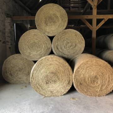
Pferdeheu 1.Schnitt Juli 2025/Rundballen 1.50m
Cavertitz
LWB Streubel
@Landwirtschaftsbetr.-Streubel
Heu
Lieferant entlädt
Rundballen
Bio
Regenfrei
3 weitere...
B+

Haferstroh 1.50m Ernte 25 Ausgezeichnete Qualität
Cavertitz
LWB Streubel
@Landwirtschaftsbetr.-Streubel
Stroh
Lieferant entlädt
Rundballen
Regenfrei
3 weitere...
B+
Deprecated: Creation of dynamic property Zend_View_Helper_Ads::$adLink is deprecated in /var/www/stall-frei/htdocs/staging.stall-frei.de/library/Psf/View/Helper/Ads.php on line 108

Futtersack HeuToy, Fressbremse in pink
Mechtersen
STALL-FREIde Marketing
@STALL-FREI-Marketing
Stundenlange Beschäftigung die
Koliken vorbeugt, geringe Staubinhalation mit
steuerbarer Futterentnahme


Futtermittel & Einstreu mit Lieferung!
Schwaara
MK-Agrarprodukte
@MK-Agrarprodukte
Heu
Empfänger lädt ab
Großballen
Regenfrei
2 weitere...
P+

Heu und Stroh /Rundballen/Quaderballen
Sandersdorf
jule13
@Jule2024
Stroh
Lieferant entlädt
Rundballen
Regenfrei
3 weitere...
B+
Leider kein Vorschaubild
Leider kein Vorschaubild
BIO-Heu, 1. Schnitt 2025, Quaderballen (60x40x30)
Tirpersdorf
Forstbaumschule
@Forstbaumschule
Heu
Kleinballen/HD-Ballen
Bio
Regenfrei
Wird verladen
1 weitere...
B+
Leider kein Vorschaubild
Leider kein Vorschaubild
BIO-Heu, 1. Schnitt 2024, Quaderballen (60x40x30)
Tirpersdorf
Forstbaumschule
@Forstbaumschule
Heu
Kleinballen/HD-Ballen
Bio
Regenfrei
Käufer lädt selbst
1 weitere...
aktuell
B+
Leider kein Vorschaubild
Leider kein Vorschaubild
Bio-Heu, 1. Schnitt aus 2024 (BIOLAND) zu verkauf.
Tirpersdorf
Forstbaumschule
@Forstbaumschule
Heu
Empfänger lädt ab
Großballen
Bio
Regenfrei
2 weitere...
B+

Luzerneheu 1.Schnitt
Teutschenthal
Nancy
@Haltergemeinschaft-TT
Heu
Empfänger lädt ab
Rundballen
Regenfrei
2 weitere...
B+

Das Beste für die Hufe
Mechtersen
STALL-FREIde Marketing
@STALL-FREI-Marketing
Hufschmiede und Hufpfleger in Ihrer Nähe
Leider kein Vorschaubild
Leider kein Vorschaubild
Heu zu verkaufen
Kremmen OT Staffelde
Rhinland Reitpark GmbH
@Rhinland-Reitpark
Heu
Empfänger lädt ab
Rundballen
Regenfrei
3 weitere...
B+

Haferstroh in Futterqualität für gesunde Pferde ...
Schollene
Guthof Mühlenfels
@Gutshof-Muehlenfels
Einstreu
Lieferant entlädt
Großballen
Regenfrei
3 weitere...
B+
Deprecated: Creation of dynamic property Zend_View::$pageCount is deprecated in /var/www/stall-frei/htdocs/staging.stall-frei.de/library/vendor/shardj/zf1-future/library/Zend/View/Abstract.php on line 308
Deprecated: Creation of dynamic property Zend_View::$itemCountPerPage is deprecated in /var/www/stall-frei/htdocs/staging.stall-frei.de/library/vendor/shardj/zf1-future/library/Zend/View/Abstract.php on line 308
Deprecated: Creation of dynamic property Zend_View::$first is deprecated in /var/www/stall-frei/htdocs/staging.stall-frei.de/library/vendor/shardj/zf1-future/library/Zend/View/Abstract.php on line 308
Deprecated: Creation of dynamic property Zend_View::$current is deprecated in /var/www/stall-frei/htdocs/staging.stall-frei.de/library/vendor/shardj/zf1-future/library/Zend/View/Abstract.php on line 308
Deprecated: Creation of dynamic property Zend_View::$last is deprecated in /var/www/stall-frei/htdocs/staging.stall-frei.de/library/vendor/shardj/zf1-future/library/Zend/View/Abstract.php on line 308
Deprecated: Creation of dynamic property Zend_View::$next is deprecated in /var/www/stall-frei/htdocs/staging.stall-frei.de/library/vendor/shardj/zf1-future/library/Zend/View/Abstract.php on line 308
Deprecated: Creation of dynamic property Zend_View::$pagesInRange is deprecated in /var/www/stall-frei/htdocs/staging.stall-frei.de/library/vendor/shardj/zf1-future/library/Zend/View/Abstract.php on line 308
Deprecated: Creation of dynamic property Zend_View::$firstPageInRange is deprecated in /var/www/stall-frei/htdocs/staging.stall-frei.de/library/vendor/shardj/zf1-future/library/Zend/View/Abstract.php on line 308
Deprecated: Creation of dynamic property Zend_View::$lastPageInRange is deprecated in /var/www/stall-frei/htdocs/staging.stall-frei.de/library/vendor/shardj/zf1-future/library/Zend/View/Abstract.php on line 308
Deprecated: Creation of dynamic property Zend_View::$currentItemCount is deprecated in /var/www/stall-frei/htdocs/staging.stall-frei.de/library/vendor/shardj/zf1-future/library/Zend/View/Abstract.php on line 308
Deprecated: Creation of dynamic property Zend_View::$totalItemCount is deprecated in /var/www/stall-frei/htdocs/staging.stall-frei.de/library/vendor/shardj/zf1-future/library/Zend/View/Abstract.php on line 308
Deprecated: Creation of dynamic property Zend_View::$firstItemNumber is deprecated in /var/www/stall-frei/htdocs/staging.stall-frei.de/library/vendor/shardj/zf1-future/library/Zend/View/Abstract.php on line 308
Deprecated: Creation of dynamic property Zend_View::$lastItemNumber is deprecated in /var/www/stall-frei/htdocs/staging.stall-frei.de/library/vendor/shardj/zf1-future/library/Zend/View/Abstract.php on line 308
Deprecated: Creation of dynamic property Zend_View::$router is deprecated in /var/www/stall-frei/htdocs/staging.stall-frei.de/library/vendor/shardj/zf1-future/library/Zend/View/Abstract.php on line 308
Deprecated: Creation of dynamic property Zend_View::$urlParams is deprecated in /var/www/stall-frei/htdocs/staging.stall-frei.de/library/vendor/shardj/zf1-future/library/Zend/View/Abstract.php on line 308
Deprecated: Creation of dynamic property Zend_View::$showAds is deprecated in /var/www/stall-frei/htdocs/staging.stall-frei.de/library/vendor/shardj/zf1-future/library/Zend/View/Abstract.php on line 308
Deprecated: Creation of dynamic property Zend_View::$objectIds is deprecated in /var/www/stall-frei/htdocs/staging.stall-frei.de/library/vendor/shardj/zf1-future/library/Zend/View/Abstract.php on line 308
Deprecated: Creation of dynamic property Zend_View::$showNavbar is deprecated in /var/www/stall-frei/htdocs/staging.stall-frei.de/library/vendor/shardj/zf1-future/library/Zend/View/Abstract.php on line 308
Deprecated: Creation of dynamic property Zend_View::$showBreadcrumb is deprecated in /var/www/stall-frei/htdocs/staging.stall-frei.de/library/vendor/shardj/zf1-future/library/Zend/View/Abstract.php on line 308
Deprecated: Creation of dynamic property Zend_View::$showFooter is deprecated in /var/www/stall-frei/htdocs/staging.stall-frei.de/library/vendor/shardj/zf1-future/library/Zend/View/Abstract.php on line 308
Deprecated: Creation of dynamic property Zend_View::$showInternalAds is deprecated in /var/www/stall-frei/htdocs/staging.stall-frei.de/library/vendor/shardj/zf1-future/library/Zend/View/Abstract.php on line 308
Deprecated: Creation of dynamic property Zend_View::$blNoContent is deprecated in /var/www/stall-frei/htdocs/staging.stall-frei.de/library/vendor/shardj/zf1-future/library/Zend/View/Abstract.php on line 308
Deprecated: Creation of dynamic property Zend_View::$sMetaDesc is deprecated in /var/www/stall-frei/htdocs/staging.stall-frei.de/library/vendor/shardj/zf1-future/library/Zend/View/Abstract.php on line 308
Deprecated: Creation of dynamic property Zend_View::$useGmaps is deprecated in /var/www/stall-frei/htdocs/staging.stall-frei.de/library/vendor/shardj/zf1-future/library/Zend/View/Abstract.php on line 308
Deprecated: Creation of dynamic property Zend_View::$touches is deprecated in /var/www/stall-frei/htdocs/staging.stall-frei.de/library/vendor/shardj/zf1-future/library/Zend/View/Abstract.php on line 308
Deprecated: Creation of dynamic property Zend_View::$oProject is deprecated in /var/www/stall-frei/htdocs/staging.stall-frei.de/library/vendor/shardj/zf1-future/library/Zend/View/Abstract.php on line 308
Deprecated: Creation of dynamic property Zend_View::$pageHeadline is deprecated in /var/www/stall-frei/htdocs/staging.stall-frei.de/library/vendor/shardj/zf1-future/library/Zend/View/Abstract.php on line 308
Deprecated: Creation of dynamic property Zend_View::$disableLocationField is deprecated in /var/www/stall-frei/htdocs/staging.stall-frei.de/library/vendor/shardj/zf1-future/library/Zend/View/Abstract.php on line 308
Deprecated: Creation of dynamic property Zend_View::$isSearch is deprecated in /var/www/stall-frei/htdocs/staging.stall-frei.de/library/vendor/shardj/zf1-future/library/Zend/View/Abstract.php on line 308
Deprecated: Creation of dynamic property Zend_View::$pageTitle is deprecated in /var/www/stall-frei/htdocs/staging.stall-frei.de/library/vendor/shardj/zf1-future/library/Zend/View/Abstract.php on line 308
Deprecated: Creation of dynamic property Psf_Form_Element_Text::$class is deprecated in /var/www/stall-frei/htdocs/staging.stall-frei.de/library/vendor/shardj/zf1-future/library/Zend/Form/Element.php on line 874
Deprecated: Creation of dynamic property Psf_Form_Element_Text::$size is deprecated in /var/www/stall-frei/htdocs/staging.stall-frei.de/library/vendor/shardj/zf1-future/library/Zend/Form/Element.php on line 874
Deprecated: Creation of dynamic property Psf_Form_Element_Text::$placeholder is deprecated in /var/www/stall-frei/htdocs/staging.stall-frei.de/library/vendor/shardj/zf1-future/library/Zend/Form/Element.php on line 874
Deprecated: Creation of dynamic property Psf_Form_Element_Hidden::$class is deprecated in /var/www/stall-frei/htdocs/staging.stall-frei.de/library/vendor/shardj/zf1-future/library/Zend/Form/Element.php on line 874
Deprecated: Creation of dynamic property Psf_Form_Element_Hidden::$class is deprecated in /var/www/stall-frei/htdocs/staging.stall-frei.de/library/vendor/shardj/zf1-future/library/Zend/Form/Element.php on line 874
Deprecated: Creation of dynamic property Psf_Form_Element_Hidden::$class is deprecated in /var/www/stall-frei/htdocs/staging.stall-frei.de/library/vendor/shardj/zf1-future/library/Zend/Form/Element.php on line 874
Deprecated: Creation of dynamic property Psf_Form_Element_Hidden::$class is deprecated in /var/www/stall-frei/htdocs/staging.stall-frei.de/library/vendor/shardj/zf1-future/library/Zend/Form/Element.php on line 874
Deprecated: Creation of dynamic property Psf_Form_Element_Select::$class is deprecated in /var/www/stall-frei/htdocs/staging.stall-frei.de/library/vendor/shardj/zf1-future/library/Zend/Form/Element.php on line 874
Deprecated: Creation of dynamic property Psf_Form_Element_Select::$class is deprecated in /var/www/stall-frei/htdocs/staging.stall-frei.de/library/vendor/shardj/zf1-future/library/Zend/Form/Element.php on line 874
Deprecated: Creation of dynamic property Psf_Form_Element_Select::$class is deprecated in /var/www/stall-frei/htdocs/staging.stall-frei.de/library/vendor/shardj/zf1-future/library/Zend/Form/Element.php on line 874
Deprecated: Creation of dynamic property Psf_Form_Element_Select::$class is deprecated in /var/www/stall-frei/htdocs/staging.stall-frei.de/library/vendor/shardj/zf1-future/library/Zend/Form/Element.php on line 874
Deprecated: Creation of dynamic property Zend_View::$sort is deprecated in /var/www/stall-frei/htdocs/staging.stall-frei.de/library/vendor/shardj/zf1-future/library/Zend/View/Abstract.php on line 308
Deprecated: Creation of dynamic property Zend_View::$searchLocation is deprecated in /var/www/stall-frei/htdocs/staging.stall-frei.de/library/vendor/shardj/zf1-future/library/Zend/View/Abstract.php on line 308
Deprecated: Creation of dynamic property Zend_View::$locationHint is deprecated in /var/www/stall-frei/htdocs/staging.stall-frei.de/library/vendor/shardj/zf1-future/library/Zend/View/Abstract.php on line 308
Psf_GeoCoder_Abstract::getLocation: Cunnersdorf Get Location CachedOrLive
Psf_GeoCoder_Abstract::getCachedOrLive: Cunnersdorf
Psf_GeoCoder_OpenCageData::makeApiRequest: response:
Array
(
[documentation] => https://opencagedata.com/api
[licenses] => Array
(
[0] => Array
(
[name] => see attribution guide
[url] => https://opencagedata.com/credits
)
)
[results] => Array
(
[0] => Array
(
[bounds] => Array
(
[northeast] => Array
(
[lat] => 51.0634199
[lng] => 13.8979892
)
[southwest] => Array
(
[lat] => 51.0234199
[lng] => 13.8579892
)
)
[components] => Array
(
[ISO_3166-1_alpha-2] => DE
[ISO_3166-1_alpha-3] => DEU
[ISO_3166-2] => Array
(
[0] => DE-SN
)
[_category] => place
[_normalized_city] => Dresden
[_type] => neighbourhood
[city] => Dresden
[city_district] => Schönfeld-Weißig
[continent] => Europe
[country] => Deutschland
[country_code] => de
[political_union] => European Union
[postcode] => 01328
[state] => Sachsen
[state_code] => SN
[suburb] => Cunnersdorf
)
[confidence] => 7
[formatted] => 01328 Dresden, Deutschland
[geometry] => Array
(
[lat] => 51.0434199
[lng] => 13.8779892
)
)
[1] => Array
(
[bounds] => Array
(
[northeast] => Array
(
[lat] => 50.9054041
[lng] => 14.1377262
)
[southwest] => Array
(
[lat] => 50.8654041
[lng] => 14.0977262
)
)
[components] => Array
(
[ISO_3166-1_alpha-2] => DE
[ISO_3166-1_alpha-3] => DEU
[ISO_3166-2] => Array
(
[0] => DE-SN
)
[_category] => place
[_normalized_city] => Gohrisch
[_type] => village
[city] => Gohrisch
[continent] => Europe
[country] => Deutschland
[country_code] => de
[county] => Sächsische Schweiz-Osterzgebirge
[municipality] => Königstein/Sächs. Schw.
[political_union] => European Union
[postcode] => 01824
[state] => Sachsen
[state_code] => SN
[village] => Cunnersdorf
)
[confidence] => 7
[formatted] => 01824 Cunnersdorf, Deutschland
[geometry] => Array
(
[lat] => 50.8854041
[lng] => 14.1177262
)
)
[2] => Array
(
[bounds] => Array
(
[northeast] => Array
(
[lat] => 51.3339582
[lng] => 14.0766128
)
[southwest] => Array
(
[lat] => 51.2939582
[lng] => 14.0366128
)
)
[components] => Array
(
[ISO_3166-1_alpha-2] => DE
[ISO_3166-1_alpha-3] => DEU
[ISO_3166-2] => Array
(
[0] => DE-SN
)
[_category] => place
[_normalized_city] => Kamenz
[_type] => village
[continent] => Europe
[country] => Deutschland
[country_code] => de
[county] => Bautzen
[political_union] => European Union
[state] => Sachsen
[state_code] => SN
[town] => Kamenz
[village] => Cunnersdorf
)
[confidence] => 7
[formatted] => Cunnersdorf, Sachsen, Deutschland
[geometry] => Array
(
[lat] => 51.3139582
[lng] => 14.0566128
)
)
[3] => Array
(
[bounds] => Array
(
[northeast] => Array
(
[lat] => 50.8956577
[lng] => 13.8006915
)
[southwest] => Array
(
[lat] => 50.8556577
[lng] => 13.7606915
)
)
[components] => Array
(
[ISO_3166-1_alpha-2] => DE
[ISO_3166-1_alpha-3] => DEU
[ISO_3166-2] => Array
(
[0] => DE-SN
)
[_category] => place
[_normalized_city] => Glashütte
[_type] => village
[continent] => Europe
[country] => Deutschland
[country_code] => de
[county] => Sächsische Schweiz-Osterzgebirge
[political_union] => European Union
[postcode] => 01768
[state] => Sachsen
[state_code] => SN
[town] => Glashütte
[village] => Cunnersdorf
)
[confidence] => 7
[formatted] => 01768 Cunnersdorf, Deutschland
[geometry] => Array
(
[lat] => 50.8756577
[lng] => 13.7806915
)
)
[4] => Array
(
[bounds] => Array
(
[northeast] => Array
(
[lat] => 50.9796832
[lng] => 13.9820218
)
[southwest] => Array
(
[lat] => 50.9396832
[lng] => 13.9420218
)
)
[components] => Array
(
[ISO_3166-1_alpha-2] => DE
[ISO_3166-1_alpha-3] => DEU
[ISO_3166-2] => Array
(
[0] => DE-SN
)
[_category] => place
[_normalized_city] => Pirna
[_type] => neighbourhood
[continent] => Europe
[country] => Deutschland
[country_code] => de
[county] => Sächsische Schweiz-Osterzgebirge
[municipality] => Pirna
[political_union] => European Union
[postcode] => 01796
[state] => Sachsen
[state_code] => SN
[suburb] => Cunnersdorf
[town] => Pirna
)
[confidence] => 7
[formatted] => 01796 Pirna, Deutschland
[geometry] => Array
(
[lat] => 50.9596832
[lng] => 13.9620218
)
)
[5] => Array
(
[bounds] => Array
(
[northeast] => Array
(
[lat] => 51.0216427
[lng] => 13.7252921
)
[southwest] => Array
(
[lat] => 50.9816427
[lng] => 13.6852921
)
)
[components] => Array
(
[ISO_3166-1_alpha-2] => DE
[ISO_3166-1_alpha-3] => DEU
[ISO_3166-2] => Array
(
[0] => DE-SN
)
[_category] => place
[_normalized_city] => Bannewitz
[_type] => village
[city] => Bannewitz
[continent] => Europe
[country] => Deutschland
[country_code] => de
[county] => Sächsische Schweiz-Osterzgebirge
[political_union] => European Union
[postcode] => 01189
[state] => Sachsen
[state_code] => SN
[village] => Cunnersdorf
)
[confidence] => 7
[formatted] => 01189 Cunnersdorf, Deutschland
[geometry] => Array
(
[lat] => 51.0016427
[lng] => 13.7052921
)
)
[6] => Array
(
[bounds] => Array
(
[northeast] => Array
(
[lat] => 50.9751152
[lng] => 13.1618988
)
[southwest] => Array
(
[lat] => 50.9351152
[lng] => 13.1218988
)
)
[components] => Array
(
[ISO_3166-1_alpha-2] => DE
[ISO_3166-1_alpha-3] => DEU
[ISO_3166-2] => Array
(
[0] => DE-SN
)
[_category] => place
[_normalized_city] => Hainichen
[_type] => village
[continent] => Europe
[country] => Deutschland
[country_code] => de
[county] => Mittelsachsen
[municipality] => Lichtenau
[political_union] => European Union
[postcode] => 09661
[state] => Sachsen
[state_code] => SN
[town] => Hainichen
[village] => Cunnersdorf
)
[confidence] => 7
[formatted] => 09661 Cunnersdorf, Deutschland
[geometry] => Array
(
[lat] => 50.9551152
[lng] => 13.1418988
)
)
[7] => Array
(
[bounds] => Array
(
[northeast] => Array
(
[lat] => 51.2937796
[lng] => 13.6884207
)
[southwest] => Array
(
[lat] => 51.2537796
[lng] => 13.6484207
)
)
[components] => Array
(
[ISO_3166-1_alpha-2] => DE
[ISO_3166-1_alpha-3] => DEU
[ISO_3166-2] => Array
(
[0] => DE-SN
)
[_category] => place
[_normalized_city] => Ebersbach
[_type] => village
[city] => Ebersbach
[continent] => Europe
[country] => Deutschland
[country_code] => de
[county] => Meißen
[political_union] => European Union
[postcode] => 01561
[state] => Sachsen
[state_code] => SN
[village] => Cunnersdorf
)
[confidence] => 7
[formatted] => 01561 Cunnersdorf, Deutschland
[geometry] => Array
(
[lat] => 51.2737796
[lng] => 13.6684207
)
)
[8] => Array
(
[bounds] => Array
(
[northeast] => Array
(
[lat] => 51.3858696
[lng] => 12.5820728
)
[southwest] => Array
(
[lat] => 51.3458696
[lng] => 12.5420728
)
)
[components] => Array
(
[ISO_3166-1_alpha-2] => DE
[ISO_3166-1_alpha-3] => DEU
[ISO_3166-2] => Array
(
[0] => DE-SN
)
[_category] => place
[_normalized_city] => Borsdorf
[_type] => hamlet
[continent] => Europe
[country] => Deutschland
[country_code] => de
[county] => Landkreis Leipzig
[hamlet] => Cunnersdorf
[political_union] => European Union
[postcode] => 04451
[state] => Sachsen
[state_code] => SN
[village] => Borsdorf
)
[confidence] => 7
[formatted] => Cunnersdorf, 04451 Borsdorf, Deutschland
[geometry] => Array
(
[lat] => 51.3658696
[lng] => 12.5620728
)
)
[9] => Array
(
[bounds] => Array
(
[northeast] => Array
(
[lat] => 51.2038298
[lng] => 13.8281959
)
[southwest] => Array
(
[lat] => 51.1638298
[lng] => 13.7881959
)
)
[components] => Array
(
[ISO_3166-1_alpha-2] => DE
[ISO_3166-1_alpha-3] => DEU
[ISO_3166-2] => Array
(
[0] => DE-SN
)
[_category] => place
[_normalized_city] => Ottendorf-Okrilla
[_type] => neighbourhood
[continent] => Europe
[country] => Deutschland
[country_code] => de
[county] => Bautzen
[political_union] => European Union
[postcode] => 01458
[state] => Sachsen
[state_code] => SN
[suburb] => Cunnersdorf
[town] => Ottendorf-Okrilla
)
[confidence] => 7
[formatted] => 01458 Ottendorf-Okrilla, Deutschland
[geometry] => Array
(
[lat] => 51.1838298
[lng] => 13.8081959
)
)
)
[status] => Array
(
[code] => 200
[message] => OK
)
[stay_informed] => Array
(
[blog] => https://blog.opencagedata.com
[mastodon] => https://en.osm.town/@opencage
)
[thanks] => For using an OpenCage API
[timestamp] => Array
(
[created_http] => Sat, 07 Feb 2026 07:32:55 GMT
[created_unix] => 1770449575
)
[total_results] => 10
)
Psf_GeoCoder_Abstract::convertLocationResult
{"documentation":"https:\/\/opencagedata.com\/api","licenses":[{"name":"see attribution guide","url":"https:\/\/opencagedata.com\/credits"}],"results":[{"bounds":{"northeast":{"lat":51.0634199,"lng":13.8979892},"southwest":{"lat":51.0234199,"lng":13.8579892}},"components":{"ISO_3166-1_alpha-2":"DE","ISO_3166-1_alpha-3":"DEU","ISO_3166-2":["DE-SN"],"_category":"place","_normalized_city":"Dresden","_type":"neighbourhood","city":"Dresden","city_district":"Sch\u00f6nfeld-Wei\u00dfig","continent":"Europe","country":"Deutschland","country_code":"de","political_union":"European Union","postcode":"01328","state":"Sachsen","state_code":"SN","suburb":"Cunnersdorf"},"confidence":7,"formatted":"01328 Dresden, Deutschland","geometry":{"lat":51.0434199,"lng":13.8779892}},{"bounds":{"northeast":{"lat":50.9054041,"lng":14.1377262},"southwest":{"lat":50.8654041,"lng":14.0977262}},"components":{"ISO_3166-1_alpha-2":"DE","ISO_3166-1_alpha-3":"DEU","ISO_3166-2":["DE-SN"],"_category":"place","_normalized_city":"Gohrisch","_type":"village","city":"Gohrisch","continent":"Europe","country":"Deutschland","country_code":"de","county":"S\u00e4chsische Schweiz-Osterzgebirge","municipality":"K\u00f6nigstein\/S\u00e4chs. Schw.","political_union":"European Union","postcode":"01824","state":"Sachsen","state_code":"SN","village":"Cunnersdorf"},"confidence":7,"formatted":"01824 Cunnersdorf, Deutschland","geometry":{"lat":50.8854041,"lng":14.1177262}},{"bounds":{"northeast":{"lat":51.3339582,"lng":14.0766128},"southwest":{"lat":51.2939582,"lng":14.0366128}},"components":{"ISO_3166-1_alpha-2":"DE","ISO_3166-1_alpha-3":"DEU","ISO_3166-2":["DE-SN"],"_category":"place","_normalized_city":"Kamenz","_type":"village","continent":"Europe","country":"Deutschland","country_code":"de","county":"Bautzen","political_union":"European Union","state":"Sachsen","state_code":"SN","town":"Kamenz","village":"Cunnersdorf"},"confidence":7,"formatted":"Cunnersdorf, Sachsen, Deutschland","geometry":{"lat":51.3139582,"lng":14.0566128}},{"bounds":{"northeast":{"lat":50.8956577,"lng":13.8006915},"southwest":{"lat":50.8556577,"lng":13.7606915}},"components":{"ISO_3166-1_alpha-2":"DE","ISO_3166-1_alpha-3":"DEU","ISO_3166-2":["DE-SN"],"_category":"place","_normalized_city":"Glash\u00fctte","_type":"village","continent":"Europe","country":"Deutschland","country_code":"de","county":"S\u00e4chsische Schweiz-Osterzgebirge","political_union":"European Union","postcode":"01768","state":"Sachsen","state_code":"SN","town":"Glash\u00fctte","village":"Cunnersdorf"},"confidence":7,"formatted":"01768 Cunnersdorf, Deutschland","geometry":{"lat":50.8756577,"lng":13.7806915}},{"bounds":{"northeast":{"lat":50.9796832,"lng":13.9820218},"southwest":{"lat":50.9396832,"lng":13.9420218}},"components":{"ISO_3166-1_alpha-2":"DE","ISO_3166-1_alpha-3":"DEU","ISO_3166-2":["DE-SN"],"_category":"place","_normalized_city":"Pirna","_type":"neighbourhood","continent":"Europe","country":"Deutschland","country_code":"de","county":"S\u00e4chsische Schweiz-Osterzgebirge","municipality":"Pirna","political_union":"European Union","postcode":"01796","state":"Sachsen","state_code":"SN","suburb":"Cunnersdorf","town":"Pirna"},"confidence":7,"formatted":"01796 Pirna, Deutschland","geometry":{"lat":50.9596832,"lng":13.9620218}},{"bounds":{"northeast":{"lat":51.0216427,"lng":13.7252921},"southwest":{"lat":50.9816427,"lng":13.6852921}},"components":{"ISO_3166-1_alpha-2":"DE","ISO_3166-1_alpha-3":"DEU","ISO_3166-2":["DE-SN"],"_category":"place","_normalized_city":"Bannewitz","_type":"village","city":"Bannewitz","continent":"Europe","country":"Deutschland","country_code":"de","county":"S\u00e4chsische Schweiz-Osterzgebirge","political_union":"European Union","postcode":"01189","state":"Sachsen","state_code":"SN","village":"Cunnersdorf"},"confidence":7,"formatted":"01189 Cunnersdorf, Deutschland","geometry":{"lat":51.0016427,"lng":13.7052921}},{"bounds":{"northeast":{"lat":50.9751152,"lng":13.1618988},"southwest":{"lat":50.9351152,"lng":13.1218988}},"components":{"ISO_3166-1_alpha-2":"DE","ISO_3166-1_alpha-3":"DEU","ISO_3166-2":["DE-SN"],"_category":"place","_normalized_city":"Hainichen","_type":"village","continent":"Europe","country":"Deutschland","country_code":"de","county":"Mittelsachsen","municipality":"Lichtenau","political_union":"European Union","postcode":"09661","state":"Sachsen","state_code":"SN","town":"Hainichen","village":"Cunnersdorf"},"confidence":7,"formatted":"09661 Cunnersdorf, Deutschland","geometry":{"lat":50.9551152,"lng":13.1418988}},{"bounds":{"northeast":{"lat":51.2937796,"lng":13.6884207},"southwest":{"lat":51.2537796,"lng":13.6484207}},"components":{"ISO_3166-1_alpha-2":"DE","ISO_3166-1_alpha-3":"DEU","ISO_3166-2":["DE-SN"],"_category":"place","_normalized_city":"Ebersbach","_type":"village","city":"Ebersbach","continent":"Europe","country":"Deutschland","country_code":"de","county":"Mei\u00dfen","political_union":"European Union","postcode":"01561","state":"Sachsen","state_code":"SN","village":"Cunnersdorf"},"confidence":7,"formatted":"01561 Cunnersdorf, Deutschland","geometry":{"lat":51.2737796,"lng":13.6684207}},{"bounds":{"northeast":{"lat":51.3858696,"lng":12.5820728},"southwest":{"lat":51.3458696,"lng":12.5420728}},"components":{"ISO_3166-1_alpha-2":"DE","ISO_3166-1_alpha-3":"DEU","ISO_3166-2":["DE-SN"],"_category":"place","_normalized_city":"Borsdorf","_type":"hamlet","continent":"Europe","country":"Deutschland","country_code":"de","county":"Landkreis Leipzig","hamlet":"Cunnersdorf","political_union":"European Union","postcode":"04451","state":"Sachsen","state_code":"SN","village":"Borsdorf"},"confidence":7,"formatted":"Cunnersdorf, 04451 Borsdorf, Deutschland","geometry":{"lat":51.3658696,"lng":12.5620728}},{"bounds":{"northeast":{"lat":51.2038298,"lng":13.8281959},"southwest":{"lat":51.1638298,"lng":13.7881959}},"components":{"ISO_3166-1_alpha-2":"DE","ISO_3166-1_alpha-3":"DEU","ISO_3166-2":["DE-SN"],"_category":"place","_normalized_city":"Ottendorf-Okrilla","_type":"neighbourhood","continent":"Europe","country":"Deutschland","country_code":"de","county":"Bautzen","political_union":"European Union","postcode":"01458","state":"Sachsen","state_code":"SN","suburb":"Cunnersdorf","town":"Ottendorf-Okrilla"},"confidence":7,"formatted":"01458 Ottendorf-Okrilla, Deutschland","geometry":{"lat":51.1838298,"lng":13.8081959}}],"status":{"code":200,"message":"OK"},"stay_informed":{"blog":"https:\/\/blog.opencagedata.com","mastodon":"https:\/\/en.osm.town\/@opencage"},"thanks":"For using an OpenCage API","timestamp":{"created_http":"Sat, 07 Feb 2026 07:32:55 GMT","created_unix":1770449575},"total_results":10}Array
(
[0] => stdClass Object
(
[bounds] => stdClass Object
(
[northeast] => stdClass Object
(
[lat] => 51.0634199
[lng] => 13.8979892
)
[southwest] => stdClass Object
(
[lat] => 51.0234199
[lng] => 13.8579892
)
)
[components] => stdClass Object
(
[ISO_3166-1_alpha-2] => DE
[ISO_3166-1_alpha-3] => DEU
[ISO_3166-2] => Array
(
[0] => DE-SN
)
[_category] => place
[_normalized_city] => Dresden
[_type] => neighbourhood
[city] => Dresden
[city_district] => Schönfeld-Weißig
[continent] => Europe
[country] => Deutschland
[country_code] => de
[political_union] => European Union
[postcode] => 01328
[state] => Sachsen
[state_code] => SN
[suburb] => Cunnersdorf
)
[confidence] => 7
[formatted] => 01328 Dresden, Deutschland
[geometry] => stdClass Object
(
[lat] => 51.0434199
[lng] => 13.8779892
)
)
[1] => stdClass Object
(
[bounds] => stdClass Object
(
[northeast] => stdClass Object
(
[lat] => 50.9054041
[lng] => 14.1377262
)
[southwest] => stdClass Object
(
[lat] => 50.8654041
[lng] => 14.0977262
)
)
[components] => stdClass Object
(
[ISO_3166-1_alpha-2] => DE
[ISO_3166-1_alpha-3] => DEU
[ISO_3166-2] => Array
(
[0] => DE-SN
)
[_category] => place
[_normalized_city] => Gohrisch
[_type] => village
[city] => Gohrisch
[continent] => Europe
[country] => Deutschland
[country_code] => de
[county] => Sächsische Schweiz-Osterzgebirge
[municipality] => Königstein/Sächs. Schw.
[political_union] => European Union
[postcode] => 01824
[state] => Sachsen
[state_code] => SN
[village] => Cunnersdorf
)
[confidence] => 7
[formatted] => 01824 Cunnersdorf, Deutschland
[geometry] => stdClass Object
(
[lat] => 50.8854041
[lng] => 14.1177262
)
)
[2] => stdClass Object
(
[bounds] => stdClass Object
(
[northeast] => stdClass Object
(
[lat] => 51.3339582
[lng] => 14.0766128
)
[southwest] => stdClass Object
(
[lat] => 51.2939582
[lng] => 14.0366128
)
)
[components] => stdClass Object
(
[ISO_3166-1_alpha-2] => DE
[ISO_3166-1_alpha-3] => DEU
[ISO_3166-2] => Array
(
[0] => DE-SN
)
[_category] => place
[_normalized_city] => Kamenz
[_type] => village
[continent] => Europe
[country] => Deutschland
[country_code] => de
[county] => Bautzen
[political_union] => European Union
[state] => Sachsen
[state_code] => SN
[town] => Kamenz
[village] => Cunnersdorf
)
[confidence] => 7
[formatted] => Cunnersdorf, Sachsen, Deutschland
[geometry] => stdClass Object
(
[lat] => 51.3139582
[lng] => 14.0566128
)
)
[3] => stdClass Object
(
[bounds] => stdClass Object
(
[northeast] => stdClass Object
(
[lat] => 50.8956577
[lng] => 13.8006915
)
[southwest] => stdClass Object
(
[lat] => 50.8556577
[lng] => 13.7606915
)
)
[components] => stdClass Object
(
[ISO_3166-1_alpha-2] => DE
[ISO_3166-1_alpha-3] => DEU
[ISO_3166-2] => Array
(
[0] => DE-SN
)
[_category] => place
[_normalized_city] => Glashütte
[_type] => village
[continent] => Europe
[country] => Deutschland
[country_code] => de
[county] => Sächsische Schweiz-Osterzgebirge
[political_union] => European Union
[postcode] => 01768
[state] => Sachsen
[state_code] => SN
[town] => Glashütte
[village] => Cunnersdorf
)
[confidence] => 7
[formatted] => 01768 Cunnersdorf, Deutschland
[geometry] => stdClass Object
(
[lat] => 50.8756577
[lng] => 13.7806915
)
)
[4] => stdClass Object
(
[bounds] => stdClass Object
(
[northeast] => stdClass Object
(
[lat] => 50.9796832
[lng] => 13.9820218
)
[southwest] => stdClass Object
(
[lat] => 50.9396832
[lng] => 13.9420218
)
)
[components] => stdClass Object
(
[ISO_3166-1_alpha-2] => DE
[ISO_3166-1_alpha-3] => DEU
[ISO_3166-2] => Array
(
[0] => DE-SN
)
[_category] => place
[_normalized_city] => Pirna
[_type] => neighbourhood
[continent] => Europe
[country] => Deutschland
[country_code] => de
[county] => Sächsische Schweiz-Osterzgebirge
[municipality] => Pirna
[political_union] => European Union
[postcode] => 01796
[state] => Sachsen
[state_code] => SN
[suburb] => Cunnersdorf
[town] => Pirna
)
[confidence] => 7
[formatted] => 01796 Pirna, Deutschland
[geometry] => stdClass Object
(
[lat] => 50.9596832
[lng] => 13.9620218
)
)
[5] => stdClass Object
(
[bounds] => stdClass Object
(
[northeast] => stdClass Object
(
[lat] => 51.0216427
[lng] => 13.7252921
)
[southwest] => stdClass Object
(
[lat] => 50.9816427
[lng] => 13.6852921
)
)
[components] => stdClass Object
(
[ISO_3166-1_alpha-2] => DE
[ISO_3166-1_alpha-3] => DEU
[ISO_3166-2] => Array
(
[0] => DE-SN
)
[_category] => place
[_normalized_city] => Bannewitz
[_type] => village
[city] => Bannewitz
[continent] => Europe
[country] => Deutschland
[country_code] => de
[county] => Sächsische Schweiz-Osterzgebirge
[political_union] => European Union
[postcode] => 01189
[state] => Sachsen
[state_code] => SN
[village] => Cunnersdorf
)
[confidence] => 7
[formatted] => 01189 Cunnersdorf, Deutschland
[geometry] => stdClass Object
(
[lat] => 51.0016427
[lng] => 13.7052921
)
)
[6] => stdClass Object
(
[bounds] => stdClass Object
(
[northeast] => stdClass Object
(
[lat] => 50.9751152
[lng] => 13.1618988
)
[southwest] => stdClass Object
(
[lat] => 50.9351152
[lng] => 13.1218988
)
)
[components] => stdClass Object
(
[ISO_3166-1_alpha-2] => DE
[ISO_3166-1_alpha-3] => DEU
[ISO_3166-2] => Array
(
[0] => DE-SN
)
[_category] => place
[_normalized_city] => Hainichen
[_type] => village
[continent] => Europe
[country] => Deutschland
[country_code] => de
[county] => Mittelsachsen
[municipality] => Lichtenau
[political_union] => European Union
[postcode] => 09661
[state] => Sachsen
[state_code] => SN
[town] => Hainichen
[village] => Cunnersdorf
)
[confidence] => 7
[formatted] => 09661 Cunnersdorf, Deutschland
[geometry] => stdClass Object
(
[lat] => 50.9551152
[lng] => 13.1418988
)
)
[7] => stdClass Object
(
[bounds] => stdClass Object
(
[northeast] => stdClass Object
(
[lat] => 51.2937796
[lng] => 13.6884207
)
[southwest] => stdClass Object
(
[lat] => 51.2537796
[lng] => 13.6484207
)
)
[components] => stdClass Object
(
[ISO_3166-1_alpha-2] => DE
[ISO_3166-1_alpha-3] => DEU
[ISO_3166-2] => Array
(
[0] => DE-SN
)
[_category] => place
[_normalized_city] => Ebersbach
[_type] => village
[city] => Ebersbach
[continent] => Europe
[country] => Deutschland
[country_code] => de
[county] => Meißen
[political_union] => European Union
[postcode] => 01561
[state] => Sachsen
[state_code] => SN
[village] => Cunnersdorf
)
[confidence] => 7
[formatted] => 01561 Cunnersdorf, Deutschland
[geometry] => stdClass Object
(
[lat] => 51.2737796
[lng] => 13.6684207
)
)
[8] => stdClass Object
(
[bounds] => stdClass Object
(
[northeast] => stdClass Object
(
[lat] => 51.3858696
[lng] => 12.5820728
)
[southwest] => stdClass Object
(
[lat] => 51.3458696
[lng] => 12.5420728
)
)
[components] => stdClass Object
(
[ISO_3166-1_alpha-2] => DE
[ISO_3166-1_alpha-3] => DEU
[ISO_3166-2] => Array
(
[0] => DE-SN
)
[_category] => place
[_normalized_city] => Borsdorf
[_type] => hamlet
[continent] => Europe
[country] => Deutschland
[country_code] => de
[county] => Landkreis Leipzig
[hamlet] => Cunnersdorf
[political_union] => European Union
[postcode] => 04451
[state] => Sachsen
[state_code] => SN
[village] => Borsdorf
)
[confidence] => 7
[formatted] => Cunnersdorf, 04451 Borsdorf, Deutschland
[geometry] => stdClass Object
(
[lat] => 51.3658696
[lng] => 12.5620728
)
)
[9] => stdClass Object
(
[bounds] => stdClass Object
(
[northeast] => stdClass Object
(
[lat] => 51.2038298
[lng] => 13.8281959
)
[southwest] => stdClass Object
(
[lat] => 51.1638298
[lng] => 13.7881959
)
)
[components] => stdClass Object
(
[ISO_3166-1_alpha-2] => DE
[ISO_3166-1_alpha-3] => DEU
[ISO_3166-2] => Array
(
[0] => DE-SN
)
[_category] => place
[_normalized_city] => Ottendorf-Okrilla
[_type] => neighbourhood
[continent] => Europe
[country] => Deutschland
[country_code] => de
[county] => Bautzen
[political_union] => European Union
[postcode] => 01458
[state] => Sachsen
[state_code] => SN
[suburb] => Cunnersdorf
[town] => Ottendorf-Okrilla
)
[confidence] => 7
[formatted] => 01458 Ottendorf-Okrilla, Deutschland
[geometry] => stdClass Object
(
[lat] => 51.1838298
[lng] => 13.8081959
)
)
)
Psf_GeoCoder_OpenCageData::getKeyMap: 0
stdClass Object
(
    [bounds] => stdClass Object
        (
            [northeast] => stdClass Object
                (
                    [lat] => 51.0634199
                    [lng] => 13.8979892
                )

            [southwest] => stdClass Object
                (
                    [lat] => 51.0234199
                    [lng] => 13.8579892
                )

        )

    [components] => stdClass Object
        (
            [ISO_3166-1_alpha-2] => DE
            [ISO_3166-1_alpha-3] => DEU
            [ISO_3166-2] => Array
                (
                    [0] => DE-SN
                )

            [_category] => place
            [_normalized_city] => Dresden
            [_type] => neighbourhood
            [city] => Dresden
            [city_district] => Schönfeld-Weißig
            [continent] => Europe
            [country] => Deutschland
            [country_code] => de
            [political_union] => European Union
            [postcode] => 01328
            [state] => Sachsen
            [state_code] => SN
            [suburb] => Cunnersdorf
        )

    [confidence] => 7
    [formatted] => 01328 Dresden, Deutschland
    [geometry] => stdClass Object
        (
            [lat] => 51.0434199
            [lng] => 13.8779892
        )

)
Psf_GeoCoder_OpenCageData::getCounty: Dresden
Psf_GeoCoder_OpenCageData::addMissingData REFETCH!
Array
(
    [address] => 01328 Dresden, Deutschland
    [type] => neighbourhood
    [street] =>
    [city] => Cunnersdorf
    [county] => Dresden
    [state] => Sachsen
    [zip] => 01328
    [country] => Deutschland
    [suburb] => Cunnersdorf
    [countrycode] => de
    [latitude] => 51.0434199
    [longitude] => 13.8779892
    [accuracy] => 1
    [confidence] => 7
    [bounds] => stdClass Object
        (
            [northeast] => stdClass Object
                (
                    [lat] => 51.0634199
                    [lng] => 13.8979892
                )

            [southwest] => stdClass Object
                (
                    [lat] => 51.0234199
                    [lng] => 13.8579892
                )

        )

)
reformat!
Array
(
    [address] => 01328 Cunnersdorf
    [type] => neighbourhood
    [street] =>
    [city] => Cunnersdorf
    [county] => Dresden
    [state] => Sachsen
    [zip] => 01328
    [country] => Deutschland
    [suburb] => Cunnersdorf
    [countrycode] => de
    [latitude] => 51.0434199
    [longitude] => 13.8779892
    [accuracy] => 1
    [confidence] => 7
    [bounds] => stdClass Object
        (
            [northeast] => stdClass Object
                (
                    [lat] => 51.0634199
                    [lng] => 13.8979892
                )

            [southwest] => stdClass Object
                (
                    [lat] => 51.0234199
                    [lng] => 13.8579892
                )

        )

    [place] => 01328 Cunnersdorf, Sachsen
    [hash] => b4712eb0f2a17c91e9fad788856d4607
)
Psf_GeoCoder_OpenCageData::getKeyMap: 1
stdClass Object
(
    [bounds] => stdClass Object
        (
            [northeast] => stdClass Object
                (
                    [lat] => 50.9054041
                    [lng] => 14.1377262
                )

            [southwest] => stdClass Object
                (
                    [lat] => 50.8654041
                    [lng] => 14.0977262
                )

        )

    [components] => stdClass Object
        (
            [ISO_3166-1_alpha-2] => DE
            [ISO_3166-1_alpha-3] => DEU
            [ISO_3166-2] => Array
                (
                    [0] => DE-SN
                )

            [_category] => place
            [_normalized_city] => Gohrisch
            [_type] => village
            [city] => Gohrisch
            [continent] => Europe
            [country] => Deutschland
            [country_code] => de
            [county] => Sächsische Schweiz-Osterzgebirge
            [municipality] => Königstein/Sächs. Schw.
            [political_union] => European Union
            [postcode] => 01824
            [state] => Sachsen
            [state_code] => SN
            [village] => Cunnersdorf
        )

    [confidence] => 7
    [formatted] => 01824 Cunnersdorf, Deutschland
    [geometry] => stdClass Object
        (
            [lat] => 50.8854041
            [lng] => 14.1177262
        )

)
Psf_GeoCoder_OpenCageData::getCounty: Sächsische Schweiz-Osterzgebirge
Psf_GeoCoder_OpenCageData::addMissingData REFETCH!
Array
(
    [address] => 01824 Cunnersdorf, Deutschland
    [type] => village
    [street] =>
    [city] => Cunnersdorf
    [county] => Sächsische Schweiz-Osterzgebirge
    [state] => Sachsen
    [zip] => 01824
    [country] => Deutschland
    [suburb] =>
    [countrycode] => de
    [latitude] => 50.8854041
    [longitude] => 14.1177262
    [accuracy] => 1
    [confidence] => 7
    [bounds] => stdClass Object
        (
            [northeast] => stdClass Object
                (
                    [lat] => 50.9054041
                    [lng] => 14.1377262
                )

            [southwest] => stdClass Object
                (
                    [lat] => 50.8654041
                    [lng] => 14.0977262
                )

        )

)
reformat!
Array
(
    [address] => 01824 Cunnersdorf, Deutschland
    [type] => village
    [street] =>
    [city] => Cunnersdorf
    [county] => Sächsische Schweiz-Osterzgebirge
    [state] => Sachsen
    [zip] => 01824
    [country] => Deutschland
    [suburb] =>
    [countrycode] => de
    [latitude] => 50.8854041
    [longitude] => 14.1177262
    [accuracy] => 1
    [confidence] => 7
    [bounds] => stdClass Object
        (
            [northeast] => stdClass Object
                (
                    [lat] => 50.9054041
                    [lng] => 14.1377262
                )

            [southwest] => stdClass Object
                (
                    [lat] => 50.8654041
                    [lng] => 14.0977262
                )

        )

    [place] => 01824 Cunnersdorf, Sachsen
    [hash] => ab0238de154d9f11eeca9cf9543361a7
)
Psf_GeoCoder_OpenCageData::getKeyMap: 2
stdClass Object
(
    [bounds] => stdClass Object
        (
            [northeast] => stdClass Object
                (
                    [lat] => 51.3339582
                    [lng] => 14.0766128
                )

            [southwest] => stdClass Object
                (
                    [lat] => 51.2939582
                    [lng] => 14.0366128
                )

        )

    [components] => stdClass Object
        (
            [ISO_3166-1_alpha-2] => DE
            [ISO_3166-1_alpha-3] => DEU
            [ISO_3166-2] => Array
                (
                    [0] => DE-SN
                )

            [_category] => place
            [_normalized_city] => Kamenz
            [_type] => village
            [continent] => Europe
            [country] => Deutschland
            [country_code] => de
            [county] => Bautzen
            [political_union] => European Union
            [state] => Sachsen
            [state_code] => SN
            [town] => Kamenz
            [village] => Cunnersdorf
        )

    [confidence] => 7
    [formatted] => Cunnersdorf, Sachsen, Deutschland
    [geometry] => stdClass Object
        (
            [lat] => 51.3139582
            [lng] => 14.0566128
        )

)
Psf_GeoCoder_OpenCageData::getCounty: Bautzen
Psf_GeoCoder_OpenCageData::addMissingData REFETCH!
Array
(
    [address] => Cunnersdorf, Sachsen, Deutschland
    [type] => village
    [street] =>
    [city] => Kamenz
    [county] => Bautzen
    [state] => Sachsen
    [zip] =>
    [country] => Deutschland
    [suburb] =>
    [countrycode] => de
    [latitude] => 51.3139582
    [longitude] => 14.0566128
    [accuracy] => 1
    [confidence] => 7
    [bounds] => stdClass Object
        (
            [northeast] => stdClass Object
                (
                    [lat] => 51.3339582
                    [lng] => 14.0766128
                )

            [southwest] => stdClass Object
                (
                    [lat] => 51.2939582
                    [lng] => 14.0366128
                )

        )

)
reformat!
Array
(
    [address] => Kamenz
    [type] => village
    [street] =>
    [city] => Kamenz
    [county] => Bautzen
    [state] => Sachsen
    [zip] =>
    [country] => Deutschland
    [suburb] =>
    [countrycode] => de
    [latitude] => 51.3139582
    [longitude] => 14.0566128
    [accuracy] => 1
    [confidence] => 7
    [bounds] => stdClass Object
        (
            [northeast] => stdClass Object
                (
                    [lat] => 51.3339582
                    [lng] => 14.0766128
                )

            [southwest] => stdClass Object
                (
                    [lat] => 51.2939582
                    [lng] => 14.0366128
                )

        )

    [place] => Kamenz, Sachsen
    [hash] => eb2a24aab4bb228193f18947a866bb35
)
Psf_GeoCoder_OpenCageData::getKeyMap: 3
stdClass Object
(
    [bounds] => stdClass Object
        (
            [northeast] => stdClass Object
                (
                    [lat] => 50.8956577
                    [lng] => 13.8006915
                )

            [southwest] => stdClass Object
                (
                    [lat] => 50.8556577
                    [lng] => 13.7606915
                )

        )

    [components] => stdClass Object
        (
            [ISO_3166-1_alpha-2] => DE
            [ISO_3166-1_alpha-3] => DEU
            [ISO_3166-2] => Array
                (
                    [0] => DE-SN
                )

            [_category] => place
            [_normalized_city] => Glashütte
            [_type] => village
            [continent] => Europe
            [country] => Deutschland
            [country_code] => de
            [county] => Sächsische Schweiz-Osterzgebirge
            [political_union] => European Union
            [postcode] => 01768
            [state] => Sachsen
            [state_code] => SN
            [town] => Glashütte
            [village] => Cunnersdorf
        )

    [confidence] => 7
    [formatted] => 01768 Cunnersdorf, Deutschland
    [geometry] => stdClass Object
        (
            [lat] => 50.8756577
            [lng] => 13.7806915
        )

)
Psf_GeoCoder_OpenCageData::getCounty: Sächsische Schweiz-Osterzgebirge
Psf_GeoCoder_OpenCageData::addMissingData REFETCH!
Array
(
    [address] => 01768 Cunnersdorf, Deutschland
    [type] => village
    [street] =>
    [city] => Glashütte
    [county] => Sächsische Schweiz-Osterzgebirge
    [state] => Sachsen
    [zip] => 01768
    [country] => Deutschland
    [suburb] =>
    [countrycode] => de
    [latitude] => 50.8756577
    [longitude] => 13.7806915
    [accuracy] => 1
    [confidence] => 7
    [bounds] => stdClass Object
        (
            [northeast] => stdClass Object
                (
                    [lat] => 50.8956577
                    [lng] => 13.8006915
                )

            [southwest] => stdClass Object
                (
                    [lat] => 50.8556577
                    [lng] => 13.7606915
                )

        )

)
reformat!
Array
(
    [address] => 01768 Glashütte
    [type] => village
    [street] =>
    [city] => Glashütte
    [county] => Sächsische Schweiz-Osterzgebirge
    [state] => Sachsen
    [zip] => 01768
    [country] => Deutschland
    [suburb] =>
    [countrycode] => de
    [latitude] => 50.8756577
    [longitude] => 13.7806915
    [accuracy] => 1
    [confidence] => 7
    [bounds] => stdClass Object
        (
            [northeast] => stdClass Object
                (
                    [lat] => 50.8956577
                    [lng] => 13.8006915
                )

            [southwest] => stdClass Object
                (
                    [lat] => 50.8556577
                    [lng] => 13.7606915
                )

        )

    [place] => 01768 Glashütte, Sachsen
    [hash] => b0c6feaaff73910396cf3b614822a443
)
Psf_GeoCoder_OpenCageData::getKeyMap: 4
stdClass Object
(
    [bounds] => stdClass Object
        (
            [northeast] => stdClass Object
                (
                    [lat] => 50.9796832
                    [lng] => 13.9820218
                )

            [southwest] => stdClass Object
                (
                    [lat] => 50.9396832
                    [lng] => 13.9420218
                )

        )

    [components] => stdClass Object
        (
            [ISO_3166-1_alpha-2] => DE
            [ISO_3166-1_alpha-3] => DEU
            [ISO_3166-2] => Array
                (
                    [0] => DE-SN
                )

            [_category] => place
            [_normalized_city] => Pirna
            [_type] => neighbourhood
            [continent] => Europe
            [country] => Deutschland
            [country_code] => de
            [county] => Sächsische Schweiz-Osterzgebirge
            [municipality] => Pirna
            [political_union] => European Union
            [postcode] => 01796
            [state] => Sachsen
            [state_code] => SN
            [suburb] => Cunnersdorf
            [town] => Pirna
        )

    [confidence] => 7
    [formatted] => 01796 Pirna, Deutschland
    [geometry] => stdClass Object
        (
            [lat] => 50.9596832
            [lng] => 13.9620218
        )

)
Psf_GeoCoder_OpenCageData::getCounty: Sächsische Schweiz-Osterzgebirge
Psf_GeoCoder_OpenCageData::addMissingData REFETCH!
Array
(
    [address] => 01796 Pirna, Deutschland
    [type] => neighbourhood
    [street] =>
    [city] => Pirna
    [county] => Sächsische Schweiz-Osterzgebirge
    [state] => Sachsen
    [zip] => 01796
    [country] => Deutschland
    [suburb] => Cunnersdorf
    [countrycode] => de
    [latitude] => 50.9596832
    [longitude] => 13.9620218
    [accuracy] => 1
    [confidence] => 7
    [bounds] => stdClass Object
        (
            [northeast] => stdClass Object
                (
                    [lat] => 50.9796832
                    [lng] => 13.9820218
                )

            [southwest] => stdClass Object
                (
                    [lat] => 50.9396832
                    [lng] => 13.9420218
                )

        )

)
reformat!
Array
(
    [address] => 01796 Pirna, Deutschland
    [type] => neighbourhood
    [street] =>
    [city] => Pirna
    [county] => Sächsische Schweiz-Osterzgebirge
    [state] => Sachsen
    [zip] => 01796
    [country] => Deutschland
    [suburb] => Cunnersdorf
    [countrycode] => de
    [latitude] => 50.9596832
    [longitude] => 13.9620218
    [accuracy] => 1
    [confidence] => 7
    [bounds] => stdClass Object
        (
            [northeast] => stdClass Object
                (
                    [lat] => 50.9796832
                    [lng] => 13.9820218
                )

            [southwest] => stdClass Object
                (
                    [lat] => 50.9396832
                    [lng] => 13.9420218
                )

        )

    [place] => 01796 Pirna, Sachsen
    [hash] => 3d5f41913810c1f62f51f4b4dd09f3b1
)
Psf_GeoCoder_OpenCageData::getKeyMap: 5
stdClass Object
(
    [bounds] => stdClass Object
        (
            [northeast] => stdClass Object
                (
                    [lat] => 51.0216427
                    [lng] => 13.7252921
                )

            [southwest] => stdClass Object
                (
                    [lat] => 50.9816427
                    [lng] => 13.6852921
                )

        )

    [components] => stdClass Object
        (
            [ISO_3166-1_alpha-2] => DE
            [ISO_3166-1_alpha-3] => DEU
            [ISO_3166-2] => Array
                (
                    [0] => DE-SN
                )

            [_category] => place
            [_normalized_city] => Bannewitz
            [_type] => village
            [city] => Bannewitz
            [continent] => Europe
            [country] => Deutschland
            [country_code] => de
            [county] => Sächsische Schweiz-Osterzgebirge
            [political_union] => European Union
            [postcode] => 01189
            [state] => Sachsen
            [state_code] => SN
            [village] => Cunnersdorf
        )

    [confidence] => 7
    [formatted] => 01189 Cunnersdorf, Deutschland
    [geometry] => stdClass Object
        (
            [lat] => 51.0016427
            [lng] => 13.7052921
        )

)
Psf_GeoCoder_OpenCageData::getCounty: Sächsische Schweiz-Osterzgebirge
Psf_GeoCoder_OpenCageData::addMissingData REFETCH!
Array
(
    [address] => 01189 Cunnersdorf, Deutschland
    [type] => village
    [street] =>
    [city] => Cunnersdorf
    [county] => Sächsische Schweiz-Osterzgebirge
    [state] => Sachsen
    [zip] => 01189
    [country] => Deutschland
    [suburb] =>
    [countrycode] => de
    [latitude] => 51.0016427
    [longitude] => 13.7052921
    [accuracy] => 1
    [confidence] => 7
    [bounds] => stdClass Object
        (
            [northeast] => stdClass Object
                (
                    [lat] => 51.0216427
                    [lng] => 13.7252921
                )

            [southwest] => stdClass Object
                (
                    [lat] => 50.9816427
                    [lng] => 13.6852921
                )

        )

)
reformat!
Array
(
    [address] => 01189 Cunnersdorf, Deutschland
    [type] => village
    [street] =>
    [city] => Cunnersdorf
    [county] => Sächsische Schweiz-Osterzgebirge
    [state] => Sachsen
    [zip] => 01189
    [country] => Deutschland
    [suburb] =>
    [countrycode] => de
    [latitude] => 51.0016427
    [longitude] => 13.7052921
    [accuracy] => 1
    [confidence] => 7
    [bounds] => stdClass Object
        (
            [northeast] => stdClass Object
                (
                    [lat] => 51.0216427
                    [lng] => 13.7252921
                )

            [southwest] => stdClass Object
                (
                    [lat] => 50.9816427
                    [lng] => 13.6852921
                )

        )

    [place] => 01189 Cunnersdorf, Sachsen
    [hash] => cb43546733313d61c27ff58b3ff1377a
)
Psf_GeoCoder_OpenCageData::getKeyMap: 6
stdClass Object
(
    [bounds] => stdClass Object
        (
            [northeast] => stdClass Object
                (
                    [lat] => 50.9751152
                    [lng] => 13.1618988
                )

            [southwest] => stdClass Object
                (
                    [lat] => 50.9351152
                    [lng] => 13.1218988
                )

        )

    [components] => stdClass Object
        (
            [ISO_3166-1_alpha-2] => DE
            [ISO_3166-1_alpha-3] => DEU
            [ISO_3166-2] => Array
                (
                    [0] => DE-SN
                )

            [_category] => place
            [_normalized_city] => Hainichen
            [_type] => village
            [continent] => Europe
            [country] => Deutschland
            [country_code] => de
            [county] => Mittelsachsen
            [municipality] => Lichtenau
            [political_union] => European Union
            [postcode] => 09661
            [state] => Sachsen
            [state_code] => SN
            [town] => Hainichen
            [village] => Cunnersdorf
        )

    [confidence] => 7
    [formatted] => 09661 Cunnersdorf, Deutschland
    [geometry] => stdClass Object
        (
            [lat] => 50.9551152
            [lng] => 13.1418988
        )

)
Psf_GeoCoder_OpenCageData::getCounty: Mittelsachsen
Psf_GeoCoder_OpenCageData::addMissingData REFETCH!
Array
(
    [address] => 09661 Cunnersdorf, Deutschland
    [type] => village
    [street] =>
    [city] => Hainichen
    [county] => Mittelsachsen
    [state] => Sachsen
    [zip] => 09661
    [country] => Deutschland
    [suburb] =>
    [countrycode] => de
    [latitude] => 50.9551152
    [longitude] => 13.1418988
    [accuracy] => 1
    [confidence] => 7
    [bounds] => stdClass Object
        (
            [northeast] => stdClass Object
                (
                    [lat] => 50.9751152
                    [lng] => 13.1618988
                )

            [southwest] => stdClass Object
                (
                    [lat] => 50.9351152
                    [lng] => 13.1218988
                )

        )

)
reformat!
Array
(
    [address] => 09661 Hainichen
    [type] => village
    [street] =>
    [city] => Hainichen
    [county] => Mittelsachsen
    [state] => Sachsen
    [zip] => 09661
    [country] => Deutschland
    [suburb] =>
    [countrycode] => de
    [latitude] => 50.9551152
    [longitude] => 13.1418988
    [accuracy] => 1
    [confidence] => 7
    [bounds] => stdClass Object
        (
            [northeast] => stdClass Object
                (
                    [lat] => 50.9751152
                    [lng] => 13.1618988
                )

            [southwest] => stdClass Object
                (
                    [lat] => 50.9351152
                    [lng] => 13.1218988
                )

        )

    [place] => 09661 Hainichen, Sachsen
    [hash] => 399e03a90de9fc426a2588d61b23978e
)
Psf_GeoCoder_OpenCageData::getKeyMap: 7
stdClass Object
(
    [bounds] => stdClass Object
        (
            [northeast] => stdClass Object
                (
                    [lat] => 51.2937796
                    [lng] => 13.6884207
                )

            [southwest] => stdClass Object
                (
                    [lat] => 51.2537796
                    [lng] => 13.6484207
                )

        )

    [components] => stdClass Object
        (
            [ISO_3166-1_alpha-2] => DE
            [ISO_3166-1_alpha-3] => DEU
            [ISO_3166-2] => Array
                (
                    [0] => DE-SN
                )

            [_category] => place
            [_normalized_city] => Ebersbach
            [_type] => village
            [city] => Ebersbach
            [continent] => Europe
            [country] => Deutschland
            [country_code] => de
            [county] => Meißen
            [political_union] => European Union
            [postcode] => 01561
            [state] => Sachsen
            [state_code] => SN
            [village] => Cunnersdorf
        )

    [confidence] => 7
    [formatted] => 01561 Cunnersdorf, Deutschland
    [geometry] => stdClass Object
        (
            [lat] => 51.2737796
            [lng] => 13.6684207
        )

)
Psf_GeoCoder_OpenCageData::getCounty: Meißen
Psf_GeoCoder_OpenCageData::addMissingData REFETCH!
Array
(
    [address] => 01561 Cunnersdorf, Deutschland
    [type] => village
    [street] =>
    [city] => Cunnersdorf
    [county] => Meißen
    [state] => Sachsen
    [zip] => 01561
    [country] => Deutschland
    [suburb] =>
    [countrycode] => de
    [latitude] => 51.2737796
    [longitude] => 13.6684207
    [accuracy] => 1
    [confidence] => 7
    [bounds] => stdClass Object
        (
            [northeast] => stdClass Object
                (
                    [lat] => 51.2937796
                    [lng] => 13.6884207
                )

            [southwest] => stdClass Object
                (
                    [lat] => 51.2537796
                    [lng] => 13.6484207
                )

        )

)
reformat!
Array
(
    [address] => 01561 Cunnersdorf, Deutschland
    [type] => village
    [street] =>
    [city] => Cunnersdorf
    [county] => Meißen
    [state] => Sachsen
    [zip] => 01561
    [country] => Deutschland
    [suburb] =>
    [countrycode] => de
    [latitude] => 51.2737796
    [longitude] => 13.6684207
    [accuracy] => 1
    [confidence] => 7
    [bounds] => stdClass Object
        (
            [northeast] => stdClass Object
                (
                    [lat] => 51.2937796
                    [lng] => 13.6884207
                )

            [southwest] => stdClass Object
                (
                    [lat] => 51.2537796
                    [lng] => 13.6484207
                )

        )

    [place] => 01561 Cunnersdorf, Sachsen
    [hash] => d0960f5df0675f54aa9f758db2396fe7
)
Psf_GeoCoder_OpenCageData::getKeyMap: 8
stdClass Object
(
    [bounds] => stdClass Object
        (
            [northeast] => stdClass Object
                (
                    [lat] => 51.3858696
                    [lng] => 12.5820728
                )

            [southwest] => stdClass Object
                (
                    [lat] => 51.3458696
                    [lng] => 12.5420728
                )

        )

    [components] => stdClass Object
        (
            [ISO_3166-1_alpha-2] => DE
            [ISO_3166-1_alpha-3] => DEU
            [ISO_3166-2] => Array
                (
                    [0] => DE-SN
                )

            [_category] => place
            [_normalized_city] => Borsdorf
            [_type] => hamlet
            [continent] => Europe
            [country] => Deutschland
            [country_code] => de
            [county] => Landkreis Leipzig
            [hamlet] => Cunnersdorf
            [political_union] => European Union
            [postcode] => 04451
            [state] => Sachsen
            [state_code] => SN
            [village] => Borsdorf
        )

    [confidence] => 7
    [formatted] => Cunnersdorf, 04451 Borsdorf, Deutschland
    [geometry] => stdClass Object
        (
            [lat] => 51.3658696
            [lng] => 12.5620728
        )

)
Psf_GeoCoder_OpenCageData::getCounty: Leipzig
Psf_GeoCoder_OpenCageData::addMissingData REFETCH!
Array
(
    [address] => Cunnersdorf, 04451 Borsdorf, Deutschland
    [type] => hamlet
    [street] => Cunnersdorf
    [city] => Borsdorf
    [county] => Leipzig
    [state] => Sachsen
    [zip] => 04451
    [country] => Deutschland
    [suburb] =>
    [countrycode] => de
    [latitude] => 51.3658696
    [longitude] => 12.5620728
    [accuracy] => 1
    [confidence] => 7
    [bounds] => stdClass Object
        (
            [northeast] => stdClass Object
                (
                    [lat] => 51.3858696
                    [lng] => 12.5820728
                )

            [southwest] => stdClass Object
                (
                    [lat] => 51.3458696
                    [lng] => 12.5420728
                )

        )

)
reformat!
Array
(
    [address] => Cunnersdorf, 04451 Borsdorf, Deutschland
    [type] => hamlet
    [street] => Cunnersdorf
    [city] => Borsdorf
    [county] => Leipzig
    [state] => Sachsen
    [zip] => 04451
    [country] => Deutschland
    [suburb] =>
    [countrycode] => de
    [latitude] => 51.3658696
    [longitude] => 12.5620728
    [accuracy] => 1
    [confidence] => 7
    [bounds] => stdClass Object
        (
            [northeast] => stdClass Object
                (
                    [lat] => 51.3858696
                    [lng] => 12.5820728
                )

            [southwest] => stdClass Object
                (
                    [lat] => 51.3458696
                    [lng] => 12.5420728
                )

        )

    [place] => Cunnersdorf, 04451 Borsdorf, Sachsen
    [hash] => c580ff092bf4633d39883eda18744a68
)
Psf_GeoCoder_OpenCageData::getKeyMap: 9
stdClass Object
(
    [bounds] => stdClass Object
        (
            [northeast] => stdClass Object
                (
                    [lat] => 51.2038298
                    [lng] => 13.8281959
                )

            [southwest] => stdClass Object
                (
                    [lat] => 51.1638298
                    [lng] => 13.7881959
                )

        )

    [components] => stdClass Object
        (
            [ISO_3166-1_alpha-2] => DE
            [ISO_3166-1_alpha-3] => DEU
            [ISO_3166-2] => Array
                (
                    [0] => DE-SN
                )

            [_category] => place
            [_normalized_city] => Ottendorf-Okrilla
            [_type] => neighbourhood
            [continent] => Europe
            [country] => Deutschland
            [country_code] => de
            [county] => Bautzen
            [political_union] => European Union
            [postcode] => 01458
            [state] => Sachsen
            [state_code] => SN
            [suburb] => Cunnersdorf
            [town] => Ottendorf-Okrilla
        )

    [confidence] => 7
    [formatted] => 01458 Ottendorf-Okrilla, Deutschland
    [geometry] => stdClass Object
        (
            [lat] => 51.1838298
            [lng] => 13.8081959
        )

)
Psf_GeoCoder_OpenCageData::getCounty: Bautzen
Psf_GeoCoder_OpenCageData::addMissingData REFETCH!
Array
(
    [address] => 01458 Ottendorf-Okrilla, Deutschland
    [type] => neighbourhood
    [street] =>
    [city] => Ottendorf-Okrilla
    [county] => Bautzen
    [state] => Sachsen
    [zip] => 01458
    [country] => Deutschland
    [suburb] => Cunnersdorf
    [countrycode] => de
    [latitude] => 51.1838298
    [longitude] => 13.8081959
    [accuracy] => 1
    [confidence] => 7
    [bounds] => stdClass Object
        (
            [northeast] => stdClass Object
                (
                    [lat] => 51.2038298
                    [lng] => 13.8281959
                )

            [southwest] => stdClass Object
                (
                    [lat] => 51.1638298
                    [lng] => 13.7881959
                )

        )

)
reformat!
Array
(
    [address] => 01458 Ottendorf-Okrilla, Deutschland
    [type] => neighbourhood
    [street] =>
    [city] => Ottendorf-Okrilla
    [county] => Bautzen
    [state] => Sachsen
    [zip] => 01458
    [country] => Deutschland
    [suburb] => Cunnersdorf
    [countrycode] => de
    [latitude] => 51.1838298
    [longitude] => 13.8081959
    [accuracy] => 1
    [confidence] => 7
    [bounds] => stdClass Object
        (
            [northeast] => stdClass Object
                (
                    [lat] => 51.2038298
                    [lng] => 13.8281959
                )

            [southwest] => stdClass Object
                (
                    [lat] => 51.1638298
                    [lng] => 13.7881959
                )

        )

    [place] => 01458 Ottendorf-Okrilla, Sachsen
    [hash] => 6df61e57195ab3d02560a5579a504b6b
)
Deprecated: Creation of dynamic property Zend_View::$locationHintStyle is deprecated in /var/www/stall-frei/htdocs/staging.stall-frei.de/library/vendor/shardj/zf1-future/library/Zend/View/Abstract.php on line 308
Deprecated: Creation of dynamic property Zend_View::$adGeoLocation is deprecated in /var/www/stall-frei/htdocs/staging.stall-frei.de/library/vendor/shardj/zf1-future/library/Zend/View/Abstract.php on line 308
Deprecated: Creation of dynamic property Zend_View::$recordCount is deprecated in /var/www/stall-frei/htdocs/staging.stall-frei.de/library/vendor/shardj/zf1-future/library/Zend/View/Abstract.php on line 308
Deprecated: explode(): Passing null to parameter #2 ($string) of type string is deprecated in /var/www/stall-frei/htdocs/staging.stall-frei.de/application/models/SearchAgent.php on line 100
Deprecated: explode(): Passing null to parameter #2 ($string) of type string is deprecated in /var/www/stall-frei/htdocs/staging.stall-frei.de/application/models/SearchAgent.php on line 100
Deprecated: explode(): Passing null to parameter #2 ($string) of type string is deprecated in /var/www/stall-frei/htdocs/staging.stall-frei.de/application/models/SearchAgent.php on line 100
Deprecated: explode(): Passing null to parameter #2 ($string) of type string is deprecated in /var/www/stall-frei/htdocs/staging.stall-frei.de/application/models/SearchAgent.php on line 100
Deprecated: explode(): Passing null to parameter #2 ($string) of type string is deprecated in /var/www/stall-frei/htdocs/staging.stall-frei.de/application/models/SearchAgent.php on line 100
Deprecated: explode(): Passing null to parameter #2 ($string) of type string is deprecated in /var/www/stall-frei/htdocs/staging.stall-frei.de/application/models/SearchAgent.php on line 100
Deprecated: trim(): Passing null to parameter #1 ($string) of type string is deprecated in /var/www/stall-frei/htdocs/staging.stall-frei.de/application/models/Account/Search.php on line 82
Warning: Cannot modify header information - headers already sent by (output started at /var/www/stall-frei/htdocs/staging.stall-frei.de/library/vendor/shardj/zf1-future/library/Zend/View/Abstract.php:308) in /var/www/stall-frei/htdocs/staging.stall-frei.de/application/models/Account/Search.php on line 71
Deprecated: Creation of dynamic property Zend_View::$paginationParams is deprecated in /var/www/stall-frei/htdocs/staging.stall-frei.de/library/vendor/shardj/zf1-future/library/Zend/View/Abstract.php on line 308
Deprecated: Creation of dynamic property Zend_View::$objectPaginator is deprecated in /var/www/stall-frei/htdocs/staging.stall-frei.de/library/vendor/shardj/zf1-future/library/Zend/View/Abstract.php on line 308
Deprecated: Creation of dynamic property Zend_View::$featuredObjects is deprecated in /var/www/stall-frei/htdocs/staging.stall-frei.de/library/vendor/shardj/zf1-future/library/Zend/View/Abstract.php on line 308
Deprecated: Creation of dynamic property Zend_View::$hints is deprecated in /var/www/stall-frei/htdocs/staging.stall-frei.de/library/vendor/shardj/zf1-future/library/Zend/View/Abstract.php on line 308
Deprecated: Creation of dynamic property Zend_View::$attributeHints is deprecated in /var/www/stall-frei/htdocs/staging.stall-frei.de/library/vendor/shardj/zf1-future/library/Zend/View/Abstract.php on line 308
Deprecated: Creation of dynamic property Zend_View::$oSearchForm is deprecated in /var/www/stall-frei/htdocs/staging.stall-frei.de/library/vendor/shardj/zf1-future/library/Zend/View/Abstract.php on line 308