Deprecated: Creation of dynamic property Zend_View::$sMode is deprecated in /var/www/stall-frei/htdocs/staging.stall-frei.de/library/vendor/shardj/zf1-future/library/Zend/View/Abstract.php on line 308
Heu, Stroh oder Futter in Katharinenberg
Gesucht wird in "99988 Katharinenberg, Deutschland"
95 Einträge
Deprecated: Creation of dynamic property Zend_View::$listObjects is deprecated in /var/www/stall-frei/htdocs/staging.stall-frei.de/library/vendor/shardj/zf1-future/library/Zend/View/Abstract.php on line 308
Deprecated: Creation of dynamic property Zend_View::$listMode is deprecated in /var/www/stall-frei/htdocs/staging.stall-frei.de/library/vendor/shardj/zf1-future/library/Zend/View/Abstract.php on line 308
Deprecated: Creation of dynamic property Zend_View::$renderedObjects is deprecated in /var/www/stall-frei/htdocs/staging.stall-frei.de/library/vendor/shardj/zf1-future/library/Zend/View/Abstract.php on line 308
Deprecated: Creation of dynamic property Zend_View::$index is deprecated in /var/www/stall-frei/htdocs/staging.stall-frei.de/library/vendor/shardj/zf1-future/library/Zend/View/Abstract.php on line 308
Deprecated: Creation of dynamic property Zend_View::$displayMode is deprecated in /var/www/stall-frei/htdocs/staging.stall-frei.de/library/vendor/shardj/zf1-future/library/Zend/View/Abstract.php on line 308
Deprecated: Creation of dynamic property Zend_View::$remarketingIds is deprecated in /var/www/stall-frei/htdocs/staging.stall-frei.de/library/vendor/shardj/zf1-future/library/Zend/View/Abstract.php on line 308
Deprecated: Creation of dynamic property Zend_View::$listItem is deprecated in /var/www/stall-frei/htdocs/staging.stall-frei.de/library/vendor/shardj/zf1-future/library/Zend/View/Abstract.php on line 308
Deprecated: Creation of dynamic property Zend_View::$object is deprecated in /var/www/stall-frei/htdocs/staging.stall-frei.de/library/vendor/shardj/zf1-future/library/Zend/View/Abstract.php on line 308
Deprecated: Creation of dynamic property Zend_View::$attributes is deprecated in /var/www/stall-frei/htdocs/staging.stall-frei.de/library/vendor/shardj/zf1-future/library/Zend/View/Abstract.php on line 308


1 Palette Stramofarm Heupellets 30 Sack á 15Kg
Leinefelde
stramofarm GmbH
@stramofarm
Heu
Lieferant entlädt
Pellets
Regenfrei
2 weitere...
P+


1 Palette Stramofarm Strohpellets 30Sack á 25KG
Leinefelde- Worbis
stramofarm GmbH
@stramofarm
Einstreu
Lieferant entlädt
Pellets
Regenfrei
2 weitere...
P+
Deprecated: Creation of dynamic property Zend_View_Helper_Ads::$adLink is deprecated in /var/www/stall-frei/htdocs/staging.stall-frei.de/library/Psf/View/Helper/Ads.php on line 108

Das Beste für die Hufe
Mechtersen
STALL-FREIde Marketing
@STALL-FREI-Marketing
Hufschmiede und Hufpfleger in Ihrer Nähe

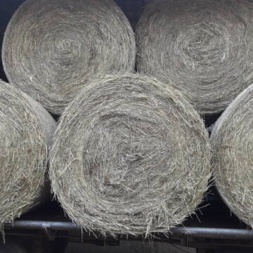
Rundballen Stroh
Elze-Esbeck
Hof Bartels
@Bartels
Stroh
Lieferant entlädt
Rundballen
Regenfrei
3 weitere...
B+

Luzerneheu 1.Schnitt
Teutschenthal
Nancy
@Haltergemeinschaft-TT
Heu
Empfänger lädt ab
Rundballen
Regenfrei
2 weitere...
B+


Futtermittel & Einstreu mit Lieferung!
Schwaara
MK-Agrarprodukte
@MK-Agrarprodukte
Heu
Empfänger lädt ab
Großballen
Regenfrei
2 weitere...
P+
Heu Rundballen zu verkaufen
Peine
Hof-Hoppenworth
@Hof-Hoppenworth
Heu
Empfänger lädt ab
Rundballen
Regenfrei
3 weitere...
B+
Leider kein Vorschaubild
Leider kein Vorschaubild
Bio-Heu Rundballen zu verkaufen
Biebertal
Lindenhoefe
@Lindenhoefe
Heu
Lieferant entlädt
Rundballen
Wird verladen
2 weitere...
B+

Futtersack HeuToy, Fressbremse in pink
Mechtersen
STALL-FREIde Marketing
@STALL-FREI-Marketing
Stundenlange Beschäftigung die
Koliken vorbeugt, geringe Staubinhalation mit
steuerbarer Futterentnahme
Leider kein Vorschaubild
Leider kein Vorschaubild
HD-Ballen Handballen Heu Heuballen Ernte 2024
Wolfsburg
Bendlin GbR
@Bendlin_GbR
Heu
Kleinballen/HD-Ballen
Regenfrei
Käufer lädt selbst
2 weitere...
B+
Leider kein Vorschaubild
Leider kein Vorschaubild
HD-Ballen Handballen Stroh Strohballen Ernte 2024
Wolfsburg
Bendlin GbR
@Bendlin_GbR
Stroh
Kleinballen/HD-Ballen
Regenfrei
Käufer lädt selbst
2 weitere...
B+
Deprecated: Creation of dynamic property Zend_View::$pageCount is deprecated in /var/www/stall-frei/htdocs/staging.stall-frei.de/library/vendor/shardj/zf1-future/library/Zend/View/Abstract.php on line 308
Deprecated: Creation of dynamic property Zend_View::$itemCountPerPage is deprecated in /var/www/stall-frei/htdocs/staging.stall-frei.de/library/vendor/shardj/zf1-future/library/Zend/View/Abstract.php on line 308
Deprecated: Creation of dynamic property Zend_View::$first is deprecated in /var/www/stall-frei/htdocs/staging.stall-frei.de/library/vendor/shardj/zf1-future/library/Zend/View/Abstract.php on line 308
Deprecated: Creation of dynamic property Zend_View::$current is deprecated in /var/www/stall-frei/htdocs/staging.stall-frei.de/library/vendor/shardj/zf1-future/library/Zend/View/Abstract.php on line 308
Deprecated: Creation of dynamic property Zend_View::$last is deprecated in /var/www/stall-frei/htdocs/staging.stall-frei.de/library/vendor/shardj/zf1-future/library/Zend/View/Abstract.php on line 308
Deprecated: Creation of dynamic property Zend_View::$next is deprecated in /var/www/stall-frei/htdocs/staging.stall-frei.de/library/vendor/shardj/zf1-future/library/Zend/View/Abstract.php on line 308
Deprecated: Creation of dynamic property Zend_View::$pagesInRange is deprecated in /var/www/stall-frei/htdocs/staging.stall-frei.de/library/vendor/shardj/zf1-future/library/Zend/View/Abstract.php on line 308
Deprecated: Creation of dynamic property Zend_View::$firstPageInRange is deprecated in /var/www/stall-frei/htdocs/staging.stall-frei.de/library/vendor/shardj/zf1-future/library/Zend/View/Abstract.php on line 308
Deprecated: Creation of dynamic property Zend_View::$lastPageInRange is deprecated in /var/www/stall-frei/htdocs/staging.stall-frei.de/library/vendor/shardj/zf1-future/library/Zend/View/Abstract.php on line 308
Deprecated: Creation of dynamic property Zend_View::$currentItemCount is deprecated in /var/www/stall-frei/htdocs/staging.stall-frei.de/library/vendor/shardj/zf1-future/library/Zend/View/Abstract.php on line 308
Deprecated: Creation of dynamic property Zend_View::$totalItemCount is deprecated in /var/www/stall-frei/htdocs/staging.stall-frei.de/library/vendor/shardj/zf1-future/library/Zend/View/Abstract.php on line 308
Deprecated: Creation of dynamic property Zend_View::$firstItemNumber is deprecated in /var/www/stall-frei/htdocs/staging.stall-frei.de/library/vendor/shardj/zf1-future/library/Zend/View/Abstract.php on line 308
Deprecated: Creation of dynamic property Zend_View::$lastItemNumber is deprecated in /var/www/stall-frei/htdocs/staging.stall-frei.de/library/vendor/shardj/zf1-future/library/Zend/View/Abstract.php on line 308
Deprecated: Creation of dynamic property Zend_View::$router is deprecated in /var/www/stall-frei/htdocs/staging.stall-frei.de/library/vendor/shardj/zf1-future/library/Zend/View/Abstract.php on line 308
Deprecated: Creation of dynamic property Zend_View::$urlParams is deprecated in /var/www/stall-frei/htdocs/staging.stall-frei.de/library/vendor/shardj/zf1-future/library/Zend/View/Abstract.php on line 308
Deprecated: Creation of dynamic property Zend_View::$showAds is deprecated in /var/www/stall-frei/htdocs/staging.stall-frei.de/library/vendor/shardj/zf1-future/library/Zend/View/Abstract.php on line 308
Deprecated: Creation of dynamic property Zend_View::$objectIds is deprecated in /var/www/stall-frei/htdocs/staging.stall-frei.de/library/vendor/shardj/zf1-future/library/Zend/View/Abstract.php on line 308
Deprecated: Creation of dynamic property Zend_View::$showNavbar is deprecated in /var/www/stall-frei/htdocs/staging.stall-frei.de/library/vendor/shardj/zf1-future/library/Zend/View/Abstract.php on line 308
Deprecated: Creation of dynamic property Zend_View::$showBreadcrumb is deprecated in /var/www/stall-frei/htdocs/staging.stall-frei.de/library/vendor/shardj/zf1-future/library/Zend/View/Abstract.php on line 308
Deprecated: Creation of dynamic property Zend_View::$showFooter is deprecated in /var/www/stall-frei/htdocs/staging.stall-frei.de/library/vendor/shardj/zf1-future/library/Zend/View/Abstract.php on line 308
Deprecated: Creation of dynamic property Zend_View::$showInternalAds is deprecated in /var/www/stall-frei/htdocs/staging.stall-frei.de/library/vendor/shardj/zf1-future/library/Zend/View/Abstract.php on line 308
Deprecated: Creation of dynamic property Zend_View::$blNoContent is deprecated in /var/www/stall-frei/htdocs/staging.stall-frei.de/library/vendor/shardj/zf1-future/library/Zend/View/Abstract.php on line 308
Deprecated: Creation of dynamic property Zend_View::$sMetaDesc is deprecated in /var/www/stall-frei/htdocs/staging.stall-frei.de/library/vendor/shardj/zf1-future/library/Zend/View/Abstract.php on line 308
Deprecated: Creation of dynamic property Zend_View::$useGmaps is deprecated in /var/www/stall-frei/htdocs/staging.stall-frei.de/library/vendor/shardj/zf1-future/library/Zend/View/Abstract.php on line 308
Deprecated: Creation of dynamic property Zend_View::$touches is deprecated in /var/www/stall-frei/htdocs/staging.stall-frei.de/library/vendor/shardj/zf1-future/library/Zend/View/Abstract.php on line 308
Deprecated: Creation of dynamic property Zend_View::$oProject is deprecated in /var/www/stall-frei/htdocs/staging.stall-frei.de/library/vendor/shardj/zf1-future/library/Zend/View/Abstract.php on line 308
Deprecated: Creation of dynamic property Zend_View::$pageHeadline is deprecated in /var/www/stall-frei/htdocs/staging.stall-frei.de/library/vendor/shardj/zf1-future/library/Zend/View/Abstract.php on line 308
Deprecated: Creation of dynamic property Zend_View::$disableLocationField is deprecated in /var/www/stall-frei/htdocs/staging.stall-frei.de/library/vendor/shardj/zf1-future/library/Zend/View/Abstract.php on line 308
Deprecated: Creation of dynamic property Zend_View::$isSearch is deprecated in /var/www/stall-frei/htdocs/staging.stall-frei.de/library/vendor/shardj/zf1-future/library/Zend/View/Abstract.php on line 308
Deprecated: Creation of dynamic property Zend_View::$pageTitle is deprecated in /var/www/stall-frei/htdocs/staging.stall-frei.de/library/vendor/shardj/zf1-future/library/Zend/View/Abstract.php on line 308
Deprecated: Creation of dynamic property Psf_Form_Element_Text::$class is deprecated in /var/www/stall-frei/htdocs/staging.stall-frei.de/library/vendor/shardj/zf1-future/library/Zend/Form/Element.php on line 874
Deprecated: Creation of dynamic property Psf_Form_Element_Text::$size is deprecated in /var/www/stall-frei/htdocs/staging.stall-frei.de/library/vendor/shardj/zf1-future/library/Zend/Form/Element.php on line 874
Deprecated: Creation of dynamic property Psf_Form_Element_Text::$placeholder is deprecated in /var/www/stall-frei/htdocs/staging.stall-frei.de/library/vendor/shardj/zf1-future/library/Zend/Form/Element.php on line 874
Deprecated: Creation of dynamic property Psf_Form_Element_Hidden::$class is deprecated in /var/www/stall-frei/htdocs/staging.stall-frei.de/library/vendor/shardj/zf1-future/library/Zend/Form/Element.php on line 874
Deprecated: Creation of dynamic property Psf_Form_Element_Hidden::$class is deprecated in /var/www/stall-frei/htdocs/staging.stall-frei.de/library/vendor/shardj/zf1-future/library/Zend/Form/Element.php on line 874
Deprecated: Creation of dynamic property Psf_Form_Element_Hidden::$class is deprecated in /var/www/stall-frei/htdocs/staging.stall-frei.de/library/vendor/shardj/zf1-future/library/Zend/Form/Element.php on line 874
Deprecated: Creation of dynamic property Psf_Form_Element_Hidden::$class is deprecated in /var/www/stall-frei/htdocs/staging.stall-frei.de/library/vendor/shardj/zf1-future/library/Zend/Form/Element.php on line 874
Deprecated: Creation of dynamic property Psf_Form_Element_Select::$class is deprecated in /var/www/stall-frei/htdocs/staging.stall-frei.de/library/vendor/shardj/zf1-future/library/Zend/Form/Element.php on line 874
Deprecated: Creation of dynamic property Psf_Form_Element_Select::$class is deprecated in /var/www/stall-frei/htdocs/staging.stall-frei.de/library/vendor/shardj/zf1-future/library/Zend/Form/Element.php on line 874
Deprecated: Creation of dynamic property Psf_Form_Element_Select::$class is deprecated in /var/www/stall-frei/htdocs/staging.stall-frei.de/library/vendor/shardj/zf1-future/library/Zend/Form/Element.php on line 874
Deprecated: Creation of dynamic property Psf_Form_Element_Select::$class is deprecated in /var/www/stall-frei/htdocs/staging.stall-frei.de/library/vendor/shardj/zf1-future/library/Zend/Form/Element.php on line 874
Deprecated: Creation of dynamic property Zend_View::$sort is deprecated in /var/www/stall-frei/htdocs/staging.stall-frei.de/library/vendor/shardj/zf1-future/library/Zend/View/Abstract.php on line 308
Deprecated: Creation of dynamic property Zend_View::$searchLocation is deprecated in /var/www/stall-frei/htdocs/staging.stall-frei.de/library/vendor/shardj/zf1-future/library/Zend/View/Abstract.php on line 308
Deprecated: Creation of dynamic property Zend_View::$locationHint is deprecated in /var/www/stall-frei/htdocs/staging.stall-frei.de/library/vendor/shardj/zf1-future/library/Zend/View/Abstract.php on line 308
Psf_GeoCoder_Abstract::getLocation: Katharinenberg Get Location CachedOrLive
Psf_GeoCoder_Abstract::getCachedOrLive: Katharinenberg
Psf_GeoCoder_OpenCageData::makeApiRequest: response:
Array
(
[documentation] => https://opencagedata.com/api
[licenses] => Array
(
[0] => Array
(
[name] => see attribution guide
[url] => https://opencagedata.com/credits
)
)
[results] => Array
(
[0] => Array
(
[bounds] => Array
(
[northeast] => Array
(
[lat] => 51.2013064
[lng] => 10.2811221
)
[southwest] => Array
(
[lat] => 51.1613064
[lng] => 10.2411221
)
)
[components] => Array
(
[ISO_3166-1_alpha-2] => DE
[ISO_3166-1_alpha-3] => DEU
[ISO_3166-2] => Array
(
[0] => DE-TH
)
[_category] => place
[_normalized_city] => Katharinenberg
[_type] => village
[continent] => Europe
[country] => Deutschland
[country_code] => de
[county] => Unstrut-Hainich-Kreis
[municipality] => Südeichsfeld
[political_union] => European Union
[postcode] => 99988
[state] => Thüringen
[state_code] => TH
[village] => Katharinenberg
)
[confidence] => 7
[formatted] => 99988 Katharinenberg, Deutschland
[geometry] => Array
(
[lat] => 51.1813064
[lng] => 10.2611221
)
)
[1] => Array
(
[bounds] => Array
(
[northeast] => Array
(
[lat] => 54.3121039
[lng] => 13.0882266
)
[southwest] => Array
(
[lat] => 54.3095365
[lng] => 13.0843467
)
)
[components] => Array
(
[ISO_3166-1_alpha-2] => DE
[ISO_3166-1_alpha-3] => DEU
[ISO_3166-2] => Array
(
[0] => DE-MV
)
[_category] => road
[_normalized_city] => Stralsund
[_type] => road
[continent] => Europe
[country] => Deutschland
[country_code] => de
[county] => Vorpommern-Rügen
[neighbourhood] => Altstadt
[political_union] => European Union
[postcode] => 18439
[road] => Katharinenberg
[road_type] => residential
[state] => Mecklenburg-Vorpommern
[state_code] => MV
[suburb] => Altstadt
[town] => Stralsund
)
[confidence] => 9
[formatted] => Katharinenberg, 18439 Stralsund, Deutschland
[geometry] => Array
(
[lat] => 54.3114457
[lng] => 13.0858583
)
)
[2] => Array
(
[bounds] => Array
(
[northeast] => Array
(
[lat] => 48.8107266
[lng] => 11.5455944
)
[southwest] => Array
(
[lat] => 48.7707266
[lng] => 11.5055944
)
)
[components] => Array
(
[ISO_3166-1_alpha-2] => DE
[ISO_3166-1_alpha-3] => DEU
[ISO_3166-2] => Array
(
[0] => DE-BY
)
[_category] => place
[_normalized_city] => Großmehring
[_type] => village
[city] => Großmehring
[continent] => Europe
[country] => Deutschland
[country_code] => de
[county] => Landkreis Eichstätt
[political_union] => European Union
[postcode] => 85098
[state] => Bayern
[state_code] => BY
[village] => Katharinenberg
)
[confidence] => 7
[formatted] => 85098 Katharinenberg, Deutschland
[geometry] => Array
(
[lat] => 48.7907266
[lng] => 11.5255944
)
)
[3] => Array
(
[bounds] => Array
(
[northeast] => Array
(
[lat] => 51.2161061
[lng] => 10.3056564
)
[southwest] => Array
(
[lat] => 51.1348483
[lng] => 10.2004423
)
)
[components] => Array
(
[ISO_3166-1_alpha-2] => DE
[ISO_3166-1_alpha-3] => DEU
[ISO_3166-2] => Array
(
[0] => DE-TH
)
[_category] => place
[_normalized_city] => Katharinenberg
[_type] => village
[continent] => Europe
[country] => Deutschland
[country_code] => de
[county] => Unstrut-Hainich-Kreis
[municipality] => Südeichsfeld
[political_union] => European Union
[state] => Thüringen
[state_code] => TH
[village] => Katharinenberg
)
[confidence] => 7
[formatted] => Katharinenberg, Thüringen, Deutschland
[geometry] => Array
(
[lat] => 51.175423
[lng] => 10.2655264
)
)
[4] => Array
(
[bounds] => Array
(
[northeast] => Array
(
[lat] => 52.538914
[lng] => 11.6187869
)
[southwest] => Array
(
[lat] => 52.538814
[lng] => 11.6186869
)
)
[components] => Array
(
[ISO_3166-1_alpha-2] => DE
[ISO_3166-1_alpha-3] => DEU
[ISO_3166-2] => Array
(
[0] => DE-ST
)
[_category] => natural/water
[_normalized_city] => Stendal
[_type] => peak
[continent] => Europe
[country] => Deutschland
[country_code] => de
[county] => Stendal
[peak] => Katharinenberg
[political_union] => European Union
[state] => Sachsen-Anhalt
[state_code] => ST
[town] => Stendal
)
[confidence] => 9
[formatted] => Katharinenberg, Stendal, Sachsen-Anhalt, Deutschland
[geometry] => Array
(
[lat] => 52.538864
[lng] => 11.6187369
)
)
[5] => Array
(
[bounds] => Array
(
[northeast] => Array
(
[lat] => 50.8326344
[lng] => 8.8063897
)
[southwest] => Array
(
[lat] => 50.8325344
[lng] => 8.8062897
)
)
[components] => Array
(
[ISO_3166-1_alpha-2] => DE
[ISO_3166-1_alpha-3] => DEU
[ISO_3166-2] => Array
(
[0] => DE-HE
)
[_category] => natural/water
[_normalized_city] => Marburg
[_type] => peak
[continent] => Europe
[country] => Deutschland
[country_code] => de
[county] => Landkreis Marburg-Biedenkopf
[peak] => Katharinenberg
[political_union] => European Union
[postcode] => 35091
[state] => Hessen
[state_code] => HE
[town] => Marburg
)
[confidence] => 9
[formatted] => Katharinenberg, 35091 Marburg, Deutschland
[geometry] => Array
(
[lat] => 50.8325844
[lng] => 8.8063397
)
)
[6] => Array
(
[bounds] => Array
(
[northeast] => Array
(
[lat] => 54.0729105
[lng] => 12.8229585
)
[southwest] => Array
(
[lat] => 54.0728105
[lng] => 12.8228585
)
)
[components] => Array
(
[ISO_3166-1_alpha-2] => DE
[ISO_3166-1_alpha-3] => DEU
[ISO_3166-2] => Array
(
[0] => DE-MV
)
[_category] => natural/water
[_normalized_city] => Tribsees
[_type] => peak
[continent] => Europe
[country] => Deutschland
[country_code] => de
[county] => Vorpommern-Rügen
[municipality] => Recknitz-Trebeltal
[peak] => Katharinenberg
[political_union] => European Union
[state] => Mecklenburg-Vorpommern
[state_code] => MV
[town] => Tribsees
)
[confidence] => 9
[formatted] => Katharinenberg, Tribsees, Mecklenburg-Vorpommern, Deutschland
[geometry] => Array
(
[lat] => 54.0728605
[lng] => 12.8229085
)
)
[7] => Array
(
[bounds] => Array
(
[northeast] => Array
(
[lat] => 48.3731971
[lng] => 10.8123618
)
[southwest] => Array
(
[lat] => 48.3730971
[lng] => 10.8122618
)
)
[components] => Array
(
[ISO_3166-1_alpha-2] => DE
[ISO_3166-1_alpha-3] => DEU
[ISO_3166-2] => Array
(
[0] => DE-BY
)
[_category] => natural/water
[_normalized_city] => Neusäß
[_type] => peak
[continent] => Europe
[country] => Deutschland
[country_code] => de
[county] => Landkreis Augsburg
[peak] => Katharinenberg
[political_union] => European Union
[postcode] => 86356
[state] => Bayern
[state_code] => BY
[town] => Neusäß
)
[confidence] => 9
[formatted] => Katharinenberg, 86356 Neusäß, Deutschland
[geometry] => Array
(
[lat] => 48.3731471
[lng] => 10.8123118
)
)
[8] => Array
(
[bounds] => Array
(
[northeast] => Array
(
[lat] => 48.1168842
[lng] => 7.6892057
)
[southwest] => Array
(
[lat] => 48.1167842
[lng] => 7.6891057
)
)
[components] => Array
(
[ISO_3166-1_alpha-2] => DE
[ISO_3166-1_alpha-3] => DEU
[ISO_3166-2] => Array
(
[0] => DE-BW
)
[_category] => natural/water
[_normalized_city] => Endingen am Kaiserstuhl
[_type] => peak
[continent] => Europe
[country] => Deutschland
[country_code] => de
[county] => Landkreis Emmendingen
[municipality] => GVV Nördlicher Kaiserstuhl
[peak] => Katharinenberg
[political_union] => European Union
[postcode] => 79346
[state] => Baden-Württemberg
[state_code] => BW
[town] => Endingen am Kaiserstuhl
)
[confidence] => 9
[formatted] => Katharinenberg, 79346 Endingen am Kaiserstuhl, Deutschland
[geometry] => Array
(
[lat] => 48.1168342
[lng] => 7.6891557
)
)
[9] => Array
(
[bounds] => Array
(
[northeast] => Array
(
[lat] => 54.0690184
[lng] => 13.7769351
)
[southwest] => Array
(
[lat] => 54.0689184
[lng] => 13.7768351
)
)
[components] => Array
(
[ISO_3166-1_alpha-2] => DE
[ISO_3166-1_alpha-3] => DEU
[ISO_3166-2] => Array
(
[0] => DE-MV
)
[_category] => natural/water
[_normalized_city] => Wolgast
[_type] => peak
[continent] => Europe
[country] => Deutschland
[country_code] => de
[county] => Vorpommern-Greifswald
[municipality] => Am Peenestrom
[peak] => Katharinenberg
[political_union] => European Union
[postcode] => 17438
[state] => Mecklenburg-Vorpommern
[state_code] => MV
[town] => Wolgast
)
[confidence] => 9
[formatted] => Katharinenberg, 17438 Wolgast, Deutschland
[geometry] => Array
(
[lat] => 54.0689684
[lng] => 13.7768851
)
)
)
[status] => Array
(
[code] => 200
[message] => OK
)
[stay_informed] => Array
(
[blog] => https://blog.opencagedata.com
[mastodon] => https://en.osm.town/@opencage
)
[thanks] => For using an OpenCage API
[timestamp] => Array
(
[created_http] => Mon, 09 Feb 2026 12:51:20 GMT
[created_unix] => 1770641480
)
[total_results] => 10
)
Psf_GeoCoder_Abstract::convertLocationResult
{"documentation":"https:\/\/opencagedata.com\/api","licenses":[{"name":"see attribution guide","url":"https:\/\/opencagedata.com\/credits"}],"results":[{"bounds":{"northeast":{"lat":51.2013064,"lng":10.2811221},"southwest":{"lat":51.1613064,"lng":10.2411221}},"components":{"ISO_3166-1_alpha-2":"DE","ISO_3166-1_alpha-3":"DEU","ISO_3166-2":["DE-TH"],"_category":"place","_normalized_city":"Katharinenberg","_type":"village","continent":"Europe","country":"Deutschland","country_code":"de","county":"Unstrut-Hainich-Kreis","municipality":"S\u00fcdeichsfeld","political_union":"European Union","postcode":"99988","state":"Th\u00fcringen","state_code":"TH","village":"Katharinenberg"},"confidence":7,"formatted":"99988 Katharinenberg, Deutschland","geometry":{"lat":51.1813064,"lng":10.2611221}},{"bounds":{"northeast":{"lat":54.3121039,"lng":13.0882266},"southwest":{"lat":54.3095365,"lng":13.0843467}},"components":{"ISO_3166-1_alpha-2":"DE","ISO_3166-1_alpha-3":"DEU","ISO_3166-2":["DE-MV"],"_category":"road","_normalized_city":"Stralsund","_type":"road","continent":"Europe","country":"Deutschland","country_code":"de","county":"Vorpommern-R\u00fcgen","neighbourhood":"Altstadt","political_union":"European Union","postcode":"18439","road":"Katharinenberg","road_type":"residential","state":"Mecklenburg-Vorpommern","state_code":"MV","suburb":"Altstadt","town":"Stralsund"},"confidence":9,"formatted":"Katharinenberg, 18439 Stralsund, Deutschland","geometry":{"lat":54.3114457,"lng":13.0858583}},{"bounds":{"northeast":{"lat":48.8107266,"lng":11.5455944},"southwest":{"lat":48.7707266,"lng":11.5055944}},"components":{"ISO_3166-1_alpha-2":"DE","ISO_3166-1_alpha-3":"DEU","ISO_3166-2":["DE-BY"],"_category":"place","_normalized_city":"Gro\u00dfmehring","_type":"village","city":"Gro\u00dfmehring","continent":"Europe","country":"Deutschland","country_code":"de","county":"Landkreis Eichst\u00e4tt","political_union":"European Union","postcode":"85098","state":"Bayern","state_code":"BY","village":"Katharinenberg"},"confidence":7,"formatted":"85098 Katharinenberg, Deutschland","geometry":{"lat":48.7907266,"lng":11.5255944}},{"bounds":{"northeast":{"lat":51.2161061,"lng":10.3056564},"southwest":{"lat":51.1348483,"lng":10.2004423}},"components":{"ISO_3166-1_alpha-2":"DE","ISO_3166-1_alpha-3":"DEU","ISO_3166-2":["DE-TH"],"_category":"place","_normalized_city":"Katharinenberg","_type":"village","continent":"Europe","country":"Deutschland","country_code":"de","county":"Unstrut-Hainich-Kreis","municipality":"S\u00fcdeichsfeld","political_union":"European Union","state":"Th\u00fcringen","state_code":"TH","village":"Katharinenberg"},"confidence":7,"formatted":"Katharinenberg, Th\u00fcringen, Deutschland","geometry":{"lat":51.175423,"lng":10.2655264}},{"bounds":{"northeast":{"lat":52.538914,"lng":11.6187869},"southwest":{"lat":52.538814,"lng":11.6186869}},"components":{"ISO_3166-1_alpha-2":"DE","ISO_3166-1_alpha-3":"DEU","ISO_3166-2":["DE-ST"],"_category":"natural\/water","_normalized_city":"Stendal","_type":"peak","continent":"Europe","country":"Deutschland","country_code":"de","county":"Stendal","peak":"Katharinenberg","political_union":"European Union","state":"Sachsen-Anhalt","state_code":"ST","town":"Stendal"},"confidence":9,"formatted":"Katharinenberg, Stendal, Sachsen-Anhalt, Deutschland","geometry":{"lat":52.538864,"lng":11.6187369}},{"bounds":{"northeast":{"lat":50.8326344,"lng":8.8063897},"southwest":{"lat":50.8325344,"lng":8.8062897}},"components":{"ISO_3166-1_alpha-2":"DE","ISO_3166-1_alpha-3":"DEU","ISO_3166-2":["DE-HE"],"_category":"natural\/water","_normalized_city":"Marburg","_type":"peak","continent":"Europe","country":"Deutschland","country_code":"de","county":"Landkreis Marburg-Biedenkopf","peak":"Katharinenberg","political_union":"European Union","postcode":"35091","state":"Hessen","state_code":"HE","town":"Marburg"},"confidence":9,"formatted":"Katharinenberg, 35091 Marburg, Deutschland","geometry":{"lat":50.8325844,"lng":8.8063397}},{"bounds":{"northeast":{"lat":54.0729105,"lng":12.8229585},"southwest":{"lat":54.0728105,"lng":12.8228585}},"components":{"ISO_3166-1_alpha-2":"DE","ISO_3166-1_alpha-3":"DEU","ISO_3166-2":["DE-MV"],"_category":"natural\/water","_normalized_city":"Tribsees","_type":"peak","continent":"Europe","country":"Deutschland","country_code":"de","county":"Vorpommern-R\u00fcgen","municipality":"Recknitz-Trebeltal","peak":"Katharinenberg","political_union":"European Union","state":"Mecklenburg-Vorpommern","state_code":"MV","town":"Tribsees"},"confidence":9,"formatted":"Katharinenberg, Tribsees, Mecklenburg-Vorpommern, Deutschland","geometry":{"lat":54.0728605,"lng":12.8229085}},{"bounds":{"northeast":{"lat":48.3731971,"lng":10.8123618},"southwest":{"lat":48.3730971,"lng":10.8122618}},"components":{"ISO_3166-1_alpha-2":"DE","ISO_3166-1_alpha-3":"DEU","ISO_3166-2":["DE-BY"],"_category":"natural\/water","_normalized_city":"Neus\u00e4\u00df","_type":"peak","continent":"Europe","country":"Deutschland","country_code":"de","county":"Landkreis Augsburg","peak":"Katharinenberg","political_union":"European Union","postcode":"86356","state":"Bayern","state_code":"BY","town":"Neus\u00e4\u00df"},"confidence":9,"formatted":"Katharinenberg, 86356 Neus\u00e4\u00df, Deutschland","geometry":{"lat":48.3731471,"lng":10.8123118}},{"bounds":{"northeast":{"lat":48.1168842,"lng":7.6892057},"southwest":{"lat":48.1167842,"lng":7.6891057}},"components":{"ISO_3166-1_alpha-2":"DE","ISO_3166-1_alpha-3":"DEU","ISO_3166-2":["DE-BW"],"_category":"natural\/water","_normalized_city":"Endingen am Kaiserstuhl","_type":"peak","continent":"Europe","country":"Deutschland","country_code":"de","county":"Landkreis Emmendingen","municipality":"GVV N\u00f6rdlicher Kaiserstuhl","peak":"Katharinenberg","political_union":"European Union","postcode":"79346","state":"Baden-W\u00fcrttemberg","state_code":"BW","town":"Endingen am Kaiserstuhl"},"confidence":9,"formatted":"Katharinenberg, 79346 Endingen am Kaiserstuhl, Deutschland","geometry":{"lat":48.1168342,"lng":7.6891557}},{"bounds":{"northeast":{"lat":54.0690184,"lng":13.7769351},"southwest":{"lat":54.0689184,"lng":13.7768351}},"components":{"ISO_3166-1_alpha-2":"DE","ISO_3166-1_alpha-3":"DEU","ISO_3166-2":["DE-MV"],"_category":"natural\/water","_normalized_city":"Wolgast","_type":"peak","continent":"Europe","country":"Deutschland","country_code":"de","county":"Vorpommern-Greifswald","municipality":"Am Peenestrom","peak":"Katharinenberg","political_union":"European Union","postcode":"17438","state":"Mecklenburg-Vorpommern","state_code":"MV","town":"Wolgast"},"confidence":9,"formatted":"Katharinenberg, 17438 Wolgast, Deutschland","geometry":{"lat":54.0689684,"lng":13.7768851}}],"status":{"code":200,"message":"OK"},"stay_informed":{"blog":"https:\/\/blog.opencagedata.com","mastodon":"https:\/\/en.osm.town\/@opencage"},"thanks":"For using an OpenCage API","timestamp":{"created_http":"Mon, 09 Feb 2026 12:51:20 GMT","created_unix":1770641480},"total_results":10}Array
(
[0] => stdClass Object
(
[bounds] => stdClass Object
(
[northeast] => stdClass Object
(
[lat] => 51.2013064
[lng] => 10.2811221
)
[southwest] => stdClass Object
(
[lat] => 51.1613064
[lng] => 10.2411221
)
)
[components] => stdClass Object
(
[ISO_3166-1_alpha-2] => DE
[ISO_3166-1_alpha-3] => DEU
[ISO_3166-2] => Array
(
[0] => DE-TH
)
[_category] => place
[_normalized_city] => Katharinenberg
[_type] => village
[continent] => Europe
[country] => Deutschland
[country_code] => de
[county] => Unstrut-Hainich-Kreis
[municipality] => Südeichsfeld
[political_union] => European Union
[postcode] => 99988
[state] => Thüringen
[state_code] => TH
[village] => Katharinenberg
)
[confidence] => 7
[formatted] => 99988 Katharinenberg, Deutschland
[geometry] => stdClass Object
(
[lat] => 51.1813064
[lng] => 10.2611221
)
)
[1] => stdClass Object
(
[bounds] => stdClass Object
(
[northeast] => stdClass Object
(
[lat] => 54.3121039
[lng] => 13.0882266
)
[southwest] => stdClass Object
(
[lat] => 54.3095365
[lng] => 13.0843467
)
)
[components] => stdClass Object
(
[ISO_3166-1_alpha-2] => DE
[ISO_3166-1_alpha-3] => DEU
[ISO_3166-2] => Array
(
[0] => DE-MV
)
[_category] => road
[_normalized_city] => Stralsund
[_type] => road
[continent] => Europe
[country] => Deutschland
[country_code] => de
[county] => Vorpommern-Rügen
[neighbourhood] => Altstadt
[political_union] => European Union
[postcode] => 18439
[road] => Katharinenberg
[road_type] => residential
[state] => Mecklenburg-Vorpommern
[state_code] => MV
[suburb] => Altstadt
[town] => Stralsund
)
[confidence] => 9
[formatted] => Katharinenberg, 18439 Stralsund, Deutschland
[geometry] => stdClass Object
(
[lat] => 54.3114457
[lng] => 13.0858583
)
)
[2] => stdClass Object
(
[bounds] => stdClass Object
(
[northeast] => stdClass Object
(
[lat] => 48.8107266
[lng] => 11.5455944
)
[southwest] => stdClass Object
(
[lat] => 48.7707266
[lng] => 11.5055944
)
)
[components] => stdClass Object
(
[ISO_3166-1_alpha-2] => DE
[ISO_3166-1_alpha-3] => DEU
[ISO_3166-2] => Array
(
[0] => DE-BY
)
[_category] => place
[_normalized_city] => Großmehring
[_type] => village
[city] => Großmehring
[continent] => Europe
[country] => Deutschland
[country_code] => de
[county] => Landkreis Eichstätt
[political_union] => European Union
[postcode] => 85098
[state] => Bayern
[state_code] => BY
[village] => Katharinenberg
)
[confidence] => 7
[formatted] => 85098 Katharinenberg, Deutschland
[geometry] => stdClass Object
(
[lat] => 48.7907266
[lng] => 11.5255944
)
)
[3] => stdClass Object
(
[bounds] => stdClass Object
(
[northeast] => stdClass Object
(
[lat] => 51.2161061
[lng] => 10.3056564
)
[southwest] => stdClass Object
(
[lat] => 51.1348483
[lng] => 10.2004423
)
)
[components] => stdClass Object
(
[ISO_3166-1_alpha-2] => DE
[ISO_3166-1_alpha-3] => DEU
[ISO_3166-2] => Array
(
[0] => DE-TH
)
[_category] => place
[_normalized_city] => Katharinenberg
[_type] => village
[continent] => Europe
[country] => Deutschland
[country_code] => de
[county] => Unstrut-Hainich-Kreis
[municipality] => Südeichsfeld
[political_union] => European Union
[state] => Thüringen
[state_code] => TH
[village] => Katharinenberg
)
[confidence] => 7
[formatted] => Katharinenberg, Thüringen, Deutschland
[geometry] => stdClass Object
(
[lat] => 51.175423
[lng] => 10.2655264
)
)
[4] => stdClass Object
(
[bounds] => stdClass Object
(
[northeast] => stdClass Object
(
[lat] => 52.538914
[lng] => 11.6187869
)
[southwest] => stdClass Object
(
[lat] => 52.538814
[lng] => 11.6186869
)
)
[components] => stdClass Object
(
[ISO_3166-1_alpha-2] => DE
[ISO_3166-1_alpha-3] => DEU
[ISO_3166-2] => Array
(
[0] => DE-ST
)
[_category] => natural/water
[_normalized_city] => Stendal
[_type] => peak
[continent] => Europe
[country] => Deutschland
[country_code] => de
[county] => Stendal
[peak] => Katharinenberg
[political_union] => European Union
[state] => Sachsen-Anhalt
[state_code] => ST
[town] => Stendal
)
[confidence] => 9
[formatted] => Katharinenberg, Stendal, Sachsen-Anhalt, Deutschland
[geometry] => stdClass Object
(
[lat] => 52.538864
[lng] => 11.6187369
)
)
[5] => stdClass Object
(
[bounds] => stdClass Object
(
[northeast] => stdClass Object
(
[lat] => 50.8326344
[lng] => 8.8063897
)
[southwest] => stdClass Object
(
[lat] => 50.8325344
[lng] => 8.8062897
)
)
[components] => stdClass Object
(
[ISO_3166-1_alpha-2] => DE
[ISO_3166-1_alpha-3] => DEU
[ISO_3166-2] => Array
(
[0] => DE-HE
)
[_category] => natural/water
[_normalized_city] => Marburg
[_type] => peak
[continent] => Europe
[country] => Deutschland
[country_code] => de
[county] => Landkreis Marburg-Biedenkopf
[peak] => Katharinenberg
[political_union] => European Union
[postcode] => 35091
[state] => Hessen
[state_code] => HE
[town] => Marburg
)
[confidence] => 9
[formatted] => Katharinenberg, 35091 Marburg, Deutschland
[geometry] => stdClass Object
(
[lat] => 50.8325844
[lng] => 8.8063397
)
)
[6] => stdClass Object
(
[bounds] => stdClass Object
(
[northeast] => stdClass Object
(
[lat] => 54.0729105
[lng] => 12.8229585
)
[southwest] => stdClass Object
(
[lat] => 54.0728105
[lng] => 12.8228585
)
)
[components] => stdClass Object
(
[ISO_3166-1_alpha-2] => DE
[ISO_3166-1_alpha-3] => DEU
[ISO_3166-2] => Array
(
[0] => DE-MV
)
[_category] => natural/water
[_normalized_city] => Tribsees
[_type] => peak
[continent] => Europe
[country] => Deutschland
[country_code] => de
[county] => Vorpommern-Rügen
[municipality] => Recknitz-Trebeltal
[peak] => Katharinenberg
[political_union] => European Union
[state] => Mecklenburg-Vorpommern
[state_code] => MV
[town] => Tribsees
)
[confidence] => 9
[formatted] => Katharinenberg, Tribsees, Mecklenburg-Vorpommern, Deutschland
[geometry] => stdClass Object
(
[lat] => 54.0728605
[lng] => 12.8229085
)
)
[7] => stdClass Object
(
[bounds] => stdClass Object
(
[northeast] => stdClass Object
(
[lat] => 48.3731971
[lng] => 10.8123618
)
[southwest] => stdClass Object
(
[lat] => 48.3730971
[lng] => 10.8122618
)
)
[components] => stdClass Object
(
[ISO_3166-1_alpha-2] => DE
[ISO_3166-1_alpha-3] => DEU
[ISO_3166-2] => Array
(
[0] => DE-BY
)
[_category] => natural/water
[_normalized_city] => Neusäß
[_type] => peak
[continent] => Europe
[country] => Deutschland
[country_code] => de
[county] => Landkreis Augsburg
[peak] => Katharinenberg
[political_union] => European Union
[postcode] => 86356
[state] => Bayern
[state_code] => BY
[town] => Neusäß
)
[confidence] => 9
[formatted] => Katharinenberg, 86356 Neusäß, Deutschland
[geometry] => stdClass Object
(
[lat] => 48.3731471
[lng] => 10.8123118
)
)
[8] => stdClass Object
(
[bounds] => stdClass Object
(
[northeast] => stdClass Object
(
[lat] => 48.1168842
[lng] => 7.6892057
)
[southwest] => stdClass Object
(
[lat] => 48.1167842
[lng] => 7.6891057
)
)
[components] => stdClass Object
(
[ISO_3166-1_alpha-2] => DE
[ISO_3166-1_alpha-3] => DEU
[ISO_3166-2] => Array
(
[0] => DE-BW
)
[_category] => natural/water
[_normalized_city] => Endingen am Kaiserstuhl
[_type] => peak
[continent] => Europe
[country] => Deutschland
[country_code] => de
[county] => Landkreis Emmendingen
[municipality] => GVV Nördlicher Kaiserstuhl
[peak] => Katharinenberg
[political_union] => European Union
[postcode] => 79346
[state] => Baden-Württemberg
[state_code] => BW
[town] => Endingen am Kaiserstuhl
)
[confidence] => 9
[formatted] => Katharinenberg, 79346 Endingen am Kaiserstuhl, Deutschland
[geometry] => stdClass Object
(
[lat] => 48.1168342
[lng] => 7.6891557
)
)
[9] => stdClass Object
(
[bounds] => stdClass Object
(
[northeast] => stdClass Object
(
[lat] => 54.0690184
[lng] => 13.7769351
)
[southwest] => stdClass Object
(
[lat] => 54.0689184
[lng] => 13.7768351
)
)
[components] => stdClass Object
(
[ISO_3166-1_alpha-2] => DE
[ISO_3166-1_alpha-3] => DEU
[ISO_3166-2] => Array
(
[0] => DE-MV
)
[_category] => natural/water
[_normalized_city] => Wolgast
[_type] => peak
[continent] => Europe
[country] => Deutschland
[country_code] => de
[county] => Vorpommern-Greifswald
[municipality] => Am Peenestrom
[peak] => Katharinenberg
[political_union] => European Union
[postcode] => 17438
[state] => Mecklenburg-Vorpommern
[state_code] => MV
[town] => Wolgast
)
[confidence] => 9
[formatted] => Katharinenberg, 17438 Wolgast, Deutschland
[geometry] => stdClass Object
(
[lat] => 54.0689684
[lng] => 13.7768851
)
)
)
Psf_GeoCoder_OpenCageData::getKeyMap: 0
stdClass Object
(
    [bounds] => stdClass Object
        (
            [northeast] => stdClass Object
                (
                    [lat] => 51.2013064
                    [lng] => 10.2811221
                )

            [southwest] => stdClass Object
                (
                    [lat] => 51.1613064
                    [lng] => 10.2411221
                )

        )

    [components] => stdClass Object
        (
            [ISO_3166-1_alpha-2] => DE
            [ISO_3166-1_alpha-3] => DEU
            [ISO_3166-2] => Array
                (
                    [0] => DE-TH
                )

            [_category] => place
            [_normalized_city] => Katharinenberg
            [_type] => village
            [continent] => Europe
            [country] => Deutschland
            [country_code] => de
            [county] => Unstrut-Hainich-Kreis
            [municipality] => Südeichsfeld
            [political_union] => European Union
            [postcode] => 99988
            [state] => Thüringen
            [state_code] => TH
            [village] => Katharinenberg
        )

    [confidence] => 7
    [formatted] => 99988 Katharinenberg, Deutschland
    [geometry] => stdClass Object
        (
            [lat] => 51.1813064
            [lng] => 10.2611221
        )

)
Psf_GeoCoder_OpenCageData::getCounty: Unstrut-Hainich-Kreis
Psf_GeoCoder_OpenCageData::addMissingData REFETCH!
Array
(
    [address] => 99988 Katharinenberg, Deutschland
    [type] => village
    [street] =>
    [city] => Katharinenberg
    [county] => Unstrut-Hainich-Kreis
    [state] => Thüringen
    [zip] => 99988
    [country] => Deutschland
    [suburb] =>
    [countrycode] => de
    [latitude] => 51.1813064
    [longitude] => 10.2611221
    [accuracy] => 1
    [confidence] => 7
    [bounds] => stdClass Object
        (
            [northeast] => stdClass Object
                (
                    [lat] => 51.2013064
                    [lng] => 10.2811221
                )

            [southwest] => stdClass Object
                (
                    [lat] => 51.1613064
                    [lng] => 10.2411221
                )

        )

)
reformat!
Array
(
    [address] => 99988 Katharinenberg, Deutschland
    [type] => village
    [street] =>
    [city] => Katharinenberg
    [county] => Unstrut-Hainich-Kreis
    [state] => Thüringen
    [zip] => 99988
    [country] => Deutschland
    [suburb] =>
    [countrycode] => de
    [latitude] => 51.1813064
    [longitude] => 10.2611221
    [accuracy] => 1
    [confidence] => 7
    [bounds] => stdClass Object
        (
            [northeast] => stdClass Object
                (
                    [lat] => 51.2013064
                    [lng] => 10.2811221
                )

            [southwest] => stdClass Object
                (
                    [lat] => 51.1613064
                    [lng] => 10.2411221
                )

        )

    [place] => 99988 Katharinenberg, Thüringen
    [hash] => 0d359f3a3b171a097773bc92900c5c7f
)
Psf_GeoCoder_OpenCageData::getKeyMap: 1
stdClass Object
(
    [bounds] => stdClass Object
        (
            [northeast] => stdClass Object
                (
                    [lat] => 54.3121039
                    [lng] => 13.0882266
                )

            [southwest] => stdClass Object
                (
                    [lat] => 54.3095365
                    [lng] => 13.0843467
                )

        )

    [components] => stdClass Object
        (
            [ISO_3166-1_alpha-2] => DE
            [ISO_3166-1_alpha-3] => DEU
            [ISO_3166-2] => Array
                (
                    [0] => DE-MV
                )

            [_category] => road
            [_normalized_city] => Stralsund
            [_type] => road
            [continent] => Europe
            [country] => Deutschland
            [country_code] => de
            [county] => Vorpommern-Rügen
            [neighbourhood] => Altstadt
            [political_union] => European Union
            [postcode] => 18439
            [road] => Katharinenberg
            [road_type] => residential
            [state] => Mecklenburg-Vorpommern
            [state_code] => MV
            [suburb] => Altstadt
            [town] => Stralsund
        )

    [confidence] => 9
    [formatted] => Katharinenberg, 18439 Stralsund, Deutschland
    [geometry] => stdClass Object
        (
            [lat] => 54.3114457
            [lng] => 13.0858583
        )

)
Psf_GeoCoder_OpenCageData::getCounty: Vorpommern-Rügen
Psf_GeoCoder_OpenCageData::addMissingData REFETCH!
Array
(
    [address] => Katharinenberg, 18439 Stralsund, Deutschland
    [type] => road
    [street] => Katharinenberg
    [city] => Stralsund
    [county] => Vorpommern-Rügen
    [state] => Mecklenburg-Vorpommern
    [zip] => 18439
    [country] => Deutschland
    [suburb] => Altstadt
    [countrycode] => de
    [latitude] => 54.3114457
    [longitude] => 13.0858583
    [accuracy] => 1
    [confidence] => 9
    [bounds] => stdClass Object
        (
            [northeast] => stdClass Object
                (
                    [lat] => 54.3121039
                    [lng] => 13.0882266
                )

            [southwest] => stdClass Object
                (
                    [lat] => 54.3095365
                    [lng] => 13.0843467
                )

        )

)
reformat!
Array
(
    [address] => Katharinenberg, 18439 Stralsund, Deutschland
    [type] => road
    [street] => Katharinenberg
    [city] => Stralsund
    [county] => Vorpommern-Rügen
    [state] => Mecklenburg-Vorpommern
    [zip] => 18439
    [country] => Deutschland
    [suburb] => Altstadt
    [countrycode] => de
    [latitude] => 54.3114457
    [longitude] => 13.0858583
    [accuracy] => 1
    [confidence] => 9
    [bounds] => stdClass Object
        (
            [northeast] => stdClass Object
                (
                    [lat] => 54.3121039
                    [lng] => 13.0882266
                )

            [southwest] => stdClass Object
                (
                    [lat] => 54.3095365
                    [lng] => 13.0843467
                )

        )

    [place] => Katharinenberg, 18439 Stralsund, Mecklenburg-Vorpommern
    [hash] => ccbe935278cb3d9c4e2db299d664c6c9
)
Psf_GeoCoder_OpenCageData::getKeyMap: 2
stdClass Object
(
    [bounds] => stdClass Object
        (
            [northeast] => stdClass Object
                (
                    [lat] => 48.8107266
                    [lng] => 11.5455944
                )

            [southwest] => stdClass Object
                (
                    [lat] => 48.7707266
                    [lng] => 11.5055944
                )

        )

    [components] => stdClass Object
        (
            [ISO_3166-1_alpha-2] => DE
            [ISO_3166-1_alpha-3] => DEU
            [ISO_3166-2] => Array
                (
                    [0] => DE-BY
                )

            [_category] => place
            [_normalized_city] => Großmehring
            [_type] => village
            [city] => Großmehring
            [continent] => Europe
            [country] => Deutschland
            [country_code] => de
            [county] => Landkreis Eichstätt
            [political_union] => European Union
            [postcode] => 85098
            [state] => Bayern
            [state_code] => BY
            [village] => Katharinenberg
        )

    [confidence] => 7
    [formatted] => 85098 Katharinenberg, Deutschland
    [geometry] => stdClass Object
        (
            [lat] => 48.7907266
            [lng] => 11.5255944
        )

)
Psf_GeoCoder_OpenCageData::getCounty: Eichstätt
Psf_GeoCoder_OpenCageData::addMissingData REFETCH!
Array
(
    [address] => 85098 Katharinenberg, Deutschland
    [type] => village
    [street] =>
    [city] => Katharinenberg
    [county] => Eichstätt
    [state] => Bayern
    [zip] => 85098
    [country] => Deutschland
    [suburb] =>
    [countrycode] => de
    [latitude] => 48.7907266
    [longitude] => 11.5255944
    [accuracy] => 1
    [confidence] => 7
    [bounds] => stdClass Object
        (
            [northeast] => stdClass Object
                (
                    [lat] => 48.8107266
                    [lng] => 11.5455944
                )

            [southwest] => stdClass Object
                (
                    [lat] => 48.7707266
                    [lng] => 11.5055944
                )

        )

)
reformat!
Array
(
    [address] => 85098 Katharinenberg, Deutschland
    [type] => village
    [street] =>
    [city] => Katharinenberg
    [county] => Eichstätt
    [state] => Bayern
    [zip] => 85098
    [country] => Deutschland
    [suburb] =>
    [countrycode] => de
    [latitude] => 48.7907266
    [longitude] => 11.5255944
    [accuracy] => 1
    [confidence] => 7
    [bounds] => stdClass Object
        (
            [northeast] => stdClass Object
                (
                    [lat] => 48.8107266
                    [lng] => 11.5455944
                )

            [southwest] => stdClass Object
                (
                    [lat] => 48.7707266
                    [lng] => 11.5055944
                )

        )

    [place] => 85098 Katharinenberg, Bayern
    [hash] => d38cd2949f9a2f49159279ec6a3dfbb3
)
Psf_GeoCoder_OpenCageData::getKeyMap: 3
stdClass Object
(
    [bounds] => stdClass Object
        (
            [northeast] => stdClass Object
                (
                    [lat] => 51.2161061
                    [lng] => 10.3056564
                )

            [southwest] => stdClass Object
                (
                    [lat] => 51.1348483
                    [lng] => 10.2004423
                )

        )

    [components] => stdClass Object
        (
            [ISO_3166-1_alpha-2] => DE
            [ISO_3166-1_alpha-3] => DEU
            [ISO_3166-2] => Array
                (
                    [0] => DE-TH
                )

            [_category] => place
            [_normalized_city] => Katharinenberg
            [_type] => village
            [continent] => Europe
            [country] => Deutschland
            [country_code] => de
            [county] => Unstrut-Hainich-Kreis
            [municipality] => Südeichsfeld
            [political_union] => European Union
            [state] => Thüringen
            [state_code] => TH
            [village] => Katharinenberg
        )

    [confidence] => 7
    [formatted] => Katharinenberg, Thüringen, Deutschland
    [geometry] => stdClass Object
        (
            [lat] => 51.175423
            [lng] => 10.2655264
        )

)
Psf_GeoCoder_OpenCageData::getCounty: Unstrut-Hainich-Kreis
Psf_GeoCoder_OpenCageData::addMissingData REFETCH!
Array
(
    [address] => Katharinenberg, Thüringen, Deutschland
    [type] => village
    [street] =>
    [city] => Katharinenberg
    [county] => Unstrut-Hainich-Kreis
    [state] => Thüringen
    [zip] =>
    [country] => Deutschland
    [suburb] =>
    [countrycode] => de
    [latitude] => 51.175423
    [longitude] => 10.2655264
    [accuracy] => 1
    [confidence] => 7
    [bounds] => stdClass Object
        (
            [northeast] => stdClass Object
                (
                    [lat] => 51.2161061
                    [lng] => 10.3056564
                )

            [southwest] => stdClass Object
                (
                    [lat] => 51.1348483
                    [lng] => 10.2004423
                )

        )

)
reformat!
Array
(
    [address] => Katharinenberg, Thüringen, Deutschland
    [type] => village
    [street] =>
    [city] => Katharinenberg
    [county] => Unstrut-Hainich-Kreis
    [state] => Thüringen
    [zip] =>
    [country] => Deutschland
    [suburb] =>
    [countrycode] => de
    [latitude] => 51.175423
    [longitude] => 10.2655264
    [accuracy] => 1
    [confidence] => 7
    [bounds] => stdClass Object
        (
            [northeast] => stdClass Object
                (
                    [lat] => 51.2161061
                    [lng] => 10.3056564
                )

            [southwest] => stdClass Object
                (
                    [lat] => 51.1348483
                    [lng] => 10.2004423
                )

        )

    [place] => Katharinenberg, Thüringen
    [hash] => 18f004dc339ff1194291647b71600a46
)
Psf_GeoCoder_OpenCageData::getKeyMap: 4
stdClass Object
(
    [bounds] => stdClass Object
        (
            [northeast] => stdClass Object
                (
                    [lat] => 52.538914
                    [lng] => 11.6187869
                )

            [southwest] => stdClass Object
                (
                    [lat] => 52.538814
                    [lng] => 11.6186869
                )

        )

    [components] => stdClass Object
        (
            [ISO_3166-1_alpha-2] => DE
            [ISO_3166-1_alpha-3] => DEU
            [ISO_3166-2] => Array
                (
                    [0] => DE-ST
                )

            [_category] => natural/water
            [_normalized_city] => Stendal
            [_type] => peak
            [continent] => Europe
            [country] => Deutschland
            [country_code] => de
            [county] => Stendal
            [peak] => Katharinenberg
            [political_union] => European Union
            [state] => Sachsen-Anhalt
            [state_code] => ST
            [town] => Stendal
        )

    [confidence] => 9
    [formatted] => Katharinenberg, Stendal, Sachsen-Anhalt, Deutschland
    [geometry] => stdClass Object
        (
            [lat] => 52.538864
            [lng] => 11.6187369
        )

)
Psf_GeoCoder_OpenCageData::getCounty: Stendal
Psf_GeoCoder_OpenCageData::addMissingData REFETCH!
Array
(
    [address] => Katharinenberg, Stendal, Sachsen-Anhalt, Deutschland
    [type] => peak
    [street] =>
    [city] => Stendal
    [county] => Stendal
    [state] => Sachsen-Anhalt
    [zip] =>
    [country] => Deutschland
    [suburb] =>
    [countrycode] => de
    [latitude] => 52.538864
    [longitude] => 11.6187369
    [accuracy] => 1
    [confidence] => 9
    [bounds] => stdClass Object
        (
            [northeast] => stdClass Object
                (
                    [lat] => 52.538914
                    [lng] => 11.6187869
                )

            [southwest] => stdClass Object
                (
                    [lat] => 52.538814
                    [lng] => 11.6186869
                )

        )

)
reformat!
Array
(
    [address] => Katharinenberg, Stendal, Sachsen-Anhalt, Deutschland
    [type] => peak
    [street] =>
    [city] => Stendal
    [county] => Stendal
    [state] => Sachsen-Anhalt
    [zip] =>
    [country] => Deutschland
    [suburb] =>
    [countrycode] => de
    [latitude] => 52.538864
    [longitude] => 11.6187369
    [accuracy] => 1
    [confidence] => 9
    [bounds] => stdClass Object
        (
            [northeast] => stdClass Object
                (
                    [lat] => 52.538914
                    [lng] => 11.6187869
                )

            [southwest] => stdClass Object
                (
                    [lat] => 52.538814
                    [lng] => 11.6186869
                )

        )

    [place] => Stendal, Sachsen-Anhalt
    [hash] => 8303ec602e62b5384b248ce64006070b
)
Psf_GeoCoder_OpenCageData::getKeyMap: 5
stdClass Object
(
    [bounds] => stdClass Object
        (
            [northeast] => stdClass Object
                (
                    [lat] => 50.8326344
                    [lng] => 8.8063897
                )

            [southwest] => stdClass Object
                (
                    [lat] => 50.8325344
                    [lng] => 8.8062897
                )

        )

    [components] => stdClass Object
        (
            [ISO_3166-1_alpha-2] => DE
            [ISO_3166-1_alpha-3] => DEU
            [ISO_3166-2] => Array
                (
                    [0] => DE-HE
                )

            [_category] => natural/water
            [_normalized_city] => Marburg
            [_type] => peak
            [continent] => Europe
            [country] => Deutschland
            [country_code] => de
            [county] => Landkreis Marburg-Biedenkopf
            [peak] => Katharinenberg
            [political_union] => European Union
            [postcode] => 35091
            [state] => Hessen
            [state_code] => HE
            [town] => Marburg
        )

    [confidence] => 9
    [formatted] => Katharinenberg, 35091 Marburg, Deutschland
    [geometry] => stdClass Object
        (
            [lat] => 50.8325844
            [lng] => 8.8063397
        )

)
Psf_GeoCoder_OpenCageData::getCounty: Marburg-Biedenkopf
Psf_GeoCoder_OpenCageData::addMissingData REFETCH!
Array
(
    [address] => Katharinenberg, 35091 Marburg, Deutschland
    [type] => peak
    [street] =>
    [city] => Marburg
    [county] => Marburg-Biedenkopf
    [state] => Hessen
    [zip] => 35091
    [country] => Deutschland
    [suburb] =>
    [countrycode] => de
    [latitude] => 50.8325844
    [longitude] => 8.8063397
    [accuracy] => 1
    [confidence] => 9
    [bounds] => stdClass Object
        (
            [northeast] => stdClass Object
                (
                    [lat] => 50.8326344
                    [lng] => 8.8063897
                )

            [southwest] => stdClass Object
                (
                    [lat] => 50.8325344
                    [lng] => 8.8062897
                )

        )

)
reformat!
Array
(
    [address] => Katharinenberg, 35091 Marburg, Deutschland
    [type] => peak
    [street] =>
    [city] => Marburg
    [county] => Marburg-Biedenkopf
    [state] => Hessen
    [zip] => 35091
    [country] => Deutschland
    [suburb] =>
    [countrycode] => de
    [latitude] => 50.8325844
    [longitude] => 8.8063397
    [accuracy] => 1
    [confidence] => 9
    [bounds] => stdClass Object
        (
            [northeast] => stdClass Object
                (
                    [lat] => 50.8326344
                    [lng] => 8.8063897
                )

            [southwest] => stdClass Object
                (
                    [lat] => 50.8325344
                    [lng] => 8.8062897
                )

        )

    [place] => 35091 Marburg, Hessen
    [hash] => f93c679dc00e6f57283ac75c460c48b7
)
Psf_GeoCoder_OpenCageData::getKeyMap: 6
stdClass Object
(
    [bounds] => stdClass Object
        (
            [northeast] => stdClass Object
                (
                    [lat] => 54.0729105
                    [lng] => 12.8229585
                )

            [southwest] => stdClass Object
                (
                    [lat] => 54.0728105
                    [lng] => 12.8228585
                )

        )

    [components] => stdClass Object
        (
            [ISO_3166-1_alpha-2] => DE
            [ISO_3166-1_alpha-3] => DEU
            [ISO_3166-2] => Array
                (
                    [0] => DE-MV
                )

            [_category] => natural/water
            [_normalized_city] => Tribsees
            [_type] => peak
            [continent] => Europe
            [country] => Deutschland
            [country_code] => de
            [county] => Vorpommern-Rügen
            [municipality] => Recknitz-Trebeltal
            [peak] => Katharinenberg
            [political_union] => European Union
            [state] => Mecklenburg-Vorpommern
            [state_code] => MV
            [town] => Tribsees
        )

    [confidence] => 9
    [formatted] => Katharinenberg, Tribsees, Mecklenburg-Vorpommern, Deutschland
    [geometry] => stdClass Object
        (
            [lat] => 54.0728605
            [lng] => 12.8229085
        )

)
Psf_GeoCoder_OpenCageData::getCounty: Vorpommern-Rügen
Psf_GeoCoder_OpenCageData::addMissingData REFETCH!
Array
(
    [address] => Katharinenberg, Tribsees, Mecklenburg-Vorpommern, Deutschland
    [type] => peak
    [street] =>
    [city] => Tribsees
    [county] => Vorpommern-Rügen
    [state] => Mecklenburg-Vorpommern
    [zip] =>
    [country] => Deutschland
    [suburb] =>
    [countrycode] => de
    [latitude] => 54.0728605
    [longitude] => 12.8229085
    [accuracy] => 1
    [confidence] => 9
    [bounds] => stdClass Object
        (
            [northeast] => stdClass Object
                (
                    [lat] => 54.0729105
                    [lng] => 12.8229585
                )

            [southwest] => stdClass Object
                (
                    [lat] => 54.0728105
                    [lng] => 12.8228585
                )

        )

)
reformat!
Array
(
    [address] => Katharinenberg, Tribsees, Mecklenburg-Vorpommern, Deutschland
    [type] => peak
    [street] =>
    [city] => Tribsees
    [county] => Vorpommern-Rügen
    [state] => Mecklenburg-Vorpommern
    [zip] =>
    [country] => Deutschland
    [suburb] =>
    [countrycode] => de
    [latitude] => 54.0728605
    [longitude] => 12.8229085
    [accuracy] => 1
    [confidence] => 9
    [bounds] => stdClass Object
        (
            [northeast] => stdClass Object
                (
                    [lat] => 54.0729105
                    [lng] => 12.8229585
                )

            [southwest] => stdClass Object
                (
                    [lat] => 54.0728105
                    [lng] => 12.8228585
                )

        )

    [place] => Tribsees, Mecklenburg-Vorpommern
    [hash] => 1ba3cfd2a74f7bc1c78c49b40ff64f45
)
Psf_GeoCoder_OpenCageData::getKeyMap: 7
stdClass Object
(
    [bounds] => stdClass Object
        (
            [northeast] => stdClass Object
                (
                    [lat] => 48.3731971
                    [lng] => 10.8123618
                )

            [southwest] => stdClass Object
                (
                    [lat] => 48.3730971
                    [lng] => 10.8122618
                )

        )

    [components] => stdClass Object
        (
            [ISO_3166-1_alpha-2] => DE
            [ISO_3166-1_alpha-3] => DEU
            [ISO_3166-2] => Array
                (
                    [0] => DE-BY
                )

            [_category] => natural/water
            [_normalized_city] => Neusäß
            [_type] => peak
            [continent] => Europe
            [country] => Deutschland
            [country_code] => de
            [county] => Landkreis Augsburg
            [peak] => Katharinenberg
            [political_union] => European Union
            [postcode] => 86356
            [state] => Bayern
            [state_code] => BY
            [town] => Neusäß
        )

    [confidence] => 9
    [formatted] => Katharinenberg, 86356 Neusäß, Deutschland
    [geometry] => stdClass Object
        (
            [lat] => 48.3731471
            [lng] => 10.8123118
        )

)
Psf_GeoCoder_OpenCageData::getCounty: Augsburg
Psf_GeoCoder_OpenCageData::addMissingData REFETCH!
Array
(
    [address] => Katharinenberg, 86356 Neusäß, Deutschland
    [type] => peak
    [street] =>
    [city] => Neusäß
    [county] => Augsburg
    [state] => Bayern
    [zip] => 86356
    [country] => Deutschland
    [suburb] =>
    [countrycode] => de
    [latitude] => 48.3731471
    [longitude] => 10.8123118
    [accuracy] => 1
    [confidence] => 9
    [bounds] => stdClass Object
        (
            [northeast] => stdClass Object
                (
                    [lat] => 48.3731971
                    [lng] => 10.8123618
                )

            [southwest] => stdClass Object
                (
                    [lat] => 48.3730971
                    [lng] => 10.8122618
                )

        )

)
reformat!
Array
(
    [address] => Katharinenberg, 86356 Neusäß, Deutschland
    [type] => peak
    [street] =>
    [city] => Neusäß
    [county] => Augsburg
    [state] => Bayern
    [zip] => 86356
    [country] => Deutschland
    [suburb] =>
    [countrycode] => de
    [latitude] => 48.3731471
    [longitude] => 10.8123118
    [accuracy] => 1
    [confidence] => 9
    [bounds] => stdClass Object
        (
            [northeast] => stdClass Object
                (
                    [lat] => 48.3731971
                    [lng] => 10.8123618
                )

            [southwest] => stdClass Object
                (
                    [lat] => 48.3730971
                    [lng] => 10.8122618
                )

        )

    [place] => 86356 Neusäß, Bayern
    [hash] => 2752849e1db53b4ef0fb7fe427abdb9d
)
Psf_GeoCoder_OpenCageData::getKeyMap: 8
stdClass Object
(
    [bounds] => stdClass Object
        (
            [northeast] => stdClass Object
                (
                    [lat] => 48.1168842
                    [lng] => 7.6892057
                )

            [southwest] => stdClass Object
                (
                    [lat] => 48.1167842
                    [lng] => 7.6891057
                )

        )

    [components] => stdClass Object
        (
            [ISO_3166-1_alpha-2] => DE
            [ISO_3166-1_alpha-3] => DEU
            [ISO_3166-2] => Array
                (
                    [0] => DE-BW
                )

            [_category] => natural/water
            [_normalized_city] => Endingen am Kaiserstuhl
            [_type] => peak
            [continent] => Europe
            [country] => Deutschland
            [country_code] => de
            [county] => Landkreis Emmendingen
            [municipality] => GVV Nördlicher Kaiserstuhl
            [peak] => Katharinenberg
            [political_union] => European Union
            [postcode] => 79346
            [state] => Baden-Württemberg
            [state_code] => BW
            [town] => Endingen am Kaiserstuhl
        )

    [confidence] => 9
    [formatted] => Katharinenberg, 79346 Endingen am Kaiserstuhl, Deutschland
    [geometry] => stdClass Object
        (
            [lat] => 48.1168342
            [lng] => 7.6891557
        )

)
Psf_GeoCoder_OpenCageData::getCounty: Emmendingen
Psf_GeoCoder_OpenCageData::addMissingData REFETCH!
Array
(
    [address] => Katharinenberg, 79346 Endingen am Kaiserstuhl, Deutschland
    [type] => peak
    [street] =>
    [city] => Endingen am Kaiserstuhl
    [county] => Emmendingen
    [state] => Baden-Württemberg
    [zip] => 79346
    [country] => Deutschland
    [suburb] =>
    [countrycode] => de
    [latitude] => 48.1168342
    [longitude] => 7.6891557
    [accuracy] => 1
    [confidence] => 9
    [bounds] => stdClass Object
        (
            [northeast] => stdClass Object
                (
                    [lat] => 48.1168842
                    [lng] => 7.6892057
                )

            [southwest] => stdClass Object
                (
                    [lat] => 48.1167842
                    [lng] => 7.6891057
                )

        )

)
reformat!
Array
(
    [address] => Katharinenberg, 79346 Endingen am Kaiserstuhl, Deutschland
    [type] => peak
    [street] =>
    [city] => Endingen am Kaiserstuhl
    [county] => Emmendingen
    [state] => Baden-Württemberg
    [zip] => 79346
    [country] => Deutschland
    [suburb] =>
    [countrycode] => de
    [latitude] => 48.1168342
    [longitude] => 7.6891557
    [accuracy] => 1
    [confidence] => 9
    [bounds] => stdClass Object
        (
            [northeast] => stdClass Object
                (
                    [lat] => 48.1168842
                    [lng] => 7.6892057
                )

            [southwest] => stdClass Object
                (
                    [lat] => 48.1167842
                    [lng] => 7.6891057
                )

        )

    [place] => 79346 Endingen am Kaiserstuhl, Baden-Württemberg
    [hash] => fd6cf2626dfd7319c1b8f7c93e166255
)
Psf_GeoCoder_OpenCageData::getKeyMap: 9
stdClass Object
(
    [bounds] => stdClass Object
        (
            [northeast] => stdClass Object
                (
                    [lat] => 54.0690184
                    [lng] => 13.7769351
                )

            [southwest] => stdClass Object
                (
                    [lat] => 54.0689184
                    [lng] => 13.7768351
                )

        )

    [components] => stdClass Object
        (
            [ISO_3166-1_alpha-2] => DE
            [ISO_3166-1_alpha-3] => DEU
            [ISO_3166-2] => Array
                (
                    [0] => DE-MV
                )

            [_category] => natural/water
            [_normalized_city] => Wolgast
            [_type] => peak
            [continent] => Europe
            [country] => Deutschland
            [country_code] => de
            [county] => Vorpommern-Greifswald
            [municipality] => Am Peenestrom
            [peak] => Katharinenberg
            [political_union] => European Union
            [postcode] => 17438
            [state] => Mecklenburg-Vorpommern
            [state_code] => MV
            [town] => Wolgast
        )

    [confidence] => 9
    [formatted] => Katharinenberg, 17438 Wolgast, Deutschland
    [geometry] => stdClass Object
        (
            [lat] => 54.0689684
            [lng] => 13.7768851
        )

)
Psf_GeoCoder_OpenCageData::getCounty: Vorpommern-Greifswald
Psf_GeoCoder_OpenCageData::addMissingData REFETCH!
Array
(
    [address] => Katharinenberg, 17438 Wolgast, Deutschland
    [type] => peak
    [street] =>
    [city] => Wolgast
    [county] => Vorpommern-Greifswald
    [state] => Mecklenburg-Vorpommern
    [zip] => 17438
    [country] => Deutschland
    [suburb] =>
    [countrycode] => de
    [latitude] => 54.0689684
    [longitude] => 13.7768851
    [accuracy] => 1
    [confidence] => 9
    [bounds] => stdClass Object
        (
            [northeast] => stdClass Object
                (
                    [lat] => 54.0690184
                    [lng] => 13.7769351
                )

            [southwest] => stdClass Object
                (
                    [lat] => 54.0689184
                    [lng] => 13.7768351
                )

        )

)
reformat!
Array
(
    [address] => Katharinenberg, 17438 Wolgast, Deutschland
    [type] => peak
    [street] =>
    [city] => Wolgast
    [county] => Vorpommern-Greifswald
    [state] => Mecklenburg-Vorpommern
    [zip] => 17438
    [country] => Deutschland
    [suburb] =>
    [countrycode] => de
    [latitude] => 54.0689684
    [longitude] => 13.7768851
    [accuracy] => 1
    [confidence] => 9
    [bounds] => stdClass Object
        (
            [northeast] => stdClass Object
                (
                    [lat] => 54.0690184
                    [lng] => 13.7769351
                )

            [southwest] => stdClass Object
                (
                    [lat] => 54.0689184
                    [lng] => 13.7768351
                )

        )

    [place] => 17438 Wolgast, Mecklenburg-Vorpommern
    [hash] => 82c7d264ab467f7aef819f4f5f54e457
)
Deprecated: Creation of dynamic property Zend_View::$locationHintStyle is deprecated in /var/www/stall-frei/htdocs/staging.stall-frei.de/library/vendor/shardj/zf1-future/library/Zend/View/Abstract.php on line 308
Deprecated: Creation of dynamic property Zend_View::$adGeoLocation is deprecated in /var/www/stall-frei/htdocs/staging.stall-frei.de/library/vendor/shardj/zf1-future/library/Zend/View/Abstract.php on line 308
Deprecated: Creation of dynamic property Zend_View::$recordCount is deprecated in /var/www/stall-frei/htdocs/staging.stall-frei.de/library/vendor/shardj/zf1-future/library/Zend/View/Abstract.php on line 308
Deprecated: explode(): Passing null to parameter #2 ($string) of type string is deprecated in /var/www/stall-frei/htdocs/staging.stall-frei.de/application/models/SearchAgent.php on line 100
Deprecated: explode(): Passing null to parameter #2 ($string) of type string is deprecated in /var/www/stall-frei/htdocs/staging.stall-frei.de/application/models/SearchAgent.php on line 100
Deprecated: explode(): Passing null to parameter #2 ($string) of type string is deprecated in /var/www/stall-frei/htdocs/staging.stall-frei.de/application/models/SearchAgent.php on line 100
Deprecated: explode(): Passing null to parameter #2 ($string) of type string is deprecated in /var/www/stall-frei/htdocs/staging.stall-frei.de/application/models/SearchAgent.php on line 100
Deprecated: explode(): Passing null to parameter #2 ($string) of type string is deprecated in /var/www/stall-frei/htdocs/staging.stall-frei.de/application/models/SearchAgent.php on line 100
Deprecated: explode(): Passing null to parameter #2 ($string) of type string is deprecated in /var/www/stall-frei/htdocs/staging.stall-frei.de/application/models/SearchAgent.php on line 100
Deprecated: trim(): Passing null to parameter #1 ($string) of type string is deprecated in /var/www/stall-frei/htdocs/staging.stall-frei.de/application/models/Account/Search.php on line 82
Warning: Cannot modify header information - headers already sent by (output started at /var/www/stall-frei/htdocs/staging.stall-frei.de/library/vendor/shardj/zf1-future/library/Zend/View/Abstract.php:308) in /var/www/stall-frei/htdocs/staging.stall-frei.de/application/models/Account/Search.php on line 71
Deprecated: Creation of dynamic property Zend_View::$paginationParams is deprecated in /var/www/stall-frei/htdocs/staging.stall-frei.de/library/vendor/shardj/zf1-future/library/Zend/View/Abstract.php on line 308
Deprecated: Creation of dynamic property Zend_View::$objectPaginator is deprecated in /var/www/stall-frei/htdocs/staging.stall-frei.de/library/vendor/shardj/zf1-future/library/Zend/View/Abstract.php on line 308
Deprecated: Creation of dynamic property Zend_View::$featuredObjects is deprecated in /var/www/stall-frei/htdocs/staging.stall-frei.de/library/vendor/shardj/zf1-future/library/Zend/View/Abstract.php on line 308
Deprecated: Creation of dynamic property Zend_View::$hints is deprecated in /var/www/stall-frei/htdocs/staging.stall-frei.de/library/vendor/shardj/zf1-future/library/Zend/View/Abstract.php on line 308
Deprecated: Creation of dynamic property Zend_View::$attributeHints is deprecated in /var/www/stall-frei/htdocs/staging.stall-frei.de/library/vendor/shardj/zf1-future/library/Zend/View/Abstract.php on line 308
Deprecated: Creation of dynamic property Zend_View::$oSearchForm is deprecated in /var/www/stall-frei/htdocs/staging.stall-frei.de/library/vendor/shardj/zf1-future/library/Zend/View/Abstract.php on line 308