Deprecated: Creation of dynamic property Zend_View::$sMode is deprecated in /var/www/stall-frei/htdocs/staging.stall-frei.de/library/vendor/shardj/zf1-future/library/Zend/View/Abstract.php on line 308
Heu, Stroh oder Futter in Naundorf
Gesucht wird in "Naundorf, Sachsen, Deutschland"
92 Einträge
Deprecated: Creation of dynamic property Zend_View::$listObjects is deprecated in /var/www/stall-frei/htdocs/staging.stall-frei.de/library/vendor/shardj/zf1-future/library/Zend/View/Abstract.php on line 308
Deprecated: Creation of dynamic property Zend_View::$listMode is deprecated in /var/www/stall-frei/htdocs/staging.stall-frei.de/library/vendor/shardj/zf1-future/library/Zend/View/Abstract.php on line 308
Deprecated: Creation of dynamic property Zend_View::$renderedObjects is deprecated in /var/www/stall-frei/htdocs/staging.stall-frei.de/library/vendor/shardj/zf1-future/library/Zend/View/Abstract.php on line 308
Deprecated: Creation of dynamic property Zend_View::$index is deprecated in /var/www/stall-frei/htdocs/staging.stall-frei.de/library/vendor/shardj/zf1-future/library/Zend/View/Abstract.php on line 308
Deprecated: Creation of dynamic property Zend_View::$displayMode is deprecated in /var/www/stall-frei/htdocs/staging.stall-frei.de/library/vendor/shardj/zf1-future/library/Zend/View/Abstract.php on line 308
Deprecated: Creation of dynamic property Zend_View::$remarketingIds is deprecated in /var/www/stall-frei/htdocs/staging.stall-frei.de/library/vendor/shardj/zf1-future/library/Zend/View/Abstract.php on line 308
Deprecated: Creation of dynamic property Zend_View::$listItem is deprecated in /var/www/stall-frei/htdocs/staging.stall-frei.de/library/vendor/shardj/zf1-future/library/Zend/View/Abstract.php on line 308
Deprecated: Creation of dynamic property Zend_View::$object is deprecated in /var/www/stall-frei/htdocs/staging.stall-frei.de/library/vendor/shardj/zf1-future/library/Zend/View/Abstract.php on line 308
Deprecated: Creation of dynamic property Zend_View::$attributes is deprecated in /var/www/stall-frei/htdocs/staging.stall-frei.de/library/vendor/shardj/zf1-future/library/Zend/View/Abstract.php on line 308
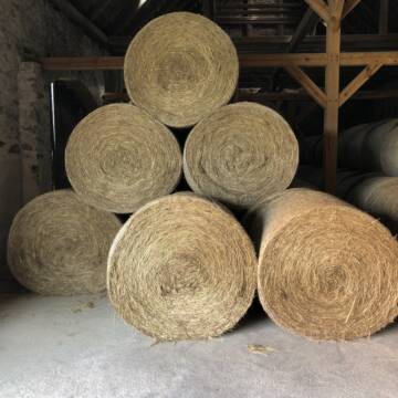
Pferdeheu 1.Schnitt Juli 2025/Rundballen 1.50m
Cavertitz
LWB Streubel
@Landwirtschaftsbetr.-Streubel
Heu
Lieferant entlädt
Rundballen
Bio
Regenfrei
3 weitere...
B+

Haferstroh 1.50m Ernte 25 Ausgezeichnete Qualität
Cavertitz
LWB Streubel
@Landwirtschaftsbetr.-Streubel
Stroh
Lieferant entlädt
Rundballen
Regenfrei
3 weitere...
B+
Deprecated: Creation of dynamic property Zend_View_Helper_Ads::$adLink is deprecated in /var/www/stall-frei/htdocs/staging.stall-frei.de/library/Psf/View/Helper/Ads.php on line 108

Futtersack HeuToy, Fressbremse in pink
Mechtersen
STALL-FREIde Marketing
@STALL-FREI-Marketing
Stundenlange Beschäftigung die
Koliken vorbeugt, geringe Staubinhalation mit
steuerbarer Futterentnahme


Futtermittel & Einstreu mit Lieferung!
Schwaara
MK-Agrarprodukte
@MK-Agrarprodukte
Heu
Empfänger lädt ab
Großballen
Regenfrei
2 weitere...
P+

Heu und Stroh /Rundballen/Quaderballen
Sandersdorf
jule13
@Jule2024
Stroh
Lieferant entlädt
Rundballen
Regenfrei
3 weitere...
B+

Luzerneheu 1.Schnitt
Teutschenthal
Nancy
@Haltergemeinschaft-TT
Heu
Empfänger lädt ab
Rundballen
Regenfrei
2 weitere...
B+
Leider kein Vorschaubild
Leider kein Vorschaubild
BIO-Heu, 1. Schnitt 2025, Quaderballen (60x40x30)
Tirpersdorf
Forstbaumschule
@Forstbaumschule
Heu
Kleinballen/HD-Ballen
Bio
Regenfrei
Wird verladen
1 weitere...
B+
Leider kein Vorschaubild
Leider kein Vorschaubild
BIO-Heu, 1. Schnitt 2024, Quaderballen (60x40x30)
Tirpersdorf
Forstbaumschule
@Forstbaumschule
Heu
Kleinballen/HD-Ballen
Bio
Regenfrei
Käufer lädt selbst
1 weitere...
aktuell
B+

Leider kein Vorschaubild
Leider kein Vorschaubild
Bio-Heu, 1. Schnitt aus 2024 (BIOLAND) zu verkauf.
Tirpersdorf
Forstbaumschule
@Forstbaumschule
Heu
Empfänger lädt ab
Großballen
Bio
Regenfrei
2 weitere...
B+
Leider kein Vorschaubild
Leider kein Vorschaubild
Heu zu verkaufen
Kremmen OT Staffelde
Rhinland Reitpark GmbH
@Rhinland-Reitpark
Heu
Empfänger lädt ab
Rundballen
Regenfrei
3 weitere...
B+

Haferstroh in Futterqualität für gesunde Pferde ...
Schollene
Guthof Mühlenfels
@Gutshof-Muehlenfels
Einstreu
Lieferant entlädt
Großballen
Regenfrei
3 weitere...
B+
Deprecated: Creation of dynamic property Zend_View::$pageCount is deprecated in /var/www/stall-frei/htdocs/staging.stall-frei.de/library/vendor/shardj/zf1-future/library/Zend/View/Abstract.php on line 308
Deprecated: Creation of dynamic property Zend_View::$itemCountPerPage is deprecated in /var/www/stall-frei/htdocs/staging.stall-frei.de/library/vendor/shardj/zf1-future/library/Zend/View/Abstract.php on line 308
Deprecated: Creation of dynamic property Zend_View::$first is deprecated in /var/www/stall-frei/htdocs/staging.stall-frei.de/library/vendor/shardj/zf1-future/library/Zend/View/Abstract.php on line 308
Deprecated: Creation of dynamic property Zend_View::$current is deprecated in /var/www/stall-frei/htdocs/staging.stall-frei.de/library/vendor/shardj/zf1-future/library/Zend/View/Abstract.php on line 308
Deprecated: Creation of dynamic property Zend_View::$last is deprecated in /var/www/stall-frei/htdocs/staging.stall-frei.de/library/vendor/shardj/zf1-future/library/Zend/View/Abstract.php on line 308
Deprecated: Creation of dynamic property Zend_View::$next is deprecated in /var/www/stall-frei/htdocs/staging.stall-frei.de/library/vendor/shardj/zf1-future/library/Zend/View/Abstract.php on line 308
Deprecated: Creation of dynamic property Zend_View::$pagesInRange is deprecated in /var/www/stall-frei/htdocs/staging.stall-frei.de/library/vendor/shardj/zf1-future/library/Zend/View/Abstract.php on line 308
Deprecated: Creation of dynamic property Zend_View::$firstPageInRange is deprecated in /var/www/stall-frei/htdocs/staging.stall-frei.de/library/vendor/shardj/zf1-future/library/Zend/View/Abstract.php on line 308
Deprecated: Creation of dynamic property Zend_View::$lastPageInRange is deprecated in /var/www/stall-frei/htdocs/staging.stall-frei.de/library/vendor/shardj/zf1-future/library/Zend/View/Abstract.php on line 308
Deprecated: Creation of dynamic property Zend_View::$currentItemCount is deprecated in /var/www/stall-frei/htdocs/staging.stall-frei.de/library/vendor/shardj/zf1-future/library/Zend/View/Abstract.php on line 308
Deprecated: Creation of dynamic property Zend_View::$totalItemCount is deprecated in /var/www/stall-frei/htdocs/staging.stall-frei.de/library/vendor/shardj/zf1-future/library/Zend/View/Abstract.php on line 308
Deprecated: Creation of dynamic property Zend_View::$firstItemNumber is deprecated in /var/www/stall-frei/htdocs/staging.stall-frei.de/library/vendor/shardj/zf1-future/library/Zend/View/Abstract.php on line 308
Deprecated: Creation of dynamic property Zend_View::$lastItemNumber is deprecated in /var/www/stall-frei/htdocs/staging.stall-frei.de/library/vendor/shardj/zf1-future/library/Zend/View/Abstract.php on line 308
Deprecated: Creation of dynamic property Zend_View::$router is deprecated in /var/www/stall-frei/htdocs/staging.stall-frei.de/library/vendor/shardj/zf1-future/library/Zend/View/Abstract.php on line 308
Deprecated: Creation of dynamic property Zend_View::$urlParams is deprecated in /var/www/stall-frei/htdocs/staging.stall-frei.de/library/vendor/shardj/zf1-future/library/Zend/View/Abstract.php on line 308
Deprecated: Creation of dynamic property Zend_View::$showAds is deprecated in /var/www/stall-frei/htdocs/staging.stall-frei.de/library/vendor/shardj/zf1-future/library/Zend/View/Abstract.php on line 308
Deprecated: Creation of dynamic property Zend_View::$objectIds is deprecated in /var/www/stall-frei/htdocs/staging.stall-frei.de/library/vendor/shardj/zf1-future/library/Zend/View/Abstract.php on line 308
Deprecated: Creation of dynamic property Zend_View::$showNavbar is deprecated in /var/www/stall-frei/htdocs/staging.stall-frei.de/library/vendor/shardj/zf1-future/library/Zend/View/Abstract.php on line 308
Deprecated: Creation of dynamic property Zend_View::$showBreadcrumb is deprecated in /var/www/stall-frei/htdocs/staging.stall-frei.de/library/vendor/shardj/zf1-future/library/Zend/View/Abstract.php on line 308
Deprecated: Creation of dynamic property Zend_View::$showFooter is deprecated in /var/www/stall-frei/htdocs/staging.stall-frei.de/library/vendor/shardj/zf1-future/library/Zend/View/Abstract.php on line 308
Deprecated: Creation of dynamic property Zend_View::$showInternalAds is deprecated in /var/www/stall-frei/htdocs/staging.stall-frei.de/library/vendor/shardj/zf1-future/library/Zend/View/Abstract.php on line 308
Deprecated: Creation of dynamic property Zend_View::$blNoContent is deprecated in /var/www/stall-frei/htdocs/staging.stall-frei.de/library/vendor/shardj/zf1-future/library/Zend/View/Abstract.php on line 308
Deprecated: Creation of dynamic property Zend_View::$sMetaDesc is deprecated in /var/www/stall-frei/htdocs/staging.stall-frei.de/library/vendor/shardj/zf1-future/library/Zend/View/Abstract.php on line 308
Deprecated: Creation of dynamic property Zend_View::$useGmaps is deprecated in /var/www/stall-frei/htdocs/staging.stall-frei.de/library/vendor/shardj/zf1-future/library/Zend/View/Abstract.php on line 308
Deprecated: Creation of dynamic property Zend_View::$touches is deprecated in /var/www/stall-frei/htdocs/staging.stall-frei.de/library/vendor/shardj/zf1-future/library/Zend/View/Abstract.php on line 308
Deprecated: Creation of dynamic property Zend_View::$oProject is deprecated in /var/www/stall-frei/htdocs/staging.stall-frei.de/library/vendor/shardj/zf1-future/library/Zend/View/Abstract.php on line 308
Deprecated: Creation of dynamic property Zend_View::$pageHeadline is deprecated in /var/www/stall-frei/htdocs/staging.stall-frei.de/library/vendor/shardj/zf1-future/library/Zend/View/Abstract.php on line 308
Deprecated: Creation of dynamic property Zend_View::$disableLocationField is deprecated in /var/www/stall-frei/htdocs/staging.stall-frei.de/library/vendor/shardj/zf1-future/library/Zend/View/Abstract.php on line 308
Deprecated: Creation of dynamic property Zend_View::$isSearch is deprecated in /var/www/stall-frei/htdocs/staging.stall-frei.de/library/vendor/shardj/zf1-future/library/Zend/View/Abstract.php on line 308
Deprecated: Creation of dynamic property Zend_View::$pageTitle is deprecated in /var/www/stall-frei/htdocs/staging.stall-frei.de/library/vendor/shardj/zf1-future/library/Zend/View/Abstract.php on line 308
Deprecated: Creation of dynamic property Psf_Form_Element_Text::$class is deprecated in /var/www/stall-frei/htdocs/staging.stall-frei.de/library/vendor/shardj/zf1-future/library/Zend/Form/Element.php on line 874
Deprecated: Creation of dynamic property Psf_Form_Element_Text::$size is deprecated in /var/www/stall-frei/htdocs/staging.stall-frei.de/library/vendor/shardj/zf1-future/library/Zend/Form/Element.php on line 874
Deprecated: Creation of dynamic property Psf_Form_Element_Text::$placeholder is deprecated in /var/www/stall-frei/htdocs/staging.stall-frei.de/library/vendor/shardj/zf1-future/library/Zend/Form/Element.php on line 874
Deprecated: Creation of dynamic property Psf_Form_Element_Hidden::$class is deprecated in /var/www/stall-frei/htdocs/staging.stall-frei.de/library/vendor/shardj/zf1-future/library/Zend/Form/Element.php on line 874
Deprecated: Creation of dynamic property Psf_Form_Element_Hidden::$class is deprecated in /var/www/stall-frei/htdocs/staging.stall-frei.de/library/vendor/shardj/zf1-future/library/Zend/Form/Element.php on line 874
Deprecated: Creation of dynamic property Psf_Form_Element_Hidden::$class is deprecated in /var/www/stall-frei/htdocs/staging.stall-frei.de/library/vendor/shardj/zf1-future/library/Zend/Form/Element.php on line 874
Deprecated: Creation of dynamic property Psf_Form_Element_Hidden::$class is deprecated in /var/www/stall-frei/htdocs/staging.stall-frei.de/library/vendor/shardj/zf1-future/library/Zend/Form/Element.php on line 874
Deprecated: Creation of dynamic property Psf_Form_Element_Select::$class is deprecated in /var/www/stall-frei/htdocs/staging.stall-frei.de/library/vendor/shardj/zf1-future/library/Zend/Form/Element.php on line 874
Deprecated: Creation of dynamic property Psf_Form_Element_Select::$class is deprecated in /var/www/stall-frei/htdocs/staging.stall-frei.de/library/vendor/shardj/zf1-future/library/Zend/Form/Element.php on line 874
Deprecated: Creation of dynamic property Psf_Form_Element_Select::$class is deprecated in /var/www/stall-frei/htdocs/staging.stall-frei.de/library/vendor/shardj/zf1-future/library/Zend/Form/Element.php on line 874
Deprecated: Creation of dynamic property Psf_Form_Element_Select::$class is deprecated in /var/www/stall-frei/htdocs/staging.stall-frei.de/library/vendor/shardj/zf1-future/library/Zend/Form/Element.php on line 874
Deprecated: Creation of dynamic property Zend_View::$sort is deprecated in /var/www/stall-frei/htdocs/staging.stall-frei.de/library/vendor/shardj/zf1-future/library/Zend/View/Abstract.php on line 308
Deprecated: Creation of dynamic property Zend_View::$searchLocation is deprecated in /var/www/stall-frei/htdocs/staging.stall-frei.de/library/vendor/shardj/zf1-future/library/Zend/View/Abstract.php on line 308
Deprecated: Creation of dynamic property Zend_View::$locationHint is deprecated in /var/www/stall-frei/htdocs/staging.stall-frei.de/library/vendor/shardj/zf1-future/library/Zend/View/Abstract.php on line 308
Psf_GeoCoder_Abstract::getLocation: Naundorf Get Location CachedOrLive
Psf_GeoCoder_Abstract::getCachedOrLive: Naundorf
Psf_GeoCoder_OpenCageData::makeApiRequest: response:
Array
(
[documentation] => https://opencagedata.com/api
[licenses] => Array
(
[0] => Array
(
[name] => see attribution guide
[url] => https://opencagedata.com/credits
)
)
[results] => Array
(
[0] => Array
(
[bounds] => Array
(
[northeast] => Array
(
[lat] => 51.2790689
[lng] => 13.2172918
)
[southwest] => Array
(
[lat] => 51.2194379
[lng] => 13.0884809
)
)
[components] => Array
(
[ISO_3166-1_alpha-2] => DE
[ISO_3166-1_alpha-3] => DEU
[ISO_3166-2] => Array
(
[0] => DE-SN
)
[_category] => place
[_normalized_city] => Naundorf
[_type] => village
[continent] => Europe
[country] => Deutschland
[country_code] => de
[county] => Nordsachsen
[political_union] => European Union
[state] => Sachsen
[state_code] => SN
[village] => Naundorf
)
[confidence] => 7
[formatted] => Naundorf, Sachsen, Deutschland
[geometry] => Array
(
[lat] => 51.2601621
[lng] => 13.1876528
)
)
[1] => Array
(
[bounds] => Array
(
[northeast] => Array
(
[lat] => 51.1345128
[lng] => 13.6327518
)
[southwest] => Array
(
[lat] => 51.1037188
[lng] => 13.5853138
)
)
[components] => Array
(
[ISO_3166-1_alpha-2] => DE
[ISO_3166-1_alpha-3] => DEU
[ISO_3166-2] => Array
(
[0] => DE-SN
)
[_category] => place
[_normalized_city] => Radebeul
[_type] => neighbourhood
[continent] => Europe
[country] => Deutschland
[country_code] => de
[county] => Meißen
[political_union] => European Union
[state] => Sachsen
[state_code] => SN
[suburb] => Naundorf
[town] => Radebeul
)
[confidence] => 7
[formatted] => Naundorf, Radebeul, Sachsen, Deutschland
[geometry] => Array
(
[lat] => 51.1114741
[lng] => 13.6064198
)
)
[2] => Array
(
[bounds] => Array
(
[northeast] => Array
(
[lat] => 51.2284002
[lng] => 12.8180727
)
[southwest] => Array
(
[lat] => 51.1884002
[lng] => 12.7780727
)
)
[components] => Array
(
[ISO_3166-1_alpha-2] => DE
[ISO_3166-1_alpha-3] => DEU
[ISO_3166-2] => Array
(
[0] => DE-SN
)
[_category] => place
[_normalized_city] => Grimma
[_type] => hamlet
[city_district] => Höfgen
[continent] => Europe
[country] => Deutschland
[country_code] => de
[county] => Landkreis Leipzig
[hamlet] => Naundorf
[political_union] => European Union
[state] => Sachsen
[state_code] => SN
[town] => Grimma
)
[confidence] => 7
[formatted] => Naundorf, Höfgen, Grimma, Sachsen, Deutschland
[geometry] => Array
(
[lat] => 51.2084002
[lng] => 12.7980727
)
)
[3] => Array
(
[bounds] => Array
(
[northeast] => Array
(
[lat] => 50.95724
[lng] => 13.4378293
)
[southwest] => Array
(
[lat] => 50.91724
[lng] => 13.3978293
)
)
[components] => Array
(
[ISO_3166-1_alpha-2] => DE
[ISO_3166-1_alpha-3] => DEU
[ISO_3166-2] => Array
(
[0] => DE-SN
)
[_category] => place
[_normalized_city] => Bobritzsch-Hilbersdorf
[_type] => village
[city] => Bobritzsch-Hilbersdorf
[continent] => Europe
[country] => Deutschland
[country_code] => de
[county] => Mittelsachsen
[political_union] => European Union
[postcode] => 09633
[state] => Sachsen
[state_code] => SN
[village] => Naundorf
)
[confidence] => 7
[formatted] => 09633 Naundorf, Deutschland
[geometry] => Array
(
[lat] => 50.93724
[lng] => 13.4178293
)
)
[4] => Array
(
[bounds] => Array
(
[northeast] => Array
(
[lat] => 50.9966816
[lng] => 12.2847171
)
[southwest] => Array
(
[lat] => 50.9566816
[lng] => 12.2447171
)
)
[components] => Array
(
[ISO_3166-1_alpha-2] => DE
[ISO_3166-1_alpha-3] => DEU
[ISO_3166-2] => Array
(
[0] => DE-TH
)
[_category] => place
[_normalized_city] => Starkenberg
[_type] => village
[city] => Starkenberg
[continent] => Europe
[country] => Deutschland
[country_code] => de
[county] => Altenburger Land
[municipality] => Rositz
[political_union] => European Union
[state] => Thüringen
[state_code] => TH
[village] => Naundorf
)
[confidence] => 7
[formatted] => Naundorf, Thüringen, Deutschland
[geometry] => Array
(
[lat] => 50.9766816
[lng] => 12.2647171
)
)
[5] => Array
(
[bounds] => Array
(
[northeast] => Array
(
[lat] => 50.9673863
[lng] => 14.0478175
)
[southwest] => Array
(
[lat] => 50.9273863
[lng] => 14.0078175
)
)
[components] => Array
(
[ISO_3166-1_alpha-2] => DE
[ISO_3166-1_alpha-3] => DEU
[ISO_3166-2] => Array
(
[0] => DE-SN
)
[_category] => place
[_normalized_city] => Struppen
[_type] => village
[city] => Struppen
[continent] => Europe
[country] => Deutschland
[country_code] => de
[county] => Sächsische Schweiz-Osterzgebirge
[municipality] => Königstein/Sächs. Schw.
[political_union] => European Union
[postcode] => 01829
[state] => Sachsen
[state_code] => SN
[village] => Naundorf
)
[confidence] => 7
[formatted] => 01829 Naundorf, Deutschland
[geometry] => Array
(
[lat] => 50.9473863
[lng] => 14.0278175
)
)
[6] => Array
(
[bounds] => Array
(
[northeast] => Array
(
[lat] => 51.1907469
[lng] => 12.9760562
)
[southwest] => Array
(
[lat] => 51.1507469
[lng] => 12.9360562
)
)
[components] => Array
(
[ISO_3166-1_alpha-2] => DE
[ISO_3166-1_alpha-3] => DEU
[ISO_3166-2] => Array
(
[0] => DE-SN
)
[_category] => place
[_normalized_city] => Leisnig
[_type] => village
[continent] => Europe
[country] => Deutschland
[country_code] => de
[county] => Mittelsachsen
[political_union] => European Union
[postcode] => 04703
[state] => Sachsen
[state_code] => SN
[town] => Leisnig
[village] => Naundorf
)
[confidence] => 7
[formatted] => 04703 Naundorf, Deutschland
[geometry] => Array
(
[lat] => 51.1707469
[lng] => 12.9560562
)
)
[7] => Array
(
[bounds] => Array
(
[northeast] => Array
(
[lat] => 51.840173
[lng] => 14.1202356
)
[southwest] => Array
(
[lat] => 51.800173
[lng] => 14.0802356
)
)
[components] => Array
(
[ISO_3166-1_alpha-2] => DE
[ISO_3166-1_alpha-3] => DEU
[ISO_3166-2] => Array
(
[0] => DE-BB
)
[_category] => place
[_normalized_city] => Vetschau/Spreewald
[_type] => village
[continent] => Europe
[country] => Deutschland
[country_code] => de
[county] => Oberspreewald-Lausitz
[political_union] => European Union
[postcode] => 03226
[state] => Brandenburg
[state_code] => BB
[town] => Vetschau/Spreewald
[village] => Naundorf
)
[confidence] => 7
[formatted] => 03226 Naundorf, Deutschland
[geometry] => Array
(
[lat] => 51.820173
[lng] => 14.1002356
)
)
[8] => Array
(
[bounds] => Array
(
[northeast] => Array
(
[lat] => 51.5192794
[lng] => 13.8171973
)
[southwest] => Array
(
[lat] => 51.4792794
[lng] => 13.7771973
)
)
[components] => Array
(
[ISO_3166-1_alpha-2] => DE
[ISO_3166-1_alpha-3] => DEU
[ISO_3166-2] => Array
(
[0] => DE-BB
)
[_category] => place
[_normalized_city] => Lauchhammer
[_type] => neighbourhood
[continent] => Europe
[country] => Deutschland
[country_code] => de
[county] => Oberspreewald-Lausitz
[municipality] => Lauchhammer
[political_union] => European Union
[postcode] => 01979
[state] => Brandenburg
[state_code] => BB
[suburb] => Lauchhammer-Ost
[town] => Lauchhammer
)
[confidence] => 7
[formatted] => 01979 Lauchhammer, Deutschland
[geometry] => Array
(
[lat] => 51.4992794
[lng] => 13.7971973
)
)
[9] => Array
(
[bounds] => Array
(
[northeast] => Array
(
[lat] => 50.8614398
[lng] => 13.6818969
)
[southwest] => Array
(
[lat] => 50.8214398
[lng] => 13.6418969
)
)
[components] => Array
(
[ISO_3166-1_alpha-2] => DE
[ISO_3166-1_alpha-3] => DEU
[ISO_3166-2] => Array
(
[0] => DE-SN
)
[_category] => place
[_normalized_city] => Dippoldiswalde
[_type] => village
[continent] => Europe
[country] => Deutschland
[country_code] => de
[county] => Sächsische Schweiz-Osterzgebirge
[political_union] => European Union
[postcode] => 01744
[state] => Sachsen
[state_code] => SN
[town] => Dippoldiswalde
[village] => Naundorf
)
[confidence] => 7
[formatted] => 01744 Naundorf, Deutschland
[geometry] => Array
(
[lat] => 50.8414398
[lng] => 13.6618969
)
)
)
[status] => Array
(
[code] => 200
[message] => OK
)
[stay_informed] => Array
(
[blog] => https://blog.opencagedata.com
[mastodon] => https://en.osm.town/@opencage
)
[thanks] => For using an OpenCage API
[timestamp] => Array
(
[created_http] => Sat, 07 Feb 2026 13:27:15 GMT
[created_unix] => 1770470835
)
[total_results] => 10
)
Psf_GeoCoder_Abstract::convertLocationResult
{"documentation":"https:\/\/opencagedata.com\/api","licenses":[{"name":"see attribution guide","url":"https:\/\/opencagedata.com\/credits"}],"results":[{"bounds":{"northeast":{"lat":51.2790689,"lng":13.2172918},"southwest":{"lat":51.2194379,"lng":13.0884809}},"components":{"ISO_3166-1_alpha-2":"DE","ISO_3166-1_alpha-3":"DEU","ISO_3166-2":["DE-SN"],"_category":"place","_normalized_city":"Naundorf","_type":"village","continent":"Europe","country":"Deutschland","country_code":"de","county":"Nordsachsen","political_union":"European Union","state":"Sachsen","state_code":"SN","village":"Naundorf"},"confidence":7,"formatted":"Naundorf, Sachsen, Deutschland","geometry":{"lat":51.2601621,"lng":13.1876528}},{"bounds":{"northeast":{"lat":51.1345128,"lng":13.6327518},"southwest":{"lat":51.1037188,"lng":13.5853138}},"components":{"ISO_3166-1_alpha-2":"DE","ISO_3166-1_alpha-3":"DEU","ISO_3166-2":["DE-SN"],"_category":"place","_normalized_city":"Radebeul","_type":"neighbourhood","continent":"Europe","country":"Deutschland","country_code":"de","county":"Mei\u00dfen","political_union":"European Union","state":"Sachsen","state_code":"SN","suburb":"Naundorf","town":"Radebeul"},"confidence":7,"formatted":"Naundorf, Radebeul, Sachsen, Deutschland","geometry":{"lat":51.1114741,"lng":13.6064198}},{"bounds":{"northeast":{"lat":51.2284002,"lng":12.8180727},"southwest":{"lat":51.1884002,"lng":12.7780727}},"components":{"ISO_3166-1_alpha-2":"DE","ISO_3166-1_alpha-3":"DEU","ISO_3166-2":["DE-SN"],"_category":"place","_normalized_city":"Grimma","_type":"hamlet","city_district":"H\u00f6fgen","continent":"Europe","country":"Deutschland","country_code":"de","county":"Landkreis Leipzig","hamlet":"Naundorf","political_union":"European Union","state":"Sachsen","state_code":"SN","town":"Grimma"},"confidence":7,"formatted":"Naundorf, H\u00f6fgen, Grimma, Sachsen, Deutschland","geometry":{"lat":51.2084002,"lng":12.7980727}},{"bounds":{"northeast":{"lat":50.95724,"lng":13.4378293},"southwest":{"lat":50.91724,"lng":13.3978293}},"components":{"ISO_3166-1_alpha-2":"DE","ISO_3166-1_alpha-3":"DEU","ISO_3166-2":["DE-SN"],"_category":"place","_normalized_city":"Bobritzsch-Hilbersdorf","_type":"village","city":"Bobritzsch-Hilbersdorf","continent":"Europe","country":"Deutschland","country_code":"de","county":"Mittelsachsen","political_union":"European Union","postcode":"09633","state":"Sachsen","state_code":"SN","village":"Naundorf"},"confidence":7,"formatted":"09633 Naundorf, Deutschland","geometry":{"lat":50.93724,"lng":13.4178293}},{"bounds":{"northeast":{"lat":50.9966816,"lng":12.2847171},"southwest":{"lat":50.9566816,"lng":12.2447171}},"components":{"ISO_3166-1_alpha-2":"DE","ISO_3166-1_alpha-3":"DEU","ISO_3166-2":["DE-TH"],"_category":"place","_normalized_city":"Starkenberg","_type":"village","city":"Starkenberg","continent":"Europe","country":"Deutschland","country_code":"de","county":"Altenburger Land","municipality":"Rositz","political_union":"European Union","state":"Th\u00fcringen","state_code":"TH","village":"Naundorf"},"confidence":7,"formatted":"Naundorf, Th\u00fcringen, Deutschland","geometry":{"lat":50.9766816,"lng":12.2647171}},{"bounds":{"northeast":{"lat":50.9673863,"lng":14.0478175},"southwest":{"lat":50.9273863,"lng":14.0078175}},"components":{"ISO_3166-1_alpha-2":"DE","ISO_3166-1_alpha-3":"DEU","ISO_3166-2":["DE-SN"],"_category":"place","_normalized_city":"Struppen","_type":"village","city":"Struppen","continent":"Europe","country":"Deutschland","country_code":"de","county":"S\u00e4chsische Schweiz-Osterzgebirge","municipality":"K\u00f6nigstein\/S\u00e4chs. Schw.","political_union":"European Union","postcode":"01829","state":"Sachsen","state_code":"SN","village":"Naundorf"},"confidence":7,"formatted":"01829 Naundorf, Deutschland","geometry":{"lat":50.9473863,"lng":14.0278175}},{"bounds":{"northeast":{"lat":51.1907469,"lng":12.9760562},"southwest":{"lat":51.1507469,"lng":12.9360562}},"components":{"ISO_3166-1_alpha-2":"DE","ISO_3166-1_alpha-3":"DEU","ISO_3166-2":["DE-SN"],"_category":"place","_normalized_city":"Leisnig","_type":"village","continent":"Europe","country":"Deutschland","country_code":"de","county":"Mittelsachsen","political_union":"European Union","postcode":"04703","state":"Sachsen","state_code":"SN","town":"Leisnig","village":"Naundorf"},"confidence":7,"formatted":"04703 Naundorf, Deutschland","geometry":{"lat":51.1707469,"lng":12.9560562}},{"bounds":{"northeast":{"lat":51.840173,"lng":14.1202356},"southwest":{"lat":51.800173,"lng":14.0802356}},"components":{"ISO_3166-1_alpha-2":"DE","ISO_3166-1_alpha-3":"DEU","ISO_3166-2":["DE-BB"],"_category":"place","_normalized_city":"Vetschau\/Spreewald","_type":"village","continent":"Europe","country":"Deutschland","country_code":"de","county":"Oberspreewald-Lausitz","political_union":"European Union","postcode":"03226","state":"Brandenburg","state_code":"BB","town":"Vetschau\/Spreewald","village":"Naundorf"},"confidence":7,"formatted":"03226 Naundorf, Deutschland","geometry":{"lat":51.820173,"lng":14.1002356}},{"bounds":{"northeast":{"lat":51.5192794,"lng":13.8171973},"southwest":{"lat":51.4792794,"lng":13.7771973}},"components":{"ISO_3166-1_alpha-2":"DE","ISO_3166-1_alpha-3":"DEU","ISO_3166-2":["DE-BB"],"_category":"place","_normalized_city":"Lauchhammer","_type":"neighbourhood","continent":"Europe","country":"Deutschland","country_code":"de","county":"Oberspreewald-Lausitz","municipality":"Lauchhammer","political_union":"European Union","postcode":"01979","state":"Brandenburg","state_code":"BB","suburb":"Lauchhammer-Ost","town":"Lauchhammer"},"confidence":7,"formatted":"01979 Lauchhammer, Deutschland","geometry":{"lat":51.4992794,"lng":13.7971973}},{"bounds":{"northeast":{"lat":50.8614398,"lng":13.6818969},"southwest":{"lat":50.8214398,"lng":13.6418969}},"components":{"ISO_3166-1_alpha-2":"DE","ISO_3166-1_alpha-3":"DEU","ISO_3166-2":["DE-SN"],"_category":"place","_normalized_city":"Dippoldiswalde","_type":"village","continent":"Europe","country":"Deutschland","country_code":"de","county":"S\u00e4chsische Schweiz-Osterzgebirge","political_union":"European Union","postcode":"01744","state":"Sachsen","state_code":"SN","town":"Dippoldiswalde","village":"Naundorf"},"confidence":7,"formatted":"01744 Naundorf, Deutschland","geometry":{"lat":50.8414398,"lng":13.6618969}}],"status":{"code":200,"message":"OK"},"stay_informed":{"blog":"https:\/\/blog.opencagedata.com","mastodon":"https:\/\/en.osm.town\/@opencage"},"thanks":"For using an OpenCage API","timestamp":{"created_http":"Sat, 07 Feb 2026 13:27:15 GMT","created_unix":1770470835},"total_results":10}Array
(
[0] => stdClass Object
(
[bounds] => stdClass Object
(
[northeast] => stdClass Object
(
[lat] => 51.2790689
[lng] => 13.2172918
)
[southwest] => stdClass Object
(
[lat] => 51.2194379
[lng] => 13.0884809
)
)
[components] => stdClass Object
(
[ISO_3166-1_alpha-2] => DE
[ISO_3166-1_alpha-3] => DEU
[ISO_3166-2] => Array
(
[0] => DE-SN
)
[_category] => place
[_normalized_city] => Naundorf
[_type] => village
[continent] => Europe
[country] => Deutschland
[country_code] => de
[county] => Nordsachsen
[political_union] => European Union
[state] => Sachsen
[state_code] => SN
[village] => Naundorf
)
[confidence] => 7
[formatted] => Naundorf, Sachsen, Deutschland
[geometry] => stdClass Object
(
[lat] => 51.2601621
[lng] => 13.1876528
)
)
[1] => stdClass Object
(
[bounds] => stdClass Object
(
[northeast] => stdClass Object
(
[lat] => 51.1345128
[lng] => 13.6327518
)
[southwest] => stdClass Object
(
[lat] => 51.1037188
[lng] => 13.5853138
)
)
[components] => stdClass Object
(
[ISO_3166-1_alpha-2] => DE
[ISO_3166-1_alpha-3] => DEU
[ISO_3166-2] => Array
(
[0] => DE-SN
)
[_category] => place
[_normalized_city] => Radebeul
[_type] => neighbourhood
[continent] => Europe
[country] => Deutschland
[country_code] => de
[county] => Meißen
[political_union] => European Union
[state] => Sachsen
[state_code] => SN
[suburb] => Naundorf
[town] => Radebeul
)
[confidence] => 7
[formatted] => Naundorf, Radebeul, Sachsen, Deutschland
[geometry] => stdClass Object
(
[lat] => 51.1114741
[lng] => 13.6064198
)
)
[2] => stdClass Object
(
[bounds] => stdClass Object
(
[northeast] => stdClass Object
(
[lat] => 51.2284002
[lng] => 12.8180727
)
[southwest] => stdClass Object
(
[lat] => 51.1884002
[lng] => 12.7780727
)
)
[components] => stdClass Object
(
[ISO_3166-1_alpha-2] => DE
[ISO_3166-1_alpha-3] => DEU
[ISO_3166-2] => Array
(
[0] => DE-SN
)
[_category] => place
[_normalized_city] => Grimma
[_type] => hamlet
[city_district] => Höfgen
[continent] => Europe
[country] => Deutschland
[country_code] => de
[county] => Landkreis Leipzig
[hamlet] => Naundorf
[political_union] => European Union
[state] => Sachsen
[state_code] => SN
[town] => Grimma
)
[confidence] => 7
[formatted] => Naundorf, Höfgen, Grimma, Sachsen, Deutschland
[geometry] => stdClass Object
(
[lat] => 51.2084002
[lng] => 12.7980727
)
)
[3] => stdClass Object
(
[bounds] => stdClass Object
(
[northeast] => stdClass Object
(
[lat] => 50.95724
[lng] => 13.4378293
)
[southwest] => stdClass Object
(
[lat] => 50.91724
[lng] => 13.3978293
)
)
[components] => stdClass Object
(
[ISO_3166-1_alpha-2] => DE
[ISO_3166-1_alpha-3] => DEU
[ISO_3166-2] => Array
(
[0] => DE-SN
)
[_category] => place
[_normalized_city] => Bobritzsch-Hilbersdorf
[_type] => village
[city] => Bobritzsch-Hilbersdorf
[continent] => Europe
[country] => Deutschland
[country_code] => de
[county] => Mittelsachsen
[political_union] => European Union
[postcode] => 09633
[state] => Sachsen
[state_code] => SN
[village] => Naundorf
)
[confidence] => 7
[formatted] => 09633 Naundorf, Deutschland
[geometry] => stdClass Object
(
[lat] => 50.93724
[lng] => 13.4178293
)
)
[4] => stdClass Object
(
[bounds] => stdClass Object
(
[northeast] => stdClass Object
(
[lat] => 50.9966816
[lng] => 12.2847171
)
[southwest] => stdClass Object
(
[lat] => 50.9566816
[lng] => 12.2447171
)
)
[components] => stdClass Object
(
[ISO_3166-1_alpha-2] => DE
[ISO_3166-1_alpha-3] => DEU
[ISO_3166-2] => Array
(
[0] => DE-TH
)
[_category] => place
[_normalized_city] => Starkenberg
[_type] => village
[city] => Starkenberg
[continent] => Europe
[country] => Deutschland
[country_code] => de
[county] => Altenburger Land
[municipality] => Rositz
[political_union] => European Union
[state] => Thüringen
[state_code] => TH
[village] => Naundorf
)
[confidence] => 7
[formatted] => Naundorf, Thüringen, Deutschland
[geometry] => stdClass Object
(
[lat] => 50.9766816
[lng] => 12.2647171
)
)
[5] => stdClass Object
(
[bounds] => stdClass Object
(
[northeast] => stdClass Object
(
[lat] => 50.9673863
[lng] => 14.0478175
)
[southwest] => stdClass Object
(
[lat] => 50.9273863
[lng] => 14.0078175
)
)
[components] => stdClass Object
(
[ISO_3166-1_alpha-2] => DE
[ISO_3166-1_alpha-3] => DEU
[ISO_3166-2] => Array
(
[0] => DE-SN
)
[_category] => place
[_normalized_city] => Struppen
[_type] => village
[city] => Struppen
[continent] => Europe
[country] => Deutschland
[country_code] => de
[county] => Sächsische Schweiz-Osterzgebirge
[municipality] => Königstein/Sächs. Schw.
[political_union] => European Union
[postcode] => 01829
[state] => Sachsen
[state_code] => SN
[village] => Naundorf
)
[confidence] => 7
[formatted] => 01829 Naundorf, Deutschland
[geometry] => stdClass Object
(
[lat] => 50.9473863
[lng] => 14.0278175
)
)
[6] => stdClass Object
(
[bounds] => stdClass Object
(
[northeast] => stdClass Object
(
[lat] => 51.1907469
[lng] => 12.9760562
)
[southwest] => stdClass Object
(
[lat] => 51.1507469
[lng] => 12.9360562
)
)
[components] => stdClass Object
(
[ISO_3166-1_alpha-2] => DE
[ISO_3166-1_alpha-3] => DEU
[ISO_3166-2] => Array
(
[0] => DE-SN
)
[_category] => place
[_normalized_city] => Leisnig
[_type] => village
[continent] => Europe
[country] => Deutschland
[country_code] => de
[county] => Mittelsachsen
[political_union] => European Union
[postcode] => 04703
[state] => Sachsen
[state_code] => SN
[town] => Leisnig
[village] => Naundorf
)
[confidence] => 7
[formatted] => 04703 Naundorf, Deutschland
[geometry] => stdClass Object
(
[lat] => 51.1707469
[lng] => 12.9560562
)
)
[7] => stdClass Object
(
[bounds] => stdClass Object
(
[northeast] => stdClass Object
(
[lat] => 51.840173
[lng] => 14.1202356
)
[southwest] => stdClass Object
(
[lat] => 51.800173
[lng] => 14.0802356
)
)
[components] => stdClass Object
(
[ISO_3166-1_alpha-2] => DE
[ISO_3166-1_alpha-3] => DEU
[ISO_3166-2] => Array
(
[0] => DE-BB
)
[_category] => place
[_normalized_city] => Vetschau/Spreewald
[_type] => village
[continent] => Europe
[country] => Deutschland
[country_code] => de
[county] => Oberspreewald-Lausitz
[political_union] => European Union
[postcode] => 03226
[state] => Brandenburg
[state_code] => BB
[town] => Vetschau/Spreewald
[village] => Naundorf
)
[confidence] => 7
[formatted] => 03226 Naundorf, Deutschland
[geometry] => stdClass Object
(
[lat] => 51.820173
[lng] => 14.1002356
)
)
[8] => stdClass Object
(
[bounds] => stdClass Object
(
[northeast] => stdClass Object
(
[lat] => 51.5192794
[lng] => 13.8171973
)
[southwest] => stdClass Object
(
[lat] => 51.4792794
[lng] => 13.7771973
)
)
[components] => stdClass Object
(
[ISO_3166-1_alpha-2] => DE
[ISO_3166-1_alpha-3] => DEU
[ISO_3166-2] => Array
(
[0] => DE-BB
)
[_category] => place
[_normalized_city] => Lauchhammer
[_type] => neighbourhood
[continent] => Europe
[country] => Deutschland
[country_code] => de
[county] => Oberspreewald-Lausitz
[municipality] => Lauchhammer
[political_union] => European Union
[postcode] => 01979
[state] => Brandenburg
[state_code] => BB
[suburb] => Lauchhammer-Ost
[town] => Lauchhammer
)
[confidence] => 7
[formatted] => 01979 Lauchhammer, Deutschland
[geometry] => stdClass Object
(
[lat] => 51.4992794
[lng] => 13.7971973
)
)
[9] => stdClass Object
(
[bounds] => stdClass Object
(
[northeast] => stdClass Object
(
[lat] => 50.8614398
[lng] => 13.6818969
)
[southwest] => stdClass Object
(
[lat] => 50.8214398
[lng] => 13.6418969
)
)
[components] => stdClass Object
(
[ISO_3166-1_alpha-2] => DE
[ISO_3166-1_alpha-3] => DEU
[ISO_3166-2] => Array
(
[0] => DE-SN
)
[_category] => place
[_normalized_city] => Dippoldiswalde
[_type] => village
[continent] => Europe
[country] => Deutschland
[country_code] => de
[county] => Sächsische Schweiz-Osterzgebirge
[political_union] => European Union
[postcode] => 01744
[state] => Sachsen
[state_code] => SN
[town] => Dippoldiswalde
[village] => Naundorf
)
[confidence] => 7
[formatted] => 01744 Naundorf, Deutschland
[geometry] => stdClass Object
(
[lat] => 50.8414398
[lng] => 13.6618969
)
)
)
Psf_GeoCoder_OpenCageData::getKeyMap: 0
stdClass Object
(
    [bounds] => stdClass Object
        (
            [northeast] => stdClass Object
                (
                    [lat] => 51.2790689
                    [lng] => 13.2172918
                )

            [southwest] => stdClass Object
                (
                    [lat] => 51.2194379
                    [lng] => 13.0884809
                )

        )

    [components] => stdClass Object
        (
            [ISO_3166-1_alpha-2] => DE
            [ISO_3166-1_alpha-3] => DEU
            [ISO_3166-2] => Array
                (
                    [0] => DE-SN
                )

            [_category] => place
            [_normalized_city] => Naundorf
            [_type] => village
            [continent] => Europe
            [country] => Deutschland
            [country_code] => de
            [county] => Nordsachsen
            [political_union] => European Union
            [state] => Sachsen
            [state_code] => SN
            [village] => Naundorf
        )

    [confidence] => 7
    [formatted] => Naundorf, Sachsen, Deutschland
    [geometry] => stdClass Object
        (
            [lat] => 51.2601621
            [lng] => 13.1876528
        )

)
Psf_GeoCoder_OpenCageData::getCounty: Nordsachsen
Psf_GeoCoder_OpenCageData::addMissingData REFETCH!
Array
(
    [address] => Naundorf, Sachsen, Deutschland
    [type] => village
    [street] =>
    [city] => Naundorf
    [county] => Nordsachsen
    [state] => Sachsen
    [zip] =>
    [country] => Deutschland
    [suburb] =>
    [countrycode] => de
    [latitude] => 51.2601621
    [longitude] => 13.1876528
    [accuracy] => 1
    [confidence] => 7
    [bounds] => stdClass Object
        (
            [northeast] => stdClass Object
                (
                    [lat] => 51.2790689
                    [lng] => 13.2172918
                )

            [southwest] => stdClass Object
                (
                    [lat] => 51.2194379
                    [lng] => 13.0884809
                )

        )

)
reformat!
Array
(
    [address] => Naundorf, Sachsen, Deutschland
    [type] => village
    [street] =>
    [city] => Naundorf
    [county] => Nordsachsen
    [state] => Sachsen
    [zip] =>
    [country] => Deutschland
    [suburb] =>
    [countrycode] => de
    [latitude] => 51.2601621
    [longitude] => 13.1876528
    [accuracy] => 1
    [confidence] => 7
    [bounds] => stdClass Object
        (
            [northeast] => stdClass Object
                (
                    [lat] => 51.2790689
                    [lng] => 13.2172918
                )

            [southwest] => stdClass Object
                (
                    [lat] => 51.2194379
                    [lng] => 13.0884809
                )

        )

    [place] => Naundorf, Sachsen
    [hash] => 4d2fa3f1bc80350f74aa021aaa883249
)
Psf_GeoCoder_OpenCageData::getKeyMap: 1
stdClass Object
(
    [bounds] => stdClass Object
        (
            [northeast] => stdClass Object
                (
                    [lat] => 51.1345128
                    [lng] => 13.6327518
                )

            [southwest] => stdClass Object
                (
                    [lat] => 51.1037188
                    [lng] => 13.5853138
                )

        )

    [components] => stdClass Object
        (
            [ISO_3166-1_alpha-2] => DE
            [ISO_3166-1_alpha-3] => DEU
            [ISO_3166-2] => Array
                (
                    [0] => DE-SN
                )

            [_category] => place
            [_normalized_city] => Radebeul
            [_type] => neighbourhood
            [continent] => Europe
            [country] => Deutschland
            [country_code] => de
            [county] => Meißen
            [political_union] => European Union
            [state] => Sachsen
            [state_code] => SN
            [suburb] => Naundorf
            [town] => Radebeul
        )

    [confidence] => 7
    [formatted] => Naundorf, Radebeul, Sachsen, Deutschland
    [geometry] => stdClass Object
        (
            [lat] => 51.1114741
            [lng] => 13.6064198
        )

)
Psf_GeoCoder_OpenCageData::getCounty: Meißen
Psf_GeoCoder_OpenCageData::addMissingData REFETCH!
Array
(
    [address] => Naundorf, Radebeul, Sachsen, Deutschland
    [type] => neighbourhood
    [street] =>
    [city] => Radebeul
    [county] => Meißen
    [state] => Sachsen
    [zip] =>
    [country] => Deutschland
    [suburb] => Naundorf
    [countrycode] => de
    [latitude] => 51.1114741
    [longitude] => 13.6064198
    [accuracy] => 1
    [confidence] => 7
    [bounds] => stdClass Object
        (
            [northeast] => stdClass Object
                (
                    [lat] => 51.1345128
                    [lng] => 13.6327518
                )

            [southwest] => stdClass Object
                (
                    [lat] => 51.1037188
                    [lng] => 13.5853138
                )

        )

)
reformat!
Array
(
    [address] => Naundorf, Radebeul, Sachsen, Deutschland
    [type] => neighbourhood
    [street] =>
    [city] => Radebeul
    [county] => Meißen
    [state] => Sachsen
    [zip] =>
    [country] => Deutschland
    [suburb] => Naundorf
    [countrycode] => de
    [latitude] => 51.1114741
    [longitude] => 13.6064198
    [accuracy] => 1
    [confidence] => 7
    [bounds] => stdClass Object
        (
            [northeast] => stdClass Object
                (
                    [lat] => 51.1345128
                    [lng] => 13.6327518
                )

            [southwest] => stdClass Object
                (
                    [lat] => 51.1037188
                    [lng] => 13.5853138
                )

        )

    [place] => Radebeul, Sachsen
    [hash] => d35b06639fe1c61db377b1865dc6fe52
)
Psf_GeoCoder_OpenCageData::getKeyMap: 2
stdClass Object
(
    [bounds] => stdClass Object
        (
            [northeast] => stdClass Object
                (
                    [lat] => 51.2284002
                    [lng] => 12.8180727
                )

            [southwest] => stdClass Object
                (
                    [lat] => 51.1884002
                    [lng] => 12.7780727
                )

        )

    [components] => stdClass Object
        (
            [ISO_3166-1_alpha-2] => DE
            [ISO_3166-1_alpha-3] => DEU
            [ISO_3166-2] => Array
                (
                    [0] => DE-SN
                )

            [_category] => place
            [_normalized_city] => Grimma
            [_type] => hamlet
            [city_district] => Höfgen
            [continent] => Europe
            [country] => Deutschland
            [country_code] => de
            [county] => Landkreis Leipzig
            [hamlet] => Naundorf
            [political_union] => European Union
            [state] => Sachsen
            [state_code] => SN
            [town] => Grimma
        )

    [confidence] => 7
    [formatted] => Naundorf, Höfgen, Grimma, Sachsen, Deutschland
    [geometry] => stdClass Object
        (
            [lat] => 51.2084002
            [lng] => 12.7980727
        )

)
Psf_GeoCoder_OpenCageData::getCounty: Leipzig
Psf_GeoCoder_OpenCageData::addMissingData REFETCH!
Array
(
    [address] => Naundorf, Höfgen, Grimma, Sachsen, Deutschland
    [type] => hamlet
    [street] => Naundorf
    [city] => Grimma
    [county] => Leipzig
    [state] => Sachsen
    [zip] =>
    [country] => Deutschland
    [suburb] =>
    [countrycode] => de
    [latitude] => 51.2084002
    [longitude] => 12.7980727
    [accuracy] => 1
    [confidence] => 7
    [bounds] => stdClass Object
        (
            [northeast] => stdClass Object
                (
                    [lat] => 51.2284002
                    [lng] => 12.8180727
                )

            [southwest] => stdClass Object
                (
                    [lat] => 51.1884002
                    [lng] => 12.7780727
                )

        )

)
reformat!
Array
(
    [address] => Naundorf, Höfgen, Grimma, Sachsen, Deutschland
    [type] => hamlet
    [street] => Naundorf
    [city] => Grimma
    [county] => Leipzig
    [state] => Sachsen
    [zip] =>
    [country] => Deutschland
    [suburb] =>
    [countrycode] => de
    [latitude] => 51.2084002
    [longitude] => 12.7980727
    [accuracy] => 1
    [confidence] => 7
    [bounds] => stdClass Object
        (
            [northeast] => stdClass Object
                (
                    [lat] => 51.2284002
                    [lng] => 12.8180727
                )

            [southwest] => stdClass Object
                (
                    [lat] => 51.1884002
                    [lng] => 12.7780727
                )

        )

    [place] => Naundorf, Grimma, Sachsen
    [hash] => cdfd0639cb2eb218a233c5bf938d8f27
)
Psf_GeoCoder_OpenCageData::getKeyMap: 3
stdClass Object
(
    [bounds] => stdClass Object
        (
            [northeast] => stdClass Object
                (
                    [lat] => 50.95724
                    [lng] => 13.4378293
                )

            [southwest] => stdClass Object
                (
                    [lat] => 50.91724
                    [lng] => 13.3978293
                )

        )

    [components] => stdClass Object
        (
            [ISO_3166-1_alpha-2] => DE
            [ISO_3166-1_alpha-3] => DEU
            [ISO_3166-2] => Array
                (
                    [0] => DE-SN
                )

            [_category] => place
            [_normalized_city] => Bobritzsch-Hilbersdorf
            [_type] => village
            [city] => Bobritzsch-Hilbersdorf
            [continent] => Europe
            [country] => Deutschland
            [country_code] => de
            [county] => Mittelsachsen
            [political_union] => European Union
            [postcode] => 09633
            [state] => Sachsen
            [state_code] => SN
            [village] => Naundorf
        )

    [confidence] => 7
    [formatted] => 09633 Naundorf, Deutschland
    [geometry] => stdClass Object
        (
            [lat] => 50.93724
            [lng] => 13.4178293
        )

)
Psf_GeoCoder_OpenCageData::getCounty: Mittelsachsen
Psf_GeoCoder_OpenCageData::addMissingData REFETCH!
Array
(
    [address] => 09633 Naundorf, Deutschland
    [type] => village
    [street] =>
    [city] => Naundorf
    [county] => Mittelsachsen
    [state] => Sachsen
    [zip] => 09633
    [country] => Deutschland
    [suburb] =>
    [countrycode] => de
    [latitude] => 50.93724
    [longitude] => 13.4178293
    [accuracy] => 1
    [confidence] => 7
    [bounds] => stdClass Object
        (
            [northeast] => stdClass Object
                (
                    [lat] => 50.95724
                    [lng] => 13.4378293
                )

            [southwest] => stdClass Object
                (
                    [lat] => 50.91724
                    [lng] => 13.3978293
                )

        )

)
reformat!
Array
(
    [address] => 09633 Naundorf, Deutschland
    [type] => village
    [street] =>
    [city] => Naundorf
    [county] => Mittelsachsen
    [state] => Sachsen
    [zip] => 09633
    [country] => Deutschland
    [suburb] =>
    [countrycode] => de
    [latitude] => 50.93724
    [longitude] => 13.4178293
    [accuracy] => 1
    [confidence] => 7
    [bounds] => stdClass Object
        (
            [northeast] => stdClass Object
                (
                    [lat] => 50.95724
                    [lng] => 13.4378293
                )

            [southwest] => stdClass Object
                (
                    [lat] => 50.91724
                    [lng] => 13.3978293
                )

        )

    [place] => 09633 Naundorf, Sachsen
    [hash] => 199e08e3a135ccce01f8937405da372c
)
Psf_GeoCoder_OpenCageData::getKeyMap: 4
stdClass Object
(
    [bounds] => stdClass Object
        (
            [northeast] => stdClass Object
                (
                    [lat] => 50.9966816
                    [lng] => 12.2847171
                )

            [southwest] => stdClass Object
                (
                    [lat] => 50.9566816
                    [lng] => 12.2447171
                )

        )

    [components] => stdClass Object
        (
            [ISO_3166-1_alpha-2] => DE
            [ISO_3166-1_alpha-3] => DEU
            [ISO_3166-2] => Array
                (
                    [0] => DE-TH
                )

            [_category] => place
            [_normalized_city] => Starkenberg
            [_type] => village
            [city] => Starkenberg
            [continent] => Europe
            [country] => Deutschland
            [country_code] => de
            [county] => Altenburger Land
            [municipality] => Rositz
            [political_union] => European Union
            [state] => Thüringen
            [state_code] => TH
            [village] => Naundorf
        )

    [confidence] => 7
    [formatted] => Naundorf, Thüringen, Deutschland
    [geometry] => stdClass Object
        (
            [lat] => 50.9766816
            [lng] => 12.2647171
        )

)
Psf_GeoCoder_OpenCageData::getCounty: Altenburger Land
Psf_GeoCoder_OpenCageData::addMissingData REFETCH!
Array
(
    [address] => Naundorf, Thüringen, Deutschland
    [type] => village
    [street] =>
    [city] => Naundorf
    [county] => Altenburger Land
    [state] => Thüringen
    [zip] =>
    [country] => Deutschland
    [suburb] =>
    [countrycode] => de
    [latitude] => 50.9766816
    [longitude] => 12.2647171
    [accuracy] => 1
    [confidence] => 7
    [bounds] => stdClass Object
        (
            [northeast] => stdClass Object
                (
                    [lat] => 50.9966816
                    [lng] => 12.2847171
                )

            [southwest] => stdClass Object
                (
                    [lat] => 50.9566816
                    [lng] => 12.2447171
                )

        )

)
reformat!
Array
(
    [address] => Naundorf, Thüringen, Deutschland
    [type] => village
    [street] =>
    [city] => Naundorf
    [county] => Altenburger Land
    [state] => Thüringen
    [zip] =>
    [country] => Deutschland
    [suburb] =>
    [countrycode] => de
    [latitude] => 50.9766816
    [longitude] => 12.2647171
    [accuracy] => 1
    [confidence] => 7
    [bounds] => stdClass Object
        (
            [northeast] => stdClass Object
                (
                    [lat] => 50.9966816
                    [lng] => 12.2847171
                )

            [southwest] => stdClass Object
                (
                    [lat] => 50.9566816
                    [lng] => 12.2447171
                )

        )

    [place] => Naundorf, Thüringen
    [hash] => 3afe3481b3096ea75c081c7bab0246c1
)
Psf_GeoCoder_OpenCageData::getKeyMap: 5
stdClass Object
(
    [bounds] => stdClass Object
        (
            [northeast] => stdClass Object
                (
                    [lat] => 50.9673863
                    [lng] => 14.0478175
                )

            [southwest] => stdClass Object
                (
                    [lat] => 50.9273863
                    [lng] => 14.0078175
                )

        )

    [components] => stdClass Object
        (
            [ISO_3166-1_alpha-2] => DE
            [ISO_3166-1_alpha-3] => DEU
            [ISO_3166-2] => Array
                (
                    [0] => DE-SN
                )

            [_category] => place
            [_normalized_city] => Struppen
            [_type] => village
            [city] => Struppen
            [continent] => Europe
            [country] => Deutschland
            [country_code] => de
            [county] => Sächsische Schweiz-Osterzgebirge
            [municipality] => Königstein/Sächs. Schw.
            [political_union] => European Union
            [postcode] => 01829
            [state] => Sachsen
            [state_code] => SN
            [village] => Naundorf
        )

    [confidence] => 7
    [formatted] => 01829 Naundorf, Deutschland
    [geometry] => stdClass Object
        (
            [lat] => 50.9473863
            [lng] => 14.0278175
        )

)
Psf_GeoCoder_OpenCageData::getCounty: Sächsische Schweiz-Osterzgebirge
Psf_GeoCoder_OpenCageData::addMissingData REFETCH!
Array
(
    [address] => 01829 Naundorf, Deutschland
    [type] => village
    [street] =>
    [city] => Naundorf
    [county] => Sächsische Schweiz-Osterzgebirge
    [state] => Sachsen
    [zip] => 01829
    [country] => Deutschland
    [suburb] =>
    [countrycode] => de
    [latitude] => 50.9473863
    [longitude] => 14.0278175
    [accuracy] => 1
    [confidence] => 7
    [bounds] => stdClass Object
        (
            [northeast] => stdClass Object
                (
                    [lat] => 50.9673863
                    [lng] => 14.0478175
                )

            [southwest] => stdClass Object
                (
                    [lat] => 50.9273863
                    [lng] => 14.0078175
                )

        )

)
reformat!
Array
(
    [address] => 01829 Naundorf, Deutschland
    [type] => village
    [street] =>
    [city] => Naundorf
    [county] => Sächsische Schweiz-Osterzgebirge
    [state] => Sachsen
    [zip] => 01829
    [country] => Deutschland
    [suburb] =>
    [countrycode] => de
    [latitude] => 50.9473863
    [longitude] => 14.0278175
    [accuracy] => 1
    [confidence] => 7
    [bounds] => stdClass Object
        (
            [northeast] => stdClass Object
                (
                    [lat] => 50.9673863
                    [lng] => 14.0478175
                )

            [southwest] => stdClass Object
                (
                    [lat] => 50.9273863
                    [lng] => 14.0078175
                )

        )

    [place] => 01829 Naundorf, Sachsen
    [hash] => 7766673a8154eb3ec5cbdc1e8c9e005c
)
Psf_GeoCoder_OpenCageData::getKeyMap: 6
stdClass Object
(
    [bounds] => stdClass Object
        (
            [northeast] => stdClass Object
                (
                    [lat] => 51.1907469
                    [lng] => 12.9760562
                )

            [southwest] => stdClass Object
                (
                    [lat] => 51.1507469
                    [lng] => 12.9360562
                )

        )

    [components] => stdClass Object
        (
            [ISO_3166-1_alpha-2] => DE
            [ISO_3166-1_alpha-3] => DEU
            [ISO_3166-2] => Array
                (
                    [0] => DE-SN
                )

            [_category] => place
            [_normalized_city] => Leisnig
            [_type] => village
            [continent] => Europe
            [country] => Deutschland
            [country_code] => de
            [county] => Mittelsachsen
            [political_union] => European Union
            [postcode] => 04703
            [state] => Sachsen
            [state_code] => SN
            [town] => Leisnig
            [village] => Naundorf
        )

    [confidence] => 7
    [formatted] => 04703 Naundorf, Deutschland
    [geometry] => stdClass Object
        (
            [lat] => 51.1707469
            [lng] => 12.9560562
        )

)
Psf_GeoCoder_OpenCageData::getCounty: Mittelsachsen
Psf_GeoCoder_OpenCageData::addMissingData REFETCH!
Array
(
    [address] => 04703 Naundorf, Deutschland
    [type] => village
    [street] =>
    [city] => Leisnig
    [county] => Mittelsachsen
    [state] => Sachsen
    [zip] => 04703
    [country] => Deutschland
    [suburb] =>
    [countrycode] => de
    [latitude] => 51.1707469
    [longitude] => 12.9560562
    [accuracy] => 1
    [confidence] => 7
    [bounds] => stdClass Object
        (
            [northeast] => stdClass Object
                (
                    [lat] => 51.1907469
                    [lng] => 12.9760562
                )

            [southwest] => stdClass Object
                (
                    [lat] => 51.1507469
                    [lng] => 12.9360562
                )

        )

)
reformat!
Array
(
    [address] => 04703 Leisnig
    [type] => village
    [street] =>
    [city] => Leisnig
    [county] => Mittelsachsen
    [state] => Sachsen
    [zip] => 04703
    [country] => Deutschland
    [suburb] =>
    [countrycode] => de
    [latitude] => 51.1707469
    [longitude] => 12.9560562
    [accuracy] => 1
    [confidence] => 7
    [bounds] => stdClass Object
        (
            [northeast] => stdClass Object
                (
                    [lat] => 51.1907469
                    [lng] => 12.9760562
                )

            [southwest] => stdClass Object
                (
                    [lat] => 51.1507469
                    [lng] => 12.9360562
                )

        )

    [place] => 04703 Leisnig, Sachsen
    [hash] => 0c72637ee113426ee6984f24baeeef3a
)
Psf_GeoCoder_OpenCageData::getKeyMap: 7
stdClass Object
(
    [bounds] => stdClass Object
        (
            [northeast] => stdClass Object
                (
                    [lat] => 51.840173
                    [lng] => 14.1202356
                )

            [southwest] => stdClass Object
                (
                    [lat] => 51.800173
                    [lng] => 14.0802356
                )

        )

    [components] => stdClass Object
        (
            [ISO_3166-1_alpha-2] => DE
            [ISO_3166-1_alpha-3] => DEU
            [ISO_3166-2] => Array
                (
                    [0] => DE-BB
                )

            [_category] => place
            [_normalized_city] => Vetschau/Spreewald
            [_type] => village
            [continent] => Europe
            [country] => Deutschland
            [country_code] => de
            [county] => Oberspreewald-Lausitz
            [political_union] => European Union
            [postcode] => 03226
            [state] => Brandenburg
            [state_code] => BB
            [town] => Vetschau/Spreewald
            [village] => Naundorf
        )

    [confidence] => 7
    [formatted] => 03226 Naundorf, Deutschland
    [geometry] => stdClass Object
        (
            [lat] => 51.820173
            [lng] => 14.1002356
        )

)
Psf_GeoCoder_OpenCageData::getCounty: Oberspreewald-Lausitz
Psf_GeoCoder_OpenCageData::addMissingData REFETCH!
Array
(
    [address] => 03226 Naundorf, Deutschland
    [type] => village
    [street] =>
    [city] => Vetschau/Spreewald
    [county] => Oberspreewald-Lausitz
    [state] => Brandenburg
    [zip] => 03226
    [country] => Deutschland
    [suburb] =>
    [countrycode] => de
    [latitude] => 51.820173
    [longitude] => 14.1002356
    [accuracy] => 1
    [confidence] => 7
    [bounds] => stdClass Object
        (
            [northeast] => stdClass Object
                (
                    [lat] => 51.840173
                    [lng] => 14.1202356
                )

            [southwest] => stdClass Object
                (
                    [lat] => 51.800173
                    [lng] => 14.0802356
                )

        )

)
reformat!
Array
(
    [address] => 03226 Vetschau/Spreewald
    [type] => village
    [street] =>
    [city] => Vetschau/Spreewald
    [county] => Oberspreewald-Lausitz
    [state] => Brandenburg
    [zip] => 03226
    [country] => Deutschland
    [suburb] =>
    [countrycode] => de
    [latitude] => 51.820173
    [longitude] => 14.1002356
    [accuracy] => 1
    [confidence] => 7
    [bounds] => stdClass Object
        (
            [northeast] => stdClass Object
                (
                    [lat] => 51.840173
                    [lng] => 14.1202356
                )

            [southwest] => stdClass Object
                (
                    [lat] => 51.800173
                    [lng] => 14.0802356
                )

        )

    [place] => 03226 Vetschau/Spreewald, Brandenburg
    [hash] => 3c0b64b92f0b0c679cd29964fb4df2aa
)
Psf_GeoCoder_OpenCageData::getKeyMap: 8
stdClass Object
(
    [bounds] => stdClass Object
        (
            [northeast] => stdClass Object
                (
                    [lat] => 51.5192794
                    [lng] => 13.8171973
                )

            [southwest] => stdClass Object
                (
                    [lat] => 51.4792794
                    [lng] => 13.7771973
                )

        )

    [components] => stdClass Object
        (
            [ISO_3166-1_alpha-2] => DE
            [ISO_3166-1_alpha-3] => DEU
            [ISO_3166-2] => Array
                (
                    [0] => DE-BB
                )

            [_category] => place
            [_normalized_city] => Lauchhammer
            [_type] => neighbourhood
            [continent] => Europe
            [country] => Deutschland
            [country_code] => de
            [county] => Oberspreewald-Lausitz
            [municipality] => Lauchhammer
            [political_union] => European Union
            [postcode] => 01979
            [state] => Brandenburg
            [state_code] => BB
            [suburb] => Lauchhammer-Ost
            [town] => Lauchhammer
        )

    [confidence] => 7
    [formatted] => 01979 Lauchhammer, Deutschland
    [geometry] => stdClass Object
        (
            [lat] => 51.4992794
            [lng] => 13.7971973
        )

)
Psf_GeoCoder_OpenCageData::getCounty: Oberspreewald-Lausitz
Psf_GeoCoder_OpenCageData::addMissingData REFETCH!
Array
(
    [address] => 01979 Lauchhammer, Deutschland
    [type] => neighbourhood
    [street] =>
    [city] => Lauchhammer
    [county] => Oberspreewald-Lausitz
    [state] => Brandenburg
    [zip] => 01979
    [country] => Deutschland
    [suburb] => Lauchhammer-Ost
    [countrycode] => de
    [latitude] => 51.4992794
    [longitude] => 13.7971973
    [accuracy] => 1
    [confidence] => 7
    [bounds] => stdClass Object
        (
            [northeast] => stdClass Object
                (
                    [lat] => 51.5192794
                    [lng] => 13.8171973
                )

            [southwest] => stdClass Object
                (
                    [lat] => 51.4792794
                    [lng] => 13.7771973
                )

        )

)
reformat!
Array
(
    [address] => 01979 Lauchhammer, Deutschland
    [type] => neighbourhood
    [street] =>
    [city] => Lauchhammer
    [county] => Oberspreewald-Lausitz
    [state] => Brandenburg
    [zip] => 01979
    [country] => Deutschland
    [suburb] => Lauchhammer-Ost
    [countrycode] => de
    [latitude] => 51.4992794
    [longitude] => 13.7971973
    [accuracy] => 1
    [confidence] => 7
    [bounds] => stdClass Object
        (
            [northeast] => stdClass Object
                (
                    [lat] => 51.5192794
                    [lng] => 13.8171973
                )

            [southwest] => stdClass Object
                (
                    [lat] => 51.4792794
                    [lng] => 13.7771973
                )

        )

    [place] => 01979 Lauchhammer, Brandenburg
    [hash] => 3a474f6143bc98fa2277dcf1877e77b5
)
Psf_GeoCoder_OpenCageData::getKeyMap: 9
stdClass Object
(
    [bounds] => stdClass Object
        (
            [northeast] => stdClass Object
                (
                    [lat] => 50.8614398
                    [lng] => 13.6818969
                )

            [southwest] => stdClass Object
                (
                    [lat] => 50.8214398
                    [lng] => 13.6418969
                )

        )

    [components] => stdClass Object
        (
            [ISO_3166-1_alpha-2] => DE
            [ISO_3166-1_alpha-3] => DEU
            [ISO_3166-2] => Array
                (
                    [0] => DE-SN
                )

            [_category] => place
            [_normalized_city] => Dippoldiswalde
            [_type] => village
            [continent] => Europe
            [country] => Deutschland
            [country_code] => de
            [county] => Sächsische Schweiz-Osterzgebirge
            [political_union] => European Union
            [postcode] => 01744
            [state] => Sachsen
            [state_code] => SN
            [town] => Dippoldiswalde
            [village] => Naundorf
        )

    [confidence] => 7
    [formatted] => 01744 Naundorf, Deutschland
    [geometry] => stdClass Object
        (
            [lat] => 50.8414398
            [lng] => 13.6618969
        )

)
Psf_GeoCoder_OpenCageData::getCounty: Sächsische Schweiz-Osterzgebirge
Psf_GeoCoder_OpenCageData::addMissingData REFETCH!
Array
(
    [address] => 01744 Naundorf, Deutschland
    [type] => village
    [street] =>
    [city] => Dippoldiswalde
    [county] => Sächsische Schweiz-Osterzgebirge
    [state] => Sachsen
    [zip] => 01744
    [country] => Deutschland
    [suburb] =>
    [countrycode] => de
    [latitude] => 50.8414398
    [longitude] => 13.6618969
    [accuracy] => 1
    [confidence] => 7
    [bounds] => stdClass Object
        (
            [northeast] => stdClass Object
                (
                    [lat] => 50.8614398
                    [lng] => 13.6818969
                )

            [southwest] => stdClass Object
                (
                    [lat] => 50.8214398
                    [lng] => 13.6418969
                )

        )

)
reformat!
Array
(
    [address] => 01744 Dippoldiswalde
    [type] => village
    [street] =>
    [city] => Dippoldiswalde
    [county] => Sächsische Schweiz-Osterzgebirge
    [state] => Sachsen
    [zip] => 01744
    [country] => Deutschland
    [suburb] =>
    [countrycode] => de
    [latitude] => 50.8414398
    [longitude] => 13.6618969
    [accuracy] => 1
    [confidence] => 7
    [bounds] => stdClass Object
        (
            [northeast] => stdClass Object
                (
                    [lat] => 50.8614398
                    [lng] => 13.6818969
                )

            [southwest] => stdClass Object
                (
                    [lat] => 50.8214398
                    [lng] => 13.6418969
                )

        )

    [place] => 01744 Dippoldiswalde, Sachsen
    [hash] => 469fc0df212219d00a62c39599cedaf5
)
Deprecated: Creation of dynamic property Zend_View::$locationHintStyle is deprecated in /var/www/stall-frei/htdocs/staging.stall-frei.de/library/vendor/shardj/zf1-future/library/Zend/View/Abstract.php on line 308
Deprecated: Creation of dynamic property Zend_View::$adGeoLocation is deprecated in /var/www/stall-frei/htdocs/staging.stall-frei.de/library/vendor/shardj/zf1-future/library/Zend/View/Abstract.php on line 308
Deprecated: Creation of dynamic property Zend_View::$recordCount is deprecated in /var/www/stall-frei/htdocs/staging.stall-frei.de/library/vendor/shardj/zf1-future/library/Zend/View/Abstract.php on line 308
Deprecated: explode(): Passing null to parameter #2 ($string) of type string is deprecated in /var/www/stall-frei/htdocs/staging.stall-frei.de/application/models/SearchAgent.php on line 100
Deprecated: explode(): Passing null to parameter #2 ($string) of type string is deprecated in /var/www/stall-frei/htdocs/staging.stall-frei.de/application/models/SearchAgent.php on line 100
Deprecated: explode(): Passing null to parameter #2 ($string) of type string is deprecated in /var/www/stall-frei/htdocs/staging.stall-frei.de/application/models/SearchAgent.php on line 100
Deprecated: explode(): Passing null to parameter #2 ($string) of type string is deprecated in /var/www/stall-frei/htdocs/staging.stall-frei.de/application/models/SearchAgent.php on line 100
Deprecated: explode(): Passing null to parameter #2 ($string) of type string is deprecated in /var/www/stall-frei/htdocs/staging.stall-frei.de/application/models/SearchAgent.php on line 100
Deprecated: explode(): Passing null to parameter #2 ($string) of type string is deprecated in /var/www/stall-frei/htdocs/staging.stall-frei.de/application/models/SearchAgent.php on line 100
Deprecated: trim(): Passing null to parameter #1 ($string) of type string is deprecated in /var/www/stall-frei/htdocs/staging.stall-frei.de/application/models/Account/Search.php on line 82
Warning: Cannot modify header information - headers already sent by (output started at /var/www/stall-frei/htdocs/staging.stall-frei.de/library/vendor/shardj/zf1-future/library/Zend/View/Abstract.php:308) in /var/www/stall-frei/htdocs/staging.stall-frei.de/application/models/Account/Search.php on line 71
Deprecated: Creation of dynamic property Zend_View::$paginationParams is deprecated in /var/www/stall-frei/htdocs/staging.stall-frei.de/library/vendor/shardj/zf1-future/library/Zend/View/Abstract.php on line 308
Deprecated: Creation of dynamic property Zend_View::$objectPaginator is deprecated in /var/www/stall-frei/htdocs/staging.stall-frei.de/library/vendor/shardj/zf1-future/library/Zend/View/Abstract.php on line 308
Deprecated: Creation of dynamic property Zend_View::$featuredObjects is deprecated in /var/www/stall-frei/htdocs/staging.stall-frei.de/library/vendor/shardj/zf1-future/library/Zend/View/Abstract.php on line 308
Deprecated: Creation of dynamic property Zend_View::$hints is deprecated in /var/www/stall-frei/htdocs/staging.stall-frei.de/library/vendor/shardj/zf1-future/library/Zend/View/Abstract.php on line 308
Deprecated: Creation of dynamic property Zend_View::$attributeHints is deprecated in /var/www/stall-frei/htdocs/staging.stall-frei.de/library/vendor/shardj/zf1-future/library/Zend/View/Abstract.php on line 308
Deprecated: Creation of dynamic property Zend_View::$oSearchForm is deprecated in /var/www/stall-frei/htdocs/staging.stall-frei.de/library/vendor/shardj/zf1-future/library/Zend/View/Abstract.php on line 308