Deprecated: Creation of dynamic property Zend_View::$sMode is deprecated in /var/www/stall-frei/htdocs/staging.stall-frei.de/library/vendor/shardj/zf1-future/library/Zend/View/Abstract.php on line 308
Heu, Stroh oder Futter in Blomberg
Gesucht wird in "32825 Blomberg, Deutschland"
92 Einträge
Deprecated: Creation of dynamic property Zend_View::$listObjects is deprecated in /var/www/stall-frei/htdocs/staging.stall-frei.de/library/vendor/shardj/zf1-future/library/Zend/View/Abstract.php on line 308
Deprecated: Creation of dynamic property Zend_View::$listMode is deprecated in /var/www/stall-frei/htdocs/staging.stall-frei.de/library/vendor/shardj/zf1-future/library/Zend/View/Abstract.php on line 308
Deprecated: Creation of dynamic property Zend_View::$renderedObjects is deprecated in /var/www/stall-frei/htdocs/staging.stall-frei.de/library/vendor/shardj/zf1-future/library/Zend/View/Abstract.php on line 308
Deprecated: Creation of dynamic property Zend_View::$index is deprecated in /var/www/stall-frei/htdocs/staging.stall-frei.de/library/vendor/shardj/zf1-future/library/Zend/View/Abstract.php on line 308
Deprecated: Creation of dynamic property Zend_View::$displayMode is deprecated in /var/www/stall-frei/htdocs/staging.stall-frei.de/library/vendor/shardj/zf1-future/library/Zend/View/Abstract.php on line 308
Deprecated: Creation of dynamic property Zend_View::$remarketingIds is deprecated in /var/www/stall-frei/htdocs/staging.stall-frei.de/library/vendor/shardj/zf1-future/library/Zend/View/Abstract.php on line 308
Deprecated: Creation of dynamic property Zend_View::$listItem is deprecated in /var/www/stall-frei/htdocs/staging.stall-frei.de/library/vendor/shardj/zf1-future/library/Zend/View/Abstract.php on line 308
Deprecated: Creation of dynamic property Zend_View::$object is deprecated in /var/www/stall-frei/htdocs/staging.stall-frei.de/library/vendor/shardj/zf1-future/library/Zend/View/Abstract.php on line 308
Deprecated: Creation of dynamic property Zend_View::$attributes is deprecated in /var/www/stall-frei/htdocs/staging.stall-frei.de/library/vendor/shardj/zf1-future/library/Zend/View/Abstract.php on line 308


Premium Holzpellets als EINSTREU für die Pferdeb...
Spenge
Kenny Puhl
@Puhl-Pellets
Einstreu
Lieferant entlädt
Pellets
Wird verladen
2 weitere...
P+

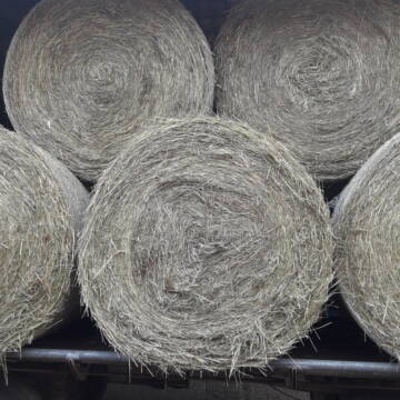
Rundballen Stroh
Elze-Esbeck
Hof Bartels
@Bartels
Stroh
Lieferant entlädt
Rundballen
Regenfrei
3 weitere...
B+
Deprecated: Creation of dynamic property Zend_View_Helper_Ads::$adLink is deprecated in /var/www/stall-frei/htdocs/staging.stall-frei.de/library/Psf/View/Helper/Ads.php on line 108

***Reitstall Birkenhof*** Pferdegerechte Haltung
Köln
Daniele-Fazzi
@Daniele-Fazzi
Herzlich Willkommen
auf dem Reitstall Birkenhof
Jetzt neu ‼️ auf dem Birkenhof:
Private Geländestrecke rund um unser

Leider kein Vorschaubild
Leider kein Vorschaubild
Heu - HD Ballen aus Juni 2025
Wunstorf
Heike-Wichmann-Sasse
@Heike-Wichmann-Sasse
Heu
Empfänger lädt ab
Kleinballen/HD-Ballen
Regenfrei
2 weitere...
B+
Heu Rundballen zu verkaufen
Peine
Hof-Hoppenworth
@Hof-Hoppenworth
Heu
Empfänger lädt ab
Rundballen
Regenfrei
3 weitere...
B+

Persönlichkeitsentwicklung mit Pferden
Bad Salzuflen
Katja Dors
@Pferdezeiten
Begleite andere auf ihrem Entwicklungsweg und entdecke die transformative Kraft der pferdegestützten Persönlichkeitsentwicklung !
neu
R


1 Palette Stramofarm Strohpellets 30Sack á 25KG
Leinefelde- Worbis
stramofarm GmbH
@stramofarm
Einstreu
Lieferant entlädt
Pellets
Regenfrei
2 weitere...
P+


1 Palette Stramofarm Heupellets 30 Sack á 15Kg
Leinefelde
stramofarm GmbH
@stramofarm
Heu
Lieferant entlädt
Pellets
Regenfrei
2 weitere...
P+

Heu in Quaderballen zu verkaufen
Bergen
Bianca Hinrichs-Schröder
@BHS1976
Futter
Empfänger lädt ab
Kleinballen/HD-Ballen
Bio
Regenfrei
2 weitere...
B+
Leider kein Vorschaubild
Leider kein Vorschaubild
HD-Ballen Handballen Heu Heuballen Ernte 2024
Wolfsburg
Bendlin GbR
@Bendlin_GbR
Heu
Kleinballen/HD-Ballen
Regenfrei
Käufer lädt selbst
2 weitere...
B+
Leider kein Vorschaubild
Leider kein Vorschaubild
HD-Ballen Handballen Stroh Strohballen Ernte 2024
Wolfsburg
Bendlin GbR
@Bendlin_GbR
Stroh
Kleinballen/HD-Ballen
Regenfrei
Käufer lädt selbst
2 weitere...
B+
Deprecated: Creation of dynamic property Zend_View::$pageCount is deprecated in /var/www/stall-frei/htdocs/staging.stall-frei.de/library/vendor/shardj/zf1-future/library/Zend/View/Abstract.php on line 308
Deprecated: Creation of dynamic property Zend_View::$itemCountPerPage is deprecated in /var/www/stall-frei/htdocs/staging.stall-frei.de/library/vendor/shardj/zf1-future/library/Zend/View/Abstract.php on line 308
Deprecated: Creation of dynamic property Zend_View::$first is deprecated in /var/www/stall-frei/htdocs/staging.stall-frei.de/library/vendor/shardj/zf1-future/library/Zend/View/Abstract.php on line 308
Deprecated: Creation of dynamic property Zend_View::$current is deprecated in /var/www/stall-frei/htdocs/staging.stall-frei.de/library/vendor/shardj/zf1-future/library/Zend/View/Abstract.php on line 308
Deprecated: Creation of dynamic property Zend_View::$last is deprecated in /var/www/stall-frei/htdocs/staging.stall-frei.de/library/vendor/shardj/zf1-future/library/Zend/View/Abstract.php on line 308
Deprecated: Creation of dynamic property Zend_View::$next is deprecated in /var/www/stall-frei/htdocs/staging.stall-frei.de/library/vendor/shardj/zf1-future/library/Zend/View/Abstract.php on line 308
Deprecated: Creation of dynamic property Zend_View::$pagesInRange is deprecated in /var/www/stall-frei/htdocs/staging.stall-frei.de/library/vendor/shardj/zf1-future/library/Zend/View/Abstract.php on line 308
Deprecated: Creation of dynamic property Zend_View::$firstPageInRange is deprecated in /var/www/stall-frei/htdocs/staging.stall-frei.de/library/vendor/shardj/zf1-future/library/Zend/View/Abstract.php on line 308
Deprecated: Creation of dynamic property Zend_View::$lastPageInRange is deprecated in /var/www/stall-frei/htdocs/staging.stall-frei.de/library/vendor/shardj/zf1-future/library/Zend/View/Abstract.php on line 308
Deprecated: Creation of dynamic property Zend_View::$currentItemCount is deprecated in /var/www/stall-frei/htdocs/staging.stall-frei.de/library/vendor/shardj/zf1-future/library/Zend/View/Abstract.php on line 308
Deprecated: Creation of dynamic property Zend_View::$totalItemCount is deprecated in /var/www/stall-frei/htdocs/staging.stall-frei.de/library/vendor/shardj/zf1-future/library/Zend/View/Abstract.php on line 308
Deprecated: Creation of dynamic property Zend_View::$firstItemNumber is deprecated in /var/www/stall-frei/htdocs/staging.stall-frei.de/library/vendor/shardj/zf1-future/library/Zend/View/Abstract.php on line 308
Deprecated: Creation of dynamic property Zend_View::$lastItemNumber is deprecated in /var/www/stall-frei/htdocs/staging.stall-frei.de/library/vendor/shardj/zf1-future/library/Zend/View/Abstract.php on line 308
Deprecated: Creation of dynamic property Zend_View::$router is deprecated in /var/www/stall-frei/htdocs/staging.stall-frei.de/library/vendor/shardj/zf1-future/library/Zend/View/Abstract.php on line 308
Deprecated: Creation of dynamic property Zend_View::$urlParams is deprecated in /var/www/stall-frei/htdocs/staging.stall-frei.de/library/vendor/shardj/zf1-future/library/Zend/View/Abstract.php on line 308
Deprecated: Creation of dynamic property Zend_View::$showAds is deprecated in /var/www/stall-frei/htdocs/staging.stall-frei.de/library/vendor/shardj/zf1-future/library/Zend/View/Abstract.php on line 308
Deprecated: Creation of dynamic property Zend_View::$objectIds is deprecated in /var/www/stall-frei/htdocs/staging.stall-frei.de/library/vendor/shardj/zf1-future/library/Zend/View/Abstract.php on line 308
Deprecated: Creation of dynamic property Zend_View::$showNavbar is deprecated in /var/www/stall-frei/htdocs/staging.stall-frei.de/library/vendor/shardj/zf1-future/library/Zend/View/Abstract.php on line 308
Deprecated: Creation of dynamic property Zend_View::$showBreadcrumb is deprecated in /var/www/stall-frei/htdocs/staging.stall-frei.de/library/vendor/shardj/zf1-future/library/Zend/View/Abstract.php on line 308
Deprecated: Creation of dynamic property Zend_View::$showFooter is deprecated in /var/www/stall-frei/htdocs/staging.stall-frei.de/library/vendor/shardj/zf1-future/library/Zend/View/Abstract.php on line 308
Deprecated: Creation of dynamic property Zend_View::$showInternalAds is deprecated in /var/www/stall-frei/htdocs/staging.stall-frei.de/library/vendor/shardj/zf1-future/library/Zend/View/Abstract.php on line 308
Deprecated: Creation of dynamic property Zend_View::$blNoContent is deprecated in /var/www/stall-frei/htdocs/staging.stall-frei.de/library/vendor/shardj/zf1-future/library/Zend/View/Abstract.php on line 308
Deprecated: Creation of dynamic property Zend_View::$sMetaDesc is deprecated in /var/www/stall-frei/htdocs/staging.stall-frei.de/library/vendor/shardj/zf1-future/library/Zend/View/Abstract.php on line 308
Deprecated: Creation of dynamic property Zend_View::$useGmaps is deprecated in /var/www/stall-frei/htdocs/staging.stall-frei.de/library/vendor/shardj/zf1-future/library/Zend/View/Abstract.php on line 308
Deprecated: Creation of dynamic property Zend_View::$touches is deprecated in /var/www/stall-frei/htdocs/staging.stall-frei.de/library/vendor/shardj/zf1-future/library/Zend/View/Abstract.php on line 308
Deprecated: Creation of dynamic property Zend_View::$oProject is deprecated in /var/www/stall-frei/htdocs/staging.stall-frei.de/library/vendor/shardj/zf1-future/library/Zend/View/Abstract.php on line 308
Deprecated: Creation of dynamic property Zend_View::$pageHeadline is deprecated in /var/www/stall-frei/htdocs/staging.stall-frei.de/library/vendor/shardj/zf1-future/library/Zend/View/Abstract.php on line 308
Deprecated: Creation of dynamic property Zend_View::$disableLocationField is deprecated in /var/www/stall-frei/htdocs/staging.stall-frei.de/library/vendor/shardj/zf1-future/library/Zend/View/Abstract.php on line 308
Deprecated: Creation of dynamic property Zend_View::$isSearch is deprecated in /var/www/stall-frei/htdocs/staging.stall-frei.de/library/vendor/shardj/zf1-future/library/Zend/View/Abstract.php on line 308
Deprecated: Creation of dynamic property Zend_View::$pageTitle is deprecated in /var/www/stall-frei/htdocs/staging.stall-frei.de/library/vendor/shardj/zf1-future/library/Zend/View/Abstract.php on line 308
Deprecated: Creation of dynamic property Psf_Form_Element_Text::$class is deprecated in /var/www/stall-frei/htdocs/staging.stall-frei.de/library/vendor/shardj/zf1-future/library/Zend/Form/Element.php on line 874
Deprecated: Creation of dynamic property Psf_Form_Element_Text::$size is deprecated in /var/www/stall-frei/htdocs/staging.stall-frei.de/library/vendor/shardj/zf1-future/library/Zend/Form/Element.php on line 874
Deprecated: Creation of dynamic property Psf_Form_Element_Text::$placeholder is deprecated in /var/www/stall-frei/htdocs/staging.stall-frei.de/library/vendor/shardj/zf1-future/library/Zend/Form/Element.php on line 874
Deprecated: Creation of dynamic property Psf_Form_Element_Hidden::$class is deprecated in /var/www/stall-frei/htdocs/staging.stall-frei.de/library/vendor/shardj/zf1-future/library/Zend/Form/Element.php on line 874
Deprecated: Creation of dynamic property Psf_Form_Element_Hidden::$class is deprecated in /var/www/stall-frei/htdocs/staging.stall-frei.de/library/vendor/shardj/zf1-future/library/Zend/Form/Element.php on line 874
Deprecated: Creation of dynamic property Psf_Form_Element_Hidden::$class is deprecated in /var/www/stall-frei/htdocs/staging.stall-frei.de/library/vendor/shardj/zf1-future/library/Zend/Form/Element.php on line 874
Deprecated: Creation of dynamic property Psf_Form_Element_Hidden::$class is deprecated in /var/www/stall-frei/htdocs/staging.stall-frei.de/library/vendor/shardj/zf1-future/library/Zend/Form/Element.php on line 874
Deprecated: Creation of dynamic property Psf_Form_Element_Select::$class is deprecated in /var/www/stall-frei/htdocs/staging.stall-frei.de/library/vendor/shardj/zf1-future/library/Zend/Form/Element.php on line 874
Deprecated: Creation of dynamic property Psf_Form_Element_Select::$class is deprecated in /var/www/stall-frei/htdocs/staging.stall-frei.de/library/vendor/shardj/zf1-future/library/Zend/Form/Element.php on line 874
Deprecated: Creation of dynamic property Psf_Form_Element_Select::$class is deprecated in /var/www/stall-frei/htdocs/staging.stall-frei.de/library/vendor/shardj/zf1-future/library/Zend/Form/Element.php on line 874
Deprecated: Creation of dynamic property Psf_Form_Element_Select::$class is deprecated in /var/www/stall-frei/htdocs/staging.stall-frei.de/library/vendor/shardj/zf1-future/library/Zend/Form/Element.php on line 874
Deprecated: Creation of dynamic property Zend_View::$sort is deprecated in /var/www/stall-frei/htdocs/staging.stall-frei.de/library/vendor/shardj/zf1-future/library/Zend/View/Abstract.php on line 308
Deprecated: Creation of dynamic property Zend_View::$searchLocation is deprecated in /var/www/stall-frei/htdocs/staging.stall-frei.de/library/vendor/shardj/zf1-future/library/Zend/View/Abstract.php on line 308
Deprecated: Creation of dynamic property Zend_View::$locationHint is deprecated in /var/www/stall-frei/htdocs/staging.stall-frei.de/library/vendor/shardj/zf1-future/library/Zend/View/Abstract.php on line 308
Psf_GeoCoder_Abstract::getLocation: Blomberg Get Location CachedOrLive
Psf_GeoCoder_Abstract::getCachedOrLive: Blomberg
Psf_GeoCoder_Abstract::convertLocationResult
{"documentation":"https:\/\/opencagedata.com\/api","licenses":[{"name":"see attribution guide","url":"https:\/\/opencagedata.com\/credits"}],"results":[{"bounds":{"northeast":{"lat":52.0117837,"lng":9.19531},"southwest":{"lat":51.8984522,"lng":8.9576307}},"components":{"ISO_3166-1_alpha-2":"DE","ISO_3166-1_alpha-3":"DEU","ISO_3166-2":["DE-NW"],"_category":"place","_normalized_city":"Blomberg","_type":"city","continent":"Europe","country":"Deutschland","country_code":"de","county":"Kreis Lippe","political_union":"European Union","postcode":"32825","state":"Nordrhein-Westfalen","state_code":"NW","town":"Blomberg"},"confidence":6,"formatted":"32825 Blomberg, Deutschland","geometry":{"lat":51.9434473,"lng":9.0967908}},{"bounds":{"northeast":{"lat":53.5934288,"lng":7.5944895},"southwest":{"lat":53.5512858,"lng":7.5213895}},"components":{"ISO_3166-1_alpha-2":"DE","ISO_3166-1_alpha-3":"DEU","ISO_3166-2":["DE-NI"],"_category":"place","_normalized_city":"Blomberg","_type":"village","continent":"Europe","country":"Deutschland","country_code":"de","county":"Landkreis Wittmund","municipality":"Samtgemeinde Holtriem","political_union":"European Union","state":"Niedersachsen","state_code":"NI","village":"Blomberg"},"confidence":7,"formatted":"Blomberg, Niedersachsen, Deutschland","geometry":{"lat":53.5776116,"lng":7.5597035}},{"bounds":{"northeast":{"lat":52.110127,"lng":8.1073284},"southwest":{"lat":52.110027,"lng":8.1072284}},"components":{"ISO_3166-1_alpha-2":"DE","ISO_3166-1_alpha-3":"DEU","ISO_3166-2":["DE-NI"],"_category":"natural\/water","_normalized_city":"Bad Laer","_type":"peak","city":"Bad Laer","continent":"Europe","country":"Deutschland","country_code":"de","county":"Landkreis Osnabr\u00fcck","peak":"Blomberg","political_union":"European Union","postcode":"49196","state":"Niedersachsen","state_code":"NI"},"confidence":9,"formatted":"Blomberg, 49196 Bad Laer, Deutschland","geometry":{"lat":52.110077,"lng":8.1072784}},{"bounds":{"northeast":{"lat":51.974125,"lng":9.1592998},"southwest":{"lat":51.9232851,"lng":9.0628751}},"components":{"ISO_3166-1_alpha-2":"DE","ISO_3166-1_alpha-3":"DEU","ISO_3166-2":["DE-NW"],"_category":"place","_normalized_city":"Blomberg","_type":"neighbourhood","continent":"Europe","country":"Deutschland","country_code":"de","county":"Kreis Lippe","political_union":"European Union","state":"Nordrhein-Westfalen","state_code":"NW","suburb":"Blomberg","town":"Blomberg"},"confidence":7,"formatted":"Blomberg, Nordrhein-Westfalen, Deutschland","geometry":{"lat":51.9488871,"lng":9.1149637}},{"bounds":{"northeast":{"lat":51.1312561,"lng":7.7393308},"southwest":{"lat":51.0912561,"lng":7.6993308}},"components":{"ISO_3166-1_alpha-2":"DE","ISO_3166-1_alpha-3":"DEU","ISO_3166-2":["DE-NW"],"_category":"place","_normalized_city":"Meinerzhagen","_type":"hamlet","continent":"Europe","country":"Deutschland","country_code":"de","county":"M\u00e4rkischer Kreis","hamlet":"Blomberg","political_union":"European Union","postcode":"58540","state":"Nordrhein-Westfalen","state_code":"NW","town":"Meinerzhagen"},"confidence":7,"formatted":"Blomberg, 58540 Meinerzhagen, Deutschland","geometry":{"lat":51.1112561,"lng":7.7193308}},{"components":{"ISO_3166-1_alpha-2":"FR","ISO_3166-1_alpha-3":"FRA","ISO_3166-2":["FR-IDF","FR-92"],"_category":"road","_normalized_city":"Levallois-Perret","_type":"road","city":"Levallois-Perret","continent":"Europe","country":"France","country_code":"fr","county":"Hauts-de-Seine","local_authority":"M\u00e9tropole du Grand Paris","political_union":"European Union","postcode":"92300","road":"Rue Charles Deutschmann","state":"\u00cele-de-France","state_code":"IDF"},"confidence":2,"formatted":"Rue Charles Deutschmann, 92300 Levallois-Perret, France","geometry":{"lat":48.900049,"lng":2.2842}},{"components":{"ISO_3166-1_alpha-2":"FR","ISO_3166-1_alpha-3":"FRA","ISO_3166-2":["FR-ARA","FR-74"],"_category":"road","_normalized_city":"Dingy-Saint-Clair","_type":"road","city":"Dingy-Saint-Clair","continent":"Europe","country":"France","country_code":"fr","county":"Haute-Savoie","local_authority":"Communaut\u00e9 de communes des Vall\u00e9es de Th\u00f4nes","political_union":"European Union","postcode":"74230","road":"Route de la Blonni\u00e8re","state":"Auvergne-Rh\u00f4ne-Alpes","state_code":"ARA"},"confidence":2,"formatted":"Route de la Blonni\u00e8re, 74230 Dingy-Saint-Clair, France","geometry":{"lat":45.921737,"lng":6.225321}},{"components":{"ISO_3166-1_alpha-2":"FR","ISO_3166-1_alpha-3":"FRA","ISO_3166-2":["FR-PDL","FR-72"],"_category":"road","_normalized_city":"Mansign\u00e9","_type":"road","city":"Mansign\u00e9","continent":"Europe","country":"France","country_code":"fr","county":"Sarthe","local_authority":"Communaut\u00e9 de communes Sud Sarthe","political_union":"European Union","postcode":"72510","road":"Route de la Blonniere","state":"Pays de la Loire","state_code":"PDL"},"confidence":2,"formatted":"Route de la Blonniere, 72510 Mansign\u00e9, France","geometry":{"lat":47.734376,"lng":0.108871}},{"components":{"ISO_3166-1_alpha-2":"FR","ISO_3166-1_alpha-3":"FRA","ISO_3166-2":["FR-ARA","FR-01"],"_category":"road","_normalized_city":"Cerdon","_type":"road","city":"Cerdon","continent":"Europe","country":"France","country_code":"fr","county":"Ain","local_authority":"Communaut\u00e9 de communes Rives de l\u2019Ain - Pays du Cerdon","political_union":"European Union","postcode":"01450","road":"Place Allombert","state":"Auvergne-Rh\u00f4ne-Alpes","state_code":"ARA"},"confidence":2,"formatted":"Place Allombert, 01450 Cerdon, France","geometry":{"lat":46.080499,"lng":5.465641}},{"components":{"ISO_3166-1_alpha-2":"FR","ISO_3166-1_alpha-3":"FRA","ISO_3166-2":["FR-PDL","FR-49"],"_category":"road","_normalized_city":"Saint-Germain-des-Pr\u00e9s","_type":"road","city":"Saint-Germain-des-Pr\u00e9s","continent":"Europe","country":"France","country_code":"fr","county":"Maine-et-Loire","local_authority":"Communaut\u00e9 de communes Loire Layon Aubance","political_union":"European Union","postcode":"49170","road":"Chemin de la Blonni\u00e8re","state":"Pays de la Loire","state_code":"PDL"},"confidence":2,"formatted":"Chemin de la Blonni\u00e8re, 49170 Saint-Germain-des-Pr\u00e9s, France","geometry":{"lat":47.436669,"lng":-0.818846}}],"status":{"code":200,"message":"OK"},"stay_informed":{"blog":"https:\/\/blog.opencagedata.com","mastodon":"https:\/\/en.osm.town\/@opencage"},"thanks":"For using an OpenCage API","timestamp":{"created_http":"Sat, 07 Feb 2026 12:02:49 GMT","created_unix":1770465769},"total_results":10}Array
(
[0] => stdClass Object
(
[bounds] => stdClass Object
(
[northeast] => stdClass Object
(
[lat] => 52.0117837
[lng] => 9.19531
)
[southwest] => stdClass Object
(
[lat] => 51.8984522
[lng] => 8.9576307
)
)
[components] => stdClass Object
(
[ISO_3166-1_alpha-2] => DE
[ISO_3166-1_alpha-3] => DEU
[ISO_3166-2] => Array
(
[0] => DE-NW
)
[_category] => place
[_normalized_city] => Blomberg
[_type] => city
[continent] => Europe
[country] => Deutschland
[country_code] => de
[county] => Kreis Lippe
[political_union] => European Union
[postcode] => 32825
[state] => Nordrhein-Westfalen
[state_code] => NW
[town] => Blomberg
)
[confidence] => 6
[formatted] => 32825 Blomberg, Deutschland
[geometry] => stdClass Object
(
[lat] => 51.9434473
[lng] => 9.0967908
)
)
[1] => stdClass Object
(
[bounds] => stdClass Object
(
[northeast] => stdClass Object
(
[lat] => 53.5934288
[lng] => 7.5944895
)
[southwest] => stdClass Object
(
[lat] => 53.5512858
[lng] => 7.5213895
)
)
[components] => stdClass Object
(
[ISO_3166-1_alpha-2] => DE
[ISO_3166-1_alpha-3] => DEU
[ISO_3166-2] => Array
(
[0] => DE-NI
)
[_category] => place
[_normalized_city] => Blomberg
[_type] => village
[continent] => Europe
[country] => Deutschland
[country_code] => de
[county] => Landkreis Wittmund
[municipality] => Samtgemeinde Holtriem
[political_union] => European Union
[state] => Niedersachsen
[state_code] => NI
[village] => Blomberg
)
[confidence] => 7
[formatted] => Blomberg, Niedersachsen, Deutschland
[geometry] => stdClass Object
(
[lat] => 53.5776116
[lng] => 7.5597035
)
)
[2] => stdClass Object
(
[bounds] => stdClass Object
(
[northeast] => stdClass Object
(
[lat] => 52.110127
[lng] => 8.1073284
)
[southwest] => stdClass Object
(
[lat] => 52.110027
[lng] => 8.1072284
)
)
[components] => stdClass Object
(
[ISO_3166-1_alpha-2] => DE
[ISO_3166-1_alpha-3] => DEU
[ISO_3166-2] => Array
(
[0] => DE-NI
)
[_category] => natural/water
[_normalized_city] => Bad Laer
[_type] => peak
[city] => Bad Laer
[continent] => Europe
[country] => Deutschland
[country_code] => de
[county] => Landkreis Osnabrück
[peak] => Blomberg
[political_union] => European Union
[postcode] => 49196
[state] => Niedersachsen
[state_code] => NI
)
[confidence] => 9
[formatted] => Blomberg, 49196 Bad Laer, Deutschland
[geometry] => stdClass Object
(
[lat] => 52.110077
[lng] => 8.1072784
)
)
[3] => stdClass Object
(
[bounds] => stdClass Object
(
[northeast] => stdClass Object
(
[lat] => 51.974125
[lng] => 9.1592998
)
[southwest] => stdClass Object
(
[lat] => 51.9232851
[lng] => 9.0628751
)
)
[components] => stdClass Object
(
[ISO_3166-1_alpha-2] => DE
[ISO_3166-1_alpha-3] => DEU
[ISO_3166-2] => Array
(
[0] => DE-NW
)
[_category] => place
[_normalized_city] => Blomberg
[_type] => neighbourhood
[continent] => Europe
[country] => Deutschland
[country_code] => de
[county] => Kreis Lippe
[political_union] => European Union
[state] => Nordrhein-Westfalen
[state_code] => NW
[suburb] => Blomberg
[town] => Blomberg
)
[confidence] => 7
[formatted] => Blomberg, Nordrhein-Westfalen, Deutschland
[geometry] => stdClass Object
(
[lat] => 51.9488871
[lng] => 9.1149637
)
)
[4] => stdClass Object
(
[bounds] => stdClass Object
(
[northeast] => stdClass Object
(
[lat] => 51.1312561
[lng] => 7.7393308
)
[southwest] => stdClass Object
(
[lat] => 51.0912561
[lng] => 7.6993308
)
)
[components] => stdClass Object
(
[ISO_3166-1_alpha-2] => DE
[ISO_3166-1_alpha-3] => DEU
[ISO_3166-2] => Array
(
[0] => DE-NW
)
[_category] => place
[_normalized_city] => Meinerzhagen
[_type] => hamlet
[continent] => Europe
[country] => Deutschland
[country_code] => de
[county] => Märkischer Kreis
[hamlet] => Blomberg
[political_union] => European Union
[postcode] => 58540
[state] => Nordrhein-Westfalen
[state_code] => NW
[town] => Meinerzhagen
)
[confidence] => 7
[formatted] => Blomberg, 58540 Meinerzhagen, Deutschland
[geometry] => stdClass Object
(
[lat] => 51.1112561
[lng] => 7.7193308
)
)
[5] => stdClass Object
(
[components] => stdClass Object
(
[ISO_3166-1_alpha-2] => FR
[ISO_3166-1_alpha-3] => FRA
[ISO_3166-2] => Array
(
[0] => FR-IDF
[1] => FR-92
)
[_category] => road
[_normalized_city] => Levallois-Perret
[_type] => road
[city] => Levallois-Perret
[continent] => Europe
[country] => France
[country_code] => fr
[county] => Hauts-de-Seine
[local_authority] => Métropole du Grand Paris
[political_union] => European Union
[postcode] => 92300
[road] => Rue Charles Deutschmann
[state] => Île-de-France
[state_code] => IDF
)
[confidence] => 2
[formatted] => Rue Charles Deutschmann, 92300 Levallois-Perret, France
[geometry] => stdClass Object
(
[lat] => 48.900049
[lng] => 2.2842
)
)
[6] => stdClass Object
(
[components] => stdClass Object
(
[ISO_3166-1_alpha-2] => FR
[ISO_3166-1_alpha-3] => FRA
[ISO_3166-2] => Array
(
[0] => FR-ARA
[1] => FR-74
)
[_category] => road
[_normalized_city] => Dingy-Saint-Clair
[_type] => road
[city] => Dingy-Saint-Clair
[continent] => Europe
[country] => France
[country_code] => fr
[county] => Haute-Savoie
[local_authority] => Communauté de communes des Vallées de Thônes
[political_union] => European Union
[postcode] => 74230
[road] => Route de la Blonnière
[state] => Auvergne-Rhône-Alpes
[state_code] => ARA
)
[confidence] => 2
[formatted] => Route de la Blonnière, 74230 Dingy-Saint-Clair, France
[geometry] => stdClass Object
(
[lat] => 45.921737
[lng] => 6.225321
)
)
[7] => stdClass Object
(
[components] => stdClass Object
(
[ISO_3166-1_alpha-2] => FR
[ISO_3166-1_alpha-3] => FRA
[ISO_3166-2] => Array
(
[0] => FR-PDL
[1] => FR-72
)
[_category] => road
[_normalized_city] => Mansigné
[_type] => road
[city] => Mansigné
[continent] => Europe
[country] => France
[country_code] => fr
[county] => Sarthe
[local_authority] => Communauté de communes Sud Sarthe
[political_union] => European Union
[postcode] => 72510
[road] => Route de la Blonniere
[state] => Pays de la Loire
[state_code] => PDL
)
[confidence] => 2
[formatted] => Route de la Blonniere, 72510 Mansigné, France
[geometry] => stdClass Object
(
[lat] => 47.734376
[lng] => 0.108871
)
)
[8] => stdClass Object
(
[components] => stdClass Object
(
[ISO_3166-1_alpha-2] => FR
[ISO_3166-1_alpha-3] => FRA
[ISO_3166-2] => Array
(
[0] => FR-ARA
[1] => FR-01
)
[_category] => road
[_normalized_city] => Cerdon
[_type] => road
[city] => Cerdon
[continent] => Europe
[country] => France
[country_code] => fr
[county] => Ain
[local_authority] => Communauté de communes Rives de l’Ain - Pays du Cerdon
[political_union] => European Union
[postcode] => 01450
[road] => Place Allombert
[state] => Auvergne-Rhône-Alpes
[state_code] => ARA
)
[confidence] => 2
[formatted] => Place Allombert, 01450 Cerdon, France
[geometry] => stdClass Object
(
[lat] => 46.080499
[lng] => 5.465641
)
)
[9] => stdClass Object
(
[components] => stdClass Object
(
[ISO_3166-1_alpha-2] => FR
[ISO_3166-1_alpha-3] => FRA
[ISO_3166-2] => Array
(
[0] => FR-PDL
[1] => FR-49
)
[_category] => road
[_normalized_city] => Saint-Germain-des-Prés
[_type] => road
[city] => Saint-Germain-des-Prés
[continent] => Europe
[country] => France
[country_code] => fr
[county] => Maine-et-Loire
[local_authority] => Communauté de communes Loire Layon Aubance
[political_union] => European Union
[postcode] => 49170
[road] => Chemin de la Blonnière
[state] => Pays de la Loire
[state_code] => PDL
)
[confidence] => 2
[formatted] => Chemin de la Blonnière, 49170 Saint-Germain-des-Prés, France
[geometry] => stdClass Object
(
[lat] => 47.436669
[lng] => -0.818846
)
)
)
Psf_GeoCoder_OpenCageData::getKeyMap: 0
stdClass Object
(
    [bounds] => stdClass Object
        (
            [northeast] => stdClass Object
                (
                    [lat] => 52.0117837
                    [lng] => 9.19531
                )

            [southwest] => stdClass Object
                (
                    [lat] => 51.8984522
                    [lng] => 8.9576307
                )

        )

    [components] => stdClass Object
        (
            [ISO_3166-1_alpha-2] => DE
            [ISO_3166-1_alpha-3] => DEU
            [ISO_3166-2] => Array
                (
                    [0] => DE-NW
                )

            [_category] => place
            [_normalized_city] => Blomberg
            [_type] => city
            [continent] => Europe
            [country] => Deutschland
            [country_code] => de
            [county] => Kreis Lippe
            [political_union] => European Union
            [postcode] => 32825
            [state] => Nordrhein-Westfalen
            [state_code] => NW
            [town] => Blomberg
        )

    [confidence] => 6
    [formatted] => 32825 Blomberg, Deutschland
    [geometry] => stdClass Object
        (
            [lat] => 51.9434473
            [lng] => 9.0967908
        )

)
Psf_GeoCoder_OpenCageData::getCounty: Lippe
Psf_GeoCoder_OpenCageData::addMissingData REFETCH!
Array
(
    [address] => 32825 Blomberg, Deutschland
    [type] => city
    [street] =>
    [city] => Blomberg
    [county] => Lippe
    [state] => Nordrhein-Westfalen
    [zip] => 32825
    [country] => Deutschland
    [suburb] =>
    [countrycode] => de
    [latitude] => 51.9434473
    [longitude] => 9.0967908
    [accuracy] => 1
    [confidence] => 6
    [bounds] => stdClass Object
        (
            [northeast] => stdClass Object
                (
                    [lat] => 52.0117837
                    [lng] => 9.19531
                )

            [southwest] => stdClass Object
                (
                    [lat] => 51.8984522
                    [lng] => 8.9576307
                )

        )

)
reformat!
Array
(
    [address] => 32825 Blomberg, Deutschland
    [type] => city
    [street] =>
    [city] => Blomberg
    [county] => Lippe
    [state] => Nordrhein-Westfalen
    [zip] => 32825
    [country] => Deutschland
    [suburb] =>
    [countrycode] => de
    [latitude] => 51.9434473
    [longitude] => 9.0967908
    [accuracy] => 1
    [confidence] => 6
    [bounds] => stdClass Object
        (
            [northeast] => stdClass Object
                (
                    [lat] => 52.0117837
                    [lng] => 9.19531
                )

            [southwest] => stdClass Object
                (
                    [lat] => 51.8984522
                    [lng] => 8.9576307
                )

        )

    [place] => 32825 Blomberg, Nordrhein-Westfalen
    [hash] => 51adb6a96918ab1d15e7c602c6512a94
)
Psf_GeoCoder_OpenCageData::getKeyMap: 1
stdClass Object
(
    [bounds] => stdClass Object
        (
            [northeast] => stdClass Object
                (
                    [lat] => 53.5934288
                    [lng] => 7.5944895
                )

            [southwest] => stdClass Object
                (
                    [lat] => 53.5512858
                    [lng] => 7.5213895
                )

        )

    [components] => stdClass Object
        (
            [ISO_3166-1_alpha-2] => DE
            [ISO_3166-1_alpha-3] => DEU
            [ISO_3166-2] => Array
                (
                    [0] => DE-NI
                )

            [_category] => place
            [_normalized_city] => Blomberg
            [_type] => village
            [continent] => Europe
            [country] => Deutschland
            [country_code] => de
            [county] => Landkreis Wittmund
            [municipality] => Samtgemeinde Holtriem
            [political_union] => European Union
            [state] => Niedersachsen
            [state_code] => NI
            [village] => Blomberg
        )

    [confidence] => 7
    [formatted] => Blomberg, Niedersachsen, Deutschland
    [geometry] => stdClass Object
        (
            [lat] => 53.5776116
            [lng] => 7.5597035
        )

)
Psf_GeoCoder_OpenCageData::getCounty: Wittmund
Psf_GeoCoder_OpenCageData::addMissingData REFETCH!
Array
(
    [address] => Blomberg, Niedersachsen, Deutschland
    [type] => village
    [street] =>
    [city] => Blomberg
    [county] => Wittmund
    [state] => Niedersachsen
    [zip] =>
    [country] => Deutschland
    [suburb] =>
    [countrycode] => de
    [latitude] => 53.5776116
    [longitude] => 7.5597035
    [accuracy] => 1
    [confidence] => 7
    [bounds] => stdClass Object
        (
            [northeast] => stdClass Object
                (
                    [lat] => 53.5934288
                    [lng] => 7.5944895
                )

            [southwest] => stdClass Object
                (
                    [lat] => 53.5512858
                    [lng] => 7.5213895
                )

        )

)
reformat!
Array
(
    [address] => Blomberg, Niedersachsen, Deutschland
    [type] => village
    [street] =>
    [city] => Blomberg
    [county] => Wittmund
    [state] => Niedersachsen
    [zip] =>
    [country] => Deutschland
    [suburb] =>
    [countrycode] => de
    [latitude] => 53.5776116
    [longitude] => 7.5597035
    [accuracy] => 1
    [confidence] => 7
    [bounds] => stdClass Object
        (
            [northeast] => stdClass Object
                (
                    [lat] => 53.5934288
                    [lng] => 7.5944895
                )

            [southwest] => stdClass Object
                (
                    [lat] => 53.5512858
                    [lng] => 7.5213895
                )

        )

    [place] => Blomberg, Niedersachsen
    [hash] => 780412f2c2cbb99c8558ef3a3f05cea6
)
Psf_GeoCoder_OpenCageData::getKeyMap: 2
stdClass Object
(
    [bounds] => stdClass Object
        (
            [northeast] => stdClass Object
                (
                    [lat] => 52.110127
                    [lng] => 8.1073284
                )

            [southwest] => stdClass Object
                (
                    [lat] => 52.110027
                    [lng] => 8.1072284
                )

        )

    [components] => stdClass Object
        (
            [ISO_3166-1_alpha-2] => DE
            [ISO_3166-1_alpha-3] => DEU
            [ISO_3166-2] => Array
                (
                    [0] => DE-NI
                )

            [_category] => natural/water
            [_normalized_city] => Bad Laer
            [_type] => peak
            [city] => Bad Laer
            [continent] => Europe
            [country] => Deutschland
            [country_code] => de
            [county] => Landkreis Osnabrück
            [peak] => Blomberg
            [political_union] => European Union
            [postcode] => 49196
            [state] => Niedersachsen
            [state_code] => NI
        )

    [confidence] => 9
    [formatted] => Blomberg, 49196 Bad Laer, Deutschland
    [geometry] => stdClass Object
        (
            [lat] => 52.110077
            [lng] => 8.1072784
        )

)
Psf_GeoCoder_OpenCageData::getCounty: Osnabrück
Psf_GeoCoder_OpenCageData::addMissingData REFETCH!
Array
(
    [address] => Blomberg, 49196 Bad Laer, Deutschland
    [type] => peak
    [street] =>
    [city] => Bad Laer
    [county] => Osnabrück
    [state] => Niedersachsen
    [zip] => 49196
    [country] => Deutschland
    [suburb] =>
    [countrycode] => de
    [latitude] => 52.110077
    [longitude] => 8.1072784
    [accuracy] => 1
    [confidence] => 9
    [bounds] => stdClass Object
        (
            [northeast] => stdClass Object
                (
                    [lat] => 52.110127
                    [lng] => 8.1073284
                )

            [southwest] => stdClass Object
                (
                    [lat] => 52.110027
                    [lng] => 8.1072284
                )

        )

)
reformat!
Array
(
    [address] => Blomberg, 49196 Bad Laer, Deutschland
    [type] => peak
    [street] =>
    [city] => Bad Laer
    [county] => Osnabrück
    [state] => Niedersachsen
    [zip] => 49196
    [country] => Deutschland
    [suburb] =>
    [countrycode] => de
    [latitude] => 52.110077
    [longitude] => 8.1072784
    [accuracy] => 1
    [confidence] => 9
    [bounds] => stdClass Object
        (
            [northeast] => stdClass Object
                (
                    [lat] => 52.110127
                    [lng] => 8.1073284
                )

            [southwest] => stdClass Object
                (
                    [lat] => 52.110027
                    [lng] => 8.1072284
                )

        )

    [place] => 49196 Bad Laer, Niedersachsen
    [hash] => 114bf37bfb8082d3fd96a63f69efa323
)
Psf_GeoCoder_OpenCageData::getKeyMap: 3
stdClass Object
(
    [bounds] => stdClass Object
        (
            [northeast] => stdClass Object
                (
                    [lat] => 51.974125
                    [lng] => 9.1592998
                )

            [southwest] => stdClass Object
                (
                    [lat] => 51.9232851
                    [lng] => 9.0628751
                )

        )

    [components] => stdClass Object
        (
            [ISO_3166-1_alpha-2] => DE
            [ISO_3166-1_alpha-3] => DEU
            [ISO_3166-2] => Array
                (
                    [0] => DE-NW
                )

            [_category] => place
            [_normalized_city] => Blomberg
            [_type] => neighbourhood
            [continent] => Europe
            [country] => Deutschland
            [country_code] => de
            [county] => Kreis Lippe
            [political_union] => European Union
            [state] => Nordrhein-Westfalen
            [state_code] => NW
            [suburb] => Blomberg
            [town] => Blomberg
        )

    [confidence] => 7
    [formatted] => Blomberg, Nordrhein-Westfalen, Deutschland
    [geometry] => stdClass Object
        (
            [lat] => 51.9488871
            [lng] => 9.1149637
        )

)
Psf_GeoCoder_OpenCageData::getCounty: Lippe
Psf_GeoCoder_OpenCageData::addMissingData REFETCH!
Array
(
    [address] => Blomberg, Nordrhein-Westfalen, Deutschland
    [type] => neighbourhood
    [street] =>
    [city] => Blomberg
    [county] => Lippe
    [state] => Nordrhein-Westfalen
    [zip] =>
    [country] => Deutschland
    [suburb] => Blomberg
    [countrycode] => de
    [latitude] => 51.9488871
    [longitude] => 9.1149637
    [accuracy] => 1
    [confidence] => 7
    [bounds] => stdClass Object
        (
            [northeast] => stdClass Object
                (
                    [lat] => 51.974125
                    [lng] => 9.1592998
                )

            [southwest] => stdClass Object
                (
                    [lat] => 51.9232851
                    [lng] => 9.0628751
                )

        )

)
reformat!
Array
(
    [address] => Blomberg, Nordrhein-Westfalen, Deutschland
    [type] => neighbourhood
    [street] =>
    [city] => Blomberg
    [county] => Lippe
    [state] => Nordrhein-Westfalen
    [zip] =>
    [country] => Deutschland
    [suburb] => Blomberg
    [countrycode] => de
    [latitude] => 51.9488871
    [longitude] => 9.1149637
    [accuracy] => 1
    [confidence] => 7
    [bounds] => stdClass Object
        (
            [northeast] => stdClass Object
                (
                    [lat] => 51.974125
                    [lng] => 9.1592998
                )

            [southwest] => stdClass Object
                (
                    [lat] => 51.9232851
                    [lng] => 9.0628751
                )

        )

    [place] => Blomberg, Nordrhein-Westfalen
    [hash] => a651c886df63f176ce9b275b536f776f
)
Psf_GeoCoder_OpenCageData::getKeyMap: 4
stdClass Object
(
    [bounds] => stdClass Object
        (
            [northeast] => stdClass Object
                (
                    [lat] => 51.1312561
                    [lng] => 7.7393308
                )

            [southwest] => stdClass Object
                (
                    [lat] => 51.0912561
                    [lng] => 7.6993308
                )

        )

    [components] => stdClass Object
        (
            [ISO_3166-1_alpha-2] => DE
            [ISO_3166-1_alpha-3] => DEU
            [ISO_3166-2] => Array
                (
                    [0] => DE-NW
                )

            [_category] => place
            [_normalized_city] => Meinerzhagen
            [_type] => hamlet
            [continent] => Europe
            [country] => Deutschland
            [country_code] => de
            [county] => Märkischer Kreis
            [hamlet] => Blomberg
            [political_union] => European Union
            [postcode] => 58540
            [state] => Nordrhein-Westfalen
            [state_code] => NW
            [town] => Meinerzhagen
        )

    [confidence] => 7
    [formatted] => Blomberg, 58540 Meinerzhagen, Deutschland
    [geometry] => stdClass Object
        (
            [lat] => 51.1112561
            [lng] => 7.7193308
        )

)
Psf_GeoCoder_OpenCageData::getCounty: Märkischer Kreis
Psf_GeoCoder_OpenCageData::addMissingData REFETCH!
Array
(
    [address] => Blomberg, 58540 Meinerzhagen, Deutschland
    [type] => hamlet
    [street] => Blomberg
    [city] => Meinerzhagen
    [county] => Märkischer Kreis
    [state] => Nordrhein-Westfalen
    [zip] => 58540
    [country] => Deutschland
    [suburb] =>
    [countrycode] => de
    [latitude] => 51.1112561
    [longitude] => 7.7193308
    [accuracy] => 1
    [confidence] => 7
    [bounds] => stdClass Object
        (
            [northeast] => stdClass Object
                (
                    [lat] => 51.1312561
                    [lng] => 7.7393308
                )

            [southwest] => stdClass Object
                (
                    [lat] => 51.0912561
                    [lng] => 7.6993308
                )

        )

)
reformat!
Array
(
    [address] => Blomberg, 58540 Meinerzhagen, Deutschland
    [type] => hamlet
    [street] => Blomberg
    [city] => Meinerzhagen
    [county] => Märkischer Kreis
    [state] => Nordrhein-Westfalen
    [zip] => 58540
    [country] => Deutschland
    [suburb] =>
    [countrycode] => de
    [latitude] => 51.1112561
    [longitude] => 7.7193308
    [accuracy] => 1
    [confidence] => 7
    [bounds] => stdClass Object
        (
            [northeast] => stdClass Object
                (
                    [lat] => 51.1312561
                    [lng] => 7.7393308
                )

            [southwest] => stdClass Object
                (
                    [lat] => 51.0912561
                    [lng] => 7.6993308
                )

        )

    [place] => Blomberg, 58540 Meinerzhagen, Nordrhein-Westfalen
    [hash] => dbc1876382e7f10f1f70a02061ba7f93
)
Psf_GeoCoder_OpenCageData::getKeyMap: 5
stdClass Object
(
    [components] => stdClass Object
        (
            [ISO_3166-1_alpha-2] => FR
            [ISO_3166-1_alpha-3] => FRA
            [ISO_3166-2] => Array
                (
                    [0] => FR-IDF
                    [1] => FR-92
                )

            [_category] => road
            [_normalized_city] => Levallois-Perret
            [_type] => road
            [city] => Levallois-Perret
            [continent] => Europe
            [country] => France
            [country_code] => fr
            [county] => Hauts-de-Seine
            [local_authority] => Métropole du Grand Paris
            [political_union] => European Union
            [postcode] => 92300
            [road] => Rue Charles Deutschmann
            [state] => Île-de-France
            [state_code] => IDF
        )

    [confidence] => 2
    [formatted] => Rue Charles Deutschmann, 92300 Levallois-Perret, France
    [geometry] => stdClass Object
        (
            [lat] => 48.900049
            [lng] => 2.2842
        )

)
Psf_GeoCoder_OpenCageData::getCounty: Hauts-de-Seine
Psf_GeoCoder_OpenCageData::addMissingData REFETCH!
Array
(
    [address] => Rue Charles Deutschmann, 92300 Levallois-Perret, France
    [type] => road
    [street] => Rue Charles Deutschmann
    [city] => Levallois-Perret
    [county] => Hauts-de-Seine
    [state] => Île-de-France
    [zip] => 92300
    [country] => France
    [suburb] =>
    [countrycode] => fr
    [latitude] => 48.900049
    [longitude] => 2.2842
    [accuracy] => 1
    [confidence] => 2
    [bounds] =>
)
reformat!
Array
(
    [address] => Rue Charles Deutschmann, 92300 Levallois-Perret, France
    [type] => road
    [street] => Rue Charles Deutschmann
    [city] => Levallois-Perret
    [county] => Hauts-de-Seine
    [state] => Île-de-France
    [zip] => 92300
    [country] => France
    [suburb] =>
    [countrycode] => fr
    [latitude] => 48.900049
    [longitude] => 2.2842
    [accuracy] => 1
    [confidence] => 2
    [bounds] =>
    [place] => Rue Charles Deutschmann, 92300 Levallois-Perret, Île-de-France
    [hash] => b7dc44def3990e8a7eaf18e019eca466
)
Psf_GeoCoder_OpenCageData::getKeyMap: 6
stdClass Object
(
    [components] => stdClass Object
        (
            [ISO_3166-1_alpha-2] => FR
            [ISO_3166-1_alpha-3] => FRA
            [ISO_3166-2] => Array
                (
                    [0] => FR-ARA
                    [1] => FR-74
                )

            [_category] => road
            [_normalized_city] => Dingy-Saint-Clair
            [_type] => road
            [city] => Dingy-Saint-Clair
            [continent] => Europe
            [country] => France
            [country_code] => fr
            [county] => Haute-Savoie
            [local_authority] => Communauté de communes des Vallées de Thônes
            [political_union] => European Union
            [postcode] => 74230
            [road] => Route de la Blonnière
            [state] => Auvergne-Rhône-Alpes
            [state_code] => ARA
        )

    [confidence] => 2
    [formatted] => Route de la Blonnière, 74230 Dingy-Saint-Clair, France
    [geometry] => stdClass Object
        (
            [lat] => 45.921737
            [lng] => 6.225321
        )

)
Psf_GeoCoder_OpenCageData::getCounty: Haute-Savoie
Psf_GeoCoder_OpenCageData::addMissingData REFETCH!
Array
(
    [address] => Route de la Blonnière, 74230 Dingy-Saint-Clair, France
    [type] => road
    [street] => Route de la Blonnière
    [city] => Dingy-Saint-Clair
    [county] => Haute-Savoie
    [state] => Auvergne-Rhône-Alpes
    [zip] => 74230
    [country] => France
    [suburb] =>
    [countrycode] => fr
    [latitude] => 45.921737
    [longitude] => 6.225321
    [accuracy] => 1
    [confidence] => 2
    [bounds] =>
)
reformat!
Array
(
    [address] => Route de la Blonnière, 74230 Dingy-Saint-Clair, France
    [type] => road
    [street] => Route de la Blonnière
    [city] => Dingy-Saint-Clair
    [county] => Haute-Savoie
    [state] => Auvergne-Rhône-Alpes
    [zip] => 74230
    [country] => France
    [suburb] =>
    [countrycode] => fr
    [latitude] => 45.921737
    [longitude] => 6.225321
    [accuracy] => 1
    [confidence] => 2
    [bounds] =>
    [place] => Route de la Blonnière, 74230 Dingy-Saint-Clair, Auvergne-Rhône-Alpes
    [hash] => 4d9d277d893e1a63a6e5bb245db0188a
)
Psf_GeoCoder_OpenCageData::getKeyMap: 7
stdClass Object
(
    [components] => stdClass Object
        (
            [ISO_3166-1_alpha-2] => FR
            [ISO_3166-1_alpha-3] => FRA
            [ISO_3166-2] => Array
                (
                    [0] => FR-PDL
                    [1] => FR-72
                )

            [_category] => road
            [_normalized_city] => Mansigné
            [_type] => road
            [city] => Mansigné
            [continent] => Europe
            [country] => France
            [country_code] => fr
            [county] => Sarthe
            [local_authority] => Communauté de communes Sud Sarthe
            [political_union] => European Union
            [postcode] => 72510
            [road] => Route de la Blonniere
            [state] => Pays de la Loire
            [state_code] => PDL
        )

    [confidence] => 2
    [formatted] => Route de la Blonniere, 72510 Mansigné, France
    [geometry] => stdClass Object
        (
            [lat] => 47.734376
            [lng] => 0.108871
        )

)
Psf_GeoCoder_OpenCageData::getCounty: Sarthe
Psf_GeoCoder_OpenCageData::addMissingData REFETCH!
Array
(
    [address] => Route de la Blonniere, 72510 Mansigné, France
    [type] => road
    [street] => Route de la Blonniere
    [city] => Mansigné
    [county] => Sarthe
    [state] => Pays de la Loire
    [zip] => 72510
    [country] => France
    [suburb] =>
    [countrycode] => fr
    [latitude] => 47.734376
    [longitude] => 0.108871
    [accuracy] => 1
    [confidence] => 2
    [bounds] =>
)
reformat!
Array
(
    [address] => Route de la Blonniere, 72510 Mansigné, France
    [type] => road
    [street] => Route de la Blonniere
    [city] => Mansigné
    [county] => Sarthe
    [state] => Pays de la Loire
    [zip] => 72510
    [country] => France
    [suburb] =>
    [countrycode] => fr
    [latitude] => 47.734376
    [longitude] => 0.108871
    [accuracy] => 1
    [confidence] => 2
    [bounds] =>
    [place] => Route de la Blonniere, 72510 Mansigné, Pays de la Loire
    [hash] => 1ea61d5675eb737adab309efea28d7f9
)
Psf_GeoCoder_OpenCageData::getKeyMap: 8
stdClass Object
(
    [components] => stdClass Object
        (
            [ISO_3166-1_alpha-2] => FR
            [ISO_3166-1_alpha-3] => FRA
            [ISO_3166-2] => Array
                (
                    [0] => FR-ARA
                    [1] => FR-01
                )

            [_category] => road
            [_normalized_city] => Cerdon
            [_type] => road
            [city] => Cerdon
            [continent] => Europe
            [country] => France
            [country_code] => fr
            [county] => Ain
            [local_authority] => Communauté de communes Rives de l’Ain - Pays du Cerdon
            [political_union] => European Union
            [postcode] => 01450
            [road] => Place Allombert
            [state] => Auvergne-Rhône-Alpes
            [state_code] => ARA
        )

    [confidence] => 2
    [formatted] => Place Allombert, 01450 Cerdon, France
    [geometry] => stdClass Object
        (
            [lat] => 46.080499
            [lng] => 5.465641
        )

)
Psf_GeoCoder_OpenCageData::getCounty: Ain
Psf_GeoCoder_OpenCageData::addMissingData REFETCH!
Array
(
    [address] => Place Allombert, 01450 Cerdon, France
    [type] => road
    [street] => Place Allombert
    [city] => Cerdon
    [county] => Ain
    [state] => Auvergne-Rhône-Alpes
    [zip] => 01450
    [country] => France
    [suburb] =>
    [countrycode] => fr
    [latitude] => 46.080499
    [longitude] => 5.465641
    [accuracy] => 1
    [confidence] => 2
    [bounds] =>
)
reformat!
Array
(
    [address] => Place Allombert, 01450 Cerdon, France
    [type] => road
    [street] => Place Allombert
    [city] => Cerdon
    [county] => Ain
    [state] => Auvergne-Rhône-Alpes
    [zip] => 01450
    [country] => France
    [suburb] =>
    [countrycode] => fr
    [latitude] => 46.080499
    [longitude] => 5.465641
    [accuracy] => 1
    [confidence] => 2
    [bounds] =>
    [place] => Place Allombert, 01450 Cerdon, Auvergne-Rhône-Alpes
    [hash] => 95b0c4bf4af596b36bc3c374240b991b
)
Psf_GeoCoder_OpenCageData::getKeyMap: 9
stdClass Object
(
    [components] => stdClass Object
        (
            [ISO_3166-1_alpha-2] => FR
            [ISO_3166-1_alpha-3] => FRA
            [ISO_3166-2] => Array
                (
                    [0] => FR-PDL
                    [1] => FR-49
                )

            [_category] => road
            [_normalized_city] => Saint-Germain-des-Prés
            [_type] => road
            [city] => Saint-Germain-des-Prés
            [continent] => Europe
            [country] => France
            [country_code] => fr
            [county] => Maine-et-Loire
            [local_authority] => Communauté de communes Loire Layon Aubance
            [political_union] => European Union
            [postcode] => 49170
            [road] => Chemin de la Blonnière
            [state] => Pays de la Loire
            [state_code] => PDL
        )

    [confidence] => 2
    [formatted] => Chemin de la Blonnière, 49170 Saint-Germain-des-Prés, France
    [geometry] => stdClass Object
        (
            [lat] => 47.436669
            [lng] => -0.818846
        )

)
Psf_GeoCoder_OpenCageData::getCounty: Maine-et-Loire
Psf_GeoCoder_OpenCageData::addMissingData REFETCH!
Array
(
    [address] => Chemin de la Blonnière, 49170 Saint-Germain-des-Prés, France
    [type] => road
    [street] => Chemin de la Blonnière
    [city] => Saint-Germain-des-Prés
    [county] => Maine-et-Loire
    [state] => Pays de la Loire
    [zip] => 49170
    [country] => France
    [suburb] =>
    [countrycode] => fr
    [latitude] => 47.436669
    [longitude] => -0.818846
    [accuracy] => 1
    [confidence] => 2
    [bounds] =>
)
reformat!
Array
(
    [address] => Chemin de la Blonnière, 49170 Saint-Germain-des-Prés, France
    [type] => road
    [street] => Chemin de la Blonnière
    [city] => Saint-Germain-des-Prés
    [county] => Maine-et-Loire
    [state] => Pays de la Loire
    [zip] => 49170
    [country] => France
    [suburb] =>
    [countrycode] => fr
    [latitude] => 47.436669
    [longitude] => -0.818846
    [accuracy] => 1
    [confidence] => 2
    [bounds] =>
    [place] => Chemin de la Blonnière, 49170 Saint-Germain-des-Prés, Pays de la Loire
    [hash] => 4550b2915fe79f981f3d6a045b1705e1
)
Deprecated: Creation of dynamic property Zend_View::$locationHintStyle is deprecated in /var/www/stall-frei/htdocs/staging.stall-frei.de/library/vendor/shardj/zf1-future/library/Zend/View/Abstract.php on line 308
Deprecated: Creation of dynamic property Zend_View::$adGeoLocation is deprecated in /var/www/stall-frei/htdocs/staging.stall-frei.de/library/vendor/shardj/zf1-future/library/Zend/View/Abstract.php on line 308
Deprecated: Creation of dynamic property Zend_View::$recordCount is deprecated in /var/www/stall-frei/htdocs/staging.stall-frei.de/library/vendor/shardj/zf1-future/library/Zend/View/Abstract.php on line 308
Deprecated: explode(): Passing null to parameter #2 ($string) of type string is deprecated in /var/www/stall-frei/htdocs/staging.stall-frei.de/application/models/SearchAgent.php on line 100
Deprecated: explode(): Passing null to parameter #2 ($string) of type string is deprecated in /var/www/stall-frei/htdocs/staging.stall-frei.de/application/models/SearchAgent.php on line 100
Deprecated: explode(): Passing null to parameter #2 ($string) of type string is deprecated in /var/www/stall-frei/htdocs/staging.stall-frei.de/application/models/SearchAgent.php on line 100
Deprecated: explode(): Passing null to parameter #2 ($string) of type string is deprecated in /var/www/stall-frei/htdocs/staging.stall-frei.de/application/models/SearchAgent.php on line 100
Deprecated: explode(): Passing null to parameter #2 ($string) of type string is deprecated in /var/www/stall-frei/htdocs/staging.stall-frei.de/application/models/SearchAgent.php on line 100
Deprecated: explode(): Passing null to parameter #2 ($string) of type string is deprecated in /var/www/stall-frei/htdocs/staging.stall-frei.de/application/models/SearchAgent.php on line 100
Deprecated: trim(): Passing null to parameter #1 ($string) of type string is deprecated in /var/www/stall-frei/htdocs/staging.stall-frei.de/application/models/Account/Search.php on line 82
Warning: Cannot modify header information - headers already sent by (output started at /var/www/stall-frei/htdocs/staging.stall-frei.de/library/vendor/shardj/zf1-future/library/Zend/View/Abstract.php:308) in /var/www/stall-frei/htdocs/staging.stall-frei.de/application/models/Account/Search.php on line 71
Deprecated: Creation of dynamic property Zend_View::$paginationParams is deprecated in /var/www/stall-frei/htdocs/staging.stall-frei.de/library/vendor/shardj/zf1-future/library/Zend/View/Abstract.php on line 308
Deprecated: Creation of dynamic property Zend_View::$objectPaginator is deprecated in /var/www/stall-frei/htdocs/staging.stall-frei.de/library/vendor/shardj/zf1-future/library/Zend/View/Abstract.php on line 308
Deprecated: Creation of dynamic property Zend_View::$featuredObjects is deprecated in /var/www/stall-frei/htdocs/staging.stall-frei.de/library/vendor/shardj/zf1-future/library/Zend/View/Abstract.php on line 308
Deprecated: Creation of dynamic property Zend_View::$hints is deprecated in /var/www/stall-frei/htdocs/staging.stall-frei.de/library/vendor/shardj/zf1-future/library/Zend/View/Abstract.php on line 308
Deprecated: Creation of dynamic property Zend_View::$attributeHints is deprecated in /var/www/stall-frei/htdocs/staging.stall-frei.de/library/vendor/shardj/zf1-future/library/Zend/View/Abstract.php on line 308
Deprecated: Creation of dynamic property Zend_View::$oSearchForm is deprecated in /var/www/stall-frei/htdocs/staging.stall-frei.de/library/vendor/shardj/zf1-future/library/Zend/View/Abstract.php on line 308