Deprecated: Creation of dynamic property Zend_View::$sMode is deprecated in /var/www/stall-frei/htdocs/staging.stall-frei.de/library/vendor/shardj/zf1-future/library/Zend/View/Abstract.php on line 308
Heu, Stroh oder Futter in Bad Wurzelsdorf
Gesucht wird in "Schwarzer Berg, Bad Wurzelsdorf, SO ORP Tanvald, Tschechien"
95 Einträge
Deprecated: Creation of dynamic property Zend_View::$listObjects is deprecated in /var/www/stall-frei/htdocs/staging.stall-frei.de/library/vendor/shardj/zf1-future/library/Zend/View/Abstract.php on line 308
Deprecated: Creation of dynamic property Zend_View::$listMode is deprecated in /var/www/stall-frei/htdocs/staging.stall-frei.de/library/vendor/shardj/zf1-future/library/Zend/View/Abstract.php on line 308
Deprecated: Creation of dynamic property Zend_View::$renderedObjects is deprecated in /var/www/stall-frei/htdocs/staging.stall-frei.de/library/vendor/shardj/zf1-future/library/Zend/View/Abstract.php on line 308
Deprecated: Creation of dynamic property Zend_View::$index is deprecated in /var/www/stall-frei/htdocs/staging.stall-frei.de/library/vendor/shardj/zf1-future/library/Zend/View/Abstract.php on line 308
Deprecated: Creation of dynamic property Zend_View::$displayMode is deprecated in /var/www/stall-frei/htdocs/staging.stall-frei.de/library/vendor/shardj/zf1-future/library/Zend/View/Abstract.php on line 308
Deprecated: Creation of dynamic property Zend_View::$remarketingIds is deprecated in /var/www/stall-frei/htdocs/staging.stall-frei.de/library/vendor/shardj/zf1-future/library/Zend/View/Abstract.php on line 308
Deprecated: Creation of dynamic property Zend_View::$listItem is deprecated in /var/www/stall-frei/htdocs/staging.stall-frei.de/library/vendor/shardj/zf1-future/library/Zend/View/Abstract.php on line 308
Deprecated: Creation of dynamic property Zend_View::$object is deprecated in /var/www/stall-frei/htdocs/staging.stall-frei.de/library/vendor/shardj/zf1-future/library/Zend/View/Abstract.php on line 308
Deprecated: Creation of dynamic property Zend_View::$attributes is deprecated in /var/www/stall-frei/htdocs/staging.stall-frei.de/library/vendor/shardj/zf1-future/library/Zend/View/Abstract.php on line 308

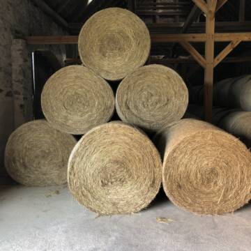
Haferstroh 1.50m Ernte 25 Ausgezeichnete Qualität
Cavertitz
LWB Streubel
@Landwirtschaftsbetr.-Streubel
Stroh
Lieferant entlädt
Rundballen
Regenfrei
3 weitere...
B+
Deprecated: Creation of dynamic property Zend_View_Helper_Ads::$adLink is deprecated in /var/www/stall-frei/htdocs/staging.stall-frei.de/library/Psf/View/Helper/Ads.php on line 108

Futtersack HeuToy, Fressbremse in pink
Mechtersen
STALL-FREIde Marketing
@STALL-FREI-Marketing
Stundenlange Beschäftigung die
Koliken vorbeugt, geringe Staubinhalation mit
steuerbarer Futterentnahme
Pferdeheu 1.Schnitt Juli 2025/Rundballen 1.50m
Cavertitz
LWB Streubel
@Landwirtschaftsbetr.-Streubel
Heu
Lieferant entlädt
Rundballen
Bio
Regenfrei
3 weitere...
B+


Futtermittel & Einstreu mit Lieferung!
Schwaara
MK-Agrarprodukte
@MK-Agrarprodukte
Heu
Empfänger lädt ab
Großballen
Regenfrei
2 weitere...
P+
Leider kein Vorschaubild
Leider kein Vorschaubild
BIO-Heu, 1. Schnitt 2025, Quaderballen (60x40x30)
Tirpersdorf
Forstbaumschule
@Forstbaumschule
Heu
Kleinballen/HD-Ballen
Bio
Regenfrei
Wird verladen
1 weitere...
B+
Leider kein Vorschaubild
Leider kein Vorschaubild
Bio-Heu, 1. Schnitt aus 2024 (BIOLAND) zu verkauf.
Tirpersdorf
Forstbaumschule
@Forstbaumschule
Heu
Empfänger lädt ab
Großballen
Bio
Regenfrei
2 weitere...
B+

Heu aus neuer Ernte
Mechtersen
STALL-FREIde Marketing
@STALL-FREI-Marketing
Heulage und Pferdeheu aus der neuen Ernte findest du in unserem Futtermarkt
Leider kein Vorschaubild
Leider kein Vorschaubild
BIO-Heu, 1. Schnitt 2024, Quaderballen (60x40x30)
Tirpersdorf
Forstbaumschule
@Forstbaumschule
Heu
Kleinballen/HD-Ballen
Bio
Regenfrei
Käufer lädt selbst
1 weitere...
aktuell
B+

Heu und Stroh /Rundballen/Quaderballen
Sandersdorf
jule13
@Jule2024
Stroh
Lieferant entlädt
Rundballen
Regenfrei
3 weitere...
B+

Luzerneheu 1.Schnitt
Teutschenthal
Nancy
@Haltergemeinschaft-TT
Heu
Empfänger lädt ab
Rundballen
Regenfrei
2 weitere...
B+
Leider kein Vorschaubild
Leider kein Vorschaubild
Heu zu verkaufen
Kremmen OT Staffelde
Rhinland Reitpark GmbH
@Rhinland-Reitpark
Heu
Empfänger lädt ab
Rundballen
Regenfrei
3 weitere...
B+

Heupellets und Strohpellets Bio
Bogen
Marion Christ
@Marion-Christ
Einstreu
Pellets
Bio
Abholung
Lieferung
B+
Deprecated: Creation of dynamic property Zend_View::$pageCount is deprecated in /var/www/stall-frei/htdocs/staging.stall-frei.de/library/vendor/shardj/zf1-future/library/Zend/View/Abstract.php on line 308
Deprecated: Creation of dynamic property Zend_View::$itemCountPerPage is deprecated in /var/www/stall-frei/htdocs/staging.stall-frei.de/library/vendor/shardj/zf1-future/library/Zend/View/Abstract.php on line 308
Deprecated: Creation of dynamic property Zend_View::$first is deprecated in /var/www/stall-frei/htdocs/staging.stall-frei.de/library/vendor/shardj/zf1-future/library/Zend/View/Abstract.php on line 308
Deprecated: Creation of dynamic property Zend_View::$current is deprecated in /var/www/stall-frei/htdocs/staging.stall-frei.de/library/vendor/shardj/zf1-future/library/Zend/View/Abstract.php on line 308
Deprecated: Creation of dynamic property Zend_View::$last is deprecated in /var/www/stall-frei/htdocs/staging.stall-frei.de/library/vendor/shardj/zf1-future/library/Zend/View/Abstract.php on line 308
Deprecated: Creation of dynamic property Zend_View::$next is deprecated in /var/www/stall-frei/htdocs/staging.stall-frei.de/library/vendor/shardj/zf1-future/library/Zend/View/Abstract.php on line 308
Deprecated: Creation of dynamic property Zend_View::$pagesInRange is deprecated in /var/www/stall-frei/htdocs/staging.stall-frei.de/library/vendor/shardj/zf1-future/library/Zend/View/Abstract.php on line 308
Deprecated: Creation of dynamic property Zend_View::$firstPageInRange is deprecated in /var/www/stall-frei/htdocs/staging.stall-frei.de/library/vendor/shardj/zf1-future/library/Zend/View/Abstract.php on line 308
Deprecated: Creation of dynamic property Zend_View::$lastPageInRange is deprecated in /var/www/stall-frei/htdocs/staging.stall-frei.de/library/vendor/shardj/zf1-future/library/Zend/View/Abstract.php on line 308
Deprecated: Creation of dynamic property Zend_View::$currentItemCount is deprecated in /var/www/stall-frei/htdocs/staging.stall-frei.de/library/vendor/shardj/zf1-future/library/Zend/View/Abstract.php on line 308
Deprecated: Creation of dynamic property Zend_View::$totalItemCount is deprecated in /var/www/stall-frei/htdocs/staging.stall-frei.de/library/vendor/shardj/zf1-future/library/Zend/View/Abstract.php on line 308
Deprecated: Creation of dynamic property Zend_View::$firstItemNumber is deprecated in /var/www/stall-frei/htdocs/staging.stall-frei.de/library/vendor/shardj/zf1-future/library/Zend/View/Abstract.php on line 308
Deprecated: Creation of dynamic property Zend_View::$lastItemNumber is deprecated in /var/www/stall-frei/htdocs/staging.stall-frei.de/library/vendor/shardj/zf1-future/library/Zend/View/Abstract.php on line 308
Deprecated: Creation of dynamic property Zend_View::$router is deprecated in /var/www/stall-frei/htdocs/staging.stall-frei.de/library/vendor/shardj/zf1-future/library/Zend/View/Abstract.php on line 308
Deprecated: Creation of dynamic property Zend_View::$urlParams is deprecated in /var/www/stall-frei/htdocs/staging.stall-frei.de/library/vendor/shardj/zf1-future/library/Zend/View/Abstract.php on line 308
Deprecated: Creation of dynamic property Zend_View::$showAds is deprecated in /var/www/stall-frei/htdocs/staging.stall-frei.de/library/vendor/shardj/zf1-future/library/Zend/View/Abstract.php on line 308
Deprecated: Creation of dynamic property Zend_View::$objectIds is deprecated in /var/www/stall-frei/htdocs/staging.stall-frei.de/library/vendor/shardj/zf1-future/library/Zend/View/Abstract.php on line 308
Deprecated: Creation of dynamic property Zend_View::$showNavbar is deprecated in /var/www/stall-frei/htdocs/staging.stall-frei.de/library/vendor/shardj/zf1-future/library/Zend/View/Abstract.php on line 308
Deprecated: Creation of dynamic property Zend_View::$showBreadcrumb is deprecated in /var/www/stall-frei/htdocs/staging.stall-frei.de/library/vendor/shardj/zf1-future/library/Zend/View/Abstract.php on line 308
Deprecated: Creation of dynamic property Zend_View::$showFooter is deprecated in /var/www/stall-frei/htdocs/staging.stall-frei.de/library/vendor/shardj/zf1-future/library/Zend/View/Abstract.php on line 308
Deprecated: Creation of dynamic property Zend_View::$showInternalAds is deprecated in /var/www/stall-frei/htdocs/staging.stall-frei.de/library/vendor/shardj/zf1-future/library/Zend/View/Abstract.php on line 308
Deprecated: Creation of dynamic property Zend_View::$blNoContent is deprecated in /var/www/stall-frei/htdocs/staging.stall-frei.de/library/vendor/shardj/zf1-future/library/Zend/View/Abstract.php on line 308
Deprecated: Creation of dynamic property Zend_View::$sMetaDesc is deprecated in /var/www/stall-frei/htdocs/staging.stall-frei.de/library/vendor/shardj/zf1-future/library/Zend/View/Abstract.php on line 308
Deprecated: Creation of dynamic property Zend_View::$useGmaps is deprecated in /var/www/stall-frei/htdocs/staging.stall-frei.de/library/vendor/shardj/zf1-future/library/Zend/View/Abstract.php on line 308
Deprecated: Creation of dynamic property Zend_View::$touches is deprecated in /var/www/stall-frei/htdocs/staging.stall-frei.de/library/vendor/shardj/zf1-future/library/Zend/View/Abstract.php on line 308
Deprecated: Creation of dynamic property Zend_View::$oProject is deprecated in /var/www/stall-frei/htdocs/staging.stall-frei.de/library/vendor/shardj/zf1-future/library/Zend/View/Abstract.php on line 308
Deprecated: Creation of dynamic property Zend_View::$pageHeadline is deprecated in /var/www/stall-frei/htdocs/staging.stall-frei.de/library/vendor/shardj/zf1-future/library/Zend/View/Abstract.php on line 308
Deprecated: Creation of dynamic property Zend_View::$disableLocationField is deprecated in /var/www/stall-frei/htdocs/staging.stall-frei.de/library/vendor/shardj/zf1-future/library/Zend/View/Abstract.php on line 308
Deprecated: Creation of dynamic property Zend_View::$isSearch is deprecated in /var/www/stall-frei/htdocs/staging.stall-frei.de/library/vendor/shardj/zf1-future/library/Zend/View/Abstract.php on line 308
Deprecated: Creation of dynamic property Zend_View::$pageTitle is deprecated in /var/www/stall-frei/htdocs/staging.stall-frei.de/library/vendor/shardj/zf1-future/library/Zend/View/Abstract.php on line 308
Deprecated: Creation of dynamic property Psf_Form_Element_Text::$class is deprecated in /var/www/stall-frei/htdocs/staging.stall-frei.de/library/vendor/shardj/zf1-future/library/Zend/Form/Element.php on line 874
Deprecated: Creation of dynamic property Psf_Form_Element_Text::$size is deprecated in /var/www/stall-frei/htdocs/staging.stall-frei.de/library/vendor/shardj/zf1-future/library/Zend/Form/Element.php on line 874
Deprecated: Creation of dynamic property Psf_Form_Element_Text::$placeholder is deprecated in /var/www/stall-frei/htdocs/staging.stall-frei.de/library/vendor/shardj/zf1-future/library/Zend/Form/Element.php on line 874
Deprecated: Creation of dynamic property Psf_Form_Element_Hidden::$class is deprecated in /var/www/stall-frei/htdocs/staging.stall-frei.de/library/vendor/shardj/zf1-future/library/Zend/Form/Element.php on line 874
Deprecated: Creation of dynamic property Psf_Form_Element_Hidden::$class is deprecated in /var/www/stall-frei/htdocs/staging.stall-frei.de/library/vendor/shardj/zf1-future/library/Zend/Form/Element.php on line 874
Deprecated: Creation of dynamic property Psf_Form_Element_Hidden::$class is deprecated in /var/www/stall-frei/htdocs/staging.stall-frei.de/library/vendor/shardj/zf1-future/library/Zend/Form/Element.php on line 874
Deprecated: Creation of dynamic property Psf_Form_Element_Hidden::$class is deprecated in /var/www/stall-frei/htdocs/staging.stall-frei.de/library/vendor/shardj/zf1-future/library/Zend/Form/Element.php on line 874
Deprecated: Creation of dynamic property Psf_Form_Element_Select::$class is deprecated in /var/www/stall-frei/htdocs/staging.stall-frei.de/library/vendor/shardj/zf1-future/library/Zend/Form/Element.php on line 874
Deprecated: Creation of dynamic property Psf_Form_Element_Select::$class is deprecated in /var/www/stall-frei/htdocs/staging.stall-frei.de/library/vendor/shardj/zf1-future/library/Zend/Form/Element.php on line 874
Deprecated: Creation of dynamic property Psf_Form_Element_Select::$class is deprecated in /var/www/stall-frei/htdocs/staging.stall-frei.de/library/vendor/shardj/zf1-future/library/Zend/Form/Element.php on line 874
Deprecated: Creation of dynamic property Psf_Form_Element_Select::$class is deprecated in /var/www/stall-frei/htdocs/staging.stall-frei.de/library/vendor/shardj/zf1-future/library/Zend/Form/Element.php on line 874
Deprecated: Creation of dynamic property Zend_View::$sort is deprecated in /var/www/stall-frei/htdocs/staging.stall-frei.de/library/vendor/shardj/zf1-future/library/Zend/View/Abstract.php on line 308
Deprecated: Creation of dynamic property Zend_View::$searchLocation is deprecated in /var/www/stall-frei/htdocs/staging.stall-frei.de/library/vendor/shardj/zf1-future/library/Zend/View/Abstract.php on line 308
Deprecated: Creation of dynamic property Zend_View::$locationHint is deprecated in /var/www/stall-frei/htdocs/staging.stall-frei.de/library/vendor/shardj/zf1-future/library/Zend/View/Abstract.php on line 308
Psf_GeoCoder_Abstract::getLocation: Schwarzer Berg Get Location CachedOrLive
Psf_GeoCoder_Abstract::getCachedOrLive: Schwarzer Berg
Psf_GeoCoder_OpenCageData::makeApiRequest: response:
Array
(
[documentation] => https://opencagedata.com/api
[licenses] => Array
(
[0] => Array
(
[name] => see attribution guide
[url] => https://opencagedata.com/credits
)
)
[results] => Array
(
[0] => Array
(
[bounds] => Array
(
[northeast] => Array
(
[lat] => 50.8316074
[lng] => 15.2988371
)
[southwest] => Array
(
[lat] => 50.8315074
[lng] => 15.2987371
)
)
[components] => Array
(
[ISO_3166-1_alpha-2] => CZ
[ISO_3166-1_alpha-3] => CZE
[ISO_3166-2] => Array
(
[0] => CZ-51
[1] => CZ-512
)
[_category] => natural/water
[_normalized_city] => Bad Wurzelsdorf
[_type] => peak
[continent] => Europe
[country] => Tschechien
[country_code] => cz
[county] => SO ORP Tanvald
[municipality] => SO POÚ Tanvald
[peak] => Schwarzer Berg
[political_union] => European Union
[region] => Nordosten
[state] => Reichenberger Region
[state_district] => Bezirk Gablonz
[village] => Bad Wurzelsdorf
)
[confidence] => 9
[formatted] => Schwarzer Berg, Bad Wurzelsdorf, SO ORP Tanvald, Tschechien
[geometry] => Array
(
[lat] => 50.8315574
[lng] => 15.2987871
)
)
[1] => Array
(
[bounds] => Array
(
[northeast] => Array
(
[lat] => 52.4847785
[lng] => 12.5295907
)
[southwest] => Array
(
[lat] => 52.4846785
[lng] => 12.5294907
)
)
[components] => Array
(
[ISO_3166-1_alpha-2] => DE
[ISO_3166-1_alpha-3] => DEU
[ISO_3166-2] => Array
(
[0] => DE-BB
)
[_category] => natural/water
[_normalized_city] => Beetzsee
[_type] => peak
[continent] => Europe
[country] => Deutschland
[country_code] => de
[county] => Potsdam-Mittelmark
[municipality] => Beetzsee
[peak] => Schwarzer Berg
[political_union] => European Union
[state] => Brandenburg
[state_code] => BB
)
[confidence] => 9
[formatted] => Schwarzer Berg, Beetzsee, Brandenburg, Deutschland
[geometry] => Array
(
[lat] => 52.4847285
[lng] => 12.5295407
)
)
[2] => Array
(
[bounds] => Array
(
[northeast] => Array
(
[lat] => 51.0942008
[lng] => 14.8976261
)
[southwest] => Array
(
[lat] => 51.0941008
[lng] => 14.8975261
)
)
[components] => Array
(
[ISO_3166-1_alpha-2] => DE
[ISO_3166-1_alpha-3] => DEU
[ISO_3166-2] => Array
(
[0] => DE-SN
)
[_category] => natural/water
[_normalized_city] => Markersdorf
[_type] => peak
[continent] => Europe
[country] => Deutschland
[country_code] => de
[county] => Görlitz
[peak] => Schwarzer Berg
[political_union] => European Union
[state] => Sachsen
[state_code] => SN
[village] => Markersdorf
)
[confidence] => 9
[formatted] => Schwarzer Berg, Markersdorf, Sachsen, Deutschland
[geometry] => Array
(
[lat] => 51.0941508
[lng] => 14.8975761
)
)
[3] => Array
(
[bounds] => Array
(
[northeast] => Array
(
[lat] => 52.9643644
[lng] => 10.064308
)
[southwest] => Array
(
[lat] => 52.9642644
[lng] => 10.064208
)
)
[components] => Array
(
[ISO_3166-1_alpha-2] => DE
[ISO_3166-1_alpha-3] => DEU
[ISO_3166-2] => Array
(
[0] => DE-NI
)
[_category] => natural/water
[_normalized_city] => Munster
[_type] => peak
[continent] => Europe
[country] => Deutschland
[country_code] => de
[county] => Heidekreis
[peak] => Schwarzer Berg
[political_union] => European Union
[postcode] => 29633
[state] => Niedersachsen
[state_code] => NI
[town] => Munster
)
[confidence] => 9
[formatted] => Schwarzer Berg, 29633 Munster, Deutschland
[geometry] => Array
(
[lat] => 52.9643144
[lng] => 10.064258
)
)
[4] => Array
(
[bounds] => Array
(
[northeast] => Array
(
[lat] => 49.2645361
[lng] => 8.938297
)
[southwest] => Array
(
[lat] => 49.2644361
[lng] => 8.938197
)
)
[components] => Array
(
[ISO_3166-1_alpha-2] => DE
[ISO_3166-1_alpha-3] => DEU
[ISO_3166-2] => Array
(
[0] => DE-BW
)
[_category] => natural/water
[_normalized_city] => Sinsheim
[_type] => peak
[continent] => Europe
[country] => Deutschland
[country_code] => de
[county] => Rhein-Neckar-Kreis
[municipality] => VVG der Stadt Sinsheim
[peak] => Schwarzer Berg
[political_union] => European Union
[postcode] => 74915
[state] => Baden-Württemberg
[state_code] => BW
[town] => Sinsheim
)
[confidence] => 9
[formatted] => Schwarzer Berg, 74915 Sinsheim, Deutschland
[geometry] => Array
(
[lat] => 49.2644861
[lng] => 8.938247
)
)
[5] => Array
(
[bounds] => Array
(
[northeast] => Array
(
[lat] => 52.9704302
[lng] => 7.7410888
)
[southwest] => Array
(
[lat] => 52.9703302
[lng] => 7.7409888
)
)
[components] => Array
(
[ISO_3166-1_alpha-2] => DE
[ISO_3166-1_alpha-3] => DEU
[ISO_3166-2] => Array
(
[0] => DE-NI
)
[_category] => natural/water
[_normalized_city] => Friesoythe
[_type] => peak
[continent] => Europe
[country] => Deutschland
[country_code] => de
[county] => Landkreis Cloppenburg
[peak] => Schwarzer Berg
[political_union] => European Union
[state] => Niedersachsen
[state_code] => NI
[town] => Friesoythe
)
[confidence] => 9
[formatted] => Schwarzer Berg, Friesoythe, Niedersachsen, Deutschland
[geometry] => Array
(
[lat] => 52.9703802
[lng] => 7.7410388
)
)
[6] => Array
(
[bounds] => Array
(
[northeast] => Array
(
[lat] => 51.6970524
[lng] => 14.2708244
)
[southwest] => Array
(
[lat] => 51.6969524
[lng] => 14.2707244
)
)
[components] => Array
(
[ISO_3166-1_alpha-2] => DE
[ISO_3166-1_alpha-3] => DEU
[ISO_3166-2] => Array
(
[0] => DE-BB
)
[_category] => natural/water
[_normalized_city] => Drebkau
[_type] => peak
[continent] => Europe
[country] => Deutschland
[country_code] => de
[county] => Spree-Neiße
[peak] => Schwarzer Berg
[political_union] => European Union
[state] => Brandenburg
[state_code] => BB
[town] => Drebkau
)
[confidence] => 9
[formatted] => Schwarzer Berg, Drebkau, Brandenburg, Deutschland
[geometry] => Array
(
[lat] => 51.6970024
[lng] => 14.2707744
)
)
[7] => Array
(
[bounds] => Array
(
[northeast] => Array
(
[lat] => 47.674089
[lng] => 10.4622505
)
[southwest] => Array
(
[lat] => 47.673989
[lng] => 10.4621505
)
)
[components] => Array
(
[ISO_3166-1_alpha-2] => DE
[ISO_3166-1_alpha-3] => DEU
[ISO_3166-2] => Array
(
[0] => DE-BY
)
[_category] => natural/water
[_normalized_city] => Oy-Mittelberg
[_type] => peak
[city] => Oy-Mittelberg
[continent] => Europe
[country] => Deutschland
[country_code] => de
[county] => Landkreis Oberallgäu
[peak] => Schwarzer Berg
[political_union] => European Union
[postcode] => 87466
[state] => Bayern
[state_code] => BY
)
[confidence] => 9
[formatted] => Schwarzer Berg, 87466 Oy-Mittelberg, Deutschland
[geometry] => Array
(
[lat] => 47.674039
[lng] => 10.4622005
)
)
[8] => Array
(
[bounds] => Array
(
[northeast] => Array
(
[lat] => 50.9217961
[lng] => 10.3522519
)
[southwest] => Array
(
[lat] => 50.9216961
[lng] => 10.3521519
)
)
[components] => Array
(
[ISO_3166-1_alpha-2] => DE
[ISO_3166-1_alpha-3] => DEU
[ISO_3166-2] => Array
(
[0] => DE-TH
)
[_category] => natural/water
[_normalized_city] => Wutha-Farnroda
[_type] => peak
[continent] => Europe
[country] => Deutschland
[country_code] => de
[county] => Wartburgkreis
[peak] => Schwarzer Berg
[political_union] => European Union
[postcode] => 99842
[state] => Thüringen
[state_code] => TH
[town] => Wutha-Farnroda
)
[confidence] => 9
[formatted] => Schwarzer Berg, 99842 Wutha-Farnroda, Deutschland
[geometry] => Array
(
[lat] => 50.9217461
[lng] => 10.3522019
)
)
[9] => Array
(
[bounds] => Array
(
[northeast] => Array
(
[lat] => 52.498444
[lng] => 11.3345087
)
[southwest] => Array
(
[lat] => 52.498344
[lng] => 11.3344087
)
)
[components] => Array
(
[ISO_3166-1_alpha-2] => DE
[ISO_3166-1_alpha-3] => DEU
[ISO_3166-2] => Array
(
[0] => DE-ST
)
[_category] => natural/water
[_normalized_city] => Gardelegen
[_type] => peak
[continent] => Europe
[country] => Deutschland
[country_code] => de
[county] => Altmarkkreis Salzwedel
[peak] => Schwarzer Berg
[political_union] => European Union
[state] => Sachsen-Anhalt
[state_code] => ST
[town] => Gardelegen
)
[confidence] => 9
[formatted] => Schwarzer Berg, Gardelegen, Sachsen-Anhalt, Deutschland
[geometry] => Array
(
[lat] => 52.498394
[lng] => 11.3344587
)
)
)
[status] => Array
(
[code] => 200
[message] => OK
)
[stay_informed] => Array
(
[blog] => https://blog.opencagedata.com
[mastodon] => https://en.osm.town/@opencage
)
[thanks] => For using an OpenCage API
[timestamp] => Array
(
[created_http] => Mon, 09 Feb 2026 09:58:15 GMT
[created_unix] => 1770631095
)
[total_results] => 10
)
Psf_GeoCoder_Abstract::convertLocationResult
{"documentation":"https:\/\/opencagedata.com\/api","licenses":[{"name":"see attribution guide","url":"https:\/\/opencagedata.com\/credits"}],"results":[{"bounds":{"northeast":{"lat":50.8316074,"lng":15.2988371},"southwest":{"lat":50.8315074,"lng":15.2987371}},"components":{"ISO_3166-1_alpha-2":"CZ","ISO_3166-1_alpha-3":"CZE","ISO_3166-2":["CZ-51","CZ-512"],"_category":"natural\/water","_normalized_city":"Bad Wurzelsdorf","_type":"peak","continent":"Europe","country":"Tschechien","country_code":"cz","county":"SO ORP Tanvald","municipality":"SO PO\u00da Tanvald","peak":"Schwarzer Berg","political_union":"European Union","region":"Nordosten","state":"Reichenberger Region","state_district":"Bezirk Gablonz","village":"Bad Wurzelsdorf"},"confidence":9,"formatted":"Schwarzer Berg, Bad Wurzelsdorf, SO ORP Tanvald, Tschechien","geometry":{"lat":50.8315574,"lng":15.2987871}},{"bounds":{"northeast":{"lat":52.4847785,"lng":12.5295907},"southwest":{"lat":52.4846785,"lng":12.5294907}},"components":{"ISO_3166-1_alpha-2":"DE","ISO_3166-1_alpha-3":"DEU","ISO_3166-2":["DE-BB"],"_category":"natural\/water","_normalized_city":"Beetzsee","_type":"peak","continent":"Europe","country":"Deutschland","country_code":"de","county":"Potsdam-Mittelmark","municipality":"Beetzsee","peak":"Schwarzer Berg","political_union":"European Union","state":"Brandenburg","state_code":"BB"},"confidence":9,"formatted":"Schwarzer Berg, Beetzsee, Brandenburg, Deutschland","geometry":{"lat":52.4847285,"lng":12.5295407}},{"bounds":{"northeast":{"lat":51.0942008,"lng":14.8976261},"southwest":{"lat":51.0941008,"lng":14.8975261}},"components":{"ISO_3166-1_alpha-2":"DE","ISO_3166-1_alpha-3":"DEU","ISO_3166-2":["DE-SN"],"_category":"natural\/water","_normalized_city":"Markersdorf","_type":"peak","continent":"Europe","country":"Deutschland","country_code":"de","county":"G\u00f6rlitz","peak":"Schwarzer Berg","political_union":"European Union","state":"Sachsen","state_code":"SN","village":"Markersdorf"},"confidence":9,"formatted":"Schwarzer Berg, Markersdorf, Sachsen, Deutschland","geometry":{"lat":51.0941508,"lng":14.8975761}},{"bounds":{"northeast":{"lat":52.9643644,"lng":10.064308},"southwest":{"lat":52.9642644,"lng":10.064208}},"components":{"ISO_3166-1_alpha-2":"DE","ISO_3166-1_alpha-3":"DEU","ISO_3166-2":["DE-NI"],"_category":"natural\/water","_normalized_city":"Munster","_type":"peak","continent":"Europe","country":"Deutschland","country_code":"de","county":"Heidekreis","peak":"Schwarzer Berg","political_union":"European Union","postcode":"29633","state":"Niedersachsen","state_code":"NI","town":"Munster"},"confidence":9,"formatted":"Schwarzer Berg, 29633 Munster, Deutschland","geometry":{"lat":52.9643144,"lng":10.064258}},{"bounds":{"northeast":{"lat":49.2645361,"lng":8.938297},"southwest":{"lat":49.2644361,"lng":8.938197}},"components":{"ISO_3166-1_alpha-2":"DE","ISO_3166-1_alpha-3":"DEU","ISO_3166-2":["DE-BW"],"_category":"natural\/water","_normalized_city":"Sinsheim","_type":"peak","continent":"Europe","country":"Deutschland","country_code":"de","county":"Rhein-Neckar-Kreis","municipality":"VVG der Stadt Sinsheim","peak":"Schwarzer Berg","political_union":"European Union","postcode":"74915","state":"Baden-W\u00fcrttemberg","state_code":"BW","town":"Sinsheim"},"confidence":9,"formatted":"Schwarzer Berg, 74915 Sinsheim, Deutschland","geometry":{"lat":49.2644861,"lng":8.938247}},{"bounds":{"northeast":{"lat":52.9704302,"lng":7.7410888},"southwest":{"lat":52.9703302,"lng":7.7409888}},"components":{"ISO_3166-1_alpha-2":"DE","ISO_3166-1_alpha-3":"DEU","ISO_3166-2":["DE-NI"],"_category":"natural\/water","_normalized_city":"Friesoythe","_type":"peak","continent":"Europe","country":"Deutschland","country_code":"de","county":"Landkreis Cloppenburg","peak":"Schwarzer Berg","political_union":"European Union","state":"Niedersachsen","state_code":"NI","town":"Friesoythe"},"confidence":9,"formatted":"Schwarzer Berg, Friesoythe, Niedersachsen, Deutschland","geometry":{"lat":52.9703802,"lng":7.7410388}},{"bounds":{"northeast":{"lat":51.6970524,"lng":14.2708244},"southwest":{"lat":51.6969524,"lng":14.2707244}},"components":{"ISO_3166-1_alpha-2":"DE","ISO_3166-1_alpha-3":"DEU","ISO_3166-2":["DE-BB"],"_category":"natural\/water","_normalized_city":"Drebkau","_type":"peak","continent":"Europe","country":"Deutschland","country_code":"de","county":"Spree-Nei\u00dfe","peak":"Schwarzer Berg","political_union":"European Union","state":"Brandenburg","state_code":"BB","town":"Drebkau"},"confidence":9,"formatted":"Schwarzer Berg, Drebkau, Brandenburg, Deutschland","geometry":{"lat":51.6970024,"lng":14.2707744}},{"bounds":{"northeast":{"lat":47.674089,"lng":10.4622505},"southwest":{"lat":47.673989,"lng":10.4621505}},"components":{"ISO_3166-1_alpha-2":"DE","ISO_3166-1_alpha-3":"DEU","ISO_3166-2":["DE-BY"],"_category":"natural\/water","_normalized_city":"Oy-Mittelberg","_type":"peak","city":"Oy-Mittelberg","continent":"Europe","country":"Deutschland","country_code":"de","county":"Landkreis Oberallg\u00e4u","peak":"Schwarzer Berg","political_union":"European Union","postcode":"87466","state":"Bayern","state_code":"BY"},"confidence":9,"formatted":"Schwarzer Berg, 87466 Oy-Mittelberg, Deutschland","geometry":{"lat":47.674039,"lng":10.4622005}},{"bounds":{"northeast":{"lat":50.9217961,"lng":10.3522519},"southwest":{"lat":50.9216961,"lng":10.3521519}},"components":{"ISO_3166-1_alpha-2":"DE","ISO_3166-1_alpha-3":"DEU","ISO_3166-2":["DE-TH"],"_category":"natural\/water","_normalized_city":"Wutha-Farnroda","_type":"peak","continent":"Europe","country":"Deutschland","country_code":"de","county":"Wartburgkreis","peak":"Schwarzer Berg","political_union":"European Union","postcode":"99842","state":"Th\u00fcringen","state_code":"TH","town":"Wutha-Farnroda"},"confidence":9,"formatted":"Schwarzer Berg, 99842 Wutha-Farnroda, Deutschland","geometry":{"lat":50.9217461,"lng":10.3522019}},{"bounds":{"northeast":{"lat":52.498444,"lng":11.3345087},"southwest":{"lat":52.498344,"lng":11.3344087}},"components":{"ISO_3166-1_alpha-2":"DE","ISO_3166-1_alpha-3":"DEU","ISO_3166-2":["DE-ST"],"_category":"natural\/water","_normalized_city":"Gardelegen","_type":"peak","continent":"Europe","country":"Deutschland","country_code":"de","county":"Altmarkkreis Salzwedel","peak":"Schwarzer Berg","political_union":"European Union","state":"Sachsen-Anhalt","state_code":"ST","town":"Gardelegen"},"confidence":9,"formatted":"Schwarzer Berg, Gardelegen, Sachsen-Anhalt, Deutschland","geometry":{"lat":52.498394,"lng":11.3344587}}],"status":{"code":200,"message":"OK"},"stay_informed":{"blog":"https:\/\/blog.opencagedata.com","mastodon":"https:\/\/en.osm.town\/@opencage"},"thanks":"For using an OpenCage API","timestamp":{"created_http":"Mon, 09 Feb 2026 09:58:15 GMT","created_unix":1770631095},"total_results":10}Array
(
[0] => stdClass Object
(
[bounds] => stdClass Object
(
[northeast] => stdClass Object
(
[lat] => 50.8316074
[lng] => 15.2988371
)
[southwest] => stdClass Object
(
[lat] => 50.8315074
[lng] => 15.2987371
)
)
[components] => stdClass Object
(
[ISO_3166-1_alpha-2] => CZ
[ISO_3166-1_alpha-3] => CZE
[ISO_3166-2] => Array
(
[0] => CZ-51
[1] => CZ-512
)
[_category] => natural/water
[_normalized_city] => Bad Wurzelsdorf
[_type] => peak
[continent] => Europe
[country] => Tschechien
[country_code] => cz
[county] => SO ORP Tanvald
[municipality] => SO POÚ Tanvald
[peak] => Schwarzer Berg
[political_union] => European Union
[region] => Nordosten
[state] => Reichenberger Region
[state_district] => Bezirk Gablonz
[village] => Bad Wurzelsdorf
)
[confidence] => 9
[formatted] => Schwarzer Berg, Bad Wurzelsdorf, SO ORP Tanvald, Tschechien
[geometry] => stdClass Object
(
[lat] => 50.8315574
[lng] => 15.2987871
)
)
[1] => stdClass Object
(
[bounds] => stdClass Object
(
[northeast] => stdClass Object
(
[lat] => 52.4847785
[lng] => 12.5295907
)
[southwest] => stdClass Object
(
[lat] => 52.4846785
[lng] => 12.5294907
)
)
[components] => stdClass Object
(
[ISO_3166-1_alpha-2] => DE
[ISO_3166-1_alpha-3] => DEU
[ISO_3166-2] => Array
(
[0] => DE-BB
)
[_category] => natural/water
[_normalized_city] => Beetzsee
[_type] => peak
[continent] => Europe
[country] => Deutschland
[country_code] => de
[county] => Potsdam-Mittelmark
[municipality] => Beetzsee
[peak] => Schwarzer Berg
[political_union] => European Union
[state] => Brandenburg
[state_code] => BB
)
[confidence] => 9
[formatted] => Schwarzer Berg, Beetzsee, Brandenburg, Deutschland
[geometry] => stdClass Object
(
[lat] => 52.4847285
[lng] => 12.5295407
)
)
[2] => stdClass Object
(
[bounds] => stdClass Object
(
[northeast] => stdClass Object
(
[lat] => 51.0942008
[lng] => 14.8976261
)
[southwest] => stdClass Object
(
[lat] => 51.0941008
[lng] => 14.8975261
)
)
[components] => stdClass Object
(
[ISO_3166-1_alpha-2] => DE
[ISO_3166-1_alpha-3] => DEU
[ISO_3166-2] => Array
(
[0] => DE-SN
)
[_category] => natural/water
[_normalized_city] => Markersdorf
[_type] => peak
[continent] => Europe
[country] => Deutschland
[country_code] => de
[county] => Görlitz
[peak] => Schwarzer Berg
[political_union] => European Union
[state] => Sachsen
[state_code] => SN
[village] => Markersdorf
)
[confidence] => 9
[formatted] => Schwarzer Berg, Markersdorf, Sachsen, Deutschland
[geometry] => stdClass Object
(
[lat] => 51.0941508
[lng] => 14.8975761
)
)
[3] => stdClass Object
(
[bounds] => stdClass Object
(
[northeast] => stdClass Object
(
[lat] => 52.9643644
[lng] => 10.064308
)
[southwest] => stdClass Object
(
[lat] => 52.9642644
[lng] => 10.064208
)
)
[components] => stdClass Object
(
[ISO_3166-1_alpha-2] => DE
[ISO_3166-1_alpha-3] => DEU
[ISO_3166-2] => Array
(
[0] => DE-NI
)
[_category] => natural/water
[_normalized_city] => Munster
[_type] => peak
[continent] => Europe
[country] => Deutschland
[country_code] => de
[county] => Heidekreis
[peak] => Schwarzer Berg
[political_union] => European Union
[postcode] => 29633
[state] => Niedersachsen
[state_code] => NI
[town] => Munster
)
[confidence] => 9
[formatted] => Schwarzer Berg, 29633 Munster, Deutschland
[geometry] => stdClass Object
(
[lat] => 52.9643144
[lng] => 10.064258
)
)
[4] => stdClass Object
(
[bounds] => stdClass Object
(
[northeast] => stdClass Object
(
[lat] => 49.2645361
[lng] => 8.938297
)
[southwest] => stdClass Object
(
[lat] => 49.2644361
[lng] => 8.938197
)
)
[components] => stdClass Object
(
[ISO_3166-1_alpha-2] => DE
[ISO_3166-1_alpha-3] => DEU
[ISO_3166-2] => Array
(
[0] => DE-BW
)
[_category] => natural/water
[_normalized_city] => Sinsheim
[_type] => peak
[continent] => Europe
[country] => Deutschland
[country_code] => de
[county] => Rhein-Neckar-Kreis
[municipality] => VVG der Stadt Sinsheim
[peak] => Schwarzer Berg
[political_union] => European Union
[postcode] => 74915
[state] => Baden-Württemberg
[state_code] => BW
[town] => Sinsheim
)
[confidence] => 9
[formatted] => Schwarzer Berg, 74915 Sinsheim, Deutschland
[geometry] => stdClass Object
(
[lat] => 49.2644861
[lng] => 8.938247
)
)
[5] => stdClass Object
(
[bounds] => stdClass Object
(
[northeast] => stdClass Object
(
[lat] => 52.9704302
[lng] => 7.7410888
)
[southwest] => stdClass Object
(
[lat] => 52.9703302
[lng] => 7.7409888
)
)
[components] => stdClass Object
(
[ISO_3166-1_alpha-2] => DE
[ISO_3166-1_alpha-3] => DEU
[ISO_3166-2] => Array
(
[0] => DE-NI
)
[_category] => natural/water
[_normalized_city] => Friesoythe
[_type] => peak
[continent] => Europe
[country] => Deutschland
[country_code] => de
[county] => Landkreis Cloppenburg
[peak] => Schwarzer Berg
[political_union] => European Union
[state] => Niedersachsen
[state_code] => NI
[town] => Friesoythe
)
[confidence] => 9
[formatted] => Schwarzer Berg, Friesoythe, Niedersachsen, Deutschland
[geometry] => stdClass Object
(
[lat] => 52.9703802
[lng] => 7.7410388
)
)
[6] => stdClass Object
(
[bounds] => stdClass Object
(
[northeast] => stdClass Object
(
[lat] => 51.6970524
[lng] => 14.2708244
)
[southwest] => stdClass Object
(
[lat] => 51.6969524
[lng] => 14.2707244
)
)
[components] => stdClass Object
(
[ISO_3166-1_alpha-2] => DE
[ISO_3166-1_alpha-3] => DEU
[ISO_3166-2] => Array
(
[0] => DE-BB
)
[_category] => natural/water
[_normalized_city] => Drebkau
[_type] => peak
[continent] => Europe
[country] => Deutschland
[country_code] => de
[county] => Spree-Neiße
[peak] => Schwarzer Berg
[political_union] => European Union
[state] => Brandenburg
[state_code] => BB
[town] => Drebkau
)
[confidence] => 9
[formatted] => Schwarzer Berg, Drebkau, Brandenburg, Deutschland
[geometry] => stdClass Object
(
[lat] => 51.6970024
[lng] => 14.2707744
)
)
[7] => stdClass Object
(
[bounds] => stdClass Object
(
[northeast] => stdClass Object
(
[lat] => 47.674089
[lng] => 10.4622505
)
[southwest] => stdClass Object
(
[lat] => 47.673989
[lng] => 10.4621505
)
)
[components] => stdClass Object
(
[ISO_3166-1_alpha-2] => DE
[ISO_3166-1_alpha-3] => DEU
[ISO_3166-2] => Array
(
[0] => DE-BY
)
[_category] => natural/water
[_normalized_city] => Oy-Mittelberg
[_type] => peak
[city] => Oy-Mittelberg
[continent] => Europe
[country] => Deutschland
[country_code] => de
[county] => Landkreis Oberallgäu
[peak] => Schwarzer Berg
[political_union] => European Union
[postcode] => 87466
[state] => Bayern
[state_code] => BY
)
[confidence] => 9
[formatted] => Schwarzer Berg, 87466 Oy-Mittelberg, Deutschland
[geometry] => stdClass Object
(
[lat] => 47.674039
[lng] => 10.4622005
)
)
[8] => stdClass Object
(
[bounds] => stdClass Object
(
[northeast] => stdClass Object
(
[lat] => 50.9217961
[lng] => 10.3522519
)
[southwest] => stdClass Object
(
[lat] => 50.9216961
[lng] => 10.3521519
)
)
[components] => stdClass Object
(
[ISO_3166-1_alpha-2] => DE
[ISO_3166-1_alpha-3] => DEU
[ISO_3166-2] => Array
(
[0] => DE-TH
)
[_category] => natural/water
[_normalized_city] => Wutha-Farnroda
[_type] => peak
[continent] => Europe
[country] => Deutschland
[country_code] => de
[county] => Wartburgkreis
[peak] => Schwarzer Berg
[political_union] => European Union
[postcode] => 99842
[state] => Thüringen
[state_code] => TH
[town] => Wutha-Farnroda
)
[confidence] => 9
[formatted] => Schwarzer Berg, 99842 Wutha-Farnroda, Deutschland
[geometry] => stdClass Object
(
[lat] => 50.9217461
[lng] => 10.3522019
)
)
[9] => stdClass Object
(
[bounds] => stdClass Object
(
[northeast] => stdClass Object
(
[lat] => 52.498444
[lng] => 11.3345087
)
[southwest] => stdClass Object
(
[lat] => 52.498344
[lng] => 11.3344087
)
)
[components] => stdClass Object
(
[ISO_3166-1_alpha-2] => DE
[ISO_3166-1_alpha-3] => DEU
[ISO_3166-2] => Array
(
[0] => DE-ST
)
[_category] => natural/water
[_normalized_city] => Gardelegen
[_type] => peak
[continent] => Europe
[country] => Deutschland
[country_code] => de
[county] => Altmarkkreis Salzwedel
[peak] => Schwarzer Berg
[political_union] => European Union
[state] => Sachsen-Anhalt
[state_code] => ST
[town] => Gardelegen
)
[confidence] => 9
[formatted] => Schwarzer Berg, Gardelegen, Sachsen-Anhalt, Deutschland
[geometry] => stdClass Object
(
[lat] => 52.498394
[lng] => 11.3344587
)
)
)
Psf_GeoCoder_OpenCageData::getKeyMap: 0
stdClass Object
(
    [bounds] => stdClass Object
        (
            [northeast] => stdClass Object
                (
                    [lat] => 50.8316074
                    [lng] => 15.2988371
                )

            [southwest] => stdClass Object
                (
                    [lat] => 50.8315074
                    [lng] => 15.2987371
                )

        )

    [components] => stdClass Object
        (
            [ISO_3166-1_alpha-2] => CZ
            [ISO_3166-1_alpha-3] => CZE
            [ISO_3166-2] => Array
                (
                    [0] => CZ-51
                    [1] => CZ-512
                )

            [_category] => natural/water
            [_normalized_city] => Bad Wurzelsdorf
            [_type] => peak
            [continent] => Europe
            [country] => Tschechien
            [country_code] => cz
            [county] => SO ORP Tanvald
            [municipality] => SO POÚ Tanvald
            [peak] => Schwarzer Berg
            [political_union] => European Union
            [region] => Nordosten
            [state] => Reichenberger Region
            [state_district] => Bezirk Gablonz
            [village] => Bad Wurzelsdorf
        )

    [confidence] => 9
    [formatted] => Schwarzer Berg, Bad Wurzelsdorf, SO ORP Tanvald, Tschechien
    [geometry] => stdClass Object
        (
            [lat] => 50.8315574
            [lng] => 15.2987871
        )

)
Psf_GeoCoder_OpenCageData::getCounty: SO ORP Tanvald
Psf_GeoCoder_OpenCageData::addMissingData REFETCH!
Array
(
    [address] => Schwarzer Berg, Bad Wurzelsdorf, SO ORP Tanvald, Tschechien
    [type] => peak
    [street] =>
    [city] => Bad Wurzelsdorf
    [county] => SO ORP Tanvald
    [state] => Reichenberger Region
    [zip] =>
    [country] => Tschechien
    [suburb] =>
    [countrycode] => cz
    [latitude] => 50.8315574
    [longitude] => 15.2987871
    [accuracy] => 1
    [confidence] => 9
    [bounds] => stdClass Object
        (
            [northeast] => stdClass Object
                (
                    [lat] => 50.8316074
                    [lng] => 15.2988371
                )

            [southwest] => stdClass Object
                (
                    [lat] => 50.8315074
                    [lng] => 15.2987371
                )

        )

)
reformat!
Array
(
    [address] => Schwarzer Berg, Bad Wurzelsdorf, SO ORP Tanvald, Tschechien
    [type] => peak
    [street] =>
    [city] => Bad Wurzelsdorf
    [county] => SO ORP Tanvald
    [state] => Reichenberger Region
    [zip] =>
    [country] => Tschechien
    [suburb] =>
    [countrycode] => cz
    [latitude] => 50.8315574
    [longitude] => 15.2987871
    [accuracy] => 1
    [confidence] => 9
    [bounds] => stdClass Object
        (
            [northeast] => stdClass Object
                (
                    [lat] => 50.8316074
                    [lng] => 15.2988371
                )

            [southwest] => stdClass Object
                (
                    [lat] => 50.8315074
                    [lng] => 15.2987371
                )

        )

    [place] => Bad Wurzelsdorf, Reichenberger Region
    [hash] => 551b1260d57b96cfde14e6453ed7a661
)
Psf_GeoCoder_OpenCageData::getKeyMap: 1
stdClass Object
(
    [bounds] => stdClass Object
        (
            [northeast] => stdClass Object
                (
                    [lat] => 52.4847785
                    [lng] => 12.5295907
                )

            [southwest] => stdClass Object
                (
                    [lat] => 52.4846785
                    [lng] => 12.5294907
                )

        )

    [components] => stdClass Object
        (
            [ISO_3166-1_alpha-2] => DE
            [ISO_3166-1_alpha-3] => DEU
            [ISO_3166-2] => Array
                (
                    [0] => DE-BB
                )

            [_category] => natural/water
            [_normalized_city] => Beetzsee
            [_type] => peak
            [continent] => Europe
            [country] => Deutschland
            [country_code] => de
            [county] => Potsdam-Mittelmark
            [municipality] => Beetzsee
            [peak] => Schwarzer Berg
            [political_union] => European Union
            [state] => Brandenburg
            [state_code] => BB
        )

    [confidence] => 9
    [formatted] => Schwarzer Berg, Beetzsee, Brandenburg, Deutschland
    [geometry] => stdClass Object
        (
            [lat] => 52.4847285
            [lng] => 12.5295407
        )

)
Psf_GeoCoder_OpenCageData::getCounty: Potsdam-Mittelmark
Psf_GeoCoder_OpenCageData::addMissingData REFETCH!
Array
(
    [address] => Schwarzer Berg, Beetzsee, Brandenburg, Deutschland
    [type] => peak
    [street] =>
    [city] =>
    [county] => Potsdam-Mittelmark
    [state] => Brandenburg
    [zip] =>
    [country] => Deutschland
    [suburb] =>
    [countrycode] => de
    [latitude] => 52.4847285
    [longitude] => 12.5295407
    [accuracy] => 1
    [confidence] => 9
    [bounds] => stdClass Object
        (
            [northeast] => stdClass Object
                (
                    [lat] => 52.4847785
                    [lng] => 12.5295907
                )

            [southwest] => stdClass Object
                (
                    [lat] => 52.4846785
                    [lng] => 12.5294907
                )

        )

)
reformat!
Array
(
    [address] => Schwarzer Berg, Beetzsee, Brandenburg, Deutschland
    [type] => peak
    [street] =>
    [city] =>
    [county] => Potsdam-Mittelmark
    [state] => Brandenburg
    [zip] =>
    [country] => Deutschland
    [suburb] =>
    [countrycode] => de
    [latitude] => 52.4847285
    [longitude] => 12.5295407
    [accuracy] => 1
    [confidence] => 9
    [bounds] => stdClass Object
        (
            [northeast] => stdClass Object
                (
                    [lat] => 52.4847785
                    [lng] => 12.5295907
                )

            [southwest] => stdClass Object
                (
                    [lat] => 52.4846785
                    [lng] => 12.5294907
                )

        )

    [place] => , Brandenburg
    [hash] => b6ea5c7d00a7bd9cfe24eaec64ca789c
)
Psf_GeoCoder_OpenCageData::getKeyMap: 2
stdClass Object
(
    [bounds] => stdClass Object
        (
            [northeast] => stdClass Object
                (
                    [lat] => 51.0942008
                    [lng] => 14.8976261
                )

            [southwest] => stdClass Object
                (
                    [lat] => 51.0941008
                    [lng] => 14.8975261
                )

        )

    [components] => stdClass Object
        (
            [ISO_3166-1_alpha-2] => DE
            [ISO_3166-1_alpha-3] => DEU
            [ISO_3166-2] => Array
                (
                    [0] => DE-SN
                )

            [_category] => natural/water
            [_normalized_city] => Markersdorf
            [_type] => peak
            [continent] => Europe
            [country] => Deutschland
            [country_code] => de
            [county] => Görlitz
            [peak] => Schwarzer Berg
            [political_union] => European Union
            [state] => Sachsen
            [state_code] => SN
            [village] => Markersdorf
        )

    [confidence] => 9
    [formatted] => Schwarzer Berg, Markersdorf, Sachsen, Deutschland
    [geometry] => stdClass Object
        (
            [lat] => 51.0941508
            [lng] => 14.8975761
        )

)
Psf_GeoCoder_OpenCageData::getCounty: Görlitz
Psf_GeoCoder_OpenCageData::addMissingData REFETCH!
Array
(
    [address] => Schwarzer Berg, Markersdorf, Sachsen, Deutschland
    [type] => peak
    [street] =>
    [city] => Markersdorf
    [county] => Görlitz
    [state] => Sachsen
    [zip] =>
    [country] => Deutschland
    [suburb] =>
    [countrycode] => de
    [latitude] => 51.0941508
    [longitude] => 14.8975761
    [accuracy] => 1
    [confidence] => 9
    [bounds] => stdClass Object
        (
            [northeast] => stdClass Object
                (
                    [lat] => 51.0942008
                    [lng] => 14.8976261
                )

            [southwest] => stdClass Object
                (
                    [lat] => 51.0941008
                    [lng] => 14.8975261
                )

        )

)
reformat!
Array
(
    [address] => Schwarzer Berg, Markersdorf, Sachsen, Deutschland
    [type] => peak
    [street] =>
    [city] => Markersdorf
    [county] => Görlitz
    [state] => Sachsen
    [zip] =>
    [country] => Deutschland
    [suburb] =>
    [countrycode] => de
    [latitude] => 51.0941508
    [longitude] => 14.8975761
    [accuracy] => 1
    [confidence] => 9
    [bounds] => stdClass Object
        (
            [northeast] => stdClass Object
                (
                    [lat] => 51.0942008
                    [lng] => 14.8976261
                )

            [southwest] => stdClass Object
                (
                    [lat] => 51.0941008
                    [lng] => 14.8975261
                )

        )

    [place] => Markersdorf, Sachsen
    [hash] => 9e8f45f943c8a7ad17b4cea7aea892cc
)
Psf_GeoCoder_OpenCageData::getKeyMap: 3
stdClass Object
(
    [bounds] => stdClass Object
        (
            [northeast] => stdClass Object
                (
                    [lat] => 52.9643644
                    [lng] => 10.064308
                )

            [southwest] => stdClass Object
                (
                    [lat] => 52.9642644
                    [lng] => 10.064208
                )

        )

    [components] => stdClass Object
        (
            [ISO_3166-1_alpha-2] => DE
            [ISO_3166-1_alpha-3] => DEU
            [ISO_3166-2] => Array
                (
                    [0] => DE-NI
                )

            [_category] => natural/water
            [_normalized_city] => Munster
            [_type] => peak
            [continent] => Europe
            [country] => Deutschland
            [country_code] => de
            [county] => Heidekreis
            [peak] => Schwarzer Berg
            [political_union] => European Union
            [postcode] => 29633
            [state] => Niedersachsen
            [state_code] => NI
            [town] => Munster
        )

    [confidence] => 9
    [formatted] => Schwarzer Berg, 29633 Munster, Deutschland
    [geometry] => stdClass Object
        (
            [lat] => 52.9643144
            [lng] => 10.064258
        )

)
Psf_GeoCoder_OpenCageData::getCounty: Heidekreis
Psf_GeoCoder_OpenCageData::addMissingData REFETCH!
Array
(
    [address] => Schwarzer Berg, 29633 Munster, Deutschland
    [type] => peak
    [street] =>
    [city] => Munster
    [county] => Heidekreis
    [state] => Niedersachsen
    [zip] => 29633
    [country] => Deutschland
    [suburb] =>
    [countrycode] => de
    [latitude] => 52.9643144
    [longitude] => 10.064258
    [accuracy] => 1
    [confidence] => 9
    [bounds] => stdClass Object
        (
            [northeast] => stdClass Object
                (
                    [lat] => 52.9643644
                    [lng] => 10.064308
                )

            [southwest] => stdClass Object
                (
                    [lat] => 52.9642644
                    [lng] => 10.064208
                )

        )

)
reformat!
Array
(
    [address] => Schwarzer Berg, 29633 Munster, Deutschland
    [type] => peak
    [street] =>
    [city] => Munster
    [county] => Heidekreis
    [state] => Niedersachsen
    [zip] => 29633
    [country] => Deutschland
    [suburb] =>
    [countrycode] => de
    [latitude] => 52.9643144
    [longitude] => 10.064258
    [accuracy] => 1
    [confidence] => 9
    [bounds] => stdClass Object
        (
            [northeast] => stdClass Object
                (
                    [lat] => 52.9643644
                    [lng] => 10.064308
                )

            [southwest] => stdClass Object
                (
                    [lat] => 52.9642644
                    [lng] => 10.064208
                )

        )

    [place] => 29633 Munster, Niedersachsen
    [hash] => d8b5ace0ba4f2c6876c3ead24eb42bb0
)
Psf_GeoCoder_OpenCageData::getKeyMap: 4
stdClass Object
(
    [bounds] => stdClass Object
        (
            [northeast] => stdClass Object
                (
                    [lat] => 49.2645361
                    [lng] => 8.938297
                )

            [southwest] => stdClass Object
                (
                    [lat] => 49.2644361
                    [lng] => 8.938197
                )

        )

    [components] => stdClass Object
        (
            [ISO_3166-1_alpha-2] => DE
            [ISO_3166-1_alpha-3] => DEU
            [ISO_3166-2] => Array
                (
                    [0] => DE-BW
                )

            [_category] => natural/water
            [_normalized_city] => Sinsheim
            [_type] => peak
            [continent] => Europe
            [country] => Deutschland
            [country_code] => de
            [county] => Rhein-Neckar-Kreis
            [municipality] => VVG der Stadt Sinsheim
            [peak] => Schwarzer Berg
            [political_union] => European Union
            [postcode] => 74915
            [state] => Baden-Württemberg
            [state_code] => BW
            [town] => Sinsheim
        )

    [confidence] => 9
    [formatted] => Schwarzer Berg, 74915 Sinsheim, Deutschland
    [geometry] => stdClass Object
        (
            [lat] => 49.2644861
            [lng] => 8.938247
        )

)
Psf_GeoCoder_OpenCageData::getCounty: Rhein-Neckar-Kreis
Psf_GeoCoder_OpenCageData::addMissingData REFETCH!
Array
(
    [address] => Schwarzer Berg, 74915 Sinsheim, Deutschland
    [type] => peak
    [street] =>
    [city] => Sinsheim
    [county] => Rhein-Neckar-Kreis
    [state] => Baden-Württemberg
    [zip] => 74915
    [country] => Deutschland
    [suburb] =>
    [countrycode] => de
    [latitude] => 49.2644861
    [longitude] => 8.938247
    [accuracy] => 1
    [confidence] => 9
    [bounds] => stdClass Object
        (
            [northeast] => stdClass Object
                (
                    [lat] => 49.2645361
                    [lng] => 8.938297
                )

            [southwest] => stdClass Object
                (
                    [lat] => 49.2644361
                    [lng] => 8.938197
                )

        )

)
reformat!
Array
(
    [address] => Schwarzer Berg, 74915 Sinsheim, Deutschland
    [type] => peak
    [street] =>
    [city] => Sinsheim
    [county] => Rhein-Neckar-Kreis
    [state] => Baden-Württemberg
    [zip] => 74915
    [country] => Deutschland
    [suburb] =>
    [countrycode] => de
    [latitude] => 49.2644861
    [longitude] => 8.938247
    [accuracy] => 1
    [confidence] => 9
    [bounds] => stdClass Object
        (
            [northeast] => stdClass Object
                (
                    [lat] => 49.2645361
                    [lng] => 8.938297
                )

            [southwest] => stdClass Object
                (
                    [lat] => 49.2644361
                    [lng] => 8.938197
                )

        )

    [place] => 74915 Sinsheim, Baden-Württemberg
    [hash] => 089ac4b6a228f47c71979fbc2d6589d7
)
Psf_GeoCoder_OpenCageData::getKeyMap: 5
stdClass Object
(
    [bounds] => stdClass Object
        (
            [northeast] => stdClass Object
                (
                    [lat] => 52.9704302
                    [lng] => 7.7410888
                )

            [southwest] => stdClass Object
                (
                    [lat] => 52.9703302
                    [lng] => 7.7409888
                )

        )

    [components] => stdClass Object
        (
            [ISO_3166-1_alpha-2] => DE
            [ISO_3166-1_alpha-3] => DEU
            [ISO_3166-2] => Array
                (
                    [0] => DE-NI
                )

            [_category] => natural/water
            [_normalized_city] => Friesoythe
            [_type] => peak
            [continent] => Europe
            [country] => Deutschland
            [country_code] => de
            [county] => Landkreis Cloppenburg
            [peak] => Schwarzer Berg
            [political_union] => European Union
            [state] => Niedersachsen
            [state_code] => NI
            [town] => Friesoythe
        )

    [confidence] => 9
    [formatted] => Schwarzer Berg, Friesoythe, Niedersachsen, Deutschland
    [geometry] => stdClass Object
        (
            [lat] => 52.9703802
            [lng] => 7.7410388
        )

)
Psf_GeoCoder_OpenCageData::getCounty: Cloppenburg
Psf_GeoCoder_OpenCageData::addMissingData REFETCH!
Array
(
    [address] => Schwarzer Berg, Friesoythe, Niedersachsen, Deutschland
    [type] => peak
    [street] =>
    [city] => Friesoythe
    [county] => Cloppenburg
    [state] => Niedersachsen
    [zip] =>
    [country] => Deutschland
    [suburb] =>
    [countrycode] => de
    [latitude] => 52.9703802
    [longitude] => 7.7410388
    [accuracy] => 1
    [confidence] => 9
    [bounds] => stdClass Object
        (
            [northeast] => stdClass Object
                (
                    [lat] => 52.9704302
                    [lng] => 7.7410888
                )

            [southwest] => stdClass Object
                (
                    [lat] => 52.9703302
                    [lng] => 7.7409888
                )

        )

)
reformat!
Array
(
    [address] => Schwarzer Berg, Friesoythe, Niedersachsen, Deutschland
    [type] => peak
    [street] =>
    [city] => Friesoythe
    [county] => Cloppenburg
    [state] => Niedersachsen
    [zip] =>
    [country] => Deutschland
    [suburb] =>
    [countrycode] => de
    [latitude] => 52.9703802
    [longitude] => 7.7410388
    [accuracy] => 1
    [confidence] => 9
    [bounds] => stdClass Object
        (
            [northeast] => stdClass Object
                (
                    [lat] => 52.9704302
                    [lng] => 7.7410888
                )

            [southwest] => stdClass Object
                (
                    [lat] => 52.9703302
                    [lng] => 7.7409888
                )

        )

    [place] => Friesoythe, Niedersachsen
    [hash] => cac701a43624c481f80a811ab653edf8
)
Psf_GeoCoder_OpenCageData::getKeyMap: 6
stdClass Object
(
    [bounds] => stdClass Object
        (
            [northeast] => stdClass Object
                (
                    [lat] => 51.6970524
                    [lng] => 14.2708244
                )

            [southwest] => stdClass Object
                (
                    [lat] => 51.6969524
                    [lng] => 14.2707244
                )

        )

    [components] => stdClass Object
        (
            [ISO_3166-1_alpha-2] => DE
            [ISO_3166-1_alpha-3] => DEU
            [ISO_3166-2] => Array
                (
                    [0] => DE-BB
                )

            [_category] => natural/water
            [_normalized_city] => Drebkau
            [_type] => peak
            [continent] => Europe
            [country] => Deutschland
            [country_code] => de
            [county] => Spree-Neiße
            [peak] => Schwarzer Berg
            [political_union] => European Union
            [state] => Brandenburg
            [state_code] => BB
            [town] => Drebkau
        )

    [confidence] => 9
    [formatted] => Schwarzer Berg, Drebkau, Brandenburg, Deutschland
    [geometry] => stdClass Object
        (
            [lat] => 51.6970024
            [lng] => 14.2707744
        )

)
Psf_GeoCoder_OpenCageData::getCounty: Spree-Neiße
Psf_GeoCoder_OpenCageData::addMissingData REFETCH!
Array
(
    [address] => Schwarzer Berg, Drebkau, Brandenburg, Deutschland
    [type] => peak
    [street] =>
    [city] => Drebkau
    [county] => Spree-Neiße
    [state] => Brandenburg
    [zip] =>
    [country] => Deutschland
    [suburb] =>
    [countrycode] => de
    [latitude] => 51.6970024
    [longitude] => 14.2707744
    [accuracy] => 1
    [confidence] => 9
    [bounds] => stdClass Object
        (
            [northeast] => stdClass Object
                (
                    [lat] => 51.6970524
                    [lng] => 14.2708244
                )

            [southwest] => stdClass Object
                (
                    [lat] => 51.6969524
                    [lng] => 14.2707244
                )

        )

)
reformat!
Array
(
    [address] => Schwarzer Berg, Drebkau, Brandenburg, Deutschland
    [type] => peak
    [street] =>
    [city] => Drebkau
    [county] => Spree-Neiße
    [state] => Brandenburg
    [zip] =>
    [country] => Deutschland
    [suburb] =>
    [countrycode] => de
    [latitude] => 51.6970024
    [longitude] => 14.2707744
    [accuracy] => 1
    [confidence] => 9
    [bounds] => stdClass Object
        (
            [northeast] => stdClass Object
                (
                    [lat] => 51.6970524
                    [lng] => 14.2708244
                )

            [southwest] => stdClass Object
                (
                    [lat] => 51.6969524
                    [lng] => 14.2707244
                )

        )

    [place] => Drebkau, Brandenburg
    [hash] => 245ba827a95a323c4841ab3b598b1dae
)
Psf_GeoCoder_OpenCageData::getKeyMap: 7
stdClass Object
(
    [bounds] => stdClass Object
        (
            [northeast] => stdClass Object
                (
                    [lat] => 47.674089
                    [lng] => 10.4622505
                )

            [southwest] => stdClass Object
                (
                    [lat] => 47.673989
                    [lng] => 10.4621505
                )

        )

    [components] => stdClass Object
        (
            [ISO_3166-1_alpha-2] => DE
            [ISO_3166-1_alpha-3] => DEU
            [ISO_3166-2] => Array
                (
                    [0] => DE-BY
                )

            [_category] => natural/water
            [_normalized_city] => Oy-Mittelberg
            [_type] => peak
            [city] => Oy-Mittelberg
            [continent] => Europe
            [country] => Deutschland
            [country_code] => de
            [county] => Landkreis Oberallgäu
            [peak] => Schwarzer Berg
            [political_union] => European Union
            [postcode] => 87466
            [state] => Bayern
            [state_code] => BY
        )

    [confidence] => 9
    [formatted] => Schwarzer Berg, 87466 Oy-Mittelberg, Deutschland
    [geometry] => stdClass Object
        (
            [lat] => 47.674039
            [lng] => 10.4622005
        )

)
Psf_GeoCoder_OpenCageData::getCounty: Oberallgäu
Psf_GeoCoder_OpenCageData::addMissingData REFETCH!
Array
(
    [address] => Schwarzer Berg, 87466 Oy-Mittelberg, Deutschland
    [type] => peak
    [street] =>
    [city] => Oy-Mittelberg
    [county] => Oberallgäu
    [state] => Bayern
    [zip] => 87466
    [country] => Deutschland
    [suburb] =>
    [countrycode] => de
    [latitude] => 47.674039
    [longitude] => 10.4622005
    [accuracy] => 1
    [confidence] => 9
    [bounds] => stdClass Object
        (
            [northeast] => stdClass Object
                (
                    [lat] => 47.674089
                    [lng] => 10.4622505
                )

            [southwest] => stdClass Object
                (
                    [lat] => 47.673989
                    [lng] => 10.4621505
                )

        )

)
reformat!
Array
(
    [address] => Schwarzer Berg, 87466 Oy-Mittelberg, Deutschland
    [type] => peak
    [street] =>
    [city] => Oy-Mittelberg
    [county] => Oberallgäu
    [state] => Bayern
    [zip] => 87466
    [country] => Deutschland
    [suburb] =>
    [countrycode] => de
    [latitude] => 47.674039
    [longitude] => 10.4622005
    [accuracy] => 1
    [confidence] => 9
    [bounds] => stdClass Object
        (
            [northeast] => stdClass Object
                (
                    [lat] => 47.674089
                    [lng] => 10.4622505
                )

            [southwest] => stdClass Object
                (
                    [lat] => 47.673989
                    [lng] => 10.4621505
                )

        )

    [place] => 87466 Oy-Mittelberg, Bayern
    [hash] => 74eba1b32534a50ded816d7ed89831a2
)
Psf_GeoCoder_OpenCageData::getKeyMap: 8
stdClass Object
(
    [bounds] => stdClass Object
        (
            [northeast] => stdClass Object
                (
                    [lat] => 50.9217961
                    [lng] => 10.3522519
                )

            [southwest] => stdClass Object
                (
                    [lat] => 50.9216961
                    [lng] => 10.3521519
                )

        )

    [components] => stdClass Object
        (
            [ISO_3166-1_alpha-2] => DE
            [ISO_3166-1_alpha-3] => DEU
            [ISO_3166-2] => Array
                (
                    [0] => DE-TH
                )

            [_category] => natural/water
            [_normalized_city] => Wutha-Farnroda
            [_type] => peak
            [continent] => Europe
            [country] => Deutschland
            [country_code] => de
            [county] => Wartburgkreis
            [peak] => Schwarzer Berg
            [political_union] => European Union
            [postcode] => 99842
            [state] => Thüringen
            [state_code] => TH
            [town] => Wutha-Farnroda
        )

    [confidence] => 9
    [formatted] => Schwarzer Berg, 99842 Wutha-Farnroda, Deutschland
    [geometry] => stdClass Object
        (
            [lat] => 50.9217461
            [lng] => 10.3522019
        )

)
Psf_GeoCoder_OpenCageData::getCounty: Wartburgkreis
Psf_GeoCoder_OpenCageData::addMissingData REFETCH!
Array
(
    [address] => Schwarzer Berg, 99842 Wutha-Farnroda, Deutschland
    [type] => peak
    [street] =>
    [city] => Wutha-Farnroda
    [county] => Wartburgkreis
    [state] => Thüringen
    [zip] => 99842
    [country] => Deutschland
    [suburb] =>
    [countrycode] => de
    [latitude] => 50.9217461
    [longitude] => 10.3522019
    [accuracy] => 1
    [confidence] => 9
    [bounds] => stdClass Object
        (
            [northeast] => stdClass Object
                (
                    [lat] => 50.9217961
                    [lng] => 10.3522519
                )

            [southwest] => stdClass Object
                (
                    [lat] => 50.9216961
                    [lng] => 10.3521519
                )

        )

)
reformat!
Array
(
    [address] => Schwarzer Berg, 99842 Wutha-Farnroda, Deutschland
    [type] => peak
    [street] =>
    [city] => Wutha-Farnroda
    [county] => Wartburgkreis
    [state] => Thüringen
    [zip] => 99842
    [country] => Deutschland
    [suburb] =>
    [countrycode] => de
    [latitude] => 50.9217461
    [longitude] => 10.3522019
    [accuracy] => 1
    [confidence] => 9
    [bounds] => stdClass Object
        (
            [northeast] => stdClass Object
                (
                    [lat] => 50.9217961
                    [lng] => 10.3522519
                )

            [southwest] => stdClass Object
                (
                    [lat] => 50.9216961
                    [lng] => 10.3521519
                )

        )

    [place] => 99842 Wutha-Farnroda, Thüringen
    [hash] => ace9d6511cebc374f9489b0bfb4e65a8
)
Psf_GeoCoder_OpenCageData::getKeyMap: 9
stdClass Object
(
    [bounds] => stdClass Object
        (
            [northeast] => stdClass Object
                (
                    [lat] => 52.498444
                    [lng] => 11.3345087
                )

            [southwest] => stdClass Object
                (
                    [lat] => 52.498344
                    [lng] => 11.3344087
                )

        )

    [components] => stdClass Object
        (
            [ISO_3166-1_alpha-2] => DE
            [ISO_3166-1_alpha-3] => DEU
            [ISO_3166-2] => Array
                (
                    [0] => DE-ST
                )

            [_category] => natural/water
            [_normalized_city] => Gardelegen
            [_type] => peak
            [continent] => Europe
            [country] => Deutschland
            [country_code] => de
            [county] => Altmarkkreis Salzwedel
            [peak] => Schwarzer Berg
            [political_union] => European Union
            [state] => Sachsen-Anhalt
            [state_code] => ST
            [town] => Gardelegen
        )

    [confidence] => 9
    [formatted] => Schwarzer Berg, Gardelegen, Sachsen-Anhalt, Deutschland
    [geometry] => stdClass Object
        (
            [lat] => 52.498394
            [lng] => 11.3344587
        )

)
Psf_GeoCoder_OpenCageData::getCounty: Altmarkkreis Salzwedel
Psf_GeoCoder_OpenCageData::addMissingData REFETCH!
Array
(
    [address] => Schwarzer Berg, Gardelegen, Sachsen-Anhalt, Deutschland
    [type] => peak
    [street] =>
    [city] => Gardelegen
    [county] => Altmarkkreis Salzwedel
    [state] => Sachsen-Anhalt
    [zip] =>
    [country] => Deutschland
    [suburb] =>
    [countrycode] => de
    [latitude] => 52.498394
    [longitude] => 11.3344587
    [accuracy] => 1
    [confidence] => 9
    [bounds] => stdClass Object
        (
            [northeast] => stdClass Object
                (
                    [lat] => 52.498444
                    [lng] => 11.3345087
                )

            [southwest] => stdClass Object
                (
                    [lat] => 52.498344
                    [lng] => 11.3344087
                )

        )

)
reformat!
Array
(
    [address] => Schwarzer Berg, Gardelegen, Sachsen-Anhalt, Deutschland
    [type] => peak
    [street] =>
    [city] => Gardelegen
    [county] => Altmarkkreis Salzwedel
    [state] => Sachsen-Anhalt
    [zip] =>
    [country] => Deutschland
    [suburb] =>
    [countrycode] => de
    [latitude] => 52.498394
    [longitude] => 11.3344587
    [accuracy] => 1
    [confidence] => 9
    [bounds] => stdClass Object
        (
            [northeast] => stdClass Object
                (
                    [lat] => 52.498444
                    [lng] => 11.3345087
                )

            [southwest] => stdClass Object
                (
                    [lat] => 52.498344
                    [lng] => 11.3344087
                )

        )

    [place] => Gardelegen, Sachsen-Anhalt
    [hash] => 4ba39e4d1b677af74d6dc824ddaedaa6
)
Deprecated: Creation of dynamic property Zend_View::$locationHintStyle is deprecated in /var/www/stall-frei/htdocs/staging.stall-frei.de/library/vendor/shardj/zf1-future/library/Zend/View/Abstract.php on line 308
Deprecated: Creation of dynamic property Zend_View::$adGeoLocation is deprecated in /var/www/stall-frei/htdocs/staging.stall-frei.de/library/vendor/shardj/zf1-future/library/Zend/View/Abstract.php on line 308
Deprecated: Creation of dynamic property Zend_View::$recordCount is deprecated in /var/www/stall-frei/htdocs/staging.stall-frei.de/library/vendor/shardj/zf1-future/library/Zend/View/Abstract.php on line 308
Deprecated: explode(): Passing null to parameter #2 ($string) of type string is deprecated in /var/www/stall-frei/htdocs/staging.stall-frei.de/application/models/SearchAgent.php on line 100
Deprecated: explode(): Passing null to parameter #2 ($string) of type string is deprecated in /var/www/stall-frei/htdocs/staging.stall-frei.de/application/models/SearchAgent.php on line 100
Deprecated: explode(): Passing null to parameter #2 ($string) of type string is deprecated in /var/www/stall-frei/htdocs/staging.stall-frei.de/application/models/SearchAgent.php on line 100
Deprecated: explode(): Passing null to parameter #2 ($string) of type string is deprecated in /var/www/stall-frei/htdocs/staging.stall-frei.de/application/models/SearchAgent.php on line 100
Deprecated: explode(): Passing null to parameter #2 ($string) of type string is deprecated in /var/www/stall-frei/htdocs/staging.stall-frei.de/application/models/SearchAgent.php on line 100
Deprecated: explode(): Passing null to parameter #2 ($string) of type string is deprecated in /var/www/stall-frei/htdocs/staging.stall-frei.de/application/models/SearchAgent.php on line 100
Deprecated: trim(): Passing null to parameter #1 ($string) of type string is deprecated in /var/www/stall-frei/htdocs/staging.stall-frei.de/application/models/Account/Search.php on line 82
Warning: Cannot modify header information - headers already sent by (output started at /var/www/stall-frei/htdocs/staging.stall-frei.de/library/vendor/shardj/zf1-future/library/Zend/View/Abstract.php:308) in /var/www/stall-frei/htdocs/staging.stall-frei.de/application/models/Account/Search.php on line 71
Deprecated: Creation of dynamic property Zend_View::$paginationParams is deprecated in /var/www/stall-frei/htdocs/staging.stall-frei.de/library/vendor/shardj/zf1-future/library/Zend/View/Abstract.php on line 308
Deprecated: Creation of dynamic property Zend_View::$objectPaginator is deprecated in /var/www/stall-frei/htdocs/staging.stall-frei.de/library/vendor/shardj/zf1-future/library/Zend/View/Abstract.php on line 308
Deprecated: Creation of dynamic property Zend_View::$featuredObjects is deprecated in /var/www/stall-frei/htdocs/staging.stall-frei.de/library/vendor/shardj/zf1-future/library/Zend/View/Abstract.php on line 308
Deprecated: Creation of dynamic property Zend_View::$hints is deprecated in /var/www/stall-frei/htdocs/staging.stall-frei.de/library/vendor/shardj/zf1-future/library/Zend/View/Abstract.php on line 308
Deprecated: Creation of dynamic property Zend_View::$attributeHints is deprecated in /var/www/stall-frei/htdocs/staging.stall-frei.de/library/vendor/shardj/zf1-future/library/Zend/View/Abstract.php on line 308
Deprecated: Creation of dynamic property Zend_View::$oSearchForm is deprecated in /var/www/stall-frei/htdocs/staging.stall-frei.de/library/vendor/shardj/zf1-future/library/Zend/View/Abstract.php on line 308