Deprecated: Creation of dynamic property Zend_View::$sMode is deprecated in /var/www/stall-frei/htdocs/staging.stall-frei.de/library/vendor/shardj/zf1-future/library/Zend/View/Abstract.php on line 308
Heu, Stroh oder Futter in Grüneberg
Gesucht wird in "Grüneberg, Brandenburg, Deutschland"
92 Einträge
Deprecated: Creation of dynamic property Zend_View::$listObjects is deprecated in /var/www/stall-frei/htdocs/staging.stall-frei.de/library/vendor/shardj/zf1-future/library/Zend/View/Abstract.php on line 308
Deprecated: Creation of dynamic property Zend_View::$listMode is deprecated in /var/www/stall-frei/htdocs/staging.stall-frei.de/library/vendor/shardj/zf1-future/library/Zend/View/Abstract.php on line 308
Deprecated: Creation of dynamic property Zend_View::$renderedObjects is deprecated in /var/www/stall-frei/htdocs/staging.stall-frei.de/library/vendor/shardj/zf1-future/library/Zend/View/Abstract.php on line 308
Deprecated: Creation of dynamic property Zend_View::$index is deprecated in /var/www/stall-frei/htdocs/staging.stall-frei.de/library/vendor/shardj/zf1-future/library/Zend/View/Abstract.php on line 308
Deprecated: Creation of dynamic property Zend_View::$displayMode is deprecated in /var/www/stall-frei/htdocs/staging.stall-frei.de/library/vendor/shardj/zf1-future/library/Zend/View/Abstract.php on line 308
Deprecated: Creation of dynamic property Zend_View::$remarketingIds is deprecated in /var/www/stall-frei/htdocs/staging.stall-frei.de/library/vendor/shardj/zf1-future/library/Zend/View/Abstract.php on line 308
Deprecated: Creation of dynamic property Zend_View::$listItem is deprecated in /var/www/stall-frei/htdocs/staging.stall-frei.de/library/vendor/shardj/zf1-future/library/Zend/View/Abstract.php on line 308
Deprecated: Creation of dynamic property Zend_View::$object is deprecated in /var/www/stall-frei/htdocs/staging.stall-frei.de/library/vendor/shardj/zf1-future/library/Zend/View/Abstract.php on line 308
Deprecated: Creation of dynamic property Zend_View::$attributes is deprecated in /var/www/stall-frei/htdocs/staging.stall-frei.de/library/vendor/shardj/zf1-future/library/Zend/View/Abstract.php on line 308
Leider kein Vorschaubild
Leider kein Vorschaubild
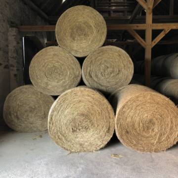
Heu zu verkaufen
Kremmen OT Staffelde
Rhinland Reitpark GmbH
@Rhinland-Reitpark
Heu
Empfänger lädt ab
Rundballen
Regenfrei
3 weitere...
B+

Haferstroh in Futterqualität für gesunde Pferde ...
Schollene
Guthof Mühlenfels
@Gutshof-Muehlenfels
Einstreu
Lieferant entlädt
Großballen
Regenfrei
3 weitere...
B+
Deprecated: Creation of dynamic property Zend_View_Helper_Ads::$adLink is deprecated in /var/www/stall-frei/htdocs/staging.stall-frei.de/library/Psf/View/Helper/Ads.php on line 108

Futtersack HeuToy, Fressbremse in pink
Mechtersen
STALL-FREIde Marketing
@STALL-FREI-Marketing
Stundenlange Beschäftigung die
Koliken vorbeugt, geringe Staubinhalation mit
steuerbarer Futterentnahme

Fruktan- und zuckerarmes Heu in Premiumqualität !
Schollene
Guthof Mühlenfels
@Gutshof-Muehlenfels
Heu
Empfänger lädt ab
Rundballen
Bio
Regenfrei
3 weitere...
B+

Fruktan- und zuckerarmes Premium Wiesenheu !
Schollene
Guthof Mühlenfels
@Gutshof-Muehlenfels
Heu
Empfänger lädt ab
Rundballen
Regenfrei
3 weitere...
B+
Leider kein Vorschaubild
Leider kein Vorschaubild
Biohafer zu verkaufen
Altmärkische Höhe OT Losse
Landwirtschaft H.Stoltenberg
@ReiterhofLosse
Futter
Empfänger lädt ab
Lose
Bio
Regenfrei
2 weitere...
B+

Heu aus neuer Ernte
Mechtersen
STALL-FREIde Marketing
@STALL-FREI-Marketing
Heulage und Pferdeheu aus der neuen Ernte findest du in unserem Futtermarkt
Leider kein Vorschaubild
Leider kein Vorschaubild
Bio-Luzerneheu aus qualifiziertem Biobetrieb
Altmärkische Höhe OT Losse
Landwirtschaft H.Stoltenberg
@ReiterhofLosse
Heu
Empfänger lädt ab
Großballen
Bio
2 weitere...
B+

Strohstrukturpellets
Warsow
Luca Grabeleu, Marquardt
@LucaGrabeleu
Einstreu
Empfänger lädt ab
Bigbag
Regenfrei
3 weitere...
B+

Heu und Stroh /Rundballen/Quaderballen
Sandersdorf
jule13
@Jule2024
Stroh
Lieferant entlädt
Rundballen
Regenfrei
3 weitere...
B+

Haferstroh 1.50m Ernte 25 Ausgezeichnete Qualität
Cavertitz
LWB Streubel
@Landwirtschaftsbetr.-Streubel
Stroh
Lieferant entlädt
Rundballen
Regenfrei
3 weitere...
B+
Pferdeheu 1.Schnitt Juli 2025/Rundballen 1.50m
Cavertitz
LWB Streubel
@Landwirtschaftsbetr.-Streubel
Heu
Lieferant entlädt
Rundballen
Bio
Regenfrei
3 weitere...
B+
Deprecated: Creation of dynamic property Zend_View::$pageCount is deprecated in /var/www/stall-frei/htdocs/staging.stall-frei.de/library/vendor/shardj/zf1-future/library/Zend/View/Abstract.php on line 308
Deprecated: Creation of dynamic property Zend_View::$itemCountPerPage is deprecated in /var/www/stall-frei/htdocs/staging.stall-frei.de/library/vendor/shardj/zf1-future/library/Zend/View/Abstract.php on line 308
Deprecated: Creation of dynamic property Zend_View::$first is deprecated in /var/www/stall-frei/htdocs/staging.stall-frei.de/library/vendor/shardj/zf1-future/library/Zend/View/Abstract.php on line 308
Deprecated: Creation of dynamic property Zend_View::$current is deprecated in /var/www/stall-frei/htdocs/staging.stall-frei.de/library/vendor/shardj/zf1-future/library/Zend/View/Abstract.php on line 308
Deprecated: Creation of dynamic property Zend_View::$last is deprecated in /var/www/stall-frei/htdocs/staging.stall-frei.de/library/vendor/shardj/zf1-future/library/Zend/View/Abstract.php on line 308
Deprecated: Creation of dynamic property Zend_View::$next is deprecated in /var/www/stall-frei/htdocs/staging.stall-frei.de/library/vendor/shardj/zf1-future/library/Zend/View/Abstract.php on line 308
Deprecated: Creation of dynamic property Zend_View::$pagesInRange is deprecated in /var/www/stall-frei/htdocs/staging.stall-frei.de/library/vendor/shardj/zf1-future/library/Zend/View/Abstract.php on line 308
Deprecated: Creation of dynamic property Zend_View::$firstPageInRange is deprecated in /var/www/stall-frei/htdocs/staging.stall-frei.de/library/vendor/shardj/zf1-future/library/Zend/View/Abstract.php on line 308
Deprecated: Creation of dynamic property Zend_View::$lastPageInRange is deprecated in /var/www/stall-frei/htdocs/staging.stall-frei.de/library/vendor/shardj/zf1-future/library/Zend/View/Abstract.php on line 308
Deprecated: Creation of dynamic property Zend_View::$currentItemCount is deprecated in /var/www/stall-frei/htdocs/staging.stall-frei.de/library/vendor/shardj/zf1-future/library/Zend/View/Abstract.php on line 308
Deprecated: Creation of dynamic property Zend_View::$totalItemCount is deprecated in /var/www/stall-frei/htdocs/staging.stall-frei.de/library/vendor/shardj/zf1-future/library/Zend/View/Abstract.php on line 308
Deprecated: Creation of dynamic property Zend_View::$firstItemNumber is deprecated in /var/www/stall-frei/htdocs/staging.stall-frei.de/library/vendor/shardj/zf1-future/library/Zend/View/Abstract.php on line 308
Deprecated: Creation of dynamic property Zend_View::$lastItemNumber is deprecated in /var/www/stall-frei/htdocs/staging.stall-frei.de/library/vendor/shardj/zf1-future/library/Zend/View/Abstract.php on line 308
Deprecated: Creation of dynamic property Zend_View::$router is deprecated in /var/www/stall-frei/htdocs/staging.stall-frei.de/library/vendor/shardj/zf1-future/library/Zend/View/Abstract.php on line 308
Deprecated: Creation of dynamic property Zend_View::$urlParams is deprecated in /var/www/stall-frei/htdocs/staging.stall-frei.de/library/vendor/shardj/zf1-future/library/Zend/View/Abstract.php on line 308
Deprecated: Creation of dynamic property Zend_View::$showAds is deprecated in /var/www/stall-frei/htdocs/staging.stall-frei.de/library/vendor/shardj/zf1-future/library/Zend/View/Abstract.php on line 308
Deprecated: Creation of dynamic property Zend_View::$objectIds is deprecated in /var/www/stall-frei/htdocs/staging.stall-frei.de/library/vendor/shardj/zf1-future/library/Zend/View/Abstract.php on line 308
Deprecated: Creation of dynamic property Zend_View::$showNavbar is deprecated in /var/www/stall-frei/htdocs/staging.stall-frei.de/library/vendor/shardj/zf1-future/library/Zend/View/Abstract.php on line 308
Deprecated: Creation of dynamic property Zend_View::$showBreadcrumb is deprecated in /var/www/stall-frei/htdocs/staging.stall-frei.de/library/vendor/shardj/zf1-future/library/Zend/View/Abstract.php on line 308
Deprecated: Creation of dynamic property Zend_View::$showFooter is deprecated in /var/www/stall-frei/htdocs/staging.stall-frei.de/library/vendor/shardj/zf1-future/library/Zend/View/Abstract.php on line 308
Deprecated: Creation of dynamic property Zend_View::$showInternalAds is deprecated in /var/www/stall-frei/htdocs/staging.stall-frei.de/library/vendor/shardj/zf1-future/library/Zend/View/Abstract.php on line 308
Deprecated: Creation of dynamic property Zend_View::$blNoContent is deprecated in /var/www/stall-frei/htdocs/staging.stall-frei.de/library/vendor/shardj/zf1-future/library/Zend/View/Abstract.php on line 308
Deprecated: Creation of dynamic property Zend_View::$sMetaDesc is deprecated in /var/www/stall-frei/htdocs/staging.stall-frei.de/library/vendor/shardj/zf1-future/library/Zend/View/Abstract.php on line 308
Deprecated: Creation of dynamic property Zend_View::$useGmaps is deprecated in /var/www/stall-frei/htdocs/staging.stall-frei.de/library/vendor/shardj/zf1-future/library/Zend/View/Abstract.php on line 308
Deprecated: Creation of dynamic property Zend_View::$touches is deprecated in /var/www/stall-frei/htdocs/staging.stall-frei.de/library/vendor/shardj/zf1-future/library/Zend/View/Abstract.php on line 308
Deprecated: Creation of dynamic property Zend_View::$oProject is deprecated in /var/www/stall-frei/htdocs/staging.stall-frei.de/library/vendor/shardj/zf1-future/library/Zend/View/Abstract.php on line 308
Deprecated: Creation of dynamic property Zend_View::$pageHeadline is deprecated in /var/www/stall-frei/htdocs/staging.stall-frei.de/library/vendor/shardj/zf1-future/library/Zend/View/Abstract.php on line 308
Deprecated: Creation of dynamic property Zend_View::$disableLocationField is deprecated in /var/www/stall-frei/htdocs/staging.stall-frei.de/library/vendor/shardj/zf1-future/library/Zend/View/Abstract.php on line 308
Deprecated: Creation of dynamic property Zend_View::$isSearch is deprecated in /var/www/stall-frei/htdocs/staging.stall-frei.de/library/vendor/shardj/zf1-future/library/Zend/View/Abstract.php on line 308
Deprecated: Creation of dynamic property Zend_View::$pageTitle is deprecated in /var/www/stall-frei/htdocs/staging.stall-frei.de/library/vendor/shardj/zf1-future/library/Zend/View/Abstract.php on line 308
Deprecated: Creation of dynamic property Psf_Form_Element_Text::$class is deprecated in /var/www/stall-frei/htdocs/staging.stall-frei.de/library/vendor/shardj/zf1-future/library/Zend/Form/Element.php on line 874
Deprecated: Creation of dynamic property Psf_Form_Element_Text::$size is deprecated in /var/www/stall-frei/htdocs/staging.stall-frei.de/library/vendor/shardj/zf1-future/library/Zend/Form/Element.php on line 874
Deprecated: Creation of dynamic property Psf_Form_Element_Text::$placeholder is deprecated in /var/www/stall-frei/htdocs/staging.stall-frei.de/library/vendor/shardj/zf1-future/library/Zend/Form/Element.php on line 874
Deprecated: Creation of dynamic property Psf_Form_Element_Hidden::$class is deprecated in /var/www/stall-frei/htdocs/staging.stall-frei.de/library/vendor/shardj/zf1-future/library/Zend/Form/Element.php on line 874
Deprecated: Creation of dynamic property Psf_Form_Element_Hidden::$class is deprecated in /var/www/stall-frei/htdocs/staging.stall-frei.de/library/vendor/shardj/zf1-future/library/Zend/Form/Element.php on line 874
Deprecated: Creation of dynamic property Psf_Form_Element_Hidden::$class is deprecated in /var/www/stall-frei/htdocs/staging.stall-frei.de/library/vendor/shardj/zf1-future/library/Zend/Form/Element.php on line 874
Deprecated: Creation of dynamic property Psf_Form_Element_Hidden::$class is deprecated in /var/www/stall-frei/htdocs/staging.stall-frei.de/library/vendor/shardj/zf1-future/library/Zend/Form/Element.php on line 874
Deprecated: Creation of dynamic property Psf_Form_Element_Select::$class is deprecated in /var/www/stall-frei/htdocs/staging.stall-frei.de/library/vendor/shardj/zf1-future/library/Zend/Form/Element.php on line 874
Deprecated: Creation of dynamic property Psf_Form_Element_Select::$class is deprecated in /var/www/stall-frei/htdocs/staging.stall-frei.de/library/vendor/shardj/zf1-future/library/Zend/Form/Element.php on line 874
Deprecated: Creation of dynamic property Psf_Form_Element_Select::$class is deprecated in /var/www/stall-frei/htdocs/staging.stall-frei.de/library/vendor/shardj/zf1-future/library/Zend/Form/Element.php on line 874
Deprecated: Creation of dynamic property Psf_Form_Element_Select::$class is deprecated in /var/www/stall-frei/htdocs/staging.stall-frei.de/library/vendor/shardj/zf1-future/library/Zend/Form/Element.php on line 874
Deprecated: Creation of dynamic property Zend_View::$sort is deprecated in /var/www/stall-frei/htdocs/staging.stall-frei.de/library/vendor/shardj/zf1-future/library/Zend/View/Abstract.php on line 308
Deprecated: Creation of dynamic property Zend_View::$searchLocation is deprecated in /var/www/stall-frei/htdocs/staging.stall-frei.de/library/vendor/shardj/zf1-future/library/Zend/View/Abstract.php on line 308
Deprecated: Creation of dynamic property Zend_View::$locationHint is deprecated in /var/www/stall-frei/htdocs/staging.stall-frei.de/library/vendor/shardj/zf1-future/library/Zend/View/Abstract.php on line 308
Psf_GeoCoder_Abstract::getLocation: Grüneberg Get Location CachedOrLive
Psf_GeoCoder_Abstract::getCachedOrLive: Grüneberg
Psf_GeoCoder_OpenCageData::makeApiRequest: response:
Array
(
[documentation] => https://opencagedata.com/api
[licenses] => Array
(
[0] => Array
(
[name] => see attribution guide
[url] => https://opencagedata.com/credits
)
)
[results] => Array
(
[0] => Array
(
[bounds] => Array
(
[northeast] => Array
(
[lat] => 52.8983585
[lng] => 13.2854893
)
[southwest] => Array
(
[lat] => 52.8354169
[lng] => 13.1930954
)
)
[components] => Array
(
[ISO_3166-1_alpha-2] => DE
[ISO_3166-1_alpha-3] => DEU
[ISO_3166-2] => Array
(
[0] => DE-BB
)
[_category] => place
[_normalized_city] => Grüneberg
[_type] => village
[continent] => Europe
[country] => Deutschland
[country_code] => de
[county] => Oberhavel
[municipality] => Löwenberger Land
[political_union] => European Union
[state] => Brandenburg
[state_code] => BB
[village] => Grüneberg
)
[confidence] => 7
[formatted] => Grüneberg, Brandenburg, Deutschland
[geometry] => Array
(
[lat] => 52.8730894
[lng] => 13.2224143
)
)
[1] => Array
(
[bounds] => Array
(
[northeast] => Array
(
[lat] => 49.7733706
[lng] => 6.7057039
)
[southwest] => Array
(
[lat] => 49.7732706
[lng] => 6.7056039
)
)
[components] => Array
(
[ISO_3166-1_alpha-2] => DE
[ISO_3166-1_alpha-3] => DEU
[ISO_3166-2] => Array
(
[0] => DE-RP
)
[_category] => natural/water
[_normalized_city] => Trier
[_type] => peak
[city] => Trier
[continent] => Europe
[country] => Deutschland
[country_code] => de
[municipality] => Trierweiler
[peak] => Grüneberg
[political_union] => European Union
[postcode] => 54318
[state] => Rheinland-Pfalz
[state_code] => RP
)
[confidence] => 9
[formatted] => Grüneberg, 54318 Trier, Deutschland
[geometry] => Array
(
[lat] => 49.7733206
[lng] => 6.7056539
)
)
[2] => Array
(
[bounds] => Array
(
[northeast] => Array
(
[lat] => 51.1688516
[lng] => 8.2003948
)
[southwest] => Array
(
[lat] => 51.1687516
[lng] => 8.2002948
)
)
[components] => Array
(
[ISO_3166-1_alpha-2] => DE
[ISO_3166-1_alpha-3] => DEU
[ISO_3166-2] => Array
(
[0] => DE-NW
)
[_category] => natural/water
[_normalized_city] => Schmallenberg
[_type] => peak
[continent] => Europe
[country] => Deutschland
[country_code] => de
[county] => Hochsauerlandkreis
[peak] => Grüneberg
[political_union] => European Union
[state] => Nordrhein-Westfalen
[state_code] => NW
[town] => Schmallenberg
)
[confidence] => 9
[formatted] => Grüneberg, Schmallenberg, Nordrhein-Westfalen, Deutschland
[geometry] => Array
(
[lat] => 51.1688016
[lng] => 8.2003448
)
)
[3] => Array
(
[bounds] => Array
(
[northeast] => Array
(
[lat] => 47.6761683
[lng] => 7.677011
)
[southwest] => Array
(
[lat] => 47.6760683
[lng] => 7.676911
)
)
[components] => Array
(
[ISO_3166-1_alpha-2] => DE
[ISO_3166-1_alpha-3] => DEU
[ISO_3166-2] => Array
(
[0] => DE-BW
)
[_category] => natural/water
[_normalized_city] => Kandern
[_type] => peak
[continent] => Europe
[country] => Deutschland
[country_code] => de
[county] => Landkreis Lörrach
[municipality] => VVG der Stadt Kandern
[peak] => Grüneberg
[political_union] => European Union
[postcode] => 79599
[state] => Baden-Württemberg
[state_code] => BW
[town] => Kandern
)
[confidence] => 9
[formatted] => Grüneberg, 79599 Kandern, Deutschland
[geometry] => Array
(
[lat] => 47.6761183
[lng] => 7.676961
)
)
[4] => Array
(
[bounds] => Array
(
[northeast] => Array
(
[lat] => 51.7902005
[lng] => 13.6328817
)
[southwest] => Array
(
[lat] => 51.7901005
[lng] => 13.6327817
)
)
[components] => Array
(
[ISO_3166-1_alpha-2] => DE
[ISO_3166-1_alpha-3] => DEU
[ISO_3166-2] => Array
(
[0] => DE-BB
)
[_category] => natural/water
[_normalized_city] => Heideblick
[_type] => peak
[continent] => Europe
[country] => Deutschland
[country_code] => de
[county] => Dahme-Spreewald
[municipality] => Heideblick
[peak] => Grüneberg
[political_union] => European Union
[state] => Brandenburg
[state_code] => BB
)
[confidence] => 9
[formatted] => Grüneberg, Heideblick, Brandenburg, Deutschland
[geometry] => Array
(
[lat] => 51.7901505
[lng] => 13.6328317
)
)
[5] => Array
(
[bounds] => Array
(
[northeast] => Array
(
[lat] => 51.3807235
[lng] => 14.0869374
)
[southwest] => Array
(
[lat] => 51.3407235
[lng] => 14.0469374
)
)
[components] => Array
(
[ISO_3166-1_alpha-2] => DE
[ISO_3166-1_alpha-3] => DEU
[ISO_3166-2] => Array
(
[0] => DE-SN
)
[_category] => place
[_normalized_city] => Bernsdorf
[_type] => hamlet
[continent] => Europe
[country] => Deutschland
[country_code] => de
[county] => Bautzen
[hamlet] => Grüneberg
[political_union] => European Union
[postcode] => 02994
[state] => Sachsen
[state_code] => SN
[town] => Bernsdorf
)
[confidence] => 7
[formatted] => Grüneberg, 02994 Bernsdorf, Deutschland
[geometry] => Array
(
[lat] => 51.3607235
[lng] => 14.0669374
)
)
[6] => Array
(
[bounds] => Array
(
[northeast] => Array
(
[lat] => 47.6865533
[lng] => 7.6910048
)
[southwest] => Array
(
[lat] => 47.6665533
[lng] => 7.6710048
)
)
[components] => Array
(
[ISO_3166-1_alpha-2] => DE
[ISO_3166-1_alpha-3] => DEU
[ISO_3166-2] => Array
(
[0] => DE-BW
)
[_category] => place
[_normalized_city] => Kandern
[_type] => hamlet
[continent] => Europe
[country] => Deutschland
[country_code] => de
[county] => Landkreis Lörrach
[locality] => Grüneberg
[municipality] => VVG der Stadt Kandern
[political_union] => European Union
[postcode] => 79400
[state] => Baden-Württemberg
[state_code] => BW
[town] => Kandern
[village] => Wollbach
)
[confidence] => 8
[formatted] => Grüneberg, 79400 Wollbach, Deutschland
[geometry] => Array
(
[lat] => 47.6765533
[lng] => 7.6810048
)
)
[7] => Array
(
[bounds] => Array
(
[northeast] => Array
(
[lat] => 50.6992708
[lng] => 11.5796119
)
[southwest] => Array
(
[lat] => 50.6991708
[lng] => 11.5795119
)
)
[components] => Array
(
[ISO_3166-1_alpha-2] => DE
[ISO_3166-1_alpha-3] => DEU
[ISO_3166-2] => Array
(
[0] => DE-TH
)
[_category] => natural/water
[_normalized_city] => Pößneck
[_type] => peak
[continent] => Europe
[country] => Deutschland
[country_code] => de
[county] => Saale-Orla-Kreis
[peak] => Gruneberg
[political_union] => European Union
[postcode] => 07381
[state] => Thüringen
[state_code] => TH
[town] => Pößneck
)
[confidence] => 9
[formatted] => Gruneberg, 07381 Pößneck, Deutschland
[geometry] => Array
(
[lat] => 50.6992208
[lng] => 11.5795619
)
)
[8] => Array
(
[components] => Array
(
[ISO_3166-1_alpha-2] => FR
[ISO_3166-1_alpha-3] => FRA
[ISO_3166-2] => Array
(
[0] => FR-OCC
[1] => FR-32
)
[_category] => road
[_normalized_city] => Condom
[_type] => road
[city] => Condom
[continent] => Europe
[country] => France
[country_code] => fr
[county] => Gers
[local_authority] => Communauté de communes de la Tenarèze
[political_union] => European Union
[postcode] => 32100
[road] => Avenue de Grunberg
[state] => Occitanie
[state_code] => OCC
)
[confidence] => 3
[formatted] => Avenue de Grunberg, 32100 Condom, France
[geometry] => Array
(
[lat] => 43.951196
[lng] => 0.372831
)
)
[9] => Array
(
[components] => Array
(
[ISO_3166-1_alpha-2] => FR
[ISO_3166-1_alpha-3] => FRA
[ISO_3166-2] => Array
(
[0] => FR-IDF
[1] => FR-92
)
[_category] => road
[_normalized_city] => Levallois-Perret
[_type] => road
[city] => Levallois-Perret
[continent] => Europe
[country] => France
[country_code] => fr
[county] => Hauts-de-Seine
[local_authority] => Métropole du Grand Paris
[political_union] => European Union
[postcode] => 92300
[road] => Rue Charles Deutschmann
[state] => Île-de-France
[state_code] => IDF
)
[confidence] => 2
[formatted] => Rue Charles Deutschmann, 92300 Levallois-Perret, France
[geometry] => Array
(
[lat] => 48.900049
[lng] => 2.2842
)
)
)
[status] => Array
(
[code] => 200
[message] => OK
)
[stay_informed] => Array
(
[blog] => https://blog.opencagedata.com
[mastodon] => https://en.osm.town/@opencage
)
[thanks] => For using an OpenCage API
[timestamp] => Array
(
[created_http] => Sun, 08 Feb 2026 07:31:45 GMT
[created_unix] => 1770535905
)
[total_results] => 10
)
Psf_GeoCoder_Abstract::convertLocationResult
{"documentation":"https:\/\/opencagedata.com\/api","licenses":[{"name":"see attribution guide","url":"https:\/\/opencagedata.com\/credits"}],"results":[{"bounds":{"northeast":{"lat":52.8983585,"lng":13.2854893},"southwest":{"lat":52.8354169,"lng":13.1930954}},"components":{"ISO_3166-1_alpha-2":"DE","ISO_3166-1_alpha-3":"DEU","ISO_3166-2":["DE-BB"],"_category":"place","_normalized_city":"Gr\u00fcneberg","_type":"village","continent":"Europe","country":"Deutschland","country_code":"de","county":"Oberhavel","municipality":"L\u00f6wenberger Land","political_union":"European Union","state":"Brandenburg","state_code":"BB","village":"Gr\u00fcneberg"},"confidence":7,"formatted":"Gr\u00fcneberg, Brandenburg, Deutschland","geometry":{"lat":52.8730894,"lng":13.2224143}},{"bounds":{"northeast":{"lat":49.7733706,"lng":6.7057039},"southwest":{"lat":49.7732706,"lng":6.7056039}},"components":{"ISO_3166-1_alpha-2":"DE","ISO_3166-1_alpha-3":"DEU","ISO_3166-2":["DE-RP"],"_category":"natural\/water","_normalized_city":"Trier","_type":"peak","city":"Trier","continent":"Europe","country":"Deutschland","country_code":"de","municipality":"Trierweiler","peak":"Gr\u00fcneberg","political_union":"European Union","postcode":"54318","state":"Rheinland-Pfalz","state_code":"RP"},"confidence":9,"formatted":"Gr\u00fcneberg, 54318 Trier, Deutschland","geometry":{"lat":49.7733206,"lng":6.7056539}},{"bounds":{"northeast":{"lat":51.1688516,"lng":8.2003948},"southwest":{"lat":51.1687516,"lng":8.2002948}},"components":{"ISO_3166-1_alpha-2":"DE","ISO_3166-1_alpha-3":"DEU","ISO_3166-2":["DE-NW"],"_category":"natural\/water","_normalized_city":"Schmallenberg","_type":"peak","continent":"Europe","country":"Deutschland","country_code":"de","county":"Hochsauerlandkreis","peak":"Gr\u00fcneberg","political_union":"European Union","state":"Nordrhein-Westfalen","state_code":"NW","town":"Schmallenberg"},"confidence":9,"formatted":"Gr\u00fcneberg, Schmallenberg, Nordrhein-Westfalen, Deutschland","geometry":{"lat":51.1688016,"lng":8.2003448}},{"bounds":{"northeast":{"lat":47.6761683,"lng":7.677011},"southwest":{"lat":47.6760683,"lng":7.676911}},"components":{"ISO_3166-1_alpha-2":"DE","ISO_3166-1_alpha-3":"DEU","ISO_3166-2":["DE-BW"],"_category":"natural\/water","_normalized_city":"Kandern","_type":"peak","continent":"Europe","country":"Deutschland","country_code":"de","county":"Landkreis L\u00f6rrach","municipality":"VVG der Stadt Kandern","peak":"Gr\u00fcneberg","political_union":"European Union","postcode":"79599","state":"Baden-W\u00fcrttemberg","state_code":"BW","town":"Kandern"},"confidence":9,"formatted":"Gr\u00fcneberg, 79599 Kandern, Deutschland","geometry":{"lat":47.6761183,"lng":7.676961}},{"bounds":{"northeast":{"lat":51.7902005,"lng":13.6328817},"southwest":{"lat":51.7901005,"lng":13.6327817}},"components":{"ISO_3166-1_alpha-2":"DE","ISO_3166-1_alpha-3":"DEU","ISO_3166-2":["DE-BB"],"_category":"natural\/water","_normalized_city":"Heideblick","_type":"peak","continent":"Europe","country":"Deutschland","country_code":"de","county":"Dahme-Spreewald","municipality":"Heideblick","peak":"Gr\u00fcneberg","political_union":"European Union","state":"Brandenburg","state_code":"BB"},"confidence":9,"formatted":"Gr\u00fcneberg, Heideblick, Brandenburg, Deutschland","geometry":{"lat":51.7901505,"lng":13.6328317}},{"bounds":{"northeast":{"lat":51.3807235,"lng":14.0869374},"southwest":{"lat":51.3407235,"lng":14.0469374}},"components":{"ISO_3166-1_alpha-2":"DE","ISO_3166-1_alpha-3":"DEU","ISO_3166-2":["DE-SN"],"_category":"place","_normalized_city":"Bernsdorf","_type":"hamlet","continent":"Europe","country":"Deutschland","country_code":"de","county":"Bautzen","hamlet":"Gr\u00fcneberg","political_union":"European Union","postcode":"02994","state":"Sachsen","state_code":"SN","town":"Bernsdorf"},"confidence":7,"formatted":"Gr\u00fcneberg, 02994 Bernsdorf, Deutschland","geometry":{"lat":51.3607235,"lng":14.0669374}},{"bounds":{"northeast":{"lat":47.6865533,"lng":7.6910048},"southwest":{"lat":47.6665533,"lng":7.6710048}},"components":{"ISO_3166-1_alpha-2":"DE","ISO_3166-1_alpha-3":"DEU","ISO_3166-2":["DE-BW"],"_category":"place","_normalized_city":"Kandern","_type":"hamlet","continent":"Europe","country":"Deutschland","country_code":"de","county":"Landkreis L\u00f6rrach","locality":"Gr\u00fcneberg","municipality":"VVG der Stadt Kandern","political_union":"European Union","postcode":"79400","state":"Baden-W\u00fcrttemberg","state_code":"BW","town":"Kandern","village":"Wollbach"},"confidence":8,"formatted":"Gr\u00fcneberg, 79400 Wollbach, Deutschland","geometry":{"lat":47.6765533,"lng":7.6810048}},{"bounds":{"northeast":{"lat":50.6992708,"lng":11.5796119},"southwest":{"lat":50.6991708,"lng":11.5795119}},"components":{"ISO_3166-1_alpha-2":"DE","ISO_3166-1_alpha-3":"DEU","ISO_3166-2":["DE-TH"],"_category":"natural\/water","_normalized_city":"P\u00f6\u00dfneck","_type":"peak","continent":"Europe","country":"Deutschland","country_code":"de","county":"Saale-Orla-Kreis","peak":"Gruneberg","political_union":"European Union","postcode":"07381","state":"Th\u00fcringen","state_code":"TH","town":"P\u00f6\u00dfneck"},"confidence":9,"formatted":"Gruneberg, 07381 P\u00f6\u00dfneck, Deutschland","geometry":{"lat":50.6992208,"lng":11.5795619}},{"components":{"ISO_3166-1_alpha-2":"FR","ISO_3166-1_alpha-3":"FRA","ISO_3166-2":["FR-OCC","FR-32"],"_category":"road","_normalized_city":"Condom","_type":"road","city":"Condom","continent":"Europe","country":"France","country_code":"fr","county":"Gers","local_authority":"Communaut\u00e9 de communes de la Tenar\u00e8ze","political_union":"European Union","postcode":"32100","road":"Avenue de Grunberg","state":"Occitanie","state_code":"OCC"},"confidence":3,"formatted":"Avenue de Grunberg, 32100 Condom, France","geometry":{"lat":43.951196,"lng":0.372831}},{"components":{"ISO_3166-1_alpha-2":"FR","ISO_3166-1_alpha-3":"FRA","ISO_3166-2":["FR-IDF","FR-92"],"_category":"road","_normalized_city":"Levallois-Perret","_type":"road","city":"Levallois-Perret","continent":"Europe","country":"France","country_code":"fr","county":"Hauts-de-Seine","local_authority":"M\u00e9tropole du Grand Paris","political_union":"European Union","postcode":"92300","road":"Rue Charles Deutschmann","state":"\u00cele-de-France","state_code":"IDF"},"confidence":2,"formatted":"Rue Charles Deutschmann, 92300 Levallois-Perret, France","geometry":{"lat":48.900049,"lng":2.2842}}],"status":{"code":200,"message":"OK"},"stay_informed":{"blog":"https:\/\/blog.opencagedata.com","mastodon":"https:\/\/en.osm.town\/@opencage"},"thanks":"For using an OpenCage API","timestamp":{"created_http":"Sun, 08 Feb 2026 07:31:45 GMT","created_unix":1770535905},"total_results":10}Array
(
[0] => stdClass Object
(
[bounds] => stdClass Object
(
[northeast] => stdClass Object
(
[lat] => 52.8983585
[lng] => 13.2854893
)
[southwest] => stdClass Object
(
[lat] => 52.8354169
[lng] => 13.1930954
)
)
[components] => stdClass Object
(
[ISO_3166-1_alpha-2] => DE
[ISO_3166-1_alpha-3] => DEU
[ISO_3166-2] => Array
(
[0] => DE-BB
)
[_category] => place
[_normalized_city] => Grüneberg
[_type] => village
[continent] => Europe
[country] => Deutschland
[country_code] => de
[county] => Oberhavel
[municipality] => Löwenberger Land
[political_union] => European Union
[state] => Brandenburg
[state_code] => BB
[village] => Grüneberg
)
[confidence] => 7
[formatted] => Grüneberg, Brandenburg, Deutschland
[geometry] => stdClass Object
(
[lat] => 52.8730894
[lng] => 13.2224143
)
)
[1] => stdClass Object
(
[bounds] => stdClass Object
(
[northeast] => stdClass Object
(
[lat] => 49.7733706
[lng] => 6.7057039
)
[southwest] => stdClass Object
(
[lat] => 49.7732706
[lng] => 6.7056039
)
)
[components] => stdClass Object
(
[ISO_3166-1_alpha-2] => DE
[ISO_3166-1_alpha-3] => DEU
[ISO_3166-2] => Array
(
[0] => DE-RP
)
[_category] => natural/water
[_normalized_city] => Trier
[_type] => peak
[city] => Trier
[continent] => Europe
[country] => Deutschland
[country_code] => de
[municipality] => Trierweiler
[peak] => Grüneberg
[political_union] => European Union
[postcode] => 54318
[state] => Rheinland-Pfalz
[state_code] => RP
)
[confidence] => 9
[formatted] => Grüneberg, 54318 Trier, Deutschland
[geometry] => stdClass Object
(
[lat] => 49.7733206
[lng] => 6.7056539
)
)
[2] => stdClass Object
(
[bounds] => stdClass Object
(
[northeast] => stdClass Object
(
[lat] => 51.1688516
[lng] => 8.2003948
)
[southwest] => stdClass Object
(
[lat] => 51.1687516
[lng] => 8.2002948
)
)
[components] => stdClass Object
(
[ISO_3166-1_alpha-2] => DE
[ISO_3166-1_alpha-3] => DEU
[ISO_3166-2] => Array
(
[0] => DE-NW
)
[_category] => natural/water
[_normalized_city] => Schmallenberg
[_type] => peak
[continent] => Europe
[country] => Deutschland
[country_code] => de
[county] => Hochsauerlandkreis
[peak] => Grüneberg
[political_union] => European Union
[state] => Nordrhein-Westfalen
[state_code] => NW
[town] => Schmallenberg
)
[confidence] => 9
[formatted] => Grüneberg, Schmallenberg, Nordrhein-Westfalen, Deutschland
[geometry] => stdClass Object
(
[lat] => 51.1688016
[lng] => 8.2003448
)
)
[3] => stdClass Object
(
[bounds] => stdClass Object
(
[northeast] => stdClass Object
(
[lat] => 47.6761683
[lng] => 7.677011
)
[southwest] => stdClass Object
(
[lat] => 47.6760683
[lng] => 7.676911
)
)
[components] => stdClass Object
(
[ISO_3166-1_alpha-2] => DE
[ISO_3166-1_alpha-3] => DEU
[ISO_3166-2] => Array
(
[0] => DE-BW
)
[_category] => natural/water
[_normalized_city] => Kandern
[_type] => peak
[continent] => Europe
[country] => Deutschland
[country_code] => de
[county] => Landkreis Lörrach
[municipality] => VVG der Stadt Kandern
[peak] => Grüneberg
[political_union] => European Union
[postcode] => 79599
[state] => Baden-Württemberg
[state_code] => BW
[town] => Kandern
)
[confidence] => 9
[formatted] => Grüneberg, 79599 Kandern, Deutschland
[geometry] => stdClass Object
(
[lat] => 47.6761183
[lng] => 7.676961
)
)
[4] => stdClass Object
(
[bounds] => stdClass Object
(
[northeast] => stdClass Object
(
[lat] => 51.7902005
[lng] => 13.6328817
)
[southwest] => stdClass Object
(
[lat] => 51.7901005
[lng] => 13.6327817
)
)
[components] => stdClass Object
(
[ISO_3166-1_alpha-2] => DE
[ISO_3166-1_alpha-3] => DEU
[ISO_3166-2] => Array
(
[0] => DE-BB
)
[_category] => natural/water
[_normalized_city] => Heideblick
[_type] => peak
[continent] => Europe
[country] => Deutschland
[country_code] => de
[county] => Dahme-Spreewald
[municipality] => Heideblick
[peak] => Grüneberg
[political_union] => European Union
[state] => Brandenburg
[state_code] => BB
)
[confidence] => 9
[formatted] => Grüneberg, Heideblick, Brandenburg, Deutschland
[geometry] => stdClass Object
(
[lat] => 51.7901505
[lng] => 13.6328317
)
)
[5] => stdClass Object
(
[bounds] => stdClass Object
(
[northeast] => stdClass Object
(
[lat] => 51.3807235
[lng] => 14.0869374
)
[southwest] => stdClass Object
(
[lat] => 51.3407235
[lng] => 14.0469374
)
)
[components] => stdClass Object
(
[ISO_3166-1_alpha-2] => DE
[ISO_3166-1_alpha-3] => DEU
[ISO_3166-2] => Array
(
[0] => DE-SN
)
[_category] => place
[_normalized_city] => Bernsdorf
[_type] => hamlet
[continent] => Europe
[country] => Deutschland
[country_code] => de
[county] => Bautzen
[hamlet] => Grüneberg
[political_union] => European Union
[postcode] => 02994
[state] => Sachsen
[state_code] => SN
[town] => Bernsdorf
)
[confidence] => 7
[formatted] => Grüneberg, 02994 Bernsdorf, Deutschland
[geometry] => stdClass Object
(
[lat] => 51.3607235
[lng] => 14.0669374
)
)
[6] => stdClass Object
(
[bounds] => stdClass Object
(
[northeast] => stdClass Object
(
[lat] => 47.6865533
[lng] => 7.6910048
)
[southwest] => stdClass Object
(
[lat] => 47.6665533
[lng] => 7.6710048
)
)
[components] => stdClass Object
(
[ISO_3166-1_alpha-2] => DE
[ISO_3166-1_alpha-3] => DEU
[ISO_3166-2] => Array
(
[0] => DE-BW
)
[_category] => place
[_normalized_city] => Kandern
[_type] => hamlet
[continent] => Europe
[country] => Deutschland
[country_code] => de
[county] => Landkreis Lörrach
[locality] => Grüneberg
[municipality] => VVG der Stadt Kandern
[political_union] => European Union
[postcode] => 79400
[state] => Baden-Württemberg
[state_code] => BW
[town] => Kandern
[village] => Wollbach
)
[confidence] => 8
[formatted] => Grüneberg, 79400 Wollbach, Deutschland
[geometry] => stdClass Object
(
[lat] => 47.6765533
[lng] => 7.6810048
)
)
[7] => stdClass Object
(
[bounds] => stdClass Object
(
[northeast] => stdClass Object
(
[lat] => 50.6992708
[lng] => 11.5796119
)
[southwest] => stdClass Object
(
[lat] => 50.6991708
[lng] => 11.5795119
)
)
[components] => stdClass Object
(
[ISO_3166-1_alpha-2] => DE
[ISO_3166-1_alpha-3] => DEU
[ISO_3166-2] => Array
(
[0] => DE-TH
)
[_category] => natural/water
[_normalized_city] => Pößneck
[_type] => peak
[continent] => Europe
[country] => Deutschland
[country_code] => de
[county] => Saale-Orla-Kreis
[peak] => Gruneberg
[political_union] => European Union
[postcode] => 07381
[state] => Thüringen
[state_code] => TH
[town] => Pößneck
)
[confidence] => 9
[formatted] => Gruneberg, 07381 Pößneck, Deutschland
[geometry] => stdClass Object
(
[lat] => 50.6992208
[lng] => 11.5795619
)
)
[8] => stdClass Object
(
[components] => stdClass Object
(
[ISO_3166-1_alpha-2] => FR
[ISO_3166-1_alpha-3] => FRA
[ISO_3166-2] => Array
(
[0] => FR-OCC
[1] => FR-32
)
[_category] => road
[_normalized_city] => Condom
[_type] => road
[city] => Condom
[continent] => Europe
[country] => France
[country_code] => fr
[county] => Gers
[local_authority] => Communauté de communes de la Tenarèze
[political_union] => European Union
[postcode] => 32100
[road] => Avenue de Grunberg
[state] => Occitanie
[state_code] => OCC
)
[confidence] => 3
[formatted] => Avenue de Grunberg, 32100 Condom, France
[geometry] => stdClass Object
(
[lat] => 43.951196
[lng] => 0.372831
)
)
[9] => stdClass Object
(
[components] => stdClass Object
(
[ISO_3166-1_alpha-2] => FR
[ISO_3166-1_alpha-3] => FRA
[ISO_3166-2] => Array
(
[0] => FR-IDF
[1] => FR-92
)
[_category] => road
[_normalized_city] => Levallois-Perret
[_type] => road
[city] => Levallois-Perret
[continent] => Europe
[country] => France
[country_code] => fr
[county] => Hauts-de-Seine
[local_authority] => Métropole du Grand Paris
[political_union] => European Union
[postcode] => 92300
[road] => Rue Charles Deutschmann
[state] => Île-de-France
[state_code] => IDF
)
[confidence] => 2
[formatted] => Rue Charles Deutschmann, 92300 Levallois-Perret, France
[geometry] => stdClass Object
(
[lat] => 48.900049
[lng] => 2.2842
)
)
)
Psf_GeoCoder_OpenCageData::getKeyMap: 0
stdClass Object
(
    [bounds] => stdClass Object
        (
            [northeast] => stdClass Object
                (
                    [lat] => 52.8983585
                    [lng] => 13.2854893
                )

            [southwest] => stdClass Object
                (
                    [lat] => 52.8354169
                    [lng] => 13.1930954
                )

        )

    [components] => stdClass Object
        (
            [ISO_3166-1_alpha-2] => DE
            [ISO_3166-1_alpha-3] => DEU
            [ISO_3166-2] => Array
                (
                    [0] => DE-BB
                )

            [_category] => place
            [_normalized_city] => Grüneberg
            [_type] => village
            [continent] => Europe
            [country] => Deutschland
            [country_code] => de
            [county] => Oberhavel
            [municipality] => Löwenberger Land
            [political_union] => European Union
            [state] => Brandenburg
            [state_code] => BB
            [village] => Grüneberg
        )

    [confidence] => 7
    [formatted] => Grüneberg, Brandenburg, Deutschland
    [geometry] => stdClass Object
        (
            [lat] => 52.8730894
            [lng] => 13.2224143
        )

)
Psf_GeoCoder_OpenCageData::getCounty: Oberhavel
Psf_GeoCoder_OpenCageData::addMissingData REFETCH!
Array
(
    [address] => Grüneberg, Brandenburg, Deutschland
    [type] => village
    [street] =>
    [city] => Grüneberg
    [county] => Oberhavel
    [state] => Brandenburg
    [zip] =>
    [country] => Deutschland
    [suburb] =>
    [countrycode] => de
    [latitude] => 52.8730894
    [longitude] => 13.2224143
    [accuracy] => 1
    [confidence] => 7
    [bounds] => stdClass Object
        (
            [northeast] => stdClass Object
                (
                    [lat] => 52.8983585
                    [lng] => 13.2854893
                )

            [southwest] => stdClass Object
                (
                    [lat] => 52.8354169
                    [lng] => 13.1930954
                )

        )

)
reformat!
Array
(
    [address] => Grüneberg, Brandenburg, Deutschland
    [type] => village
    [street] =>
    [city] => Grüneberg
    [county] => Oberhavel
    [state] => Brandenburg
    [zip] =>
    [country] => Deutschland
    [suburb] =>
    [countrycode] => de
    [latitude] => 52.8730894
    [longitude] => 13.2224143
    [accuracy] => 1
    [confidence] => 7
    [bounds] => stdClass Object
        (
            [northeast] => stdClass Object
                (
                    [lat] => 52.8983585
                    [lng] => 13.2854893
                )

            [southwest] => stdClass Object
                (
                    [lat] => 52.8354169
                    [lng] => 13.1930954
                )

        )

    [place] => Grüneberg, Brandenburg
    [hash] => d6947e119462ff5882cdaee0c9481261
)
Psf_GeoCoder_OpenCageData::getKeyMap: 1
stdClass Object
(
    [bounds] => stdClass Object
        (
            [northeast] => stdClass Object
                (
                    [lat] => 49.7733706
                    [lng] => 6.7057039
                )

            [southwest] => stdClass Object
                (
                    [lat] => 49.7732706
                    [lng] => 6.7056039
                )

        )

    [components] => stdClass Object
        (
            [ISO_3166-1_alpha-2] => DE
            [ISO_3166-1_alpha-3] => DEU
            [ISO_3166-2] => Array
                (
                    [0] => DE-RP
                )

            [_category] => natural/water
            [_normalized_city] => Trier
            [_type] => peak
            [city] => Trier
            [continent] => Europe
            [country] => Deutschland
            [country_code] => de
            [municipality] => Trierweiler
            [peak] => Grüneberg
            [political_union] => European Union
            [postcode] => 54318
            [state] => Rheinland-Pfalz
            [state_code] => RP
        )

    [confidence] => 9
    [formatted] => Grüneberg, 54318 Trier, Deutschland
    [geometry] => stdClass Object
        (
            [lat] => 49.7733206
            [lng] => 6.7056539
        )

)
Psf_GeoCoder_OpenCageData::getCounty: Trier
Psf_GeoCoder_OpenCageData::addMissingData REFETCH!
Array
(
    [address] => Grüneberg, 54318 Trier, Deutschland
    [type] => peak
    [street] =>
    [city] => Trier
    [county] => Trier
    [state] => Rheinland-Pfalz
    [zip] => 54318
    [country] => Deutschland
    [suburb] =>
    [countrycode] => de
    [latitude] => 49.7733206
    [longitude] => 6.7056539
    [accuracy] => 1
    [confidence] => 9
    [bounds] => stdClass Object
        (
            [northeast] => stdClass Object
                (
                    [lat] => 49.7733706
                    [lng] => 6.7057039
                )

            [southwest] => stdClass Object
                (
                    [lat] => 49.7732706
                    [lng] => 6.7056039
                )

        )

)
reformat!
Array
(
    [address] => Grüneberg, 54318 Trier, Deutschland
    [type] => peak
    [street] =>
    [city] => Trier
    [county] => Trier
    [state] => Rheinland-Pfalz
    [zip] => 54318
    [country] => Deutschland
    [suburb] =>
    [countrycode] => de
    [latitude] => 49.7733206
    [longitude] => 6.7056539
    [accuracy] => 1
    [confidence] => 9
    [bounds] => stdClass Object
        (
            [northeast] => stdClass Object
                (
                    [lat] => 49.7733706
                    [lng] => 6.7057039
                )

            [southwest] => stdClass Object
                (
                    [lat] => 49.7732706
                    [lng] => 6.7056039
                )

        )

    [place] => 54318 Trier, Rheinland-Pfalz
    [hash] => a7763c7e7070b0161871678085cf3176
)
Psf_GeoCoder_OpenCageData::getKeyMap: 2
stdClass Object
(
    [bounds] => stdClass Object
        (
            [northeast] => stdClass Object
                (
                    [lat] => 51.1688516
                    [lng] => 8.2003948
                )

            [southwest] => stdClass Object
                (
                    [lat] => 51.1687516
                    [lng] => 8.2002948
                )

        )

    [components] => stdClass Object
        (
            [ISO_3166-1_alpha-2] => DE
            [ISO_3166-1_alpha-3] => DEU
            [ISO_3166-2] => Array
                (
                    [0] => DE-NW
                )

            [_category] => natural/water
            [_normalized_city] => Schmallenberg
            [_type] => peak
            [continent] => Europe
            [country] => Deutschland
            [country_code] => de
            [county] => Hochsauerlandkreis
            [peak] => Grüneberg
            [political_union] => European Union
            [state] => Nordrhein-Westfalen
            [state_code] => NW
            [town] => Schmallenberg
        )

    [confidence] => 9
    [formatted] => Grüneberg, Schmallenberg, Nordrhein-Westfalen, Deutschland
    [geometry] => stdClass Object
        (
            [lat] => 51.1688016
            [lng] => 8.2003448
        )

)
Psf_GeoCoder_OpenCageData::getCounty: Hochsauerlandkreis
Psf_GeoCoder_OpenCageData::addMissingData REFETCH!
Array
(
    [address] => Grüneberg, Schmallenberg, Nordrhein-Westfalen, Deutschland
    [type] => peak
    [street] =>
    [city] => Schmallenberg
    [county] => Hochsauerlandkreis
    [state] => Nordrhein-Westfalen
    [zip] =>
    [country] => Deutschland
    [suburb] =>
    [countrycode] => de
    [latitude] => 51.1688016
    [longitude] => 8.2003448
    [accuracy] => 1
    [confidence] => 9
    [bounds] => stdClass Object
        (
            [northeast] => stdClass Object
                (
                    [lat] => 51.1688516
                    [lng] => 8.2003948
                )

            [southwest] => stdClass Object
                (
                    [lat] => 51.1687516
                    [lng] => 8.2002948
                )

        )

)
reformat!
Array
(
    [address] => Grüneberg, Schmallenberg, Nordrhein-Westfalen, Deutschland
    [type] => peak
    [street] =>
    [city] => Schmallenberg
    [county] => Hochsauerlandkreis
    [state] => Nordrhein-Westfalen
    [zip] =>
    [country] => Deutschland
    [suburb] =>
    [countrycode] => de
    [latitude] => 51.1688016
    [longitude] => 8.2003448
    [accuracy] => 1
    [confidence] => 9
    [bounds] => stdClass Object
        (
            [northeast] => stdClass Object
                (
                    [lat] => 51.1688516
                    [lng] => 8.2003948
                )

            [southwest] => stdClass Object
                (
                    [lat] => 51.1687516
                    [lng] => 8.2002948
                )

        )

    [place] => Schmallenberg, Nordrhein-Westfalen
    [hash] => bcd55617eade3b599517d34ee5f25686
)
Psf_GeoCoder_OpenCageData::getKeyMap: 3
stdClass Object
(
    [bounds] => stdClass Object
        (
            [northeast] => stdClass Object
                (
                    [lat] => 47.6761683
                    [lng] => 7.677011
                )

            [southwest] => stdClass Object
                (
                    [lat] => 47.6760683
                    [lng] => 7.676911
                )

        )

    [components] => stdClass Object
        (
            [ISO_3166-1_alpha-2] => DE
            [ISO_3166-1_alpha-3] => DEU
            [ISO_3166-2] => Array
                (
                    [0] => DE-BW
                )

            [_category] => natural/water
            [_normalized_city] => Kandern
            [_type] => peak
            [continent] => Europe
            [country] => Deutschland
            [country_code] => de
            [county] => Landkreis Lörrach
            [municipality] => VVG der Stadt Kandern
            [peak] => Grüneberg
            [political_union] => European Union
            [postcode] => 79599
            [state] => Baden-Württemberg
            [state_code] => BW
            [town] => Kandern
        )

    [confidence] => 9
    [formatted] => Grüneberg, 79599 Kandern, Deutschland
    [geometry] => stdClass Object
        (
            [lat] => 47.6761183
            [lng] => 7.676961
        )

)
Psf_GeoCoder_OpenCageData::getCounty: Lörrach
Psf_GeoCoder_OpenCageData::addMissingData REFETCH!
Array
(
    [address] => Grüneberg, 79599 Kandern, Deutschland
    [type] => peak
    [street] =>
    [city] => Kandern
    [county] => Lörrach
    [state] => Baden-Württemberg
    [zip] => 79599
    [country] => Deutschland
    [suburb] =>
    [countrycode] => de
    [latitude] => 47.6761183
    [longitude] => 7.676961
    [accuracy] => 1
    [confidence] => 9
    [bounds] => stdClass Object
        (
            [northeast] => stdClass Object
                (
                    [lat] => 47.6761683
                    [lng] => 7.677011
                )

            [southwest] => stdClass Object
                (
                    [lat] => 47.6760683
                    [lng] => 7.676911
                )

        )

)
reformat!
Array
(
    [address] => Grüneberg, 79599 Kandern, Deutschland
    [type] => peak
    [street] =>
    [city] => Kandern
    [county] => Lörrach
    [state] => Baden-Württemberg
    [zip] => 79599
    [country] => Deutschland
    [suburb] =>
    [countrycode] => de
    [latitude] => 47.6761183
    [longitude] => 7.676961
    [accuracy] => 1
    [confidence] => 9
    [bounds] => stdClass Object
        (
            [northeast] => stdClass Object
                (
                    [lat] => 47.6761683
                    [lng] => 7.677011
                )

            [southwest] => stdClass Object
                (
                    [lat] => 47.6760683
                    [lng] => 7.676911
                )

        )

    [place] => 79599 Kandern, Baden-Württemberg
    [hash] => fa09a5af51457ce3e15002a36b1c25df
)
Psf_GeoCoder_OpenCageData::getKeyMap: 4
stdClass Object
(
    [bounds] => stdClass Object
        (
            [northeast] => stdClass Object
                (
                    [lat] => 51.7902005
                    [lng] => 13.6328817
                )

            [southwest] => stdClass Object
                (
                    [lat] => 51.7901005
                    [lng] => 13.6327817
                )

        )

    [components] => stdClass Object
        (
            [ISO_3166-1_alpha-2] => DE
            [ISO_3166-1_alpha-3] => DEU
            [ISO_3166-2] => Array
                (
                    [0] => DE-BB
                )

            [_category] => natural/water
            [_normalized_city] => Heideblick
            [_type] => peak
            [continent] => Europe
            [country] => Deutschland
            [country_code] => de
            [county] => Dahme-Spreewald
            [municipality] => Heideblick
            [peak] => Grüneberg
            [political_union] => European Union
            [state] => Brandenburg
            [state_code] => BB
        )

    [confidence] => 9
    [formatted] => Grüneberg, Heideblick, Brandenburg, Deutschland
    [geometry] => stdClass Object
        (
            [lat] => 51.7901505
            [lng] => 13.6328317
        )

)
Psf_GeoCoder_OpenCageData::getCounty: Dahme-Spreewald
Psf_GeoCoder_OpenCageData::addMissingData REFETCH!
Array
(
    [address] => Grüneberg, Heideblick, Brandenburg, Deutschland
    [type] => peak
    [street] =>
    [city] =>
    [county] => Dahme-Spreewald
    [state] => Brandenburg
    [zip] =>
    [country] => Deutschland
    [suburb] =>
    [countrycode] => de
    [latitude] => 51.7901505
    [longitude] => 13.6328317
    [accuracy] => 1
    [confidence] => 9
    [bounds] => stdClass Object
        (
            [northeast] => stdClass Object
                (
                    [lat] => 51.7902005
                    [lng] => 13.6328817
                )

            [southwest] => stdClass Object
                (
                    [lat] => 51.7901005
                    [lng] => 13.6327817
                )

        )

)
reformat!
Array
(
    [address] => Grüneberg, Heideblick, Brandenburg, Deutschland
    [type] => peak
    [street] =>
    [city] =>
    [county] => Dahme-Spreewald
    [state] => Brandenburg
    [zip] =>
    [country] => Deutschland
    [suburb] =>
    [countrycode] => de
    [latitude] => 51.7901505
    [longitude] => 13.6328317
    [accuracy] => 1
    [confidence] => 9
    [bounds] => stdClass Object
        (
            [northeast] => stdClass Object
                (
                    [lat] => 51.7902005
                    [lng] => 13.6328817
                )

            [southwest] => stdClass Object
                (
                    [lat] => 51.7901005
                    [lng] => 13.6327817
                )

        )

    [place] => , Brandenburg
    [hash] => b6ea5c7d00a7bd9cfe24eaec64ca789c
)
Psf_GeoCoder_OpenCageData::getKeyMap: 5
stdClass Object
(
    [bounds] => stdClass Object
        (
            [northeast] => stdClass Object
                (
                    [lat] => 51.3807235
                    [lng] => 14.0869374
                )

            [southwest] => stdClass Object
                (
                    [lat] => 51.3407235
                    [lng] => 14.0469374
                )

        )

    [components] => stdClass Object
        (
            [ISO_3166-1_alpha-2] => DE
            [ISO_3166-1_alpha-3] => DEU
            [ISO_3166-2] => Array
                (
                    [0] => DE-SN
                )

            [_category] => place
            [_normalized_city] => Bernsdorf
            [_type] => hamlet
            [continent] => Europe
            [country] => Deutschland
            [country_code] => de
            [county] => Bautzen
            [hamlet] => Grüneberg
            [political_union] => European Union
            [postcode] => 02994
            [state] => Sachsen
            [state_code] => SN
            [town] => Bernsdorf
        )

    [confidence] => 7
    [formatted] => Grüneberg, 02994 Bernsdorf, Deutschland
    [geometry] => stdClass Object
        (
            [lat] => 51.3607235
            [lng] => 14.0669374
        )

)
Psf_GeoCoder_OpenCageData::getCounty: Bautzen
Psf_GeoCoder_OpenCageData::addMissingData REFETCH!
Array
(
    [address] => Grüneberg, 02994 Bernsdorf, Deutschland
    [type] => hamlet
    [street] => Grüneberg
    [city] => Bernsdorf
    [county] => Bautzen
    [state] => Sachsen
    [zip] => 02994
    [country] => Deutschland
    [suburb] =>
    [countrycode] => de
    [latitude] => 51.3607235
    [longitude] => 14.0669374
    [accuracy] => 1
    [confidence] => 7
    [bounds] => stdClass Object
        (
            [northeast] => stdClass Object
                (
                    [lat] => 51.3807235
                    [lng] => 14.0869374
                )

            [southwest] => stdClass Object
                (
                    [lat] => 51.3407235
                    [lng] => 14.0469374
                )

        )

)
reformat!
Array
(
    [address] => Grüneberg, 02994 Bernsdorf, Deutschland
    [type] => hamlet
    [street] => Grüneberg
    [city] => Bernsdorf
    [county] => Bautzen
    [state] => Sachsen
    [zip] => 02994
    [country] => Deutschland
    [suburb] =>
    [countrycode] => de
    [latitude] => 51.3607235
    [longitude] => 14.0669374
    [accuracy] => 1
    [confidence] => 7
    [bounds] => stdClass Object
        (
            [northeast] => stdClass Object
                (
                    [lat] => 51.3807235
                    [lng] => 14.0869374
                )

            [southwest] => stdClass Object
                (
                    [lat] => 51.3407235
                    [lng] => 14.0469374
                )

        )

    [place] => Grüneberg, 02994 Bernsdorf, Sachsen
    [hash] => 59ed775246f38454649462e2d8d54509
)
Psf_GeoCoder_OpenCageData::getKeyMap: 6
stdClass Object
(
    [bounds] => stdClass Object
        (
            [northeast] => stdClass Object
                (
                    [lat] => 47.6865533
                    [lng] => 7.6910048
                )

            [southwest] => stdClass Object
                (
                    [lat] => 47.6665533
                    [lng] => 7.6710048
                )

        )

    [components] => stdClass Object
        (
            [ISO_3166-1_alpha-2] => DE
            [ISO_3166-1_alpha-3] => DEU
            [ISO_3166-2] => Array
                (
                    [0] => DE-BW
                )

            [_category] => place
            [_normalized_city] => Kandern
            [_type] => hamlet
            [continent] => Europe
            [country] => Deutschland
            [country_code] => de
            [county] => Landkreis Lörrach
            [locality] => Grüneberg
            [municipality] => VVG der Stadt Kandern
            [political_union] => European Union
            [postcode] => 79400
            [state] => Baden-Württemberg
            [state_code] => BW
            [town] => Kandern
            [village] => Wollbach
        )

    [confidence] => 8
    [formatted] => Grüneberg, 79400 Wollbach, Deutschland
    [geometry] => stdClass Object
        (
            [lat] => 47.6765533
            [lng] => 7.6810048
        )

)
Psf_GeoCoder_OpenCageData::getCounty: Lörrach
Psf_GeoCoder_OpenCageData::addMissingData REFETCH!
Array
(
    [address] => Grüneberg, 79400 Wollbach, Deutschland
    [type] => hamlet
    [street] =>
    [city] => Kandern
    [county] => Lörrach
    [state] => Baden-Württemberg
    [zip] => 79400
    [country] => Deutschland
    [suburb] =>
    [countrycode] => de
    [latitude] => 47.6765533
    [longitude] => 7.6810048
    [accuracy] => 1
    [confidence] => 8
    [bounds] => stdClass Object
        (
            [northeast] => stdClass Object
                (
                    [lat] => 47.6865533
                    [lng] => 7.6910048
                )

            [southwest] => stdClass Object
                (
                    [lat] => 47.6665533
                    [lng] => 7.6710048
                )

        )

)
reformat!
Array
(
    [address] => 79400 Kandern
    [type] => hamlet
    [street] =>
    [city] => Kandern
    [county] => Lörrach
    [state] => Baden-Württemberg
    [zip] => 79400
    [country] => Deutschland
    [suburb] =>
    [countrycode] => de
    [latitude] => 47.6765533
    [longitude] => 7.6810048
    [accuracy] => 1
    [confidence] => 8
    [bounds] => stdClass Object
        (
            [northeast] => stdClass Object
                (
                    [lat] => 47.6865533
                    [lng] => 7.6910048
                )

            [southwest] => stdClass Object
                (
                    [lat] => 47.6665533
                    [lng] => 7.6710048
                )

        )

    [place] => 79400 Kandern, Baden-Württemberg
    [hash] => 2bd4ac6a62df561a75a0d3eeed4d5eca
)
Psf_GeoCoder_OpenCageData::getKeyMap: 7
stdClass Object
(
    [bounds] => stdClass Object
        (
            [northeast] => stdClass Object
                (
                    [lat] => 50.6992708
                    [lng] => 11.5796119
                )

            [southwest] => stdClass Object
                (
                    [lat] => 50.6991708
                    [lng] => 11.5795119
                )

        )

    [components] => stdClass Object
        (
            [ISO_3166-1_alpha-2] => DE
            [ISO_3166-1_alpha-3] => DEU
            [ISO_3166-2] => Array
                (
                    [0] => DE-TH
                )

            [_category] => natural/water
            [_normalized_city] => Pößneck
            [_type] => peak
            [continent] => Europe
            [country] => Deutschland
            [country_code] => de
            [county] => Saale-Orla-Kreis
            [peak] => Gruneberg
            [political_union] => European Union
            [postcode] => 07381
            [state] => Thüringen
            [state_code] => TH
            [town] => Pößneck
        )

    [confidence] => 9
    [formatted] => Gruneberg, 07381 Pößneck, Deutschland
    [geometry] => stdClass Object
        (
            [lat] => 50.6992208
            [lng] => 11.5795619
        )

)
Psf_GeoCoder_OpenCageData::getCounty: Saale-Orla-Kreis
Psf_GeoCoder_OpenCageData::addMissingData REFETCH!
Array
(
    [address] => Gruneberg, 07381 Pößneck, Deutschland
    [type] => peak
    [street] =>
    [city] => Pößneck
    [county] => Saale-Orla-Kreis
    [state] => Thüringen
    [zip] => 07381
    [country] => Deutschland
    [suburb] =>
    [countrycode] => de
    [latitude] => 50.6992208
    [longitude] => 11.5795619
    [accuracy] => 1
    [confidence] => 9
    [bounds] => stdClass Object
        (
            [northeast] => stdClass Object
                (
                    [lat] => 50.6992708
                    [lng] => 11.5796119
                )

            [southwest] => stdClass Object
                (
                    [lat] => 50.6991708
                    [lng] => 11.5795119
                )

        )

)
reformat!
Array
(
    [address] => Gruneberg, 07381 Pößneck, Deutschland
    [type] => peak
    [street] =>
    [city] => Pößneck
    [county] => Saale-Orla-Kreis
    [state] => Thüringen
    [zip] => 07381
    [country] => Deutschland
    [suburb] =>
    [countrycode] => de
    [latitude] => 50.6992208
    [longitude] => 11.5795619
    [accuracy] => 1
    [confidence] => 9
    [bounds] => stdClass Object
        (
            [northeast] => stdClass Object
                (
                    [lat] => 50.6992708
                    [lng] => 11.5796119
                )

            [southwest] => stdClass Object
                (
                    [lat] => 50.6991708
                    [lng] => 11.5795119
                )

        )

    [place] => 07381 Pößneck, Thüringen
    [hash] => b394df08ff922da51e04f30c947cb048
)
Psf_GeoCoder_OpenCageData::getKeyMap: 8
stdClass Object
(
    [components] => stdClass Object
        (
            [ISO_3166-1_alpha-2] => FR
            [ISO_3166-1_alpha-3] => FRA
            [ISO_3166-2] => Array
                (
                    [0] => FR-OCC
                    [1] => FR-32
                )

            [_category] => road
            [_normalized_city] => Condom
            [_type] => road
            [city] => Condom
            [continent] => Europe
            [country] => France
            [country_code] => fr
            [county] => Gers
            [local_authority] => Communauté de communes de la Tenarèze
            [political_union] => European Union
            [postcode] => 32100
            [road] => Avenue de Grunberg
            [state] => Occitanie
            [state_code] => OCC
        )

    [confidence] => 3
    [formatted] => Avenue de Grunberg, 32100 Condom, France
    [geometry] => stdClass Object
        (
            [lat] => 43.951196
            [lng] => 0.372831
        )

)
Psf_GeoCoder_OpenCageData::getCounty: Gers
Psf_GeoCoder_OpenCageData::addMissingData REFETCH!
Array
(
    [address] => Avenue de Grunberg, 32100 Condom, France
    [type] => road
    [street] => Avenue de Grunberg
    [city] => Condom
    [county] => Gers
    [state] => Occitanie
    [zip] => 32100
    [country] => France
    [suburb] =>
    [countrycode] => fr
    [latitude] => 43.951196
    [longitude] => 0.372831
    [accuracy] => 1
    [confidence] => 3
    [bounds] =>
)
reformat!
Array
(
    [address] => Avenue de Grunberg, 32100 Condom, France
    [type] => road
    [street] => Avenue de Grunberg
    [city] => Condom
    [county] => Gers
    [state] => Occitanie
    [zip] => 32100
    [country] => France
    [suburb] =>
    [countrycode] => fr
    [latitude] => 43.951196
    [longitude] => 0.372831
    [accuracy] => 1
    [confidence] => 3
    [bounds] =>
    [place] => Avenue de Grunberg, 32100 Condom, Occitanie
    [hash] => 646e6f2ad594f25e97b6ccfe54ea24de
)
Psf_GeoCoder_OpenCageData::getKeyMap: 9
stdClass Object
(
    [components] => stdClass Object
        (
            [ISO_3166-1_alpha-2] => FR
            [ISO_3166-1_alpha-3] => FRA
            [ISO_3166-2] => Array
                (
                    [0] => FR-IDF
                    [1] => FR-92
                )

            [_category] => road
            [_normalized_city] => Levallois-Perret
            [_type] => road
            [city] => Levallois-Perret
            [continent] => Europe
            [country] => France
            [country_code] => fr
            [county] => Hauts-de-Seine
            [local_authority] => Métropole du Grand Paris
            [political_union] => European Union
            [postcode] => 92300
            [road] => Rue Charles Deutschmann
            [state] => Île-de-France
            [state_code] => IDF
        )

    [confidence] => 2
    [formatted] => Rue Charles Deutschmann, 92300 Levallois-Perret, France
    [geometry] => stdClass Object
        (
            [lat] => 48.900049
            [lng] => 2.2842
        )

)
Psf_GeoCoder_OpenCageData::getCounty: Hauts-de-Seine
Psf_GeoCoder_OpenCageData::addMissingData REFETCH!
Array
(
    [address] => Rue Charles Deutschmann, 92300 Levallois-Perret, France
    [type] => road
    [street] => Rue Charles Deutschmann
    [city] => Levallois-Perret
    [county] => Hauts-de-Seine
    [state] => Île-de-France
    [zip] => 92300
    [country] => France
    [suburb] =>
    [countrycode] => fr
    [latitude] => 48.900049
    [longitude] => 2.2842
    [accuracy] => 1
    [confidence] => 2
    [bounds] =>
)
reformat!
Array
(
    [address] => Rue Charles Deutschmann, 92300 Levallois-Perret, France
    [type] => road
    [street] => Rue Charles Deutschmann
    [city] => Levallois-Perret
    [county] => Hauts-de-Seine
    [state] => Île-de-France
    [zip] => 92300
    [country] => France
    [suburb] =>
    [countrycode] => fr
    [latitude] => 48.900049
    [longitude] => 2.2842
    [accuracy] => 1
    [confidence] => 2
    [bounds] =>
    [place] => Rue Charles Deutschmann, 92300 Levallois-Perret, Île-de-France
    [hash] => b7dc44def3990e8a7eaf18e019eca466
)
Deprecated: Creation of dynamic property Zend_View::$locationHintStyle is deprecated in /var/www/stall-frei/htdocs/staging.stall-frei.de/library/vendor/shardj/zf1-future/library/Zend/View/Abstract.php on line 308
Deprecated: Creation of dynamic property Zend_View::$adGeoLocation is deprecated in /var/www/stall-frei/htdocs/staging.stall-frei.de/library/vendor/shardj/zf1-future/library/Zend/View/Abstract.php on line 308
Deprecated: Creation of dynamic property Zend_View::$recordCount is deprecated in /var/www/stall-frei/htdocs/staging.stall-frei.de/library/vendor/shardj/zf1-future/library/Zend/View/Abstract.php on line 308
Deprecated: explode(): Passing null to parameter #2 ($string) of type string is deprecated in /var/www/stall-frei/htdocs/staging.stall-frei.de/application/models/SearchAgent.php on line 100
Deprecated: explode(): Passing null to parameter #2 ($string) of type string is deprecated in /var/www/stall-frei/htdocs/staging.stall-frei.de/application/models/SearchAgent.php on line 100
Deprecated: explode(): Passing null to parameter #2 ($string) of type string is deprecated in /var/www/stall-frei/htdocs/staging.stall-frei.de/application/models/SearchAgent.php on line 100
Deprecated: explode(): Passing null to parameter #2 ($string) of type string is deprecated in /var/www/stall-frei/htdocs/staging.stall-frei.de/application/models/SearchAgent.php on line 100
Deprecated: explode(): Passing null to parameter #2 ($string) of type string is deprecated in /var/www/stall-frei/htdocs/staging.stall-frei.de/application/models/SearchAgent.php on line 100
Deprecated: explode(): Passing null to parameter #2 ($string) of type string is deprecated in /var/www/stall-frei/htdocs/staging.stall-frei.de/application/models/SearchAgent.php on line 100
Deprecated: trim(): Passing null to parameter #1 ($string) of type string is deprecated in /var/www/stall-frei/htdocs/staging.stall-frei.de/application/models/Account/Search.php on line 82
Warning: Cannot modify header information - headers already sent by (output started at /var/www/stall-frei/htdocs/staging.stall-frei.de/library/vendor/shardj/zf1-future/library/Zend/View/Abstract.php:308) in /var/www/stall-frei/htdocs/staging.stall-frei.de/application/models/Account/Search.php on line 71
Deprecated: Creation of dynamic property Zend_View::$paginationParams is deprecated in /var/www/stall-frei/htdocs/staging.stall-frei.de/library/vendor/shardj/zf1-future/library/Zend/View/Abstract.php on line 308
Deprecated: Creation of dynamic property Zend_View::$objectPaginator is deprecated in /var/www/stall-frei/htdocs/staging.stall-frei.de/library/vendor/shardj/zf1-future/library/Zend/View/Abstract.php on line 308
Deprecated: Creation of dynamic property Zend_View::$featuredObjects is deprecated in /var/www/stall-frei/htdocs/staging.stall-frei.de/library/vendor/shardj/zf1-future/library/Zend/View/Abstract.php on line 308
Deprecated: Creation of dynamic property Zend_View::$hints is deprecated in /var/www/stall-frei/htdocs/staging.stall-frei.de/library/vendor/shardj/zf1-future/library/Zend/View/Abstract.php on line 308
Deprecated: Creation of dynamic property Zend_View::$attributeHints is deprecated in /var/www/stall-frei/htdocs/staging.stall-frei.de/library/vendor/shardj/zf1-future/library/Zend/View/Abstract.php on line 308
Deprecated: Creation of dynamic property Zend_View::$oSearchForm is deprecated in /var/www/stall-frei/htdocs/staging.stall-frei.de/library/vendor/shardj/zf1-future/library/Zend/View/Abstract.php on line 308