Deprecated: Creation of dynamic property Zend_View::$sMode is deprecated in /var/www/stall-frei/htdocs/staging.stall-frei.de/library/vendor/shardj/zf1-future/library/Zend/View/Abstract.php on line 308
Heu, Stroh oder Futter in Samtgemeinde Thedinghausen
Gesucht wird in "27337 Samtgemeinde Thedinghausen"
94 Einträge
Deprecated: Creation of dynamic property Zend_View::$listObjects is deprecated in /var/www/stall-frei/htdocs/staging.stall-frei.de/library/vendor/shardj/zf1-future/library/Zend/View/Abstract.php on line 308
Deprecated: Creation of dynamic property Zend_View::$listMode is deprecated in /var/www/stall-frei/htdocs/staging.stall-frei.de/library/vendor/shardj/zf1-future/library/Zend/View/Abstract.php on line 308
Deprecated: Creation of dynamic property Zend_View::$renderedObjects is deprecated in /var/www/stall-frei/htdocs/staging.stall-frei.de/library/vendor/shardj/zf1-future/library/Zend/View/Abstract.php on line 308
Deprecated: Creation of dynamic property Zend_View::$index is deprecated in /var/www/stall-frei/htdocs/staging.stall-frei.de/library/vendor/shardj/zf1-future/library/Zend/View/Abstract.php on line 308
Deprecated: Creation of dynamic property Zend_View::$displayMode is deprecated in /var/www/stall-frei/htdocs/staging.stall-frei.de/library/vendor/shardj/zf1-future/library/Zend/View/Abstract.php on line 308
Deprecated: Creation of dynamic property Zend_View::$remarketingIds is deprecated in /var/www/stall-frei/htdocs/staging.stall-frei.de/library/vendor/shardj/zf1-future/library/Zend/View/Abstract.php on line 308
Deprecated: Creation of dynamic property Zend_View::$listItem is deprecated in /var/www/stall-frei/htdocs/staging.stall-frei.de/library/vendor/shardj/zf1-future/library/Zend/View/Abstract.php on line 308
Deprecated: Creation of dynamic property Zend_View::$object is deprecated in /var/www/stall-frei/htdocs/staging.stall-frei.de/library/vendor/shardj/zf1-future/library/Zend/View/Abstract.php on line 308
Deprecated: Creation of dynamic property Zend_View::$attributes is deprecated in /var/www/stall-frei/htdocs/staging.stall-frei.de/library/vendor/shardj/zf1-future/library/Zend/View/Abstract.php on line 308

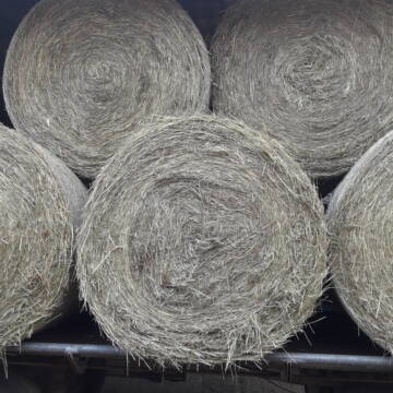
Heulage in Top-Bioqualität
Bothel
LB Sarah Lühring
@Bonito
Heulage
Rundballen
Regenfrei
Wird verladen
1 weitere...
B+
Deprecated: Creation of dynamic property Zend_View_Helper_Ads::$adLink is deprecated in /var/www/stall-frei/htdocs/staging.stall-frei.de/library/Psf/View/Helper/Ads.php on line 108

Futtersack HeuToy, Fressbremse in pink
Mechtersen
STALL-FREIde Marketing
@STALL-FREI-Marketing
Stundenlange Beschäftigung die
Koliken vorbeugt, geringe Staubinhalation mit
steuerbarer Futterentnahme
Leider kein Vorschaubild
Leider kein Vorschaubild
Heu - HD Ballen aus Juni 2025
Wunstorf
Heike-Wichmann-Sasse
@Heike-Wichmann-Sasse
Heu
Empfänger lädt ab
Kleinballen/HD-Ballen
Regenfrei
2 weitere...
B+

Heu in Quaderballen zu verkaufen
Bergen
Bianca Hinrichs-Schröder
@BHS1976
Futter
Empfänger lädt ab
Kleinballen/HD-Ballen
Bio
Regenfrei
2 weitere...
B+

Heu, Heulage, ökologisch, artenreich top Qualitä...
Hamburg
Frederic Wübbe
@Stall_Am_Burgberg
Heu
Lieferant entlädt
Rundballen
Bio
3 weitere...
B+

Persönlichkeitsentwicklung mit Pferden
Bad Salzuflen
Katja Dors
@Pferdezeiten
Begleite andere auf ihrem Entwicklungsweg und entdecke die transformative Kraft der pferdegestützten Persönlichkeitsentwicklung !
neu
R

Heu HD-Ballen 2. Schnitt extensiv Heugräser
Drochtersen
M-Kluth
@M-Kluth
Heu
Empfänger lädt ab
Kleinballen/HD-Ballen
Regenfrei
3 weitere...
B+


Premium Holzpellets als EINSTREU für die Pferdeb...
Spenge
Kenny Puhl
@Puhl-Pellets
Einstreu
Lieferant entlädt
Pellets
Wird verladen
2 weitere...
P+

Rundballen Stroh
Elze-Esbeck
Hof Bartels
@Bartels
Stroh
Lieferant entlädt
Rundballen
Regenfrei
3 weitere...
B+
Heu Rundballen zu verkaufen
Peine
Hof-Hoppenworth
@Hof-Hoppenworth
Heu
Empfänger lädt ab
Rundballen
Regenfrei
3 weitere...
B+

Heu und Stroh zu verkaufen
21527 Kollow
Hof -Linautal
@Hof-Linautal
Heu
Lieferant entlädt
Rundballen
Regenfrei
3 weitere...
aktuell
B+
Deprecated: Creation of dynamic property Zend_View::$pageCount is deprecated in /var/www/stall-frei/htdocs/staging.stall-frei.de/library/vendor/shardj/zf1-future/library/Zend/View/Abstract.php on line 308
Deprecated: Creation of dynamic property Zend_View::$itemCountPerPage is deprecated in /var/www/stall-frei/htdocs/staging.stall-frei.de/library/vendor/shardj/zf1-future/library/Zend/View/Abstract.php on line 308
Deprecated: Creation of dynamic property Zend_View::$first is deprecated in /var/www/stall-frei/htdocs/staging.stall-frei.de/library/vendor/shardj/zf1-future/library/Zend/View/Abstract.php on line 308
Deprecated: Creation of dynamic property Zend_View::$current is deprecated in /var/www/stall-frei/htdocs/staging.stall-frei.de/library/vendor/shardj/zf1-future/library/Zend/View/Abstract.php on line 308
Deprecated: Creation of dynamic property Zend_View::$last is deprecated in /var/www/stall-frei/htdocs/staging.stall-frei.de/library/vendor/shardj/zf1-future/library/Zend/View/Abstract.php on line 308
Deprecated: Creation of dynamic property Zend_View::$next is deprecated in /var/www/stall-frei/htdocs/staging.stall-frei.de/library/vendor/shardj/zf1-future/library/Zend/View/Abstract.php on line 308
Deprecated: Creation of dynamic property Zend_View::$pagesInRange is deprecated in /var/www/stall-frei/htdocs/staging.stall-frei.de/library/vendor/shardj/zf1-future/library/Zend/View/Abstract.php on line 308
Deprecated: Creation of dynamic property Zend_View::$firstPageInRange is deprecated in /var/www/stall-frei/htdocs/staging.stall-frei.de/library/vendor/shardj/zf1-future/library/Zend/View/Abstract.php on line 308
Deprecated: Creation of dynamic property Zend_View::$lastPageInRange is deprecated in /var/www/stall-frei/htdocs/staging.stall-frei.de/library/vendor/shardj/zf1-future/library/Zend/View/Abstract.php on line 308
Deprecated: Creation of dynamic property Zend_View::$currentItemCount is deprecated in /var/www/stall-frei/htdocs/staging.stall-frei.de/library/vendor/shardj/zf1-future/library/Zend/View/Abstract.php on line 308
Deprecated: Creation of dynamic property Zend_View::$totalItemCount is deprecated in /var/www/stall-frei/htdocs/staging.stall-frei.de/library/vendor/shardj/zf1-future/library/Zend/View/Abstract.php on line 308
Deprecated: Creation of dynamic property Zend_View::$firstItemNumber is deprecated in /var/www/stall-frei/htdocs/staging.stall-frei.de/library/vendor/shardj/zf1-future/library/Zend/View/Abstract.php on line 308
Deprecated: Creation of dynamic property Zend_View::$lastItemNumber is deprecated in /var/www/stall-frei/htdocs/staging.stall-frei.de/library/vendor/shardj/zf1-future/library/Zend/View/Abstract.php on line 308
Deprecated: Creation of dynamic property Zend_View::$router is deprecated in /var/www/stall-frei/htdocs/staging.stall-frei.de/library/vendor/shardj/zf1-future/library/Zend/View/Abstract.php on line 308
Deprecated: Creation of dynamic property Zend_View::$urlParams is deprecated in /var/www/stall-frei/htdocs/staging.stall-frei.de/library/vendor/shardj/zf1-future/library/Zend/View/Abstract.php on line 308
Deprecated: Creation of dynamic property Zend_View::$showAds is deprecated in /var/www/stall-frei/htdocs/staging.stall-frei.de/library/vendor/shardj/zf1-future/library/Zend/View/Abstract.php on line 308
Deprecated: Creation of dynamic property Zend_View::$objectIds is deprecated in /var/www/stall-frei/htdocs/staging.stall-frei.de/library/vendor/shardj/zf1-future/library/Zend/View/Abstract.php on line 308
Deprecated: Creation of dynamic property Zend_View::$showNavbar is deprecated in /var/www/stall-frei/htdocs/staging.stall-frei.de/library/vendor/shardj/zf1-future/library/Zend/View/Abstract.php on line 308
Deprecated: Creation of dynamic property Zend_View::$showBreadcrumb is deprecated in /var/www/stall-frei/htdocs/staging.stall-frei.de/library/vendor/shardj/zf1-future/library/Zend/View/Abstract.php on line 308
Deprecated: Creation of dynamic property Zend_View::$showFooter is deprecated in /var/www/stall-frei/htdocs/staging.stall-frei.de/library/vendor/shardj/zf1-future/library/Zend/View/Abstract.php on line 308
Deprecated: Creation of dynamic property Zend_View::$showInternalAds is deprecated in /var/www/stall-frei/htdocs/staging.stall-frei.de/library/vendor/shardj/zf1-future/library/Zend/View/Abstract.php on line 308
Deprecated: Creation of dynamic property Zend_View::$blNoContent is deprecated in /var/www/stall-frei/htdocs/staging.stall-frei.de/library/vendor/shardj/zf1-future/library/Zend/View/Abstract.php on line 308
Deprecated: Creation of dynamic property Zend_View::$sMetaDesc is deprecated in /var/www/stall-frei/htdocs/staging.stall-frei.de/library/vendor/shardj/zf1-future/library/Zend/View/Abstract.php on line 308
Deprecated: Creation of dynamic property Zend_View::$useGmaps is deprecated in /var/www/stall-frei/htdocs/staging.stall-frei.de/library/vendor/shardj/zf1-future/library/Zend/View/Abstract.php on line 308
Deprecated: Creation of dynamic property Zend_View::$touches is deprecated in /var/www/stall-frei/htdocs/staging.stall-frei.de/library/vendor/shardj/zf1-future/library/Zend/View/Abstract.php on line 308
Deprecated: Creation of dynamic property Zend_View::$oProject is deprecated in /var/www/stall-frei/htdocs/staging.stall-frei.de/library/vendor/shardj/zf1-future/library/Zend/View/Abstract.php on line 308
Deprecated: Creation of dynamic property Zend_View::$pageHeadline is deprecated in /var/www/stall-frei/htdocs/staging.stall-frei.de/library/vendor/shardj/zf1-future/library/Zend/View/Abstract.php on line 308
Deprecated: Creation of dynamic property Zend_View::$disableLocationField is deprecated in /var/www/stall-frei/htdocs/staging.stall-frei.de/library/vendor/shardj/zf1-future/library/Zend/View/Abstract.php on line 308
Deprecated: Creation of dynamic property Zend_View::$isSearch is deprecated in /var/www/stall-frei/htdocs/staging.stall-frei.de/library/vendor/shardj/zf1-future/library/Zend/View/Abstract.php on line 308
Deprecated: Creation of dynamic property Zend_View::$pageTitle is deprecated in /var/www/stall-frei/htdocs/staging.stall-frei.de/library/vendor/shardj/zf1-future/library/Zend/View/Abstract.php on line 308
Deprecated: Creation of dynamic property Psf_Form_Element_Text::$class is deprecated in /var/www/stall-frei/htdocs/staging.stall-frei.de/library/vendor/shardj/zf1-future/library/Zend/Form/Element.php on line 874
Deprecated: Creation of dynamic property Psf_Form_Element_Text::$size is deprecated in /var/www/stall-frei/htdocs/staging.stall-frei.de/library/vendor/shardj/zf1-future/library/Zend/Form/Element.php on line 874
Deprecated: Creation of dynamic property Psf_Form_Element_Text::$placeholder is deprecated in /var/www/stall-frei/htdocs/staging.stall-frei.de/library/vendor/shardj/zf1-future/library/Zend/Form/Element.php on line 874
Deprecated: Creation of dynamic property Psf_Form_Element_Hidden::$class is deprecated in /var/www/stall-frei/htdocs/staging.stall-frei.de/library/vendor/shardj/zf1-future/library/Zend/Form/Element.php on line 874
Deprecated: Creation of dynamic property Psf_Form_Element_Hidden::$class is deprecated in /var/www/stall-frei/htdocs/staging.stall-frei.de/library/vendor/shardj/zf1-future/library/Zend/Form/Element.php on line 874
Deprecated: Creation of dynamic property Psf_Form_Element_Hidden::$class is deprecated in /var/www/stall-frei/htdocs/staging.stall-frei.de/library/vendor/shardj/zf1-future/library/Zend/Form/Element.php on line 874
Deprecated: Creation of dynamic property Psf_Form_Element_Hidden::$class is deprecated in /var/www/stall-frei/htdocs/staging.stall-frei.de/library/vendor/shardj/zf1-future/library/Zend/Form/Element.php on line 874
Deprecated: Creation of dynamic property Psf_Form_Element_Select::$class is deprecated in /var/www/stall-frei/htdocs/staging.stall-frei.de/library/vendor/shardj/zf1-future/library/Zend/Form/Element.php on line 874
Deprecated: Creation of dynamic property Psf_Form_Element_Select::$class is deprecated in /var/www/stall-frei/htdocs/staging.stall-frei.de/library/vendor/shardj/zf1-future/library/Zend/Form/Element.php on line 874
Deprecated: Creation of dynamic property Psf_Form_Element_Select::$class is deprecated in /var/www/stall-frei/htdocs/staging.stall-frei.de/library/vendor/shardj/zf1-future/library/Zend/Form/Element.php on line 874
Deprecated: Creation of dynamic property Psf_Form_Element_Select::$class is deprecated in /var/www/stall-frei/htdocs/staging.stall-frei.de/library/vendor/shardj/zf1-future/library/Zend/Form/Element.php on line 874
Deprecated: Creation of dynamic property Zend_View::$sort is deprecated in /var/www/stall-frei/htdocs/staging.stall-frei.de/library/vendor/shardj/zf1-future/library/Zend/View/Abstract.php on line 308
Deprecated: Creation of dynamic property Zend_View::$searchLocation is deprecated in /var/www/stall-frei/htdocs/staging.stall-frei.de/library/vendor/shardj/zf1-future/library/Zend/View/Abstract.php on line 308
Deprecated: Creation of dynamic property Zend_View::$locationHint is deprecated in /var/www/stall-frei/htdocs/staging.stall-frei.de/library/vendor/shardj/zf1-future/library/Zend/View/Abstract.php on line 308
Psf_GeoCoder_Abstract::getLocation: Blender Get Location CachedOrLive
Psf_GeoCoder_Abstract::getCachedOrLive: Blender
Psf_GeoCoder_OpenCageData::makeApiRequest: response:
Array
(
[documentation] => https://opencagedata.com/api
[licenses] => Array
(
[0] => Array
(
[name] => see attribution guide
[url] => https://opencagedata.com/credits
)
)
[results] => Array
(
[0] => Array
(
[bounds] => Array
(
[northeast] => Array
(
[lat] => 52.9734728
[lng] => 9.1888954
)
[southwest] => Array
(
[lat] => 52.8932978
[lng] => 9.0729518
)
)
[components] => Array
(
[ISO_3166-1_alpha-2] => DE
[ISO_3166-1_alpha-3] => DEU
[ISO_3166-2] => Array
(
[0] => DE-NI
)
[_category] => place
[_normalized_city] => Samtgemeinde Thedinghausen
[_type] => village
[continent] => Europe
[country] => Deutschland
[country_code] => de
[county] => Landkreis Verden
[political_union] => European Union
[postcode] => 27337
[state] => Niedersachsen
[state_code] => NI
[town] => Samtgemeinde Thedinghausen
[village] => Blender
)
[confidence] => 7
[formatted] => 27337 Blender, Deutschland
[geometry] => Array
(
[lat] => 52.9260431
[lng] => 9.1349312
)
)
[1] => Array
(
[bounds] => Array
(
[northeast] => Array
(
[lat] => 47.7293544
[lng] => 10.2252197
)
[southwest] => Array
(
[lat] => 47.7292544
[lng] => 10.2251197
)
)
[components] => Array
(
[ISO_3166-1_alpha-2] => DE
[ISO_3166-1_alpha-3] => DEU
[ISO_3166-2] => Array
(
[0] => DE-BY
)
[_category] => natural/water
[_normalized_city] => Wiggensbach
[_type] => peak
[continent] => Europe
[country] => Deutschland
[country_code] => de
[county] => Landkreis Oberallgäu
[peak] => Blender
[political_union] => European Union
[postcode] => 87487
[state] => Bayern
[state_code] => BY
[village] => Wiggensbach
)
[confidence] => 9
[formatted] => Blender, 87487 Wiggensbach, Deutschland
[geometry] => Array
(
[lat] => 47.7293044
[lng] => 10.2251697
)
)
[2] => Array
(
[components] => Array
(
[ISO_3166-1_alpha-2] => FR
[ISO_3166-1_alpha-3] => FRA
[ISO_3166-2] => Array
(
[0] => FR-IDF
[1] => FR-92
)
[_category] => road
[_normalized_city] => Levallois-Perret
[_type] => road
[city] => Levallois-Perret
[continent] => Europe
[country] => France
[country_code] => fr
[county] => Hauts-de-Seine
[local_authority] => Métropole du Grand Paris
[political_union] => European Union
[postcode] => 92300
[road] => Rue Charles Deutschmann
[state] => Île-de-France
[state_code] => IDF
)
[confidence] => 3
[formatted] => Rue Charles Deutschmann, 92300 Levallois-Perret, France
[geometry] => Array
(
[lat] => 48.900049
[lng] => 2.2842
)
)
[3] => Array
(
[components] => Array
(
[ISO_3166-1_alpha-2] => FR
[ISO_3166-1_alpha-3] => FRA
[ISO_3166-2] => Array
(
[0] => FR-ARA
[1] => FR-03
)
[_category] => road
[_normalized_city] => Langy
[_type] => road
[city] => Langy
[continent] => Europe
[country] => France
[country_code] => fr
[county] => Allier
[local_authority] => Communauté de communes Entr'Allier Besbre et Loire
[political_union] => European Union
[postcode] => 03150
[road] => Route de Blenieres
[state] => Auvergne-Rhône-Alpes
[state_code] => ARA
)
[confidence] => 2
[formatted] => Route de Blenieres, 03150 Langy, France
[geometry] => Array
(
[lat] => 46.267838
[lng] => 3.450379
)
)
[4] => Array
(
[components] => Array
(
[ISO_3166-1_alpha-2] => FR
[ISO_3166-1_alpha-3] => FRA
[ISO_3166-2] => Array
(
[0] => FR-ARA
[1] => FR-69
)
[_category] => road
[_normalized_city] => Saint-Martin-en-Haut
[_type] => road
[city] => Saint-Martin-en-Haut
[continent] => Europe
[country] => France
[country_code] => fr
[county] => Rhône
[local_authority] => Communauté de communes des Monts du Lyonnais
[political_union] => European Union
[postcode] => 69850
[road] => chemin de la blénière
[state] => Auvergne-Rhône-Alpes
[state_code] => ARA
)
[confidence] => 2
[formatted] => chemin de la blénière, 69850 Saint-Martin-en-Haut, France
[geometry] => Array
(
[lat] => 45.665287
[lng] => 4.581185
)
)
[5] => Array
(
[components] => Array
(
[ISO_3166-1_alpha-2] => FR
[ISO_3166-1_alpha-3] => FRA
[ISO_3166-2] => Array
(
[0] => FR-ARA
[1] => FR-69
)
[_category] => road
[_normalized_city] => Chambost-Longessaigne
[_type] => road
[city] => Chambost-Longessaigne
[continent] => Europe
[country] => France
[country_code] => fr
[county] => Rhône
[local_authority] => Communauté de communes des Monts du Lyonnais
[political_union] => European Union
[postcode] => 69770
[road] => Chemin de la Bleniere
[state] => Auvergne-Rhône-Alpes
[state_code] => ARA
)
[confidence] => 2
[formatted] => Chemin de la Bleniere, 69770 Chambost-Longessaigne, France
[geometry] => Array
(
[lat] => 45.781002
[lng] => 4.388549
)
)
[6] => Array
(
[components] => Array
(
[ISO_3166-1_alpha-2] => FR
[ISO_3166-1_alpha-3] => FRA
[ISO_3166-2] => Array
(
[0] => FR-ARA
[1] => FR-03
)
[_category] => road
[_normalized_city] => Bransat
[_type] => road
[city] => Bransat
[continent] => Europe
[country] => France
[country_code] => fr
[county] => Allier
[local_authority] => Communauté de communes Saint-Pourçain Sioule Limagne
[political_union] => European Union
[postcode] => 03500
[road] => Chemin de la Blénière
[state] => Auvergne-Rhône-Alpes
[state_code] => ARA
)
[confidence] => 2
[formatted] => Chemin de la Blénière, 03500 Bransat, France
[geometry] => Array
(
[lat] => 46.350896
[lng] => 3.215122
)
)
[7] => Array
(
[components] => Array
(
[ISO_3166-1_alpha-2] => FR
[ISO_3166-1_alpha-3] => FRA
[ISO_3166-2] => Array
(
[0] => FR-ARA
[1] => FR-03
)
[_category] => road
[_normalized_city] => Lapalisse
[_type] => road
[city] => Lapalisse
[continent] => Europe
[country] => France
[country_code] => fr
[county] => Allier
[local_authority] => Communauté de communes du Pays de Lapalisse
[political_union] => European Union
[postcode] => 03120
[road] => Chemin de Bleniere
[state] => Auvergne-Rhône-Alpes
[state_code] => ARA
)
[confidence] => 2
[formatted] => Chemin de Bleniere, 03120 Lapalisse, France
[geometry] => Array
(
[lat] => 46.260913
[lng] => 3.632486
)
)
[8] => Array
(
[components] => Array
(
[ISO_3166-1_alpha-2] => FR
[ISO_3166-1_alpha-3] => FRA
[ISO_3166-2] => Array
(
[0] => FR-PDL
[1] => FR-85
)
[_category] => road
[_normalized_city] => La Boissière-des-Landes
[_type] => road
[city] => La Boissière-des-Landes
[continent] => Europe
[country] => France
[country_code] => fr
[county] => Vendée
[local_authority] => Vendée-Grand-Littoral
[political_union] => European Union
[postcode] => 85430
[road] => la bleniere
[state] => Pays de la Loire
[state_code] => PDL
)
[confidence] => 2
[formatted] => la bleniere, 85430 La Boissière-des-Landes, France
[geometry] => Array
(
[lat] => 46.577111
[lng] => -1.455048
)
)
[9] => Array
(
[components] => Array
(
[ISO_3166-1_alpha-2] => FR
[ISO_3166-1_alpha-3] => FRA
[ISO_3166-2] => Array
(
[0] => FR-ARA
[1] => FR-38
)
[_category] => road
[_normalized_city] => Reventin-Vaugris
[_type] => road
[city] => Reventin-Vaugris
[continent] => Europe
[country] => France
[country_code] => fr
[county] => Isère
[local_authority] => Vienne Condrieu Agglomération
[political_union] => European Union
[postcode] => 38121
[road] => Chemin des Blénières
[state] => Auvergne-Rhône-Alpes
[state_code] => ARA
)
[confidence] => 2
[formatted] => Chemin des Blénières, 38121 Reventin-Vaugris, France
[geometry] => Array
(
[lat] => 45.481115
[lng] => 4.868818
)
)
)
[status] => Array
(
[code] => 200
[message] => OK
)
[stay_informed] => Array
(
[blog] => https://blog.opencagedata.com
[mastodon] => https://en.osm.town/@opencage
)
[thanks] => For using an OpenCage API
[timestamp] => Array
(
[created_http] => Sun, 08 Feb 2026 13:32:25 GMT
[created_unix] => 1770557545
)
[total_results] => 10
)
Psf_GeoCoder_Abstract::convertLocationResult
{"documentation":"https:\/\/opencagedata.com\/api","licenses":[{"name":"see attribution guide","url":"https:\/\/opencagedata.com\/credits"}],"results":[{"bounds":{"northeast":{"lat":52.9734728,"lng":9.1888954},"southwest":{"lat":52.8932978,"lng":9.0729518}},"components":{"ISO_3166-1_alpha-2":"DE","ISO_3166-1_alpha-3":"DEU","ISO_3166-2":["DE-NI"],"_category":"place","_normalized_city":"Samtgemeinde Thedinghausen","_type":"village","continent":"Europe","country":"Deutschland","country_code":"de","county":"Landkreis Verden","political_union":"European Union","postcode":"27337","state":"Niedersachsen","state_code":"NI","town":"Samtgemeinde Thedinghausen","village":"Blender"},"confidence":7,"formatted":"27337 Blender, Deutschland","geometry":{"lat":52.9260431,"lng":9.1349312}},{"bounds":{"northeast":{"lat":47.7293544,"lng":10.2252197},"southwest":{"lat":47.7292544,"lng":10.2251197}},"components":{"ISO_3166-1_alpha-2":"DE","ISO_3166-1_alpha-3":"DEU","ISO_3166-2":["DE-BY"],"_category":"natural\/water","_normalized_city":"Wiggensbach","_type":"peak","continent":"Europe","country":"Deutschland","country_code":"de","county":"Landkreis Oberallg\u00e4u","peak":"Blender","political_union":"European Union","postcode":"87487","state":"Bayern","state_code":"BY","village":"Wiggensbach"},"confidence":9,"formatted":"Blender, 87487 Wiggensbach, Deutschland","geometry":{"lat":47.7293044,"lng":10.2251697}},{"components":{"ISO_3166-1_alpha-2":"FR","ISO_3166-1_alpha-3":"FRA","ISO_3166-2":["FR-IDF","FR-92"],"_category":"road","_normalized_city":"Levallois-Perret","_type":"road","city":"Levallois-Perret","continent":"Europe","country":"France","country_code":"fr","county":"Hauts-de-Seine","local_authority":"M\u00e9tropole du Grand Paris","political_union":"European Union","postcode":"92300","road":"Rue Charles Deutschmann","state":"\u00cele-de-France","state_code":"IDF"},"confidence":3,"formatted":"Rue Charles Deutschmann, 92300 Levallois-Perret, France","geometry":{"lat":48.900049,"lng":2.2842}},{"components":{"ISO_3166-1_alpha-2":"FR","ISO_3166-1_alpha-3":"FRA","ISO_3166-2":["FR-ARA","FR-03"],"_category":"road","_normalized_city":"Langy","_type":"road","city":"Langy","continent":"Europe","country":"France","country_code":"fr","county":"Allier","local_authority":"Communaut\u00e9 de communes Entr'Allier Besbre et Loire","political_union":"European Union","postcode":"03150","road":"Route de Blenieres","state":"Auvergne-Rh\u00f4ne-Alpes","state_code":"ARA"},"confidence":2,"formatted":"Route de Blenieres, 03150 Langy, France","geometry":{"lat":46.267838,"lng":3.450379}},{"components":{"ISO_3166-1_alpha-2":"FR","ISO_3166-1_alpha-3":"FRA","ISO_3166-2":["FR-ARA","FR-69"],"_category":"road","_normalized_city":"Saint-Martin-en-Haut","_type":"road","city":"Saint-Martin-en-Haut","continent":"Europe","country":"France","country_code":"fr","county":"Rh\u00f4ne","local_authority":"Communaut\u00e9 de communes des Monts du Lyonnais","political_union":"European Union","postcode":"69850","road":"chemin de la bl\u00e9ni\u00e8re","state":"Auvergne-Rh\u00f4ne-Alpes","state_code":"ARA"},"confidence":2,"formatted":"chemin de la bl\u00e9ni\u00e8re, 69850 Saint-Martin-en-Haut, France","geometry":{"lat":45.665287,"lng":4.581185}},{"components":{"ISO_3166-1_alpha-2":"FR","ISO_3166-1_alpha-3":"FRA","ISO_3166-2":["FR-ARA","FR-69"],"_category":"road","_normalized_city":"Chambost-Longessaigne","_type":"road","city":"Chambost-Longessaigne","continent":"Europe","country":"France","country_code":"fr","county":"Rh\u00f4ne","local_authority":"Communaut\u00e9 de communes des Monts du Lyonnais","political_union":"European Union","postcode":"69770","road":"Chemin de la Bleniere","state":"Auvergne-Rh\u00f4ne-Alpes","state_code":"ARA"},"confidence":2,"formatted":"Chemin de la Bleniere, 69770 Chambost-Longessaigne, France","geometry":{"lat":45.781002,"lng":4.388549}},{"components":{"ISO_3166-1_alpha-2":"FR","ISO_3166-1_alpha-3":"FRA","ISO_3166-2":["FR-ARA","FR-03"],"_category":"road","_normalized_city":"Bransat","_type":"road","city":"Bransat","continent":"Europe","country":"France","country_code":"fr","county":"Allier","local_authority":"Communaut\u00e9 de communes Saint-Pour\u00e7ain Sioule Limagne","political_union":"European Union","postcode":"03500","road":"Chemin de la Bl\u00e9ni\u00e8re","state":"Auvergne-Rh\u00f4ne-Alpes","state_code":"ARA"},"confidence":2,"formatted":"Chemin de la Bl\u00e9ni\u00e8re, 03500 Bransat, France","geometry":{"lat":46.350896,"lng":3.215122}},{"components":{"ISO_3166-1_alpha-2":"FR","ISO_3166-1_alpha-3":"FRA","ISO_3166-2":["FR-ARA","FR-03"],"_category":"road","_normalized_city":"Lapalisse","_type":"road","city":"Lapalisse","continent":"Europe","country":"France","country_code":"fr","county":"Allier","local_authority":"Communaut\u00e9 de communes du Pays de Lapalisse","political_union":"European Union","postcode":"03120","road":"Chemin de Bleniere","state":"Auvergne-Rh\u00f4ne-Alpes","state_code":"ARA"},"confidence":2,"formatted":"Chemin de Bleniere, 03120 Lapalisse, France","geometry":{"lat":46.260913,"lng":3.632486}},{"components":{"ISO_3166-1_alpha-2":"FR","ISO_3166-1_alpha-3":"FRA","ISO_3166-2":["FR-PDL","FR-85"],"_category":"road","_normalized_city":"La Boissi\u00e8re-des-Landes","_type":"road","city":"La Boissi\u00e8re-des-Landes","continent":"Europe","country":"France","country_code":"fr","county":"Vend\u00e9e","local_authority":"Vend\u00e9e-Grand-Littoral","political_union":"European Union","postcode":"85430","road":"la bleniere","state":"Pays de la Loire","state_code":"PDL"},"confidence":2,"formatted":"la bleniere, 85430 La Boissi\u00e8re-des-Landes, France","geometry":{"lat":46.577111,"lng":-1.455048}},{"components":{"ISO_3166-1_alpha-2":"FR","ISO_3166-1_alpha-3":"FRA","ISO_3166-2":["FR-ARA","FR-38"],"_category":"road","_normalized_city":"Reventin-Vaugris","_type":"road","city":"Reventin-Vaugris","continent":"Europe","country":"France","country_code":"fr","county":"Is\u00e8re","local_authority":"Vienne Condrieu Agglom\u00e9ration","political_union":"European Union","postcode":"38121","road":"Chemin des Bl\u00e9ni\u00e8res","state":"Auvergne-Rh\u00f4ne-Alpes","state_code":"ARA"},"confidence":2,"formatted":"Chemin des Bl\u00e9ni\u00e8res, 38121 Reventin-Vaugris, France","geometry":{"lat":45.481115,"lng":4.868818}}],"status":{"code":200,"message":"OK"},"stay_informed":{"blog":"https:\/\/blog.opencagedata.com","mastodon":"https:\/\/en.osm.town\/@opencage"},"thanks":"For using an OpenCage API","timestamp":{"created_http":"Sun, 08 Feb 2026 13:32:25 GMT","created_unix":1770557545},"total_results":10}Array
(
[0] => stdClass Object
(
[bounds] => stdClass Object
(
[northeast] => stdClass Object
(
[lat] => 52.9734728
[lng] => 9.1888954
)
[southwest] => stdClass Object
(
[lat] => 52.8932978
[lng] => 9.0729518
)
)
[components] => stdClass Object
(
[ISO_3166-1_alpha-2] => DE
[ISO_3166-1_alpha-3] => DEU
[ISO_3166-2] => Array
(
[0] => DE-NI
)
[_category] => place
[_normalized_city] => Samtgemeinde Thedinghausen
[_type] => village
[continent] => Europe
[country] => Deutschland
[country_code] => de
[county] => Landkreis Verden
[political_union] => European Union
[postcode] => 27337
[state] => Niedersachsen
[state_code] => NI
[town] => Samtgemeinde Thedinghausen
[village] => Blender
)
[confidence] => 7
[formatted] => 27337 Blender, Deutschland
[geometry] => stdClass Object
(
[lat] => 52.9260431
[lng] => 9.1349312
)
)
[1] => stdClass Object
(
[bounds] => stdClass Object
(
[northeast] => stdClass Object
(
[lat] => 47.7293544
[lng] => 10.2252197
)
[southwest] => stdClass Object
(
[lat] => 47.7292544
[lng] => 10.2251197
)
)
[components] => stdClass Object
(
[ISO_3166-1_alpha-2] => DE
[ISO_3166-1_alpha-3] => DEU
[ISO_3166-2] => Array
(
[0] => DE-BY
)
[_category] => natural/water
[_normalized_city] => Wiggensbach
[_type] => peak
[continent] => Europe
[country] => Deutschland
[country_code] => de
[county] => Landkreis Oberallgäu
[peak] => Blender
[political_union] => European Union
[postcode] => 87487
[state] => Bayern
[state_code] => BY
[village] => Wiggensbach
)
[confidence] => 9
[formatted] => Blender, 87487 Wiggensbach, Deutschland
[geometry] => stdClass Object
(
[lat] => 47.7293044
[lng] => 10.2251697
)
)
[2] => stdClass Object
(
[components] => stdClass Object
(
[ISO_3166-1_alpha-2] => FR
[ISO_3166-1_alpha-3] => FRA
[ISO_3166-2] => Array
(
[0] => FR-IDF
[1] => FR-92
)
[_category] => road
[_normalized_city] => Levallois-Perret
[_type] => road
[city] => Levallois-Perret
[continent] => Europe
[country] => France
[country_code] => fr
[county] => Hauts-de-Seine
[local_authority] => Métropole du Grand Paris
[political_union] => European Union
[postcode] => 92300
[road] => Rue Charles Deutschmann
[state] => Île-de-France
[state_code] => IDF
)
[confidence] => 3
[formatted] => Rue Charles Deutschmann, 92300 Levallois-Perret, France
[geometry] => stdClass Object
(
[lat] => 48.900049
[lng] => 2.2842
)
)
[3] => stdClass Object
(
[components] => stdClass Object
(
[ISO_3166-1_alpha-2] => FR
[ISO_3166-1_alpha-3] => FRA
[ISO_3166-2] => Array
(
[0] => FR-ARA
[1] => FR-03
)
[_category] => road
[_normalized_city] => Langy
[_type] => road
[city] => Langy
[continent] => Europe
[country] => France
[country_code] => fr
[county] => Allier
[local_authority] => Communauté de communes Entr'Allier Besbre et Loire
[political_union] => European Union
[postcode] => 03150
[road] => Route de Blenieres
[state] => Auvergne-Rhône-Alpes
[state_code] => ARA
)
[confidence] => 2
[formatted] => Route de Blenieres, 03150 Langy, France
[geometry] => stdClass Object
(
[lat] => 46.267838
[lng] => 3.450379
)
)
[4] => stdClass Object
(
[components] => stdClass Object
(
[ISO_3166-1_alpha-2] => FR
[ISO_3166-1_alpha-3] => FRA
[ISO_3166-2] => Array
(
[0] => FR-ARA
[1] => FR-69
)
[_category] => road
[_normalized_city] => Saint-Martin-en-Haut
[_type] => road
[city] => Saint-Martin-en-Haut
[continent] => Europe
[country] => France
[country_code] => fr
[county] => Rhône
[local_authority] => Communauté de communes des Monts du Lyonnais
[political_union] => European Union
[postcode] => 69850
[road] => chemin de la blénière
[state] => Auvergne-Rhône-Alpes
[state_code] => ARA
)
[confidence] => 2
[formatted] => chemin de la blénière, 69850 Saint-Martin-en-Haut, France
[geometry] => stdClass Object
(
[lat] => 45.665287
[lng] => 4.581185
)
)
[5] => stdClass Object
(
[components] => stdClass Object
(
[ISO_3166-1_alpha-2] => FR
[ISO_3166-1_alpha-3] => FRA
[ISO_3166-2] => Array
(
[0] => FR-ARA
[1] => FR-69
)
[_category] => road
[_normalized_city] => Chambost-Longessaigne
[_type] => road
[city] => Chambost-Longessaigne
[continent] => Europe
[country] => France
[country_code] => fr
[county] => Rhône
[local_authority] => Communauté de communes des Monts du Lyonnais
[political_union] => European Union
[postcode] => 69770
[road] => Chemin de la Bleniere
[state] => Auvergne-Rhône-Alpes
[state_code] => ARA
)
[confidence] => 2
[formatted] => Chemin de la Bleniere, 69770 Chambost-Longessaigne, France
[geometry] => stdClass Object
(
[lat] => 45.781002
[lng] => 4.388549
)
)
[6] => stdClass Object
(
[components] => stdClass Object
(
[ISO_3166-1_alpha-2] => FR
[ISO_3166-1_alpha-3] => FRA
[ISO_3166-2] => Array
(
[0] => FR-ARA
[1] => FR-03
)
[_category] => road
[_normalized_city] => Bransat
[_type] => road
[city] => Bransat
[continent] => Europe
[country] => France
[country_code] => fr
[county] => Allier
[local_authority] => Communauté de communes Saint-Pourçain Sioule Limagne
[political_union] => European Union
[postcode] => 03500
[road] => Chemin de la Blénière
[state] => Auvergne-Rhône-Alpes
[state_code] => ARA
)
[confidence] => 2
[formatted] => Chemin de la Blénière, 03500 Bransat, France
[geometry] => stdClass Object
(
[lat] => 46.350896
[lng] => 3.215122
)
)
[7] => stdClass Object
(
[components] => stdClass Object
(
[ISO_3166-1_alpha-2] => FR
[ISO_3166-1_alpha-3] => FRA
[ISO_3166-2] => Array
(
[0] => FR-ARA
[1] => FR-03
)
[_category] => road
[_normalized_city] => Lapalisse
[_type] => road
[city] => Lapalisse
[continent] => Europe
[country] => France
[country_code] => fr
[county] => Allier
[local_authority] => Communauté de communes du Pays de Lapalisse
[political_union] => European Union
[postcode] => 03120
[road] => Chemin de Bleniere
[state] => Auvergne-Rhône-Alpes
[state_code] => ARA
)
[confidence] => 2
[formatted] => Chemin de Bleniere, 03120 Lapalisse, France
[geometry] => stdClass Object
(
[lat] => 46.260913
[lng] => 3.632486
)
)
[8] => stdClass Object
(
[components] => stdClass Object
(
[ISO_3166-1_alpha-2] => FR
[ISO_3166-1_alpha-3] => FRA
[ISO_3166-2] => Array
(
[0] => FR-PDL
[1] => FR-85
)
[_category] => road
[_normalized_city] => La Boissière-des-Landes
[_type] => road
[city] => La Boissière-des-Landes
[continent] => Europe
[country] => France
[country_code] => fr
[county] => Vendée
[local_authority] => Vendée-Grand-Littoral
[political_union] => European Union
[postcode] => 85430
[road] => la bleniere
[state] => Pays de la Loire
[state_code] => PDL
)
[confidence] => 2
[formatted] => la bleniere, 85430 La Boissière-des-Landes, France
[geometry] => stdClass Object
(
[lat] => 46.577111
[lng] => -1.455048
)
)
[9] => stdClass Object
(
[components] => stdClass Object
(
[ISO_3166-1_alpha-2] => FR
[ISO_3166-1_alpha-3] => FRA
[ISO_3166-2] => Array
(
[0] => FR-ARA
[1] => FR-38
)
[_category] => road
[_normalized_city] => Reventin-Vaugris
[_type] => road
[city] => Reventin-Vaugris
[continent] => Europe
[country] => France
[country_code] => fr
[county] => Isère
[local_authority] => Vienne Condrieu Agglomération
[political_union] => European Union
[postcode] => 38121
[road] => Chemin des Blénières
[state] => Auvergne-Rhône-Alpes
[state_code] => ARA
)
[confidence] => 2
[formatted] => Chemin des Blénières, 38121 Reventin-Vaugris, France
[geometry] => stdClass Object
(
[lat] => 45.481115
[lng] => 4.868818
)
)
)
Psf_GeoCoder_OpenCageData::getKeyMap: 0
stdClass Object
(
    [bounds] => stdClass Object
        (
            [northeast] => stdClass Object
                (
                    [lat] => 52.9734728
                    [lng] => 9.1888954
                )

            [southwest] => stdClass Object
                (
                    [lat] => 52.8932978
                    [lng] => 9.0729518
                )

        )

    [components] => stdClass Object
        (
            [ISO_3166-1_alpha-2] => DE
            [ISO_3166-1_alpha-3] => DEU
            [ISO_3166-2] => Array
                (
                    [0] => DE-NI
                )

            [_category] => place
            [_normalized_city] => Samtgemeinde Thedinghausen
            [_type] => village
            [continent] => Europe
            [country] => Deutschland
            [country_code] => de
            [county] => Landkreis Verden
            [political_union] => European Union
            [postcode] => 27337
            [state] => Niedersachsen
            [state_code] => NI
            [town] => Samtgemeinde Thedinghausen
            [village] => Blender
        )

    [confidence] => 7
    [formatted] => 27337 Blender, Deutschland
    [geometry] => stdClass Object
        (
            [lat] => 52.9260431
            [lng] => 9.1349312
        )

)
Psf_GeoCoder_OpenCageData::getCounty: Verden
Psf_GeoCoder_OpenCageData::addMissingData REFETCH!
Array
(
    [address] => 27337 Blender, Deutschland
    [type] => village
    [street] =>
    [city] => Samtgemeinde Thedinghausen
    [county] => Verden
    [state] => Niedersachsen
    [zip] => 27337
    [country] => Deutschland
    [suburb] =>
    [countrycode] => de
    [latitude] => 52.9260431
    [longitude] => 9.1349312
    [accuracy] => 1
    [confidence] => 7
    [bounds] => stdClass Object
        (
            [northeast] => stdClass Object
                (
                    [lat] => 52.9734728
                    [lng] => 9.1888954
                )

            [southwest] => stdClass Object
                (
                    [lat] => 52.8932978
                    [lng] => 9.0729518
                )

        )

)
reformat!
Array
(
    [address] => 27337 Samtgemeinde Thedinghausen
    [type] => village
    [street] =>
    [city] => Samtgemeinde Thedinghausen
    [county] => Verden
    [state] => Niedersachsen
    [zip] => 27337
    [country] => Deutschland
    [suburb] =>
    [countrycode] => de
    [latitude] => 52.9260431
    [longitude] => 9.1349312
    [accuracy] => 1
    [confidence] => 7
    [bounds] => stdClass Object
        (
            [northeast] => stdClass Object
                (
                    [lat] => 52.9734728
                    [lng] => 9.1888954
                )

            [southwest] => stdClass Object
                (
                    [lat] => 52.8932978
                    [lng] => 9.0729518
                )

        )

    [place] => 27337 Samtgemeinde Thedinghausen, Niedersachsen
    [hash] => 3affdcd6f5fd6877d149c464f4253a75
)
Psf_GeoCoder_OpenCageData::getKeyMap: 1
stdClass Object
(
    [bounds] => stdClass Object
        (
            [northeast] => stdClass Object
                (
                    [lat] => 47.7293544
                    [lng] => 10.2252197
                )

            [southwest] => stdClass Object
                (
                    [lat] => 47.7292544
                    [lng] => 10.2251197
                )

        )

    [components] => stdClass Object
        (
            [ISO_3166-1_alpha-2] => DE
            [ISO_3166-1_alpha-3] => DEU
            [ISO_3166-2] => Array
                (
                    [0] => DE-BY
                )

            [_category] => natural/water
            [_normalized_city] => Wiggensbach
            [_type] => peak
            [continent] => Europe
            [country] => Deutschland
            [country_code] => de
            [county] => Landkreis Oberallgäu
            [peak] => Blender
            [political_union] => European Union
            [postcode] => 87487
            [state] => Bayern
            [state_code] => BY
            [village] => Wiggensbach
        )

    [confidence] => 9
    [formatted] => Blender, 87487 Wiggensbach, Deutschland
    [geometry] => stdClass Object
        (
            [lat] => 47.7293044
            [lng] => 10.2251697
        )

)
Psf_GeoCoder_OpenCageData::getCounty: Oberallgäu
Psf_GeoCoder_OpenCageData::addMissingData REFETCH!
Array
(
    [address] => Blender, 87487 Wiggensbach, Deutschland
    [type] => peak
    [street] =>
    [city] => Wiggensbach
    [county] => Oberallgäu
    [state] => Bayern
    [zip] => 87487
    [country] => Deutschland
    [suburb] =>
    [countrycode] => de
    [latitude] => 47.7293044
    [longitude] => 10.2251697
    [accuracy] => 1
    [confidence] => 9
    [bounds] => stdClass Object
        (
            [northeast] => stdClass Object
                (
                    [lat] => 47.7293544
                    [lng] => 10.2252197
                )

            [southwest] => stdClass Object
                (
                    [lat] => 47.7292544
                    [lng] => 10.2251197
                )

        )

)
reformat!
Array
(
    [address] => Blender, 87487 Wiggensbach, Deutschland
    [type] => peak
    [street] =>
    [city] => Wiggensbach
    [county] => Oberallgäu
    [state] => Bayern
    [zip] => 87487
    [country] => Deutschland
    [suburb] =>
    [countrycode] => de
    [latitude] => 47.7293044
    [longitude] => 10.2251697
    [accuracy] => 1
    [confidence] => 9
    [bounds] => stdClass Object
        (
            [northeast] => stdClass Object
                (
                    [lat] => 47.7293544
                    [lng] => 10.2252197
                )

            [southwest] => stdClass Object
                (
                    [lat] => 47.7292544
                    [lng] => 10.2251197
                )

        )

    [place] => 87487 Wiggensbach, Bayern
    [hash] => eddb72a2440491ed33f4556007c8d644
)
Psf_GeoCoder_OpenCageData::getKeyMap: 2
stdClass Object
(
    [components] => stdClass Object
        (
            [ISO_3166-1_alpha-2] => FR
            [ISO_3166-1_alpha-3] => FRA
            [ISO_3166-2] => Array
                (
                    [0] => FR-IDF
                    [1] => FR-92
                )

            [_category] => road
            [_normalized_city] => Levallois-Perret
            [_type] => road
            [city] => Levallois-Perret
            [continent] => Europe
            [country] => France
            [country_code] => fr
            [county] => Hauts-de-Seine
            [local_authority] => Métropole du Grand Paris
            [political_union] => European Union
            [postcode] => 92300
            [road] => Rue Charles Deutschmann
            [state] => Île-de-France
            [state_code] => IDF
        )

    [confidence] => 3
    [formatted] => Rue Charles Deutschmann, 92300 Levallois-Perret, France
    [geometry] => stdClass Object
        (
            [lat] => 48.900049
            [lng] => 2.2842
        )

)
Psf_GeoCoder_OpenCageData::getCounty: Hauts-de-Seine
Psf_GeoCoder_OpenCageData::addMissingData REFETCH!
Array
(
    [address] => Rue Charles Deutschmann, 92300 Levallois-Perret, France
    [type] => road
    [street] => Rue Charles Deutschmann
    [city] => Levallois-Perret
    [county] => Hauts-de-Seine
    [state] => Île-de-France
    [zip] => 92300
    [country] => France
    [suburb] =>
    [countrycode] => fr
    [latitude] => 48.900049
    [longitude] => 2.2842
    [accuracy] => 1
    [confidence] => 3
    [bounds] =>
)
reformat!
Array
(
    [address] => Rue Charles Deutschmann, 92300 Levallois-Perret, France
    [type] => road
    [street] => Rue Charles Deutschmann
    [city] => Levallois-Perret
    [county] => Hauts-de-Seine
    [state] => Île-de-France
    [zip] => 92300
    [country] => France
    [suburb] =>
    [countrycode] => fr
    [latitude] => 48.900049
    [longitude] => 2.2842
    [accuracy] => 1
    [confidence] => 3
    [bounds] =>
    [place] => Rue Charles Deutschmann, 92300 Levallois-Perret, Île-de-France
    [hash] => b7dc44def3990e8a7eaf18e019eca466
)
Psf_GeoCoder_OpenCageData::getKeyMap: 3
stdClass Object
(
    [components] => stdClass Object
        (
            [ISO_3166-1_alpha-2] => FR
            [ISO_3166-1_alpha-3] => FRA
            [ISO_3166-2] => Array
                (
                    [0] => FR-ARA
                    [1] => FR-03
                )

            [_category] => road
            [_normalized_city] => Langy
            [_type] => road
            [city] => Langy
            [continent] => Europe
            [country] => France
            [country_code] => fr
            [county] => Allier
            [local_authority] => Communauté de communes Entr'Allier Besbre et Loire
            [political_union] => European Union
            [postcode] => 03150
            [road] => Route de Blenieres
            [state] => Auvergne-Rhône-Alpes
            [state_code] => ARA
        )

    [confidence] => 2
    [formatted] => Route de Blenieres, 03150 Langy, France
    [geometry] => stdClass Object
        (
            [lat] => 46.267838
            [lng] => 3.450379
        )

)
Psf_GeoCoder_OpenCageData::getCounty: Allier
Psf_GeoCoder_OpenCageData::addMissingData REFETCH!
Array
(
    [address] => Route de Blenieres, 03150 Langy, France
    [type] => road
    [street] => Route de Blenieres
    [city] => Langy
    [county] => Allier
    [state] => Auvergne-Rhône-Alpes
    [zip] => 03150
    [country] => France
    [suburb] =>
    [countrycode] => fr
    [latitude] => 46.267838
    [longitude] => 3.450379
    [accuracy] => 1
    [confidence] => 2
    [bounds] =>
)
reformat!
Array
(
    [address] => Route de Blenieres, 03150 Langy, France
    [type] => road
    [street] => Route de Blenieres
    [city] => Langy
    [county] => Allier
    [state] => Auvergne-Rhône-Alpes
    [zip] => 03150
    [country] => France
    [suburb] =>
    [countrycode] => fr
    [latitude] => 46.267838
    [longitude] => 3.450379
    [accuracy] => 1
    [confidence] => 2
    [bounds] =>
    [place] => Route de Blenieres, 03150 Langy, Auvergne-Rhône-Alpes
    [hash] => e1a1fba716102ea461f276ddfe7c576e
)
Psf_GeoCoder_OpenCageData::getKeyMap: 4
stdClass Object
(
    [components] => stdClass Object
        (
            [ISO_3166-1_alpha-2] => FR
            [ISO_3166-1_alpha-3] => FRA
            [ISO_3166-2] => Array
                (
                    [0] => FR-ARA
                    [1] => FR-69
                )

            [_category] => road
            [_normalized_city] => Saint-Martin-en-Haut
            [_type] => road
            [city] => Saint-Martin-en-Haut
            [continent] => Europe
            [country] => France
            [country_code] => fr
            [county] => Rhône
            [local_authority] => Communauté de communes des Monts du Lyonnais
            [political_union] => European Union
            [postcode] => 69850
            [road] => chemin de la blénière
            [state] => Auvergne-Rhône-Alpes
            [state_code] => ARA
        )

    [confidence] => 2
    [formatted] => chemin de la blénière, 69850 Saint-Martin-en-Haut, France
    [geometry] => stdClass Object
        (
            [lat] => 45.665287
            [lng] => 4.581185
        )

)
Psf_GeoCoder_OpenCageData::getCounty: Rhône
Psf_GeoCoder_OpenCageData::addMissingData REFETCH!
Array
(
    [address] => chemin de la blénière, 69850 Saint-Martin-en-Haut, France
    [type] => road
    [street] => chemin de la blénière
    [city] => Saint-Martin-en-Haut
    [county] => Rhône
    [state] => Auvergne-Rhône-Alpes
    [zip] => 69850
    [country] => France
    [suburb] =>
    [countrycode] => fr
    [latitude] => 45.665287
    [longitude] => 4.581185
    [accuracy] => 1
    [confidence] => 2
    [bounds] =>
)
reformat!
Array
(
    [address] => chemin de la blénière, 69850 Saint-Martin-en-Haut, France
    [type] => road
    [street] => chemin de la blénière
    [city] => Saint-Martin-en-Haut
    [county] => Rhône
    [state] => Auvergne-Rhône-Alpes
    [zip] => 69850
    [country] => France
    [suburb] =>
    [countrycode] => fr
    [latitude] => 45.665287
    [longitude] => 4.581185
    [accuracy] => 1
    [confidence] => 2
    [bounds] =>
    [place] => chemin de la blénière, 69850 Saint-Martin-en-Haut, Auvergne-Rhône-Alpes
    [hash] => 75b6f51ebb335fdab969e281b1717390
)
Psf_GeoCoder_OpenCageData::getKeyMap: 5
stdClass Object
(
    [components] => stdClass Object
        (
            [ISO_3166-1_alpha-2] => FR
            [ISO_3166-1_alpha-3] => FRA
            [ISO_3166-2] => Array
                (
                    [0] => FR-ARA
                    [1] => FR-69
                )

            [_category] => road
            [_normalized_city] => Chambost-Longessaigne
            [_type] => road
            [city] => Chambost-Longessaigne
            [continent] => Europe
            [country] => France
            [country_code] => fr
            [county] => Rhône
            [local_authority] => Communauté de communes des Monts du Lyonnais
            [political_union] => European Union
            [postcode] => 69770
            [road] => Chemin de la Bleniere
            [state] => Auvergne-Rhône-Alpes
            [state_code] => ARA
        )

    [confidence] => 2
    [formatted] => Chemin de la Bleniere, 69770 Chambost-Longessaigne, France
    [geometry] => stdClass Object
        (
            [lat] => 45.781002
            [lng] => 4.388549
        )

)
Psf_GeoCoder_OpenCageData::getCounty: Rhône
Psf_GeoCoder_OpenCageData::addMissingData REFETCH!
Array
(
    [address] => Chemin de la Bleniere, 69770 Chambost-Longessaigne, France
    [type] => road
    [street] => Chemin de la Bleniere
    [city] => Chambost-Longessaigne
    [county] => Rhône
    [state] => Auvergne-Rhône-Alpes
    [zip] => 69770
    [country] => France
    [suburb] =>
    [countrycode] => fr
    [latitude] => 45.781002
    [longitude] => 4.388549
    [accuracy] => 1
    [confidence] => 2
    [bounds] =>
)
reformat!
Array
(
    [address] => Chemin de la Bleniere, 69770 Chambost-Longessaigne, France
    [type] => road
    [street] => Chemin de la Bleniere
    [city] => Chambost-Longessaigne
    [county] => Rhône
    [state] => Auvergne-Rhône-Alpes
    [zip] => 69770
    [country] => France
    [suburb] =>
    [countrycode] => fr
    [latitude] => 45.781002
    [longitude] => 4.388549
    [accuracy] => 1
    [confidence] => 2
    [bounds] =>
    [place] => Chemin de la Bleniere, 69770 Chambost-Longessaigne, Auvergne-Rhône-Alpes
    [hash] => 635fcc5d2d9caf3e4e93e2293eb0063f
)
Psf_GeoCoder_OpenCageData::getKeyMap: 6
stdClass Object
(
    [components] => stdClass Object
        (
            [ISO_3166-1_alpha-2] => FR
            [ISO_3166-1_alpha-3] => FRA
            [ISO_3166-2] => Array
                (
                    [0] => FR-ARA
                    [1] => FR-03
                )

            [_category] => road
            [_normalized_city] => Bransat
            [_type] => road
            [city] => Bransat
            [continent] => Europe
            [country] => France
            [country_code] => fr
            [county] => Allier
            [local_authority] => Communauté de communes Saint-Pourçain Sioule Limagne
            [political_union] => European Union
            [postcode] => 03500
            [road] => Chemin de la Blénière
            [state] => Auvergne-Rhône-Alpes
            [state_code] => ARA
        )

    [confidence] => 2
    [formatted] => Chemin de la Blénière, 03500 Bransat, France
    [geometry] => stdClass Object
        (
            [lat] => 46.350896
            [lng] => 3.215122
        )

)
Psf_GeoCoder_OpenCageData::getCounty: Allier
Psf_GeoCoder_OpenCageData::addMissingData REFETCH!
Array
(
    [address] => Chemin de la Blénière, 03500 Bransat, France
    [type] => road
    [street] => Chemin de la Blénière
    [city] => Bransat
    [county] => Allier
    [state] => Auvergne-Rhône-Alpes
    [zip] => 03500
    [country] => France
    [suburb] =>
    [countrycode] => fr
    [latitude] => 46.350896
    [longitude] => 3.215122
    [accuracy] => 1
    [confidence] => 2
    [bounds] =>
)
reformat!
Array
(
    [address] => Chemin de la Blénière, 03500 Bransat, France
    [type] => road
    [street] => Chemin de la Blénière
    [city] => Bransat
    [county] => Allier
    [state] => Auvergne-Rhône-Alpes
    [zip] => 03500
    [country] => France
    [suburb] =>
    [countrycode] => fr
    [latitude] => 46.350896
    [longitude] => 3.215122
    [accuracy] => 1
    [confidence] => 2
    [bounds] =>
    [place] => Chemin de la Blénière, 03500 Bransat, Auvergne-Rhône-Alpes
    [hash] => 7827151c8668caad2764c2b7e632d1ef
)
Psf_GeoCoder_OpenCageData::getKeyMap: 7
stdClass Object
(
    [components] => stdClass Object
        (
            [ISO_3166-1_alpha-2] => FR
            [ISO_3166-1_alpha-3] => FRA
            [ISO_3166-2] => Array
                (
                    [0] => FR-ARA
                    [1] => FR-03
                )

            [_category] => road
            [_normalized_city] => Lapalisse
            [_type] => road
            [city] => Lapalisse
            [continent] => Europe
            [country] => France
            [country_code] => fr
            [county] => Allier
            [local_authority] => Communauté de communes du Pays de Lapalisse
            [political_union] => European Union
            [postcode] => 03120
            [road] => Chemin de Bleniere
            [state] => Auvergne-Rhône-Alpes
            [state_code] => ARA
        )

    [confidence] => 2
    [formatted] => Chemin de Bleniere, 03120 Lapalisse, France
    [geometry] => stdClass Object
        (
            [lat] => 46.260913
            [lng] => 3.632486
        )

)
Psf_GeoCoder_OpenCageData::getCounty: Allier
Psf_GeoCoder_OpenCageData::addMissingData REFETCH!
Array
(
    [address] => Chemin de Bleniere, 03120 Lapalisse, France
    [type] => road
    [street] => Chemin de Bleniere
    [city] => Lapalisse
    [county] => Allier
    [state] => Auvergne-Rhône-Alpes
    [zip] => 03120
    [country] => France
    [suburb] =>
    [countrycode] => fr
    [latitude] => 46.260913
    [longitude] => 3.632486
    [accuracy] => 1
    [confidence] => 2
    [bounds] =>
)
reformat!
Array
(
    [address] => Chemin de Bleniere, 03120 Lapalisse, France
    [type] => road
    [street] => Chemin de Bleniere
    [city] => Lapalisse
    [county] => Allier
    [state] => Auvergne-Rhône-Alpes
    [zip] => 03120
    [country] => France
    [suburb] =>
    [countrycode] => fr
    [latitude] => 46.260913
    [longitude] => 3.632486
    [accuracy] => 1
    [confidence] => 2
    [bounds] =>
    [place] => Chemin de Bleniere, 03120 Lapalisse, Auvergne-Rhône-Alpes
    [hash] => bf15cb219f56325146eb09de18b959f5
)
Psf_GeoCoder_OpenCageData::getKeyMap: 8
stdClass Object
(
    [components] => stdClass Object
        (
            [ISO_3166-1_alpha-2] => FR
            [ISO_3166-1_alpha-3] => FRA
            [ISO_3166-2] => Array
                (
                    [0] => FR-PDL
                    [1] => FR-85
                )

            [_category] => road
            [_normalized_city] => La Boissière-des-Landes
            [_type] => road
            [city] => La Boissière-des-Landes
            [continent] => Europe
            [country] => France
            [country_code] => fr
            [county] => Vendée
            [local_authority] => Vendée-Grand-Littoral
            [political_union] => European Union
            [postcode] => 85430
            [road] => la bleniere
            [state] => Pays de la Loire
            [state_code] => PDL
        )

    [confidence] => 2
    [formatted] => la bleniere, 85430 La Boissière-des-Landes, France
    [geometry] => stdClass Object
        (
            [lat] => 46.577111
            [lng] => -1.455048
        )

)
Psf_GeoCoder_OpenCageData::getCounty: Vendée
Psf_GeoCoder_OpenCageData::addMissingData REFETCH!
Array
(
    [address] => la bleniere, 85430 La Boissière-des-Landes, France
    [type] => road
    [street] => la bleniere
    [city] => La Boissière-des-Landes
    [county] => Vendée
    [state] => Pays de la Loire
    [zip] => 85430
    [country] => France
    [suburb] =>
    [countrycode] => fr
    [latitude] => 46.577111
    [longitude] => -1.455048
    [accuracy] => 1
    [confidence] => 2
    [bounds] =>
)
reformat!
Array
(
    [address] => la bleniere, 85430 La Boissière-des-Landes, France
    [type] => road
    [street] => la bleniere
    [city] => La Boissière-des-Landes
    [county] => Vendée
    [state] => Pays de la Loire
    [zip] => 85430
    [country] => France
    [suburb] =>
    [countrycode] => fr
    [latitude] => 46.577111
    [longitude] => -1.455048
    [accuracy] => 1
    [confidence] => 2
    [bounds] =>
    [place] => la bleniere, 85430 La Boissière-des-Landes, Pays de la Loire
    [hash] => a706f3ba233114c0f75d464c01f92dd7
)
Psf_GeoCoder_OpenCageData::getKeyMap: 9
stdClass Object
(
    [components] => stdClass Object
        (
            [ISO_3166-1_alpha-2] => FR
            [ISO_3166-1_alpha-3] => FRA
            [ISO_3166-2] => Array
                (
                    [0] => FR-ARA
                    [1] => FR-38
                )

            [_category] => road
            [_normalized_city] => Reventin-Vaugris
            [_type] => road
            [city] => Reventin-Vaugris
            [continent] => Europe
            [country] => France
            [country_code] => fr
            [county] => Isère
            [local_authority] => Vienne Condrieu Agglomération
            [political_union] => European Union
            [postcode] => 38121
            [road] => Chemin des Blénières
            [state] => Auvergne-Rhône-Alpes
            [state_code] => ARA
        )

    [confidence] => 2
    [formatted] => Chemin des Blénières, 38121 Reventin-Vaugris, France
    [geometry] => stdClass Object
        (
            [lat] => 45.481115
            [lng] => 4.868818
        )

)
Psf_GeoCoder_OpenCageData::getCounty: Isère
Psf_GeoCoder_OpenCageData::addMissingData REFETCH!
Array
(
    [address] => Chemin des Blénières, 38121 Reventin-Vaugris, France
    [type] => road
    [street] => Chemin des Blénières
    [city] => Reventin-Vaugris
    [county] => Isère
    [state] => Auvergne-Rhône-Alpes
    [zip] => 38121
    [country] => France
    [suburb] =>
    [countrycode] => fr
    [latitude] => 45.481115
    [longitude] => 4.868818
    [accuracy] => 1
    [confidence] => 2
    [bounds] =>
)
reformat!
Array
(
    [address] => Chemin des Blénières, 38121 Reventin-Vaugris, France
    [type] => road
    [street] => Chemin des Blénières
    [city] => Reventin-Vaugris
    [county] => Isère
    [state] => Auvergne-Rhône-Alpes
    [zip] => 38121
    [country] => France
    [suburb] =>
    [countrycode] => fr
    [latitude] => 45.481115
    [longitude] => 4.868818
    [accuracy] => 1
    [confidence] => 2
    [bounds] =>
    [place] => Chemin des Blénières, 38121 Reventin-Vaugris, Auvergne-Rhône-Alpes
    [hash] => 5ab85868aebfef99319843298893f397
)
Deprecated: Creation of dynamic property Zend_View::$locationHintStyle is deprecated in /var/www/stall-frei/htdocs/staging.stall-frei.de/library/vendor/shardj/zf1-future/library/Zend/View/Abstract.php on line 308
Deprecated: Creation of dynamic property Zend_View::$adGeoLocation is deprecated in /var/www/stall-frei/htdocs/staging.stall-frei.de/library/vendor/shardj/zf1-future/library/Zend/View/Abstract.php on line 308
Deprecated: Creation of dynamic property Zend_View::$recordCount is deprecated in /var/www/stall-frei/htdocs/staging.stall-frei.de/library/vendor/shardj/zf1-future/library/Zend/View/Abstract.php on line 308
Deprecated: explode(): Passing null to parameter #2 ($string) of type string is deprecated in /var/www/stall-frei/htdocs/staging.stall-frei.de/application/models/SearchAgent.php on line 100
Deprecated: explode(): Passing null to parameter #2 ($string) of type string is deprecated in /var/www/stall-frei/htdocs/staging.stall-frei.de/application/models/SearchAgent.php on line 100
Deprecated: explode(): Passing null to parameter #2 ($string) of type string is deprecated in /var/www/stall-frei/htdocs/staging.stall-frei.de/application/models/SearchAgent.php on line 100
Deprecated: explode(): Passing null to parameter #2 ($string) of type string is deprecated in /var/www/stall-frei/htdocs/staging.stall-frei.de/application/models/SearchAgent.php on line 100
Deprecated: explode(): Passing null to parameter #2 ($string) of type string is deprecated in /var/www/stall-frei/htdocs/staging.stall-frei.de/application/models/SearchAgent.php on line 100
Deprecated: explode(): Passing null to parameter #2 ($string) of type string is deprecated in /var/www/stall-frei/htdocs/staging.stall-frei.de/application/models/SearchAgent.php on line 100
Deprecated: trim(): Passing null to parameter #1 ($string) of type string is deprecated in /var/www/stall-frei/htdocs/staging.stall-frei.de/application/models/Account/Search.php on line 82
Warning: Cannot modify header information - headers already sent by (output started at /var/www/stall-frei/htdocs/staging.stall-frei.de/library/vendor/shardj/zf1-future/library/Zend/View/Abstract.php:308) in /var/www/stall-frei/htdocs/staging.stall-frei.de/application/models/Account/Search.php on line 71
Deprecated: Creation of dynamic property Zend_View::$paginationParams is deprecated in /var/www/stall-frei/htdocs/staging.stall-frei.de/library/vendor/shardj/zf1-future/library/Zend/View/Abstract.php on line 308
Deprecated: Creation of dynamic property Zend_View::$objectPaginator is deprecated in /var/www/stall-frei/htdocs/staging.stall-frei.de/library/vendor/shardj/zf1-future/library/Zend/View/Abstract.php on line 308
Deprecated: Creation of dynamic property Zend_View::$featuredObjects is deprecated in /var/www/stall-frei/htdocs/staging.stall-frei.de/library/vendor/shardj/zf1-future/library/Zend/View/Abstract.php on line 308
Deprecated: Creation of dynamic property Zend_View::$hints is deprecated in /var/www/stall-frei/htdocs/staging.stall-frei.de/library/vendor/shardj/zf1-future/library/Zend/View/Abstract.php on line 308
Deprecated: Creation of dynamic property Zend_View::$attributeHints is deprecated in /var/www/stall-frei/htdocs/staging.stall-frei.de/library/vendor/shardj/zf1-future/library/Zend/View/Abstract.php on line 308
Deprecated: Creation of dynamic property Zend_View::$oSearchForm is deprecated in /var/www/stall-frei/htdocs/staging.stall-frei.de/library/vendor/shardj/zf1-future/library/Zend/View/Abstract.php on line 308