Deprecated: Creation of dynamic property Zend_View::$sMode is deprecated in /var/www/stall-frei/htdocs/staging.stall-frei.de/library/vendor/shardj/zf1-future/library/Zend/View/Abstract.php on line 308
Dienstleistung in Ahneby
Gesucht wird in "Ahneby, Schleswig-Holstein, Deutschland"
488 Einträge
Deprecated: Creation of dynamic property Zend_View::$listObjects is deprecated in /var/www/stall-frei/htdocs/staging.stall-frei.de/library/vendor/shardj/zf1-future/library/Zend/View/Abstract.php on line 308
Deprecated: Creation of dynamic property Zend_View::$listMode is deprecated in /var/www/stall-frei/htdocs/staging.stall-frei.de/library/vendor/shardj/zf1-future/library/Zend/View/Abstract.php on line 308
Deprecated: Creation of dynamic property Zend_View::$renderedObjects is deprecated in /var/www/stall-frei/htdocs/staging.stall-frei.de/library/vendor/shardj/zf1-future/library/Zend/View/Abstract.php on line 308
Deprecated: Creation of dynamic property Zend_View::$index is deprecated in /var/www/stall-frei/htdocs/staging.stall-frei.de/library/vendor/shardj/zf1-future/library/Zend/View/Abstract.php on line 308
Deprecated: Creation of dynamic property Zend_View::$displayMode is deprecated in /var/www/stall-frei/htdocs/staging.stall-frei.de/library/vendor/shardj/zf1-future/library/Zend/View/Abstract.php on line 308
Deprecated: Creation of dynamic property Zend_View::$remarketingIds is deprecated in /var/www/stall-frei/htdocs/staging.stall-frei.de/library/vendor/shardj/zf1-future/library/Zend/View/Abstract.php on line 308
Deprecated: Creation of dynamic property Zend_View::$listItem is deprecated in /var/www/stall-frei/htdocs/staging.stall-frei.de/library/vendor/shardj/zf1-future/library/Zend/View/Abstract.php on line 308
Deprecated: Creation of dynamic property Zend_View::$object is deprecated in /var/www/stall-frei/htdocs/staging.stall-frei.de/library/vendor/shardj/zf1-future/library/Zend/View/Abstract.php on line 308
Deprecated: Creation of dynamic property Zend_View::$attributes is deprecated in /var/www/stall-frei/htdocs/staging.stall-frei.de/library/vendor/shardj/zf1-future/library/Zend/View/Abstract.php on line 308

Pferdeosteopathie & Pferdephysiotherapie
Celle
Helen Voss
@HelenVoss
Osteopathie
Pferdemassage
2 weitere...
B+
Deprecated: Creation of dynamic property Zend_View_Helper_Ads::$adLink is deprecated in /var/www/stall-frei/htdocs/staging.stall-frei.de/library/Psf/View/Helper/Ads.php on line 108

Job gesucht?
Mechtersen
STALL-FREIde Marketing
@STALL-FREI-Marketing
Sie suchen einen Job und arbeiten gerne mit Pferden oder auf Reitanlagen?
Besuchen Sie jetzt unseren Stellenmarkt!

Praxis MTP-Ganzheitl.Diagnostik.Osteop./Physio
Neustadt
Praxis MTP-Tiertherapien ganzheitliche Diagnostik
@Praxis MTP-Tiertherapien ganzh...
Bodenarbeit
Coaching
Sattelberatung
Beratung rund ums Pferd
Tierkommunikation
Kleintierbehandlung (Praxis)
Kleintierbehandlung (vor Ort)
31 weitere...
B+
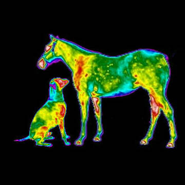
Thermografie Praxis MTP-Ganzheitliche Diagnose
Neustadt
Praxis MTP-Tiertherapien ganzheitliche Diagnostik
@Praxis MTP-Tiertherapien ganzh...
Bodenarbeit
Coaching
Sattelberatung
Beratung rund ums Pferd
Tierkommunikation
Kleintierbehandlung (Praxis)
Kleintierbehandlung (vor Ort)
30 weitere...
B+

Osteopathie Praxis MTP-Tiertherapien Ganzheitlich
Neustadt
Praxis MTP-Tiertherapien ganzheitliche Diagnostik
@Praxis MTP-Tiertherapien ganzh...
Bewegungstrainer
Bodenarbeit
Sattelberatung
Beratung rund ums Pferd
Sonstiges
Kleintierbehandlung (Praxis)
Kleintierbehandlung (vor Ort)
36 weitere...
B+
Leider kein Vorschaubild
Leider kein Vorschaubild
Personal Training für das Pferd
Uetze
Freude mit und am Pferd
@FreudemitdemPferd
gymnastizierende Arbeit an der Hand
Trainerschein: C
Beratung rund ums Pferd
neu
B+

OsteoVet Dr. med. vet. Yvonne Marschall
Rehburg-Loccum
OsteoVet Dr. Yvonne Marschall
@OsteoVet_Dr_Yvonne_Marschall
Pferdephysiotherapeut
Kleintierbehandlung (Praxis)
Kleintierbehandlung (vor Ort)
Akupressur
Akupunktur
8 weitere...
B+

Mobile Pferdewaage und AE Tier Physio
Burgdorf
AE Tier Physio
@AETierPhysioHannoverBurgdorf
Bewegungstrainer
Coaching
Beratung rund ums Pferd
mobile Waage
Akupressur
Akupunktmassage nach Penzel
9 weitere...
B+
Leider kein Vorschaubild
Leider kein Vorschaubild
Stallhilfedienstleistungen
Langenhagen
Bau-Baron. Baron Gruppen
@BauBaronStalldienstleister
Lohnunternehmen
B+

Heu und Heulage verkaufen
Mechtersen
STALL-FREIde Marketing
@STALL-FREI-Marketing
Verkaufen Sie Ihr Heu und Ihre Heulage direkt an Reiter, Pferdeställe und Reitanlagen

Pension & Reiterhof Dossow, Barbara Gamon
Wittstock/Dosse
Pension & Reiterhof Dossow
@Pension & Reiterhof Dossow
Kinderreitkurse
Pferdeausbildung
Pferdevermittlung
Pferdesitting
Beratung rund ums Pferd
5 weitere...
B+

Ausbildung Pferdeosteopathie-/Physiotherapie
Raddestorf
Equi-Power
@Equi-Power
Pferdephysiotherapeut
Trainerschein: A
Hufpfleger
Hufschuhberatung/Hufschuhverleih
Fohlenzucht
7 weitere...
B+
Dienstleister mit Pferdephysiotherapeut
Angebote mit Reitunterricht: Dressur
Anbieter mit Hufpfleger
Deprecated: Creation of dynamic property Zend_View::$pageCount is deprecated in /var/www/stall-frei/htdocs/staging.stall-frei.de/library/vendor/shardj/zf1-future/library/Zend/View/Abstract.php on line 308
Deprecated: Creation of dynamic property Zend_View::$itemCountPerPage is deprecated in /var/www/stall-frei/htdocs/staging.stall-frei.de/library/vendor/shardj/zf1-future/library/Zend/View/Abstract.php on line 308
Deprecated: Creation of dynamic property Zend_View::$first is deprecated in /var/www/stall-frei/htdocs/staging.stall-frei.de/library/vendor/shardj/zf1-future/library/Zend/View/Abstract.php on line 308
Deprecated: Creation of dynamic property Zend_View::$current is deprecated in /var/www/stall-frei/htdocs/staging.stall-frei.de/library/vendor/shardj/zf1-future/library/Zend/View/Abstract.php on line 308
Deprecated: Creation of dynamic property Zend_View::$last is deprecated in /var/www/stall-frei/htdocs/staging.stall-frei.de/library/vendor/shardj/zf1-future/library/Zend/View/Abstract.php on line 308
Deprecated: Creation of dynamic property Zend_View::$previous is deprecated in /var/www/stall-frei/htdocs/staging.stall-frei.de/library/vendor/shardj/zf1-future/library/Zend/View/Abstract.php on line 308
Deprecated: Creation of dynamic property Zend_View::$next is deprecated in /var/www/stall-frei/htdocs/staging.stall-frei.de/library/vendor/shardj/zf1-future/library/Zend/View/Abstract.php on line 308
Deprecated: Creation of dynamic property Zend_View::$pagesInRange is deprecated in /var/www/stall-frei/htdocs/staging.stall-frei.de/library/vendor/shardj/zf1-future/library/Zend/View/Abstract.php on line 308
Deprecated: Creation of dynamic property Zend_View::$firstPageInRange is deprecated in /var/www/stall-frei/htdocs/staging.stall-frei.de/library/vendor/shardj/zf1-future/library/Zend/View/Abstract.php on line 308
Deprecated: Creation of dynamic property Zend_View::$lastPageInRange is deprecated in /var/www/stall-frei/htdocs/staging.stall-frei.de/library/vendor/shardj/zf1-future/library/Zend/View/Abstract.php on line 308
Deprecated: Creation of dynamic property Zend_View::$currentItemCount is deprecated in /var/www/stall-frei/htdocs/staging.stall-frei.de/library/vendor/shardj/zf1-future/library/Zend/View/Abstract.php on line 308
Deprecated: Creation of dynamic property Zend_View::$totalItemCount is deprecated in /var/www/stall-frei/htdocs/staging.stall-frei.de/library/vendor/shardj/zf1-future/library/Zend/View/Abstract.php on line 308
Deprecated: Creation of dynamic property Zend_View::$firstItemNumber is deprecated in /var/www/stall-frei/htdocs/staging.stall-frei.de/library/vendor/shardj/zf1-future/library/Zend/View/Abstract.php on line 308
Deprecated: Creation of dynamic property Zend_View::$lastItemNumber is deprecated in /var/www/stall-frei/htdocs/staging.stall-frei.de/library/vendor/shardj/zf1-future/library/Zend/View/Abstract.php on line 308
Deprecated: Creation of dynamic property Zend_View::$router is deprecated in /var/www/stall-frei/htdocs/staging.stall-frei.de/library/vendor/shardj/zf1-future/library/Zend/View/Abstract.php on line 308
Deprecated: Creation of dynamic property Zend_View::$urlParams is deprecated in /var/www/stall-frei/htdocs/staging.stall-frei.de/library/vendor/shardj/zf1-future/library/Zend/View/Abstract.php on line 308
Deprecated: Creation of dynamic property Zend_View::$showAds is deprecated in /var/www/stall-frei/htdocs/staging.stall-frei.de/library/vendor/shardj/zf1-future/library/Zend/View/Abstract.php on line 308
Deprecated: Creation of dynamic property Zend_View::$objectIds is deprecated in /var/www/stall-frei/htdocs/staging.stall-frei.de/library/vendor/shardj/zf1-future/library/Zend/View/Abstract.php on line 308
Deprecated: Creation of dynamic property Zend_View::$showNavbar is deprecated in /var/www/stall-frei/htdocs/staging.stall-frei.de/library/vendor/shardj/zf1-future/library/Zend/View/Abstract.php on line 308
Deprecated: Creation of dynamic property Zend_View::$showBreadcrumb is deprecated in /var/www/stall-frei/htdocs/staging.stall-frei.de/library/vendor/shardj/zf1-future/library/Zend/View/Abstract.php on line 308
Deprecated: Creation of dynamic property Zend_View::$showFooter is deprecated in /var/www/stall-frei/htdocs/staging.stall-frei.de/library/vendor/shardj/zf1-future/library/Zend/View/Abstract.php on line 308
Deprecated: Creation of dynamic property Zend_View::$showInternalAds is deprecated in /var/www/stall-frei/htdocs/staging.stall-frei.de/library/vendor/shardj/zf1-future/library/Zend/View/Abstract.php on line 308
Deprecated: Creation of dynamic property Zend_View::$blNoContent is deprecated in /var/www/stall-frei/htdocs/staging.stall-frei.de/library/vendor/shardj/zf1-future/library/Zend/View/Abstract.php on line 308
Deprecated: Creation of dynamic property Zend_View::$sMetaDesc is deprecated in /var/www/stall-frei/htdocs/staging.stall-frei.de/library/vendor/shardj/zf1-future/library/Zend/View/Abstract.php on line 308
Deprecated: Creation of dynamic property Zend_View::$useGmaps is deprecated in /var/www/stall-frei/htdocs/staging.stall-frei.de/library/vendor/shardj/zf1-future/library/Zend/View/Abstract.php on line 308
Deprecated: Creation of dynamic property Zend_View::$touches is deprecated in /var/www/stall-frei/htdocs/staging.stall-frei.de/library/vendor/shardj/zf1-future/library/Zend/View/Abstract.php on line 308
Deprecated: Creation of dynamic property Zend_View::$oProject is deprecated in /var/www/stall-frei/htdocs/staging.stall-frei.de/library/vendor/shardj/zf1-future/library/Zend/View/Abstract.php on line 308
Deprecated: Creation of dynamic property Zend_View::$pageHeadline is deprecated in /var/www/stall-frei/htdocs/staging.stall-frei.de/library/vendor/shardj/zf1-future/library/Zend/View/Abstract.php on line 308
Deprecated: Creation of dynamic property Zend_View::$disableLocationField is deprecated in /var/www/stall-frei/htdocs/staging.stall-frei.de/library/vendor/shardj/zf1-future/library/Zend/View/Abstract.php on line 308
Deprecated: Creation of dynamic property Zend_View::$isSearch is deprecated in /var/www/stall-frei/htdocs/staging.stall-frei.de/library/vendor/shardj/zf1-future/library/Zend/View/Abstract.php on line 308
Deprecated: Creation of dynamic property Zend_View::$pageTitle is deprecated in /var/www/stall-frei/htdocs/staging.stall-frei.de/library/vendor/shardj/zf1-future/library/Zend/View/Abstract.php on line 308
Deprecated: Creation of dynamic property Psf_Form_Element_Text::$class is deprecated in /var/www/stall-frei/htdocs/staging.stall-frei.de/library/vendor/shardj/zf1-future/library/Zend/Form/Element.php on line 874
Deprecated: Creation of dynamic property Psf_Form_Element_Text::$size is deprecated in /var/www/stall-frei/htdocs/staging.stall-frei.de/library/vendor/shardj/zf1-future/library/Zend/Form/Element.php on line 874
Deprecated: Creation of dynamic property Psf_Form_Element_Text::$placeholder is deprecated in /var/www/stall-frei/htdocs/staging.stall-frei.de/library/vendor/shardj/zf1-future/library/Zend/Form/Element.php on line 874
Deprecated: Creation of dynamic property Psf_Form_Element_Hidden::$class is deprecated in /var/www/stall-frei/htdocs/staging.stall-frei.de/library/vendor/shardj/zf1-future/library/Zend/Form/Element.php on line 874
Deprecated: Creation of dynamic property Psf_Form_Element_Hidden::$class is deprecated in /var/www/stall-frei/htdocs/staging.stall-frei.de/library/vendor/shardj/zf1-future/library/Zend/Form/Element.php on line 874
Deprecated: Creation of dynamic property Psf_Form_Element_Hidden::$class is deprecated in /var/www/stall-frei/htdocs/staging.stall-frei.de/library/vendor/shardj/zf1-future/library/Zend/Form/Element.php on line 874
Deprecated: Creation of dynamic property Psf_Form_Element_Hidden::$class is deprecated in /var/www/stall-frei/htdocs/staging.stall-frei.de/library/vendor/shardj/zf1-future/library/Zend/Form/Element.php on line 874
Deprecated: Creation of dynamic property Psf_Form_Element_Select::$class is deprecated in /var/www/stall-frei/htdocs/staging.stall-frei.de/library/vendor/shardj/zf1-future/library/Zend/Form/Element.php on line 874
Deprecated: Creation of dynamic property Psf_Form_Element_Text::$class is deprecated in /var/www/stall-frei/htdocs/staging.stall-frei.de/library/vendor/shardj/zf1-future/library/Zend/Form/Element.php on line 874
Deprecated: Creation of dynamic property Psf_Form_Element_Checkbox::$label is deprecated in /var/www/stall-frei/htdocs/staging.stall-frei.de/library/vendor/shardj/zf1-future/library/Zend/Form/Element.php on line 874
Deprecated: Creation of dynamic property Zend_View::$sort is deprecated in /var/www/stall-frei/htdocs/staging.stall-frei.de/library/vendor/shardj/zf1-future/library/Zend/View/Abstract.php on line 308
Deprecated: Creation of dynamic property Zend_View::$searchLocation is deprecated in /var/www/stall-frei/htdocs/staging.stall-frei.de/library/vendor/shardj/zf1-future/library/Zend/View/Abstract.php on line 308
Deprecated: Creation of dynamic property Zend_View::$locationHint is deprecated in /var/www/stall-frei/htdocs/staging.stall-frei.de/library/vendor/shardj/zf1-future/library/Zend/View/Abstract.php on line 308
Psf_GeoCoder_Abstract::getLocation: Ahneby Get Location CachedOrLive
Psf_GeoCoder_Abstract::getCachedOrLive: Ahneby
Psf_GeoCoder_Abstract::convertLocationResult
{"documentation":"https:\/\/opencagedata.com\/api","licenses":[{"name":"see attribution guide","url":"https:\/\/opencagedata.com\/credits"}],"results":[{"bounds":{"northeast":{"lat":54.7156871,"lng":9.7489346},"southwest":{"lat":54.6947955,"lng":9.7094146}},"components":{"ISO_3166-1_alpha-2":"DE","ISO_3166-1_alpha-3":"DEU","ISO_3166-2":["DE-SH"],"_category":"place","_normalized_city":"Ahneby","_type":"village","continent":"Europe","country":"Deutschland","country_code":"de","county":"Kreis Schleswig-Flensburg","municipality":"Geltinger Bucht","political_union":"European Union","state":"Schleswig-Holstein","state_code":"SH","village":"Ahneby"},"confidence":7,"formatted":"Ahneby, Schleswig-Holstein, Deutschland","geometry":{"lat":54.7018498,"lng":9.7314202}},{"components":{"ISO_3166-1_alpha-2":"FR","ISO_3166-1_alpha-3":"FRA","ISO_3166-2":["FR-IDF","FR-92"],"_category":"road","_normalized_city":"Levallois-Perret","_type":"road","city":"Levallois-Perret","continent":"Europe","country":"France","country_code":"fr","county":"Hauts-de-Seine","local_authority":"M\u00e9tropole du Grand Paris","political_union":"European Union","postcode":"92300","road":"Rue Charles Deutschmann","state":"\u00cele-de-France","state_code":"IDF"},"confidence":2,"formatted":"Rue Charles Deutschmann, 92300 Levallois-Perret, France","geometry":{"lat":48.900049,"lng":2.2842}},{"components":{"ISO_3166-1_alpha-2":"FR","ISO_3166-1_alpha-3":"FRA","ISO_3166-2":["FR-CVL","FR-18"],"_category":"road","_normalized_city":"M\u00e9ry-\u00e8s-Bois","_type":"road","city":"M\u00e9ry-\u00e8s-Bois","continent":"Europe","country":"France","country_code":"fr","county":"Cher","local_authority":"Communaut\u00e9 de communes Sauldre et Sologne","political_union":"European Union","postcode":"18380","road":"Route de l\u2019Anerie","state":"Centre-Val de Loire","state_code":"CVL"},"confidence":10,"formatted":"Route de l\u2019Anerie, 18380 M\u00e9ry-\u00e8s-Bois, France","geometry":{"lat":47.309954,"lng":2.361104}},{"components":{"ISO_3166-1_alpha-2":"FR","ISO_3166-1_alpha-3":"FRA","ISO_3166-2":["FR-PDL","FR-49"],"_category":"road","_normalized_city":"Allonnes","_type":"road","city":"Allonnes","continent":"Europe","country":"France","country_code":"fr","county":"Maine-et-Loire","local_authority":"Communaut\u00e9 d'agglom\u00e9ration Saumur Val de Loire","political_union":"European Union","postcode":"49650","road":"Route de l'Anerie","state":"Pays de la Loire","state_code":"PDL"},"confidence":10,"formatted":"Route de l'Anerie, 49650 Allonnes, France","geometry":{"lat":47.327582,"lng":0.010674}},{"components":{"ISO_3166-1_alpha-2":"FR","ISO_3166-1_alpha-3":"FRA","ISO_3166-2":["FR-NOR","FR-50"],"_category":"road","_normalized_city":"Barenton","_type":"road","city":"Barenton","continent":"Europe","country":"France","country_code":"fr","county":"Manche","local_authority":"Communaut\u00e9 d'agglom\u00e9ration Mont-Saint-Michel-Normandie","political_union":"European Union","postcode":"50720","road":"Route de la Haute Anerie","state":"Normandie","state_code":"NOR"},"confidence":10,"formatted":"Route de la Haute Anerie, 50720 Barenton, France","geometry":{"lat":48.606473,"lng":-0.801999}},{"components":{"ISO_3166-1_alpha-2":"FR","ISO_3166-1_alpha-3":"FRA","ISO_3166-2":["FR-PDL","FR-72"],"_category":"road","_normalized_city":"Bo\u00ebss\u00e9-le-Sec","_type":"road","city":"Bo\u00ebss\u00e9-le-Sec","continent":"Europe","country":"France","country_code":"fr","county":"Sarthe","local_authority":"Communaut\u00e9 de communes du Pays de l'Huisne Sarthoise","political_union":"European Union","postcode":"72400","road":"Chemin de L Anerie","state":"Pays de la Loire","state_code":"PDL"},"confidence":10,"formatted":"Chemin de L Anerie, 72400 Bo\u00ebss\u00e9-le-Sec, France","geometry":{"lat":48.150699,"lng":0.562239}},{"components":{"ISO_3166-1_alpha-2":"FR","ISO_3166-1_alpha-3":"FRA","ISO_3166-2":["FR-PDL","FR-49"],"_category":"road","_normalized_city":"Chemill\u00e9-en-Anjou","_type":"road","city":"Chemill\u00e9-en-Anjou","continent":"Europe","country":"France","country_code":"fr","county":"Maine-et-Loire","local_authority":"Mauges Communaut\u00e9","political_union":"European Union","postcode":"49120","road":"Rue de l'\u00c2nerie","state":"Pays de la Loire","state_code":"PDL"},"confidence":10,"formatted":"Rue de l'\u00c2nerie, 49120 Chemill\u00e9-en-Anjou, France","geometry":{"lat":47.150811,"lng":-0.735788}},{"components":{"ISO_3166-1_alpha-2":"FR","ISO_3166-1_alpha-3":"FRA","ISO_3166-2":["FR-CVL","FR-45"],"_category":"road","_normalized_city":"Loury","_type":"road","city":"Loury","continent":"Europe","country":"France","country_code":"fr","county":"Loiret","local_authority":"Communaut\u00e9 de communes de la For\u00eat","political_union":"European Union","postcode":"45470","road":"Rue de l'Anerie","state":"Centre-Val de Loire","state_code":"CVL"},"confidence":10,"formatted":"Rue de l'Anerie, 45470 Loury, France","geometry":{"lat":47.997399,"lng":2.100758}},{"components":{"ISO_3166-1_alpha-2":"FR","ISO_3166-1_alpha-3":"FRA","ISO_3166-2":["FR-NAQ","FR-17"],"_category":"road","_normalized_city":"La Couarde-sur-Mer","_type":"road","city":"La Couarde-sur-Mer","continent":"Europe","country":"France","country_code":"fr","county":"Charente-Maritime","local_authority":"Communaut\u00e9 de communes de l'\u00cele de R\u00e9","political_union":"European Union","postcode":"17670","road":"Rue des Anneries","state":"Nouvelle-Aquitaine","state_code":"NAQ"},"confidence":10,"formatted":"Rue des Anneries, 17670 La Couarde-sur-Mer, France","geometry":{"lat":46.190701,"lng":-1.425232}},{"components":{"ISO_3166-1_alpha-2":"FR","ISO_3166-1_alpha-3":"FRA","ISO_3166-2":["FR-CVL","FR-18"],"_category":"road","_normalized_city":"Bannay","_type":"road","city":"Bannay","continent":"Europe","country":"France","country_code":"fr","county":"Cher","local_authority":"Communaut\u00e9 de communes Pays Fort Sancerrois Val de Loire","political_union":"European Union","postcode":"18300","road":"Rue de l'Anerie","state":"Centre-Val de Loire","state_code":"CVL"},"confidence":10,"formatted":"Rue de l'Anerie, 18300 Bannay, France","geometry":{"lat":47.391145,"lng":2.88713}}],"status":{"code":200,"message":"OK"},"stay_informed":{"blog":"https:\/\/blog.opencagedata.com","mastodon":"https:\/\/en.osm.town\/@opencage"},"thanks":"For using an OpenCage API","timestamp":{"created_http":"Sat, 07 Feb 2026 08:57:40 GMT","created_unix":1770454660},"total_results":10}Array
(
[0] => stdClass Object
(
[bounds] => stdClass Object
(
[northeast] => stdClass Object
(
[lat] => 54.7156871
[lng] => 9.7489346
)
[southwest] => stdClass Object
(
[lat] => 54.6947955
[lng] => 9.7094146
)
)
[components] => stdClass Object
(
[ISO_3166-1_alpha-2] => DE
[ISO_3166-1_alpha-3] => DEU
[ISO_3166-2] => Array
(
[0] => DE-SH
)
[_category] => place
[_normalized_city] => Ahneby
[_type] => village
[continent] => Europe
[country] => Deutschland
[country_code] => de
[county] => Kreis Schleswig-Flensburg
[municipality] => Geltinger Bucht
[political_union] => European Union
[state] => Schleswig-Holstein
[state_code] => SH
[village] => Ahneby
)
[confidence] => 7
[formatted] => Ahneby, Schleswig-Holstein, Deutschland
[geometry] => stdClass Object
(
[lat] => 54.7018498
[lng] => 9.7314202
)
)
[1] => stdClass Object
(
[components] => stdClass Object
(
[ISO_3166-1_alpha-2] => FR
[ISO_3166-1_alpha-3] => FRA
[ISO_3166-2] => Array
(
[0] => FR-IDF
[1] => FR-92
)
[_category] => road
[_normalized_city] => Levallois-Perret
[_type] => road
[city] => Levallois-Perret
[continent] => Europe
[country] => France
[country_code] => fr
[county] => Hauts-de-Seine
[local_authority] => Métropole du Grand Paris
[political_union] => European Union
[postcode] => 92300
[road] => Rue Charles Deutschmann
[state] => Île-de-France
[state_code] => IDF
)
[confidence] => 2
[formatted] => Rue Charles Deutschmann, 92300 Levallois-Perret, France
[geometry] => stdClass Object
(
[lat] => 48.900049
[lng] => 2.2842
)
)
[2] => stdClass Object
(
[components] => stdClass Object
(
[ISO_3166-1_alpha-2] => FR
[ISO_3166-1_alpha-3] => FRA
[ISO_3166-2] => Array
(
[0] => FR-CVL
[1] => FR-18
)
[_category] => road
[_normalized_city] => Méry-ès-Bois
[_type] => road
[city] => Méry-ès-Bois
[continent] => Europe
[country] => France
[country_code] => fr
[county] => Cher
[local_authority] => Communauté de communes Sauldre et Sologne
[political_union] => European Union
[postcode] => 18380
[road] => Route de l’Anerie
[state] => Centre-Val de Loire
[state_code] => CVL
)
[confidence] => 10
[formatted] => Route de l’Anerie, 18380 Méry-ès-Bois, France
[geometry] => stdClass Object
(
[lat] => 47.309954
[lng] => 2.361104
)
)
[3] => stdClass Object
(
[components] => stdClass Object
(
[ISO_3166-1_alpha-2] => FR
[ISO_3166-1_alpha-3] => FRA
[ISO_3166-2] => Array
(
[0] => FR-PDL
[1] => FR-49
)
[_category] => road
[_normalized_city] => Allonnes
[_type] => road
[city] => Allonnes
[continent] => Europe
[country] => France
[country_code] => fr
[county] => Maine-et-Loire
[local_authority] => Communauté d'agglomération Saumur Val de Loire
[political_union] => European Union
[postcode] => 49650
[road] => Route de l'Anerie
[state] => Pays de la Loire
[state_code] => PDL
)
[confidence] => 10
[formatted] => Route de l'Anerie, 49650 Allonnes, France
[geometry] => stdClass Object
(
[lat] => 47.327582
[lng] => 0.010674
)
)
[4] => stdClass Object
(
[components] => stdClass Object
(
[ISO_3166-1_alpha-2] => FR
[ISO_3166-1_alpha-3] => FRA
[ISO_3166-2] => Array
(
[0] => FR-NOR
[1] => FR-50
)
[_category] => road
[_normalized_city] => Barenton
[_type] => road
[city] => Barenton
[continent] => Europe
[country] => France
[country_code] => fr
[county] => Manche
[local_authority] => Communauté d'agglomération Mont-Saint-Michel-Normandie
[political_union] => European Union
[postcode] => 50720
[road] => Route de la Haute Anerie
[state] => Normandie
[state_code] => NOR
)
[confidence] => 10
[formatted] => Route de la Haute Anerie, 50720 Barenton, France
[geometry] => stdClass Object
(
[lat] => 48.606473
[lng] => -0.801999
)
)
[5] => stdClass Object
(
[components] => stdClass Object
(
[ISO_3166-1_alpha-2] => FR
[ISO_3166-1_alpha-3] => FRA
[ISO_3166-2] => Array
(
[0] => FR-PDL
[1] => FR-72
)
[_category] => road
[_normalized_city] => Boëssé-le-Sec
[_type] => road
[city] => Boëssé-le-Sec
[continent] => Europe
[country] => France
[country_code] => fr
[county] => Sarthe
[local_authority] => Communauté de communes du Pays de l'Huisne Sarthoise
[political_union] => European Union
[postcode] => 72400
[road] => Chemin de L Anerie
[state] => Pays de la Loire
[state_code] => PDL
)
[confidence] => 10
[formatted] => Chemin de L Anerie, 72400 Boëssé-le-Sec, France
[geometry] => stdClass Object
(
[lat] => 48.150699
[lng] => 0.562239
)
)
[6] => stdClass Object
(
[components] => stdClass Object
(
[ISO_3166-1_alpha-2] => FR
[ISO_3166-1_alpha-3] => FRA
[ISO_3166-2] => Array
(
[0] => FR-PDL
[1] => FR-49
)
[_category] => road
[_normalized_city] => Chemillé-en-Anjou
[_type] => road
[city] => Chemillé-en-Anjou
[continent] => Europe
[country] => France
[country_code] => fr
[county] => Maine-et-Loire
[local_authority] => Mauges Communauté
[political_union] => European Union
[postcode] => 49120
[road] => Rue de l'Ânerie
[state] => Pays de la Loire
[state_code] => PDL
)
[confidence] => 10
[formatted] => Rue de l'Ânerie, 49120 Chemillé-en-Anjou, France
[geometry] => stdClass Object
(
[lat] => 47.150811
[lng] => -0.735788
)
)
[7] => stdClass Object
(
[components] => stdClass Object
(
[ISO_3166-1_alpha-2] => FR
[ISO_3166-1_alpha-3] => FRA
[ISO_3166-2] => Array
(
[0] => FR-CVL
[1] => FR-45
)
[_category] => road
[_normalized_city] => Loury
[_type] => road
[city] => Loury
[continent] => Europe
[country] => France
[country_code] => fr
[county] => Loiret
[local_authority] => Communauté de communes de la Forêt
[political_union] => European Union
[postcode] => 45470
[road] => Rue de l'Anerie
[state] => Centre-Val de Loire
[state_code] => CVL
)
[confidence] => 10
[formatted] => Rue de l'Anerie, 45470 Loury, France
[geometry] => stdClass Object
(
[lat] => 47.997399
[lng] => 2.100758
)
)
[8] => stdClass Object
(
[components] => stdClass Object
(
[ISO_3166-1_alpha-2] => FR
[ISO_3166-1_alpha-3] => FRA
[ISO_3166-2] => Array
(
[0] => FR-NAQ
[1] => FR-17
)
[_category] => road
[_normalized_city] => La Couarde-sur-Mer
[_type] => road
[city] => La Couarde-sur-Mer
[continent] => Europe
[country] => France
[country_code] => fr
[county] => Charente-Maritime
[local_authority] => Communauté de communes de l'Île de Ré
[political_union] => European Union
[postcode] => 17670
[road] => Rue des Anneries
[state] => Nouvelle-Aquitaine
[state_code] => NAQ
)
[confidence] => 10
[formatted] => Rue des Anneries, 17670 La Couarde-sur-Mer, France
[geometry] => stdClass Object
(
[lat] => 46.190701
[lng] => -1.425232
)
)
[9] => stdClass Object
(
[components] => stdClass Object
(
[ISO_3166-1_alpha-2] => FR
[ISO_3166-1_alpha-3] => FRA
[ISO_3166-2] => Array
(
[0] => FR-CVL
[1] => FR-18
)
[_category] => road
[_normalized_city] => Bannay
[_type] => road
[city] => Bannay
[continent] => Europe
[country] => France
[country_code] => fr
[county] => Cher
[local_authority] => Communauté de communes Pays Fort Sancerrois Val de Loire
[political_union] => European Union
[postcode] => 18300
[road] => Rue de l'Anerie
[state] => Centre-Val de Loire
[state_code] => CVL
)
[confidence] => 10
[formatted] => Rue de l'Anerie, 18300 Bannay, France
[geometry] => stdClass Object
(
[lat] => 47.391145
[lng] => 2.88713
)
)
)
Psf_GeoCoder_OpenCageData::getKeyMap: 0
stdClass Object
(
    [bounds] => stdClass Object
        (
            [northeast] => stdClass Object
                (
                    [lat] => 54.7156871
                    [lng] => 9.7489346
                )

            [southwest] => stdClass Object
                (
                    [lat] => 54.6947955
                    [lng] => 9.7094146
                )

        )

    [components] => stdClass Object
        (
            [ISO_3166-1_alpha-2] => DE
            [ISO_3166-1_alpha-3] => DEU
            [ISO_3166-2] => Array
                (
                    [0] => DE-SH
                )

            [_category] => place
            [_normalized_city] => Ahneby
            [_type] => village
            [continent] => Europe
            [country] => Deutschland
            [country_code] => de
            [county] => Kreis Schleswig-Flensburg
            [municipality] => Geltinger Bucht
            [political_union] => European Union
            [state] => Schleswig-Holstein
            [state_code] => SH
            [village] => Ahneby
        )

    [confidence] => 7
    [formatted] => Ahneby, Schleswig-Holstein, Deutschland
    [geometry] => stdClass Object
        (
            [lat] => 54.7018498
            [lng] => 9.7314202
        )

)
Psf_GeoCoder_OpenCageData::getCounty: Schleswig-Flensburg
Psf_GeoCoder_OpenCageData::addMissingData REFETCH!
Array
(
    [address] => Ahneby, Schleswig-Holstein, Deutschland
    [type] => village
    [street] =>
    [city] => Ahneby
    [county] => Schleswig-Flensburg
    [state] => Schleswig-Holstein
    [zip] =>
    [country] => Deutschland
    [suburb] =>
    [countrycode] => de
    [latitude] => 54.7018498
    [longitude] => 9.7314202
    [accuracy] => 1
    [confidence] => 7
    [bounds] => stdClass Object
        (
            [northeast] => stdClass Object
                (
                    [lat] => 54.7156871
                    [lng] => 9.7489346
                )

            [southwest] => stdClass Object
                (
                    [lat] => 54.6947955
                    [lng] => 9.7094146
                )

        )

)
reformat!
Array
(
    [address] => Ahneby, Schleswig-Holstein, Deutschland
    [type] => village
    [street] =>
    [city] => Ahneby
    [county] => Schleswig-Flensburg
    [state] => Schleswig-Holstein
    [zip] =>
    [country] => Deutschland
    [suburb] =>
    [countrycode] => de
    [latitude] => 54.7018498
    [longitude] => 9.7314202
    [accuracy] => 1
    [confidence] => 7
    [bounds] => stdClass Object
        (
            [northeast] => stdClass Object
                (
                    [lat] => 54.7156871
                    [lng] => 9.7489346
                )

            [southwest] => stdClass Object
                (
                    [lat] => 54.6947955
                    [lng] => 9.7094146
                )

        )

    [place] => Ahneby, Schleswig-Holstein
    [hash] => 16df98e75c5dd6420153926cea230d9c
)
Psf_GeoCoder_OpenCageData::getKeyMap: 1
stdClass Object
(
    [components] => stdClass Object
        (
            [ISO_3166-1_alpha-2] => FR
            [ISO_3166-1_alpha-3] => FRA
            [ISO_3166-2] => Array
                (
                    [0] => FR-IDF
                    [1] => FR-92
                )

            [_category] => road
            [_normalized_city] => Levallois-Perret
            [_type] => road
            [city] => Levallois-Perret
            [continent] => Europe
            [country] => France
            [country_code] => fr
            [county] => Hauts-de-Seine
            [local_authority] => Métropole du Grand Paris
            [political_union] => European Union
            [postcode] => 92300
            [road] => Rue Charles Deutschmann
            [state] => Île-de-France
            [state_code] => IDF
        )

    [confidence] => 2
    [formatted] => Rue Charles Deutschmann, 92300 Levallois-Perret, France
    [geometry] => stdClass Object
        (
            [lat] => 48.900049
            [lng] => 2.2842
        )

)
Psf_GeoCoder_OpenCageData::getCounty: Hauts-de-Seine
Psf_GeoCoder_OpenCageData::addMissingData REFETCH!
Array
(
    [address] => Rue Charles Deutschmann, 92300 Levallois-Perret, France
    [type] => road
    [street] => Rue Charles Deutschmann
    [city] => Levallois-Perret
    [county] => Hauts-de-Seine
    [state] => Île-de-France
    [zip] => 92300
    [country] => France
    [suburb] =>
    [countrycode] => fr
    [latitude] => 48.900049
    [longitude] => 2.2842
    [accuracy] => 1
    [confidence] => 2
    [bounds] =>
)
reformat!
Array
(
    [address] => Rue Charles Deutschmann, 92300 Levallois-Perret, France
    [type] => road
    [street] => Rue Charles Deutschmann
    [city] => Levallois-Perret
    [county] => Hauts-de-Seine
    [state] => Île-de-France
    [zip] => 92300
    [country] => France
    [suburb] =>
    [countrycode] => fr
    [latitude] => 48.900049
    [longitude] => 2.2842
    [accuracy] => 1
    [confidence] => 2
    [bounds] =>
    [place] => Rue Charles Deutschmann, 92300 Levallois-Perret, Île-de-France
    [hash] => b7dc44def3990e8a7eaf18e019eca466
)
Psf_GeoCoder_OpenCageData::getKeyMap: 2
stdClass Object
(
    [components] => stdClass Object
        (
            [ISO_3166-1_alpha-2] => FR
            [ISO_3166-1_alpha-3] => FRA
            [ISO_3166-2] => Array
                (
                    [0] => FR-CVL
                    [1] => FR-18
                )

            [_category] => road
            [_normalized_city] => Méry-ès-Bois
            [_type] => road
            [city] => Méry-ès-Bois
            [continent] => Europe
            [country] => France
            [country_code] => fr
            [county] => Cher
            [local_authority] => Communauté de communes Sauldre et Sologne
            [political_union] => European Union
            [postcode] => 18380
            [road] => Route de l’Anerie
            [state] => Centre-Val de Loire
            [state_code] => CVL
        )

    [confidence] => 10
    [formatted] => Route de l’Anerie, 18380 Méry-ès-Bois, France
    [geometry] => stdClass Object
        (
            [lat] => 47.309954
            [lng] => 2.361104
        )

)
Psf_GeoCoder_OpenCageData::getCounty: Cher
Psf_GeoCoder_OpenCageData::addMissingData REFETCH!
Array
(
    [address] => Route de l’Anerie, 18380 Méry-ès-Bois, France
    [type] => road
    [street] => Route de l’Anerie
    [city] => Méry-ès-Bois
    [county] => Cher
    [state] => Centre-Val de Loire
    [zip] => 18380
    [country] => France
    [suburb] =>
    [countrycode] => fr
    [latitude] => 47.309954
    [longitude] => 2.361104
    [accuracy] => 1
    [confidence] => 10
    [bounds] =>
)
reformat!
Array
(
    [address] => Route de l’Anerie, 18380 Méry-ès-Bois, France
    [type] => road
    [street] => Route de l’Anerie
    [city] => Méry-ès-Bois
    [county] => Cher
    [state] => Centre-Val de Loire
    [zip] => 18380
    [country] => France
    [suburb] =>
    [countrycode] => fr
    [latitude] => 47.309954
    [longitude] => 2.361104
    [accuracy] => 1
    [confidence] => 10
    [bounds] =>
    [place] => Route de l’Anerie, 18380 Méry-ès-Bois, Centre-Val de Loire
    [hash] => fa781a2b3f89c819e97eefee8559b9da
)
Psf_GeoCoder_OpenCageData::getKeyMap: 3
stdClass Object
(
    [components] => stdClass Object
        (
            [ISO_3166-1_alpha-2] => FR
            [ISO_3166-1_alpha-3] => FRA
            [ISO_3166-2] => Array
                (
                    [0] => FR-PDL
                    [1] => FR-49
                )

            [_category] => road
            [_normalized_city] => Allonnes
            [_type] => road
            [city] => Allonnes
            [continent] => Europe
            [country] => France
            [country_code] => fr
            [county] => Maine-et-Loire
            [local_authority] => Communauté d'agglomération Saumur Val de Loire
            [political_union] => European Union
            [postcode] => 49650
            [road] => Route de l'Anerie
            [state] => Pays de la Loire
            [state_code] => PDL
        )

    [confidence] => 10
    [formatted] => Route de l'Anerie, 49650 Allonnes, France
    [geometry] => stdClass Object
        (
            [lat] => 47.327582
            [lng] => 0.010674
        )

)
Psf_GeoCoder_OpenCageData::getCounty: Maine-et-Loire
Psf_GeoCoder_OpenCageData::addMissingData REFETCH!
Array
(
    [address] => Route de l'Anerie, 49650 Allonnes, France
    [type] => road
    [street] => Route de l'Anerie
    [city] => Allonnes
    [county] => Maine-et-Loire
    [state] => Pays de la Loire
    [zip] => 49650
    [country] => France
    [suburb] =>
    [countrycode] => fr
    [latitude] => 47.327582
    [longitude] => 0.010674
    [accuracy] => 1
    [confidence] => 10
    [bounds] =>
)
reformat!
Array
(
    [address] => Route de l'Anerie, 49650 Allonnes, France
    [type] => road
    [street] => Route de l'Anerie
    [city] => Allonnes
    [county] => Maine-et-Loire
    [state] => Pays de la Loire
    [zip] => 49650
    [country] => France
    [suburb] =>
    [countrycode] => fr
    [latitude] => 47.327582
    [longitude] => 0.010674
    [accuracy] => 1
    [confidence] => 10
    [bounds] =>
    [place] => Route de l'Anerie, 49650 Allonnes, Pays de la Loire
    [hash] => 3484e6c2e96dbd572ca341e63d8821fc
)
Psf_GeoCoder_OpenCageData::getKeyMap: 4
stdClass Object
(
    [components] => stdClass Object
        (
            [ISO_3166-1_alpha-2] => FR
            [ISO_3166-1_alpha-3] => FRA
            [ISO_3166-2] => Array
                (
                    [0] => FR-NOR
                    [1] => FR-50
                )

            [_category] => road
            [_normalized_city] => Barenton
            [_type] => road
            [city] => Barenton
            [continent] => Europe
            [country] => France
            [country_code] => fr
            [county] => Manche
            [local_authority] => Communauté d'agglomération Mont-Saint-Michel-Normandie
            [political_union] => European Union
            [postcode] => 50720
            [road] => Route de la Haute Anerie
            [state] => Normandie
            [state_code] => NOR
        )

    [confidence] => 10
    [formatted] => Route de la Haute Anerie, 50720 Barenton, France
    [geometry] => stdClass Object
        (
            [lat] => 48.606473
            [lng] => -0.801999
        )

)
Psf_GeoCoder_OpenCageData::getCounty: Manche
Psf_GeoCoder_OpenCageData::addMissingData REFETCH!
Array
(
    [address] => Route de la Haute Anerie, 50720 Barenton, France
    [type] => road
    [street] => Route de la Haute Anerie
    [city] => Barenton
    [county] => Manche
    [state] => Normandie
    [zip] => 50720
    [country] => France
    [suburb] =>
    [countrycode] => fr
    [latitude] => 48.606473
    [longitude] => -0.801999
    [accuracy] => 1
    [confidence] => 10
    [bounds] =>
)
reformat!
Array
(
    [address] => Route de la Haute Anerie, 50720 Barenton, France
    [type] => road
    [street] => Route de la Haute Anerie
    [city] => Barenton
    [county] => Manche
    [state] => Normandie
    [zip] => 50720
    [country] => France
    [suburb] =>
    [countrycode] => fr
    [latitude] => 48.606473
    [longitude] => -0.801999
    [accuracy] => 1
    [confidence] => 10
    [bounds] =>
    [place] => Route de la Haute Anerie, 50720 Barenton, Normandie
    [hash] => fea35479c41627f12ac64f65a76b4e43
)
Psf_GeoCoder_OpenCageData::getKeyMap: 5
stdClass Object
(
    [components] => stdClass Object
        (
            [ISO_3166-1_alpha-2] => FR
            [ISO_3166-1_alpha-3] => FRA
            [ISO_3166-2] => Array
                (
                    [0] => FR-PDL
                    [1] => FR-72
                )

            [_category] => road
            [_normalized_city] => Boëssé-le-Sec
            [_type] => road
            [city] => Boëssé-le-Sec
            [continent] => Europe
            [country] => France
            [country_code] => fr
            [county] => Sarthe
            [local_authority] => Communauté de communes du Pays de l'Huisne Sarthoise
            [political_union] => European Union
            [postcode] => 72400
            [road] => Chemin de L Anerie
            [state] => Pays de la Loire
            [state_code] => PDL
        )

    [confidence] => 10
    [formatted] => Chemin de L Anerie, 72400 Boëssé-le-Sec, France
    [geometry] => stdClass Object
        (
            [lat] => 48.150699
            [lng] => 0.562239
        )

)
Psf_GeoCoder_OpenCageData::getCounty: Sarthe
Psf_GeoCoder_OpenCageData::addMissingData REFETCH!
Array
(
    [address] => Chemin de L Anerie, 72400 Boëssé-le-Sec, France
    [type] => road
    [street] => Chemin de L Anerie
    [city] => Boëssé-le-Sec
    [county] => Sarthe
    [state] => Pays de la Loire
    [zip] => 72400
    [country] => France
    [suburb] =>
    [countrycode] => fr
    [latitude] => 48.150699
    [longitude] => 0.562239
    [accuracy] => 1
    [confidence] => 10
    [bounds] =>
)
reformat!
Array
(
    [address] => Chemin de L Anerie, 72400 Boëssé-le-Sec, France
    [type] => road
    [street] => Chemin de L Anerie
    [city] => Boëssé-le-Sec
    [county] => Sarthe
    [state] => Pays de la Loire
    [zip] => 72400
    [country] => France
    [suburb] =>
    [countrycode] => fr
    [latitude] => 48.150699
    [longitude] => 0.562239
    [accuracy] => 1
    [confidence] => 10
    [bounds] =>
    [place] => Chemin de L Anerie, 72400 Boëssé-le-Sec, Pays de la Loire
    [hash] => 4bd16e8fb79afdd41c4f5163c645fbab
)
Psf_GeoCoder_OpenCageData::getKeyMap: 6
stdClass Object
(
    [components] => stdClass Object
        (
            [ISO_3166-1_alpha-2] => FR
            [ISO_3166-1_alpha-3] => FRA
            [ISO_3166-2] => Array
                (
                    [0] => FR-PDL
                    [1] => FR-49
                )

            [_category] => road
            [_normalized_city] => Chemillé-en-Anjou
            [_type] => road
            [city] => Chemillé-en-Anjou
            [continent] => Europe
            [country] => France
            [country_code] => fr
            [county] => Maine-et-Loire
            [local_authority] => Mauges Communauté
            [political_union] => European Union
            [postcode] => 49120
            [road] => Rue de l'Ânerie
            [state] => Pays de la Loire
            [state_code] => PDL
        )

    [confidence] => 10
    [formatted] => Rue de l'Ânerie, 49120 Chemillé-en-Anjou, France
    [geometry] => stdClass Object
        (
            [lat] => 47.150811
            [lng] => -0.735788
        )

)
Psf_GeoCoder_OpenCageData::getCounty: Maine-et-Loire
Psf_GeoCoder_OpenCageData::addMissingData REFETCH!
Array
(
    [address] => Rue de l'Ânerie, 49120 Chemillé-en-Anjou, France
    [type] => road
    [street] => Rue de l'Ânerie
    [city] => Chemillé-en-Anjou
    [county] => Maine-et-Loire
    [state] => Pays de la Loire
    [zip] => 49120
    [country] => France
    [suburb] =>
    [countrycode] => fr
    [latitude] => 47.150811
    [longitude] => -0.735788
    [accuracy] => 1
    [confidence] => 10
    [bounds] =>
)
reformat!
Array
(
    [address] => Rue de l'Ânerie, 49120 Chemillé-en-Anjou, France
    [type] => road
    [street] => Rue de l'Ânerie
    [city] => Chemillé-en-Anjou
    [county] => Maine-et-Loire
    [state] => Pays de la Loire
    [zip] => 49120
    [country] => France
    [suburb] =>
    [countrycode] => fr
    [latitude] => 47.150811
    [longitude] => -0.735788
    [accuracy] => 1
    [confidence] => 10
    [bounds] =>
    [place] => Rue de l'Ânerie, 49120 Chemillé-en-Anjou, Pays de la Loire
    [hash] => 5b04caa639447a52d4c4c67aba513aeb
)
Psf_GeoCoder_OpenCageData::getKeyMap: 7
stdClass Object
(
    [components] => stdClass Object
        (
            [ISO_3166-1_alpha-2] => FR
            [ISO_3166-1_alpha-3] => FRA
            [ISO_3166-2] => Array
                (
                    [0] => FR-CVL
                    [1] => FR-45
                )

            [_category] => road
            [_normalized_city] => Loury
            [_type] => road
            [city] => Loury
            [continent] => Europe
            [country] => France
            [country_code] => fr
            [county] => Loiret
            [local_authority] => Communauté de communes de la Forêt
            [political_union] => European Union
            [postcode] => 45470
            [road] => Rue de l'Anerie
            [state] => Centre-Val de Loire
            [state_code] => CVL
        )

    [confidence] => 10
    [formatted] => Rue de l'Anerie, 45470 Loury, France
    [geometry] => stdClass Object
        (
            [lat] => 47.997399
            [lng] => 2.100758
        )

)
Psf_GeoCoder_OpenCageData::getCounty: Loiret
Psf_GeoCoder_OpenCageData::addMissingData REFETCH!
Array
(
    [address] => Rue de l'Anerie, 45470 Loury, France
    [type] => road
    [street] => Rue de l'Anerie
    [city] => Loury
    [county] => Loiret
    [state] => Centre-Val de Loire
    [zip] => 45470
    [country] => France
    [suburb] =>
    [countrycode] => fr
    [latitude] => 47.997399
    [longitude] => 2.100758
    [accuracy] => 1
    [confidence] => 10
    [bounds] =>
)
reformat!
Array
(
    [address] => Rue de l'Anerie, 45470 Loury, France
    [type] => road
    [street] => Rue de l'Anerie
    [city] => Loury
    [county] => Loiret
    [state] => Centre-Val de Loire
    [zip] => 45470
    [country] => France
    [suburb] =>
    [countrycode] => fr
    [latitude] => 47.997399
    [longitude] => 2.100758
    [accuracy] => 1
    [confidence] => 10
    [bounds] =>
    [place] => Rue de l'Anerie, 45470 Loury, Centre-Val de Loire
    [hash] => 5f320bd244f57643ed39cfb9d8139f16
)
Psf_GeoCoder_OpenCageData::getKeyMap: 8
stdClass Object
(
    [components] => stdClass Object
        (
            [ISO_3166-1_alpha-2] => FR
            [ISO_3166-1_alpha-3] => FRA
            [ISO_3166-2] => Array
                (
                    [0] => FR-NAQ
                    [1] => FR-17
                )

            [_category] => road
            [_normalized_city] => La Couarde-sur-Mer
            [_type] => road
            [city] => La Couarde-sur-Mer
            [continent] => Europe
            [country] => France
            [country_code] => fr
            [county] => Charente-Maritime
            [local_authority] => Communauté de communes de l'Île de Ré
            [political_union] => European Union
            [postcode] => 17670
            [road] => Rue des Anneries
            [state] => Nouvelle-Aquitaine
            [state_code] => NAQ
        )

    [confidence] => 10
    [formatted] => Rue des Anneries, 17670 La Couarde-sur-Mer, France
    [geometry] => stdClass Object
        (
            [lat] => 46.190701
            [lng] => -1.425232
        )

)
Psf_GeoCoder_OpenCageData::getCounty: Charente-Maritime
Psf_GeoCoder_OpenCageData::addMissingData REFETCH!
Array
(
    [address] => Rue des Anneries, 17670 La Couarde-sur-Mer, France
    [type] => road
    [street] => Rue des Anneries
    [city] => La Couarde-sur-Mer
    [county] => Charente-Maritime
    [state] => Nouvelle-Aquitaine
    [zip] => 17670
    [country] => France
    [suburb] =>
    [countrycode] => fr
    [latitude] => 46.190701
    [longitude] => -1.425232
    [accuracy] => 1
    [confidence] => 10
    [bounds] =>
)
reformat!
Array
(
    [address] => Rue des Anneries, 17670 La Couarde-sur-Mer, France
    [type] => road
    [street] => Rue des Anneries
    [city] => La Couarde-sur-Mer
    [county] => Charente-Maritime
    [state] => Nouvelle-Aquitaine
    [zip] => 17670
    [country] => France
    [suburb] =>
    [countrycode] => fr
    [latitude] => 46.190701
    [longitude] => -1.425232
    [accuracy] => 1
    [confidence] => 10
    [bounds] =>
    [place] => Rue des Anneries, 17670 La Couarde-sur-Mer, Nouvelle-Aquitaine
    [hash] => d1227452a19ded8f6d2e0fd79304a84f
)
Psf_GeoCoder_OpenCageData::getKeyMap: 9
stdClass Object
(
    [components] => stdClass Object
        (
            [ISO_3166-1_alpha-2] => FR
            [ISO_3166-1_alpha-3] => FRA
            [ISO_3166-2] => Array
                (
                    [0] => FR-CVL
                    [1] => FR-18
                )

            [_category] => road
            [_normalized_city] => Bannay
            [_type] => road
            [city] => Bannay
            [continent] => Europe
            [country] => France
            [country_code] => fr
            [county] => Cher
            [local_authority] => Communauté de communes Pays Fort Sancerrois Val de Loire
            [political_union] => European Union
            [postcode] => 18300
            [road] => Rue de l'Anerie
            [state] => Centre-Val de Loire
            [state_code] => CVL
        )

    [confidence] => 10
    [formatted] => Rue de l'Anerie, 18300 Bannay, France
    [geometry] => stdClass Object
        (
            [lat] => 47.391145
            [lng] => 2.88713
        )

)
Psf_GeoCoder_OpenCageData::getCounty: Cher
Psf_GeoCoder_OpenCageData::addMissingData REFETCH!
Array
(
    [address] => Rue de l'Anerie, 18300 Bannay, France
    [type] => road
    [street] => Rue de l'Anerie
    [city] => Bannay
    [county] => Cher
    [state] => Centre-Val de Loire
    [zip] => 18300
    [country] => France
    [suburb] =>
    [countrycode] => fr
    [latitude] => 47.391145
    [longitude] => 2.88713
    [accuracy] => 1
    [confidence] => 10
    [bounds] =>
)
reformat!
Array
(
    [address] => Rue de l'Anerie, 18300 Bannay, France
    [type] => road
    [street] => Rue de l'Anerie
    [city] => Bannay
    [county] => Cher
    [state] => Centre-Val de Loire
    [zip] => 18300
    [country] => France
    [suburb] =>
    [countrycode] => fr
    [latitude] => 47.391145
    [longitude] => 2.88713
    [accuracy] => 1
    [confidence] => 10
    [bounds] =>
    [place] => Rue de l'Anerie, 18300 Bannay, Centre-Val de Loire
    [hash] => be581fc596bfa6c3fb35a8634e3002c3
)
Deprecated: Creation of dynamic property Zend_View::$locationHintStyle is deprecated in /var/www/stall-frei/htdocs/staging.stall-frei.de/library/vendor/shardj/zf1-future/library/Zend/View/Abstract.php on line 308
Deprecated: Creation of dynamic property Zend_View::$adGeoLocation is deprecated in /var/www/stall-frei/htdocs/staging.stall-frei.de/library/vendor/shardj/zf1-future/library/Zend/View/Abstract.php on line 308
Deprecated: Creation of dynamic property Zend_View::$recordCount is deprecated in /var/www/stall-frei/htdocs/staging.stall-frei.de/library/vendor/shardj/zf1-future/library/Zend/View/Abstract.php on line 308
Deprecated: Creation of dynamic property Zend_View::$paginationParams is deprecated in /var/www/stall-frei/htdocs/staging.stall-frei.de/library/vendor/shardj/zf1-future/library/Zend/View/Abstract.php on line 308
Deprecated: Creation of dynamic property Zend_View::$objectPaginator is deprecated in /var/www/stall-frei/htdocs/staging.stall-frei.de/library/vendor/shardj/zf1-future/library/Zend/View/Abstract.php on line 308
Deprecated: Creation of dynamic property Zend_View::$featuredObjects is deprecated in /var/www/stall-frei/htdocs/staging.stall-frei.de/library/vendor/shardj/zf1-future/library/Zend/View/Abstract.php on line 308
Deprecated: Creation of dynamic property Zend_View::$hints is deprecated in /var/www/stall-frei/htdocs/staging.stall-frei.de/library/vendor/shardj/zf1-future/library/Zend/View/Abstract.php on line 308
Deprecated: Creation of dynamic property Zend_View::$attributeHints is deprecated in /var/www/stall-frei/htdocs/staging.stall-frei.de/library/vendor/shardj/zf1-future/library/Zend/View/Abstract.php on line 308
Deprecated: Creation of dynamic property Zend_View::$oSearchForm is deprecated in /var/www/stall-frei/htdocs/staging.stall-frei.de/library/vendor/shardj/zf1-future/library/Zend/View/Abstract.php on line 308