Deprecated: Creation of dynamic property Zend_View::$sMode is deprecated in /var/www/stall-frei/htdocs/staging.stall-frei.de/library/vendor/shardj/zf1-future/library/Zend/View/Abstract.php on line 308
Dienstleistung in Kastorf
Gesucht wird in "Kastorf, Schleswig-Holstein, Deutschland"
489 Einträge
Deprecated: Creation of dynamic property Zend_View::$listObjects is deprecated in /var/www/stall-frei/htdocs/staging.stall-frei.de/library/vendor/shardj/zf1-future/library/Zend/View/Abstract.php on line 308
Deprecated: Creation of dynamic property Zend_View::$listMode is deprecated in /var/www/stall-frei/htdocs/staging.stall-frei.de/library/vendor/shardj/zf1-future/library/Zend/View/Abstract.php on line 308
Deprecated: Creation of dynamic property Zend_View::$renderedObjects is deprecated in /var/www/stall-frei/htdocs/staging.stall-frei.de/library/vendor/shardj/zf1-future/library/Zend/View/Abstract.php on line 308
Deprecated: Creation of dynamic property Zend_View::$index is deprecated in /var/www/stall-frei/htdocs/staging.stall-frei.de/library/vendor/shardj/zf1-future/library/Zend/View/Abstract.php on line 308
Deprecated: Creation of dynamic property Zend_View::$displayMode is deprecated in /var/www/stall-frei/htdocs/staging.stall-frei.de/library/vendor/shardj/zf1-future/library/Zend/View/Abstract.php on line 308
Deprecated: Creation of dynamic property Zend_View::$remarketingIds is deprecated in /var/www/stall-frei/htdocs/staging.stall-frei.de/library/vendor/shardj/zf1-future/library/Zend/View/Abstract.php on line 308
Deprecated: Creation of dynamic property Zend_View::$listItem is deprecated in /var/www/stall-frei/htdocs/staging.stall-frei.de/library/vendor/shardj/zf1-future/library/Zend/View/Abstract.php on line 308
Deprecated: Creation of dynamic property Zend_View::$object is deprecated in /var/www/stall-frei/htdocs/staging.stall-frei.de/library/vendor/shardj/zf1-future/library/Zend/View/Abstract.php on line 308
Deprecated: Creation of dynamic property Zend_View::$attributes is deprecated in /var/www/stall-frei/htdocs/staging.stall-frei.de/library/vendor/shardj/zf1-future/library/Zend/View/Abstract.php on line 308
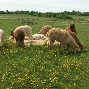
Alpakawanderungen, Hofladen Pferdehof Kornrade
Mönkhagen
Corinna-Fischer
@Corinna-Fischer
Bewegungstherapie für ADS-Kinder
Bewegungstrainer
Reitsportartikel
Beratung rund ums Pferd
Internetangebot
5 weitere...
P
Deprecated: Creation of dynamic property Zend_View_Helper_Ads::$adLink is deprecated in /var/www/stall-frei/htdocs/staging.stall-frei.de/library/Psf/View/Helper/Ads.php on line 108

Futtersack HeuToy, Fressbremse in pink
Mechtersen
STALL-FREIde Marketing
@STALL-FREI-Marketing
Stundenlange Beschäftigung die
Koliken vorbeugt, geringe Staubinhalation mit
steuerbarer Futterentnahme

Reitgeschäft Reiterlounge - Deckenwaschservice
Alt-Mölln
Reiterlounge
@reiter_lounge
Maßanfertigungen
Reitdeckenpflege
Ausstattung und Zubehör für den Stall
Beratung rund ums Pferd
1 weitere...
B+

Pferdeosteopathie und Pferdepysiotherapie
Lüdersdorf
Maria Wilhelms
@Balance4Horses
Pferdephysiotherapeut
Beratung rund ums Pferd
Akupressur
Andere Heilverfahren
10 weitere...
B+


Ausbildung Pferd und Reiter / begradigen Reitboden
Kükels
Winklers-Hof
@Winklers-Hof
Fahrsport
Longenarbeit
Beratung rund ums Pferd
Kutschfahrten
8 weitere...
P+


Bedampftes Heu - bzw. Lohnbedampfung
Kükels
Winklers-Hof
@Winklers-Hof
Futtermittel: Herstellung
Futtermittel: Lieferung oder Versand
Lohnunternehmen
P+

B+

Das Beste für die Hufe
Mechtersen
STALL-FREIde Marketing
@STALL-FREI-Marketing
Hufschmiede und Hufpfleger in Ihrer Nähe


Bemer Decke ausprobieren bei Ihnen im Stall,...
Witzhave
Kathanus Ranch Team
@Kathanus-Ranch
Tiermedizinische/r Fachangestellte/r
Magnetfeldtherapie
B+

Fahrpferde- u. Reitpferdeausbildung 760,-€ +
Kölzin
Nicole Dabbert
@F-Rothacker
Bodenarbeit
Fahrsport
Pferdevermittlung
Pferdetransport, Deutschland
Holzrückearbeiten mit dem Pferd
Kutschfahrten
3 weitere...
B+
Deprecated: Creation of dynamic property Zend_View::$pageCount is deprecated in /var/www/stall-frei/htdocs/staging.stall-frei.de/library/vendor/shardj/zf1-future/library/Zend/View/Abstract.php on line 308
Deprecated: Creation of dynamic property Zend_View::$itemCountPerPage is deprecated in /var/www/stall-frei/htdocs/staging.stall-frei.de/library/vendor/shardj/zf1-future/library/Zend/View/Abstract.php on line 308
Deprecated: Creation of dynamic property Zend_View::$first is deprecated in /var/www/stall-frei/htdocs/staging.stall-frei.de/library/vendor/shardj/zf1-future/library/Zend/View/Abstract.php on line 308
Deprecated: Creation of dynamic property Zend_View::$current is deprecated in /var/www/stall-frei/htdocs/staging.stall-frei.de/library/vendor/shardj/zf1-future/library/Zend/View/Abstract.php on line 308
Deprecated: Creation of dynamic property Zend_View::$last is deprecated in /var/www/stall-frei/htdocs/staging.stall-frei.de/library/vendor/shardj/zf1-future/library/Zend/View/Abstract.php on line 308
Deprecated: Creation of dynamic property Zend_View::$next is deprecated in /var/www/stall-frei/htdocs/staging.stall-frei.de/library/vendor/shardj/zf1-future/library/Zend/View/Abstract.php on line 308
Deprecated: Creation of dynamic property Zend_View::$pagesInRange is deprecated in /var/www/stall-frei/htdocs/staging.stall-frei.de/library/vendor/shardj/zf1-future/library/Zend/View/Abstract.php on line 308
Deprecated: Creation of dynamic property Zend_View::$firstPageInRange is deprecated in /var/www/stall-frei/htdocs/staging.stall-frei.de/library/vendor/shardj/zf1-future/library/Zend/View/Abstract.php on line 308
Deprecated: Creation of dynamic property Zend_View::$lastPageInRange is deprecated in /var/www/stall-frei/htdocs/staging.stall-frei.de/library/vendor/shardj/zf1-future/library/Zend/View/Abstract.php on line 308
Deprecated: Creation of dynamic property Zend_View::$currentItemCount is deprecated in /var/www/stall-frei/htdocs/staging.stall-frei.de/library/vendor/shardj/zf1-future/library/Zend/View/Abstract.php on line 308
Deprecated: Creation of dynamic property Zend_View::$totalItemCount is deprecated in /var/www/stall-frei/htdocs/staging.stall-frei.de/library/vendor/shardj/zf1-future/library/Zend/View/Abstract.php on line 308
Deprecated: Creation of dynamic property Zend_View::$firstItemNumber is deprecated in /var/www/stall-frei/htdocs/staging.stall-frei.de/library/vendor/shardj/zf1-future/library/Zend/View/Abstract.php on line 308
Deprecated: Creation of dynamic property Zend_View::$lastItemNumber is deprecated in /var/www/stall-frei/htdocs/staging.stall-frei.de/library/vendor/shardj/zf1-future/library/Zend/View/Abstract.php on line 308
Deprecated: Creation of dynamic property Zend_View::$router is deprecated in /var/www/stall-frei/htdocs/staging.stall-frei.de/library/vendor/shardj/zf1-future/library/Zend/View/Abstract.php on line 308
Deprecated: Creation of dynamic property Zend_View::$urlParams is deprecated in /var/www/stall-frei/htdocs/staging.stall-frei.de/library/vendor/shardj/zf1-future/library/Zend/View/Abstract.php on line 308
Deprecated: Creation of dynamic property Zend_View::$showAds is deprecated in /var/www/stall-frei/htdocs/staging.stall-frei.de/library/vendor/shardj/zf1-future/library/Zend/View/Abstract.php on line 308
Deprecated: Creation of dynamic property Zend_View::$objectIds is deprecated in /var/www/stall-frei/htdocs/staging.stall-frei.de/library/vendor/shardj/zf1-future/library/Zend/View/Abstract.php on line 308
Deprecated: Creation of dynamic property Zend_View::$showNavbar is deprecated in /var/www/stall-frei/htdocs/staging.stall-frei.de/library/vendor/shardj/zf1-future/library/Zend/View/Abstract.php on line 308
Deprecated: Creation of dynamic property Zend_View::$showBreadcrumb is deprecated in /var/www/stall-frei/htdocs/staging.stall-frei.de/library/vendor/shardj/zf1-future/library/Zend/View/Abstract.php on line 308
Deprecated: Creation of dynamic property Zend_View::$showFooter is deprecated in /var/www/stall-frei/htdocs/staging.stall-frei.de/library/vendor/shardj/zf1-future/library/Zend/View/Abstract.php on line 308
Deprecated: Creation of dynamic property Zend_View::$showInternalAds is deprecated in /var/www/stall-frei/htdocs/staging.stall-frei.de/library/vendor/shardj/zf1-future/library/Zend/View/Abstract.php on line 308
Deprecated: Creation of dynamic property Zend_View::$blNoContent is deprecated in /var/www/stall-frei/htdocs/staging.stall-frei.de/library/vendor/shardj/zf1-future/library/Zend/View/Abstract.php on line 308
Deprecated: Creation of dynamic property Zend_View::$sMetaDesc is deprecated in /var/www/stall-frei/htdocs/staging.stall-frei.de/library/vendor/shardj/zf1-future/library/Zend/View/Abstract.php on line 308
Deprecated: Creation of dynamic property Zend_View::$useGmaps is deprecated in /var/www/stall-frei/htdocs/staging.stall-frei.de/library/vendor/shardj/zf1-future/library/Zend/View/Abstract.php on line 308
Deprecated: Creation of dynamic property Zend_View::$touches is deprecated in /var/www/stall-frei/htdocs/staging.stall-frei.de/library/vendor/shardj/zf1-future/library/Zend/View/Abstract.php on line 308
Deprecated: Creation of dynamic property Zend_View::$oProject is deprecated in /var/www/stall-frei/htdocs/staging.stall-frei.de/library/vendor/shardj/zf1-future/library/Zend/View/Abstract.php on line 308
Deprecated: Creation of dynamic property Zend_View::$pageHeadline is deprecated in /var/www/stall-frei/htdocs/staging.stall-frei.de/library/vendor/shardj/zf1-future/library/Zend/View/Abstract.php on line 308
Deprecated: Creation of dynamic property Zend_View::$disableLocationField is deprecated in /var/www/stall-frei/htdocs/staging.stall-frei.de/library/vendor/shardj/zf1-future/library/Zend/View/Abstract.php on line 308
Deprecated: Creation of dynamic property Zend_View::$isSearch is deprecated in /var/www/stall-frei/htdocs/staging.stall-frei.de/library/vendor/shardj/zf1-future/library/Zend/View/Abstract.php on line 308
Deprecated: Creation of dynamic property Zend_View::$pageTitle is deprecated in /var/www/stall-frei/htdocs/staging.stall-frei.de/library/vendor/shardj/zf1-future/library/Zend/View/Abstract.php on line 308
Deprecated: Creation of dynamic property Psf_Form_Element_Text::$class is deprecated in /var/www/stall-frei/htdocs/staging.stall-frei.de/library/vendor/shardj/zf1-future/library/Zend/Form/Element.php on line 874
Deprecated: Creation of dynamic property Psf_Form_Element_Text::$size is deprecated in /var/www/stall-frei/htdocs/staging.stall-frei.de/library/vendor/shardj/zf1-future/library/Zend/Form/Element.php on line 874
Deprecated: Creation of dynamic property Psf_Form_Element_Text::$placeholder is deprecated in /var/www/stall-frei/htdocs/staging.stall-frei.de/library/vendor/shardj/zf1-future/library/Zend/Form/Element.php on line 874
Deprecated: Creation of dynamic property Psf_Form_Element_Hidden::$class is deprecated in /var/www/stall-frei/htdocs/staging.stall-frei.de/library/vendor/shardj/zf1-future/library/Zend/Form/Element.php on line 874
Deprecated: Creation of dynamic property Psf_Form_Element_Hidden::$class is deprecated in /var/www/stall-frei/htdocs/staging.stall-frei.de/library/vendor/shardj/zf1-future/library/Zend/Form/Element.php on line 874
Deprecated: Creation of dynamic property Psf_Form_Element_Hidden::$class is deprecated in /var/www/stall-frei/htdocs/staging.stall-frei.de/library/vendor/shardj/zf1-future/library/Zend/Form/Element.php on line 874
Deprecated: Creation of dynamic property Psf_Form_Element_Hidden::$class is deprecated in /var/www/stall-frei/htdocs/staging.stall-frei.de/library/vendor/shardj/zf1-future/library/Zend/Form/Element.php on line 874
Deprecated: Creation of dynamic property Psf_Form_Element_Select::$class is deprecated in /var/www/stall-frei/htdocs/staging.stall-frei.de/library/vendor/shardj/zf1-future/library/Zend/Form/Element.php on line 874
Deprecated: Creation of dynamic property Psf_Form_Element_Text::$class is deprecated in /var/www/stall-frei/htdocs/staging.stall-frei.de/library/vendor/shardj/zf1-future/library/Zend/Form/Element.php on line 874
Deprecated: Creation of dynamic property Psf_Form_Element_Checkbox::$label is deprecated in /var/www/stall-frei/htdocs/staging.stall-frei.de/library/vendor/shardj/zf1-future/library/Zend/Form/Element.php on line 874
Deprecated: Creation of dynamic property Zend_View::$sort is deprecated in /var/www/stall-frei/htdocs/staging.stall-frei.de/library/vendor/shardj/zf1-future/library/Zend/View/Abstract.php on line 308
Deprecated: Creation of dynamic property Zend_View::$searchLocation is deprecated in /var/www/stall-frei/htdocs/staging.stall-frei.de/library/vendor/shardj/zf1-future/library/Zend/View/Abstract.php on line 308
Deprecated: Creation of dynamic property Zend_View::$locationHint is deprecated in /var/www/stall-frei/htdocs/staging.stall-frei.de/library/vendor/shardj/zf1-future/library/Zend/View/Abstract.php on line 308
Psf_GeoCoder_Abstract::getLocation: Kästorf Get Location CachedOrLive
Psf_GeoCoder_Abstract::getCachedOrLive: Kästorf
Psf_GeoCoder_OpenCageData::makeApiRequest: response:
Array
(
[documentation] => https://opencagedata.com/api
[licenses] => Array
(
[0] => Array
(
[name] => see attribution guide
[url] => https://opencagedata.com/credits
)
)
[results] => Array
(
[0] => Array
(
[bounds] => Array
(
[northeast] => Array
(
[lat] => 53.7624921
[lng] => 10.5869946
)
[southwest] => Array
(
[lat] => 53.7279373
[lng] => 10.5409775
)
)
[components] => Array
(
[ISO_3166-1_alpha-2] => DE
[ISO_3166-1_alpha-3] => DEU
[ISO_3166-2] => Array
(
[0] => DE-SH
)
[_category] => place
[_normalized_city] => Kastorf
[_type] => village
[continent] => Europe
[country] => Deutschland
[country_code] => de
[county] => Kreis Herzogtum Lauenburg
[municipality] => Berkenthin
[political_union] => European Union
[state] => Schleswig-Holstein
[state_code] => SH
[village] => Kastorf
)
[confidence] => 7
[formatted] => Kastorf, Schleswig-Holstein, Deutschland
[geometry] => Array
(
[lat] => 53.7486179
[lng] => 10.5687338
)
)
[1] => Array
(
[bounds] => Array
(
[northeast] => Array
(
[lat] => 52.5472424
[lng] => 10.5491453
)
[southwest] => Array
(
[lat] => 52.5072424
[lng] => 10.5091453
)
)
[components] => Array
(
[ISO_3166-1_alpha-2] => DE
[ISO_3166-1_alpha-3] => DEU
[ISO_3166-2] => Array
(
[0] => DE-NI
)
[_category] => place
[_normalized_city] => Gifhorn
[_type] => village
[continent] => Europe
[country] => Deutschland
[country_code] => de
[county] => Landkreis Gifhorn
[political_union] => European Union
[postcode] => 38559
[state] => Niedersachsen
[state_code] => NI
[town] => Gifhorn
[village] => Kästorf
)
[confidence] => 7
[formatted] => 38559 Kästorf, Deutschland
[geometry] => Array
(
[lat] => 52.5272424
[lng] => 10.5291453
)
)
[2] => Array
(
[bounds] => Array
(
[northeast] => Array
(
[lat] => 52.4626166
[lng] => 10.7914767
)
[southwest] => Array
(
[lat] => 52.4389069
[lng] => 10.762896
)
)
[components] => Array
(
[ISO_3166-1_alpha-2] => DE
[ISO_3166-1_alpha-3] => DEU
[ISO_3166-2] => Array
(
[0] => DE-NI
)
[_category] => place
[_normalized_city] => Wolfsburg
[_type] => neighbourhood
[city] => Wolfsburg
[city_district] => Kästorf-Sandkamp
[continent] => Europe
[country] => Deutschland
[country_code] => de
[political_union] => European Union
[state] => Niedersachsen
[state_code] => NI
[suburb] => Kästorf
)
[confidence] => 7
[formatted] => Kästorf, Wolfsburg, Niedersachsen, Deutschland
[geometry] => Array
(
[lat] => 52.4457297
[lng] => 10.7792342
)
)
[3] => Array
(
[bounds] => Array
(
[northeast] => Array
(
[lat] => 53.2203768
[lng] => 11.5365784
)
[southwest] => Array
(
[lat] => 53.1803768
[lng] => 11.4965784
)
)
[components] => Array
(
[ISO_3166-1_alpha-2] => DE
[ISO_3166-1_alpha-3] => DEU
[ISO_3166-2] => Array
(
[0] => DE-MV
)
[_category] => place
[_normalized_city] => Milow
[_type] => hamlet
[continent] => Europe
[country] => Deutschland
[country_code] => de
[county] => Ludwigslust-Parchim
[hamlet] => Kastorf
[municipality] => Grabow
[political_union] => European Union
[postcode] => 19300
[state] => Mecklenburg-Vorpommern
[state_code] => MV
[village] => Milow
)
[confidence] => 7
[formatted] => Kastorf, 19300 Milow, Deutschland
[geometry] => Array
(
[lat] => 53.2003768
[lng] => 11.5165784
)
)
[4] => Array
(
[bounds] => Array
(
[northeast] => Array
(
[lat] => 53.6764772
[lng] => 13.0823751
)
[southwest] => Array
(
[lat] => 53.6364772
[lng] => 13.0423751
)
)
[components] => Array
(
[ISO_3166-1_alpha-2] => DE
[ISO_3166-1_alpha-3] => DEU
[ISO_3166-2] => Array
(
[0] => DE-MV
)
[_category] => place
[_normalized_city] => Knorrendorf
[_type] => hamlet
[continent] => Europe
[country] => Deutschland
[country_code] => de
[county] => Mecklenburgische Seenplatte
[hamlet] => Kastorf
[municipality] => Stavenhagen
[political_union] => European Union
[state] => Mecklenburg-Vorpommern
[state_code] => MV
[village] => Knorrendorf
)
[confidence] => 7
[formatted] => Kastorf, Knorrendorf, Mecklenburg-Vorpommern, Deutschland
[geometry] => Array
(
[lat] => 53.6564772
[lng] => 13.0623751
)
)
[5] => Array
(
[components] => Array
(
[ISO_3166-1_alpha-2] => FR
[ISO_3166-1_alpha-3] => FRA
[ISO_3166-2] => Array
(
[0] => FR-IDF
[1] => FR-91
)
[_category] => road
[_normalized_city] => Corbeil-Essonnes
[_type] => road
[city] => Corbeil-Essonnes
[continent] => Europe
[country] => France
[country_code] => fr
[county] => Essonne
[local_authority] => Communauté d'agglomération Grand Paris Sud Seine Essonne Sénart
[political_union] => European Union
[postcode] => 91100
[road] => Place des Castors
[state] => Île-de-France
[state_code] => IDF
)
[confidence] => 2
[formatted] => Place des Castors, 91100 Corbeil-Essonnes, France
[geometry] => Array
(
[lat] => 48.601722
[lng] => 2.47885
)
)
[6] => Array
(
[components] => Array
(
[ISO_3166-1_alpha-2] => FR
[ISO_3166-1_alpha-3] => FRA
[ISO_3166-2] => Array
(
[0] => FR-IDF
[1] => FR-93
)
[_category] => road
[_normalized_city] => Noisy-le-Grand
[_type] => road
[city] => Noisy-le-Grand
[continent] => Europe
[country] => France
[country_code] => fr
[county] => Seine-Saint-Denis
[local_authority] => Métropole du Grand Paris
[political_union] => European Union
[postcode] => 93160
[road] => Place des Castors
[state] => Île-de-France
[state_code] => IDF
)
[confidence] => 2
[formatted] => Place des Castors, 93160 Noisy-le-Grand, France
[geometry] => Array
(
[lat] => 48.824397
[lng] => 2.580971
)
)
[7] => Array
(
[components] => Array
(
[ISO_3166-1_alpha-2] => FR
[ISO_3166-1_alpha-3] => FRA
[ISO_3166-2] => Array
(
[0] => FR-PAC
[1] => FR-06
)
[_category] => road
[_normalized_city] => Grasse
[_type] => road
[city] => Grasse
[continent] => Europe
[country] => France
[country_code] => fr
[county] => Alpes-Maritimes
[local_authority] => Communauté d'agglomération du Pays de Grasse
[political_union] => European Union
[postcode] => 06130
[road] => Chemin des Castors
[state] => Provence-Alpes-Côte d'Azur
[state_code] => PAC
)
[confidence] => 2
[formatted] => Chemin des Castors, 06130 Grasse, France
[geometry] => Array
(
[lat] => 43.641187
[lng] => 6.932555
)
)
[8] => Array
(
[components] => Array
(
[ISO_3166-1_alpha-2] => FR
[ISO_3166-1_alpha-3] => FRA
[ISO_3166-2] => Array
(
[0] => FR-OCC
[1] => FR-31
)
[_category] => place
[_normalized_city] => Toulouse
[_type] => place
[city] => Toulouse
[continent] => Europe
[country] => France
[country_code] => fr
[county] => Haute-Garonne
[local_authority] => Toulouse Métropole
[place] => Chemin des Castors
[political_union] => European Union
[postcode] => 31200
[state] => Occitanie
[state_code] => OCC
)
[confidence] => 2
[formatted] => Chemin des Castors, 31200 Toulouse, France
[geometry] => Array
(
[lat] => 43.628145
[lng] => 1.427202
)
)
[9] => Array
(
[components] => Array
(
[ISO_3166-1_alpha-2] => FR
[ISO_3166-1_alpha-3] => FRA
[ISO_3166-2] => Array
(
[0] => FR-NAQ
[1] => FR-33
)
[_category] => road
[_normalized_city] => Le Barp
[_type] => road
[city] => Le Barp
[continent] => Europe
[country] => France
[country_code] => fr
[county] => Gironde
[local_authority] => Communauté de communes du Val de l'Eyre
[political_union] => European Union
[postcode] => 33114
[road] => Rue de Castor
[state] => Nouvelle-Aquitaine
[state_code] => NAQ
)
[confidence] => 2
[formatted] => Rue de Castor, 33114 Le Barp, France
[geometry] => Array
(
[lat] => 44.596676
[lng] => -0.768916
)
)
)
[status] => Array
(
[code] => 200
[message] => OK
)
[stay_informed] => Array
(
[blog] => https://blog.opencagedata.com
[mastodon] => https://en.osm.town/@opencage
)
[thanks] => For using an OpenCage API
[timestamp] => Array
(
[created_http] => Sun, 08 Feb 2026 08:53:10 GMT
[created_unix] => 1770540790
)
[total_results] => 10
)
Psf_GeoCoder_Abstract::convertLocationResult
{"documentation":"https:\/\/opencagedata.com\/api","licenses":[{"name":"see attribution guide","url":"https:\/\/opencagedata.com\/credits"}],"results":[{"bounds":{"northeast":{"lat":53.7624921,"lng":10.5869946},"southwest":{"lat":53.7279373,"lng":10.5409775}},"components":{"ISO_3166-1_alpha-2":"DE","ISO_3166-1_alpha-3":"DEU","ISO_3166-2":["DE-SH"],"_category":"place","_normalized_city":"Kastorf","_type":"village","continent":"Europe","country":"Deutschland","country_code":"de","county":"Kreis Herzogtum Lauenburg","municipality":"Berkenthin","political_union":"European Union","state":"Schleswig-Holstein","state_code":"SH","village":"Kastorf"},"confidence":7,"formatted":"Kastorf, Schleswig-Holstein, Deutschland","geometry":{"lat":53.7486179,"lng":10.5687338}},{"bounds":{"northeast":{"lat":52.5472424,"lng":10.5491453},"southwest":{"lat":52.5072424,"lng":10.5091453}},"components":{"ISO_3166-1_alpha-2":"DE","ISO_3166-1_alpha-3":"DEU","ISO_3166-2":["DE-NI"],"_category":"place","_normalized_city":"Gifhorn","_type":"village","continent":"Europe","country":"Deutschland","country_code":"de","county":"Landkreis Gifhorn","political_union":"European Union","postcode":"38559","state":"Niedersachsen","state_code":"NI","town":"Gifhorn","village":"K\u00e4storf"},"confidence":7,"formatted":"38559 K\u00e4storf, Deutschland","geometry":{"lat":52.5272424,"lng":10.5291453}},{"bounds":{"northeast":{"lat":52.4626166,"lng":10.7914767},"southwest":{"lat":52.4389069,"lng":10.762896}},"components":{"ISO_3166-1_alpha-2":"DE","ISO_3166-1_alpha-3":"DEU","ISO_3166-2":["DE-NI"],"_category":"place","_normalized_city":"Wolfsburg","_type":"neighbourhood","city":"Wolfsburg","city_district":"K\u00e4storf-Sandkamp","continent":"Europe","country":"Deutschland","country_code":"de","political_union":"European Union","state":"Niedersachsen","state_code":"NI","suburb":"K\u00e4storf"},"confidence":7,"formatted":"K\u00e4storf, Wolfsburg, Niedersachsen, Deutschland","geometry":{"lat":52.4457297,"lng":10.7792342}},{"bounds":{"northeast":{"lat":53.2203768,"lng":11.5365784},"southwest":{"lat":53.1803768,"lng":11.4965784}},"components":{"ISO_3166-1_alpha-2":"DE","ISO_3166-1_alpha-3":"DEU","ISO_3166-2":["DE-MV"],"_category":"place","_normalized_city":"Milow","_type":"hamlet","continent":"Europe","country":"Deutschland","country_code":"de","county":"Ludwigslust-Parchim","hamlet":"Kastorf","municipality":"Grabow","political_union":"European Union","postcode":"19300","state":"Mecklenburg-Vorpommern","state_code":"MV","village":"Milow"},"confidence":7,"formatted":"Kastorf, 19300 Milow, Deutschland","geometry":{"lat":53.2003768,"lng":11.5165784}},{"bounds":{"northeast":{"lat":53.6764772,"lng":13.0823751},"southwest":{"lat":53.6364772,"lng":13.0423751}},"components":{"ISO_3166-1_alpha-2":"DE","ISO_3166-1_alpha-3":"DEU","ISO_3166-2":["DE-MV"],"_category":"place","_normalized_city":"Knorrendorf","_type":"hamlet","continent":"Europe","country":"Deutschland","country_code":"de","county":"Mecklenburgische Seenplatte","hamlet":"Kastorf","municipality":"Stavenhagen","political_union":"European Union","state":"Mecklenburg-Vorpommern","state_code":"MV","village":"Knorrendorf"},"confidence":7,"formatted":"Kastorf, Knorrendorf, Mecklenburg-Vorpommern, Deutschland","geometry":{"lat":53.6564772,"lng":13.0623751}},{"components":{"ISO_3166-1_alpha-2":"FR","ISO_3166-1_alpha-3":"FRA","ISO_3166-2":["FR-IDF","FR-91"],"_category":"road","_normalized_city":"Corbeil-Essonnes","_type":"road","city":"Corbeil-Essonnes","continent":"Europe","country":"France","country_code":"fr","county":"Essonne","local_authority":"Communaut\u00e9 d'agglom\u00e9ration Grand Paris Sud Seine Essonne S\u00e9nart","political_union":"European Union","postcode":"91100","road":"Place des Castors","state":"\u00cele-de-France","state_code":"IDF"},"confidence":2,"formatted":"Place des Castors, 91100 Corbeil-Essonnes, France","geometry":{"lat":48.601722,"lng":2.47885}},{"components":{"ISO_3166-1_alpha-2":"FR","ISO_3166-1_alpha-3":"FRA","ISO_3166-2":["FR-IDF","FR-93"],"_category":"road","_normalized_city":"Noisy-le-Grand","_type":"road","city":"Noisy-le-Grand","continent":"Europe","country":"France","country_code":"fr","county":"Seine-Saint-Denis","local_authority":"M\u00e9tropole du Grand Paris","political_union":"European Union","postcode":"93160","road":"Place des Castors","state":"\u00cele-de-France","state_code":"IDF"},"confidence":2,"formatted":"Place des Castors, 93160 Noisy-le-Grand, France","geometry":{"lat":48.824397,"lng":2.580971}},{"components":{"ISO_3166-1_alpha-2":"FR","ISO_3166-1_alpha-3":"FRA","ISO_3166-2":["FR-PAC","FR-06"],"_category":"road","_normalized_city":"Grasse","_type":"road","city":"Grasse","continent":"Europe","country":"France","country_code":"fr","county":"Alpes-Maritimes","local_authority":"Communaut\u00e9 d'agglom\u00e9ration du Pays de Grasse","political_union":"European Union","postcode":"06130","road":"Chemin des Castors","state":"Provence-Alpes-C\u00f4te d'Azur","state_code":"PAC"},"confidence":2,"formatted":"Chemin des Castors, 06130 Grasse, France","geometry":{"lat":43.641187,"lng":6.932555}},{"components":{"ISO_3166-1_alpha-2":"FR","ISO_3166-1_alpha-3":"FRA","ISO_3166-2":["FR-OCC","FR-31"],"_category":"place","_normalized_city":"Toulouse","_type":"place","city":"Toulouse","continent":"Europe","country":"France","country_code":"fr","county":"Haute-Garonne","local_authority":"Toulouse M\u00e9tropole","place":"Chemin des Castors","political_union":"European Union","postcode":"31200","state":"Occitanie","state_code":"OCC"},"confidence":2,"formatted":"Chemin des Castors, 31200 Toulouse, France","geometry":{"lat":43.628145,"lng":1.427202}},{"components":{"ISO_3166-1_alpha-2":"FR","ISO_3166-1_alpha-3":"FRA","ISO_3166-2":["FR-NAQ","FR-33"],"_category":"road","_normalized_city":"Le Barp","_type":"road","city":"Le Barp","continent":"Europe","country":"France","country_code":"fr","county":"Gironde","local_authority":"Communaut\u00e9 de communes du Val de l'Eyre","political_union":"European Union","postcode":"33114","road":"Rue de Castor","state":"Nouvelle-Aquitaine","state_code":"NAQ"},"confidence":2,"formatted":"Rue de Castor, 33114 Le Barp, France","geometry":{"lat":44.596676,"lng":-0.768916}}],"status":{"code":200,"message":"OK"},"stay_informed":{"blog":"https:\/\/blog.opencagedata.com","mastodon":"https:\/\/en.osm.town\/@opencage"},"thanks":"For using an OpenCage API","timestamp":{"created_http":"Sun, 08 Feb 2026 08:53:10 GMT","created_unix":1770540790},"total_results":10}Array
(
[0] => stdClass Object
(
[bounds] => stdClass Object
(
[northeast] => stdClass Object
(
[lat] => 53.7624921
[lng] => 10.5869946
)
[southwest] => stdClass Object
(
[lat] => 53.7279373
[lng] => 10.5409775
)
)
[components] => stdClass Object
(
[ISO_3166-1_alpha-2] => DE
[ISO_3166-1_alpha-3] => DEU
[ISO_3166-2] => Array
(
[0] => DE-SH
)
[_category] => place
[_normalized_city] => Kastorf
[_type] => village
[continent] => Europe
[country] => Deutschland
[country_code] => de
[county] => Kreis Herzogtum Lauenburg
[municipality] => Berkenthin
[political_union] => European Union
[state] => Schleswig-Holstein
[state_code] => SH
[village] => Kastorf
)
[confidence] => 7
[formatted] => Kastorf, Schleswig-Holstein, Deutschland
[geometry] => stdClass Object
(
[lat] => 53.7486179
[lng] => 10.5687338
)
)
[1] => stdClass Object
(
[bounds] => stdClass Object
(
[northeast] => stdClass Object
(
[lat] => 52.5472424
[lng] => 10.5491453
)
[southwest] => stdClass Object
(
[lat] => 52.5072424
[lng] => 10.5091453
)
)
[components] => stdClass Object
(
[ISO_3166-1_alpha-2] => DE
[ISO_3166-1_alpha-3] => DEU
[ISO_3166-2] => Array
(
[0] => DE-NI
)
[_category] => place
[_normalized_city] => Gifhorn
[_type] => village
[continent] => Europe
[country] => Deutschland
[country_code] => de
[county] => Landkreis Gifhorn
[political_union] => European Union
[postcode] => 38559
[state] => Niedersachsen
[state_code] => NI
[town] => Gifhorn
[village] => Kästorf
)
[confidence] => 7
[formatted] => 38559 Kästorf, Deutschland
[geometry] => stdClass Object
(
[lat] => 52.5272424
[lng] => 10.5291453
)
)
[2] => stdClass Object
(
[bounds] => stdClass Object
(
[northeast] => stdClass Object
(
[lat] => 52.4626166
[lng] => 10.7914767
)
[southwest] => stdClass Object
(
[lat] => 52.4389069
[lng] => 10.762896
)
)
[components] => stdClass Object
(
[ISO_3166-1_alpha-2] => DE
[ISO_3166-1_alpha-3] => DEU
[ISO_3166-2] => Array
(
[0] => DE-NI
)
[_category] => place
[_normalized_city] => Wolfsburg
[_type] => neighbourhood
[city] => Wolfsburg
[city_district] => Kästorf-Sandkamp
[continent] => Europe
[country] => Deutschland
[country_code] => de
[political_union] => European Union
[state] => Niedersachsen
[state_code] => NI
[suburb] => Kästorf
)
[confidence] => 7
[formatted] => Kästorf, Wolfsburg, Niedersachsen, Deutschland
[geometry] => stdClass Object
(
[lat] => 52.4457297
[lng] => 10.7792342
)
)
[3] => stdClass Object
(
[bounds] => stdClass Object
(
[northeast] => stdClass Object
(
[lat] => 53.2203768
[lng] => 11.5365784
)
[southwest] => stdClass Object
(
[lat] => 53.1803768
[lng] => 11.4965784
)
)
[components] => stdClass Object
(
[ISO_3166-1_alpha-2] => DE
[ISO_3166-1_alpha-3] => DEU
[ISO_3166-2] => Array
(
[0] => DE-MV
)
[_category] => place
[_normalized_city] => Milow
[_type] => hamlet
[continent] => Europe
[country] => Deutschland
[country_code] => de
[county] => Ludwigslust-Parchim
[hamlet] => Kastorf
[municipality] => Grabow
[political_union] => European Union
[postcode] => 19300
[state] => Mecklenburg-Vorpommern
[state_code] => MV
[village] => Milow
)
[confidence] => 7
[formatted] => Kastorf, 19300 Milow, Deutschland
[geometry] => stdClass Object
(
[lat] => 53.2003768
[lng] => 11.5165784
)
)
[4] => stdClass Object
(
[bounds] => stdClass Object
(
[northeast] => stdClass Object
(
[lat] => 53.6764772
[lng] => 13.0823751
)
[southwest] => stdClass Object
(
[lat] => 53.6364772
[lng] => 13.0423751
)
)
[components] => stdClass Object
(
[ISO_3166-1_alpha-2] => DE
[ISO_3166-1_alpha-3] => DEU
[ISO_3166-2] => Array
(
[0] => DE-MV
)
[_category] => place
[_normalized_city] => Knorrendorf
[_type] => hamlet
[continent] => Europe
[country] => Deutschland
[country_code] => de
[county] => Mecklenburgische Seenplatte
[hamlet] => Kastorf
[municipality] => Stavenhagen
[political_union] => European Union
[state] => Mecklenburg-Vorpommern
[state_code] => MV
[village] => Knorrendorf
)
[confidence] => 7
[formatted] => Kastorf, Knorrendorf, Mecklenburg-Vorpommern, Deutschland
[geometry] => stdClass Object
(
[lat] => 53.6564772
[lng] => 13.0623751
)
)
[5] => stdClass Object
(
[components] => stdClass Object
(
[ISO_3166-1_alpha-2] => FR
[ISO_3166-1_alpha-3] => FRA
[ISO_3166-2] => Array
(
[0] => FR-IDF
[1] => FR-91
)
[_category] => road
[_normalized_city] => Corbeil-Essonnes
[_type] => road
[city] => Corbeil-Essonnes
[continent] => Europe
[country] => France
[country_code] => fr
[county] => Essonne
[local_authority] => Communauté d'agglomération Grand Paris Sud Seine Essonne Sénart
[political_union] => European Union
[postcode] => 91100
[road] => Place des Castors
[state] => Île-de-France
[state_code] => IDF
)
[confidence] => 2
[formatted] => Place des Castors, 91100 Corbeil-Essonnes, France
[geometry] => stdClass Object
(
[lat] => 48.601722
[lng] => 2.47885
)
)
[6] => stdClass Object
(
[components] => stdClass Object
(
[ISO_3166-1_alpha-2] => FR
[ISO_3166-1_alpha-3] => FRA
[ISO_3166-2] => Array
(
[0] => FR-IDF
[1] => FR-93
)
[_category] => road
[_normalized_city] => Noisy-le-Grand
[_type] => road
[city] => Noisy-le-Grand
[continent] => Europe
[country] => France
[country_code] => fr
[county] => Seine-Saint-Denis
[local_authority] => Métropole du Grand Paris
[political_union] => European Union
[postcode] => 93160
[road] => Place des Castors
[state] => Île-de-France
[state_code] => IDF
)
[confidence] => 2
[formatted] => Place des Castors, 93160 Noisy-le-Grand, France
[geometry] => stdClass Object
(
[lat] => 48.824397
[lng] => 2.580971
)
)
[7] => stdClass Object
(
[components] => stdClass Object
(
[ISO_3166-1_alpha-2] => FR
[ISO_3166-1_alpha-3] => FRA
[ISO_3166-2] => Array
(
[0] => FR-PAC
[1] => FR-06
)
[_category] => road
[_normalized_city] => Grasse
[_type] => road
[city] => Grasse
[continent] => Europe
[country] => France
[country_code] => fr
[county] => Alpes-Maritimes
[local_authority] => Communauté d'agglomération du Pays de Grasse
[political_union] => European Union
[postcode] => 06130
[road] => Chemin des Castors
[state] => Provence-Alpes-Côte d'Azur
[state_code] => PAC
)
[confidence] => 2
[formatted] => Chemin des Castors, 06130 Grasse, France
[geometry] => stdClass Object
(
[lat] => 43.641187
[lng] => 6.932555
)
)
[8] => stdClass Object
(
[components] => stdClass Object
(
[ISO_3166-1_alpha-2] => FR
[ISO_3166-1_alpha-3] => FRA
[ISO_3166-2] => Array
(
[0] => FR-OCC
[1] => FR-31
)
[_category] => place
[_normalized_city] => Toulouse
[_type] => place
[city] => Toulouse
[continent] => Europe
[country] => France
[country_code] => fr
[county] => Haute-Garonne
[local_authority] => Toulouse Métropole
[place] => Chemin des Castors
[political_union] => European Union
[postcode] => 31200
[state] => Occitanie
[state_code] => OCC
)
[confidence] => 2
[formatted] => Chemin des Castors, 31200 Toulouse, France
[geometry] => stdClass Object
(
[lat] => 43.628145
[lng] => 1.427202
)
)
[9] => stdClass Object
(
[components] => stdClass Object
(
[ISO_3166-1_alpha-2] => FR
[ISO_3166-1_alpha-3] => FRA
[ISO_3166-2] => Array
(
[0] => FR-NAQ
[1] => FR-33
)
[_category] => road
[_normalized_city] => Le Barp
[_type] => road
[city] => Le Barp
[continent] => Europe
[country] => France
[country_code] => fr
[county] => Gironde
[local_authority] => Communauté de communes du Val de l'Eyre
[political_union] => European Union
[postcode] => 33114
[road] => Rue de Castor
[state] => Nouvelle-Aquitaine
[state_code] => NAQ
)
[confidence] => 2
[formatted] => Rue de Castor, 33114 Le Barp, France
[geometry] => stdClass Object
(
[lat] => 44.596676
[lng] => -0.768916
)
)
)
Psf_GeoCoder_OpenCageData::getKeyMap: 0
stdClass Object
(
    [bounds] => stdClass Object
        (
            [northeast] => stdClass Object
                (
                    [lat] => 53.7624921
                    [lng] => 10.5869946
                )

            [southwest] => stdClass Object
                (
                    [lat] => 53.7279373
                    [lng] => 10.5409775
                )

        )

    [components] => stdClass Object
        (
            [ISO_3166-1_alpha-2] => DE
            [ISO_3166-1_alpha-3] => DEU
            [ISO_3166-2] => Array
                (
                    [0] => DE-SH
                )

            [_category] => place
            [_normalized_city] => Kastorf
            [_type] => village
            [continent] => Europe
            [country] => Deutschland
            [country_code] => de
            [county] => Kreis Herzogtum Lauenburg
            [municipality] => Berkenthin
            [political_union] => European Union
            [state] => Schleswig-Holstein
            [state_code] => SH
            [village] => Kastorf
        )

    [confidence] => 7
    [formatted] => Kastorf, Schleswig-Holstein, Deutschland
    [geometry] => stdClass Object
        (
            [lat] => 53.7486179
            [lng] => 10.5687338
        )

)
Psf_GeoCoder_OpenCageData::getCounty: Herzogtum Lauenburg
Psf_GeoCoder_OpenCageData::addMissingData REFETCH!
Array
(
    [address] => Kastorf, Schleswig-Holstein, Deutschland
    [type] => village
    [street] =>
    [city] => Kastorf
    [county] => Herzogtum Lauenburg
    [state] => Schleswig-Holstein
    [zip] =>
    [country] => Deutschland
    [suburb] =>
    [countrycode] => de
    [latitude] => 53.7486179
    [longitude] => 10.5687338
    [accuracy] => 1
    [confidence] => 7
    [bounds] => stdClass Object
        (
            [northeast] => stdClass Object
                (
                    [lat] => 53.7624921
                    [lng] => 10.5869946
                )

            [southwest] => stdClass Object
                (
                    [lat] => 53.7279373
                    [lng] => 10.5409775
                )

        )

)
reformat!
Array
(
    [address] => Kastorf, Schleswig-Holstein, Deutschland
    [type] => village
    [street] =>
    [city] => Kastorf
    [county] => Herzogtum Lauenburg
    [state] => Schleswig-Holstein
    [zip] =>
    [country] => Deutschland
    [suburb] =>
    [countrycode] => de
    [latitude] => 53.7486179
    [longitude] => 10.5687338
    [accuracy] => 1
    [confidence] => 7
    [bounds] => stdClass Object
        (
            [northeast] => stdClass Object
                (
                    [lat] => 53.7624921
                    [lng] => 10.5869946
                )

            [southwest] => stdClass Object
                (
                    [lat] => 53.7279373
                    [lng] => 10.5409775
                )

        )

    [place] => Kastorf, Schleswig-Holstein
    [hash] => ee93d20d4b39439f64df681864719966
)
Psf_GeoCoder_OpenCageData::getKeyMap: 1
stdClass Object
(
    [bounds] => stdClass Object
        (
            [northeast] => stdClass Object
                (
                    [lat] => 52.5472424
                    [lng] => 10.5491453
                )

            [southwest] => stdClass Object
                (
                    [lat] => 52.5072424
                    [lng] => 10.5091453
                )

        )

    [components] => stdClass Object
        (
            [ISO_3166-1_alpha-2] => DE
            [ISO_3166-1_alpha-3] => DEU
            [ISO_3166-2] => Array
                (
                    [0] => DE-NI
                )

            [_category] => place
            [_normalized_city] => Gifhorn
            [_type] => village
            [continent] => Europe
            [country] => Deutschland
            [country_code] => de
            [county] => Landkreis Gifhorn
            [political_union] => European Union
            [postcode] => 38559
            [state] => Niedersachsen
            [state_code] => NI
            [town] => Gifhorn
            [village] => Kästorf
        )

    [confidence] => 7
    [formatted] => 38559 Kästorf, Deutschland
    [geometry] => stdClass Object
        (
            [lat] => 52.5272424
            [lng] => 10.5291453
        )

)
Psf_GeoCoder_OpenCageData::getCounty: Gifhorn
Psf_GeoCoder_OpenCageData::addMissingData REFETCH!
Array
(
    [address] => 38559 Kästorf, Deutschland
    [type] => village
    [street] =>
    [city] => Gifhorn
    [county] => Gifhorn
    [state] => Niedersachsen
    [zip] => 38559
    [country] => Deutschland
    [suburb] =>
    [countrycode] => de
    [latitude] => 52.5272424
    [longitude] => 10.5291453
    [accuracy] => 1
    [confidence] => 7
    [bounds] => stdClass Object
        (
            [northeast] => stdClass Object
                (
                    [lat] => 52.5472424
                    [lng] => 10.5491453
                )

            [southwest] => stdClass Object
                (
                    [lat] => 52.5072424
                    [lng] => 10.5091453
                )

        )

)
reformat!
Array
(
    [address] => 38559 Gifhorn
    [type] => village
    [street] =>
    [city] => Gifhorn
    [county] => Gifhorn
    [state] => Niedersachsen
    [zip] => 38559
    [country] => Deutschland
    [suburb] =>
    [countrycode] => de
    [latitude] => 52.5272424
    [longitude] => 10.5291453
    [accuracy] => 1
    [confidence] => 7
    [bounds] => stdClass Object
        (
            [northeast] => stdClass Object
                (
                    [lat] => 52.5472424
                    [lng] => 10.5491453
                )

            [southwest] => stdClass Object
                (
                    [lat] => 52.5072424
                    [lng] => 10.5091453
                )

        )

    [place] => 38559 Gifhorn, Niedersachsen
    [hash] => 1a57f53fb4359de71cc3a086ef705ba0
)
Psf_GeoCoder_OpenCageData::getKeyMap: 2
stdClass Object
(
    [bounds] => stdClass Object
        (
            [northeast] => stdClass Object
                (
                    [lat] => 52.4626166
                    [lng] => 10.7914767
                )

            [southwest] => stdClass Object
                (
                    [lat] => 52.4389069
                    [lng] => 10.762896
                )

        )

    [components] => stdClass Object
        (
            [ISO_3166-1_alpha-2] => DE
            [ISO_3166-1_alpha-3] => DEU
            [ISO_3166-2] => Array
                (
                    [0] => DE-NI
                )

            [_category] => place
            [_normalized_city] => Wolfsburg
            [_type] => neighbourhood
            [city] => Wolfsburg
            [city_district] => Kästorf-Sandkamp
            [continent] => Europe
            [country] => Deutschland
            [country_code] => de
            [political_union] => European Union
            [state] => Niedersachsen
            [state_code] => NI
            [suburb] => Kästorf
        )

    [confidence] => 7
    [formatted] => Kästorf, Wolfsburg, Niedersachsen, Deutschland
    [geometry] => stdClass Object
        (
            [lat] => 52.4457297
            [lng] => 10.7792342
        )

)
Psf_GeoCoder_OpenCageData::getCounty: Wolfsburg
Psf_GeoCoder_OpenCageData::addMissingData REFETCH!
Array
(
    [address] => Kästorf, Wolfsburg, Niedersachsen, Deutschland
    [type] => neighbourhood
    [street] =>
    [city] => Kästorf
    [county] => Wolfsburg
    [state] => Niedersachsen
    [zip] =>
    [country] => Deutschland
    [suburb] => Kästorf
    [countrycode] => de
    [latitude] => 52.4457297
    [longitude] => 10.7792342
    [accuracy] => 1
    [confidence] => 7
    [bounds] => stdClass Object
        (
            [northeast] => stdClass Object
                (
                    [lat] => 52.4626166
                    [lng] => 10.7914767
                )

            [southwest] => stdClass Object
                (
                    [lat] => 52.4389069
                    [lng] => 10.762896
                )

        )

)
reformat!
Array
(
    [address] => Kästorf, Wolfsburg, Niedersachsen, Deutschland
    [type] => neighbourhood
    [street] =>
    [city] => Kästorf
    [county] => Wolfsburg
    [state] => Niedersachsen
    [zip] =>
    [country] => Deutschland
    [suburb] => Kästorf
    [countrycode] => de
    [latitude] => 52.4457297
    [longitude] => 10.7792342
    [accuracy] => 1
    [confidence] => 7
    [bounds] => stdClass Object
        (
            [northeast] => stdClass Object
                (
                    [lat] => 52.4626166
                    [lng] => 10.7914767
                )

            [southwest] => stdClass Object
                (
                    [lat] => 52.4389069
                    [lng] => 10.762896
                )

        )

    [place] => Kästorf, Niedersachsen
    [hash] => 1b350819526a36a1c7a864d9df659456
)
Psf_GeoCoder_OpenCageData::getKeyMap: 3
stdClass Object
(
    [bounds] => stdClass Object
        (
            [northeast] => stdClass Object
                (
                    [lat] => 53.2203768
                    [lng] => 11.5365784
                )

            [southwest] => stdClass Object
                (
                    [lat] => 53.1803768
                    [lng] => 11.4965784
                )

        )

    [components] => stdClass Object
        (
            [ISO_3166-1_alpha-2] => DE
            [ISO_3166-1_alpha-3] => DEU
            [ISO_3166-2] => Array
                (
                    [0] => DE-MV
                )

            [_category] => place
            [_normalized_city] => Milow
            [_type] => hamlet
            [continent] => Europe
            [country] => Deutschland
            [country_code] => de
            [county] => Ludwigslust-Parchim
            [hamlet] => Kastorf
            [municipality] => Grabow
            [political_union] => European Union
            [postcode] => 19300
            [state] => Mecklenburg-Vorpommern
            [state_code] => MV
            [village] => Milow
        )

    [confidence] => 7
    [formatted] => Kastorf, 19300 Milow, Deutschland
    [geometry] => stdClass Object
        (
            [lat] => 53.2003768
            [lng] => 11.5165784
        )

)
Psf_GeoCoder_OpenCageData::getCounty: Ludwigslust-Parchim
Psf_GeoCoder_OpenCageData::addMissingData REFETCH!
Array
(
    [address] => Kastorf, 19300 Milow, Deutschland
    [type] => hamlet
    [street] => Kastorf
    [city] => Milow
    [county] => Ludwigslust-Parchim
    [state] => Mecklenburg-Vorpommern
    [zip] => 19300
    [country] => Deutschland
    [suburb] =>
    [countrycode] => de
    [latitude] => 53.2003768
    [longitude] => 11.5165784
    [accuracy] => 1
    [confidence] => 7
    [bounds] => stdClass Object
        (
            [northeast] => stdClass Object
                (
                    [lat] => 53.2203768
                    [lng] => 11.5365784
                )

            [southwest] => stdClass Object
                (
                    [lat] => 53.1803768
                    [lng] => 11.4965784
                )

        )

)
reformat!
Array
(
    [address] => Kastorf, 19300 Milow, Deutschland
    [type] => hamlet
    [street] => Kastorf
    [city] => Milow
    [county] => Ludwigslust-Parchim
    [state] => Mecklenburg-Vorpommern
    [zip] => 19300
    [country] => Deutschland
    [suburb] =>
    [countrycode] => de
    [latitude] => 53.2003768
    [longitude] => 11.5165784
    [accuracy] => 1
    [confidence] => 7
    [bounds] => stdClass Object
        (
            [northeast] => stdClass Object
                (
                    [lat] => 53.2203768
                    [lng] => 11.5365784
                )

            [southwest] => stdClass Object
                (
                    [lat] => 53.1803768
                    [lng] => 11.4965784
                )

        )

    [place] => Kastorf, 19300 Milow, Mecklenburg-Vorpommern
    [hash] => 52ed1acb4b9d34400a75749a27e17a4f
)
Psf_GeoCoder_OpenCageData::getKeyMap: 4
stdClass Object
(
    [bounds] => stdClass Object
        (
            [northeast] => stdClass Object
                (
                    [lat] => 53.6764772
                    [lng] => 13.0823751
                )

            [southwest] => stdClass Object
                (
                    [lat] => 53.6364772
                    [lng] => 13.0423751
                )

        )

    [components] => stdClass Object
        (
            [ISO_3166-1_alpha-2] => DE
            [ISO_3166-1_alpha-3] => DEU
            [ISO_3166-2] => Array
                (
                    [0] => DE-MV
                )

            [_category] => place
            [_normalized_city] => Knorrendorf
            [_type] => hamlet
            [continent] => Europe
            [country] => Deutschland
            [country_code] => de
            [county] => Mecklenburgische Seenplatte
            [hamlet] => Kastorf
            [municipality] => Stavenhagen
            [political_union] => European Union
            [state] => Mecklenburg-Vorpommern
            [state_code] => MV
            [village] => Knorrendorf
        )

    [confidence] => 7
    [formatted] => Kastorf, Knorrendorf, Mecklenburg-Vorpommern, Deutschland
    [geometry] => stdClass Object
        (
            [lat] => 53.6564772
            [lng] => 13.0623751
        )

)
Psf_GeoCoder_OpenCageData::getCounty: Mecklenburgische Seenplatte
Psf_GeoCoder_OpenCageData::addMissingData REFETCH!
Array
(
    [address] => Kastorf, Knorrendorf, Mecklenburg-Vorpommern, Deutschland
    [type] => hamlet
    [street] => Kastorf
    [city] => Knorrendorf
    [county] => Mecklenburgische Seenplatte
    [state] => Mecklenburg-Vorpommern
    [zip] =>
    [country] => Deutschland
    [suburb] =>
    [countrycode] => de
    [latitude] => 53.6564772
    [longitude] => 13.0623751
    [accuracy] => 1
    [confidence] => 7
    [bounds] => stdClass Object
        (
            [northeast] => stdClass Object
                (
                    [lat] => 53.6764772
                    [lng] => 13.0823751
                )

            [southwest] => stdClass Object
                (
                    [lat] => 53.6364772
                    [lng] => 13.0423751
                )

        )

)
reformat!
Array
(
    [address] => Kastorf, Knorrendorf, Mecklenburg-Vorpommern, Deutschland
    [type] => hamlet
    [street] => Kastorf
    [city] => Knorrendorf
    [county] => Mecklenburgische Seenplatte
    [state] => Mecklenburg-Vorpommern
    [zip] =>
    [country] => Deutschland
    [suburb] =>
    [countrycode] => de
    [latitude] => 53.6564772
    [longitude] => 13.0623751
    [accuracy] => 1
    [confidence] => 7
    [bounds] => stdClass Object
        (
            [northeast] => stdClass Object
                (
                    [lat] => 53.6764772
                    [lng] => 13.0823751
                )

            [southwest] => stdClass Object
                (
                    [lat] => 53.6364772
                    [lng] => 13.0423751
                )

        )

    [place] => Kastorf, Knorrendorf, Mecklenburg-Vorpommern
    [hash] => 7ca58286515ecea25ec67cfc460ec4b5
)
Psf_GeoCoder_OpenCageData::getKeyMap: 5
stdClass Object
(
    [components] => stdClass Object
        (
            [ISO_3166-1_alpha-2] => FR
            [ISO_3166-1_alpha-3] => FRA
            [ISO_3166-2] => Array
                (
                    [0] => FR-IDF
                    [1] => FR-91
                )

            [_category] => road
            [_normalized_city] => Corbeil-Essonnes
            [_type] => road
            [city] => Corbeil-Essonnes
            [continent] => Europe
            [country] => France
            [country_code] => fr
            [county] => Essonne
            [local_authority] => Communauté d'agglomération Grand Paris Sud Seine Essonne Sénart
            [political_union] => European Union
            [postcode] => 91100
            [road] => Place des Castors
            [state] => Île-de-France
            [state_code] => IDF
        )

    [confidence] => 2
    [formatted] => Place des Castors, 91100 Corbeil-Essonnes, France
    [geometry] => stdClass Object
        (
            [lat] => 48.601722
            [lng] => 2.47885
        )

)
Psf_GeoCoder_OpenCageData::getCounty: Essonne
Psf_GeoCoder_OpenCageData::addMissingData REFETCH!
Array
(
    [address] => Place des Castors, 91100 Corbeil-Essonnes, France
    [type] => road
    [street] => Place des Castors
    [city] => Corbeil-Essonnes
    [county] => Essonne
    [state] => Île-de-France
    [zip] => 91100
    [country] => France
    [suburb] =>
    [countrycode] => fr
    [latitude] => 48.601722
    [longitude] => 2.47885
    [accuracy] => 1
    [confidence] => 2
    [bounds] =>
)
reformat!
Array
(
    [address] => Place des Castors, 91100 Corbeil-Essonnes, France
    [type] => road
    [street] => Place des Castors
    [city] => Corbeil-Essonnes
    [county] => Essonne
    [state] => Île-de-France
    [zip] => 91100
    [country] => France
    [suburb] =>
    [countrycode] => fr
    [latitude] => 48.601722
    [longitude] => 2.47885
    [accuracy] => 1
    [confidence] => 2
    [bounds] =>
    [place] => Place des Castors, 91100 Corbeil-Essonnes, Île-de-France
    [hash] => 5fc905d25e1304ed54e6ba1e35e3bede
)
Psf_GeoCoder_OpenCageData::getKeyMap: 6
stdClass Object
(
    [components] => stdClass Object
        (
            [ISO_3166-1_alpha-2] => FR
            [ISO_3166-1_alpha-3] => FRA
            [ISO_3166-2] => Array
                (
                    [0] => FR-IDF
                    [1] => FR-93
                )

            [_category] => road
            [_normalized_city] => Noisy-le-Grand
            [_type] => road
            [city] => Noisy-le-Grand
            [continent] => Europe
            [country] => France
            [country_code] => fr
            [county] => Seine-Saint-Denis
            [local_authority] => Métropole du Grand Paris
            [political_union] => European Union
            [postcode] => 93160
            [road] => Place des Castors
            [state] => Île-de-France
            [state_code] => IDF
        )

    [confidence] => 2
    [formatted] => Place des Castors, 93160 Noisy-le-Grand, France
    [geometry] => stdClass Object
        (
            [lat] => 48.824397
            [lng] => 2.580971
        )

)
Psf_GeoCoder_OpenCageData::getCounty: Seine-Saint-Denis
Psf_GeoCoder_OpenCageData::addMissingData REFETCH!
Array
(
    [address] => Place des Castors, 93160 Noisy-le-Grand, France
    [type] => road
    [street] => Place des Castors
    [city] => Noisy-le-Grand
    [county] => Seine-Saint-Denis
    [state] => Île-de-France
    [zip] => 93160
    [country] => France
    [suburb] =>
    [countrycode] => fr
    [latitude] => 48.824397
    [longitude] => 2.580971
    [accuracy] => 1
    [confidence] => 2
    [bounds] =>
)
reformat!
Array
(
    [address] => Place des Castors, 93160 Noisy-le-Grand, France
    [type] => road
    [street] => Place des Castors
    [city] => Noisy-le-Grand
    [county] => Seine-Saint-Denis
    [state] => Île-de-France
    [zip] => 93160
    [country] => France
    [suburb] =>
    [countrycode] => fr
    [latitude] => 48.824397
    [longitude] => 2.580971
    [accuracy] => 1
    [confidence] => 2
    [bounds] =>
    [place] => Place des Castors, 93160 Noisy-le-Grand, Île-de-France
    [hash] => 9f6ba08c638097ff58f55804fd4ca0a6
)
Psf_GeoCoder_OpenCageData::getKeyMap: 7
stdClass Object
(
    [components] => stdClass Object
        (
            [ISO_3166-1_alpha-2] => FR
            [ISO_3166-1_alpha-3] => FRA
            [ISO_3166-2] => Array
                (
                    [0] => FR-PAC
                    [1] => FR-06
                )

            [_category] => road
            [_normalized_city] => Grasse
            [_type] => road
            [city] => Grasse
            [continent] => Europe
            [country] => France
            [country_code] => fr
            [county] => Alpes-Maritimes
            [local_authority] => Communauté d'agglomération du Pays de Grasse
            [political_union] => European Union
            [postcode] => 06130
            [road] => Chemin des Castors
            [state] => Provence-Alpes-Côte d'Azur
            [state_code] => PAC
        )

    [confidence] => 2
    [formatted] => Chemin des Castors, 06130 Grasse, France
    [geometry] => stdClass Object
        (
            [lat] => 43.641187
            [lng] => 6.932555
        )

)
Psf_GeoCoder_OpenCageData::getCounty: Alpes-Maritimes
Psf_GeoCoder_OpenCageData::addMissingData REFETCH!
Array
(
    [address] => Chemin des Castors, 06130 Grasse, France
    [type] => road
    [street] => Chemin des Castors
    [city] => Grasse
    [county] => Alpes-Maritimes
    [state] => Provence-Alpes-Côte d'Azur
    [zip] => 06130
    [country] => France
    [suburb] =>
    [countrycode] => fr
    [latitude] => 43.641187
    [longitude] => 6.932555
    [accuracy] => 1
    [confidence] => 2
    [bounds] =>
)
reformat!
Array
(
    [address] => Chemin des Castors, 06130 Grasse, France
    [type] => road
    [street] => Chemin des Castors
    [city] => Grasse
    [county] => Alpes-Maritimes
    [state] => Provence-Alpes-Côte d'Azur
    [zip] => 06130
    [country] => France
    [suburb] =>
    [countrycode] => fr
    [latitude] => 43.641187
    [longitude] => 6.932555
    [accuracy] => 1
    [confidence] => 2
    [bounds] =>
    [place] => Chemin des Castors, 06130 Grasse, Provence-Alpes-Côte d'Azur
    [hash] => 916d86fff3126a0479f1b44f6f0a0282
)
Psf_GeoCoder_OpenCageData::getKeyMap: 8
stdClass Object
(
    [components] => stdClass Object
        (
            [ISO_3166-1_alpha-2] => FR
            [ISO_3166-1_alpha-3] => FRA
            [ISO_3166-2] => Array
                (
                    [0] => FR-OCC
                    [1] => FR-31
                )

            [_category] => place
            [_normalized_city] => Toulouse
            [_type] => place
            [city] => Toulouse
            [continent] => Europe
            [country] => France
            [country_code] => fr
            [county] => Haute-Garonne
            [local_authority] => Toulouse Métropole
            [place] => Chemin des Castors
            [political_union] => European Union
            [postcode] => 31200
            [state] => Occitanie
            [state_code] => OCC
        )

    [confidence] => 2
    [formatted] => Chemin des Castors, 31200 Toulouse, France
    [geometry] => stdClass Object
        (
            [lat] => 43.628145
            [lng] => 1.427202
        )

)
Psf_GeoCoder_OpenCageData::getCounty: Haute-Garonne
Psf_GeoCoder_OpenCageData::addMissingData REFETCH!
Array
(
    [address] => Chemin des Castors, 31200 Toulouse, France
    [type] => place
    [street] =>
    [city] => Toulouse
    [county] => Haute-Garonne
    [state] => Occitanie
    [zip] => 31200
    [country] => France
    [suburb] =>
    [countrycode] => fr
    [latitude] => 43.628145
    [longitude] => 1.427202
    [accuracy] => 1
    [confidence] => 2
    [bounds] =>
)
reformat!
Array
(
    [address] => Chemin des Castors, 31200 Toulouse, France
    [type] => place
    [street] =>
    [city] => Toulouse
    [county] => Haute-Garonne
    [state] => Occitanie
    [zip] => 31200
    [country] => France
    [suburb] =>
    [countrycode] => fr
    [latitude] => 43.628145
    [longitude] => 1.427202
    [accuracy] => 1
    [confidence] => 2
    [bounds] =>
    [place] => 31200 Toulouse, Occitanie
    [hash] => 9cd1b5dad013944f5aab01ea7b97a61f
)
Psf_GeoCoder_OpenCageData::getKeyMap: 9
stdClass Object
(
    [components] => stdClass Object
        (
            [ISO_3166-1_alpha-2] => FR
            [ISO_3166-1_alpha-3] => FRA
            [ISO_3166-2] => Array
                (
                    [0] => FR-NAQ
                    [1] => FR-33
                )

            [_category] => road
            [_normalized_city] => Le Barp
            [_type] => road
            [city] => Le Barp
            [continent] => Europe
            [country] => France
            [country_code] => fr
            [county] => Gironde
            [local_authority] => Communauté de communes du Val de l'Eyre
            [political_union] => European Union
            [postcode] => 33114
            [road] => Rue de Castor
            [state] => Nouvelle-Aquitaine
            [state_code] => NAQ
        )

    [confidence] => 2
    [formatted] => Rue de Castor, 33114 Le Barp, France
    [geometry] => stdClass Object
        (
            [lat] => 44.596676
            [lng] => -0.768916
        )

)
Psf_GeoCoder_OpenCageData::getCounty: Gironde
Psf_GeoCoder_OpenCageData::addMissingData REFETCH!
Array
(
    [address] => Rue de Castor, 33114 Le Barp, France
    [type] => road
    [street] => Rue de Castor
    [city] => Le Barp
    [county] => Gironde
    [state] => Nouvelle-Aquitaine
    [zip] => 33114
    [country] => France
    [suburb] =>
    [countrycode] => fr
    [latitude] => 44.596676
    [longitude] => -0.768916
    [accuracy] => 1
    [confidence] => 2
    [bounds] =>
)
reformat!
Array
(
    [address] => Rue de Castor, 33114 Le Barp, France
    [type] => road
    [street] => Rue de Castor
    [city] => Le Barp
    [county] => Gironde
    [state] => Nouvelle-Aquitaine
    [zip] => 33114
    [country] => France
    [suburb] =>
    [countrycode] => fr
    [latitude] => 44.596676
    [longitude] => -0.768916
    [accuracy] => 1
    [confidence] => 2
    [bounds] =>
    [place] => Rue de Castor, 33114 Le Barp, Nouvelle-Aquitaine
    [hash] => 43f359f5797849d28c750f6660516f87
)
Deprecated: Creation of dynamic property Zend_View::$locationHintStyle is deprecated in /var/www/stall-frei/htdocs/staging.stall-frei.de/library/vendor/shardj/zf1-future/library/Zend/View/Abstract.php on line 308
Deprecated: Creation of dynamic property Zend_View::$adGeoLocation is deprecated in /var/www/stall-frei/htdocs/staging.stall-frei.de/library/vendor/shardj/zf1-future/library/Zend/View/Abstract.php on line 308
Deprecated: Creation of dynamic property Zend_View::$recordCount is deprecated in /var/www/stall-frei/htdocs/staging.stall-frei.de/library/vendor/shardj/zf1-future/library/Zend/View/Abstract.php on line 308
Deprecated: explode(): Passing null to parameter #2 ($string) of type string is deprecated in /var/www/stall-frei/htdocs/staging.stall-frei.de/application/models/SearchAgent.php on line 100
Deprecated: explode(): Passing null to parameter #2 ($string) of type string is deprecated in /var/www/stall-frei/htdocs/staging.stall-frei.de/application/models/SearchAgent.php on line 100
Deprecated: explode(): Passing null to parameter #2 ($string) of type string is deprecated in /var/www/stall-frei/htdocs/staging.stall-frei.de/application/models/SearchAgent.php on line 100
Deprecated: explode(): Passing null to parameter #2 ($string) of type string is deprecated in /var/www/stall-frei/htdocs/staging.stall-frei.de/application/models/SearchAgent.php on line 100
Deprecated: explode(): Passing null to parameter #2 ($string) of type string is deprecated in /var/www/stall-frei/htdocs/staging.stall-frei.de/application/models/SearchAgent.php on line 100
Deprecated: explode(): Passing null to parameter #2 ($string) of type string is deprecated in /var/www/stall-frei/htdocs/staging.stall-frei.de/application/models/SearchAgent.php on line 100
Deprecated: explode(): Passing null to parameter #2 ($string) of type string is deprecated in /var/www/stall-frei/htdocs/staging.stall-frei.de/application/models/SearchAgent.php on line 100
Deprecated: explode(): Passing null to parameter #2 ($string) of type string is deprecated in /var/www/stall-frei/htdocs/staging.stall-frei.de/application/models/SearchAgent.php on line 100
Deprecated: trim(): Passing null to parameter #1 ($string) of type string is deprecated in /var/www/stall-frei/htdocs/staging.stall-frei.de/application/models/Account/Search.php on line 82
Warning: Cannot modify header information - headers already sent by (output started at /var/www/stall-frei/htdocs/staging.stall-frei.de/library/vendor/shardj/zf1-future/library/Zend/View/Abstract.php:308) in /var/www/stall-frei/htdocs/staging.stall-frei.de/application/models/Account/Search.php on line 71
Deprecated: Creation of dynamic property Zend_View::$paginationParams is deprecated in /var/www/stall-frei/htdocs/staging.stall-frei.de/library/vendor/shardj/zf1-future/library/Zend/View/Abstract.php on line 308
Deprecated: Creation of dynamic property Zend_View::$objectPaginator is deprecated in /var/www/stall-frei/htdocs/staging.stall-frei.de/library/vendor/shardj/zf1-future/library/Zend/View/Abstract.php on line 308
Deprecated: Creation of dynamic property Zend_View::$featuredObjects is deprecated in /var/www/stall-frei/htdocs/staging.stall-frei.de/library/vendor/shardj/zf1-future/library/Zend/View/Abstract.php on line 308
Deprecated: Creation of dynamic property Zend_View::$hints is deprecated in /var/www/stall-frei/htdocs/staging.stall-frei.de/library/vendor/shardj/zf1-future/library/Zend/View/Abstract.php on line 308
Deprecated: Creation of dynamic property Zend_View::$attributeHints is deprecated in /var/www/stall-frei/htdocs/staging.stall-frei.de/library/vendor/shardj/zf1-future/library/Zend/View/Abstract.php on line 308
Deprecated: Creation of dynamic property Zend_View::$oSearchForm is deprecated in /var/www/stall-frei/htdocs/staging.stall-frei.de/library/vendor/shardj/zf1-future/library/Zend/View/Abstract.php on line 308