Deprecated: Creation of dynamic property Zend_View::$sMode is deprecated in /var/www/stall-frei/htdocs/staging.stall-frei.de/library/vendor/shardj/zf1-future/library/Zend/View/Abstract.php on line 308
Stallplatz oder Offenstall in Soden
Gesucht wird in "63834 Soden, Deutschland"
6.330 Einträge
Deprecated: Creation of dynamic property Zend_View::$listObjects is deprecated in /var/www/stall-frei/htdocs/staging.stall-frei.de/library/vendor/shardj/zf1-future/library/Zend/View/Abstract.php on line 308
Gesponsort


Deprecated: Creation of dynamic property Zend_View::$listMode is deprecated in /var/www/stall-frei/htdocs/staging.stall-frei.de/library/vendor/shardj/zf1-future/library/Zend/View/Abstract.php on line 308
Deprecated: Creation of dynamic property Zend_View::$renderedObjects is deprecated in /var/www/stall-frei/htdocs/staging.stall-frei.de/library/vendor/shardj/zf1-future/library/Zend/View/Abstract.php on line 308
Deprecated: Creation of dynamic property Zend_View::$index is deprecated in /var/www/stall-frei/htdocs/staging.stall-frei.de/library/vendor/shardj/zf1-future/library/Zend/View/Abstract.php on line 308
Deprecated: Creation of dynamic property Zend_View::$displayMode is deprecated in /var/www/stall-frei/htdocs/staging.stall-frei.de/library/vendor/shardj/zf1-future/library/Zend/View/Abstract.php on line 308
Deprecated: Creation of dynamic property Zend_View::$remarketingIds is deprecated in /var/www/stall-frei/htdocs/staging.stall-frei.de/library/vendor/shardj/zf1-future/library/Zend/View/Abstract.php on line 308
Deprecated: Creation of dynamic property Zend_View::$listItem is deprecated in /var/www/stall-frei/htdocs/staging.stall-frei.de/library/vendor/shardj/zf1-future/library/Zend/View/Abstract.php on line 308
Deprecated: Creation of dynamic property Zend_View::$object is deprecated in /var/www/stall-frei/htdocs/staging.stall-frei.de/library/vendor/shardj/zf1-future/library/Zend/View/Abstract.php on line 308
Deprecated: Creation of dynamic property Zend_View::$attributes is deprecated in /var/www/stall-frei/htdocs/staging.stall-frei.de/library/vendor/shardj/zf1-future/library/Zend/View/Abstract.php on line 308
Leider kein Vorschaubild
Leider kein Vorschaubild
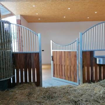
Box auf Reitanlage fei !!!
Aschaffenburg
Fleckenstein
@Fleckenstein
FN-Mitglied
Freizeitstall
Vermieten
Hunde willkommen
Krankenbox
bedampftes/gewaschenes Heu
Hengsthaltung möglich
32 weitere...
B

Frohmader Pferdepension
Babenhausen
Julia Frohmader Pferdepension
@Julia-Frohmader
Freizeitstall
Vermieten
Verpachten
Hunde willkommen
Krankenbox
Hufrehe geeignet
Notfallboxen
20 weitere...
P
Deprecated: Creation of dynamic property Zend_View_Helper_Ads::$adLink is deprecated in /var/www/stall-frei/htdocs/staging.stall-frei.de/library/Psf/View/Helper/Ads.php on line 108

Mitarbeiter gesucht?
Mechtersen
STALL-FREIde Marketing
@STALL-FREI-Marketing
Stellenangebote kostenlos veröffentlichen!
Richter Pferdesport
Babenhausen
Eva Richter
@ERichter
Fahrstall, Kutschwagen
Freizeitstall
Vermieten
Verpachten
Hunde willkommen
Krankenbox
Allergikerstall
Hufrehe geeignet
30 weitere...
P
Leider kein Vorschaubild
Leider kein Vorschaubild
Kl. Offenstall hat Platz für lieben Pony-Wallach
Mömlingen
E. Messing
@esther-messing
Freizeitstall
Reitlehrer und -unterricht
Vermieten
Hunde willkommen
Longierzirkel/Roundpen
Offenstall
10 weitere...
B
Leider kein Vorschaubild
Leider kein Vorschaubild
Full-Service Boxen mit Außenpaddock
Mömlingen
Reitzentrum Hasenberg 63853
@RGBZ
Pferdeausbildung
Rehabilitationsstall
Hunde willkommen
Laufband
Allergikerstall
bedampftes/gewaschenes Heu
Innenbox
18 weitere...
B

Heu und Heulage verkaufen
Mechtersen
STALL-FREIde Marketing
@STALL-FREI-Marketing
Verkaufen Sie Ihr Heu und Ihre Heulage direkt an Reiter, Pferdeställe und Reitanlagen

LAG-Offenstall mit Trail und Reithalle
Groß-Umstadt OT Raibach
Silke Buchner
@Silke_Buchner
Freizeitstall
VFD-Mitglied
Vermieten
Hunde willkommen
Krankenbox
Hengsthaltung möglich
Notfallboxen
17 weitere...
P
Leider kein Vorschaubild
Leider kein Vorschaubild
Offenstallplatz in kleiner Herde
Erlenbach am Main
Helen Balles
@HBalles
Freizeitstall
Geländestrecke
Vermieten
Verpachten
Hunde willkommen
Krankenbox
Hufrehe geeignet
Notfallboxen
18 weitere...
B


Pferdeboxen zu vermieten
Otzberg-Habitzheim
Katja Walter
@KatjaWalter
Freizeitstall
Vermieten
Longierzirkel/Roundpen
Paddock
Außenboxen
Innenbox
9 weitere...
P+
Leider kein Vorschaubild
Leider kein Vorschaubild
Stutfohlenplatz in artgerechter Aufzucht
Mönchberg
Spessartreiter
@Spessartreiter
FN-Mitglied
Freizeitstall
Vermieten
Hunde willkommen
Krankenbox
Allergikerstall
bedampftes/gewaschenes Heu
32 weitere...
B
Leider kein Vorschaubild
Leider kein Vorschaubild
Aktivpaddock Spessart 7* LAG/Allergiker/Reha
Mönchberg
Spessartreiter
@Spessartreiter
FN-Mitglied
Freizeitstall
Vermieten
Krankenbox
Longierzirkel/Roundpen
Allergikerstall
bedampftes/gewaschenes Heu
37 weitere...
B
Werde Teil von STALL-FREI.de
Du hast eine Pferdebox frei? Freie Plätze im Offenstall, Pferdestall oder der Reitanlage kostenlos anbieten.
Deprecated: Creation of dynamic property Zend_View::$pageCount is deprecated in /var/www/stall-frei/htdocs/staging.stall-frei.de/library/vendor/shardj/zf1-future/library/Zend/View/Abstract.php on line 308
Deprecated: Creation of dynamic property Zend_View::$itemCountPerPage is deprecated in /var/www/stall-frei/htdocs/staging.stall-frei.de/library/vendor/shardj/zf1-future/library/Zend/View/Abstract.php on line 308
Deprecated: Creation of dynamic property Zend_View::$first is deprecated in /var/www/stall-frei/htdocs/staging.stall-frei.de/library/vendor/shardj/zf1-future/library/Zend/View/Abstract.php on line 308
Deprecated: Creation of dynamic property Zend_View::$current is deprecated in /var/www/stall-frei/htdocs/staging.stall-frei.de/library/vendor/shardj/zf1-future/library/Zend/View/Abstract.php on line 308
Deprecated: Creation of dynamic property Zend_View::$last is deprecated in /var/www/stall-frei/htdocs/staging.stall-frei.de/library/vendor/shardj/zf1-future/library/Zend/View/Abstract.php on line 308
Deprecated: Creation of dynamic property Zend_View::$previous is deprecated in /var/www/stall-frei/htdocs/staging.stall-frei.de/library/vendor/shardj/zf1-future/library/Zend/View/Abstract.php on line 308
Deprecated: Creation of dynamic property Zend_View::$next is deprecated in /var/www/stall-frei/htdocs/staging.stall-frei.de/library/vendor/shardj/zf1-future/library/Zend/View/Abstract.php on line 308
Deprecated: Creation of dynamic property Zend_View::$pagesInRange is deprecated in /var/www/stall-frei/htdocs/staging.stall-frei.de/library/vendor/shardj/zf1-future/library/Zend/View/Abstract.php on line 308
Deprecated: Creation of dynamic property Zend_View::$firstPageInRange is deprecated in /var/www/stall-frei/htdocs/staging.stall-frei.de/library/vendor/shardj/zf1-future/library/Zend/View/Abstract.php on line 308
Deprecated: Creation of dynamic property Zend_View::$lastPageInRange is deprecated in /var/www/stall-frei/htdocs/staging.stall-frei.de/library/vendor/shardj/zf1-future/library/Zend/View/Abstract.php on line 308
Deprecated: Creation of dynamic property Zend_View::$currentItemCount is deprecated in /var/www/stall-frei/htdocs/staging.stall-frei.de/library/vendor/shardj/zf1-future/library/Zend/View/Abstract.php on line 308
Deprecated: Creation of dynamic property Zend_View::$totalItemCount is deprecated in /var/www/stall-frei/htdocs/staging.stall-frei.de/library/vendor/shardj/zf1-future/library/Zend/View/Abstract.php on line 308
Deprecated: Creation of dynamic property Zend_View::$firstItemNumber is deprecated in /var/www/stall-frei/htdocs/staging.stall-frei.de/library/vendor/shardj/zf1-future/library/Zend/View/Abstract.php on line 308
Deprecated: Creation of dynamic property Zend_View::$lastItemNumber is deprecated in /var/www/stall-frei/htdocs/staging.stall-frei.de/library/vendor/shardj/zf1-future/library/Zend/View/Abstract.php on line 308
Deprecated: Creation of dynamic property Zend_View::$router is deprecated in /var/www/stall-frei/htdocs/staging.stall-frei.de/library/vendor/shardj/zf1-future/library/Zend/View/Abstract.php on line 308
Deprecated: Creation of dynamic property Zend_View::$urlParams is deprecated in /var/www/stall-frei/htdocs/staging.stall-frei.de/library/vendor/shardj/zf1-future/library/Zend/View/Abstract.php on line 308
Deprecated: Creation of dynamic property Zend_View::$showAds is deprecated in /var/www/stall-frei/htdocs/staging.stall-frei.de/library/vendor/shardj/zf1-future/library/Zend/View/Abstract.php on line 308
Deprecated: Creation of dynamic property Zend_View::$objectIds is deprecated in /var/www/stall-frei/htdocs/staging.stall-frei.de/library/vendor/shardj/zf1-future/library/Zend/View/Abstract.php on line 308
Deprecated: Creation of dynamic property Zend_View::$showNavbar is deprecated in /var/www/stall-frei/htdocs/staging.stall-frei.de/library/vendor/shardj/zf1-future/library/Zend/View/Abstract.php on line 308
Deprecated: Creation of dynamic property Zend_View::$showBreadcrumb is deprecated in /var/www/stall-frei/htdocs/staging.stall-frei.de/library/vendor/shardj/zf1-future/library/Zend/View/Abstract.php on line 308
Deprecated: Creation of dynamic property Zend_View::$showFooter is deprecated in /var/www/stall-frei/htdocs/staging.stall-frei.de/library/vendor/shardj/zf1-future/library/Zend/View/Abstract.php on line 308
Deprecated: Creation of dynamic property Zend_View::$showInternalAds is deprecated in /var/www/stall-frei/htdocs/staging.stall-frei.de/library/vendor/shardj/zf1-future/library/Zend/View/Abstract.php on line 308
Deprecated: Creation of dynamic property Zend_View::$blNoContent is deprecated in /var/www/stall-frei/htdocs/staging.stall-frei.de/library/vendor/shardj/zf1-future/library/Zend/View/Abstract.php on line 308
Deprecated: Creation of dynamic property Zend_View::$sMetaDesc is deprecated in /var/www/stall-frei/htdocs/staging.stall-frei.de/library/vendor/shardj/zf1-future/library/Zend/View/Abstract.php on line 308
Deprecated: Creation of dynamic property Zend_View::$useGmaps is deprecated in /var/www/stall-frei/htdocs/staging.stall-frei.de/library/vendor/shardj/zf1-future/library/Zend/View/Abstract.php on line 308
Deprecated: Creation of dynamic property Zend_View::$touches is deprecated in /var/www/stall-frei/htdocs/staging.stall-frei.de/library/vendor/shardj/zf1-future/library/Zend/View/Abstract.php on line 308
Deprecated: Creation of dynamic property Zend_View::$oProject is deprecated in /var/www/stall-frei/htdocs/staging.stall-frei.de/library/vendor/shardj/zf1-future/library/Zend/View/Abstract.php on line 308
Deprecated: Creation of dynamic property Zend_View::$pageHeadline is deprecated in /var/www/stall-frei/htdocs/staging.stall-frei.de/library/vendor/shardj/zf1-future/library/Zend/View/Abstract.php on line 308
Deprecated: Creation of dynamic property Zend_View::$disableLocationField is deprecated in /var/www/stall-frei/htdocs/staging.stall-frei.de/library/vendor/shardj/zf1-future/library/Zend/View/Abstract.php on line 308
Deprecated: Creation of dynamic property Zend_View::$isSearch is deprecated in /var/www/stall-frei/htdocs/staging.stall-frei.de/library/vendor/shardj/zf1-future/library/Zend/View/Abstract.php on line 308
Deprecated: Creation of dynamic property Zend_View::$pageTitle is deprecated in /var/www/stall-frei/htdocs/staging.stall-frei.de/library/vendor/shardj/zf1-future/library/Zend/View/Abstract.php on line 308
Deprecated: Creation of dynamic property Psf_Form_Element_Text::$class is deprecated in /var/www/stall-frei/htdocs/staging.stall-frei.de/library/vendor/shardj/zf1-future/library/Zend/Form/Element.php on line 874
Deprecated: Creation of dynamic property Psf_Form_Element_Text::$size is deprecated in /var/www/stall-frei/htdocs/staging.stall-frei.de/library/vendor/shardj/zf1-future/library/Zend/Form/Element.php on line 874
Deprecated: Creation of dynamic property Psf_Form_Element_Text::$placeholder is deprecated in /var/www/stall-frei/htdocs/staging.stall-frei.de/library/vendor/shardj/zf1-future/library/Zend/Form/Element.php on line 874
Deprecated: Creation of dynamic property Psf_Form_Element_Hidden::$class is deprecated in /var/www/stall-frei/htdocs/staging.stall-frei.de/library/vendor/shardj/zf1-future/library/Zend/Form/Element.php on line 874
Deprecated: Creation of dynamic property Psf_Form_Element_Hidden::$class is deprecated in /var/www/stall-frei/htdocs/staging.stall-frei.de/library/vendor/shardj/zf1-future/library/Zend/Form/Element.php on line 874
Deprecated: Creation of dynamic property Psf_Form_Element_Hidden::$class is deprecated in /var/www/stall-frei/htdocs/staging.stall-frei.de/library/vendor/shardj/zf1-future/library/Zend/Form/Element.php on line 874
Deprecated: Creation of dynamic property Psf_Form_Element_Hidden::$class is deprecated in /var/www/stall-frei/htdocs/staging.stall-frei.de/library/vendor/shardj/zf1-future/library/Zend/Form/Element.php on line 874
Deprecated: Creation of dynamic property Psf_Form_Element_Select::$class is deprecated in /var/www/stall-frei/htdocs/staging.stall-frei.de/library/vendor/shardj/zf1-future/library/Zend/Form/Element.php on line 874
Deprecated: Creation of dynamic property Psf_Form_Element_Select::$class is deprecated in /var/www/stall-frei/htdocs/staging.stall-frei.de/library/vendor/shardj/zf1-future/library/Zend/Form/Element.php on line 874
Deprecated: Creation of dynamic property Psf_Form_Element_Select::$class is deprecated in /var/www/stall-frei/htdocs/staging.stall-frei.de/library/vendor/shardj/zf1-future/library/Zend/Form/Element.php on line 874
Deprecated: Creation of dynamic property Psf_Form_Element_Select::$class is deprecated in /var/www/stall-frei/htdocs/staging.stall-frei.de/library/vendor/shardj/zf1-future/library/Zend/Form/Element.php on line 874
Deprecated: Creation of dynamic property Psf_Form_Element_Text::$class is deprecated in /var/www/stall-frei/htdocs/staging.stall-frei.de/library/vendor/shardj/zf1-future/library/Zend/Form/Element.php on line 874
Deprecated: Creation of dynamic property Psf_Form_Element_Checkbox::$label is deprecated in /var/www/stall-frei/htdocs/staging.stall-frei.de/library/vendor/shardj/zf1-future/library/Zend/Form/Element.php on line 874
Deprecated: Creation of dynamic property Zend_View::$sort is deprecated in /var/www/stall-frei/htdocs/staging.stall-frei.de/library/vendor/shardj/zf1-future/library/Zend/View/Abstract.php on line 308
Deprecated: Creation of dynamic property Zend_View::$searchLocation is deprecated in /var/www/stall-frei/htdocs/staging.stall-frei.de/library/vendor/shardj/zf1-future/library/Zend/View/Abstract.php on line 308
Deprecated: Creation of dynamic property Zend_View::$locationHint is deprecated in /var/www/stall-frei/htdocs/staging.stall-frei.de/library/vendor/shardj/zf1-future/library/Zend/View/Abstract.php on line 308
Psf_GeoCoder_Abstract::getLocation: Soden Get Location CachedOrLive
Psf_GeoCoder_Abstract::getCachedOrLive: Soden
Psf_GeoCoder_Abstract::convertLocationResult
{"documentation":"https:\/\/opencagedata.com\/api","licenses":[{"name":"see attribution guide","url":"https:\/\/opencagedata.com\/credits"}],"results":[{"bounds":{"northeast":{"lat":49.94292,"lng":9.2238392},"southwest":{"lat":49.90292,"lng":9.1838392}},"components":{"ISO_3166-1_alpha-2":"DE","ISO_3166-1_alpha-3":"DEU","ISO_3166-2":["DE-BY"],"_category":"place","_normalized_city":"Sulzbach am Main","_type":"village","city":"Sulzbach am Main","continent":"Europe","country":"Deutschland","country_code":"de","county":"Landkreis Miltenberg","political_union":"European Union","postcode":"63834","state":"Bayern","state_code":"BY","village":"Soden"},"confidence":7,"formatted":"63834 Soden, Deutschland","geometry":{"lat":49.92292,"lng":9.2038392}},{"bounds":{"northeast":{"lat":49.9360484,"lng":9.2497869},"southwest":{"lat":49.9081282,"lng":9.1855686}},"components":{"ISO_3166-1_alpha-2":"DE","ISO_3166-1_alpha-3":"DEU","ISO_3166-2":["DE-BY"],"_category":"place","_normalized_city":"Sulzbach am Main","_type":"village","continent":"Europe","country":"Deutschland","country_code":"de","county":"Landkreis Miltenberg","political_union":"European Union","state":"Bayern","state_code":"BY","suburb":"Soden","village":"Sulzbach am Main"},"confidence":7,"formatted":"Soden, Sulzbach am Main, Bayern, Deutschland","geometry":{"lat":49.9220705,"lng":9.2060645}},{"bounds":{"northeast":{"lat":50.1734925,"lng":8.5182039},"southwest":{"lat":50.129202,"lng":8.4522345}},"components":{"ISO_3166-1_alpha-2":"DE","ISO_3166-1_alpha-3":"DEU","ISO_3166-2":["DE-HE"],"_category":"place","_normalized_city":"Bad Soden am Taunus","_type":"municipality","continent":"Europe","country":"Deutschland","country_code":"de","county":"Main-Taunus-Kreis","municipality":"Bad Soden am Taunus","political_union":"European Union","postcode":"65812","state":"Hessen","state_code":"HE"},"confidence":7,"formatted":"65812 Bad Soden am Taunus, Deutschland","geometry":{"lat":50.1517006,"lng":8.4899671}},{"bounds":{"northeast":{"lat":50.3546993,"lng":9.5055546},"southwest":{"lat":50.2114271,"lng":9.3309345}},"components":{"ISO_3166-1_alpha-2":"DE","ISO_3166-1_alpha-3":"DEU","ISO_3166-2":["DE-HE"],"_category":"place","_normalized_city":"Bad Soden-Salm\u00fcnster","_type":"municipality","continent":"Europe","country":"Deutschland","country_code":"de","county":"Main-Kinzig-Kreis","municipality":"Bad Soden-Salm\u00fcnster","political_union":"European Union","postcode":"63628","state":"Hessen","state_code":"HE"},"confidence":6,"formatted":"63628 Bad Soden-Salm\u00fcnster, Deutschland","geometry":{"lat":50.2801792,"lng":9.3704249}},{"components":{"ISO_3166-1_alpha-2":"FR","ISO_3166-1_alpha-3":"FRA","ISO_3166-2":["FR-IDF","FR-92"],"_category":"road","_normalized_city":"Levallois-Perret","_type":"road","city":"Levallois-Perret","continent":"Europe","country":"France","country_code":"fr","county":"Hauts-de-Seine","local_authority":"M\u00e9tropole du Grand Paris","political_union":"European Union","postcode":"92300","road":"Rue Charles Deutschmann","state":"\u00cele-de-France","state_code":"IDF"},"confidence":2,"formatted":"Rue Charles Deutschmann, 92300 Levallois-Perret, France","geometry":{"lat":48.900049,"lng":2.2842}},{"components":{"ISO_3166-1_alpha-2":"FR","ISO_3166-1_alpha-3":"FRA","ISO_3166-2":["FR-BRE","FR-29"],"_category":"road","_normalized_city":"Ergu\u00e9-Gab\u00e9ric","_type":"road","city":"Ergu\u00e9-Gab\u00e9ric","continent":"Europe","country":"France","country_code":"fr","county":"Finist\u00e8re","local_authority":"Quimper Bretagne Occidentale","political_union":"European Union","postcode":"29500","road":"Route de Boden","state":"Bretagne","state_code":"BRE"},"confidence":2,"formatted":"Route de Boden, 29500 Ergu\u00e9-Gab\u00e9ric, France","geometry":{"lat":47.997807,"lng":-4.036735}},{"components":{"ISO_3166-1_alpha-2":"FR","ISO_3166-1_alpha-3":"FRA","ISO_3166-2":["FR-PAC","FR-06"],"_category":"road","_normalized_city":"Mandelieu-la-Napoule","_type":"road","city":"Mandelieu-la-Napoule","continent":"Europe","country":"France","country_code":"fr","county":"Alpes-Maritimes","local_authority":"Communaut\u00e9 d'agglom\u00e9ration Cannes Pays de L\u00e9rins","political_union":"European Union","postcode":"06210","road":"Chemin Denis Bodden","state":"Provence-Alpes-C\u00f4te d'Azur","state_code":"PAC"},"confidence":2,"formatted":"Chemin Denis Bodden, 06210 Mandelieu-la-Napoule, France","geometry":{"lat":43.561575,"lng":6.937688}},{"components":{"ISO_3166-1_alpha-2":"FR","ISO_3166-1_alpha-3":"FRA","ISO_3166-2":["FR-BFC","FR-71"],"_category":"road","_normalized_city":"Saint-Agnan","_type":"road","city":"Saint-Agnan","continent":"Europe","country":"France","country_code":"fr","county":"Sa\u00f4ne-et-Loire","local_authority":"Communaut\u00e9 de communes Le Grand Charolais","political_union":"European Union","postcode":"71160","road":"Rue de la Bod\u00e8ne","state":"Bourgogne-Franche-Comt\u00e9","state_code":"BFC"},"confidence":2,"formatted":"Rue de la Bod\u00e8ne, 71160 Saint-Agnan, France","geometry":{"lat":46.506509,"lng":3.878169}},{"components":{"ISO_3166-1_alpha-2":"FR","ISO_3166-1_alpha-3":"FRA","ISO_3166-2":["FR-BRE","FR-22"],"_category":"road","_normalized_city":"Saint-Gilles-Vieux-March\u00e9","_type":"road","city":"Saint-Gilles-Vieux-March\u00e9","continent":"Europe","country":"France","country_code":"fr","county":"C\u00f4tes-d'Armor","local_authority":"Loud\u00e9ac Communaut\u00e9 - Bretagne Centre","political_union":"European Union","postcode":"22530","road":"Le Boden d'en Haut","state":"Bretagne","state_code":"BRE"},"confidence":2,"formatted":"Le Boden d'en Haut, 22530 Saint-Gilles-Vieux-March\u00e9, France","geometry":{"lat":48.254435,"lng":-2.960609}},{"components":{"ISO_3166-1_alpha-2":"FR","ISO_3166-1_alpha-3":"FRA","ISO_3166-2":["FR-BFC","FR-71"],"_category":"road","_normalized_city":"Saint-Agnan","_type":"road","city":"Saint-Agnan","continent":"Europe","country":"France","country_code":"fr","county":"Sa\u00f4ne-et-Loire","local_authority":"Communaut\u00e9 de communes Le Grand Charolais","political_union":"European Union","postcode":"71160","road":"Impasse de la Bod\u00e8ne","state":"Bourgogne-Franche-Comt\u00e9","state_code":"BFC"},"confidence":2,"formatted":"Impasse de la Bod\u00e8ne, 71160 Saint-Agnan, France","geometry":{"lat":46.505656,"lng":3.877625}}],"status":{"code":200,"message":"OK"},"stay_informed":{"blog":"https:\/\/blog.opencagedata.com","mastodon":"https:\/\/en.osm.town\/@opencage"},"thanks":"For using an OpenCage API","timestamp":{"created_http":"Sun, 08 Feb 2026 01:07:28 GMT","created_unix":1770512848},"total_results":10}Array
(
[0] => stdClass Object
(
[bounds] => stdClass Object
(
[northeast] => stdClass Object
(
[lat] => 49.94292
[lng] => 9.2238392
)
[southwest] => stdClass Object
(
[lat] => 49.90292
[lng] => 9.1838392
)
)
[components] => stdClass Object
(
[ISO_3166-1_alpha-2] => DE
[ISO_3166-1_alpha-3] => DEU
[ISO_3166-2] => Array
(
[0] => DE-BY
)
[_category] => place
[_normalized_city] => Sulzbach am Main
[_type] => village
[city] => Sulzbach am Main
[continent] => Europe
[country] => Deutschland
[country_code] => de
[county] => Landkreis Miltenberg
[political_union] => European Union
[postcode] => 63834
[state] => Bayern
[state_code] => BY
[village] => Soden
)
[confidence] => 7
[formatted] => 63834 Soden, Deutschland
[geometry] => stdClass Object
(
[lat] => 49.92292
[lng] => 9.2038392
)
)
[1] => stdClass Object
(
[bounds] => stdClass Object
(
[northeast] => stdClass Object
(
[lat] => 49.9360484
[lng] => 9.2497869
)
[southwest] => stdClass Object
(
[lat] => 49.9081282
[lng] => 9.1855686
)
)
[components] => stdClass Object
(
[ISO_3166-1_alpha-2] => DE
[ISO_3166-1_alpha-3] => DEU
[ISO_3166-2] => Array
(
[0] => DE-BY
)
[_category] => place
[_normalized_city] => Sulzbach am Main
[_type] => village
[continent] => Europe
[country] => Deutschland
[country_code] => de
[county] => Landkreis Miltenberg
[political_union] => European Union
[state] => Bayern
[state_code] => BY
[suburb] => Soden
[village] => Sulzbach am Main
)
[confidence] => 7
[formatted] => Soden, Sulzbach am Main, Bayern, Deutschland
[geometry] => stdClass Object
(
[lat] => 49.9220705
[lng] => 9.2060645
)
)
[2] => stdClass Object
(
[bounds] => stdClass Object
(
[northeast] => stdClass Object
(
[lat] => 50.1734925
[lng] => 8.5182039
)
[southwest] => stdClass Object
(
[lat] => 50.129202
[lng] => 8.4522345
)
)
[components] => stdClass Object
(
[ISO_3166-1_alpha-2] => DE
[ISO_3166-1_alpha-3] => DEU
[ISO_3166-2] => Array
(
[0] => DE-HE
)
[_category] => place
[_normalized_city] => Bad Soden am Taunus
[_type] => municipality
[continent] => Europe
[country] => Deutschland
[country_code] => de
[county] => Main-Taunus-Kreis
[municipality] => Bad Soden am Taunus
[political_union] => European Union
[postcode] => 65812
[state] => Hessen
[state_code] => HE
)
[confidence] => 7
[formatted] => 65812 Bad Soden am Taunus, Deutschland
[geometry] => stdClass Object
(
[lat] => 50.1517006
[lng] => 8.4899671
)
)
[3] => stdClass Object
(
[bounds] => stdClass Object
(
[northeast] => stdClass Object
(
[lat] => 50.3546993
[lng] => 9.5055546
)
[southwest] => stdClass Object
(
[lat] => 50.2114271
[lng] => 9.3309345
)
)
[components] => stdClass Object
(
[ISO_3166-1_alpha-2] => DE
[ISO_3166-1_alpha-3] => DEU
[ISO_3166-2] => Array
(
[0] => DE-HE
)
[_category] => place
[_normalized_city] => Bad Soden-Salmünster
[_type] => municipality
[continent] => Europe
[country] => Deutschland
[country_code] => de
[county] => Main-Kinzig-Kreis
[municipality] => Bad Soden-Salmünster
[political_union] => European Union
[postcode] => 63628
[state] => Hessen
[state_code] => HE
)
[confidence] => 6
[formatted] => 63628 Bad Soden-Salmünster, Deutschland
[geometry] => stdClass Object
(
[lat] => 50.2801792
[lng] => 9.3704249
)
)
[4] => stdClass Object
(
[components] => stdClass Object
(
[ISO_3166-1_alpha-2] => FR
[ISO_3166-1_alpha-3] => FRA
[ISO_3166-2] => Array
(
[0] => FR-IDF
[1] => FR-92
)
[_category] => road
[_normalized_city] => Levallois-Perret
[_type] => road
[city] => Levallois-Perret
[continent] => Europe
[country] => France
[country_code] => fr
[county] => Hauts-de-Seine
[local_authority] => Métropole du Grand Paris
[political_union] => European Union
[postcode] => 92300
[road] => Rue Charles Deutschmann
[state] => Île-de-France
[state_code] => IDF
)
[confidence] => 2
[formatted] => Rue Charles Deutschmann, 92300 Levallois-Perret, France
[geometry] => stdClass Object
(
[lat] => 48.900049
[lng] => 2.2842
)
)
[5] => stdClass Object
(
[components] => stdClass Object
(
[ISO_3166-1_alpha-2] => FR
[ISO_3166-1_alpha-3] => FRA
[ISO_3166-2] => Array
(
[0] => FR-BRE
[1] => FR-29
)
[_category] => road
[_normalized_city] => Ergué-Gabéric
[_type] => road
[city] => Ergué-Gabéric
[continent] => Europe
[country] => France
[country_code] => fr
[county] => Finistère
[local_authority] => Quimper Bretagne Occidentale
[political_union] => European Union
[postcode] => 29500
[road] => Route de Boden
[state] => Bretagne
[state_code] => BRE
)
[confidence] => 2
[formatted] => Route de Boden, 29500 Ergué-Gabéric, France
[geometry] => stdClass Object
(
[lat] => 47.997807
[lng] => -4.036735
)
)
[6] => stdClass Object
(
[components] => stdClass Object
(
[ISO_3166-1_alpha-2] => FR
[ISO_3166-1_alpha-3] => FRA
[ISO_3166-2] => Array
(
[0] => FR-PAC
[1] => FR-06
)
[_category] => road
[_normalized_city] => Mandelieu-la-Napoule
[_type] => road
[city] => Mandelieu-la-Napoule
[continent] => Europe
[country] => France
[country_code] => fr
[county] => Alpes-Maritimes
[local_authority] => Communauté d'agglomération Cannes Pays de Lérins
[political_union] => European Union
[postcode] => 06210
[road] => Chemin Denis Bodden
[state] => Provence-Alpes-Côte d'Azur
[state_code] => PAC
)
[confidence] => 2
[formatted] => Chemin Denis Bodden, 06210 Mandelieu-la-Napoule, France
[geometry] => stdClass Object
(
[lat] => 43.561575
[lng] => 6.937688
)
)
[7] => stdClass Object
(
[components] => stdClass Object
(
[ISO_3166-1_alpha-2] => FR
[ISO_3166-1_alpha-3] => FRA
[ISO_3166-2] => Array
(
[0] => FR-BFC
[1] => FR-71
)
[_category] => road
[_normalized_city] => Saint-Agnan
[_type] => road
[city] => Saint-Agnan
[continent] => Europe
[country] => France
[country_code] => fr
[county] => Saône-et-Loire
[local_authority] => Communauté de communes Le Grand Charolais
[political_union] => European Union
[postcode] => 71160
[road] => Rue de la Bodène
[state] => Bourgogne-Franche-Comté
[state_code] => BFC
)
[confidence] => 2
[formatted] => Rue de la Bodène, 71160 Saint-Agnan, France
[geometry] => stdClass Object
(
[lat] => 46.506509
[lng] => 3.878169
)
)
[8] => stdClass Object
(
[components] => stdClass Object
(
[ISO_3166-1_alpha-2] => FR
[ISO_3166-1_alpha-3] => FRA
[ISO_3166-2] => Array
(
[0] => FR-BRE
[1] => FR-22
)
[_category] => road
[_normalized_city] => Saint-Gilles-Vieux-Marché
[_type] => road
[city] => Saint-Gilles-Vieux-Marché
[continent] => Europe
[country] => France
[country_code] => fr
[county] => Côtes-d'Armor
[local_authority] => Loudéac Communauté - Bretagne Centre
[political_union] => European Union
[postcode] => 22530
[road] => Le Boden d'en Haut
[state] => Bretagne
[state_code] => BRE
)
[confidence] => 2
[formatted] => Le Boden d'en Haut, 22530 Saint-Gilles-Vieux-Marché, France
[geometry] => stdClass Object
(
[lat] => 48.254435
[lng] => -2.960609
)
)
[9] => stdClass Object
(
[components] => stdClass Object
(
[ISO_3166-1_alpha-2] => FR
[ISO_3166-1_alpha-3] => FRA
[ISO_3166-2] => Array
(
[0] => FR-BFC
[1] => FR-71
)
[_category] => road
[_normalized_city] => Saint-Agnan
[_type] => road
[city] => Saint-Agnan
[continent] => Europe
[country] => France
[country_code] => fr
[county] => Saône-et-Loire
[local_authority] => Communauté de communes Le Grand Charolais
[political_union] => European Union
[postcode] => 71160
[road] => Impasse de la Bodène
[state] => Bourgogne-Franche-Comté
[state_code] => BFC
)
[confidence] => 2
[formatted] => Impasse de la Bodène, 71160 Saint-Agnan, France
[geometry] => stdClass Object
(
[lat] => 46.505656
[lng] => 3.877625
)
)
)
Psf_GeoCoder_OpenCageData::getKeyMap: 0
stdClass Object
(
    [bounds] => stdClass Object
        (
            [northeast] => stdClass Object
                (
                    [lat] => 49.94292
                    [lng] => 9.2238392
                )

            [southwest] => stdClass Object
                (
                    [lat] => 49.90292
                    [lng] => 9.1838392
                )

        )

    [components] => stdClass Object
        (
            [ISO_3166-1_alpha-2] => DE
            [ISO_3166-1_alpha-3] => DEU
            [ISO_3166-2] => Array
                (
                    [0] => DE-BY
                )

            [_category] => place
            [_normalized_city] => Sulzbach am Main
            [_type] => village
            [city] => Sulzbach am Main
            [continent] => Europe
            [country] => Deutschland
            [country_code] => de
            [county] => Landkreis Miltenberg
            [political_union] => European Union
            [postcode] => 63834
            [state] => Bayern
            [state_code] => BY
            [village] => Soden
        )

    [confidence] => 7
    [formatted] => 63834 Soden, Deutschland
    [geometry] => stdClass Object
        (
            [lat] => 49.92292
            [lng] => 9.2038392
        )

)
Psf_GeoCoder_OpenCageData::getCounty: Miltenberg
Psf_GeoCoder_OpenCageData::addMissingData REFETCH!
Array
(
    [address] => 63834 Soden, Deutschland
    [type] => village
    [street] =>
    [city] => Soden
    [county] => Miltenberg
    [state] => Bayern
    [zip] => 63834
    [country] => Deutschland
    [suburb] =>
    [countrycode] => de
    [latitude] => 49.92292
    [longitude] => 9.2038392
    [accuracy] => 1
    [confidence] => 7
    [bounds] => stdClass Object
        (
            [northeast] => stdClass Object
                (
                    [lat] => 49.94292
                    [lng] => 9.2238392
                )

            [southwest] => stdClass Object
                (
                    [lat] => 49.90292
                    [lng] => 9.1838392
                )

        )

)
reformat!
Array
(
    [address] => 63834 Soden, Deutschland
    [type] => village
    [street] =>
    [city] => Soden
    [county] => Miltenberg
    [state] => Bayern
    [zip] => 63834
    [country] => Deutschland
    [suburb] =>
    [countrycode] => de
    [latitude] => 49.92292
    [longitude] => 9.2038392
    [accuracy] => 1
    [confidence] => 7
    [bounds] => stdClass Object
        (
            [northeast] => stdClass Object
                (
                    [lat] => 49.94292
                    [lng] => 9.2238392
                )

            [southwest] => stdClass Object
                (
                    [lat] => 49.90292
                    [lng] => 9.1838392
                )

        )

    [place] => 63834 Soden, Bayern
    [hash] => fea80f207095c51961acd44bc950c5cc
)
Psf_GeoCoder_OpenCageData::getKeyMap: 1
stdClass Object
(
    [bounds] => stdClass Object
        (
            [northeast] => stdClass Object
                (
                    [lat] => 49.9360484
                    [lng] => 9.2497869
                )

            [southwest] => stdClass Object
                (
                    [lat] => 49.9081282
                    [lng] => 9.1855686
                )

        )

    [components] => stdClass Object
        (
            [ISO_3166-1_alpha-2] => DE
            [ISO_3166-1_alpha-3] => DEU
            [ISO_3166-2] => Array
                (
                    [0] => DE-BY
                )

            [_category] => place
            [_normalized_city] => Sulzbach am Main
            [_type] => village
            [continent] => Europe
            [country] => Deutschland
            [country_code] => de
            [county] => Landkreis Miltenberg
            [political_union] => European Union
            [state] => Bayern
            [state_code] => BY
            [suburb] => Soden
            [village] => Sulzbach am Main
        )

    [confidence] => 7
    [formatted] => Soden, Sulzbach am Main, Bayern, Deutschland
    [geometry] => stdClass Object
        (
            [lat] => 49.9220705
            [lng] => 9.2060645
        )

)
Psf_GeoCoder_OpenCageData::getCounty: Miltenberg
Psf_GeoCoder_OpenCageData::addMissingData REFETCH!
Array
(
    [address] => Soden, Sulzbach am Main, Bayern, Deutschland
    [type] => village
    [street] =>
    [city] => Sulzbach am Main
    [county] => Miltenberg
    [state] => Bayern
    [zip] =>
    [country] => Deutschland
    [suburb] => Soden
    [countrycode] => de
    [latitude] => 49.9220705
    [longitude] => 9.2060645
    [accuracy] => 1
    [confidence] => 7
    [bounds] => stdClass Object
        (
            [northeast] => stdClass Object
                (
                    [lat] => 49.9360484
                    [lng] => 9.2497869
                )

            [southwest] => stdClass Object
                (
                    [lat] => 49.9081282
                    [lng] => 9.1855686
                )

        )

)
reformat!
Array
(
    [address] => Soden, Sulzbach am Main, Bayern, Deutschland
    [type] => village
    [street] =>
    [city] => Sulzbach am Main
    [county] => Miltenberg
    [state] => Bayern
    [zip] =>
    [country] => Deutschland
    [suburb] => Soden
    [countrycode] => de
    [latitude] => 49.9220705
    [longitude] => 9.2060645
    [accuracy] => 1
    [confidence] => 7
    [bounds] => stdClass Object
        (
            [northeast] => stdClass Object
                (
                    [lat] => 49.9360484
                    [lng] => 9.2497869
                )

            [southwest] => stdClass Object
                (
                    [lat] => 49.9081282
                    [lng] => 9.1855686
                )

        )

    [place] => Sulzbach am Main, Bayern
    [hash] => 562f7e6b054106f85bf317b76c90f90b
)
Psf_GeoCoder_OpenCageData::getKeyMap: 2
stdClass Object
(
    [bounds] => stdClass Object
        (
            [northeast] => stdClass Object
                (
                    [lat] => 50.1734925
                    [lng] => 8.5182039
                )

            [southwest] => stdClass Object
                (
                    [lat] => 50.129202
                    [lng] => 8.4522345
                )

        )

    [components] => stdClass Object
        (
            [ISO_3166-1_alpha-2] => DE
            [ISO_3166-1_alpha-3] => DEU
            [ISO_3166-2] => Array
                (
                    [0] => DE-HE
                )

            [_category] => place
            [_normalized_city] => Bad Soden am Taunus
            [_type] => municipality
            [continent] => Europe
            [country] => Deutschland
            [country_code] => de
            [county] => Main-Taunus-Kreis
            [municipality] => Bad Soden am Taunus
            [political_union] => European Union
            [postcode] => 65812
            [state] => Hessen
            [state_code] => HE
        )

    [confidence] => 7
    [formatted] => 65812 Bad Soden am Taunus, Deutschland
    [geometry] => stdClass Object
        (
            [lat] => 50.1517006
            [lng] => 8.4899671
        )

)
Psf_GeoCoder_OpenCageData::getCounty: Main-Taunus-Kreis
Psf_GeoCoder_OpenCageData::addMissingData REFETCH!
Array
(
    [address] => 65812 Bad Soden am Taunus, Deutschland
    [type] => municipality
    [street] =>
    [city] =>
    [county] => Main-Taunus-Kreis
    [state] => Hessen
    [zip] => 65812
    [country] => Deutschland
    [suburb] =>
    [countrycode] => de
    [latitude] => 50.1517006
    [longitude] => 8.4899671
    [accuracy] => 1
    [confidence] => 7
    [bounds] => stdClass Object
        (
            [northeast] => stdClass Object
                (
                    [lat] => 50.1734925
                    [lng] => 8.5182039
                )

            [southwest] => stdClass Object
                (
                    [lat] => 50.129202
                    [lng] => 8.4522345
                )

        )

)
reformat!
Array
(
    [address] => 65812 Bad Soden am Taunus, Deutschland
    [type] => municipality
    [street] =>
    [city] =>
    [county] => Main-Taunus-Kreis
    [state] => Hessen
    [zip] => 65812
    [country] => Deutschland
    [suburb] =>
    [countrycode] => de
    [latitude] => 50.1517006
    [longitude] => 8.4899671
    [accuracy] => 1
    [confidence] => 7
    [bounds] => stdClass Object
        (
            [northeast] => stdClass Object
                (
                    [lat] => 50.1734925
                    [lng] => 8.5182039
                )

            [southwest] => stdClass Object
                (
                    [lat] => 50.129202
                    [lng] => 8.4522345
                )

        )

    [place] => 65812 , Hessen
    [hash] => d72d758b7837c7bbd0eab2adc72d73ef
)
Psf_GeoCoder_OpenCageData::getKeyMap: 3
stdClass Object
(
    [bounds] => stdClass Object
        (
            [northeast] => stdClass Object
                (
                    [lat] => 50.3546993
                    [lng] => 9.5055546
                )

            [southwest] => stdClass Object
                (
                    [lat] => 50.2114271
                    [lng] => 9.3309345
                )

        )

    [components] => stdClass Object
        (
            [ISO_3166-1_alpha-2] => DE
            [ISO_3166-1_alpha-3] => DEU
            [ISO_3166-2] => Array
                (
                    [0] => DE-HE
                )

            [_category] => place
            [_normalized_city] => Bad Soden-Salmünster
            [_type] => municipality
            [continent] => Europe
            [country] => Deutschland
            [country_code] => de
            [county] => Main-Kinzig-Kreis
            [municipality] => Bad Soden-Salmünster
            [political_union] => European Union
            [postcode] => 63628
            [state] => Hessen
            [state_code] => HE
        )

    [confidence] => 6
    [formatted] => 63628 Bad Soden-Salmünster, Deutschland
    [geometry] => stdClass Object
        (
            [lat] => 50.2801792
            [lng] => 9.3704249
        )

)
Psf_GeoCoder_OpenCageData::getCounty: Main-Kinzig-Kreis
Psf_GeoCoder_OpenCageData::addMissingData REFETCH!
Array
(
    [address] => 63628 Bad Soden-Salmünster, Deutschland
    [type] => municipality
    [street] =>
    [city] =>
    [county] => Main-Kinzig-Kreis
    [state] => Hessen
    [zip] => 63628
    [country] => Deutschland
    [suburb] =>
    [countrycode] => de
    [latitude] => 50.2801792
    [longitude] => 9.3704249
    [accuracy] => 1
    [confidence] => 6
    [bounds] => stdClass Object
        (
            [northeast] => stdClass Object
                (
                    [lat] => 50.3546993
                    [lng] => 9.5055546
                )

            [southwest] => stdClass Object
                (
                    [lat] => 50.2114271
                    [lng] => 9.3309345
                )

        )

)
reformat!
Array
(
    [address] => 63628 Bad Soden-Salmünster, Deutschland
    [type] => municipality
    [street] =>
    [city] =>
    [county] => Main-Kinzig-Kreis
    [state] => Hessen
    [zip] => 63628
    [country] => Deutschland
    [suburb] =>
    [countrycode] => de
    [latitude] => 50.2801792
    [longitude] => 9.3704249
    [accuracy] => 1
    [confidence] => 6
    [bounds] => stdClass Object
        (
            [northeast] => stdClass Object
                (
                    [lat] => 50.3546993
                    [lng] => 9.5055546
                )

            [southwest] => stdClass Object
                (
                    [lat] => 50.2114271
                    [lng] => 9.3309345
                )

        )

    [place] => 63628 , Hessen
    [hash] => c278cf6b1dfcc97de8e42b40743691a1
)
Psf_GeoCoder_OpenCageData::getKeyMap: 4
stdClass Object
(
    [components] => stdClass Object
        (
            [ISO_3166-1_alpha-2] => FR
            [ISO_3166-1_alpha-3] => FRA
            [ISO_3166-2] => Array
                (
                    [0] => FR-IDF
                    [1] => FR-92
                )

            [_category] => road
            [_normalized_city] => Levallois-Perret
            [_type] => road
            [city] => Levallois-Perret
            [continent] => Europe
            [country] => France
            [country_code] => fr
            [county] => Hauts-de-Seine
            [local_authority] => Métropole du Grand Paris
            [political_union] => European Union
            [postcode] => 92300
            [road] => Rue Charles Deutschmann
            [state] => Île-de-France
            [state_code] => IDF
        )

    [confidence] => 2
    [formatted] => Rue Charles Deutschmann, 92300 Levallois-Perret, France
    [geometry] => stdClass Object
        (
            [lat] => 48.900049
            [lng] => 2.2842
        )

)
Psf_GeoCoder_OpenCageData::getCounty: Hauts-de-Seine
Psf_GeoCoder_OpenCageData::addMissingData REFETCH!
Array
(
    [address] => Rue Charles Deutschmann, 92300 Levallois-Perret, France
    [type] => road
    [street] => Rue Charles Deutschmann
    [city] => Levallois-Perret
    [county] => Hauts-de-Seine
    [state] => Île-de-France
    [zip] => 92300
    [country] => France
    [suburb] =>
    [countrycode] => fr
    [latitude] => 48.900049
    [longitude] => 2.2842
    [accuracy] => 1
    [confidence] => 2
    [bounds] =>
)
reformat!
Array
(
    [address] => Rue Charles Deutschmann, 92300 Levallois-Perret, France
    [type] => road
    [street] => Rue Charles Deutschmann
    [city] => Levallois-Perret
    [county] => Hauts-de-Seine
    [state] => Île-de-France
    [zip] => 92300
    [country] => France
    [suburb] =>
    [countrycode] => fr
    [latitude] => 48.900049
    [longitude] => 2.2842
    [accuracy] => 1
    [confidence] => 2
    [bounds] =>
    [place] => Rue Charles Deutschmann, 92300 Levallois-Perret, Île-de-France
    [hash] => b7dc44def3990e8a7eaf18e019eca466
)
Psf_GeoCoder_OpenCageData::getKeyMap: 5
stdClass Object
(
    [components] => stdClass Object
        (
            [ISO_3166-1_alpha-2] => FR
            [ISO_3166-1_alpha-3] => FRA
            [ISO_3166-2] => Array
                (
                    [0] => FR-BRE
                    [1] => FR-29
                )

            [_category] => road
            [_normalized_city] => Ergué-Gabéric
            [_type] => road
            [city] => Ergué-Gabéric
            [continent] => Europe
            [country] => France
            [country_code] => fr
            [county] => Finistère
            [local_authority] => Quimper Bretagne Occidentale
            [political_union] => European Union
            [postcode] => 29500
            [road] => Route de Boden
            [state] => Bretagne
            [state_code] => BRE
        )

    [confidence] => 2
    [formatted] => Route de Boden, 29500 Ergué-Gabéric, France
    [geometry] => stdClass Object
        (
            [lat] => 47.997807
            [lng] => -4.036735
        )

)
Psf_GeoCoder_OpenCageData::getCounty: Finistère
Psf_GeoCoder_OpenCageData::addMissingData REFETCH!
Array
(
    [address] => Route de Boden, 29500 Ergué-Gabéric, France
    [type] => road
    [street] => Route de Boden
    [city] => Ergué-Gabéric
    [county] => Finistère
    [state] => Bretagne
    [zip] => 29500
    [country] => France
    [suburb] =>
    [countrycode] => fr
    [latitude] => 47.997807
    [longitude] => -4.036735
    [accuracy] => 1
    [confidence] => 2
    [bounds] =>
)
reformat!
Array
(
    [address] => Route de Boden, 29500 Ergué-Gabéric, France
    [type] => road
    [street] => Route de Boden
    [city] => Ergué-Gabéric
    [county] => Finistère
    [state] => Bretagne
    [zip] => 29500
    [country] => France
    [suburb] =>
    [countrycode] => fr
    [latitude] => 47.997807
    [longitude] => -4.036735
    [accuracy] => 1
    [confidence] => 2
    [bounds] =>
    [place] => Route de Boden, 29500 Ergué-Gabéric, Bretagne
    [hash] => c06dce12865c86b9efea46ba1531fbca
)
Psf_GeoCoder_OpenCageData::getKeyMap: 6
stdClass Object
(
    [components] => stdClass Object
        (
            [ISO_3166-1_alpha-2] => FR
            [ISO_3166-1_alpha-3] => FRA
            [ISO_3166-2] => Array
                (
                    [0] => FR-PAC
                    [1] => FR-06
                )

            [_category] => road
            [_normalized_city] => Mandelieu-la-Napoule
            [_type] => road
            [city] => Mandelieu-la-Napoule
            [continent] => Europe
            [country] => France
            [country_code] => fr
            [county] => Alpes-Maritimes
            [local_authority] => Communauté d'agglomération Cannes Pays de Lérins
            [political_union] => European Union
            [postcode] => 06210
            [road] => Chemin Denis Bodden
            [state] => Provence-Alpes-Côte d'Azur
            [state_code] => PAC
        )

    [confidence] => 2
    [formatted] => Chemin Denis Bodden, 06210 Mandelieu-la-Napoule, France
    [geometry] => stdClass Object
        (
            [lat] => 43.561575
            [lng] => 6.937688
        )

)
Psf_GeoCoder_OpenCageData::getCounty: Alpes-Maritimes
Psf_GeoCoder_OpenCageData::addMissingData REFETCH!
Array
(
    [address] => Chemin Denis Bodden, 06210 Mandelieu-la-Napoule, France
    [type] => road
    [street] => Chemin Denis Bodden
    [city] => Mandelieu-la-Napoule
    [county] => Alpes-Maritimes
    [state] => Provence-Alpes-Côte d'Azur
    [zip] => 06210
    [country] => France
    [suburb] =>
    [countrycode] => fr
    [latitude] => 43.561575
    [longitude] => 6.937688
    [accuracy] => 1
    [confidence] => 2
    [bounds] =>
)
reformat!
Array
(
    [address] => Chemin Denis Bodden, 06210 Mandelieu-la-Napoule, France
    [type] => road
    [street] => Chemin Denis Bodden
    [city] => Mandelieu-la-Napoule
    [county] => Alpes-Maritimes
    [state] => Provence-Alpes-Côte d'Azur
    [zip] => 06210
    [country] => France
    [suburb] =>
    [countrycode] => fr
    [latitude] => 43.561575
    [longitude] => 6.937688
    [accuracy] => 1
    [confidence] => 2
    [bounds] =>
    [place] => Chemin Denis Bodden, 06210 Mandelieu-la-Napoule, Provence-Alpes-Côte d'Azur
    [hash] => 723b97793dadb1948e1c1810a67ca0e9
)
Psf_GeoCoder_OpenCageData::getKeyMap: 7
stdClass Object
(
    [components] => stdClass Object
        (
            [ISO_3166-1_alpha-2] => FR
            [ISO_3166-1_alpha-3] => FRA
            [ISO_3166-2] => Array
                (
                    [0] => FR-BFC
                    [1] => FR-71
                )

            [_category] => road
            [_normalized_city] => Saint-Agnan
            [_type] => road
            [city] => Saint-Agnan
            [continent] => Europe
            [country] => France
            [country_code] => fr
            [county] => Saône-et-Loire
            [local_authority] => Communauté de communes Le Grand Charolais
            [political_union] => European Union
            [postcode] => 71160
            [road] => Rue de la Bodène
            [state] => Bourgogne-Franche-Comté
            [state_code] => BFC
        )

    [confidence] => 2
    [formatted] => Rue de la Bodène, 71160 Saint-Agnan, France
    [geometry] => stdClass Object
        (
            [lat] => 46.506509
            [lng] => 3.878169
        )

)
Psf_GeoCoder_OpenCageData::getCounty: Saône-et-Loire
Psf_GeoCoder_OpenCageData::addMissingData REFETCH!
Array
(
    [address] => Rue de la Bodène, 71160 Saint-Agnan, France
    [type] => road
    [street] => Rue de la Bodène
    [city] => Saint-Agnan
    [county] => Saône-et-Loire
    [state] => Bourgogne-Franche-Comté
    [zip] => 71160
    [country] => France
    [suburb] =>
    [countrycode] => fr
    [latitude] => 46.506509
    [longitude] => 3.878169
    [accuracy] => 1
    [confidence] => 2
    [bounds] =>
)
reformat!
Array
(
    [address] => Rue de la Bodène, 71160 Saint-Agnan, France
    [type] => road
    [street] => Rue de la Bodène
    [city] => Saint-Agnan
    [county] => Saône-et-Loire
    [state] => Bourgogne-Franche-Comté
    [zip] => 71160
    [country] => France
    [suburb] =>
    [countrycode] => fr
    [latitude] => 46.506509
    [longitude] => 3.878169
    [accuracy] => 1
    [confidence] => 2
    [bounds] =>
    [place] => Rue de la Bodène, 71160 Saint-Agnan, Bourgogne-Franche-Comté
    [hash] => 6b2652d8909f89e5c8364ff6c5ae7730
)
Psf_GeoCoder_OpenCageData::getKeyMap: 8
stdClass Object
(
    [components] => stdClass Object
        (
            [ISO_3166-1_alpha-2] => FR
            [ISO_3166-1_alpha-3] => FRA
            [ISO_3166-2] => Array
                (
                    [0] => FR-BRE
                    [1] => FR-22
                )

            [_category] => road
            [_normalized_city] => Saint-Gilles-Vieux-Marché
            [_type] => road
            [city] => Saint-Gilles-Vieux-Marché
            [continent] => Europe
            [country] => France
            [country_code] => fr
            [county] => Côtes-d'Armor
            [local_authority] => Loudéac Communauté - Bretagne Centre
            [political_union] => European Union
            [postcode] => 22530
            [road] => Le Boden d'en Haut
            [state] => Bretagne
            [state_code] => BRE
        )

    [confidence] => 2
    [formatted] => Le Boden d'en Haut, 22530 Saint-Gilles-Vieux-Marché, France
    [geometry] => stdClass Object
        (
            [lat] => 48.254435
            [lng] => -2.960609
        )

)
Psf_GeoCoder_OpenCageData::getCounty: Côtes-d'Armor
Psf_GeoCoder_OpenCageData::addMissingData REFETCH!
Array
(
    [address] => Le Boden d'en Haut, 22530 Saint-Gilles-Vieux-Marché, France
    [type] => road
    [street] => Le Boden d'en Haut
    [city] => Saint-Gilles-Vieux-Marché
    [county] => Côtes-d'Armor
    [state] => Bretagne
    [zip] => 22530
    [country] => France
    [suburb] =>
    [countrycode] => fr
    [latitude] => 48.254435
    [longitude] => -2.960609
    [accuracy] => 1
    [confidence] => 2
    [bounds] =>
)
reformat!
Array
(
    [address] => Le Boden d'en Haut, 22530 Saint-Gilles-Vieux-Marché, France
    [type] => road
    [street] => Le Boden d'en Haut
    [city] => Saint-Gilles-Vieux-Marché
    [county] => Côtes-d'Armor
    [state] => Bretagne
    [zip] => 22530
    [country] => France
    [suburb] =>
    [countrycode] => fr
    [latitude] => 48.254435
    [longitude] => -2.960609
    [accuracy] => 1
    [confidence] => 2
    [bounds] =>
    [place] => Le Boden d'en Haut, 22530 Saint-Gilles-Vieux-Marché, Bretagne
    [hash] => 96521bc3e02ee5f8c2b33cf55d20696e
)
Psf_GeoCoder_OpenCageData::getKeyMap: 9
stdClass Object
(
    [components] => stdClass Object
        (
            [ISO_3166-1_alpha-2] => FR
            [ISO_3166-1_alpha-3] => FRA
            [ISO_3166-2] => Array
                (
                    [0] => FR-BFC
                    [1] => FR-71
                )

            [_category] => road
            [_normalized_city] => Saint-Agnan
            [_type] => road
            [city] => Saint-Agnan
            [continent] => Europe
            [country] => France
            [country_code] => fr
            [county] => Saône-et-Loire
            [local_authority] => Communauté de communes Le Grand Charolais
            [political_union] => European Union
            [postcode] => 71160
            [road] => Impasse de la Bodène
            [state] => Bourgogne-Franche-Comté
            [state_code] => BFC
        )

    [confidence] => 2
    [formatted] => Impasse de la Bodène, 71160 Saint-Agnan, France
    [geometry] => stdClass Object
        (
            [lat] => 46.505656
            [lng] => 3.877625
        )

)
Psf_GeoCoder_OpenCageData::getCounty: Saône-et-Loire
Psf_GeoCoder_OpenCageData::addMissingData REFETCH!
Array
(
    [address] => Impasse de la Bodène, 71160 Saint-Agnan, France
    [type] => road
    [street] => Impasse de la Bodène
    [city] => Saint-Agnan
    [county] => Saône-et-Loire
    [state] => Bourgogne-Franche-Comté
    [zip] => 71160
    [country] => France
    [suburb] =>
    [countrycode] => fr
    [latitude] => 46.505656
    [longitude] => 3.877625
    [accuracy] => 1
    [confidence] => 2
    [bounds] =>
)
reformat!
Array
(
    [address] => Impasse de la Bodène, 71160 Saint-Agnan, France
    [type] => road
    [street] => Impasse de la Bodène
    [city] => Saint-Agnan
    [county] => Saône-et-Loire
    [state] => Bourgogne-Franche-Comté
    [zip] => 71160
    [country] => France
    [suburb] =>
    [countrycode] => fr
    [latitude] => 46.505656
    [longitude] => 3.877625
    [accuracy] => 1
    [confidence] => 2
    [bounds] =>
    [place] => Impasse de la Bodène, 71160 Saint-Agnan, Bourgogne-Franche-Comté
    [hash] => f102634b87c19cc5f1c9d41d3f369113
)
Deprecated: Creation of dynamic property Zend_View::$locationHintStyle is deprecated in /var/www/stall-frei/htdocs/staging.stall-frei.de/library/vendor/shardj/zf1-future/library/Zend/View/Abstract.php on line 308
Deprecated: Creation of dynamic property Zend_View::$adGeoLocation is deprecated in /var/www/stall-frei/htdocs/staging.stall-frei.de/library/vendor/shardj/zf1-future/library/Zend/View/Abstract.php on line 308
Deprecated: Creation of dynamic property Zend_View::$recordCount is deprecated in /var/www/stall-frei/htdocs/staging.stall-frei.de/library/vendor/shardj/zf1-future/library/Zend/View/Abstract.php on line 308
Deprecated: Creation of dynamic property Zend_View::$paginationParams is deprecated in /var/www/stall-frei/htdocs/staging.stall-frei.de/library/vendor/shardj/zf1-future/library/Zend/View/Abstract.php on line 308
Deprecated: Creation of dynamic property Zend_View::$objectPaginator is deprecated in /var/www/stall-frei/htdocs/staging.stall-frei.de/library/vendor/shardj/zf1-future/library/Zend/View/Abstract.php on line 308
Deprecated: Creation of dynamic property Zend_View::$featuredObjects is deprecated in /var/www/stall-frei/htdocs/staging.stall-frei.de/library/vendor/shardj/zf1-future/library/Zend/View/Abstract.php on line 308
Deprecated: Creation of dynamic property Zend_View::$hints is deprecated in /var/www/stall-frei/htdocs/staging.stall-frei.de/library/vendor/shardj/zf1-future/library/Zend/View/Abstract.php on line 308
Deprecated: Creation of dynamic property Zend_View::$attributeHints is deprecated in /var/www/stall-frei/htdocs/staging.stall-frei.de/library/vendor/shardj/zf1-future/library/Zend/View/Abstract.php on line 308
Deprecated: Creation of dynamic property Zend_View::$oSearchForm is deprecated in /var/www/stall-frei/htdocs/staging.stall-frei.de/library/vendor/shardj/zf1-future/library/Zend/View/Abstract.php on line 308