Deprecated: Creation of dynamic property Zend_View::$sMode is deprecated in /var/www/stall-frei/htdocs/staging.stall-frei.de/library/vendor/shardj/zf1-future/library/Zend/View/Abstract.php on line 308
Stallplatz oder Offenstall in Overath
Gesucht wird in "Sülz, Overath, Nordrhein-Westfalen, Deutschland"
6.328 Einträge
Deprecated: Creation of dynamic property Zend_View::$listObjects is deprecated in /var/www/stall-frei/htdocs/staging.stall-frei.de/library/vendor/shardj/zf1-future/library/Zend/View/Abstract.php on line 308
Gesponsort


Deprecated: Creation of dynamic property Zend_View::$listMode is deprecated in /var/www/stall-frei/htdocs/staging.stall-frei.de/library/vendor/shardj/zf1-future/library/Zend/View/Abstract.php on line 308
Deprecated: Creation of dynamic property Zend_View::$renderedObjects is deprecated in /var/www/stall-frei/htdocs/staging.stall-frei.de/library/vendor/shardj/zf1-future/library/Zend/View/Abstract.php on line 308
Deprecated: Creation of dynamic property Zend_View::$index is deprecated in /var/www/stall-frei/htdocs/staging.stall-frei.de/library/vendor/shardj/zf1-future/library/Zend/View/Abstract.php on line 308
Deprecated: Creation of dynamic property Zend_View::$displayMode is deprecated in /var/www/stall-frei/htdocs/staging.stall-frei.de/library/vendor/shardj/zf1-future/library/Zend/View/Abstract.php on line 308
Deprecated: Creation of dynamic property Zend_View::$remarketingIds is deprecated in /var/www/stall-frei/htdocs/staging.stall-frei.de/library/vendor/shardj/zf1-future/library/Zend/View/Abstract.php on line 308
Deprecated: Creation of dynamic property Zend_View::$listItem is deprecated in /var/www/stall-frei/htdocs/staging.stall-frei.de/library/vendor/shardj/zf1-future/library/Zend/View/Abstract.php on line 308
Deprecated: Creation of dynamic property Zend_View::$object is deprecated in /var/www/stall-frei/htdocs/staging.stall-frei.de/library/vendor/shardj/zf1-future/library/Zend/View/Abstract.php on line 308
Deprecated: Creation of dynamic property Zend_View::$attributes is deprecated in /var/www/stall-frei/htdocs/staging.stall-frei.de/library/vendor/shardj/zf1-future/library/Zend/View/Abstract.php on line 308


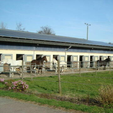
Paddockboxen zu vermieten!!!
Much
Stefan Frings
@Stefan20
Freizeitstall
Vermieten
Hunde willkommen
Krankenbox
Allergikerstall
Hufrehe geeignet
18 weitere...
S


Bergische Weidegründe
Burscheid
Bergische Weidegründe
@HufRehastation-Allergiker
Freizeitstall
Geländestrecke
Hunde willkommen
Krankenbox
Allergikerstall
Gnadenbrothof
Bewegungsstall
Laufstall
28 weitere...
ganz aktuell
S
Deprecated: Creation of dynamic property Zend_View_Helper_Ads::$adLink is deprecated in /var/www/stall-frei/htdocs/staging.stall-frei.de/library/Psf/View/Helper/Ads.php on line 108

***Reitstall Birkenhof*** Pferdegerechte Haltung
Köln
Daniele-Fazzi
@Daniele-Fazzi
Herzlich Willkommen
auf dem Reitstall Birkenhof
Jetzt neu ‼️ auf dem Birkenhof:
Private Geländestrecke rund um unser
Reit- und Pensionspferde Meurer
Bergisch Gladbach
Reit-und-Pensionspferde-Meurer
@Reit-und-Pensionspferde-Meurer
FN-Mitglied
Freizeitstall
Vermieten
Führanlage
Longierzirkel/Roundpen
Außenbox mit Paddock
Außenboxen
14 weitere...
P

Heiderhof Overath
Overath
Heiderhof
@Heiderhof-Overath
Freizeitstall
Vermieten
Hunde willkommen
Longierzirkel/Roundpen
Außenbox mit Paddock
Innenbox
12 weitere...
P
Reitanlage Gut Horst
Bergisch Gladbach
Gut-Horst
@Gut-Horst
Pferdeausbildung
Reitlehrer und -unterricht
Paddock
Parkplatz für Pferdeanhänger
Pferdezucht
Außenboxen
Innenbox
9 weitere...
P

Pferdehof Schwalbennest
Overath
Pferdehof-Schwalbennest
@Pferdehof-Schwalbennest
Freizeitstall
Geländestrecke
Paddock
Pensions- und Gastboxen
Außenboxen
Laufstall
Vollpension
7 weitere...
P

Job gesucht?
Mechtersen
STALL-FREIde Marketing
@STALL-FREI-Marketing
Sie suchen einen Job und arbeiten gerne mit Pferden oder auf Reitanlagen?
Besuchen Sie jetzt unseren Stellenmarkt!

Freizeitstall Gieske
Bergisch Gladbach
Freizeitstall Gieske
@Freizeitstall-Gieske
Freizeitstall
Vermieten
Longierzirkel/Roundpen
Paddock
Außenbox mit Paddock
Innenbox
11 weitere...
P

Offenstall Außenboxen Reitplatz Vollpension
Overath
Big-Charlie-Ranch
@Big-Charlie-Ranch
Freizeitstall
Vermieten
Hunde willkommen
Paddock
Offenstall
9 weitere...
P

Stellplatz für Pferde/Ponys bis 155 cm
Overath
Pferdehof Kartenlennefe
@Thiele-Herrmuth
FN-Mitglied
Freizeitstall
Vermieten
Krankenbox
Paddock
Fohlenaufzucht möglich
Gnadenbrothof
23 weitere...
P

Offenstallplatz
Rösrath
Lemmerhof
@Lemmerhof
Freizeitstall
Krankenbox
Paddock
Allergikerstall
bedampftes/gewaschenes Heu
Laufstall
Offenstall
10 weitere...
P
Werde Teil von STALL-FREI.de
Du hast eine Pferdebox frei? Freie Plätze im Offenstall, Pferdestall oder der Reitanlage kostenlos anbieten.
Deprecated: Creation of dynamic property Zend_View::$pageCount is deprecated in /var/www/stall-frei/htdocs/staging.stall-frei.de/library/vendor/shardj/zf1-future/library/Zend/View/Abstract.php on line 308
Deprecated: Creation of dynamic property Zend_View::$itemCountPerPage is deprecated in /var/www/stall-frei/htdocs/staging.stall-frei.de/library/vendor/shardj/zf1-future/library/Zend/View/Abstract.php on line 308
Deprecated: Creation of dynamic property Zend_View::$first is deprecated in /var/www/stall-frei/htdocs/staging.stall-frei.de/library/vendor/shardj/zf1-future/library/Zend/View/Abstract.php on line 308
Deprecated: Creation of dynamic property Zend_View::$current is deprecated in /var/www/stall-frei/htdocs/staging.stall-frei.de/library/vendor/shardj/zf1-future/library/Zend/View/Abstract.php on line 308
Deprecated: Creation of dynamic property Zend_View::$last is deprecated in /var/www/stall-frei/htdocs/staging.stall-frei.de/library/vendor/shardj/zf1-future/library/Zend/View/Abstract.php on line 308
Deprecated: Creation of dynamic property Zend_View::$previous is deprecated in /var/www/stall-frei/htdocs/staging.stall-frei.de/library/vendor/shardj/zf1-future/library/Zend/View/Abstract.php on line 308
Deprecated: Creation of dynamic property Zend_View::$next is deprecated in /var/www/stall-frei/htdocs/staging.stall-frei.de/library/vendor/shardj/zf1-future/library/Zend/View/Abstract.php on line 308
Deprecated: Creation of dynamic property Zend_View::$pagesInRange is deprecated in /var/www/stall-frei/htdocs/staging.stall-frei.de/library/vendor/shardj/zf1-future/library/Zend/View/Abstract.php on line 308
Deprecated: Creation of dynamic property Zend_View::$firstPageInRange is deprecated in /var/www/stall-frei/htdocs/staging.stall-frei.de/library/vendor/shardj/zf1-future/library/Zend/View/Abstract.php on line 308
Deprecated: Creation of dynamic property Zend_View::$lastPageInRange is deprecated in /var/www/stall-frei/htdocs/staging.stall-frei.de/library/vendor/shardj/zf1-future/library/Zend/View/Abstract.php on line 308
Deprecated: Creation of dynamic property Zend_View::$currentItemCount is deprecated in /var/www/stall-frei/htdocs/staging.stall-frei.de/library/vendor/shardj/zf1-future/library/Zend/View/Abstract.php on line 308
Deprecated: Creation of dynamic property Zend_View::$totalItemCount is deprecated in /var/www/stall-frei/htdocs/staging.stall-frei.de/library/vendor/shardj/zf1-future/library/Zend/View/Abstract.php on line 308
Deprecated: Creation of dynamic property Zend_View::$firstItemNumber is deprecated in /var/www/stall-frei/htdocs/staging.stall-frei.de/library/vendor/shardj/zf1-future/library/Zend/View/Abstract.php on line 308
Deprecated: Creation of dynamic property Zend_View::$lastItemNumber is deprecated in /var/www/stall-frei/htdocs/staging.stall-frei.de/library/vendor/shardj/zf1-future/library/Zend/View/Abstract.php on line 308
Deprecated: Creation of dynamic property Zend_View::$router is deprecated in /var/www/stall-frei/htdocs/staging.stall-frei.de/library/vendor/shardj/zf1-future/library/Zend/View/Abstract.php on line 308
Deprecated: Creation of dynamic property Zend_View::$urlParams is deprecated in /var/www/stall-frei/htdocs/staging.stall-frei.de/library/vendor/shardj/zf1-future/library/Zend/View/Abstract.php on line 308
Deprecated: Creation of dynamic property Zend_View::$showAds is deprecated in /var/www/stall-frei/htdocs/staging.stall-frei.de/library/vendor/shardj/zf1-future/library/Zend/View/Abstract.php on line 308
Deprecated: Creation of dynamic property Zend_View::$objectIds is deprecated in /var/www/stall-frei/htdocs/staging.stall-frei.de/library/vendor/shardj/zf1-future/library/Zend/View/Abstract.php on line 308
Deprecated: Creation of dynamic property Zend_View::$showNavbar is deprecated in /var/www/stall-frei/htdocs/staging.stall-frei.de/library/vendor/shardj/zf1-future/library/Zend/View/Abstract.php on line 308
Deprecated: Creation of dynamic property Zend_View::$showBreadcrumb is deprecated in /var/www/stall-frei/htdocs/staging.stall-frei.de/library/vendor/shardj/zf1-future/library/Zend/View/Abstract.php on line 308
Deprecated: Creation of dynamic property Zend_View::$showFooter is deprecated in /var/www/stall-frei/htdocs/staging.stall-frei.de/library/vendor/shardj/zf1-future/library/Zend/View/Abstract.php on line 308
Deprecated: Creation of dynamic property Zend_View::$showInternalAds is deprecated in /var/www/stall-frei/htdocs/staging.stall-frei.de/library/vendor/shardj/zf1-future/library/Zend/View/Abstract.php on line 308
Deprecated: Creation of dynamic property Zend_View::$blNoContent is deprecated in /var/www/stall-frei/htdocs/staging.stall-frei.de/library/vendor/shardj/zf1-future/library/Zend/View/Abstract.php on line 308
Deprecated: Creation of dynamic property Zend_View::$sMetaDesc is deprecated in /var/www/stall-frei/htdocs/staging.stall-frei.de/library/vendor/shardj/zf1-future/library/Zend/View/Abstract.php on line 308
Deprecated: Creation of dynamic property Zend_View::$useGmaps is deprecated in /var/www/stall-frei/htdocs/staging.stall-frei.de/library/vendor/shardj/zf1-future/library/Zend/View/Abstract.php on line 308
Deprecated: Creation of dynamic property Zend_View::$touches is deprecated in /var/www/stall-frei/htdocs/staging.stall-frei.de/library/vendor/shardj/zf1-future/library/Zend/View/Abstract.php on line 308
Deprecated: Creation of dynamic property Zend_View::$oProject is deprecated in /var/www/stall-frei/htdocs/staging.stall-frei.de/library/vendor/shardj/zf1-future/library/Zend/View/Abstract.php on line 308
Deprecated: Creation of dynamic property Zend_View::$pageHeadline is deprecated in /var/www/stall-frei/htdocs/staging.stall-frei.de/library/vendor/shardj/zf1-future/library/Zend/View/Abstract.php on line 308
Deprecated: Creation of dynamic property Zend_View::$disableLocationField is deprecated in /var/www/stall-frei/htdocs/staging.stall-frei.de/library/vendor/shardj/zf1-future/library/Zend/View/Abstract.php on line 308
Deprecated: Creation of dynamic property Zend_View::$isSearch is deprecated in /var/www/stall-frei/htdocs/staging.stall-frei.de/library/vendor/shardj/zf1-future/library/Zend/View/Abstract.php on line 308
Deprecated: Creation of dynamic property Zend_View::$pageTitle is deprecated in /var/www/stall-frei/htdocs/staging.stall-frei.de/library/vendor/shardj/zf1-future/library/Zend/View/Abstract.php on line 308
Deprecated: Creation of dynamic property Psf_Form_Element_Text::$class is deprecated in /var/www/stall-frei/htdocs/staging.stall-frei.de/library/vendor/shardj/zf1-future/library/Zend/Form/Element.php on line 874
Deprecated: Creation of dynamic property Psf_Form_Element_Text::$size is deprecated in /var/www/stall-frei/htdocs/staging.stall-frei.de/library/vendor/shardj/zf1-future/library/Zend/Form/Element.php on line 874
Deprecated: Creation of dynamic property Psf_Form_Element_Text::$placeholder is deprecated in /var/www/stall-frei/htdocs/staging.stall-frei.de/library/vendor/shardj/zf1-future/library/Zend/Form/Element.php on line 874
Deprecated: Creation of dynamic property Psf_Form_Element_Hidden::$class is deprecated in /var/www/stall-frei/htdocs/staging.stall-frei.de/library/vendor/shardj/zf1-future/library/Zend/Form/Element.php on line 874
Deprecated: Creation of dynamic property Psf_Form_Element_Hidden::$class is deprecated in /var/www/stall-frei/htdocs/staging.stall-frei.de/library/vendor/shardj/zf1-future/library/Zend/Form/Element.php on line 874
Deprecated: Creation of dynamic property Psf_Form_Element_Hidden::$class is deprecated in /var/www/stall-frei/htdocs/staging.stall-frei.de/library/vendor/shardj/zf1-future/library/Zend/Form/Element.php on line 874
Deprecated: Creation of dynamic property Psf_Form_Element_Hidden::$class is deprecated in /var/www/stall-frei/htdocs/staging.stall-frei.de/library/vendor/shardj/zf1-future/library/Zend/Form/Element.php on line 874
Deprecated: Creation of dynamic property Psf_Form_Element_Select::$class is deprecated in /var/www/stall-frei/htdocs/staging.stall-frei.de/library/vendor/shardj/zf1-future/library/Zend/Form/Element.php on line 874
Deprecated: Creation of dynamic property Psf_Form_Element_Select::$class is deprecated in /var/www/stall-frei/htdocs/staging.stall-frei.de/library/vendor/shardj/zf1-future/library/Zend/Form/Element.php on line 874
Deprecated: Creation of dynamic property Psf_Form_Element_Select::$class is deprecated in /var/www/stall-frei/htdocs/staging.stall-frei.de/library/vendor/shardj/zf1-future/library/Zend/Form/Element.php on line 874
Deprecated: Creation of dynamic property Psf_Form_Element_Select::$class is deprecated in /var/www/stall-frei/htdocs/staging.stall-frei.de/library/vendor/shardj/zf1-future/library/Zend/Form/Element.php on line 874
Deprecated: Creation of dynamic property Psf_Form_Element_Text::$class is deprecated in /var/www/stall-frei/htdocs/staging.stall-frei.de/library/vendor/shardj/zf1-future/library/Zend/Form/Element.php on line 874
Deprecated: Creation of dynamic property Psf_Form_Element_Checkbox::$label is deprecated in /var/www/stall-frei/htdocs/staging.stall-frei.de/library/vendor/shardj/zf1-future/library/Zend/Form/Element.php on line 874
Deprecated: Creation of dynamic property Zend_View::$sort is deprecated in /var/www/stall-frei/htdocs/staging.stall-frei.de/library/vendor/shardj/zf1-future/library/Zend/View/Abstract.php on line 308
Deprecated: Creation of dynamic property Zend_View::$searchLocation is deprecated in /var/www/stall-frei/htdocs/staging.stall-frei.de/library/vendor/shardj/zf1-future/library/Zend/View/Abstract.php on line 308
Deprecated: Creation of dynamic property Zend_View::$locationHint is deprecated in /var/www/stall-frei/htdocs/staging.stall-frei.de/library/vendor/shardj/zf1-future/library/Zend/View/Abstract.php on line 308
Psf_GeoCoder_Abstract::getLocation: Sülz Get Location CachedOrLive
Psf_GeoCoder_Abstract::getCachedOrLive: Sülz
Psf_GeoCoder_Abstract::convertLocationResult
{"documentation":"https:\/\/opencagedata.com\/api","licenses":[{"name":"see attribution guide","url":"https:\/\/opencagedata.com\/credits"}],"results":[{"bounds":{"northeast":{"lat":51.0076026,"lng":7.2827448},"southwest":{"lat":50.8514571,"lng":7.1868784}},"components":{"ISO_3166-1_alpha-2":"DE","ISO_3166-1_alpha-3":"DEU","ISO_3166-2":["DE-NW"],"_category":"natural\/water","_normalized_city":"Overath","_type":"river","continent":"Europe","country":"Deutschland","country_code":"de","county":"Rheinisch-Bergischer Kreis","political_union":"European Union","river":"S\u00fclz","state":"Nordrhein-Westfalen","state_code":"NW","town":"Overath"},"confidence":6,"formatted":"S\u00fclz, Overath, Nordrhein-Westfalen, Deutschland","geometry":{"lat":50.946075,"lng":7.2184816}},{"bounds":{"northeast":{"lat":50.9283413,"lng":6.9404644},"southwest":{"lat":50.898319,"lng":6.8799968}},"components":{"ISO_3166-1_alpha-2":"DE","ISO_3166-1_alpha-3":"DEU","ISO_3166-2":["DE-NW"],"_category":"place","_normalized_city":"K\u00f6ln","_type":"neighbourhood","city":"K\u00f6ln","city_district":"Lindenthal","continent":"Europe","country":"Deutschland","country_code":"de","political_union":"European Union","postcode":"50937","state":"Nordrhein-Westfalen","state_code":"NW","suburb":"S\u00fclz"},"confidence":7,"formatted":"50937 K\u00f6ln, Deutschland","geometry":{"lat":50.9189277,"lng":6.9240929}},{"bounds":{"northeast":{"lat":49.151254,"lng":9.7378431},"southwest":{"lat":49.111254,"lng":9.6978431}},"components":{"ISO_3166-1_alpha-2":"DE","ISO_3166-1_alpha-3":"DEU","ISO_3166-2":["DE-BW"],"_category":"place","_normalized_city":"Schw\u00e4bisch Hall","_type":"hamlet","continent":"Europe","country":"Deutschland","country_code":"de","county":"Landkreis Schw\u00e4bisch Hall","hamlet":"S\u00fclz","municipality":"VVG der Stadt Schw\u00e4bisch Hall","political_union":"European Union","postcode":"74547","state":"Baden-W\u00fcrttemberg","state_code":"BW","town":"Schw\u00e4bisch Hall","village":"Gailenkirchen"},"confidence":7,"formatted":"S\u00fclz, 74547 Gailenkirchen, Deutschland","geometry":{"lat":49.131254,"lng":9.7178431}},{"bounds":{"northeast":{"lat":49.7608799,"lng":12.1222796},"southwest":{"lat":49.214384,"lng":11.510927}},"components":{"ISO_3166-1_alpha-2":"DE","ISO_3166-1_alpha-3":"DEU","ISO_3166-2":["DE-BY"],"_category":"place","_type":"county","continent":"Europe","country":"Deutschland","country_code":"de","county":"Landkreis Amberg-Sulzbach","political_union":"European Union","state":"Bayern","state_code":"BY"},"confidence":1,"formatted":"Amberg-Sulzbach, Bayern, Deutschland","geometry":{"lat":49.4801852,"lng":11.7836407}},{"bounds":{"northeast":{"lat":49.5629862,"lng":11.817672},"southwest":{"lat":49.4621792,"lng":11.6639508}},"components":{"ISO_3166-1_alpha-2":"DE","ISO_3166-1_alpha-3":"DEU","ISO_3166-2":["DE-BY"],"_category":"place","_normalized_city":"Sulzbach-Rosenberg","_type":"municipality","continent":"Europe","country":"Deutschland","country_code":"de","county":"Landkreis Amberg-Sulzbach","municipality":"Sulzbach-Rosenberg","political_union":"European Union","postcode":"92237","state":"Bayern","state_code":"BY"},"confidence":6,"formatted":"92237 Sulzbach-Rosenberg, Deutschland","geometry":{"lat":49.4992468,"lng":11.7470259}},{"components":{"ISO_3166-1_alpha-2":"FR","ISO_3166-1_alpha-3":"FRA","ISO_3166-2":["FR-NAQ","FR-17"],"_category":"road","_normalized_city":"Montendre","_type":"road","city":"Montendre","continent":"Europe","country":"France","country_code":"fr","county":"Charente-Maritime","local_authority":"Communaut\u00e9 de communes de la Haute Saintonge","political_union":"European Union","postcode":"17130","road":"Avenue de Sulz Am Neckar","state":"Nouvelle-Aquitaine","state_code":"NAQ"},"confidence":2,"formatted":"Avenue de Sulz Am Neckar, 17130 Montendre, France","geometry":{"lat":45.2812,"lng":-0.393835}},{"components":{"ISO_3166-1_alpha-2":"FR","ISO_3166-1_alpha-3":"FRA","ISO_3166-2":["FR-OCC","FR-11"],"_category":"road","_normalized_city":"Carcassonne","_type":"road","city":"Carcassonne","continent":"Europe","country":"France","country_code":"fr","county":"Aude","local_authority":"Carcassonne Agglo","political_union":"European Union","postcode":"11000","road":"All\u00e9e de la Salz","state":"Occitanie","state_code":"OCC"},"confidence":2,"formatted":"All\u00e9e de la Salz, 11000 Carcassonne, France","geometry":{"lat":43.209823,"lng":2.381359}},{"components":{"ISO_3166-1_alpha-2":"FR","ISO_3166-1_alpha-3":"FRA","ISO_3166-2":["FR-OCC","FR-30"],"_category":"road","_normalized_city":"Chamborigaud","_type":"road","city":"Chamborigaud","continent":"Europe","country":"France","country_code":"fr","county":"Gard","local_authority":"Al\u00e8s Agglom\u00e9ration","political_union":"European Union","postcode":"30530","road":"Chemin de Salze","state":"Occitanie","state_code":"OCC"},"confidence":10,"formatted":"Chemin de Salze, 30530 Chamborigaud, France","geometry":{"lat":44.296988,"lng":3.976294}},{"components":{"ISO_3166-1_alpha-2":"FR","ISO_3166-1_alpha-3":"FRA","ISO_3166-2":["FR-OCC","FR-11"],"_category":"road","_normalized_city":"Couiza","_type":"road","city":"Couiza","continent":"Europe","country":"France","country_code":"fr","county":"Aude","local_authority":"Communaut\u00e9 de communes du Limouxin","political_union":"European Union","postcode":"11190","road":"Rue de Salz","state":"Occitanie","state_code":"OCC"},"confidence":10,"formatted":"Rue de Salz, 11190 Couiza, France","geometry":{"lat":42.942248,"lng":2.255413}},{"components":{"ISO_3166-1_alpha-2":"FR","ISO_3166-1_alpha-3":"FRA","ISO_3166-2":["FR-OCC","FR-30"],"_category":"road","_normalized_city":"Portes","_type":"road","city":"Portes","continent":"Europe","country":"France","country_code":"fr","county":"Gard","local_authority":"Al\u00e8s Agglom\u00e9ration","political_union":"European Union","postcode":"30530","road":"Chemin de Salze","state":"Occitanie","state_code":"OCC"},"confidence":10,"formatted":"Chemin de Salze, 30530 Portes, France","geometry":{"lat":44.270399,"lng":4.020834}}],"status":{"code":200,"message":"OK"},"stay_informed":{"blog":"https:\/\/blog.opencagedata.com","mastodon":"https:\/\/en.osm.town\/@opencage"},"thanks":"For using an OpenCage API","timestamp":{"created_http":"Sun, 08 Feb 2026 06:34:08 GMT","created_unix":1770532448},"total_results":10}Array
(
[0] => stdClass Object
(
[bounds] => stdClass Object
(
[northeast] => stdClass Object
(
[lat] => 51.0076026
[lng] => 7.2827448
)
[southwest] => stdClass Object
(
[lat] => 50.8514571
[lng] => 7.1868784
)
)
[components] => stdClass Object
(
[ISO_3166-1_alpha-2] => DE
[ISO_3166-1_alpha-3] => DEU
[ISO_3166-2] => Array
(
[0] => DE-NW
)
[_category] => natural/water
[_normalized_city] => Overath
[_type] => river
[continent] => Europe
[country] => Deutschland
[country_code] => de
[county] => Rheinisch-Bergischer Kreis
[political_union] => European Union
[river] => Sülz
[state] => Nordrhein-Westfalen
[state_code] => NW
[town] => Overath
)
[confidence] => 6
[formatted] => Sülz, Overath, Nordrhein-Westfalen, Deutschland
[geometry] => stdClass Object
(
[lat] => 50.946075
[lng] => 7.2184816
)
)
[1] => stdClass Object
(
[bounds] => stdClass Object
(
[northeast] => stdClass Object
(
[lat] => 50.9283413
[lng] => 6.9404644
)
[southwest] => stdClass Object
(
[lat] => 50.898319
[lng] => 6.8799968
)
)
[components] => stdClass Object
(
[ISO_3166-1_alpha-2] => DE
[ISO_3166-1_alpha-3] => DEU
[ISO_3166-2] => Array
(
[0] => DE-NW
)
[_category] => place
[_normalized_city] => Köln
[_type] => neighbourhood
[city] => Köln
[city_district] => Lindenthal
[continent] => Europe
[country] => Deutschland
[country_code] => de
[political_union] => European Union
[postcode] => 50937
[state] => Nordrhein-Westfalen
[state_code] => NW
[suburb] => Sülz
)
[confidence] => 7
[formatted] => 50937 Köln, Deutschland
[geometry] => stdClass Object
(
[lat] => 50.9189277
[lng] => 6.9240929
)
)
[2] => stdClass Object
(
[bounds] => stdClass Object
(
[northeast] => stdClass Object
(
[lat] => 49.151254
[lng] => 9.7378431
)
[southwest] => stdClass Object
(
[lat] => 49.111254
[lng] => 9.6978431
)
)
[components] => stdClass Object
(
[ISO_3166-1_alpha-2] => DE
[ISO_3166-1_alpha-3] => DEU
[ISO_3166-2] => Array
(
[0] => DE-BW
)
[_category] => place
[_normalized_city] => Schwäbisch Hall
[_type] => hamlet
[continent] => Europe
[country] => Deutschland
[country_code] => de
[county] => Landkreis Schwäbisch Hall
[hamlet] => Sülz
[municipality] => VVG der Stadt Schwäbisch Hall
[political_union] => European Union
[postcode] => 74547
[state] => Baden-Württemberg
[state_code] => BW
[town] => Schwäbisch Hall
[village] => Gailenkirchen
)
[confidence] => 7
[formatted] => Sülz, 74547 Gailenkirchen, Deutschland
[geometry] => stdClass Object
(
[lat] => 49.131254
[lng] => 9.7178431
)
)
[3] => stdClass Object
(
[bounds] => stdClass Object
(
[northeast] => stdClass Object
(
[lat] => 49.7608799
[lng] => 12.1222796
)
[southwest] => stdClass Object
(
[lat] => 49.214384
[lng] => 11.510927
)
)
[components] => stdClass Object
(
[ISO_3166-1_alpha-2] => DE
[ISO_3166-1_alpha-3] => DEU
[ISO_3166-2] => Array
(
[0] => DE-BY
)
[_category] => place
[_type] => county
[continent] => Europe
[country] => Deutschland
[country_code] => de
[county] => Landkreis Amberg-Sulzbach
[political_union] => European Union
[state] => Bayern
[state_code] => BY
)
[confidence] => 1
[formatted] => Amberg-Sulzbach, Bayern, Deutschland
[geometry] => stdClass Object
(
[lat] => 49.4801852
[lng] => 11.7836407
)
)
[4] => stdClass Object
(
[bounds] => stdClass Object
(
[northeast] => stdClass Object
(
[lat] => 49.5629862
[lng] => 11.817672
)
[southwest] => stdClass Object
(
[lat] => 49.4621792
[lng] => 11.6639508
)
)
[components] => stdClass Object
(
[ISO_3166-1_alpha-2] => DE
[ISO_3166-1_alpha-3] => DEU
[ISO_3166-2] => Array
(
[0] => DE-BY
)
[_category] => place
[_normalized_city] => Sulzbach-Rosenberg
[_type] => municipality
[continent] => Europe
[country] => Deutschland
[country_code] => de
[county] => Landkreis Amberg-Sulzbach
[municipality] => Sulzbach-Rosenberg
[political_union] => European Union
[postcode] => 92237
[state] => Bayern
[state_code] => BY
)
[confidence] => 6
[formatted] => 92237 Sulzbach-Rosenberg, Deutschland
[geometry] => stdClass Object
(
[lat] => 49.4992468
[lng] => 11.7470259
)
)
[5] => stdClass Object
(
[components] => stdClass Object
(
[ISO_3166-1_alpha-2] => FR
[ISO_3166-1_alpha-3] => FRA
[ISO_3166-2] => Array
(
[0] => FR-NAQ
[1] => FR-17
)
[_category] => road
[_normalized_city] => Montendre
[_type] => road
[city] => Montendre
[continent] => Europe
[country] => France
[country_code] => fr
[county] => Charente-Maritime
[local_authority] => Communauté de communes de la Haute Saintonge
[political_union] => European Union
[postcode] => 17130
[road] => Avenue de Sulz Am Neckar
[state] => Nouvelle-Aquitaine
[state_code] => NAQ
)
[confidence] => 2
[formatted] => Avenue de Sulz Am Neckar, 17130 Montendre, France
[geometry] => stdClass Object
(
[lat] => 45.2812
[lng] => -0.393835
)
)
[6] => stdClass Object
(
[components] => stdClass Object
(
[ISO_3166-1_alpha-2] => FR
[ISO_3166-1_alpha-3] => FRA
[ISO_3166-2] => Array
(
[0] => FR-OCC
[1] => FR-11
)
[_category] => road
[_normalized_city] => Carcassonne
[_type] => road
[city] => Carcassonne
[continent] => Europe
[country] => France
[country_code] => fr
[county] => Aude
[local_authority] => Carcassonne Agglo
[political_union] => European Union
[postcode] => 11000
[road] => Allée de la Salz
[state] => Occitanie
[state_code] => OCC
)
[confidence] => 2
[formatted] => Allée de la Salz, 11000 Carcassonne, France
[geometry] => stdClass Object
(
[lat] => 43.209823
[lng] => 2.381359
)
)
[7] => stdClass Object
(
[components] => stdClass Object
(
[ISO_3166-1_alpha-2] => FR
[ISO_3166-1_alpha-3] => FRA
[ISO_3166-2] => Array
(
[0] => FR-OCC
[1] => FR-30
)
[_category] => road
[_normalized_city] => Chamborigaud
[_type] => road
[city] => Chamborigaud
[continent] => Europe
[country] => France
[country_code] => fr
[county] => Gard
[local_authority] => Alès Agglomération
[political_union] => European Union
[postcode] => 30530
[road] => Chemin de Salze
[state] => Occitanie
[state_code] => OCC
)
[confidence] => 10
[formatted] => Chemin de Salze, 30530 Chamborigaud, France
[geometry] => stdClass Object
(
[lat] => 44.296988
[lng] => 3.976294
)
)
[8] => stdClass Object
(
[components] => stdClass Object
(
[ISO_3166-1_alpha-2] => FR
[ISO_3166-1_alpha-3] => FRA
[ISO_3166-2] => Array
(
[0] => FR-OCC
[1] => FR-11
)
[_category] => road
[_normalized_city] => Couiza
[_type] => road
[city] => Couiza
[continent] => Europe
[country] => France
[country_code] => fr
[county] => Aude
[local_authority] => Communauté de communes du Limouxin
[political_union] => European Union
[postcode] => 11190
[road] => Rue de Salz
[state] => Occitanie
[state_code] => OCC
)
[confidence] => 10
[formatted] => Rue de Salz, 11190 Couiza, France
[geometry] => stdClass Object
(
[lat] => 42.942248
[lng] => 2.255413
)
)
[9] => stdClass Object
(
[components] => stdClass Object
(
[ISO_3166-1_alpha-2] => FR
[ISO_3166-1_alpha-3] => FRA
[ISO_3166-2] => Array
(
[0] => FR-OCC
[1] => FR-30
)
[_category] => road
[_normalized_city] => Portes
[_type] => road
[city] => Portes
[continent] => Europe
[country] => France
[country_code] => fr
[county] => Gard
[local_authority] => Alès Agglomération
[political_union] => European Union
[postcode] => 30530
[road] => Chemin de Salze
[state] => Occitanie
[state_code] => OCC
)
[confidence] => 10
[formatted] => Chemin de Salze, 30530 Portes, France
[geometry] => stdClass Object
(
[lat] => 44.270399
[lng] => 4.020834
)
)
)
Psf_GeoCoder_OpenCageData::getKeyMap: 0
stdClass Object
(
    [bounds] => stdClass Object
        (
            [northeast] => stdClass Object
                (
                    [lat] => 51.0076026
                    [lng] => 7.2827448
                )

            [southwest] => stdClass Object
                (
                    [lat] => 50.8514571
                    [lng] => 7.1868784
                )

        )

    [components] => stdClass Object
        (
            [ISO_3166-1_alpha-2] => DE
            [ISO_3166-1_alpha-3] => DEU
            [ISO_3166-2] => Array
                (
                    [0] => DE-NW
                )

            [_category] => natural/water
            [_normalized_city] => Overath
            [_type] => river
            [continent] => Europe
            [country] => Deutschland
            [country_code] => de
            [county] => Rheinisch-Bergischer Kreis
            [political_union] => European Union
            [river] => Sülz
            [state] => Nordrhein-Westfalen
            [state_code] => NW
            [town] => Overath
        )

    [confidence] => 6
    [formatted] => Sülz, Overath, Nordrhein-Westfalen, Deutschland
    [geometry] => stdClass Object
        (
            [lat] => 50.946075
            [lng] => 7.2184816
        )

)
Psf_GeoCoder_OpenCageData::getCounty: Rheinisch-Bergischer Kreis
Psf_GeoCoder_OpenCageData::addMissingData REFETCH!
Array
(
    [address] => Sülz, Overath, Nordrhein-Westfalen, Deutschland
    [type] => river
    [street] =>
    [city] => Overath
    [county] => Rheinisch-Bergischer Kreis
    [state] => Nordrhein-Westfalen
    [zip] =>
    [country] => Deutschland
    [suburb] =>
    [countrycode] => de
    [latitude] => 50.946075
    [longitude] => 7.2184816
    [accuracy] => 1
    [confidence] => 6
    [bounds] => stdClass Object
        (
            [northeast] => stdClass Object
                (
                    [lat] => 51.0076026
                    [lng] => 7.2827448
                )

            [southwest] => stdClass Object
                (
                    [lat] => 50.8514571
                    [lng] => 7.1868784
                )

        )

)
reformat!
Array
(
    [address] => Sülz, Overath, Nordrhein-Westfalen, Deutschland
    [type] => river
    [street] =>
    [city] => Overath
    [county] => Rheinisch-Bergischer Kreis
    [state] => Nordrhein-Westfalen
    [zip] =>
    [country] => Deutschland
    [suburb] =>
    [countrycode] => de
    [latitude] => 50.946075
    [longitude] => 7.2184816
    [accuracy] => 1
    [confidence] => 6
    [bounds] => stdClass Object
        (
            [northeast] => stdClass Object
                (
                    [lat] => 51.0076026
                    [lng] => 7.2827448
                )

            [southwest] => stdClass Object
                (
                    [lat] => 50.8514571
                    [lng] => 7.1868784
                )

        )

    [place] => Overath, Nordrhein-Westfalen
    [hash] => c9672185eee4e0a4dbc0a27ecf57a0bc
)
Psf_GeoCoder_OpenCageData::getKeyMap: 1
stdClass Object
(
    [bounds] => stdClass Object
        (
            [northeast] => stdClass Object
                (
                    [lat] => 50.9283413
                    [lng] => 6.9404644
                )

            [southwest] => stdClass Object
                (
                    [lat] => 50.898319
                    [lng] => 6.8799968
                )

        )

    [components] => stdClass Object
        (
            [ISO_3166-1_alpha-2] => DE
            [ISO_3166-1_alpha-3] => DEU
            [ISO_3166-2] => Array
                (
                    [0] => DE-NW
                )

            [_category] => place
            [_normalized_city] => Köln
            [_type] => neighbourhood
            [city] => Köln
            [city_district] => Lindenthal
            [continent] => Europe
            [country] => Deutschland
            [country_code] => de
            [political_union] => European Union
            [postcode] => 50937
            [state] => Nordrhein-Westfalen
            [state_code] => NW
            [suburb] => Sülz
        )

    [confidence] => 7
    [formatted] => 50937 Köln, Deutschland
    [geometry] => stdClass Object
        (
            [lat] => 50.9189277
            [lng] => 6.9240929
        )

)
Psf_GeoCoder_OpenCageData::getCounty: Köln
Psf_GeoCoder_OpenCageData::addMissingData REFETCH!
Array
(
    [address] => 50937 Köln, Deutschland
    [type] => neighbourhood
    [street] =>
    [city] => Sülz
    [county] => Köln
    [state] => Nordrhein-Westfalen
    [zip] => 50937
    [country] => Deutschland
    [suburb] => Sülz
    [countrycode] => de
    [latitude] => 50.9189277
    [longitude] => 6.9240929
    [accuracy] => 1
    [confidence] => 7
    [bounds] => stdClass Object
        (
            [northeast] => stdClass Object
                (
                    [lat] => 50.9283413
                    [lng] => 6.9404644
                )

            [southwest] => stdClass Object
                (
                    [lat] => 50.898319
                    [lng] => 6.8799968
                )

        )

)
reformat!
Array
(
    [address] => 50937 Sülz
    [type] => neighbourhood
    [street] =>
    [city] => Sülz
    [county] => Köln
    [state] => Nordrhein-Westfalen
    [zip] => 50937
    [country] => Deutschland
    [suburb] => Sülz
    [countrycode] => de
    [latitude] => 50.9189277
    [longitude] => 6.9240929
    [accuracy] => 1
    [confidence] => 7
    [bounds] => stdClass Object
        (
            [northeast] => stdClass Object
                (
                    [lat] => 50.9283413
                    [lng] => 6.9404644
                )

            [southwest] => stdClass Object
                (
                    [lat] => 50.898319
                    [lng] => 6.8799968
                )

        )

    [place] => 50937 Sülz, Nordrhein-Westfalen
    [hash] => 74e923a215c9254a425d8ec1c002d931
)
Psf_GeoCoder_OpenCageData::getKeyMap: 2
stdClass Object
(
    [bounds] => stdClass Object
        (
            [northeast] => stdClass Object
                (
                    [lat] => 49.151254
                    [lng] => 9.7378431
                )

            [southwest] => stdClass Object
                (
                    [lat] => 49.111254
                    [lng] => 9.6978431
                )

        )

    [components] => stdClass Object
        (
            [ISO_3166-1_alpha-2] => DE
            [ISO_3166-1_alpha-3] => DEU
            [ISO_3166-2] => Array
                (
                    [0] => DE-BW
                )

            [_category] => place
            [_normalized_city] => Schwäbisch Hall
            [_type] => hamlet
            [continent] => Europe
            [country] => Deutschland
            [country_code] => de
            [county] => Landkreis Schwäbisch Hall
            [hamlet] => Sülz
            [municipality] => VVG der Stadt Schwäbisch Hall
            [political_union] => European Union
            [postcode] => 74547
            [state] => Baden-Württemberg
            [state_code] => BW
            [town] => Schwäbisch Hall
            [village] => Gailenkirchen
        )

    [confidence] => 7
    [formatted] => Sülz, 74547 Gailenkirchen, Deutschland
    [geometry] => stdClass Object
        (
            [lat] => 49.131254
            [lng] => 9.7178431
        )

)
Psf_GeoCoder_OpenCageData::getCounty: Schwäbisch Hall
Psf_GeoCoder_OpenCageData::addMissingData REFETCH!
Array
(
    [address] => Sülz, 74547 Gailenkirchen, Deutschland
    [type] => hamlet
    [street] => Sülz
    [city] => Schwäbisch Hall
    [county] => Schwäbisch Hall
    [state] => Baden-Württemberg
    [zip] => 74547
    [country] => Deutschland
    [suburb] =>
    [countrycode] => de
    [latitude] => 49.131254
    [longitude] => 9.7178431
    [accuracy] => 1
    [confidence] => 7
    [bounds] => stdClass Object
        (
            [northeast] => stdClass Object
                (
                    [lat] => 49.151254
                    [lng] => 9.7378431
                )

            [southwest] => stdClass Object
                (
                    [lat] => 49.111254
                    [lng] => 9.6978431
                )

        )

)
reformat!
Array
(
    [address] => Sülz, 74547 Schwäbisch Hall
    [type] => hamlet
    [street] => Sülz
    [city] => Schwäbisch Hall
    [county] => Schwäbisch Hall
    [state] => Baden-Württemberg
    [zip] => 74547
    [country] => Deutschland
    [suburb] =>
    [countrycode] => de
    [latitude] => 49.131254
    [longitude] => 9.7178431
    [accuracy] => 1
    [confidence] => 7
    [bounds] => stdClass Object
        (
            [northeast] => stdClass Object
                (
                    [lat] => 49.151254
                    [lng] => 9.7378431
                )

            [southwest] => stdClass Object
                (
                    [lat] => 49.111254
                    [lng] => 9.6978431
                )

        )

    [place] => Sülz, 74547 Schwäbisch Hall, Baden-Württemberg
    [hash] => c19ca35f30c6490635036515ae5cd367
)
Psf_GeoCoder_OpenCageData::getKeyMap: 3
stdClass Object
(
    [bounds] => stdClass Object
        (
            [northeast] => stdClass Object
                (
                    [lat] => 49.7608799
                    [lng] => 12.1222796
                )

            [southwest] => stdClass Object
                (
                    [lat] => 49.214384
                    [lng] => 11.510927
                )

        )

    [components] => stdClass Object
        (
            [ISO_3166-1_alpha-2] => DE
            [ISO_3166-1_alpha-3] => DEU
            [ISO_3166-2] => Array
                (
                    [0] => DE-BY
                )

            [_category] => place
            [_type] => county
            [continent] => Europe
            [country] => Deutschland
            [country_code] => de
            [county] => Landkreis Amberg-Sulzbach
            [political_union] => European Union
            [state] => Bayern
            [state_code] => BY
        )

    [confidence] => 1
    [formatted] => Amberg-Sulzbach, Bayern, Deutschland
    [geometry] => stdClass Object
        (
            [lat] => 49.4801852
            [lng] => 11.7836407
        )

)
Psf_GeoCoder_OpenCageData::getCounty: Amberg-Sulzbach
Psf_GeoCoder_OpenCageData::addMissingData REFETCH!
Array
(
    [address] => Amberg-Sulzbach, Bayern, Deutschland
    [type] => county
    [street] =>
    [city] =>
    [county] => Amberg-Sulzbach
    [state] => Bayern
    [zip] =>
    [country] => Deutschland
    [suburb] =>
    [countrycode] => de
    [latitude] => 49.4801852
    [longitude] => 11.7836407
    [accuracy] => 1
    [confidence] => 1
    [bounds] => stdClass Object
        (
            [northeast] => stdClass Object
                (
                    [lat] => 49.7608799
                    [lng] => 12.1222796
                )

            [southwest] => stdClass Object
                (
                    [lat] => 49.214384
                    [lng] => 11.510927
                )

        )

)
reformat!
Array
(
    [address] => Amberg-Sulzbach, Bayern, Deutschland
    [type] => county
    [street] =>
    [city] =>
    [county] => Amberg-Sulzbach
    [state] => Bayern
    [zip] =>
    [country] => Deutschland
    [suburb] =>
    [countrycode] => de
    [latitude] => 49.4801852
    [longitude] => 11.7836407
    [accuracy] => 1
    [confidence] => 1
    [bounds] => stdClass Object
        (
            [northeast] => stdClass Object
                (
                    [lat] => 49.7608799
                    [lng] => 12.1222796
                )

            [southwest] => stdClass Object
                (
                    [lat] => 49.214384
                    [lng] => 11.510927
                )

        )

    [place] => , Bayern
    [hash] => 665b3ba80c07f525effa36eea15d58d9
)
Psf_GeoCoder_OpenCageData::getKeyMap: 4
stdClass Object
(
    [bounds] => stdClass Object
        (
            [northeast] => stdClass Object
                (
                    [lat] => 49.5629862
                    [lng] => 11.817672
                )

            [southwest] => stdClass Object
                (
                    [lat] => 49.4621792
                    [lng] => 11.6639508
                )

        )

    [components] => stdClass Object
        (
            [ISO_3166-1_alpha-2] => DE
            [ISO_3166-1_alpha-3] => DEU
            [ISO_3166-2] => Array
                (
                    [0] => DE-BY
                )

            [_category] => place
            [_normalized_city] => Sulzbach-Rosenberg
            [_type] => municipality
            [continent] => Europe
            [country] => Deutschland
            [country_code] => de
            [county] => Landkreis Amberg-Sulzbach
            [municipality] => Sulzbach-Rosenberg
            [political_union] => European Union
            [postcode] => 92237
            [state] => Bayern
            [state_code] => BY
        )

    [confidence] => 6
    [formatted] => 92237 Sulzbach-Rosenberg, Deutschland
    [geometry] => stdClass Object
        (
            [lat] => 49.4992468
            [lng] => 11.7470259
        )

)
Psf_GeoCoder_OpenCageData::getCounty: Amberg-Sulzbach
Psf_GeoCoder_OpenCageData::addMissingData REFETCH!
Array
(
    [address] => 92237 Sulzbach-Rosenberg, Deutschland
    [type] => municipality
    [street] =>
    [city] =>
    [county] => Amberg-Sulzbach
    [state] => Bayern
    [zip] => 92237
    [country] => Deutschland
    [suburb] =>
    [countrycode] => de
    [latitude] => 49.4992468
    [longitude] => 11.7470259
    [accuracy] => 1
    [confidence] => 6
    [bounds] => stdClass Object
        (
            [northeast] => stdClass Object
                (
                    [lat] => 49.5629862
                    [lng] => 11.817672
                )

            [southwest] => stdClass Object
                (
                    [lat] => 49.4621792
                    [lng] => 11.6639508
                )

        )

)
reformat!
Array
(
    [address] => 92237 Sulzbach-Rosenberg, Deutschland
    [type] => municipality
    [street] =>
    [city] =>
    [county] => Amberg-Sulzbach
    [state] => Bayern
    [zip] => 92237
    [country] => Deutschland
    [suburb] =>
    [countrycode] => de
    [latitude] => 49.4992468
    [longitude] => 11.7470259
    [accuracy] => 1
    [confidence] => 6
    [bounds] => stdClass Object
        (
            [northeast] => stdClass Object
                (
                    [lat] => 49.5629862
                    [lng] => 11.817672
                )

            [southwest] => stdClass Object
                (
                    [lat] => 49.4621792
                    [lng] => 11.6639508
                )

        )

    [place] => 92237 , Bayern
    [hash] => 032674eb7bfcb01ec2e9b5dc7f9d4de9
)
Psf_GeoCoder_OpenCageData::getKeyMap: 5
stdClass Object
(
    [components] => stdClass Object
        (
            [ISO_3166-1_alpha-2] => FR
            [ISO_3166-1_alpha-3] => FRA
            [ISO_3166-2] => Array
                (
                    [0] => FR-NAQ
                    [1] => FR-17
                )

            [_category] => road
            [_normalized_city] => Montendre
            [_type] => road
            [city] => Montendre
            [continent] => Europe
            [country] => France
            [country_code] => fr
            [county] => Charente-Maritime
            [local_authority] => Communauté de communes de la Haute Saintonge
            [political_union] => European Union
            [postcode] => 17130
            [road] => Avenue de Sulz Am Neckar
            [state] => Nouvelle-Aquitaine
            [state_code] => NAQ
        )

    [confidence] => 2
    [formatted] => Avenue de Sulz Am Neckar, 17130 Montendre, France
    [geometry] => stdClass Object
        (
            [lat] => 45.2812
            [lng] => -0.393835
        )

)
Psf_GeoCoder_OpenCageData::getCounty: Charente-Maritime
Psf_GeoCoder_OpenCageData::addMissingData REFETCH!
Array
(
    [address] => Avenue de Sulz Am Neckar, 17130 Montendre, France
    [type] => road
    [street] => Avenue de Sulz Am Neckar
    [city] => Montendre
    [county] => Charente-Maritime
    [state] => Nouvelle-Aquitaine
    [zip] => 17130
    [country] => France
    [suburb] =>
    [countrycode] => fr
    [latitude] => 45.2812
    [longitude] => -0.393835
    [accuracy] => 1
    [confidence] => 2
    [bounds] =>
)
reformat!
Array
(
    [address] => Avenue de Sulz Am Neckar, 17130 Montendre, France
    [type] => road
    [street] => Avenue de Sulz Am Neckar
    [city] => Montendre
    [county] => Charente-Maritime
    [state] => Nouvelle-Aquitaine
    [zip] => 17130
    [country] => France
    [suburb] =>
    [countrycode] => fr
    [latitude] => 45.2812
    [longitude] => -0.393835
    [accuracy] => 1
    [confidence] => 2
    [bounds] =>
    [place] => Avenue de Sulz Am Neckar, 17130 Montendre, Nouvelle-Aquitaine
    [hash] => 26c42b637f41cfac08e26f9bb20349db
)
Psf_GeoCoder_OpenCageData::getKeyMap: 6
stdClass Object
(
    [components] => stdClass Object
        (
            [ISO_3166-1_alpha-2] => FR
            [ISO_3166-1_alpha-3] => FRA
            [ISO_3166-2] => Array
                (
                    [0] => FR-OCC
                    [1] => FR-11
                )

            [_category] => road
            [_normalized_city] => Carcassonne
            [_type] => road
            [city] => Carcassonne
            [continent] => Europe
            [country] => France
            [country_code] => fr
            [county] => Aude
            [local_authority] => Carcassonne Agglo
            [political_union] => European Union
            [postcode] => 11000
            [road] => Allée de la Salz
            [state] => Occitanie
            [state_code] => OCC
        )

    [confidence] => 2
    [formatted] => Allée de la Salz, 11000 Carcassonne, France
    [geometry] => stdClass Object
        (
            [lat] => 43.209823
            [lng] => 2.381359
        )

)
Psf_GeoCoder_OpenCageData::getCounty: Aude
Psf_GeoCoder_OpenCageData::addMissingData REFETCH!
Array
(
    [address] => Allée de la Salz, 11000 Carcassonne, France
    [type] => road
    [street] => Allée de la Salz
    [city] => Carcassonne
    [county] => Aude
    [state] => Occitanie
    [zip] => 11000
    [country] => France
    [suburb] =>
    [countrycode] => fr
    [latitude] => 43.209823
    [longitude] => 2.381359
    [accuracy] => 1
    [confidence] => 2
    [bounds] =>
)
reformat!
Array
(
    [address] => Allée de la Salz, 11000 Carcassonne, France
    [type] => road
    [street] => Allée de la Salz
    [city] => Carcassonne
    [county] => Aude
    [state] => Occitanie
    [zip] => 11000
    [country] => France
    [suburb] =>
    [countrycode] => fr
    [latitude] => 43.209823
    [longitude] => 2.381359
    [accuracy] => 1
    [confidence] => 2
    [bounds] =>
    [place] => Allée de la Salz, 11000 Carcassonne, Occitanie
    [hash] => a7043f9e97c0fd0ce2cbf0f48e592779
)
Psf_GeoCoder_OpenCageData::getKeyMap: 7
stdClass Object
(
    [components] => stdClass Object
        (
            [ISO_3166-1_alpha-2] => FR
            [ISO_3166-1_alpha-3] => FRA
            [ISO_3166-2] => Array
                (
                    [0] => FR-OCC
                    [1] => FR-30
                )

            [_category] => road
            [_normalized_city] => Chamborigaud
            [_type] => road
            [city] => Chamborigaud
            [continent] => Europe
            [country] => France
            [country_code] => fr
            [county] => Gard
            [local_authority] => Alès Agglomération
            [political_union] => European Union
            [postcode] => 30530
            [road] => Chemin de Salze
            [state] => Occitanie
            [state_code] => OCC
        )

    [confidence] => 10
    [formatted] => Chemin de Salze, 30530 Chamborigaud, France
    [geometry] => stdClass Object
        (
            [lat] => 44.296988
            [lng] => 3.976294
        )

)
Psf_GeoCoder_OpenCageData::getCounty: Gard
Psf_GeoCoder_OpenCageData::addMissingData REFETCH!
Array
(
    [address] => Chemin de Salze, 30530 Chamborigaud, France
    [type] => road
    [street] => Chemin de Salze
    [city] => Chamborigaud
    [county] => Gard
    [state] => Occitanie
    [zip] => 30530
    [country] => France
    [suburb] =>
    [countrycode] => fr
    [latitude] => 44.296988
    [longitude] => 3.976294
    [accuracy] => 1
    [confidence] => 10
    [bounds] =>
)
reformat!
Array
(
    [address] => Chemin de Salze, 30530 Chamborigaud, France
    [type] => road
    [street] => Chemin de Salze
    [city] => Chamborigaud
    [county] => Gard
    [state] => Occitanie
    [zip] => 30530
    [country] => France
    [suburb] =>
    [countrycode] => fr
    [latitude] => 44.296988
    [longitude] => 3.976294
    [accuracy] => 1
    [confidence] => 10
    [bounds] =>
    [place] => Chemin de Salze, 30530 Chamborigaud, Occitanie
    [hash] => 0c42bd5fd7c1c895d3d109077ccb4da5
)
Psf_GeoCoder_OpenCageData::getKeyMap: 8
stdClass Object
(
    [components] => stdClass Object
        (
            [ISO_3166-1_alpha-2] => FR
            [ISO_3166-1_alpha-3] => FRA
            [ISO_3166-2] => Array
                (
                    [0] => FR-OCC
                    [1] => FR-11
                )

            [_category] => road
            [_normalized_city] => Couiza
            [_type] => road
            [city] => Couiza
            [continent] => Europe
            [country] => France
            [country_code] => fr
            [county] => Aude
            [local_authority] => Communauté de communes du Limouxin
            [political_union] => European Union
            [postcode] => 11190
            [road] => Rue de Salz
            [state] => Occitanie
            [state_code] => OCC
        )

    [confidence] => 10
    [formatted] => Rue de Salz, 11190 Couiza, France
    [geometry] => stdClass Object
        (
            [lat] => 42.942248
            [lng] => 2.255413
        )

)
Psf_GeoCoder_OpenCageData::getCounty: Aude
Psf_GeoCoder_OpenCageData::addMissingData REFETCH!
Array
(
    [address] => Rue de Salz, 11190 Couiza, France
    [type] => road
    [street] => Rue de Salz
    [city] => Couiza
    [county] => Aude
    [state] => Occitanie
    [zip] => 11190
    [country] => France
    [suburb] =>
    [countrycode] => fr
    [latitude] => 42.942248
    [longitude] => 2.255413
    [accuracy] => 1
    [confidence] => 10
    [bounds] =>
)
reformat!
Array
(
    [address] => Rue de Salz, 11190 Couiza, France
    [type] => road
    [street] => Rue de Salz
    [city] => Couiza
    [county] => Aude
    [state] => Occitanie
    [zip] => 11190
    [country] => France
    [suburb] =>
    [countrycode] => fr
    [latitude] => 42.942248
    [longitude] => 2.255413
    [accuracy] => 1
    [confidence] => 10
    [bounds] =>
    [place] => Rue de Salz, 11190 Couiza, Occitanie
    [hash] => 14ea5bd72e4a5aacba68a176de19f3a6
)
Psf_GeoCoder_OpenCageData::getKeyMap: 9
stdClass Object
(
    [components] => stdClass Object
        (
            [ISO_3166-1_alpha-2] => FR
            [ISO_3166-1_alpha-3] => FRA
            [ISO_3166-2] => Array
                (
                    [0] => FR-OCC
                    [1] => FR-30
                )

            [_category] => road
            [_normalized_city] => Portes
            [_type] => road
            [city] => Portes
            [continent] => Europe
            [country] => France
            [country_code] => fr
            [county] => Gard
            [local_authority] => Alès Agglomération
            [political_union] => European Union
            [postcode] => 30530
            [road] => Chemin de Salze
            [state] => Occitanie
            [state_code] => OCC
        )

    [confidence] => 10
    [formatted] => Chemin de Salze, 30530 Portes, France
    [geometry] => stdClass Object
        (
            [lat] => 44.270399
            [lng] => 4.020834
        )

)
Psf_GeoCoder_OpenCageData::getCounty: Gard
Psf_GeoCoder_OpenCageData::addMissingData REFETCH!
Array
(
    [address] => Chemin de Salze, 30530 Portes, France
    [type] => road
    [street] => Chemin de Salze
    [city] => Portes
    [county] => Gard
    [state] => Occitanie
    [zip] => 30530
    [country] => France
    [suburb] =>
    [countrycode] => fr
    [latitude] => 44.270399
    [longitude] => 4.020834
    [accuracy] => 1
    [confidence] => 10
    [bounds] =>
)
reformat!
Array
(
    [address] => Chemin de Salze, 30530 Portes, France
    [type] => road
    [street] => Chemin de Salze
    [city] => Portes
    [county] => Gard
    [state] => Occitanie
    [zip] => 30530
    [country] => France
    [suburb] =>
    [countrycode] => fr
    [latitude] => 44.270399
    [longitude] => 4.020834
    [accuracy] => 1
    [confidence] => 10
    [bounds] =>
    [place] => Chemin de Salze, 30530 Portes, Occitanie
    [hash] => cb9f9f7a8377f87a779491e6313690f9
)
Deprecated: Creation of dynamic property Zend_View::$locationHintStyle is deprecated in /var/www/stall-frei/htdocs/staging.stall-frei.de/library/vendor/shardj/zf1-future/library/Zend/View/Abstract.php on line 308
Deprecated: Creation of dynamic property Zend_View::$adGeoLocation is deprecated in /var/www/stall-frei/htdocs/staging.stall-frei.de/library/vendor/shardj/zf1-future/library/Zend/View/Abstract.php on line 308
Deprecated: Creation of dynamic property Zend_View::$recordCount is deprecated in /var/www/stall-frei/htdocs/staging.stall-frei.de/library/vendor/shardj/zf1-future/library/Zend/View/Abstract.php on line 308
Deprecated: Creation of dynamic property Zend_View::$paginationParams is deprecated in /var/www/stall-frei/htdocs/staging.stall-frei.de/library/vendor/shardj/zf1-future/library/Zend/View/Abstract.php on line 308
Deprecated: Creation of dynamic property Zend_View::$objectPaginator is deprecated in /var/www/stall-frei/htdocs/staging.stall-frei.de/library/vendor/shardj/zf1-future/library/Zend/View/Abstract.php on line 308
Deprecated: Creation of dynamic property Zend_View::$featuredObjects is deprecated in /var/www/stall-frei/htdocs/staging.stall-frei.de/library/vendor/shardj/zf1-future/library/Zend/View/Abstract.php on line 308
Deprecated: Creation of dynamic property Zend_View::$hints is deprecated in /var/www/stall-frei/htdocs/staging.stall-frei.de/library/vendor/shardj/zf1-future/library/Zend/View/Abstract.php on line 308
Deprecated: Creation of dynamic property Zend_View::$attributeHints is deprecated in /var/www/stall-frei/htdocs/staging.stall-frei.de/library/vendor/shardj/zf1-future/library/Zend/View/Abstract.php on line 308
Deprecated: Creation of dynamic property Zend_View::$oSearchForm is deprecated in /var/www/stall-frei/htdocs/staging.stall-frei.de/library/vendor/shardj/zf1-future/library/Zend/View/Abstract.php on line 308