Deprecated: Creation of dynamic property Zend_View::$sMode is deprecated in /var/www/stall-frei/htdocs/staging.stall-frei.de/library/vendor/shardj/zf1-future/library/Zend/View/Abstract.php on line 308
Stallplatz oder Offenstall in Utenbach
Gesucht wird in "Utenbach"
6.333 Einträge
Deprecated: Creation of dynamic property Zend_View::$listObjects is deprecated in /var/www/stall-frei/htdocs/staging.stall-frei.de/library/vendor/shardj/zf1-future/library/Zend/View/Abstract.php on line 308
Gesponsort


Deprecated: Creation of dynamic property Zend_View::$listMode is deprecated in /var/www/stall-frei/htdocs/staging.stall-frei.de/library/vendor/shardj/zf1-future/library/Zend/View/Abstract.php on line 308
Deprecated: Creation of dynamic property Zend_View::$renderedObjects is deprecated in /var/www/stall-frei/htdocs/staging.stall-frei.de/library/vendor/shardj/zf1-future/library/Zend/View/Abstract.php on line 308
Deprecated: Creation of dynamic property Zend_View::$index is deprecated in /var/www/stall-frei/htdocs/staging.stall-frei.de/library/vendor/shardj/zf1-future/library/Zend/View/Abstract.php on line 308
Deprecated: Creation of dynamic property Zend_View::$displayMode is deprecated in /var/www/stall-frei/htdocs/staging.stall-frei.de/library/vendor/shardj/zf1-future/library/Zend/View/Abstract.php on line 308
Deprecated: Creation of dynamic property Zend_View::$remarketingIds is deprecated in /var/www/stall-frei/htdocs/staging.stall-frei.de/library/vendor/shardj/zf1-future/library/Zend/View/Abstract.php on line 308
Deprecated: Creation of dynamic property Zend_View::$listItem is deprecated in /var/www/stall-frei/htdocs/staging.stall-frei.de/library/vendor/shardj/zf1-future/library/Zend/View/Abstract.php on line 308
Deprecated: Creation of dynamic property Zend_View::$object is deprecated in /var/www/stall-frei/htdocs/staging.stall-frei.de/library/vendor/shardj/zf1-future/library/Zend/View/Abstract.php on line 308
Deprecated: Creation of dynamic property Zend_View::$attributes is deprecated in /var/www/stall-frei/htdocs/staging.stall-frei.de/library/vendor/shardj/zf1-future/library/Zend/View/Abstract.php on line 308
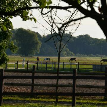
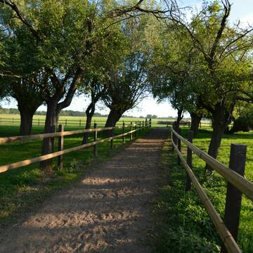
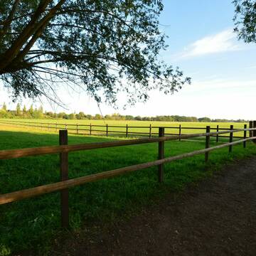
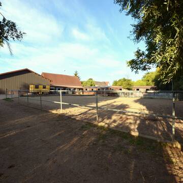
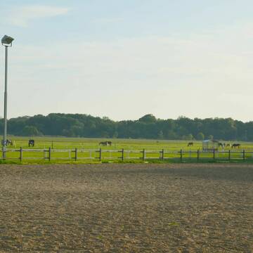
Reitstall in den traumhaften Saaleauen in Holleben
Holleben
Burghof-Holleben-UG-Co-KG
@Burghof-Holleben-UG-Co-KG
FN-Mitglied
Freizeitstall
Paddock
Reithalle
Innenbox
Vollpension
7 weitere...
aktuell
S
Deprecated: Creation of dynamic property Zend_View_Helper_Ads::$adLink is deprecated in /var/www/stall-frei/htdocs/staging.stall-frei.de/library/Psf/View/Helper/Ads.php on line 108

Das Beste für die Hufe
Mechtersen
STALL-FREIde Marketing
@STALL-FREI-Marketing
Hufschmiede und Hufpfleger in Ihrer Nähe
Leider kein Vorschaubild
Leider kein Vorschaubild
Für Pferd & Mensch Natur pur
Braunsbedra, Sachsen-Anhalt
RFFB e.V.
@Braunsbedra
Freizeitstall
Krankenbox
Longierzirkel/Roundpen
Halbpension
Einzelne Boxen oder Stallplätze
10 weitere...
B
Leider kein Vorschaubild
Leider kein Vorschaubild
im schönen Geiseltal
Braunsbedra, Sachsen-Anhalt
RFFB e.V.
@Braunsbedra
Freizeitstall
Krankenbox
Longierzirkel/Roundpen
Vollpension
Einzelne Boxen oder Stallplätze
9 weitere...
aktuell
B

Pensionsstall, Reitunterricht, Beritt, Schulpferde
Ilmtal-Weinstraße
Rosshof Becker
@Rosshof-Becker1
FN-Mitglied
Freizeitstall
Vermieten
Krankenbox
Longierzirkel/Roundpen
Fohlenaufzucht möglich
Hengsthaltung möglich
23 weitere...
P
Leider kein Vorschaubild
Leider kein Vorschaubild
Pferdeboxen frei
Weißenfels
Sigrun Fröhlich
@Equiemption
Freizeitstall
Pferdeausbildung
Vermieten
Hunde willkommen
Longierzirkel/Roundpen
Allergikerstall
bedampftes/gewaschenes Heu
21 weitere...
ganz aktuell
B
Leider kein Vorschaubild
Leider kein Vorschaubild
Offenstall Plätze
Weißenfels
Sigrun Fröhlich
@Equiemption
Freizeitstall
Pferdeausbildung
Vermieten
Hunde willkommen
Paddock
Allergikerstall
Fohlenaufzucht möglich
17 weitere...
aktuell
B
Leider kein Vorschaubild
Leider kein Vorschaubild
Reha-Boxen
Weißenfels
Sigrun Fröhlich
@Equiemption
Freizeitstall
Pferdeausbildung
Vermieten
Hunde willkommen
Longierzirkel/Roundpen
Allergikerstall
Fohlenaufzucht möglich
22 weitere...
B

Frisches Stroh zu verkaufen!
Mechtersen
STALL-FREIde Marketing
@STALL-FREI-Marketing
Kaufe frisches Stroh für dein Pferd!
Leider kein Vorschaubild
Leider kein Vorschaubild
Selbstversorgerbox
Weißenfels
Sigrun Fröhlich
@Equiemption
Vermieten
Hunde willkommen
Parkplatz für Pferdeanhänger
Allergikerstall
Hufrehe geeignet
Offenstall
8 weitere...
B
Leider kein Vorschaubild
Leider kein Vorschaubild
Aufzuchtsplätze
Weißenfels
Sigrun Fröhlich
@Equiemption
Freizeitstall
Reitlehrer und -unterricht
Vermieten
Hunde willkommen
Pensions- und Gastboxen
Allergikerstall
Fohlenaufzucht möglich
13 weitere...
B
Reiterhof
Groitzsch
Koehlerhof
@Koehlerhof
Freizeitstall
Longierzirkel/Roundpen
Paddock
Außenboxen
Innenbox
4 weitere...
P
Veröffentliche deine Suche als Gesuch und Suchauftrag, dann erhältst du Angebote, neue Treffer und Änderungen per E-Mail.
Diese Suche als Gesuch veröffentlichenDeprecated: Creation of dynamic property Zend_View::$pageCount is deprecated in /var/www/stall-frei/htdocs/staging.stall-frei.de/library/vendor/shardj/zf1-future/library/Zend/View/Abstract.php on line 308
Deprecated: Creation of dynamic property Zend_View::$itemCountPerPage is deprecated in /var/www/stall-frei/htdocs/staging.stall-frei.de/library/vendor/shardj/zf1-future/library/Zend/View/Abstract.php on line 308
Deprecated: Creation of dynamic property Zend_View::$first is deprecated in /var/www/stall-frei/htdocs/staging.stall-frei.de/library/vendor/shardj/zf1-future/library/Zend/View/Abstract.php on line 308
Deprecated: Creation of dynamic property Zend_View::$current is deprecated in /var/www/stall-frei/htdocs/staging.stall-frei.de/library/vendor/shardj/zf1-future/library/Zend/View/Abstract.php on line 308
Deprecated: Creation of dynamic property Zend_View::$last is deprecated in /var/www/stall-frei/htdocs/staging.stall-frei.de/library/vendor/shardj/zf1-future/library/Zend/View/Abstract.php on line 308
Deprecated: Creation of dynamic property Zend_View::$previous is deprecated in /var/www/stall-frei/htdocs/staging.stall-frei.de/library/vendor/shardj/zf1-future/library/Zend/View/Abstract.php on line 308
Deprecated: Creation of dynamic property Zend_View::$next is deprecated in /var/www/stall-frei/htdocs/staging.stall-frei.de/library/vendor/shardj/zf1-future/library/Zend/View/Abstract.php on line 308
Deprecated: Creation of dynamic property Zend_View::$pagesInRange is deprecated in /var/www/stall-frei/htdocs/staging.stall-frei.de/library/vendor/shardj/zf1-future/library/Zend/View/Abstract.php on line 308
Deprecated: Creation of dynamic property Zend_View::$firstPageInRange is deprecated in /var/www/stall-frei/htdocs/staging.stall-frei.de/library/vendor/shardj/zf1-future/library/Zend/View/Abstract.php on line 308
Deprecated: Creation of dynamic property Zend_View::$lastPageInRange is deprecated in /var/www/stall-frei/htdocs/staging.stall-frei.de/library/vendor/shardj/zf1-future/library/Zend/View/Abstract.php on line 308
Deprecated: Creation of dynamic property Zend_View::$currentItemCount is deprecated in /var/www/stall-frei/htdocs/staging.stall-frei.de/library/vendor/shardj/zf1-future/library/Zend/View/Abstract.php on line 308
Deprecated: Creation of dynamic property Zend_View::$totalItemCount is deprecated in /var/www/stall-frei/htdocs/staging.stall-frei.de/library/vendor/shardj/zf1-future/library/Zend/View/Abstract.php on line 308
Deprecated: Creation of dynamic property Zend_View::$firstItemNumber is deprecated in /var/www/stall-frei/htdocs/staging.stall-frei.de/library/vendor/shardj/zf1-future/library/Zend/View/Abstract.php on line 308
Deprecated: Creation of dynamic property Zend_View::$lastItemNumber is deprecated in /var/www/stall-frei/htdocs/staging.stall-frei.de/library/vendor/shardj/zf1-future/library/Zend/View/Abstract.php on line 308
Deprecated: Creation of dynamic property Zend_View::$router is deprecated in /var/www/stall-frei/htdocs/staging.stall-frei.de/library/vendor/shardj/zf1-future/library/Zend/View/Abstract.php on line 308
Deprecated: Creation of dynamic property Zend_View::$urlParams is deprecated in /var/www/stall-frei/htdocs/staging.stall-frei.de/library/vendor/shardj/zf1-future/library/Zend/View/Abstract.php on line 308
Deprecated: Creation of dynamic property Zend_View::$showAds is deprecated in /var/www/stall-frei/htdocs/staging.stall-frei.de/library/vendor/shardj/zf1-future/library/Zend/View/Abstract.php on line 308
Deprecated: Creation of dynamic property Zend_View::$objectIds is deprecated in /var/www/stall-frei/htdocs/staging.stall-frei.de/library/vendor/shardj/zf1-future/library/Zend/View/Abstract.php on line 308
Deprecated: Creation of dynamic property Zend_View::$showNavbar is deprecated in /var/www/stall-frei/htdocs/staging.stall-frei.de/library/vendor/shardj/zf1-future/library/Zend/View/Abstract.php on line 308
Deprecated: Creation of dynamic property Zend_View::$showBreadcrumb is deprecated in /var/www/stall-frei/htdocs/staging.stall-frei.de/library/vendor/shardj/zf1-future/library/Zend/View/Abstract.php on line 308
Deprecated: Creation of dynamic property Zend_View::$showFooter is deprecated in /var/www/stall-frei/htdocs/staging.stall-frei.de/library/vendor/shardj/zf1-future/library/Zend/View/Abstract.php on line 308
Deprecated: Creation of dynamic property Zend_View::$showInternalAds is deprecated in /var/www/stall-frei/htdocs/staging.stall-frei.de/library/vendor/shardj/zf1-future/library/Zend/View/Abstract.php on line 308
Deprecated: Creation of dynamic property Zend_View::$blNoContent is deprecated in /var/www/stall-frei/htdocs/staging.stall-frei.de/library/vendor/shardj/zf1-future/library/Zend/View/Abstract.php on line 308
Deprecated: Creation of dynamic property Zend_View::$sMetaDesc is deprecated in /var/www/stall-frei/htdocs/staging.stall-frei.de/library/vendor/shardj/zf1-future/library/Zend/View/Abstract.php on line 308
Deprecated: Creation of dynamic property Zend_View::$useGmaps is deprecated in /var/www/stall-frei/htdocs/staging.stall-frei.de/library/vendor/shardj/zf1-future/library/Zend/View/Abstract.php on line 308
Deprecated: Creation of dynamic property Zend_View::$touches is deprecated in /var/www/stall-frei/htdocs/staging.stall-frei.de/library/vendor/shardj/zf1-future/library/Zend/View/Abstract.php on line 308
Deprecated: Creation of dynamic property Zend_View::$oProject is deprecated in /var/www/stall-frei/htdocs/staging.stall-frei.de/library/vendor/shardj/zf1-future/library/Zend/View/Abstract.php on line 308
Deprecated: Creation of dynamic property Zend_View::$pageHeadline is deprecated in /var/www/stall-frei/htdocs/staging.stall-frei.de/library/vendor/shardj/zf1-future/library/Zend/View/Abstract.php on line 308
Deprecated: Creation of dynamic property Zend_View::$disableLocationField is deprecated in /var/www/stall-frei/htdocs/staging.stall-frei.de/library/vendor/shardj/zf1-future/library/Zend/View/Abstract.php on line 308
Deprecated: Creation of dynamic property Zend_View::$isSearch is deprecated in /var/www/stall-frei/htdocs/staging.stall-frei.de/library/vendor/shardj/zf1-future/library/Zend/View/Abstract.php on line 308
Deprecated: Creation of dynamic property Zend_View::$pageTitle is deprecated in /var/www/stall-frei/htdocs/staging.stall-frei.de/library/vendor/shardj/zf1-future/library/Zend/View/Abstract.php on line 308
Deprecated: Creation of dynamic property Psf_Form_Element_Text::$class is deprecated in /var/www/stall-frei/htdocs/staging.stall-frei.de/library/vendor/shardj/zf1-future/library/Zend/Form/Element.php on line 874
Deprecated: Creation of dynamic property Psf_Form_Element_Text::$size is deprecated in /var/www/stall-frei/htdocs/staging.stall-frei.de/library/vendor/shardj/zf1-future/library/Zend/Form/Element.php on line 874
Deprecated: Creation of dynamic property Psf_Form_Element_Text::$placeholder is deprecated in /var/www/stall-frei/htdocs/staging.stall-frei.de/library/vendor/shardj/zf1-future/library/Zend/Form/Element.php on line 874
Deprecated: Creation of dynamic property Psf_Form_Element_Hidden::$class is deprecated in /var/www/stall-frei/htdocs/staging.stall-frei.de/library/vendor/shardj/zf1-future/library/Zend/Form/Element.php on line 874
Deprecated: Creation of dynamic property Psf_Form_Element_Hidden::$class is deprecated in /var/www/stall-frei/htdocs/staging.stall-frei.de/library/vendor/shardj/zf1-future/library/Zend/Form/Element.php on line 874
Deprecated: Creation of dynamic property Psf_Form_Element_Hidden::$class is deprecated in /var/www/stall-frei/htdocs/staging.stall-frei.de/library/vendor/shardj/zf1-future/library/Zend/Form/Element.php on line 874
Deprecated: Creation of dynamic property Psf_Form_Element_Hidden::$class is deprecated in /var/www/stall-frei/htdocs/staging.stall-frei.de/library/vendor/shardj/zf1-future/library/Zend/Form/Element.php on line 874
Deprecated: Creation of dynamic property Psf_Form_Element_Select::$class is deprecated in /var/www/stall-frei/htdocs/staging.stall-frei.de/library/vendor/shardj/zf1-future/library/Zend/Form/Element.php on line 874
Deprecated: Creation of dynamic property Psf_Form_Element_Select::$class is deprecated in /var/www/stall-frei/htdocs/staging.stall-frei.de/library/vendor/shardj/zf1-future/library/Zend/Form/Element.php on line 874
Deprecated: Creation of dynamic property Psf_Form_Element_Select::$class is deprecated in /var/www/stall-frei/htdocs/staging.stall-frei.de/library/vendor/shardj/zf1-future/library/Zend/Form/Element.php on line 874
Deprecated: Creation of dynamic property Psf_Form_Element_Select::$class is deprecated in /var/www/stall-frei/htdocs/staging.stall-frei.de/library/vendor/shardj/zf1-future/library/Zend/Form/Element.php on line 874
Deprecated: Creation of dynamic property Psf_Form_Element_Text::$class is deprecated in /var/www/stall-frei/htdocs/staging.stall-frei.de/library/vendor/shardj/zf1-future/library/Zend/Form/Element.php on line 874
Deprecated: Creation of dynamic property Psf_Form_Element_Checkbox::$label is deprecated in /var/www/stall-frei/htdocs/staging.stall-frei.de/library/vendor/shardj/zf1-future/library/Zend/Form/Element.php on line 874
Deprecated: Creation of dynamic property Zend_View::$sort is deprecated in /var/www/stall-frei/htdocs/staging.stall-frei.de/library/vendor/shardj/zf1-future/library/Zend/View/Abstract.php on line 308
Deprecated: Creation of dynamic property Zend_View::$searchLocation is deprecated in /var/www/stall-frei/htdocs/staging.stall-frei.de/library/vendor/shardj/zf1-future/library/Zend/View/Abstract.php on line 308
Deprecated: Creation of dynamic property Zend_View::$locationHint is deprecated in /var/www/stall-frei/htdocs/staging.stall-frei.de/library/vendor/shardj/zf1-future/library/Zend/View/Abstract.php on line 308
Psf_GeoCoder_Abstract::getLocation: Utenbach Get Location CachedOrLive
Psf_GeoCoder_Abstract::getCachedOrLive: Utenbach
Psf_GeoCoder_Abstract::convertLocationResult
{"documentation":"https:\/\/opencagedata.com\/api","licenses":[{"name":"see attribution guide","url":"https:\/\/opencagedata.com\/credits"}],"results":[{"bounds":{"northeast":{"lat":51.0784121,"lng":11.8958426},"southwest":{"lat":51.0511838,"lng":11.8460793}},"components":{"ISO_3166-1_alpha-2":"DE","ISO_3166-1_alpha-3":"DEU","ISO_3166-2":["DE-ST"],"_category":"place","_normalized_city":"Utenbach","_type":"village","continent":"Europe","country":"Deutschland","country_code":"de","county":"Burgenlandkreis","municipality":"Wethautal","political_union":"European Union","state":"Sachsen-Anhalt","state_code":"ST","town":"Utenbach","village":"Mertendorf"},"confidence":7,"formatted":"Mertendorf, Sachsen-Anhalt, Deutschland","geometry":{"lat":51.0647996,"lng":11.858874}},{"bounds":{"northeast":{"lat":51.0485354,"lng":11.5819204},"southwest":{"lat":51.0085354,"lng":11.5419204}},"components":{"ISO_3166-1_alpha-2":"DE","ISO_3166-1_alpha-3":"DEU","ISO_3166-2":["DE-TH"],"_category":"place","_normalized_city":"Apolda","_type":"village","continent":"Europe","country":"Deutschland","country_code":"de","county":"Landkreis Weimarer Land","political_union":"European Union","postcode":"99510","state":"Th\u00fcringen","state_code":"TH","town":"Apolda","village":"Utenbach"},"confidence":7,"formatted":"99510 Utenbach, Deutschland","geometry":{"lat":51.0285354,"lng":11.5619204}},{"bounds":{"northeast":{"lat":51.0865894,"lng":11.8858564},"southwest":{"lat":51.0465894,"lng":11.8458564}},"components":{"ISO_3166-1_alpha-2":"DE","ISO_3166-1_alpha-3":"DEU","ISO_3166-2":["DE-ST"],"_category":"place","_normalized_city":"Mertendorf","_type":"village","city":"Mertendorf","continent":"Europe","country":"Deutschland","country_code":"de","county":"Burgenlandkreis","municipality":"Wethautal","political_union":"European Union","state":"Sachsen-Anhalt","state_code":"ST","village":"Utenbach"},"confidence":7,"formatted":"Utenbach, Sachsen-Anhalt, Deutschland","geometry":{"lat":51.0665894,"lng":11.8658564}},{"bounds":{"northeast":{"lat":51.0596647,"lng":11.5721902},"southwest":{"lat":51.0263015,"lng":11.5542259}},"components":{"ISO_3166-1_alpha-2":"DE","ISO_3166-1_alpha-3":"DEU","ISO_3166-2":["DE-TH"],"_category":"natural\/water","_normalized_city":"Apolda","_type":"stream","continent":"Europe","country":"Deutschland","country_code":"de","county":"Landkreis Weimarer Land","municipality":"Bad Sulza","political_union":"European Union","state":"Th\u00fcringen","state_code":"TH","stream":"Utenbach","town":"Apolda","village":"Flurstedt"},"confidence":7,"formatted":"Utenbach, Flurstedt, Th\u00fcringen, Deutschland","geometry":{"lat":51.0385714,"lng":11.5601304}},{"bounds":{"northeast":{"lat":51.0296563,"lng":11.591924},"southwest":{"lat":51.0272314,"lng":11.5807146}},"components":{"ISO_3166-1_alpha-2":"DE","ISO_3166-1_alpha-3":"DEU","ISO_3166-2":["DE-TH"],"_category":"natural\/water","_normalized_city":"Bad Sulza","_type":"stream","continent":"Europe","country":"Deutschland","country_code":"de","county":"Landkreis Weimarer Land","municipality":"Bad Sulza","political_union":"European Union","postcode":"99518","state":"Th\u00fcringen","state_code":"TH","stream":"Utenbach","town":"Bad Sulza","village":"Saaleplatte"},"confidence":9,"formatted":"Utenbach, 99518 Saaleplatte, Deutschland","geometry":{"lat":51.0288672,"lng":11.5863367}},{"bounds":{"northeast":{"lat":51.0263015,"lng":11.5723594},"southwest":{"lat":51.0262549,"lng":11.5721902}},"components":{"ISO_3166-1_alpha-2":"DE","ISO_3166-1_alpha-3":"DEU","ISO_3166-2":["DE-TH"],"_category":"natural\/water","_normalized_city":"Apolda","_type":"stream","continent":"Europe","country":"Deutschland","country_code":"de","county":"Landkreis Weimarer Land","political_union":"European Union","postcode":"99510","state":"Th\u00fcringen","state_code":"TH","stream":"Utenbach","town":"Apolda","village":"Utenbach"},"confidence":9,"formatted":"Utenbach, 99510 Utenbach, Deutschland","geometry":{"lat":51.0262782,"lng":11.5722748}},{"components":{"ISO_3166-1_alpha-2":"FR","ISO_3166-1_alpha-3":"FRA","ISO_3166-2":["FR-GES","FR-6AE","FR-68"],"_category":"road","_normalized_city":"Munster","_type":"road","city":"Munster","continent":"Europe","country":"France","country_code":"fr","county":"Haut-Rhin","local_authority":"Communaut\u00e9 de communes de la Vall\u00e9e de Munster","political_union":"European Union","postcode":"68140","road":"Rue de Luttenbach","state":"Grand Est","state_code":"GES"},"confidence":3,"formatted":"Rue de Luttenbach, 68140 Munster, France","geometry":{"lat":48.038929,"lng":7.126288}},{"components":{"ISO_3166-1_alpha-2":"FR","ISO_3166-1_alpha-3":"FRA","ISO_3166-2":["FR-GES","FR-6AE","FR-67"],"_category":"road","_normalized_city":"Breitenau","_type":"road","city":"Breitenau","continent":"Europe","country":"France","country_code":"fr","county":"Bas-Rhin","local_authority":"Communaut\u00e9 de communes de la Vall\u00e9e de Vill\u00e9","political_union":"European Union","postcode":"67220","road":"Rue de Luttenbach","state":"Grand Est","state_code":"GES"},"confidence":3,"formatted":"Rue de Luttenbach, 67220 Breitenau, France","geometry":{"lat":48.326569,"lng":7.293111}},{"components":{"ISO_3166-1_alpha-2":"FR","ISO_3166-1_alpha-3":"FRA","ISO_3166-2":["FR-GES","FR-6AE","FR-68"],"_category":"road","_normalized_city":"Muhlbach-sur-Munster","_type":"road","city":"Muhlbach-sur-Munster","continent":"Europe","country":"France","country_code":"fr","county":"Haut-Rhin","local_authority":"Communaut\u00e9 de communes de la Vall\u00e9e de Munster","political_union":"European Union","postcode":"68380","road":"Luttenbach","state":"Grand Est","state_code":"GES"},"confidence":3,"formatted":"Luttenbach, 68380 Muhlbach-sur-Munster, France","geometry":{"lat":48.029445,"lng":7.054841}},{"components":{"ISO_3166-1_alpha-2":"FR","ISO_3166-1_alpha-3":"FRA","ISO_3166-2":["FR-GES","FR-6AE","FR-67"],"_category":"road","_normalized_city":"Vill\u00e9","_type":"road","city":"Vill\u00e9","continent":"Europe","country":"France","country_code":"fr","county":"Bas-Rhin","local_authority":"Communaut\u00e9 de communes de la Vall\u00e9e de Vill\u00e9","political_union":"European Union","postcode":"67220","road":"Rue du Luttenbach","state":"Grand Est","state_code":"GES"},"confidence":3,"formatted":"Rue du Luttenbach, 67220 Vill\u00e9, France","geometry":{"lat":48.339087,"lng":7.306964}}],"status":{"code":200,"message":"OK"},"stay_informed":{"blog":"https:\/\/blog.opencagedata.com","mastodon":"https:\/\/en.osm.town\/@opencage"},"thanks":"For using an OpenCage API","timestamp":{"created_http":"Sun, 08 Feb 2026 20:20:50 GMT","created_unix":1770582050},"total_results":10}Array
(
[0] => stdClass Object
(
[bounds] => stdClass Object
(
[northeast] => stdClass Object
(
[lat] => 51.0784121
[lng] => 11.8958426
)
[southwest] => stdClass Object
(
[lat] => 51.0511838
[lng] => 11.8460793
)
)
[components] => stdClass Object
(
[ISO_3166-1_alpha-2] => DE
[ISO_3166-1_alpha-3] => DEU
[ISO_3166-2] => Array
(
[0] => DE-ST
)
[_category] => place
[_normalized_city] => Utenbach
[_type] => village
[continent] => Europe
[country] => Deutschland
[country_code] => de
[county] => Burgenlandkreis
[municipality] => Wethautal
[political_union] => European Union
[state] => Sachsen-Anhalt
[state_code] => ST
[town] => Utenbach
[village] => Mertendorf
)
[confidence] => 7
[formatted] => Mertendorf, Sachsen-Anhalt, Deutschland
[geometry] => stdClass Object
(
[lat] => 51.0647996
[lng] => 11.858874
)
)
[1] => stdClass Object
(
[bounds] => stdClass Object
(
[northeast] => stdClass Object
(
[lat] => 51.0485354
[lng] => 11.5819204
)
[southwest] => stdClass Object
(
[lat] => 51.0085354
[lng] => 11.5419204
)
)
[components] => stdClass Object
(
[ISO_3166-1_alpha-2] => DE
[ISO_3166-1_alpha-3] => DEU
[ISO_3166-2] => Array
(
[0] => DE-TH
)
[_category] => place
[_normalized_city] => Apolda
[_type] => village
[continent] => Europe
[country] => Deutschland
[country_code] => de
[county] => Landkreis Weimarer Land
[political_union] => European Union
[postcode] => 99510
[state] => Thüringen
[state_code] => TH
[town] => Apolda
[village] => Utenbach
)
[confidence] => 7
[formatted] => 99510 Utenbach, Deutschland
[geometry] => stdClass Object
(
[lat] => 51.0285354
[lng] => 11.5619204
)
)
[2] => stdClass Object
(
[bounds] => stdClass Object
(
[northeast] => stdClass Object
(
[lat] => 51.0865894
[lng] => 11.8858564
)
[southwest] => stdClass Object
(
[lat] => 51.0465894
[lng] => 11.8458564
)
)
[components] => stdClass Object
(
[ISO_3166-1_alpha-2] => DE
[ISO_3166-1_alpha-3] => DEU
[ISO_3166-2] => Array
(
[0] => DE-ST
)
[_category] => place
[_normalized_city] => Mertendorf
[_type] => village
[city] => Mertendorf
[continent] => Europe
[country] => Deutschland
[country_code] => de
[county] => Burgenlandkreis
[municipality] => Wethautal
[political_union] => European Union
[state] => Sachsen-Anhalt
[state_code] => ST
[village] => Utenbach
)
[confidence] => 7
[formatted] => Utenbach, Sachsen-Anhalt, Deutschland
[geometry] => stdClass Object
(
[lat] => 51.0665894
[lng] => 11.8658564
)
)
[3] => stdClass Object
(
[bounds] => stdClass Object
(
[northeast] => stdClass Object
(
[lat] => 51.0596647
[lng] => 11.5721902
)
[southwest] => stdClass Object
(
[lat] => 51.0263015
[lng] => 11.5542259
)
)
[components] => stdClass Object
(
[ISO_3166-1_alpha-2] => DE
[ISO_3166-1_alpha-3] => DEU
[ISO_3166-2] => Array
(
[0] => DE-TH
)
[_category] => natural/water
[_normalized_city] => Apolda
[_type] => stream
[continent] => Europe
[country] => Deutschland
[country_code] => de
[county] => Landkreis Weimarer Land
[municipality] => Bad Sulza
[political_union] => European Union
[state] => Thüringen
[state_code] => TH
[stream] => Utenbach
[town] => Apolda
[village] => Flurstedt
)
[confidence] => 7
[formatted] => Utenbach, Flurstedt, Thüringen, Deutschland
[geometry] => stdClass Object
(
[lat] => 51.0385714
[lng] => 11.5601304
)
)
[4] => stdClass Object
(
[bounds] => stdClass Object
(
[northeast] => stdClass Object
(
[lat] => 51.0296563
[lng] => 11.591924
)
[southwest] => stdClass Object
(
[lat] => 51.0272314
[lng] => 11.5807146
)
)
[components] => stdClass Object
(
[ISO_3166-1_alpha-2] => DE
[ISO_3166-1_alpha-3] => DEU
[ISO_3166-2] => Array
(
[0] => DE-TH
)
[_category] => natural/water
[_normalized_city] => Bad Sulza
[_type] => stream
[continent] => Europe
[country] => Deutschland
[country_code] => de
[county] => Landkreis Weimarer Land
[municipality] => Bad Sulza
[political_union] => European Union
[postcode] => 99518
[state] => Thüringen
[state_code] => TH
[stream] => Utenbach
[town] => Bad Sulza
[village] => Saaleplatte
)
[confidence] => 9
[formatted] => Utenbach, 99518 Saaleplatte, Deutschland
[geometry] => stdClass Object
(
[lat] => 51.0288672
[lng] => 11.5863367
)
)
[5] => stdClass Object
(
[bounds] => stdClass Object
(
[northeast] => stdClass Object
(
[lat] => 51.0263015
[lng] => 11.5723594
)
[southwest] => stdClass Object
(
[lat] => 51.0262549
[lng] => 11.5721902
)
)
[components] => stdClass Object
(
[ISO_3166-1_alpha-2] => DE
[ISO_3166-1_alpha-3] => DEU
[ISO_3166-2] => Array
(
[0] => DE-TH
)
[_category] => natural/water
[_normalized_city] => Apolda
[_type] => stream
[continent] => Europe
[country] => Deutschland
[country_code] => de
[county] => Landkreis Weimarer Land
[political_union] => European Union
[postcode] => 99510
[state] => Thüringen
[state_code] => TH
[stream] => Utenbach
[town] => Apolda
[village] => Utenbach
)
[confidence] => 9
[formatted] => Utenbach, 99510 Utenbach, Deutschland
[geometry] => stdClass Object
(
[lat] => 51.0262782
[lng] => 11.5722748
)
)
[6] => stdClass Object
(
[components] => stdClass Object
(
[ISO_3166-1_alpha-2] => FR
[ISO_3166-1_alpha-3] => FRA
[ISO_3166-2] => Array
(
[0] => FR-GES
[1] => FR-6AE
[2] => FR-68
)
[_category] => road
[_normalized_city] => Munster
[_type] => road
[city] => Munster
[continent] => Europe
[country] => France
[country_code] => fr
[county] => Haut-Rhin
[local_authority] => Communauté de communes de la Vallée de Munster
[political_union] => European Union
[postcode] => 68140
[road] => Rue de Luttenbach
[state] => Grand Est
[state_code] => GES
)
[confidence] => 3
[formatted] => Rue de Luttenbach, 68140 Munster, France
[geometry] => stdClass Object
(
[lat] => 48.038929
[lng] => 7.126288
)
)
[7] => stdClass Object
(
[components] => stdClass Object
(
[ISO_3166-1_alpha-2] => FR
[ISO_3166-1_alpha-3] => FRA
[ISO_3166-2] => Array
(
[0] => FR-GES
[1] => FR-6AE
[2] => FR-67
)
[_category] => road
[_normalized_city] => Breitenau
[_type] => road
[city] => Breitenau
[continent] => Europe
[country] => France
[country_code] => fr
[county] => Bas-Rhin
[local_authority] => Communauté de communes de la Vallée de Villé
[political_union] => European Union
[postcode] => 67220
[road] => Rue de Luttenbach
[state] => Grand Est
[state_code] => GES
)
[confidence] => 3
[formatted] => Rue de Luttenbach, 67220 Breitenau, France
[geometry] => stdClass Object
(
[lat] => 48.326569
[lng] => 7.293111
)
)
[8] => stdClass Object
(
[components] => stdClass Object
(
[ISO_3166-1_alpha-2] => FR
[ISO_3166-1_alpha-3] => FRA
[ISO_3166-2] => Array
(
[0] => FR-GES
[1] => FR-6AE
[2] => FR-68
)
[_category] => road
[_normalized_city] => Muhlbach-sur-Munster
[_type] => road
[city] => Muhlbach-sur-Munster
[continent] => Europe
[country] => France
[country_code] => fr
[county] => Haut-Rhin
[local_authority] => Communauté de communes de la Vallée de Munster
[political_union] => European Union
[postcode] => 68380
[road] => Luttenbach
[state] => Grand Est
[state_code] => GES
)
[confidence] => 3
[formatted] => Luttenbach, 68380 Muhlbach-sur-Munster, France
[geometry] => stdClass Object
(
[lat] => 48.029445
[lng] => 7.054841
)
)
[9] => stdClass Object
(
[components] => stdClass Object
(
[ISO_3166-1_alpha-2] => FR
[ISO_3166-1_alpha-3] => FRA
[ISO_3166-2] => Array
(
[0] => FR-GES
[1] => FR-6AE
[2] => FR-67
)
[_category] => road
[_normalized_city] => Villé
[_type] => road
[city] => Villé
[continent] => Europe
[country] => France
[country_code] => fr
[county] => Bas-Rhin
[local_authority] => Communauté de communes de la Vallée de Villé
[political_union] => European Union
[postcode] => 67220
[road] => Rue du Luttenbach
[state] => Grand Est
[state_code] => GES
)
[confidence] => 3
[formatted] => Rue du Luttenbach, 67220 Villé, France
[geometry] => stdClass Object
(
[lat] => 48.339087
[lng] => 7.306964
)
)
)
Psf_GeoCoder_OpenCageData::getKeyMap: 0
stdClass Object
(
    [bounds] => stdClass Object
        (
            [northeast] => stdClass Object
                (
                    [lat] => 51.0784121
                    [lng] => 11.8958426
                )

            [southwest] => stdClass Object
                (
                    [lat] => 51.0511838
                    [lng] => 11.8460793
                )

        )

    [components] => stdClass Object
        (
            [ISO_3166-1_alpha-2] => DE
            [ISO_3166-1_alpha-3] => DEU
            [ISO_3166-2] => Array
                (
                    [0] => DE-ST
                )

            [_category] => place
            [_normalized_city] => Utenbach
            [_type] => village
            [continent] => Europe
            [country] => Deutschland
            [country_code] => de
            [county] => Burgenlandkreis
            [municipality] => Wethautal
            [political_union] => European Union
            [state] => Sachsen-Anhalt
            [state_code] => ST
            [town] => Utenbach
            [village] => Mertendorf
        )

    [confidence] => 7
    [formatted] => Mertendorf, Sachsen-Anhalt, Deutschland
    [geometry] => stdClass Object
        (
            [lat] => 51.0647996
            [lng] => 11.858874
        )

)
Psf_GeoCoder_OpenCageData::getCounty: Burgenlandkreis
Psf_GeoCoder_OpenCageData::addMissingData REFETCH!
Array
(
    [address] => Mertendorf, Sachsen-Anhalt, Deutschland
    [type] => village
    [street] =>
    [city] => Utenbach
    [county] => Burgenlandkreis
    [state] => Sachsen-Anhalt
    [zip] =>
    [country] => Deutschland
    [suburb] =>
    [countrycode] => de
    [latitude] => 51.0647996
    [longitude] => 11.858874
    [accuracy] => 1
    [confidence] => 7
    [bounds] => stdClass Object
        (
            [northeast] => stdClass Object
                (
                    [lat] => 51.0784121
                    [lng] => 11.8958426
                )

            [southwest] => stdClass Object
                (
                    [lat] => 51.0511838
                    [lng] => 11.8460793
                )

        )

)
reformat!
Array
(
    [address] => Utenbach
    [type] => village
    [street] =>
    [city] => Utenbach
    [county] => Burgenlandkreis
    [state] => Sachsen-Anhalt
    [zip] =>
    [country] => Deutschland
    [suburb] =>
    [countrycode] => de
    [latitude] => 51.0647996
    [longitude] => 11.858874
    [accuracy] => 1
    [confidence] => 7
    [bounds] => stdClass Object
        (
            [northeast] => stdClass Object
                (
                    [lat] => 51.0784121
                    [lng] => 11.8958426
                )

            [southwest] => stdClass Object
                (
                    [lat] => 51.0511838
                    [lng] => 11.8460793
                )

        )

    [place] => Utenbach, Sachsen-Anhalt
    [hash] => 7c70b11a2b209313213cef442f700b94
)
Psf_GeoCoder_OpenCageData::getKeyMap: 1
stdClass Object
(
    [bounds] => stdClass Object
        (
            [northeast] => stdClass Object
                (
                    [lat] => 51.0485354
                    [lng] => 11.5819204
                )

            [southwest] => stdClass Object
                (
                    [lat] => 51.0085354
                    [lng] => 11.5419204
                )

        )

    [components] => stdClass Object
        (
            [ISO_3166-1_alpha-2] => DE
            [ISO_3166-1_alpha-3] => DEU
            [ISO_3166-2] => Array
                (
                    [0] => DE-TH
                )

            [_category] => place
            [_normalized_city] => Apolda
            [_type] => village
            [continent] => Europe
            [country] => Deutschland
            [country_code] => de
            [county] => Landkreis Weimarer Land
            [political_union] => European Union
            [postcode] => 99510
            [state] => Thüringen
            [state_code] => TH
            [town] => Apolda
            [village] => Utenbach
        )

    [confidence] => 7
    [formatted] => 99510 Utenbach, Deutschland
    [geometry] => stdClass Object
        (
            [lat] => 51.0285354
            [lng] => 11.5619204
        )

)
Psf_GeoCoder_OpenCageData::getCounty: Weimarer Land
Psf_GeoCoder_OpenCageData::addMissingData REFETCH!
Array
(
    [address] => 99510 Utenbach, Deutschland
    [type] => village
    [street] =>
    [city] => Apolda
    [county] => Weimarer Land
    [state] => Thüringen
    [zip] => 99510
    [country] => Deutschland
    [suburb] =>
    [countrycode] => de
    [latitude] => 51.0285354
    [longitude] => 11.5619204
    [accuracy] => 1
    [confidence] => 7
    [bounds] => stdClass Object
        (
            [northeast] => stdClass Object
                (
                    [lat] => 51.0485354
                    [lng] => 11.5819204
                )

            [southwest] => stdClass Object
                (
                    [lat] => 51.0085354
                    [lng] => 11.5419204
                )

        )

)
reformat!
Array
(
    [address] => 99510 Apolda
    [type] => village
    [street] =>
    [city] => Apolda
    [county] => Weimarer Land
    [state] => Thüringen
    [zip] => 99510
    [country] => Deutschland
    [suburb] =>
    [countrycode] => de
    [latitude] => 51.0285354
    [longitude] => 11.5619204
    [accuracy] => 1
    [confidence] => 7
    [bounds] => stdClass Object
        (
            [northeast] => stdClass Object
                (
                    [lat] => 51.0485354
                    [lng] => 11.5819204
                )

            [southwest] => stdClass Object
                (
                    [lat] => 51.0085354
                    [lng] => 11.5419204
                )

        )

    [place] => 99510 Apolda, Thüringen
    [hash] => 10d624b4e886f359d219fd52257124fa
)
Psf_GeoCoder_OpenCageData::getKeyMap: 2
stdClass Object
(
    [bounds] => stdClass Object
        (
            [northeast] => stdClass Object
                (
                    [lat] => 51.0865894
                    [lng] => 11.8858564
                )

            [southwest] => stdClass Object
                (
                    [lat] => 51.0465894
                    [lng] => 11.8458564
                )

        )

    [components] => stdClass Object
        (
            [ISO_3166-1_alpha-2] => DE
            [ISO_3166-1_alpha-3] => DEU
            [ISO_3166-2] => Array
                (
                    [0] => DE-ST
                )

            [_category] => place
            [_normalized_city] => Mertendorf
            [_type] => village
            [city] => Mertendorf
            [continent] => Europe
            [country] => Deutschland
            [country_code] => de
            [county] => Burgenlandkreis
            [municipality] => Wethautal
            [political_union] => European Union
            [state] => Sachsen-Anhalt
            [state_code] => ST
            [village] => Utenbach
        )

    [confidence] => 7
    [formatted] => Utenbach, Sachsen-Anhalt, Deutschland
    [geometry] => stdClass Object
        (
            [lat] => 51.0665894
            [lng] => 11.8658564
        )

)
Psf_GeoCoder_OpenCageData::getCounty: Burgenlandkreis
Psf_GeoCoder_OpenCageData::addMissingData REFETCH!
Array
(
    [address] => Utenbach, Sachsen-Anhalt, Deutschland
    [type] => village
    [street] =>
    [city] => Utenbach
    [county] => Burgenlandkreis
    [state] => Sachsen-Anhalt
    [zip] =>
    [country] => Deutschland
    [suburb] =>
    [countrycode] => de
    [latitude] => 51.0665894
    [longitude] => 11.8658564
    [accuracy] => 1
    [confidence] => 7
    [bounds] => stdClass Object
        (
            [northeast] => stdClass Object
                (
                    [lat] => 51.0865894
                    [lng] => 11.8858564
                )

            [southwest] => stdClass Object
                (
                    [lat] => 51.0465894
                    [lng] => 11.8458564
                )

        )

)
reformat!
Array
(
    [address] => Utenbach, Sachsen-Anhalt, Deutschland
    [type] => village
    [street] =>
    [city] => Utenbach
    [county] => Burgenlandkreis
    [state] => Sachsen-Anhalt
    [zip] =>
    [country] => Deutschland
    [suburb] =>
    [countrycode] => de
    [latitude] => 51.0665894
    [longitude] => 11.8658564
    [accuracy] => 1
    [confidence] => 7
    [bounds] => stdClass Object
        (
            [northeast] => stdClass Object
                (
                    [lat] => 51.0865894
                    [lng] => 11.8858564
                )

            [southwest] => stdClass Object
                (
                    [lat] => 51.0465894
                    [lng] => 11.8458564
                )

        )

    [place] => Utenbach, Sachsen-Anhalt
    [hash] => 7c70b11a2b209313213cef442f700b94
)
Psf_GeoCoder_OpenCageData::getKeyMap: 3
stdClass Object
(
    [bounds] => stdClass Object
        (
            [northeast] => stdClass Object
                (
                    [lat] => 51.0596647
                    [lng] => 11.5721902
                )

            [southwest] => stdClass Object
                (
                    [lat] => 51.0263015
                    [lng] => 11.5542259
                )

        )

    [components] => stdClass Object
        (
            [ISO_3166-1_alpha-2] => DE
            [ISO_3166-1_alpha-3] => DEU
            [ISO_3166-2] => Array
                (
                    [0] => DE-TH
                )

            [_category] => natural/water
            [_normalized_city] => Apolda
            [_type] => stream
            [continent] => Europe
            [country] => Deutschland
            [country_code] => de
            [county] => Landkreis Weimarer Land
            [municipality] => Bad Sulza
            [political_union] => European Union
            [state] => Thüringen
            [state_code] => TH
            [stream] => Utenbach
            [town] => Apolda
            [village] => Flurstedt
        )

    [confidence] => 7
    [formatted] => Utenbach, Flurstedt, Thüringen, Deutschland
    [geometry] => stdClass Object
        (
            [lat] => 51.0385714
            [lng] => 11.5601304
        )

)
Psf_GeoCoder_OpenCageData::getCounty: Weimarer Land
Psf_GeoCoder_OpenCageData::addMissingData REFETCH!
Array
(
    [address] => Utenbach, Flurstedt, Thüringen, Deutschland
    [type] => stream
    [street] =>
    [city] => Apolda
    [county] => Weimarer Land
    [state] => Thüringen
    [zip] =>
    [country] => Deutschland
    [suburb] =>
    [countrycode] => de
    [latitude] => 51.0385714
    [longitude] => 11.5601304
    [accuracy] => 1
    [confidence] => 7
    [bounds] => stdClass Object
        (
            [northeast] => stdClass Object
                (
                    [lat] => 51.0596647
                    [lng] => 11.5721902
                )

            [southwest] => stdClass Object
                (
                    [lat] => 51.0263015
                    [lng] => 11.5542259
                )

        )

)
reformat!
Array
(
    [address] => Apolda
    [type] => stream
    [street] =>
    [city] => Apolda
    [county] => Weimarer Land
    [state] => Thüringen
    [zip] =>
    [country] => Deutschland
    [suburb] =>
    [countrycode] => de
    [latitude] => 51.0385714
    [longitude] => 11.5601304
    [accuracy] => 1
    [confidence] => 7
    [bounds] => stdClass Object
        (
            [northeast] => stdClass Object
                (
                    [lat] => 51.0596647
                    [lng] => 11.5721902
                )

            [southwest] => stdClass Object
                (
                    [lat] => 51.0263015
                    [lng] => 11.5542259
                )

        )

    [place] => Apolda, Thüringen
    [hash] => 0a8cbc8e8fe0c4d2877aedb8d9d84afb
)
Psf_GeoCoder_OpenCageData::getKeyMap: 4
stdClass Object
(
    [bounds] => stdClass Object
        (
            [northeast] => stdClass Object
                (
                    [lat] => 51.0296563
                    [lng] => 11.591924
                )

            [southwest] => stdClass Object
                (
                    [lat] => 51.0272314
                    [lng] => 11.5807146
                )

        )

    [components] => stdClass Object
        (
            [ISO_3166-1_alpha-2] => DE
            [ISO_3166-1_alpha-3] => DEU
            [ISO_3166-2] => Array
                (
                    [0] => DE-TH
                )

            [_category] => natural/water
            [_normalized_city] => Bad Sulza
            [_type] => stream
            [continent] => Europe
            [country] => Deutschland
            [country_code] => de
            [county] => Landkreis Weimarer Land
            [municipality] => Bad Sulza
            [political_union] => European Union
            [postcode] => 99518
            [state] => Thüringen
            [state_code] => TH
            [stream] => Utenbach
            [town] => Bad Sulza
            [village] => Saaleplatte
        )

    [confidence] => 9
    [formatted] => Utenbach, 99518 Saaleplatte, Deutschland
    [geometry] => stdClass Object
        (
            [lat] => 51.0288672
            [lng] => 11.5863367
        )

)
Psf_GeoCoder_OpenCageData::getCounty: Weimarer Land
Psf_GeoCoder_OpenCageData::addMissingData REFETCH!
Array
(
    [address] => Utenbach, 99518 Saaleplatte, Deutschland
    [type] => stream
    [street] =>
    [city] => Bad Sulza
    [county] => Weimarer Land
    [state] => Thüringen
    [zip] => 99518
    [country] => Deutschland
    [suburb] =>
    [countrycode] => de
    [latitude] => 51.0288672
    [longitude] => 11.5863367
    [accuracy] => 1
    [confidence] => 9
    [bounds] => stdClass Object
        (
            [northeast] => stdClass Object
                (
                    [lat] => 51.0296563
                    [lng] => 11.591924
                )

            [southwest] => stdClass Object
                (
                    [lat] => 51.0272314
                    [lng] => 11.5807146
                )

        )

)
reformat!
Array
(
    [address] => 99518 Bad Sulza
    [type] => stream
    [street] =>
    [city] => Bad Sulza
    [county] => Weimarer Land
    [state] => Thüringen
    [zip] => 99518
    [country] => Deutschland
    [suburb] =>
    [countrycode] => de
    [latitude] => 51.0288672
    [longitude] => 11.5863367
    [accuracy] => 1
    [confidence] => 9
    [bounds] => stdClass Object
        (
            [northeast] => stdClass Object
                (
                    [lat] => 51.0296563
                    [lng] => 11.591924
                )

            [southwest] => stdClass Object
                (
                    [lat] => 51.0272314
                    [lng] => 11.5807146
                )

        )

    [place] => 99518 Bad Sulza, Thüringen
    [hash] => 458f102f2bf16f7a9a5f4397eb8410a6
)
Psf_GeoCoder_OpenCageData::getKeyMap: 5
stdClass Object
(
    [bounds] => stdClass Object
        (
            [northeast] => stdClass Object
                (
                    [lat] => 51.0263015
                    [lng] => 11.5723594
                )

            [southwest] => stdClass Object
                (
                    [lat] => 51.0262549
                    [lng] => 11.5721902
                )

        )

    [components] => stdClass Object
        (
            [ISO_3166-1_alpha-2] => DE
            [ISO_3166-1_alpha-3] => DEU
            [ISO_3166-2] => Array
                (
                    [0] => DE-TH
                )

            [_category] => natural/water
            [_normalized_city] => Apolda
            [_type] => stream
            [continent] => Europe
            [country] => Deutschland
            [country_code] => de
            [county] => Landkreis Weimarer Land
            [political_union] => European Union
            [postcode] => 99510
            [state] => Thüringen
            [state_code] => TH
            [stream] => Utenbach
            [town] => Apolda
            [village] => Utenbach
        )

    [confidence] => 9
    [formatted] => Utenbach, 99510 Utenbach, Deutschland
    [geometry] => stdClass Object
        (
            [lat] => 51.0262782
            [lng] => 11.5722748
        )

)
Psf_GeoCoder_OpenCageData::getCounty: Weimarer Land
Psf_GeoCoder_OpenCageData::addMissingData REFETCH!
Array
(
    [address] => Utenbach, 99510 Utenbach, Deutschland
    [type] => stream
    [street] =>
    [city] => Apolda
    [county] => Weimarer Land
    [state] => Thüringen
    [zip] => 99510
    [country] => Deutschland
    [suburb] =>
    [countrycode] => de
    [latitude] => 51.0262782
    [longitude] => 11.5722748
    [accuracy] => 1
    [confidence] => 9
    [bounds] => stdClass Object
        (
            [northeast] => stdClass Object
                (
                    [lat] => 51.0263015
                    [lng] => 11.5723594
                )

            [southwest] => stdClass Object
                (
                    [lat] => 51.0262549
                    [lng] => 11.5721902
                )

        )

)
reformat!
Array
(
    [address] => 99510 Apolda
    [type] => stream
    [street] =>
    [city] => Apolda
    [county] => Weimarer Land
    [state] => Thüringen
    [zip] => 99510
    [country] => Deutschland
    [suburb] =>
    [countrycode] => de
    [latitude] => 51.0262782
    [longitude] => 11.5722748
    [accuracy] => 1
    [confidence] => 9
    [bounds] => stdClass Object
        (
            [northeast] => stdClass Object
                (
                    [lat] => 51.0263015
                    [lng] => 11.5723594
                )

            [southwest] => stdClass Object
                (
                    [lat] => 51.0262549
                    [lng] => 11.5721902
                )

        )

    [place] => 99510 Apolda, Thüringen
    [hash] => 10d624b4e886f359d219fd52257124fa
)
Psf_GeoCoder_OpenCageData::getKeyMap: 6
stdClass Object
(
    [components] => stdClass Object
        (
            [ISO_3166-1_alpha-2] => FR
            [ISO_3166-1_alpha-3] => FRA
            [ISO_3166-2] => Array
                (
                    [0] => FR-GES
                    [1] => FR-6AE
                    [2] => FR-68
                )

            [_category] => road
            [_normalized_city] => Munster
            [_type] => road
            [city] => Munster
            [continent] => Europe
            [country] => France
            [country_code] => fr
            [county] => Haut-Rhin
            [local_authority] => Communauté de communes de la Vallée de Munster
            [political_union] => European Union
            [postcode] => 68140
            [road] => Rue de Luttenbach
            [state] => Grand Est
            [state_code] => GES
        )

    [confidence] => 3
    [formatted] => Rue de Luttenbach, 68140 Munster, France
    [geometry] => stdClass Object
        (
            [lat] => 48.038929
            [lng] => 7.126288
        )

)
Psf_GeoCoder_OpenCageData::getCounty: Haut-Rhin
Psf_GeoCoder_OpenCageData::addMissingData REFETCH!
Array
(
    [address] => Rue de Luttenbach, 68140 Munster, France
    [type] => road
    [street] => Rue de Luttenbach
    [city] => Munster
    [county] => Haut-Rhin
    [state] => Grand Est
    [zip] => 68140
    [country] => France
    [suburb] =>
    [countrycode] => fr
    [latitude] => 48.038929
    [longitude] => 7.126288
    [accuracy] => 1
    [confidence] => 3
    [bounds] =>
)
reformat!
Array
(
    [address] => Rue de Luttenbach, 68140 Munster, France
    [type] => road
    [street] => Rue de Luttenbach
    [city] => Munster
    [county] => Haut-Rhin
    [state] => Grand Est
    [zip] => 68140
    [country] => France
    [suburb] =>
    [countrycode] => fr
    [latitude] => 48.038929
    [longitude] => 7.126288
    [accuracy] => 1
    [confidence] => 3
    [bounds] =>
    [place] => Rue de Luttenbach, 68140 Munster, Grand Est
    [hash] => c82fa761a85fbe08ffb2b175884d53fa
)
Psf_GeoCoder_OpenCageData::getKeyMap: 7
stdClass Object
(
    [components] => stdClass Object
        (
            [ISO_3166-1_alpha-2] => FR
            [ISO_3166-1_alpha-3] => FRA
            [ISO_3166-2] => Array
                (
                    [0] => FR-GES
                    [1] => FR-6AE
                    [2] => FR-67
                )

            [_category] => road
            [_normalized_city] => Breitenau
            [_type] => road
            [city] => Breitenau
            [continent] => Europe
            [country] => France
            [country_code] => fr
            [county] => Bas-Rhin
            [local_authority] => Communauté de communes de la Vallée de Villé
            [political_union] => European Union
            [postcode] => 67220
            [road] => Rue de Luttenbach
            [state] => Grand Est
            [state_code] => GES
        )

    [confidence] => 3
    [formatted] => Rue de Luttenbach, 67220 Breitenau, France
    [geometry] => stdClass Object
        (
            [lat] => 48.326569
            [lng] => 7.293111
        )

)
Psf_GeoCoder_OpenCageData::getCounty: Bas-Rhin
Psf_GeoCoder_OpenCageData::addMissingData REFETCH!
Array
(
    [address] => Rue de Luttenbach, 67220 Breitenau, France
    [type] => road
    [street] => Rue de Luttenbach
    [city] => Breitenau
    [county] => Bas-Rhin
    [state] => Grand Est
    [zip] => 67220
    [country] => France
    [suburb] =>
    [countrycode] => fr
    [latitude] => 48.326569
    [longitude] => 7.293111
    [accuracy] => 1
    [confidence] => 3
    [bounds] =>
)
reformat!
Array
(
    [address] => Rue de Luttenbach, 67220 Breitenau, France
    [type] => road
    [street] => Rue de Luttenbach
    [city] => Breitenau
    [county] => Bas-Rhin
    [state] => Grand Est
    [zip] => 67220
    [country] => France
    [suburb] =>
    [countrycode] => fr
    [latitude] => 48.326569
    [longitude] => 7.293111
    [accuracy] => 1
    [confidence] => 3
    [bounds] =>
    [place] => Rue de Luttenbach, 67220 Breitenau, Grand Est
    [hash] => 6735dcfef72dfb40b4974a1d8a62b68b
)
Psf_GeoCoder_OpenCageData::getKeyMap: 8
stdClass Object
(
    [components] => stdClass Object
        (
            [ISO_3166-1_alpha-2] => FR
            [ISO_3166-1_alpha-3] => FRA
            [ISO_3166-2] => Array
                (
                    [0] => FR-GES
                    [1] => FR-6AE
                    [2] => FR-68
                )

            [_category] => road
            [_normalized_city] => Muhlbach-sur-Munster
            [_type] => road
            [city] => Muhlbach-sur-Munster
            [continent] => Europe
            [country] => France
            [country_code] => fr
            [county] => Haut-Rhin
            [local_authority] => Communauté de communes de la Vallée de Munster
            [political_union] => European Union
            [postcode] => 68380
            [road] => Luttenbach
            [state] => Grand Est
            [state_code] => GES
        )

    [confidence] => 3
    [formatted] => Luttenbach, 68380 Muhlbach-sur-Munster, France
    [geometry] => stdClass Object
        (
            [lat] => 48.029445
            [lng] => 7.054841
        )

)
Psf_GeoCoder_OpenCageData::getCounty: Haut-Rhin
Psf_GeoCoder_OpenCageData::addMissingData REFETCH!
Array
(
    [address] => Luttenbach, 68380 Muhlbach-sur-Munster, France
    [type] => road
    [street] => Luttenbach
    [city] => Muhlbach-sur-Munster
    [county] => Haut-Rhin
    [state] => Grand Est
    [zip] => 68380
    [country] => France
    [suburb] =>
    [countrycode] => fr
    [latitude] => 48.029445
    [longitude] => 7.054841
    [accuracy] => 1
    [confidence] => 3
    [bounds] =>
)
reformat!
Array
(
    [address] => Luttenbach, 68380 Muhlbach-sur-Munster, France
    [type] => road
    [street] => Luttenbach
    [city] => Muhlbach-sur-Munster
    [county] => Haut-Rhin
    [state] => Grand Est
    [zip] => 68380
    [country] => France
    [suburb] =>
    [countrycode] => fr
    [latitude] => 48.029445
    [longitude] => 7.054841
    [accuracy] => 1
    [confidence] => 3
    [bounds] =>
    [place] => Luttenbach, 68380 Muhlbach-sur-Munster, Grand Est
    [hash] => 789f83b08e324c08713419b78fa7adc8
)
Psf_GeoCoder_OpenCageData::getKeyMap: 9
stdClass Object
(
    [components] => stdClass Object
        (
            [ISO_3166-1_alpha-2] => FR
            [ISO_3166-1_alpha-3] => FRA
            [ISO_3166-2] => Array
                (
                    [0] => FR-GES
                    [1] => FR-6AE
                    [2] => FR-67
                )

            [_category] => road
            [_normalized_city] => Villé
            [_type] => road
            [city] => Villé
            [continent] => Europe
            [country] => France
            [country_code] => fr
            [county] => Bas-Rhin
            [local_authority] => Communauté de communes de la Vallée de Villé
            [political_union] => European Union
            [postcode] => 67220
            [road] => Rue du Luttenbach
            [state] => Grand Est
            [state_code] => GES
        )

    [confidence] => 3
    [formatted] => Rue du Luttenbach, 67220 Villé, France
    [geometry] => stdClass Object
        (
            [lat] => 48.339087
            [lng] => 7.306964
        )

)
Psf_GeoCoder_OpenCageData::getCounty: Bas-Rhin
Psf_GeoCoder_OpenCageData::addMissingData REFETCH!
Array
(
    [address] => Rue du Luttenbach, 67220 Villé, France
    [type] => road
    [street] => Rue du Luttenbach
    [city] => Villé
    [county] => Bas-Rhin
    [state] => Grand Est
    [zip] => 67220
    [country] => France
    [suburb] =>
    [countrycode] => fr
    [latitude] => 48.339087
    [longitude] => 7.306964
    [accuracy] => 1
    [confidence] => 3
    [bounds] =>
)
reformat!
Array
(
    [address] => Rue du Luttenbach, 67220 Villé, France
    [type] => road
    [street] => Rue du Luttenbach
    [city] => Villé
    [county] => Bas-Rhin
    [state] => Grand Est
    [zip] => 67220
    [country] => France
    [suburb] =>
    [countrycode] => fr
    [latitude] => 48.339087
    [longitude] => 7.306964
    [accuracy] => 1
    [confidence] => 3
    [bounds] =>
    [place] => Rue du Luttenbach, 67220 Villé, Grand Est
    [hash] => dd93089f4e446cc24ee854dd76ea0675
)
Deprecated: Creation of dynamic property Zend_View::$locationHintStyle is deprecated in /var/www/stall-frei/htdocs/staging.stall-frei.de/library/vendor/shardj/zf1-future/library/Zend/View/Abstract.php on line 308
Deprecated: Creation of dynamic property Zend_View::$adGeoLocation is deprecated in /var/www/stall-frei/htdocs/staging.stall-frei.de/library/vendor/shardj/zf1-future/library/Zend/View/Abstract.php on line 308
Deprecated: Creation of dynamic property Zend_View::$recordCount is deprecated in /var/www/stall-frei/htdocs/staging.stall-frei.de/library/vendor/shardj/zf1-future/library/Zend/View/Abstract.php on line 308
Deprecated: Creation of dynamic property Zend_View::$paginationParams is deprecated in /var/www/stall-frei/htdocs/staging.stall-frei.de/library/vendor/shardj/zf1-future/library/Zend/View/Abstract.php on line 308
Deprecated: Creation of dynamic property Zend_View::$objectPaginator is deprecated in /var/www/stall-frei/htdocs/staging.stall-frei.de/library/vendor/shardj/zf1-future/library/Zend/View/Abstract.php on line 308
Deprecated: Creation of dynamic property Zend_View::$featuredObjects is deprecated in /var/www/stall-frei/htdocs/staging.stall-frei.de/library/vendor/shardj/zf1-future/library/Zend/View/Abstract.php on line 308
Deprecated: Creation of dynamic property Zend_View::$hints is deprecated in /var/www/stall-frei/htdocs/staging.stall-frei.de/library/vendor/shardj/zf1-future/library/Zend/View/Abstract.php on line 308
Deprecated: Creation of dynamic property Zend_View::$attributeHints is deprecated in /var/www/stall-frei/htdocs/staging.stall-frei.de/library/vendor/shardj/zf1-future/library/Zend/View/Abstract.php on line 308
Deprecated: Creation of dynamic property Zend_View::$oSearchForm is deprecated in /var/www/stall-frei/htdocs/staging.stall-frei.de/library/vendor/shardj/zf1-future/library/Zend/View/Abstract.php on line 308