Deprecated: Creation of dynamic property Zend_View::$sMode is deprecated in /var/www/stall-frei/htdocs/staging.stall-frei.de/library/vendor/shardj/zf1-future/library/Zend/View/Abstract.php on line 308
Stallplatz oder Offenstall in Hesel
Gesucht wird in "26835 Hesel, Deutschland"
6.359 Einträge
Deprecated: Creation of dynamic property Zend_View::$listObjects is deprecated in /var/www/stall-frei/htdocs/staging.stall-frei.de/library/vendor/shardj/zf1-future/library/Zend/View/Abstract.php on line 308
Gesponsort


Deprecated: Creation of dynamic property Zend_View::$listMode is deprecated in /var/www/stall-frei/htdocs/staging.stall-frei.de/library/vendor/shardj/zf1-future/library/Zend/View/Abstract.php on line 308
Deprecated: Creation of dynamic property Zend_View::$renderedObjects is deprecated in /var/www/stall-frei/htdocs/staging.stall-frei.de/library/vendor/shardj/zf1-future/library/Zend/View/Abstract.php on line 308
Deprecated: Creation of dynamic property Zend_View::$index is deprecated in /var/www/stall-frei/htdocs/staging.stall-frei.de/library/vendor/shardj/zf1-future/library/Zend/View/Abstract.php on line 308
Deprecated: Creation of dynamic property Zend_View::$displayMode is deprecated in /var/www/stall-frei/htdocs/staging.stall-frei.de/library/vendor/shardj/zf1-future/library/Zend/View/Abstract.php on line 308
Deprecated: Creation of dynamic property Zend_View::$remarketingIds is deprecated in /var/www/stall-frei/htdocs/staging.stall-frei.de/library/vendor/shardj/zf1-future/library/Zend/View/Abstract.php on line 308
Deprecated: Creation of dynamic property Zend_View::$listItem is deprecated in /var/www/stall-frei/htdocs/staging.stall-frei.de/library/vendor/shardj/zf1-future/library/Zend/View/Abstract.php on line 308
Deprecated: Creation of dynamic property Zend_View::$object is deprecated in /var/www/stall-frei/htdocs/staging.stall-frei.de/library/vendor/shardj/zf1-future/library/Zend/View/Abstract.php on line 308
Deprecated: Creation of dynamic property Zend_View::$attributes is deprecated in /var/www/stall-frei/htdocs/staging.stall-frei.de/library/vendor/shardj/zf1-future/library/Zend/View/Abstract.php on line 308
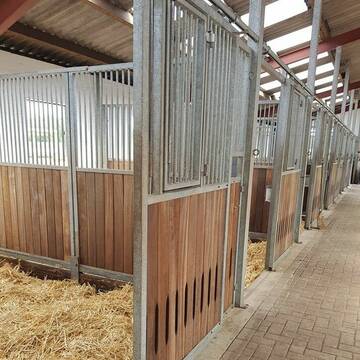
Pferdebox Paddockbox Fensterbox frei
Westerstede
Ebkenhof Reit-undPensionsstall
@Ebkenhof
FN-Mitglied
Freizeitstall
Vermieten
Verpachten
Hunde willkommen
Krankenbox
Allergikerstall
Gnadenbrothof
28 weitere...
P
Deprecated: Creation of dynamic property Zend_View_Helper_Ads::$adLink is deprecated in /var/www/stall-frei/htdocs/staging.stall-frei.de/library/Psf/View/Helper/Ads.php on line 108

Futtersack HeuToy, Fressbremse in pink
Mechtersen
STALL-FREIde Marketing
@STALL-FREI-Marketing
Stundenlange Beschäftigung die
Koliken vorbeugt, geringe Staubinhalation mit
steuerbarer Futterentnahme
Leider kein Vorschaubild
Leider kein Vorschaubild
Große Paddockbox
Großefehn
Astrid Goljat
@Oakland_Farm
Freizeitstall
VFD-Mitglied
Vermieten
Paddock
Pensions- und Gastboxen
Allergikerstall
8 weitere...
B

Hof ShaBaLi zeitgesteuerte Fütterung
Westerstede
Mellie Wempen-Grave
@HofShaBaLi
Freizeitstall
Rehabilitationsstall
Vermieten
Hunde willkommen
Krankenbox
Allergikerstall
bedampftes/gewaschenes Heu
18 weitere...
ganz aktuell
P
Leider kein Vorschaubild
Leider kein Vorschaubild
Offenstall,bel. Reitplatz,140€,Heulage,3ha Weide
Großefehn
Sabrina
@Mie_87
Freizeitstall
Vermieten
Krankenbox
Paddock
Allergikerstall
Notfallboxen
7 weitere...
B

2 Aufzuchtplätze frei
Rhauderfehn
Jamy-lee Willms
@DasPferdemeadchen
Freizeitstall
Fohlenaufzucht möglich
Innenbox
Laufbox
Vollpension
1 weitere...
P
Leider kein Vorschaubild
Leider kein Vorschaubild
Pferdebox frei in kleiner Stallgemeinschaft
Ihlow
Heiner Pollmann
@Heiner_Pollmann
Freizeitstall
Vermieten
Hunde willkommen
Paddock
Fohlenaufzucht möglich
Hufrehe geeignet
10 weitere...
aktuell
B
Paddock Trail,Allergiker,Kur,Aufzucht,Ausbilung
Westerstede-Mansie
Pferdehof-Mansie
@Pferdehof-Mansie
Freizeitstall
Pferdeausbildung
Vermieten
Hunde willkommen
Krankenbox
Allergikerstall
Hufrehe geeignet
23 weitere...
P

Heu und Heulage verkaufen
Mechtersen
STALL-FREIde Marketing
@STALL-FREI-Marketing
Verkaufen Sie Ihr Heu und Ihre Heulage direkt an Reiter, Pferdeställe und Reitanlagen
Leider kein Vorschaubild
Leider kein Vorschaubild
Tolle Helle Pferdeboxen auf privater Reitanlage
Friedeburg
ReitsportFriedeburg
@RPFReitsportFriedeburg
Freizeitstall
Pferdeausbildung
Vermieten
Führanlage
Krankenbox
Allergikerstall
bedampftes/gewaschenes Heu
26 weitere...
B
Leider kein Vorschaubild
Leider kein Vorschaubild
Offenstallplatz/Rentnerplatz
Rhauderfehn
Bianca
@Rose1989
Freizeitstall
Hunde willkommen
Paddock
Hufrehe geeignet
Notfallboxen
Offenstall
8 weitere...
B
Leider kein Vorschaubild
Leider kein Vorschaubild
Offenstallplatz/Rentnerplatz
Rhauderfehn
Bianca
@Rose1989
Freizeitstall
Hunde willkommen
Krankenbox
Hufrehe geeignet
Notfallboxen
Offenstall
Paddock Trail
11 weitere...
B
Veröffentliche deine Suche als Gesuch und Suchauftrag, dann erhältst du Angebote, neue Treffer und Änderungen per E-Mail.
Diese Suche als Gesuch veröffentlichenDeprecated: Creation of dynamic property Zend_View::$pageCount is deprecated in /var/www/stall-frei/htdocs/staging.stall-frei.de/library/vendor/shardj/zf1-future/library/Zend/View/Abstract.php on line 308
Deprecated: Creation of dynamic property Zend_View::$itemCountPerPage is deprecated in /var/www/stall-frei/htdocs/staging.stall-frei.de/library/vendor/shardj/zf1-future/library/Zend/View/Abstract.php on line 308
Deprecated: Creation of dynamic property Zend_View::$first is deprecated in /var/www/stall-frei/htdocs/staging.stall-frei.de/library/vendor/shardj/zf1-future/library/Zend/View/Abstract.php on line 308
Deprecated: Creation of dynamic property Zend_View::$current is deprecated in /var/www/stall-frei/htdocs/staging.stall-frei.de/library/vendor/shardj/zf1-future/library/Zend/View/Abstract.php on line 308
Deprecated: Creation of dynamic property Zend_View::$last is deprecated in /var/www/stall-frei/htdocs/staging.stall-frei.de/library/vendor/shardj/zf1-future/library/Zend/View/Abstract.php on line 308
Deprecated: Creation of dynamic property Zend_View::$previous is deprecated in /var/www/stall-frei/htdocs/staging.stall-frei.de/library/vendor/shardj/zf1-future/library/Zend/View/Abstract.php on line 308
Deprecated: Creation of dynamic property Zend_View::$next is deprecated in /var/www/stall-frei/htdocs/staging.stall-frei.de/library/vendor/shardj/zf1-future/library/Zend/View/Abstract.php on line 308
Deprecated: Creation of dynamic property Zend_View::$pagesInRange is deprecated in /var/www/stall-frei/htdocs/staging.stall-frei.de/library/vendor/shardj/zf1-future/library/Zend/View/Abstract.php on line 308
Deprecated: Creation of dynamic property Zend_View::$firstPageInRange is deprecated in /var/www/stall-frei/htdocs/staging.stall-frei.de/library/vendor/shardj/zf1-future/library/Zend/View/Abstract.php on line 308
Deprecated: Creation of dynamic property Zend_View::$lastPageInRange is deprecated in /var/www/stall-frei/htdocs/staging.stall-frei.de/library/vendor/shardj/zf1-future/library/Zend/View/Abstract.php on line 308
Deprecated: Creation of dynamic property Zend_View::$currentItemCount is deprecated in /var/www/stall-frei/htdocs/staging.stall-frei.de/library/vendor/shardj/zf1-future/library/Zend/View/Abstract.php on line 308
Deprecated: Creation of dynamic property Zend_View::$totalItemCount is deprecated in /var/www/stall-frei/htdocs/staging.stall-frei.de/library/vendor/shardj/zf1-future/library/Zend/View/Abstract.php on line 308
Deprecated: Creation of dynamic property Zend_View::$firstItemNumber is deprecated in /var/www/stall-frei/htdocs/staging.stall-frei.de/library/vendor/shardj/zf1-future/library/Zend/View/Abstract.php on line 308
Deprecated: Creation of dynamic property Zend_View::$lastItemNumber is deprecated in /var/www/stall-frei/htdocs/staging.stall-frei.de/library/vendor/shardj/zf1-future/library/Zend/View/Abstract.php on line 308
Deprecated: Creation of dynamic property Zend_View::$router is deprecated in /var/www/stall-frei/htdocs/staging.stall-frei.de/library/vendor/shardj/zf1-future/library/Zend/View/Abstract.php on line 308
Deprecated: Creation of dynamic property Zend_View::$urlParams is deprecated in /var/www/stall-frei/htdocs/staging.stall-frei.de/library/vendor/shardj/zf1-future/library/Zend/View/Abstract.php on line 308
Deprecated: Creation of dynamic property Zend_View::$showAds is deprecated in /var/www/stall-frei/htdocs/staging.stall-frei.de/library/vendor/shardj/zf1-future/library/Zend/View/Abstract.php on line 308
Deprecated: Creation of dynamic property Zend_View::$objectIds is deprecated in /var/www/stall-frei/htdocs/staging.stall-frei.de/library/vendor/shardj/zf1-future/library/Zend/View/Abstract.php on line 308
Deprecated: Creation of dynamic property Zend_View::$showNavbar is deprecated in /var/www/stall-frei/htdocs/staging.stall-frei.de/library/vendor/shardj/zf1-future/library/Zend/View/Abstract.php on line 308
Deprecated: Creation of dynamic property Zend_View::$showBreadcrumb is deprecated in /var/www/stall-frei/htdocs/staging.stall-frei.de/library/vendor/shardj/zf1-future/library/Zend/View/Abstract.php on line 308
Deprecated: Creation of dynamic property Zend_View::$showFooter is deprecated in /var/www/stall-frei/htdocs/staging.stall-frei.de/library/vendor/shardj/zf1-future/library/Zend/View/Abstract.php on line 308
Deprecated: Creation of dynamic property Zend_View::$showInternalAds is deprecated in /var/www/stall-frei/htdocs/staging.stall-frei.de/library/vendor/shardj/zf1-future/library/Zend/View/Abstract.php on line 308
Deprecated: Creation of dynamic property Zend_View::$blNoContent is deprecated in /var/www/stall-frei/htdocs/staging.stall-frei.de/library/vendor/shardj/zf1-future/library/Zend/View/Abstract.php on line 308
Deprecated: Creation of dynamic property Zend_View::$sMetaDesc is deprecated in /var/www/stall-frei/htdocs/staging.stall-frei.de/library/vendor/shardj/zf1-future/library/Zend/View/Abstract.php on line 308
Deprecated: Creation of dynamic property Zend_View::$useGmaps is deprecated in /var/www/stall-frei/htdocs/staging.stall-frei.de/library/vendor/shardj/zf1-future/library/Zend/View/Abstract.php on line 308
Deprecated: Creation of dynamic property Zend_View::$touches is deprecated in /var/www/stall-frei/htdocs/staging.stall-frei.de/library/vendor/shardj/zf1-future/library/Zend/View/Abstract.php on line 308
Deprecated: Creation of dynamic property Zend_View::$oProject is deprecated in /var/www/stall-frei/htdocs/staging.stall-frei.de/library/vendor/shardj/zf1-future/library/Zend/View/Abstract.php on line 308
Deprecated: Creation of dynamic property Zend_View::$pageHeadline is deprecated in /var/www/stall-frei/htdocs/staging.stall-frei.de/library/vendor/shardj/zf1-future/library/Zend/View/Abstract.php on line 308
Deprecated: Creation of dynamic property Zend_View::$disableLocationField is deprecated in /var/www/stall-frei/htdocs/staging.stall-frei.de/library/vendor/shardj/zf1-future/library/Zend/View/Abstract.php on line 308
Deprecated: Creation of dynamic property Zend_View::$isSearch is deprecated in /var/www/stall-frei/htdocs/staging.stall-frei.de/library/vendor/shardj/zf1-future/library/Zend/View/Abstract.php on line 308
Deprecated: Creation of dynamic property Zend_View::$pageTitle is deprecated in /var/www/stall-frei/htdocs/staging.stall-frei.de/library/vendor/shardj/zf1-future/library/Zend/View/Abstract.php on line 308
Deprecated: Creation of dynamic property Psf_Form_Element_Text::$class is deprecated in /var/www/stall-frei/htdocs/staging.stall-frei.de/library/vendor/shardj/zf1-future/library/Zend/Form/Element.php on line 874
Deprecated: Creation of dynamic property Psf_Form_Element_Text::$size is deprecated in /var/www/stall-frei/htdocs/staging.stall-frei.de/library/vendor/shardj/zf1-future/library/Zend/Form/Element.php on line 874
Deprecated: Creation of dynamic property Psf_Form_Element_Text::$placeholder is deprecated in /var/www/stall-frei/htdocs/staging.stall-frei.de/library/vendor/shardj/zf1-future/library/Zend/Form/Element.php on line 874
Deprecated: Creation of dynamic property Psf_Form_Element_Hidden::$class is deprecated in /var/www/stall-frei/htdocs/staging.stall-frei.de/library/vendor/shardj/zf1-future/library/Zend/Form/Element.php on line 874
Deprecated: Creation of dynamic property Psf_Form_Element_Hidden::$class is deprecated in /var/www/stall-frei/htdocs/staging.stall-frei.de/library/vendor/shardj/zf1-future/library/Zend/Form/Element.php on line 874
Deprecated: Creation of dynamic property Psf_Form_Element_Hidden::$class is deprecated in /var/www/stall-frei/htdocs/staging.stall-frei.de/library/vendor/shardj/zf1-future/library/Zend/Form/Element.php on line 874
Deprecated: Creation of dynamic property Psf_Form_Element_Hidden::$class is deprecated in /var/www/stall-frei/htdocs/staging.stall-frei.de/library/vendor/shardj/zf1-future/library/Zend/Form/Element.php on line 874
Deprecated: Creation of dynamic property Psf_Form_Element_Select::$class is deprecated in /var/www/stall-frei/htdocs/staging.stall-frei.de/library/vendor/shardj/zf1-future/library/Zend/Form/Element.php on line 874
Deprecated: Creation of dynamic property Psf_Form_Element_Select::$class is deprecated in /var/www/stall-frei/htdocs/staging.stall-frei.de/library/vendor/shardj/zf1-future/library/Zend/Form/Element.php on line 874
Deprecated: Creation of dynamic property Psf_Form_Element_Select::$class is deprecated in /var/www/stall-frei/htdocs/staging.stall-frei.de/library/vendor/shardj/zf1-future/library/Zend/Form/Element.php on line 874
Deprecated: Creation of dynamic property Psf_Form_Element_Select::$class is deprecated in /var/www/stall-frei/htdocs/staging.stall-frei.de/library/vendor/shardj/zf1-future/library/Zend/Form/Element.php on line 874
Deprecated: Creation of dynamic property Psf_Form_Element_Text::$class is deprecated in /var/www/stall-frei/htdocs/staging.stall-frei.de/library/vendor/shardj/zf1-future/library/Zend/Form/Element.php on line 874
Deprecated: Creation of dynamic property Psf_Form_Element_Checkbox::$label is deprecated in /var/www/stall-frei/htdocs/staging.stall-frei.de/library/vendor/shardj/zf1-future/library/Zend/Form/Element.php on line 874
Deprecated: Creation of dynamic property Zend_View::$sort is deprecated in /var/www/stall-frei/htdocs/staging.stall-frei.de/library/vendor/shardj/zf1-future/library/Zend/View/Abstract.php on line 308
Deprecated: Creation of dynamic property Zend_View::$searchLocation is deprecated in /var/www/stall-frei/htdocs/staging.stall-frei.de/library/vendor/shardj/zf1-future/library/Zend/View/Abstract.php on line 308
Deprecated: Creation of dynamic property Zend_View::$locationHint is deprecated in /var/www/stall-frei/htdocs/staging.stall-frei.de/library/vendor/shardj/zf1-future/library/Zend/View/Abstract.php on line 308
Psf_GeoCoder_Abstract::getLocation: Hesel Get Location CachedOrLive
Psf_GeoCoder_Abstract::getCachedOrLive: Hesel
Psf_GeoCoder_OpenCageData::makeApiRequest: response:
Array
(
[documentation] => https://opencagedata.com/api
[licenses] => Array
(
[0] => Array
(
[name] => see attribution guide
[url] => https://opencagedata.com/credits
)
)
[results] => Array
(
[0] => Array
(
[bounds] => Array
(
[northeast] => Array
(
[lat] => 53.3570489
[lng] => 7.6800531
)
[southwest] => Array
(
[lat] => 53.2567071
[lng] => 7.5425146
)
)
[components] => Array
(
[ISO_3166-1_alpha-2] => DE
[ISO_3166-1_alpha-3] => DEU
[ISO_3166-2] => Array
(
[0] => DE-NI
)
[_category] => place
[_normalized_city] => Hesel
[_type] => village
[continent] => Europe
[country] => Deutschland
[country_code] => de
[county] => Landkreis Leer
[municipality] => Samtgemeinde Hesel
[political_union] => European Union
[postcode] => 26835
[state] => Niedersachsen
[state_code] => NI
[village] => Hesel
)
[confidence] => 6
[formatted] => 26835 Hesel, Deutschland
[geometry] => Array
(
[lat] => 53.3062762
[lng] => 7.5918868
)
)
[1] => Array
(
[bounds] => Array
(
[northeast] => Array
(
[lat] => 53.4808335
[lng] => 7.8674798
)
[southwest] => Array
(
[lat] => 53.4480084
[lng] => 7.7781526
)
)
[components] => Array
(
[ISO_3166-1_alpha-2] => DE
[ISO_3166-1_alpha-3] => DEU
[ISO_3166-2] => Array
(
[0] => DE-NI
)
[_category] => place
[_normalized_city] => Friedeburg
[_type] => village
[continent] => Europe
[country] => Deutschland
[country_code] => de
[county] => Landkreis Wittmund
[political_union] => European Union
[state] => Niedersachsen
[state_code] => NI
[suburb] => Hesel
[village] => Friedeburg
)
[confidence] => 7
[formatted] => Hesel, Friedeburg, Niedersachsen, Deutschland
[geometry] => Array
(
[lat] => 53.4664495
[lng] => 7.8378709
)
)
[2] => Array
(
[bounds] => Array
(
[northeast] => Array
(
[lat] => 54.1287376
[lng] => 9.1205922
)
[southwest] => Array
(
[lat] => 54.0887376
[lng] => 9.0805922
)
)
[components] => Array
(
[ISO_3166-1_alpha-2] => DE
[ISO_3166-1_alpha-3] => DEU
[ISO_3166-2] => Array
(
[0] => DE-SH
)
[_category] => place
[_normalized_city] => Meldorf
[_type] => hamlet
[continent] => Europe
[country] => Deutschland
[country_code] => de
[county] => Kreis Dithmarschen
[hamlet] => Hesel
[municipality] => Mitteldithmarschen
[political_union] => European Union
[postcode] => 25704
[state] => Schleswig-Holstein
[state_code] => SH
[town] => Meldorf
)
[confidence] => 7
[formatted] => Hesel, 25704 Meldorf, Deutschland
[geometry] => Array
(
[lat] => 54.1087376
[lng] => 9.1005922
)
)
[3] => Array
(
[components] => Array
(
[ISO_3166-1_alpha-2] => FR
[ISO_3166-1_alpha-3] => FRA
[ISO_3166-2] => Array
(
[0] => FR-GES
[1] => FR-88
)
[_category] => road
[_normalized_city] => Raon-l'Étape
[_type] => road
[city] => Raon-l'Étape
[continent] => Europe
[country] => France
[country_code] => fr
[county] => Vosges
[local_authority] => Communauté d'agglomération de Saint-Dié-des-Vosges
[political_union] => European Union
[postcode] => 88110
[road] => Chemin de la Héselle
[state] => Grand Est
[state_code] => GES
)
[confidence] => 3
[formatted] => Chemin de la Héselle, 88110 Raon-l'Étape, France
[geometry] => Array
(
[lat] => 48.397528
[lng] => 6.820962
)
)
[4] => Array
(
[components] => Array
(
[ISO_3166-1_alpha-2] => FR
[ISO_3166-1_alpha-3] => FRA
[ISO_3166-2] => Array
(
[0] => FR-OCC
[1] => FR-48
)
[_category] => road
[_normalized_city] => Grandrieu
[_type] => road
[city] => Grandrieu
[continent] => Europe
[country] => France
[country_code] => fr
[county] => Lozère
[local_authority] => Communauté de communes Randon-Margeride
[political_union] => European Union
[postcode] => 48600
[road] => Chemin de l'Azel
[state] => Occitanie
[state_code] => OCC
)
[confidence] => 2
[formatted] => Chemin de l'Azel, 48600 Grandrieu, France
[geometry] => Array
(
[lat] => 44.782212
[lng] => 3.594744
)
)
[5] => Array
(
[components] => Array
(
[ISO_3166-1_alpha-2] => FR
[ISO_3166-1_alpha-3] => FRA
[ISO_3166-2] => Array
(
[0] => FR-ARA
[1] => FR-43
)
[_category] => road
[_normalized_city] => Alleyrac
[_type] => road
[city] => Alleyrac
[continent] => Europe
[country] => France
[country_code] => fr
[county] => Haute-Loire
[local_authority] => Communauté de communes Mézenc-Loire-Meygal
[political_union] => European Union
[postcode] => 43150
[road] => Chemin de l'Azelh
[state] => Auvergne-Rhône-Alpes
[state_code] => ARA
)
[confidence] => 2
[formatted] => Chemin de l'Azelh, 43150 Alleyrac, France
[geometry] => Array
(
[lat] => 44.902903
[lng] => 3.980335
)
)
[6] => Array
(
[components] => Array
(
[ISO_3166-1_alpha-2] => FR
[ISO_3166-1_alpha-3] => FRA
[ISO_3166-2] => Array
(
[0] => FR-GES
[1] => FR-51
)
[_category] => road
[_normalized_city] => Sainte-Menehould
[_type] => road
[city] => Sainte-Menehould
[continent] => Europe
[country] => France
[country_code] => fr
[county] => Marne
[local_authority] => Communauté de communes de l'Argonne Champenoise
[political_union] => European Union
[postcode] => 51800
[road] => Chemin des Hazelles
[state] => Grand Est
[state_code] => GES
)
[confidence] => 2
[formatted] => Chemin des Hazelles, 51800 Sainte-Menehould, France
[geometry] => Array
(
[lat] => 49.089234
[lng] => 4.904169
)
)
[7] => Array
(
[components] => Array
(
[ISO_3166-1_alpha-2] => FR
[ISO_3166-1_alpha-3] => FRA
[ISO_3166-2] => Array
(
[0] => FR-GES
[1] => FR-88
)
[_category] => road
[_normalized_city] => Sapois
[_type] => road
[city] => Sapois
[continent] => Europe
[country] => France
[country_code] => fr
[county] => Vosges
[local_authority] => Communauté de communes des Hautes-Vosges
[political_union] => European Union
[postcode] => 88120
[road] => Chemin de la Hazelle
[state] => Grand Est
[state_code] => GES
)
[confidence] => 2
[formatted] => Chemin de la Hazelle, 88120 Sapois, France
[geometry] => Array
(
[lat] => 48.019434
[lng] => 6.741642
)
)
[8] => Array
(
[components] => Array
(
[ISO_3166-1_alpha-2] => FR
[ISO_3166-1_alpha-3] => FRA
[ISO_3166-2] => Array
(
[0] => FR-GES
[1] => FR-6AE
[2] => FR-67
)
[_category] => road
[_normalized_city] => Oberhaslach
[_type] => road
[city] => Oberhaslach
[continent] => Europe
[country] => France
[country_code] => fr
[county] => Bas-Rhin
[local_authority] => Communauté de communes de la Région de Molsheim-Mutzig
[political_union] => European Union
[postcode] => 67280
[road] => Rue de la Hasel
[state] => Grand Est
[state_code] => GES
)
[confidence] => 2
[formatted] => Rue de la Hasel, 67280 Oberhaslach, France
[geometry] => Array
(
[lat] => 48.547102
[lng] => 7.335214
)
)
[9] => Array
(
[components] => Array
(
[ISO_3166-1_alpha-2] => FR
[ISO_3166-1_alpha-3] => FRA
[ISO_3166-2] => Array
(
[0] => FR-GES
[1] => FR-51
)
[_category] => road
[_normalized_city] => Sainte-Menehould
[_type] => road
[city] => Sainte-Menehould
[continent] => Europe
[country] => France
[country_code] => fr
[county] => Marne
[local_authority] => Communauté de communes de l'Argonne Champenoise
[political_union] => European Union
[postcode] => 51800
[road] => Impasse des Hazelles
[state] => Grand Est
[state_code] => GES
)
[confidence] => 10
[formatted] => Impasse des Hazelles, 51800 Sainte-Menehould, France
[geometry] => Array
(
[lat] => 49.09077
[lng] => 4.902476
)
)
)
[status] => Array
(
[code] => 200
[message] => OK
)
[stay_informed] => Array
(
[blog] => https://blog.opencagedata.com
[mastodon] => https://en.osm.town/@opencage
)
[thanks] => For using an OpenCage API
[timestamp] => Array
(
[created_http] => Tue, 03 Feb 2026 03:09:13 GMT
[created_unix] => 1770088153
)
[total_results] => 10
)
Psf_GeoCoder_Abstract::convertLocationResult
{"documentation":"https:\/\/opencagedata.com\/api","licenses":[{"name":"see attribution guide","url":"https:\/\/opencagedata.com\/credits"}],"results":[{"bounds":{"northeast":{"lat":53.3570489,"lng":7.6800531},"southwest":{"lat":53.2567071,"lng":7.5425146}},"components":{"ISO_3166-1_alpha-2":"DE","ISO_3166-1_alpha-3":"DEU","ISO_3166-2":["DE-NI"],"_category":"place","_normalized_city":"Hesel","_type":"village","continent":"Europe","country":"Deutschland","country_code":"de","county":"Landkreis Leer","municipality":"Samtgemeinde Hesel","political_union":"European Union","postcode":"26835","state":"Niedersachsen","state_code":"NI","village":"Hesel"},"confidence":6,"formatted":"26835 Hesel, Deutschland","geometry":{"lat":53.3062762,"lng":7.5918868}},{"bounds":{"northeast":{"lat":53.4808335,"lng":7.8674798},"southwest":{"lat":53.4480084,"lng":7.7781526}},"components":{"ISO_3166-1_alpha-2":"DE","ISO_3166-1_alpha-3":"DEU","ISO_3166-2":["DE-NI"],"_category":"place","_normalized_city":"Friedeburg","_type":"village","continent":"Europe","country":"Deutschland","country_code":"de","county":"Landkreis Wittmund","political_union":"European Union","state":"Niedersachsen","state_code":"NI","suburb":"Hesel","village":"Friedeburg"},"confidence":7,"formatted":"Hesel, Friedeburg, Niedersachsen, Deutschland","geometry":{"lat":53.4664495,"lng":7.8378709}},{"bounds":{"northeast":{"lat":54.1287376,"lng":9.1205922},"southwest":{"lat":54.0887376,"lng":9.0805922}},"components":{"ISO_3166-1_alpha-2":"DE","ISO_3166-1_alpha-3":"DEU","ISO_3166-2":["DE-SH"],"_category":"place","_normalized_city":"Meldorf","_type":"hamlet","continent":"Europe","country":"Deutschland","country_code":"de","county":"Kreis Dithmarschen","hamlet":"Hesel","municipality":"Mitteldithmarschen","political_union":"European Union","postcode":"25704","state":"Schleswig-Holstein","state_code":"SH","town":"Meldorf"},"confidence":7,"formatted":"Hesel, 25704 Meldorf, Deutschland","geometry":{"lat":54.1087376,"lng":9.1005922}},{"components":{"ISO_3166-1_alpha-2":"FR","ISO_3166-1_alpha-3":"FRA","ISO_3166-2":["FR-GES","FR-88"],"_category":"road","_normalized_city":"Raon-l'\u00c9tape","_type":"road","city":"Raon-l'\u00c9tape","continent":"Europe","country":"France","country_code":"fr","county":"Vosges","local_authority":"Communaut\u00e9 d'agglom\u00e9ration de Saint-Di\u00e9-des-Vosges","political_union":"European Union","postcode":"88110","road":"Chemin de la H\u00e9selle","state":"Grand Est","state_code":"GES"},"confidence":3,"formatted":"Chemin de la H\u00e9selle, 88110 Raon-l'\u00c9tape, France","geometry":{"lat":48.397528,"lng":6.820962}},{"components":{"ISO_3166-1_alpha-2":"FR","ISO_3166-1_alpha-3":"FRA","ISO_3166-2":["FR-OCC","FR-48"],"_category":"road","_normalized_city":"Grandrieu","_type":"road","city":"Grandrieu","continent":"Europe","country":"France","country_code":"fr","county":"Loz\u00e8re","local_authority":"Communaut\u00e9 de communes Randon-Margeride","political_union":"European Union","postcode":"48600","road":"Chemin de l'Azel","state":"Occitanie","state_code":"OCC"},"confidence":2,"formatted":"Chemin de l'Azel, 48600 Grandrieu, France","geometry":{"lat":44.782212,"lng":3.594744}},{"components":{"ISO_3166-1_alpha-2":"FR","ISO_3166-1_alpha-3":"FRA","ISO_3166-2":["FR-ARA","FR-43"],"_category":"road","_normalized_city":"Alleyrac","_type":"road","city":"Alleyrac","continent":"Europe","country":"France","country_code":"fr","county":"Haute-Loire","local_authority":"Communaut\u00e9 de communes M\u00e9zenc-Loire-Meygal","political_union":"European Union","postcode":"43150","road":"Chemin de l'Azelh","state":"Auvergne-Rh\u00f4ne-Alpes","state_code":"ARA"},"confidence":2,"formatted":"Chemin de l'Azelh, 43150 Alleyrac, France","geometry":{"lat":44.902903,"lng":3.980335}},{"components":{"ISO_3166-1_alpha-2":"FR","ISO_3166-1_alpha-3":"FRA","ISO_3166-2":["FR-GES","FR-51"],"_category":"road","_normalized_city":"Sainte-Menehould","_type":"road","city":"Sainte-Menehould","continent":"Europe","country":"France","country_code":"fr","county":"Marne","local_authority":"Communaut\u00e9 de communes de l'Argonne Champenoise","political_union":"European Union","postcode":"51800","road":"Chemin des Hazelles","state":"Grand Est","state_code":"GES"},"confidence":2,"formatted":"Chemin des Hazelles, 51800 Sainte-Menehould, France","geometry":{"lat":49.089234,"lng":4.904169}},{"components":{"ISO_3166-1_alpha-2":"FR","ISO_3166-1_alpha-3":"FRA","ISO_3166-2":["FR-GES","FR-88"],"_category":"road","_normalized_city":"Sapois","_type":"road","city":"Sapois","continent":"Europe","country":"France","country_code":"fr","county":"Vosges","local_authority":"Communaut\u00e9 de communes des Hautes-Vosges","political_union":"European Union","postcode":"88120","road":"Chemin de la Hazelle","state":"Grand Est","state_code":"GES"},"confidence":2,"formatted":"Chemin de la Hazelle, 88120 Sapois, France","geometry":{"lat":48.019434,"lng":6.741642}},{"components":{"ISO_3166-1_alpha-2":"FR","ISO_3166-1_alpha-3":"FRA","ISO_3166-2":["FR-GES","FR-6AE","FR-67"],"_category":"road","_normalized_city":"Oberhaslach","_type":"road","city":"Oberhaslach","continent":"Europe","country":"France","country_code":"fr","county":"Bas-Rhin","local_authority":"Communaut\u00e9 de communes de la R\u00e9gion de Molsheim-Mutzig","political_union":"European Union","postcode":"67280","road":"Rue de la Hasel","state":"Grand Est","state_code":"GES"},"confidence":2,"formatted":"Rue de la Hasel, 67280 Oberhaslach, France","geometry":{"lat":48.547102,"lng":7.335214}},{"components":{"ISO_3166-1_alpha-2":"FR","ISO_3166-1_alpha-3":"FRA","ISO_3166-2":["FR-GES","FR-51"],"_category":"road","_normalized_city":"Sainte-Menehould","_type":"road","city":"Sainte-Menehould","continent":"Europe","country":"France","country_code":"fr","county":"Marne","local_authority":"Communaut\u00e9 de communes de l'Argonne Champenoise","political_union":"European Union","postcode":"51800","road":"Impasse des Hazelles","state":"Grand Est","state_code":"GES"},"confidence":10,"formatted":"Impasse des Hazelles, 51800 Sainte-Menehould, France","geometry":{"lat":49.09077,"lng":4.902476}}],"status":{"code":200,"message":"OK"},"stay_informed":{"blog":"https:\/\/blog.opencagedata.com","mastodon":"https:\/\/en.osm.town\/@opencage"},"thanks":"For using an OpenCage API","timestamp":{"created_http":"Tue, 03 Feb 2026 03:09:13 GMT","created_unix":1770088153},"total_results":10}Array
(
[0] => stdClass Object
(
[bounds] => stdClass Object
(
[northeast] => stdClass Object
(
[lat] => 53.3570489
[lng] => 7.6800531
)
[southwest] => stdClass Object
(
[lat] => 53.2567071
[lng] => 7.5425146
)
)
[components] => stdClass Object
(
[ISO_3166-1_alpha-2] => DE
[ISO_3166-1_alpha-3] => DEU
[ISO_3166-2] => Array
(
[0] => DE-NI
)
[_category] => place
[_normalized_city] => Hesel
[_type] => village
[continent] => Europe
[country] => Deutschland
[country_code] => de
[county] => Landkreis Leer
[municipality] => Samtgemeinde Hesel
[political_union] => European Union
[postcode] => 26835
[state] => Niedersachsen
[state_code] => NI
[village] => Hesel
)
[confidence] => 6
[formatted] => 26835 Hesel, Deutschland
[geometry] => stdClass Object
(
[lat] => 53.3062762
[lng] => 7.5918868
)
)
[1] => stdClass Object
(
[bounds] => stdClass Object
(
[northeast] => stdClass Object
(
[lat] => 53.4808335
[lng] => 7.8674798
)
[southwest] => stdClass Object
(
[lat] => 53.4480084
[lng] => 7.7781526
)
)
[components] => stdClass Object
(
[ISO_3166-1_alpha-2] => DE
[ISO_3166-1_alpha-3] => DEU
[ISO_3166-2] => Array
(
[0] => DE-NI
)
[_category] => place
[_normalized_city] => Friedeburg
[_type] => village
[continent] => Europe
[country] => Deutschland
[country_code] => de
[county] => Landkreis Wittmund
[political_union] => European Union
[state] => Niedersachsen
[state_code] => NI
[suburb] => Hesel
[village] => Friedeburg
)
[confidence] => 7
[formatted] => Hesel, Friedeburg, Niedersachsen, Deutschland
[geometry] => stdClass Object
(
[lat] => 53.4664495
[lng] => 7.8378709
)
)
[2] => stdClass Object
(
[bounds] => stdClass Object
(
[northeast] => stdClass Object
(
[lat] => 54.1287376
[lng] => 9.1205922
)
[southwest] => stdClass Object
(
[lat] => 54.0887376
[lng] => 9.0805922
)
)
[components] => stdClass Object
(
[ISO_3166-1_alpha-2] => DE
[ISO_3166-1_alpha-3] => DEU
[ISO_3166-2] => Array
(
[0] => DE-SH
)
[_category] => place
[_normalized_city] => Meldorf
[_type] => hamlet
[continent] => Europe
[country] => Deutschland
[country_code] => de
[county] => Kreis Dithmarschen
[hamlet] => Hesel
[municipality] => Mitteldithmarschen
[political_union] => European Union
[postcode] => 25704
[state] => Schleswig-Holstein
[state_code] => SH
[town] => Meldorf
)
[confidence] => 7
[formatted] => Hesel, 25704 Meldorf, Deutschland
[geometry] => stdClass Object
(
[lat] => 54.1087376
[lng] => 9.1005922
)
)
[3] => stdClass Object
(
[components] => stdClass Object
(
[ISO_3166-1_alpha-2] => FR
[ISO_3166-1_alpha-3] => FRA
[ISO_3166-2] => Array
(
[0] => FR-GES
[1] => FR-88
)
[_category] => road
[_normalized_city] => Raon-l'Étape
[_type] => road
[city] => Raon-l'Étape
[continent] => Europe
[country] => France
[country_code] => fr
[county] => Vosges
[local_authority] => Communauté d'agglomération de Saint-Dié-des-Vosges
[political_union] => European Union
[postcode] => 88110
[road] => Chemin de la Héselle
[state] => Grand Est
[state_code] => GES
)
[confidence] => 3
[formatted] => Chemin de la Héselle, 88110 Raon-l'Étape, France
[geometry] => stdClass Object
(
[lat] => 48.397528
[lng] => 6.820962
)
)
[4] => stdClass Object
(
[components] => stdClass Object
(
[ISO_3166-1_alpha-2] => FR
[ISO_3166-1_alpha-3] => FRA
[ISO_3166-2] => Array
(
[0] => FR-OCC
[1] => FR-48
)
[_category] => road
[_normalized_city] => Grandrieu
[_type] => road
[city] => Grandrieu
[continent] => Europe
[country] => France
[country_code] => fr
[county] => Lozère
[local_authority] => Communauté de communes Randon-Margeride
[political_union] => European Union
[postcode] => 48600
[road] => Chemin de l'Azel
[state] => Occitanie
[state_code] => OCC
)
[confidence] => 2
[formatted] => Chemin de l'Azel, 48600 Grandrieu, France
[geometry] => stdClass Object
(
[lat] => 44.782212
[lng] => 3.594744
)
)
[5] => stdClass Object
(
[components] => stdClass Object
(
[ISO_3166-1_alpha-2] => FR
[ISO_3166-1_alpha-3] => FRA
[ISO_3166-2] => Array
(
[0] => FR-ARA
[1] => FR-43
)
[_category] => road
[_normalized_city] => Alleyrac
[_type] => road
[city] => Alleyrac
[continent] => Europe
[country] => France
[country_code] => fr
[county] => Haute-Loire
[local_authority] => Communauté de communes Mézenc-Loire-Meygal
[political_union] => European Union
[postcode] => 43150
[road] => Chemin de l'Azelh
[state] => Auvergne-Rhône-Alpes
[state_code] => ARA
)
[confidence] => 2
[formatted] => Chemin de l'Azelh, 43150 Alleyrac, France
[geometry] => stdClass Object
(
[lat] => 44.902903
[lng] => 3.980335
)
)
[6] => stdClass Object
(
[components] => stdClass Object
(
[ISO_3166-1_alpha-2] => FR
[ISO_3166-1_alpha-3] => FRA
[ISO_3166-2] => Array
(
[0] => FR-GES
[1] => FR-51
)
[_category] => road
[_normalized_city] => Sainte-Menehould
[_type] => road
[city] => Sainte-Menehould
[continent] => Europe
[country] => France
[country_code] => fr
[county] => Marne
[local_authority] => Communauté de communes de l'Argonne Champenoise
[political_union] => European Union
[postcode] => 51800
[road] => Chemin des Hazelles
[state] => Grand Est
[state_code] => GES
)
[confidence] => 2
[formatted] => Chemin des Hazelles, 51800 Sainte-Menehould, France
[geometry] => stdClass Object
(
[lat] => 49.089234
[lng] => 4.904169
)
)
[7] => stdClass Object
(
[components] => stdClass Object
(
[ISO_3166-1_alpha-2] => FR
[ISO_3166-1_alpha-3] => FRA
[ISO_3166-2] => Array
(
[0] => FR-GES
[1] => FR-88
)
[_category] => road
[_normalized_city] => Sapois
[_type] => road
[city] => Sapois
[continent] => Europe
[country] => France
[country_code] => fr
[county] => Vosges
[local_authority] => Communauté de communes des Hautes-Vosges
[political_union] => European Union
[postcode] => 88120
[road] => Chemin de la Hazelle
[state] => Grand Est
[state_code] => GES
)
[confidence] => 2
[formatted] => Chemin de la Hazelle, 88120 Sapois, France
[geometry] => stdClass Object
(
[lat] => 48.019434
[lng] => 6.741642
)
)
[8] => stdClass Object
(
[components] => stdClass Object
(
[ISO_3166-1_alpha-2] => FR
[ISO_3166-1_alpha-3] => FRA
[ISO_3166-2] => Array
(
[0] => FR-GES
[1] => FR-6AE
[2] => FR-67
)
[_category] => road
[_normalized_city] => Oberhaslach
[_type] => road
[city] => Oberhaslach
[continent] => Europe
[country] => France
[country_code] => fr
[county] => Bas-Rhin
[local_authority] => Communauté de communes de la Région de Molsheim-Mutzig
[political_union] => European Union
[postcode] => 67280
[road] => Rue de la Hasel
[state] => Grand Est
[state_code] => GES
)
[confidence] => 2
[formatted] => Rue de la Hasel, 67280 Oberhaslach, France
[geometry] => stdClass Object
(
[lat] => 48.547102
[lng] => 7.335214
)
)
[9] => stdClass Object
(
[components] => stdClass Object
(
[ISO_3166-1_alpha-2] => FR
[ISO_3166-1_alpha-3] => FRA
[ISO_3166-2] => Array
(
[0] => FR-GES
[1] => FR-51
)
[_category] => road
[_normalized_city] => Sainte-Menehould
[_type] => road
[city] => Sainte-Menehould
[continent] => Europe
[country] => France
[country_code] => fr
[county] => Marne
[local_authority] => Communauté de communes de l'Argonne Champenoise
[political_union] => European Union
[postcode] => 51800
[road] => Impasse des Hazelles
[state] => Grand Est
[state_code] => GES
)
[confidence] => 10
[formatted] => Impasse des Hazelles, 51800 Sainte-Menehould, France
[geometry] => stdClass Object
(
[lat] => 49.09077
[lng] => 4.902476
)
)
)
Psf_GeoCoder_OpenCageData::getKeyMap: 0
stdClass Object
(
    [bounds] => stdClass Object
        (
            [northeast] => stdClass Object
                (
                    [lat] => 53.3570489
                    [lng] => 7.6800531
                )

            [southwest] => stdClass Object
                (
                    [lat] => 53.2567071
                    [lng] => 7.5425146
                )

        )

    [components] => stdClass Object
        (
            [ISO_3166-1_alpha-2] => DE
            [ISO_3166-1_alpha-3] => DEU
            [ISO_3166-2] => Array
                (
                    [0] => DE-NI
                )

            [_category] => place
            [_normalized_city] => Hesel
            [_type] => village
            [continent] => Europe
            [country] => Deutschland
            [country_code] => de
            [county] => Landkreis Leer
            [municipality] => Samtgemeinde Hesel
            [political_union] => European Union
            [postcode] => 26835
            [state] => Niedersachsen
            [state_code] => NI
            [village] => Hesel
        )

    [confidence] => 6
    [formatted] => 26835 Hesel, Deutschland
    [geometry] => stdClass Object
        (
            [lat] => 53.3062762
            [lng] => 7.5918868
        )

)
Psf_GeoCoder_OpenCageData::getCounty: Leer
Psf_GeoCoder_OpenCageData::addMissingData REFETCH!
Array
(
    [address] => 26835 Hesel, Deutschland
    [type] => village
    [street] =>
    [city] => Hesel
    [county] => Leer
    [state] => Niedersachsen
    [zip] => 26835
    [country] => Deutschland
    [suburb] =>
    [countrycode] => de
    [latitude] => 53.3062762
    [longitude] => 7.5918868
    [accuracy] => 1
    [confidence] => 6
    [bounds] => stdClass Object
        (
            [northeast] => stdClass Object
                (
                    [lat] => 53.3570489
                    [lng] => 7.6800531
                )

            [southwest] => stdClass Object
                (
                    [lat] => 53.2567071
                    [lng] => 7.5425146
                )

        )

)
reformat!
Array
(
    [address] => 26835 Hesel, Deutschland
    [type] => village
    [street] =>
    [city] => Hesel
    [county] => Leer
    [state] => Niedersachsen
    [zip] => 26835
    [country] => Deutschland
    [suburb] =>
    [countrycode] => de
    [latitude] => 53.3062762
    [longitude] => 7.5918868
    [accuracy] => 1
    [confidence] => 6
    [bounds] => stdClass Object
        (
            [northeast] => stdClass Object
                (
                    [lat] => 53.3570489
                    [lng] => 7.6800531
                )

            [southwest] => stdClass Object
                (
                    [lat] => 53.2567071
                    [lng] => 7.5425146
                )

        )

    [place] => 26835 Hesel, Niedersachsen
    [hash] => 579c447bb4a2cdb457a205f4d7ec6486
)
Psf_GeoCoder_OpenCageData::getKeyMap: 1
stdClass Object
(
    [bounds] => stdClass Object
        (
            [northeast] => stdClass Object
                (
                    [lat] => 53.4808335
                    [lng] => 7.8674798
                )

            [southwest] => stdClass Object
                (
                    [lat] => 53.4480084
                    [lng] => 7.7781526
                )

        )

    [components] => stdClass Object
        (
            [ISO_3166-1_alpha-2] => DE
            [ISO_3166-1_alpha-3] => DEU
            [ISO_3166-2] => Array
                (
                    [0] => DE-NI
                )

            [_category] => place
            [_normalized_city] => Friedeburg
            [_type] => village
            [continent] => Europe
            [country] => Deutschland
            [country_code] => de
            [county] => Landkreis Wittmund
            [political_union] => European Union
            [state] => Niedersachsen
            [state_code] => NI
            [suburb] => Hesel
            [village] => Friedeburg
        )

    [confidence] => 7
    [formatted] => Hesel, Friedeburg, Niedersachsen, Deutschland
    [geometry] => stdClass Object
        (
            [lat] => 53.4664495
            [lng] => 7.8378709
        )

)
Psf_GeoCoder_OpenCageData::getCounty: Wittmund
Psf_GeoCoder_OpenCageData::addMissingData REFETCH!
Array
(
    [address] => Hesel, Friedeburg, Niedersachsen, Deutschland
    [type] => village
    [street] =>
    [city] => Friedeburg
    [county] => Wittmund
    [state] => Niedersachsen
    [zip] =>
    [country] => Deutschland
    [suburb] => Hesel
    [countrycode] => de
    [latitude] => 53.4664495
    [longitude] => 7.8378709
    [accuracy] => 1
    [confidence] => 7
    [bounds] => stdClass Object
        (
            [northeast] => stdClass Object
                (
                    [lat] => 53.4808335
                    [lng] => 7.8674798
                )

            [southwest] => stdClass Object
                (
                    [lat] => 53.4480084
                    [lng] => 7.7781526
                )

        )

)
reformat!
Array
(
    [address] => Hesel, Friedeburg, Niedersachsen, Deutschland
    [type] => village
    [street] =>
    [city] => Friedeburg
    [county] => Wittmund
    [state] => Niedersachsen
    [zip] =>
    [country] => Deutschland
    [suburb] => Hesel
    [countrycode] => de
    [latitude] => 53.4664495
    [longitude] => 7.8378709
    [accuracy] => 1
    [confidence] => 7
    [bounds] => stdClass Object
        (
            [northeast] => stdClass Object
                (
                    [lat] => 53.4808335
                    [lng] => 7.8674798
                )

            [southwest] => stdClass Object
                (
                    [lat] => 53.4480084
                    [lng] => 7.7781526
                )

        )

    [place] => Friedeburg, Niedersachsen
    [hash] => 221b43353f95d571493e38b8db08dc4c
)
Psf_GeoCoder_OpenCageData::getKeyMap: 2
stdClass Object
(
    [bounds] => stdClass Object
        (
            [northeast] => stdClass Object
                (
                    [lat] => 54.1287376
                    [lng] => 9.1205922
                )

            [southwest] => stdClass Object
                (
                    [lat] => 54.0887376
                    [lng] => 9.0805922
                )

        )

    [components] => stdClass Object
        (
            [ISO_3166-1_alpha-2] => DE
            [ISO_3166-1_alpha-3] => DEU
            [ISO_3166-2] => Array
                (
                    [0] => DE-SH
                )

            [_category] => place
            [_normalized_city] => Meldorf
            [_type] => hamlet
            [continent] => Europe
            [country] => Deutschland
            [country_code] => de
            [county] => Kreis Dithmarschen
            [hamlet] => Hesel
            [municipality] => Mitteldithmarschen
            [political_union] => European Union
            [postcode] => 25704
            [state] => Schleswig-Holstein
            [state_code] => SH
            [town] => Meldorf
        )

    [confidence] => 7
    [formatted] => Hesel, 25704 Meldorf, Deutschland
    [geometry] => stdClass Object
        (
            [lat] => 54.1087376
            [lng] => 9.1005922
        )

)
Psf_GeoCoder_OpenCageData::getCounty: Dithmarschen
Psf_GeoCoder_OpenCageData::addMissingData REFETCH!
Array
(
    [address] => Hesel, 25704 Meldorf, Deutschland
    [type] => hamlet
    [street] => Hesel
    [city] => Meldorf
    [county] => Dithmarschen
    [state] => Schleswig-Holstein
    [zip] => 25704
    [country] => Deutschland
    [suburb] =>
    [countrycode] => de
    [latitude] => 54.1087376
    [longitude] => 9.1005922
    [accuracy] => 1
    [confidence] => 7
    [bounds] => stdClass Object
        (
            [northeast] => stdClass Object
                (
                    [lat] => 54.1287376
                    [lng] => 9.1205922
                )

            [southwest] => stdClass Object
                (
                    [lat] => 54.0887376
                    [lng] => 9.0805922
                )

        )

)
reformat!
Array
(
    [address] => Hesel, 25704 Meldorf, Deutschland
    [type] => hamlet
    [street] => Hesel
    [city] => Meldorf
    [county] => Dithmarschen
    [state] => Schleswig-Holstein
    [zip] => 25704
    [country] => Deutschland
    [suburb] =>
    [countrycode] => de
    [latitude] => 54.1087376
    [longitude] => 9.1005922
    [accuracy] => 1
    [confidence] => 7
    [bounds] => stdClass Object
        (
            [northeast] => stdClass Object
                (
                    [lat] => 54.1287376
                    [lng] => 9.1205922
                )

            [southwest] => stdClass Object
                (
                    [lat] => 54.0887376
                    [lng] => 9.0805922
                )

        )

    [place] => Hesel, 25704 Meldorf, Schleswig-Holstein
    [hash] => 6921605a1d927a5d545d8fa32f642c4a
)
Psf_GeoCoder_OpenCageData::getKeyMap: 3
stdClass Object
(
    [components] => stdClass Object
        (
            [ISO_3166-1_alpha-2] => FR
            [ISO_3166-1_alpha-3] => FRA
            [ISO_3166-2] => Array
                (
                    [0] => FR-GES
                    [1] => FR-88
                )

            [_category] => road
            [_normalized_city] => Raon-l'Étape
            [_type] => road
            [city] => Raon-l'Étape
            [continent] => Europe
            [country] => France
            [country_code] => fr
            [county] => Vosges
            [local_authority] => Communauté d'agglomération de Saint-Dié-des-Vosges
            [political_union] => European Union
            [postcode] => 88110
            [road] => Chemin de la Héselle
            [state] => Grand Est
            [state_code] => GES
        )

    [confidence] => 3
    [formatted] => Chemin de la Héselle, 88110 Raon-l'Étape, France
    [geometry] => stdClass Object
        (
            [lat] => 48.397528
            [lng] => 6.820962
        )

)
Psf_GeoCoder_OpenCageData::getCounty: Vosges
Psf_GeoCoder_OpenCageData::addMissingData REFETCH!
Array
(
    [address] => Chemin de la Héselle, 88110 Raon-l'Étape, France
    [type] => road
    [street] => Chemin de la Héselle
    [city] => Raon-l'Étape
    [county] => Vosges
    [state] => Grand Est
    [zip] => 88110
    [country] => France
    [suburb] =>
    [countrycode] => fr
    [latitude] => 48.397528
    [longitude] => 6.820962
    [accuracy] => 1
    [confidence] => 3
    [bounds] =>
)
reformat!
Array
(
    [address] => Chemin de la Héselle, 88110 Raon-l'Étape, France
    [type] => road
    [street] => Chemin de la Héselle
    [city] => Raon-l'Étape
    [county] => Vosges
    [state] => Grand Est
    [zip] => 88110
    [country] => France
    [suburb] =>
    [countrycode] => fr
    [latitude] => 48.397528
    [longitude] => 6.820962
    [accuracy] => 1
    [confidence] => 3
    [bounds] =>
    [place] => Chemin de la Héselle, 88110 Raon-l'Étape, Grand Est
    [hash] => c6b570a6479d663f720212877416237d
)
Psf_GeoCoder_OpenCageData::getKeyMap: 4
stdClass Object
(
    [components] => stdClass Object
        (
            [ISO_3166-1_alpha-2] => FR
            [ISO_3166-1_alpha-3] => FRA
            [ISO_3166-2] => Array
                (
                    [0] => FR-OCC
                    [1] => FR-48
                )

            [_category] => road
            [_normalized_city] => Grandrieu
            [_type] => road
            [city] => Grandrieu
            [continent] => Europe
            [country] => France
            [country_code] => fr
            [county] => Lozère
            [local_authority] => Communauté de communes Randon-Margeride
            [political_union] => European Union
            [postcode] => 48600
            [road] => Chemin de l'Azel
            [state] => Occitanie
            [state_code] => OCC
        )

    [confidence] => 2
    [formatted] => Chemin de l'Azel, 48600 Grandrieu, France
    [geometry] => stdClass Object
        (
            [lat] => 44.782212
            [lng] => 3.594744
        )

)
Psf_GeoCoder_OpenCageData::getCounty: Lozère
Psf_GeoCoder_OpenCageData::addMissingData REFETCH!
Array
(
    [address] => Chemin de l'Azel, 48600 Grandrieu, France
    [type] => road
    [street] => Chemin de l'Azel
    [city] => Grandrieu
    [county] => Lozère
    [state] => Occitanie
    [zip] => 48600
    [country] => France
    [suburb] =>
    [countrycode] => fr
    [latitude] => 44.782212
    [longitude] => 3.594744
    [accuracy] => 1
    [confidence] => 2
    [bounds] =>
)
reformat!
Array
(
    [address] => Chemin de l'Azel, 48600 Grandrieu, France
    [type] => road
    [street] => Chemin de l'Azel
    [city] => Grandrieu
    [county] => Lozère
    [state] => Occitanie
    [zip] => 48600
    [country] => France
    [suburb] =>
    [countrycode] => fr
    [latitude] => 44.782212
    [longitude] => 3.594744
    [accuracy] => 1
    [confidence] => 2
    [bounds] =>
    [place] => Chemin de l'Azel, 48600 Grandrieu, Occitanie
    [hash] => 74cd0577aa2e309d3406b448b33a7769
)
Psf_GeoCoder_OpenCageData::getKeyMap: 5
stdClass Object
(
    [components] => stdClass Object
        (
            [ISO_3166-1_alpha-2] => FR
            [ISO_3166-1_alpha-3] => FRA
            [ISO_3166-2] => Array
                (
                    [0] => FR-ARA
                    [1] => FR-43
                )

            [_category] => road
            [_normalized_city] => Alleyrac
            [_type] => road
            [city] => Alleyrac
            [continent] => Europe
            [country] => France
            [country_code] => fr
            [county] => Haute-Loire
            [local_authority] => Communauté de communes Mézenc-Loire-Meygal
            [political_union] => European Union
            [postcode] => 43150
            [road] => Chemin de l'Azelh
            [state] => Auvergne-Rhône-Alpes
            [state_code] => ARA
        )

    [confidence] => 2
    [formatted] => Chemin de l'Azelh, 43150 Alleyrac, France
    [geometry] => stdClass Object
        (
            [lat] => 44.902903
            [lng] => 3.980335
        )

)
Psf_GeoCoder_OpenCageData::getCounty: Haute-Loire
Psf_GeoCoder_OpenCageData::addMissingData REFETCH!
Array
(
    [address] => Chemin de l'Azelh, 43150 Alleyrac, France
    [type] => road
    [street] => Chemin de l'Azelh
    [city] => Alleyrac
    [county] => Haute-Loire
    [state] => Auvergne-Rhône-Alpes
    [zip] => 43150
    [country] => France
    [suburb] =>
    [countrycode] => fr
    [latitude] => 44.902903
    [longitude] => 3.980335
    [accuracy] => 1
    [confidence] => 2
    [bounds] =>
)
reformat!
Array
(
    [address] => Chemin de l'Azelh, 43150 Alleyrac, France
    [type] => road
    [street] => Chemin de l'Azelh
    [city] => Alleyrac
    [county] => Haute-Loire
    [state] => Auvergne-Rhône-Alpes
    [zip] => 43150
    [country] => France
    [suburb] =>
    [countrycode] => fr
    [latitude] => 44.902903
    [longitude] => 3.980335
    [accuracy] => 1
    [confidence] => 2
    [bounds] =>
    [place] => Chemin de l'Azelh, 43150 Alleyrac, Auvergne-Rhône-Alpes
    [hash] => fd6c3276aac6a349e7a8d3346daf9660
)
Psf_GeoCoder_OpenCageData::getKeyMap: 6
stdClass Object
(
    [components] => stdClass Object
        (
            [ISO_3166-1_alpha-2] => FR
            [ISO_3166-1_alpha-3] => FRA
            [ISO_3166-2] => Array
                (
                    [0] => FR-GES
                    [1] => FR-51
                )

            [_category] => road
            [_normalized_city] => Sainte-Menehould
            [_type] => road
            [city] => Sainte-Menehould
            [continent] => Europe
            [country] => France
            [country_code] => fr
            [county] => Marne
            [local_authority] => Communauté de communes de l'Argonne Champenoise
            [political_union] => European Union
            [postcode] => 51800
            [road] => Chemin des Hazelles
            [state] => Grand Est
            [state_code] => GES
        )

    [confidence] => 2
    [formatted] => Chemin des Hazelles, 51800 Sainte-Menehould, France
    [geometry] => stdClass Object
        (
            [lat] => 49.089234
            [lng] => 4.904169
        )

)
Psf_GeoCoder_OpenCageData::getCounty: Marne
Psf_GeoCoder_OpenCageData::addMissingData REFETCH!
Array
(
    [address] => Chemin des Hazelles, 51800 Sainte-Menehould, France
    [type] => road
    [street] => Chemin des Hazelles
    [city] => Sainte-Menehould
    [county] => Marne
    [state] => Grand Est
    [zip] => 51800
    [country] => France
    [suburb] =>
    [countrycode] => fr
    [latitude] => 49.089234
    [longitude] => 4.904169
    [accuracy] => 1
    [confidence] => 2
    [bounds] =>
)
reformat!
Array
(
    [address] => Chemin des Hazelles, 51800 Sainte-Menehould, France
    [type] => road
    [street] => Chemin des Hazelles
    [city] => Sainte-Menehould
    [county] => Marne
    [state] => Grand Est
    [zip] => 51800
    [country] => France
    [suburb] =>
    [countrycode] => fr
    [latitude] => 49.089234
    [longitude] => 4.904169
    [accuracy] => 1
    [confidence] => 2
    [bounds] =>
    [place] => Chemin des Hazelles, 51800 Sainte-Menehould, Grand Est
    [hash] => ca0a48d029816270789b50f582019958
)
Psf_GeoCoder_OpenCageData::getKeyMap: 7
stdClass Object
(
    [components] => stdClass Object
        (
            [ISO_3166-1_alpha-2] => FR
            [ISO_3166-1_alpha-3] => FRA
            [ISO_3166-2] => Array
                (
                    [0] => FR-GES
                    [1] => FR-88
                )

            [_category] => road
            [_normalized_city] => Sapois
            [_type] => road
            [city] => Sapois
            [continent] => Europe
            [country] => France
            [country_code] => fr
            [county] => Vosges
            [local_authority] => Communauté de communes des Hautes-Vosges
            [political_union] => European Union
            [postcode] => 88120
            [road] => Chemin de la Hazelle
            [state] => Grand Est
            [state_code] => GES
        )

    [confidence] => 2
    [formatted] => Chemin de la Hazelle, 88120 Sapois, France
    [geometry] => stdClass Object
        (
            [lat] => 48.019434
            [lng] => 6.741642
        )

)
Psf_GeoCoder_OpenCageData::getCounty: Vosges
Psf_GeoCoder_OpenCageData::addMissingData REFETCH!
Array
(
    [address] => Chemin de la Hazelle, 88120 Sapois, France
    [type] => road
    [street] => Chemin de la Hazelle
    [city] => Sapois
    [county] => Vosges
    [state] => Grand Est
    [zip] => 88120
    [country] => France
    [suburb] =>
    [countrycode] => fr
    [latitude] => 48.019434
    [longitude] => 6.741642
    [accuracy] => 1
    [confidence] => 2
    [bounds] =>
)
reformat!
Array
(
    [address] => Chemin de la Hazelle, 88120 Sapois, France
    [type] => road
    [street] => Chemin de la Hazelle
    [city] => Sapois
    [county] => Vosges
    [state] => Grand Est
    [zip] => 88120
    [country] => France
    [suburb] =>
    [countrycode] => fr
    [latitude] => 48.019434
    [longitude] => 6.741642
    [accuracy] => 1
    [confidence] => 2
    [bounds] =>
    [place] => Chemin de la Hazelle, 88120 Sapois, Grand Est
    [hash] => 543b2915740ea50e5f23449913c8bb20
)
Psf_GeoCoder_OpenCageData::getKeyMap: 8
stdClass Object
(
    [components] => stdClass Object
        (
            [ISO_3166-1_alpha-2] => FR
            [ISO_3166-1_alpha-3] => FRA
            [ISO_3166-2] => Array
                (
                    [0] => FR-GES
                    [1] => FR-6AE
                    [2] => FR-67
                )

            [_category] => road
            [_normalized_city] => Oberhaslach
            [_type] => road
            [city] => Oberhaslach
            [continent] => Europe
            [country] => France
            [country_code] => fr
            [county] => Bas-Rhin
            [local_authority] => Communauté de communes de la Région de Molsheim-Mutzig
            [political_union] => European Union
            [postcode] => 67280
            [road] => Rue de la Hasel
            [state] => Grand Est
            [state_code] => GES
        )

    [confidence] => 2
    [formatted] => Rue de la Hasel, 67280 Oberhaslach, France
    [geometry] => stdClass Object
        (
            [lat] => 48.547102
            [lng] => 7.335214
        )

)
Psf_GeoCoder_OpenCageData::getCounty: Bas-Rhin
Psf_GeoCoder_OpenCageData::addMissingData REFETCH!
Array
(
    [address] => Rue de la Hasel, 67280 Oberhaslach, France
    [type] => road
    [street] => Rue de la Hasel
    [city] => Oberhaslach
    [county] => Bas-Rhin
    [state] => Grand Est
    [zip] => 67280
    [country] => France
    [suburb] =>
    [countrycode] => fr
    [latitude] => 48.547102
    [longitude] => 7.335214
    [accuracy] => 1
    [confidence] => 2
    [bounds] =>
)
reformat!
Array
(
    [address] => Rue de la Hasel, 67280 Oberhaslach, France
    [type] => road
    [street] => Rue de la Hasel
    [city] => Oberhaslach
    [county] => Bas-Rhin
    [state] => Grand Est
    [zip] => 67280
    [country] => France
    [suburb] =>
    [countrycode] => fr
    [latitude] => 48.547102
    [longitude] => 7.335214
    [accuracy] => 1
    [confidence] => 2
    [bounds] =>
    [place] => Rue de la Hasel, 67280 Oberhaslach, Grand Est
    [hash] => 3a0139ad8fc602de22ab23315083a293
)
Psf_GeoCoder_OpenCageData::getKeyMap: 9
stdClass Object
(
    [components] => stdClass Object
        (
            [ISO_3166-1_alpha-2] => FR
            [ISO_3166-1_alpha-3] => FRA
            [ISO_3166-2] => Array
                (
                    [0] => FR-GES
                    [1] => FR-51
                )

            [_category] => road
            [_normalized_city] => Sainte-Menehould
            [_type] => road
            [city] => Sainte-Menehould
            [continent] => Europe
            [country] => France
            [country_code] => fr
            [county] => Marne
            [local_authority] => Communauté de communes de l'Argonne Champenoise
            [political_union] => European Union
            [postcode] => 51800
            [road] => Impasse des Hazelles
            [state] => Grand Est
            [state_code] => GES
        )

    [confidence] => 10
    [formatted] => Impasse des Hazelles, 51800 Sainte-Menehould, France
    [geometry] => stdClass Object
        (
            [lat] => 49.09077
            [lng] => 4.902476
        )

)
Psf_GeoCoder_OpenCageData::getCounty: Marne
Psf_GeoCoder_OpenCageData::addMissingData REFETCH!
Array
(
    [address] => Impasse des Hazelles, 51800 Sainte-Menehould, France
    [type] => road
    [street] => Impasse des Hazelles
    [city] => Sainte-Menehould
    [county] => Marne
    [state] => Grand Est
    [zip] => 51800
    [country] => France
    [suburb] =>
    [countrycode] => fr
    [latitude] => 49.09077
    [longitude] => 4.902476
    [accuracy] => 1
    [confidence] => 10
    [bounds] =>
)
reformat!
Array
(
    [address] => Impasse des Hazelles, 51800 Sainte-Menehould, France
    [type] => road
    [street] => Impasse des Hazelles
    [city] => Sainte-Menehould
    [county] => Marne
    [state] => Grand Est
    [zip] => 51800
    [country] => France
    [suburb] =>
    [countrycode] => fr
    [latitude] => 49.09077
    [longitude] => 4.902476
    [accuracy] => 1
    [confidence] => 10
    [bounds] =>
    [place] => Impasse des Hazelles, 51800 Sainte-Menehould, Grand Est
    [hash] => 30e5d2a9772488e4c1ea2478ea5f72d6
)
Deprecated: Creation of dynamic property Zend_View::$locationHintStyle is deprecated in /var/www/stall-frei/htdocs/staging.stall-frei.de/library/vendor/shardj/zf1-future/library/Zend/View/Abstract.php on line 308
Deprecated: Creation of dynamic property Zend_View::$adGeoLocation is deprecated in /var/www/stall-frei/htdocs/staging.stall-frei.de/library/vendor/shardj/zf1-future/library/Zend/View/Abstract.php on line 308
Deprecated: Creation of dynamic property Zend_View::$recordCount is deprecated in /var/www/stall-frei/htdocs/staging.stall-frei.de/library/vendor/shardj/zf1-future/library/Zend/View/Abstract.php on line 308
Deprecated: Creation of dynamic property Zend_View::$paginationParams is deprecated in /var/www/stall-frei/htdocs/staging.stall-frei.de/library/vendor/shardj/zf1-future/library/Zend/View/Abstract.php on line 308
Deprecated: Creation of dynamic property Zend_View::$objectPaginator is deprecated in /var/www/stall-frei/htdocs/staging.stall-frei.de/library/vendor/shardj/zf1-future/library/Zend/View/Abstract.php on line 308
Deprecated: Creation of dynamic property Zend_View::$featuredObjects is deprecated in /var/www/stall-frei/htdocs/staging.stall-frei.de/library/vendor/shardj/zf1-future/library/Zend/View/Abstract.php on line 308
Deprecated: Creation of dynamic property Zend_View::$hints is deprecated in /var/www/stall-frei/htdocs/staging.stall-frei.de/library/vendor/shardj/zf1-future/library/Zend/View/Abstract.php on line 308
Deprecated: Creation of dynamic property Zend_View::$attributeHints is deprecated in /var/www/stall-frei/htdocs/staging.stall-frei.de/library/vendor/shardj/zf1-future/library/Zend/View/Abstract.php on line 308
Deprecated: Creation of dynamic property Zend_View::$oSearchForm is deprecated in /var/www/stall-frei/htdocs/staging.stall-frei.de/library/vendor/shardj/zf1-future/library/Zend/View/Abstract.php on line 308