Deprecated: Creation of dynamic property Zend_View::$sMode is deprecated in /var/www/stall-frei/htdocs/staging.stall-frei.de/library/vendor/shardj/zf1-future/library/Zend/View/Abstract.php on line 308
Stallplatz oder Offenstall in Römerberg
Gesucht wird in "67354 Römerberg, Deutschland"
6.331 Einträge
Deprecated: Creation of dynamic property Zend_View::$listObjects is deprecated in /var/www/stall-frei/htdocs/staging.stall-frei.de/library/vendor/shardj/zf1-future/library/Zend/View/Abstract.php on line 308
Gesponsort


Deprecated: Creation of dynamic property Zend_View::$listMode is deprecated in /var/www/stall-frei/htdocs/staging.stall-frei.de/library/vendor/shardj/zf1-future/library/Zend/View/Abstract.php on line 308
Deprecated: Creation of dynamic property Zend_View::$renderedObjects is deprecated in /var/www/stall-frei/htdocs/staging.stall-frei.de/library/vendor/shardj/zf1-future/library/Zend/View/Abstract.php on line 308
Deprecated: Creation of dynamic property Zend_View::$index is deprecated in /var/www/stall-frei/htdocs/staging.stall-frei.de/library/vendor/shardj/zf1-future/library/Zend/View/Abstract.php on line 308
Deprecated: Creation of dynamic property Zend_View::$displayMode is deprecated in /var/www/stall-frei/htdocs/staging.stall-frei.de/library/vendor/shardj/zf1-future/library/Zend/View/Abstract.php on line 308
Deprecated: Creation of dynamic property Zend_View::$remarketingIds is deprecated in /var/www/stall-frei/htdocs/staging.stall-frei.de/library/vendor/shardj/zf1-future/library/Zend/View/Abstract.php on line 308
Deprecated: Creation of dynamic property Zend_View::$listItem is deprecated in /var/www/stall-frei/htdocs/staging.stall-frei.de/library/vendor/shardj/zf1-future/library/Zend/View/Abstract.php on line 308
Deprecated: Creation of dynamic property Zend_View::$object is deprecated in /var/www/stall-frei/htdocs/staging.stall-frei.de/library/vendor/shardj/zf1-future/library/Zend/View/Abstract.php on line 308
Deprecated: Creation of dynamic property Zend_View::$attributes is deprecated in /var/www/stall-frei/htdocs/staging.stall-frei.de/library/vendor/shardj/zf1-future/library/Zend/View/Abstract.php on line 308

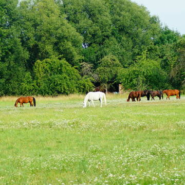
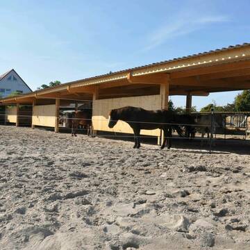
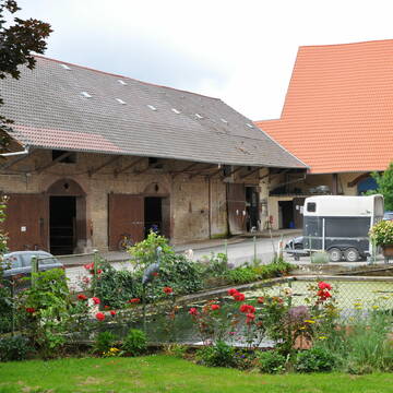
Aktivstall Heneka
Karlsdorf- Neuthard
Frau-Heneka
@Frau-Heneka
Longierzirkel/Roundpen
Parkplatz für Pferdeanhänger
Bewegungsstall
Schauer-Bewegungsstall
Vollpension
8 weitere...
P+
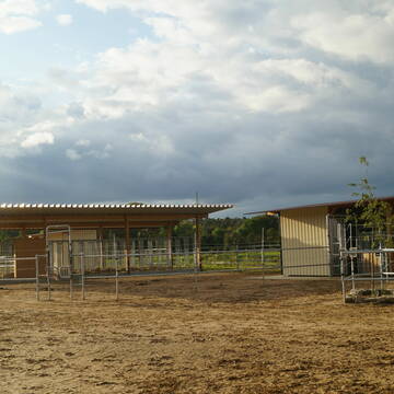
Offenstall mit Vollpension
Haßloch
Zur Sommerweide
@ZurSommerweide
Gangpferdereiten
Pferdeausbildung
Vermieten
Hunde willkommen
Krankenbox
Allergikerstall
Hufrehe geeignet
26 weitere...
P
Deprecated: Creation of dynamic property Zend_View_Helper_Ads::$adLink is deprecated in /var/www/stall-frei/htdocs/staging.stall-frei.de/library/Psf/View/Helper/Ads.php on line 108

Heu aus neuer Ernte
Mechtersen
STALL-FREIde Marketing
@STALL-FREI-Marketing
Heulage und Pferdeheu aus der neuen Ernte findest du in unserem Futtermarkt
1 Paddockbox an Selbstmister
Reilingen
Wersauer Hof
@Wersauer-Hof
FN-Mitglied
Freizeitstall
Vermieten
Führanlage
Hunde willkommen
Außenbox mit Paddock
19 weitere...
P

freie Pferdeboxen zu vermieten
Schwetzingen
Manuela-u-Bernd-Hillenbrand
@Manuela-u-Bernd-Hillenbrand
Freizeitstall
Geländestrecke
Vermieten
Longierzirkel/Roundpen
Paddock
Außenbox mit Paddock
9 weitere...
P


FREIE PADDOCKBOXEN🐴🏠
Mannheim
Reit- und Fahrverein
@RFV_Mannheim-Sandhofen_eV
FN-Mitglied
Freizeitstall
Vermieten
Hunde willkommen
Krankenbox
Hengsthaltung möglich
Hufrehe geeignet
23 weitere...
S

Boxen frei/gute Trainingsbedingungen/eig. Koppeln
Brühl
Reitverein Brühl Baden
@ReitvereinBruehlBaden
Reitlehrer und -unterricht
Vermieten
Führanlage
Hunde willkommen
Außenboxen
Innenbox
13 weitere...
P


Bonartshäuserhof, artgerechte Offenstallhaltung
Gondelsheim
Gut Bonartshäuserhof
@Bonartshaeuserhof
FN-Mitglied
Freizeitstall
Vermieten
Krankenbox
Longierzirkel/Roundpen
Gnadenbrothof
Hengsthaltung möglich
27 weitere...
S


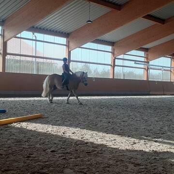
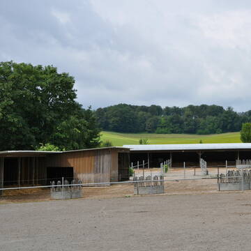
Reitanlage Moser in Sandhausen-Bruchhausen
Sandhausen
Reitanlage Moser
@Reitanlage-Moser
Fahrstall, Kutschwagen
FN-Mitglied
Vermieten
Führanlage
Paddock
Hengsthaltung möglich
Zuchtstutenhaltung möglich
21 weitere...
P+

Mitarbeiter gesucht?
Mechtersen
STALL-FREIde Marketing
@STALL-FREI-Marketing
Stellenangebote kostenlos veröffentlichen!


Pferdepension Rosenhof
Niederkirchen
Pferdepension Rosenhof
@Christine.Rau
Freizeitstall
Krankenbox
Parkplatz für Pferdeanhänger
Notfallboxen
Bewegungsstall
Laufstall
6 weitere...
P+


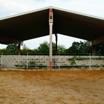
Reitanlage die keine Wünsche offen lässt
Mannheim
juergen-dehoust
@juergen-dehoust
Freizeitstall
Geländestrecke
Führanlage
Hunde willkommen
Gnadenbrothof
Hengsthaltung möglich
Außenbox mit Paddock
Außenboxen
19 weitere...
P+
Werde Teil von STALL-FREI.de
Du hast eine Pferdebox frei? Freie Plätze im Offenstall, Pferdestall oder der Reitanlage kostenlos anbieten.
Deprecated: Creation of dynamic property Zend_View::$pageCount is deprecated in /var/www/stall-frei/htdocs/staging.stall-frei.de/library/vendor/shardj/zf1-future/library/Zend/View/Abstract.php on line 308
Deprecated: Creation of dynamic property Zend_View::$itemCountPerPage is deprecated in /var/www/stall-frei/htdocs/staging.stall-frei.de/library/vendor/shardj/zf1-future/library/Zend/View/Abstract.php on line 308
Deprecated: Creation of dynamic property Zend_View::$first is deprecated in /var/www/stall-frei/htdocs/staging.stall-frei.de/library/vendor/shardj/zf1-future/library/Zend/View/Abstract.php on line 308
Deprecated: Creation of dynamic property Zend_View::$current is deprecated in /var/www/stall-frei/htdocs/staging.stall-frei.de/library/vendor/shardj/zf1-future/library/Zend/View/Abstract.php on line 308
Deprecated: Creation of dynamic property Zend_View::$last is deprecated in /var/www/stall-frei/htdocs/staging.stall-frei.de/library/vendor/shardj/zf1-future/library/Zend/View/Abstract.php on line 308
Deprecated: Creation of dynamic property Zend_View::$previous is deprecated in /var/www/stall-frei/htdocs/staging.stall-frei.de/library/vendor/shardj/zf1-future/library/Zend/View/Abstract.php on line 308
Deprecated: Creation of dynamic property Zend_View::$next is deprecated in /var/www/stall-frei/htdocs/staging.stall-frei.de/library/vendor/shardj/zf1-future/library/Zend/View/Abstract.php on line 308
Deprecated: Creation of dynamic property Zend_View::$pagesInRange is deprecated in /var/www/stall-frei/htdocs/staging.stall-frei.de/library/vendor/shardj/zf1-future/library/Zend/View/Abstract.php on line 308
Deprecated: Creation of dynamic property Zend_View::$firstPageInRange is deprecated in /var/www/stall-frei/htdocs/staging.stall-frei.de/library/vendor/shardj/zf1-future/library/Zend/View/Abstract.php on line 308
Deprecated: Creation of dynamic property Zend_View::$lastPageInRange is deprecated in /var/www/stall-frei/htdocs/staging.stall-frei.de/library/vendor/shardj/zf1-future/library/Zend/View/Abstract.php on line 308
Deprecated: Creation of dynamic property Zend_View::$currentItemCount is deprecated in /var/www/stall-frei/htdocs/staging.stall-frei.de/library/vendor/shardj/zf1-future/library/Zend/View/Abstract.php on line 308
Deprecated: Creation of dynamic property Zend_View::$totalItemCount is deprecated in /var/www/stall-frei/htdocs/staging.stall-frei.de/library/vendor/shardj/zf1-future/library/Zend/View/Abstract.php on line 308
Deprecated: Creation of dynamic property Zend_View::$firstItemNumber is deprecated in /var/www/stall-frei/htdocs/staging.stall-frei.de/library/vendor/shardj/zf1-future/library/Zend/View/Abstract.php on line 308
Deprecated: Creation of dynamic property Zend_View::$lastItemNumber is deprecated in /var/www/stall-frei/htdocs/staging.stall-frei.de/library/vendor/shardj/zf1-future/library/Zend/View/Abstract.php on line 308
Deprecated: Creation of dynamic property Zend_View::$router is deprecated in /var/www/stall-frei/htdocs/staging.stall-frei.de/library/vendor/shardj/zf1-future/library/Zend/View/Abstract.php on line 308
Deprecated: Creation of dynamic property Zend_View::$urlParams is deprecated in /var/www/stall-frei/htdocs/staging.stall-frei.de/library/vendor/shardj/zf1-future/library/Zend/View/Abstract.php on line 308
Deprecated: Creation of dynamic property Zend_View::$showAds is deprecated in /var/www/stall-frei/htdocs/staging.stall-frei.de/library/vendor/shardj/zf1-future/library/Zend/View/Abstract.php on line 308
Deprecated: Creation of dynamic property Zend_View::$objectIds is deprecated in /var/www/stall-frei/htdocs/staging.stall-frei.de/library/vendor/shardj/zf1-future/library/Zend/View/Abstract.php on line 308
Deprecated: Creation of dynamic property Zend_View::$showNavbar is deprecated in /var/www/stall-frei/htdocs/staging.stall-frei.de/library/vendor/shardj/zf1-future/library/Zend/View/Abstract.php on line 308
Deprecated: Creation of dynamic property Zend_View::$showBreadcrumb is deprecated in /var/www/stall-frei/htdocs/staging.stall-frei.de/library/vendor/shardj/zf1-future/library/Zend/View/Abstract.php on line 308
Deprecated: Creation of dynamic property Zend_View::$showFooter is deprecated in /var/www/stall-frei/htdocs/staging.stall-frei.de/library/vendor/shardj/zf1-future/library/Zend/View/Abstract.php on line 308
Deprecated: Creation of dynamic property Zend_View::$showInternalAds is deprecated in /var/www/stall-frei/htdocs/staging.stall-frei.de/library/vendor/shardj/zf1-future/library/Zend/View/Abstract.php on line 308
Deprecated: Creation of dynamic property Zend_View::$blNoContent is deprecated in /var/www/stall-frei/htdocs/staging.stall-frei.de/library/vendor/shardj/zf1-future/library/Zend/View/Abstract.php on line 308
Deprecated: Creation of dynamic property Zend_View::$sMetaDesc is deprecated in /var/www/stall-frei/htdocs/staging.stall-frei.de/library/vendor/shardj/zf1-future/library/Zend/View/Abstract.php on line 308
Deprecated: Creation of dynamic property Zend_View::$useGmaps is deprecated in /var/www/stall-frei/htdocs/staging.stall-frei.de/library/vendor/shardj/zf1-future/library/Zend/View/Abstract.php on line 308
Deprecated: Creation of dynamic property Zend_View::$touches is deprecated in /var/www/stall-frei/htdocs/staging.stall-frei.de/library/vendor/shardj/zf1-future/library/Zend/View/Abstract.php on line 308
Deprecated: Creation of dynamic property Zend_View::$oProject is deprecated in /var/www/stall-frei/htdocs/staging.stall-frei.de/library/vendor/shardj/zf1-future/library/Zend/View/Abstract.php on line 308
Deprecated: Creation of dynamic property Zend_View::$pageHeadline is deprecated in /var/www/stall-frei/htdocs/staging.stall-frei.de/library/vendor/shardj/zf1-future/library/Zend/View/Abstract.php on line 308
Deprecated: Creation of dynamic property Zend_View::$disableLocationField is deprecated in /var/www/stall-frei/htdocs/staging.stall-frei.de/library/vendor/shardj/zf1-future/library/Zend/View/Abstract.php on line 308
Deprecated: Creation of dynamic property Zend_View::$isSearch is deprecated in /var/www/stall-frei/htdocs/staging.stall-frei.de/library/vendor/shardj/zf1-future/library/Zend/View/Abstract.php on line 308
Deprecated: Creation of dynamic property Zend_View::$pageTitle is deprecated in /var/www/stall-frei/htdocs/staging.stall-frei.de/library/vendor/shardj/zf1-future/library/Zend/View/Abstract.php on line 308
Deprecated: Creation of dynamic property Psf_Form_Element_Text::$class is deprecated in /var/www/stall-frei/htdocs/staging.stall-frei.de/library/vendor/shardj/zf1-future/library/Zend/Form/Element.php on line 874
Deprecated: Creation of dynamic property Psf_Form_Element_Text::$size is deprecated in /var/www/stall-frei/htdocs/staging.stall-frei.de/library/vendor/shardj/zf1-future/library/Zend/Form/Element.php on line 874
Deprecated: Creation of dynamic property Psf_Form_Element_Text::$placeholder is deprecated in /var/www/stall-frei/htdocs/staging.stall-frei.de/library/vendor/shardj/zf1-future/library/Zend/Form/Element.php on line 874
Deprecated: Creation of dynamic property Psf_Form_Element_Hidden::$class is deprecated in /var/www/stall-frei/htdocs/staging.stall-frei.de/library/vendor/shardj/zf1-future/library/Zend/Form/Element.php on line 874
Deprecated: Creation of dynamic property Psf_Form_Element_Hidden::$class is deprecated in /var/www/stall-frei/htdocs/staging.stall-frei.de/library/vendor/shardj/zf1-future/library/Zend/Form/Element.php on line 874
Deprecated: Creation of dynamic property Psf_Form_Element_Hidden::$class is deprecated in /var/www/stall-frei/htdocs/staging.stall-frei.de/library/vendor/shardj/zf1-future/library/Zend/Form/Element.php on line 874
Deprecated: Creation of dynamic property Psf_Form_Element_Hidden::$class is deprecated in /var/www/stall-frei/htdocs/staging.stall-frei.de/library/vendor/shardj/zf1-future/library/Zend/Form/Element.php on line 874
Deprecated: Creation of dynamic property Psf_Form_Element_Select::$class is deprecated in /var/www/stall-frei/htdocs/staging.stall-frei.de/library/vendor/shardj/zf1-future/library/Zend/Form/Element.php on line 874
Deprecated: Creation of dynamic property Psf_Form_Element_Select::$class is deprecated in /var/www/stall-frei/htdocs/staging.stall-frei.de/library/vendor/shardj/zf1-future/library/Zend/Form/Element.php on line 874
Deprecated: Creation of dynamic property Psf_Form_Element_Select::$class is deprecated in /var/www/stall-frei/htdocs/staging.stall-frei.de/library/vendor/shardj/zf1-future/library/Zend/Form/Element.php on line 874
Deprecated: Creation of dynamic property Psf_Form_Element_Select::$class is deprecated in /var/www/stall-frei/htdocs/staging.stall-frei.de/library/vendor/shardj/zf1-future/library/Zend/Form/Element.php on line 874
Deprecated: Creation of dynamic property Psf_Form_Element_Text::$class is deprecated in /var/www/stall-frei/htdocs/staging.stall-frei.de/library/vendor/shardj/zf1-future/library/Zend/Form/Element.php on line 874
Deprecated: Creation of dynamic property Psf_Form_Element_Checkbox::$label is deprecated in /var/www/stall-frei/htdocs/staging.stall-frei.de/library/vendor/shardj/zf1-future/library/Zend/Form/Element.php on line 874
Deprecated: Creation of dynamic property Zend_View::$sort is deprecated in /var/www/stall-frei/htdocs/staging.stall-frei.de/library/vendor/shardj/zf1-future/library/Zend/View/Abstract.php on line 308
Deprecated: Creation of dynamic property Zend_View::$searchLocation is deprecated in /var/www/stall-frei/htdocs/staging.stall-frei.de/library/vendor/shardj/zf1-future/library/Zend/View/Abstract.php on line 308
Deprecated: Creation of dynamic property Zend_View::$locationHint is deprecated in /var/www/stall-frei/htdocs/staging.stall-frei.de/library/vendor/shardj/zf1-future/library/Zend/View/Abstract.php on line 308
Psf_GeoCoder_Abstract::getLocation: Römerberg Get Location CachedOrLive
Psf_GeoCoder_Abstract::getCachedOrLive: Römerberg
Psf_GeoCoder_Abstract::convertLocationResult
{"documentation":"https:\/\/opencagedata.com\/api","licenses":[{"name":"see attribution guide","url":"https:\/\/opencagedata.com\/credits"}],"results":[{"bounds":{"northeast":{"lat":49.3052601,"lng":8.4669735},"southwest":{"lat":49.249842,"lng":8.3643067}},"components":{"ISO_3166-1_alpha-2":"DE","ISO_3166-1_alpha-3":"DEU","ISO_3166-2":["DE-RP"],"_category":"place","_normalized_city":"R\u00f6merberg","_type":"village","continent":"Europe","country":"Deutschland","country_code":"de","county":"Rhein-Pfalz-Kreis","municipality":"R\u00f6merberg-Dudenhofen","political_union":"European Union","postcode":"67354","state":"Rheinland-Pfalz","state_code":"RP","village":"R\u00f6merberg"},"confidence":7,"formatted":"67354 R\u00f6merberg, Deutschland","geometry":{"lat":49.2803387,"lng":8.4007852}},{"bounds":{"northeast":{"lat":50.1108688,"lng":8.6827372},"southwest":{"lat":50.1095495,"lng":8.6816127}},"components":{"ISO_3166-1_alpha-2":"DE","ISO_3166-1_alpha-3":"DEU","ISO_3166-2":["DE-HE"],"_category":"road","_normalized_city":"Frankfurt am Main","_type":"road","city":"Frankfurt am Main","city_district":"Innenstadt 1","continent":"Europe","country":"Deutschland","country_code":"de","political_union":"European Union","postcode":"60311","road":"R\u00f6merberg","road_type":"pedestrian","state":"Hessen","state_code":"HE","suburb":"Altstadt"},"confidence":9,"formatted":"R\u00f6merberg, 60311 Frankfurt am Main, Deutschland","geometry":{"lat":50.1102096,"lng":8.6821665}},{"bounds":{"northeast":{"lat":50.1242597,"lng":6.9269332},"southwest":{"lat":50.1241597,"lng":6.9268332}},"components":{"ISO_3166-1_alpha-2":"DE","ISO_3166-1_alpha-3":"DEU","ISO_3166-2":["DE-RP"],"_category":"natural\/water","_normalized_city":"Strohn","_type":"peak","continent":"Europe","country":"Deutschland","country_code":"de","county":"Landkreis Vulkaneifel","municipality":"Daun","peak":"R\u00f6merberg","political_union":"European Union","postcode":"54558","state":"Rheinland-Pfalz","state_code":"RP","village":"Strohn"},"confidence":9,"formatted":"R\u00f6merberg, 54558 Strohn, Deutschland","geometry":{"lat":50.1242097,"lng":6.9268832}},{"bounds":{"northeast":{"lat":51.3918937,"lng":7.9356264},"southwest":{"lat":51.3917937,"lng":7.9355264}},"components":{"ISO_3166-1_alpha-2":"DE","ISO_3166-1_alpha-3":"DEU","ISO_3166-2":["DE-NW"],"_category":"natural\/water","_normalized_city":"Arnsberg","_type":"peak","continent":"Europe","country":"Deutschland","country_code":"de","county":"Hochsauerlandkreis","peak":"R\u00f6merberg","political_union":"European Union","postcode":"59757","state":"Nordrhein-Westfalen","state_code":"NW","town":"Arnsberg"},"confidence":9,"formatted":"R\u00f6merberg, 59757 Arnsberg, Deutschland","geometry":{"lat":51.3918437,"lng":7.9355764}},{"bounds":{"northeast":{"lat":53.5764644,"lng":13.8814845},"southwest":{"lat":53.5763644,"lng":13.8813845}},"components":{"ISO_3166-1_alpha-2":"DE","ISO_3166-1_alpha-3":"DEU","ISO_3166-2":["DE-MV"],"_category":"natural\/water","_normalized_city":"Rothem\u00fchl","_type":"peak","continent":"Europe","country":"Deutschland","country_code":"de","county":"Vorpommern-Greifswald","municipality":"Torgelow-Ferdinandshof","peak":"R\u00f6merberg","political_union":"European Union","state":"Mecklenburg-Vorpommern","state_code":"MV","village":"Rothem\u00fchl"},"confidence":9,"formatted":"R\u00f6merberg, Rothem\u00fchl, Mecklenburg-Vorpommern, Deutschland","geometry":{"lat":53.5764144,"lng":13.8814345}},{"bounds":{"northeast":{"lat":49.9003083,"lng":6.2678575},"southwest":{"lat":49.9002083,"lng":6.2677575}},"components":{"ISO_3166-1_alpha-2":"DE","ISO_3166-1_alpha-3":"DEU","ISO_3166-2":["DE-RP"],"_category":"natural\/water","_normalized_city":"K\u00f6rperich","_type":"peak","continent":"Europe","country":"Deutschland","country_code":"de","county":"Eifelkreis Bitburg-Pr\u00fcm","municipality":"S\u00fcdeifel","peak":"R\u00f6merberg","political_union":"European Union","state":"Rheinland-Pfalz","state_code":"RP","village":"K\u00f6rperich"},"confidence":9,"formatted":"R\u00f6merberg, K\u00f6rperich, Rheinland-Pfalz, Deutschland","geometry":{"lat":49.9002583,"lng":6.2678075}},{"bounds":{"northeast":{"lat":51.7928447,"lng":8.9078453},"southwest":{"lat":51.7927447,"lng":8.9077453}},"components":{"ISO_3166-1_alpha-2":"DE","ISO_3166-1_alpha-3":"DEU","ISO_3166-2":["DE-NW"],"_category":"natural\/water","_normalized_city":"Altenbeken","_type":"peak","continent":"Europe","country":"Deutschland","country_code":"de","county":"Kreis Paderborn","peak":"R\u00f6merberg","political_union":"European Union","state":"Nordrhein-Westfalen","state_code":"NW","village":"Altenbeken"},"confidence":9,"formatted":"R\u00f6merberg, Altenbeken, Nordrhein-Westfalen, Deutschland","geometry":{"lat":51.7927947,"lng":8.9077953}},{"bounds":{"northeast":{"lat":48.8949277,"lng":8.6119785},"southwest":{"lat":48.8948277,"lng":8.6118785}},"components":{"ISO_3166-1_alpha-2":"DE","ISO_3166-1_alpha-3":"DEU","ISO_3166-2":["DE-BW"],"_category":"natural\/water","_normalized_city":"Keltern","_type":"peak","continent":"Europe","country":"Deutschland","country_code":"de","county":"Enzkreis","municipality":"Keltern","peak":"R\u00f6merberg","political_union":"European Union","postcode":"75217","state":"Baden-W\u00fcrttemberg","state_code":"BW"},"confidence":9,"formatted":"R\u00f6merberg, 75217 Keltern, Deutschland","geometry":{"lat":48.8948777,"lng":8.6119285}},{"bounds":{"northeast":{"lat":51.5038673,"lng":11.9562397},"southwest":{"lat":51.5037673,"lng":11.9561397}},"components":{"ISO_3166-1_alpha-2":"DE","ISO_3166-1_alpha-3":"DEU","ISO_3166-2":["DE-ST"],"_category":"natural\/water","_normalized_city":"Halle (Saale)","_type":"peak","city":"Halle (Saale)","continent":"Europe","country":"Deutschland","country_code":"de","peak":"R\u00f6merberg","political_union":"European Union","postcode":"06114","state":"Sachsen-Anhalt","state_code":"ST"},"confidence":9,"formatted":"R\u00f6merberg, 06114 Halle (Saale), Deutschland","geometry":{"lat":51.5038173,"lng":11.9561897}},{"components":{"ISO_3166-1_alpha-2":"FR","ISO_3166-1_alpha-3":"FRA","ISO_3166-2":["FR-CVL","FR-28"],"_category":"road","_normalized_city":"Mainvilliers","_type":"road","city":"Mainvilliers","continent":"Europe","country":"France","country_code":"fr","county":"Eure-et-Loir","local_authority":"Communaut\u00e9 d'agglom\u00e9ration Chartres M\u00e9tropole","political_union":"European Union","postcode":"28300","road":"Rue de R\u00f6merberg","state":"Centre-Val de Loire","state_code":"CVL"},"confidence":4,"formatted":"Rue de R\u00f6merberg, 28300 Mainvilliers, France","geometry":{"lat":48.454134,"lng":1.457413}}],"status":{"code":200,"message":"OK"},"stay_informed":{"blog":"https:\/\/blog.opencagedata.com","mastodon":"https:\/\/en.osm.town\/@opencage"},"thanks":"For using an OpenCage API","timestamp":{"created_http":"Sat, 07 Feb 2026 23:12:32 GMT","created_unix":1770505952},"total_results":10}Array
(
[0] => stdClass Object
(
[bounds] => stdClass Object
(
[northeast] => stdClass Object
(
[lat] => 49.3052601
[lng] => 8.4669735
)
[southwest] => stdClass Object
(
[lat] => 49.249842
[lng] => 8.3643067
)
)
[components] => stdClass Object
(
[ISO_3166-1_alpha-2] => DE
[ISO_3166-1_alpha-3] => DEU
[ISO_3166-2] => Array
(
[0] => DE-RP
)
[_category] => place
[_normalized_city] => Römerberg
[_type] => village
[continent] => Europe
[country] => Deutschland
[country_code] => de
[county] => Rhein-Pfalz-Kreis
[municipality] => Römerberg-Dudenhofen
[political_union] => European Union
[postcode] => 67354
[state] => Rheinland-Pfalz
[state_code] => RP
[village] => Römerberg
)
[confidence] => 7
[formatted] => 67354 Römerberg, Deutschland
[geometry] => stdClass Object
(
[lat] => 49.2803387
[lng] => 8.4007852
)
)
[1] => stdClass Object
(
[bounds] => stdClass Object
(
[northeast] => stdClass Object
(
[lat] => 50.1108688
[lng] => 8.6827372
)
[southwest] => stdClass Object
(
[lat] => 50.1095495
[lng] => 8.6816127
)
)
[components] => stdClass Object
(
[ISO_3166-1_alpha-2] => DE
[ISO_3166-1_alpha-3] => DEU
[ISO_3166-2] => Array
(
[0] => DE-HE
)
[_category] => road
[_normalized_city] => Frankfurt am Main
[_type] => road
[city] => Frankfurt am Main
[city_district] => Innenstadt 1
[continent] => Europe
[country] => Deutschland
[country_code] => de
[political_union] => European Union
[postcode] => 60311
[road] => Römerberg
[road_type] => pedestrian
[state] => Hessen
[state_code] => HE
[suburb] => Altstadt
)
[confidence] => 9
[formatted] => Römerberg, 60311 Frankfurt am Main, Deutschland
[geometry] => stdClass Object
(
[lat] => 50.1102096
[lng] => 8.6821665
)
)
[2] => stdClass Object
(
[bounds] => stdClass Object
(
[northeast] => stdClass Object
(
[lat] => 50.1242597
[lng] => 6.9269332
)
[southwest] => stdClass Object
(
[lat] => 50.1241597
[lng] => 6.9268332
)
)
[components] => stdClass Object
(
[ISO_3166-1_alpha-2] => DE
[ISO_3166-1_alpha-3] => DEU
[ISO_3166-2] => Array
(
[0] => DE-RP
)
[_category] => natural/water
[_normalized_city] => Strohn
[_type] => peak
[continent] => Europe
[country] => Deutschland
[country_code] => de
[county] => Landkreis Vulkaneifel
[municipality] => Daun
[peak] => Römerberg
[political_union] => European Union
[postcode] => 54558
[state] => Rheinland-Pfalz
[state_code] => RP
[village] => Strohn
)
[confidence] => 9
[formatted] => Römerberg, 54558 Strohn, Deutschland
[geometry] => stdClass Object
(
[lat] => 50.1242097
[lng] => 6.9268832
)
)
[3] => stdClass Object
(
[bounds] => stdClass Object
(
[northeast] => stdClass Object
(
[lat] => 51.3918937
[lng] => 7.9356264
)
[southwest] => stdClass Object
(
[lat] => 51.3917937
[lng] => 7.9355264
)
)
[components] => stdClass Object
(
[ISO_3166-1_alpha-2] => DE
[ISO_3166-1_alpha-3] => DEU
[ISO_3166-2] => Array
(
[0] => DE-NW
)
[_category] => natural/water
[_normalized_city] => Arnsberg
[_type] => peak
[continent] => Europe
[country] => Deutschland
[country_code] => de
[county] => Hochsauerlandkreis
[peak] => Römerberg
[political_union] => European Union
[postcode] => 59757
[state] => Nordrhein-Westfalen
[state_code] => NW
[town] => Arnsberg
)
[confidence] => 9
[formatted] => Römerberg, 59757 Arnsberg, Deutschland
[geometry] => stdClass Object
(
[lat] => 51.3918437
[lng] => 7.9355764
)
)
[4] => stdClass Object
(
[bounds] => stdClass Object
(
[northeast] => stdClass Object
(
[lat] => 53.5764644
[lng] => 13.8814845
)
[southwest] => stdClass Object
(
[lat] => 53.5763644
[lng] => 13.8813845
)
)
[components] => stdClass Object
(
[ISO_3166-1_alpha-2] => DE
[ISO_3166-1_alpha-3] => DEU
[ISO_3166-2] => Array
(
[0] => DE-MV
)
[_category] => natural/water
[_normalized_city] => Rothemühl
[_type] => peak
[continent] => Europe
[country] => Deutschland
[country_code] => de
[county] => Vorpommern-Greifswald
[municipality] => Torgelow-Ferdinandshof
[peak] => Römerberg
[political_union] => European Union
[state] => Mecklenburg-Vorpommern
[state_code] => MV
[village] => Rothemühl
)
[confidence] => 9
[formatted] => Römerberg, Rothemühl, Mecklenburg-Vorpommern, Deutschland
[geometry] => stdClass Object
(
[lat] => 53.5764144
[lng] => 13.8814345
)
)
[5] => stdClass Object
(
[bounds] => stdClass Object
(
[northeast] => stdClass Object
(
[lat] => 49.9003083
[lng] => 6.2678575
)
[southwest] => stdClass Object
(
[lat] => 49.9002083
[lng] => 6.2677575
)
)
[components] => stdClass Object
(
[ISO_3166-1_alpha-2] => DE
[ISO_3166-1_alpha-3] => DEU
[ISO_3166-2] => Array
(
[0] => DE-RP
)
[_category] => natural/water
[_normalized_city] => Körperich
[_type] => peak
[continent] => Europe
[country] => Deutschland
[country_code] => de
[county] => Eifelkreis Bitburg-Prüm
[municipality] => Südeifel
[peak] => Römerberg
[political_union] => European Union
[state] => Rheinland-Pfalz
[state_code] => RP
[village] => Körperich
)
[confidence] => 9
[formatted] => Römerberg, Körperich, Rheinland-Pfalz, Deutschland
[geometry] => stdClass Object
(
[lat] => 49.9002583
[lng] => 6.2678075
)
)
[6] => stdClass Object
(
[bounds] => stdClass Object
(
[northeast] => stdClass Object
(
[lat] => 51.7928447
[lng] => 8.9078453
)
[southwest] => stdClass Object
(
[lat] => 51.7927447
[lng] => 8.9077453
)
)
[components] => stdClass Object
(
[ISO_3166-1_alpha-2] => DE
[ISO_3166-1_alpha-3] => DEU
[ISO_3166-2] => Array
(
[0] => DE-NW
)
[_category] => natural/water
[_normalized_city] => Altenbeken
[_type] => peak
[continent] => Europe
[country] => Deutschland
[country_code] => de
[county] => Kreis Paderborn
[peak] => Römerberg
[political_union] => European Union
[state] => Nordrhein-Westfalen
[state_code] => NW
[village] => Altenbeken
)
[confidence] => 9
[formatted] => Römerberg, Altenbeken, Nordrhein-Westfalen, Deutschland
[geometry] => stdClass Object
(
[lat] => 51.7927947
[lng] => 8.9077953
)
)
[7] => stdClass Object
(
[bounds] => stdClass Object
(
[northeast] => stdClass Object
(
[lat] => 48.8949277
[lng] => 8.6119785
)
[southwest] => stdClass Object
(
[lat] => 48.8948277
[lng] => 8.6118785
)
)
[components] => stdClass Object
(
[ISO_3166-1_alpha-2] => DE
[ISO_3166-1_alpha-3] => DEU
[ISO_3166-2] => Array
(
[0] => DE-BW
)
[_category] => natural/water
[_normalized_city] => Keltern
[_type] => peak
[continent] => Europe
[country] => Deutschland
[country_code] => de
[county] => Enzkreis
[municipality] => Keltern
[peak] => Römerberg
[political_union] => European Union
[postcode] => 75217
[state] => Baden-Württemberg
[state_code] => BW
)
[confidence] => 9
[formatted] => Römerberg, 75217 Keltern, Deutschland
[geometry] => stdClass Object
(
[lat] => 48.8948777
[lng] => 8.6119285
)
)
[8] => stdClass Object
(
[bounds] => stdClass Object
(
[northeast] => stdClass Object
(
[lat] => 51.5038673
[lng] => 11.9562397
)
[southwest] => stdClass Object
(
[lat] => 51.5037673
[lng] => 11.9561397
)
)
[components] => stdClass Object
(
[ISO_3166-1_alpha-2] => DE
[ISO_3166-1_alpha-3] => DEU
[ISO_3166-2] => Array
(
[0] => DE-ST
)
[_category] => natural/water
[_normalized_city] => Halle (Saale)
[_type] => peak
[city] => Halle (Saale)
[continent] => Europe
[country] => Deutschland
[country_code] => de
[peak] => Römerberg
[political_union] => European Union
[postcode] => 06114
[state] => Sachsen-Anhalt
[state_code] => ST
)
[confidence] => 9
[formatted] => Römerberg, 06114 Halle (Saale), Deutschland
[geometry] => stdClass Object
(
[lat] => 51.5038173
[lng] => 11.9561897
)
)
[9] => stdClass Object
(
[components] => stdClass Object
(
[ISO_3166-1_alpha-2] => FR
[ISO_3166-1_alpha-3] => FRA
[ISO_3166-2] => Array
(
[0] => FR-CVL
[1] => FR-28
)
[_category] => road
[_normalized_city] => Mainvilliers
[_type] => road
[city] => Mainvilliers
[continent] => Europe
[country] => France
[country_code] => fr
[county] => Eure-et-Loir
[local_authority] => Communauté d'agglomération Chartres Métropole
[political_union] => European Union
[postcode] => 28300
[road] => Rue de Römerberg
[state] => Centre-Val de Loire
[state_code] => CVL
)
[confidence] => 4
[formatted] => Rue de Römerberg, 28300 Mainvilliers, France
[geometry] => stdClass Object
(
[lat] => 48.454134
[lng] => 1.457413
)
)
)
Psf_GeoCoder_OpenCageData::getKeyMap: 0
stdClass Object
(
    [bounds] => stdClass Object
        (
            [northeast] => stdClass Object
                (
                    [lat] => 49.3052601
                    [lng] => 8.4669735
                )

            [southwest] => stdClass Object
                (
                    [lat] => 49.249842
                    [lng] => 8.3643067
                )

        )

    [components] => stdClass Object
        (
            [ISO_3166-1_alpha-2] => DE
            [ISO_3166-1_alpha-3] => DEU
            [ISO_3166-2] => Array
                (
                    [0] => DE-RP
                )

            [_category] => place
            [_normalized_city] => Römerberg
            [_type] => village
            [continent] => Europe
            [country] => Deutschland
            [country_code] => de
            [county] => Rhein-Pfalz-Kreis
            [municipality] => Römerberg-Dudenhofen
            [political_union] => European Union
            [postcode] => 67354
            [state] => Rheinland-Pfalz
            [state_code] => RP
            [village] => Römerberg
        )

    [confidence] => 7
    [formatted] => 67354 Römerberg, Deutschland
    [geometry] => stdClass Object
        (
            [lat] => 49.2803387
            [lng] => 8.4007852
        )

)
Psf_GeoCoder_OpenCageData::getCounty: Rhein-Pfalz-Kreis
Psf_GeoCoder_OpenCageData::addMissingData REFETCH!
Array
(
    [address] => 67354 Römerberg, Deutschland
    [type] => village
    [street] =>
    [city] => Römerberg
    [county] => Rhein-Pfalz-Kreis
    [state] => Rheinland-Pfalz
    [zip] => 67354
    [country] => Deutschland
    [suburb] =>
    [countrycode] => de
    [latitude] => 49.2803387
    [longitude] => 8.4007852
    [accuracy] => 1
    [confidence] => 7
    [bounds] => stdClass Object
        (
            [northeast] => stdClass Object
                (
                    [lat] => 49.3052601
                    [lng] => 8.4669735
                )

            [southwest] => stdClass Object
                (
                    [lat] => 49.249842
                    [lng] => 8.3643067
                )

        )

)
reformat!
Array
(
    [address] => 67354 Römerberg, Deutschland
    [type] => village
    [street] =>
    [city] => Römerberg
    [county] => Rhein-Pfalz-Kreis
    [state] => Rheinland-Pfalz
    [zip] => 67354
    [country] => Deutschland
    [suburb] =>
    [countrycode] => de
    [latitude] => 49.2803387
    [longitude] => 8.4007852
    [accuracy] => 1
    [confidence] => 7
    [bounds] => stdClass Object
        (
            [northeast] => stdClass Object
                (
                    [lat] => 49.3052601
                    [lng] => 8.4669735
                )

            [southwest] => stdClass Object
                (
                    [lat] => 49.249842
                    [lng] => 8.3643067
                )

        )

    [place] => 67354 Römerberg, Rheinland-Pfalz
    [hash] => 709f383c409acfa663b358b405eafbd7
)
Psf_GeoCoder_OpenCageData::getKeyMap: 1
stdClass Object
(
    [bounds] => stdClass Object
        (
            [northeast] => stdClass Object
                (
                    [lat] => 50.1108688
                    [lng] => 8.6827372
                )

            [southwest] => stdClass Object
                (
                    [lat] => 50.1095495
                    [lng] => 8.6816127
                )

        )

    [components] => stdClass Object
        (
            [ISO_3166-1_alpha-2] => DE
            [ISO_3166-1_alpha-3] => DEU
            [ISO_3166-2] => Array
                (
                    [0] => DE-HE
                )

            [_category] => road
            [_normalized_city] => Frankfurt am Main
            [_type] => road
            [city] => Frankfurt am Main
            [city_district] => Innenstadt 1
            [continent] => Europe
            [country] => Deutschland
            [country_code] => de
            [political_union] => European Union
            [postcode] => 60311
            [road] => Römerberg
            [road_type] => pedestrian
            [state] => Hessen
            [state_code] => HE
            [suburb] => Altstadt
        )

    [confidence] => 9
    [formatted] => Römerberg, 60311 Frankfurt am Main, Deutschland
    [geometry] => stdClass Object
        (
            [lat] => 50.1102096
            [lng] => 8.6821665
        )

)
Psf_GeoCoder_OpenCageData::getCounty: Frankfurt am Main
Psf_GeoCoder_OpenCageData::addMissingData REFETCH!
Array
(
    [address] => Römerberg, 60311 Frankfurt am Main, Deutschland
    [type] => road
    [street] => Römerberg
    [city] => Altstadt
    [county] => Frankfurt am Main
    [state] => Hessen
    [zip] => 60311
    [country] => Deutschland
    [suburb] => Altstadt
    [countrycode] => de
    [latitude] => 50.1102096
    [longitude] => 8.6821665
    [accuracy] => 1
    [confidence] => 9
    [bounds] => stdClass Object
        (
            [northeast] => stdClass Object
                (
                    [lat] => 50.1108688
                    [lng] => 8.6827372
                )

            [southwest] => stdClass Object
                (
                    [lat] => 50.1095495
                    [lng] => 8.6816127
                )

        )

)
reformat!
Array
(
    [address] => Römerberg, 60311 Altstadt
    [type] => road
    [street] => Römerberg
    [city] => Altstadt
    [county] => Frankfurt am Main
    [state] => Hessen
    [zip] => 60311
    [country] => Deutschland
    [suburb] => Altstadt
    [countrycode] => de
    [latitude] => 50.1102096
    [longitude] => 8.6821665
    [accuracy] => 1
    [confidence] => 9
    [bounds] => stdClass Object
        (
            [northeast] => stdClass Object
                (
                    [lat] => 50.1108688
                    [lng] => 8.6827372
                )

            [southwest] => stdClass Object
                (
                    [lat] => 50.1095495
                    [lng] => 8.6816127
                )

        )

    [place] => Römerberg, 60311 Altstadt, Hessen
    [hash] => 329f6dfd937f07d3c05b95fcf43c916c
)
Psf_GeoCoder_OpenCageData::getKeyMap: 2
stdClass Object
(
    [bounds] => stdClass Object
        (
            [northeast] => stdClass Object
                (
                    [lat] => 50.1242597
                    [lng] => 6.9269332
                )

            [southwest] => stdClass Object
                (
                    [lat] => 50.1241597
                    [lng] => 6.9268332
                )

        )

    [components] => stdClass Object
        (
            [ISO_3166-1_alpha-2] => DE
            [ISO_3166-1_alpha-3] => DEU
            [ISO_3166-2] => Array
                (
                    [0] => DE-RP
                )

            [_category] => natural/water
            [_normalized_city] => Strohn
            [_type] => peak
            [continent] => Europe
            [country] => Deutschland
            [country_code] => de
            [county] => Landkreis Vulkaneifel
            [municipality] => Daun
            [peak] => Römerberg
            [political_union] => European Union
            [postcode] => 54558
            [state] => Rheinland-Pfalz
            [state_code] => RP
            [village] => Strohn
        )

    [confidence] => 9
    [formatted] => Römerberg, 54558 Strohn, Deutschland
    [geometry] => stdClass Object
        (
            [lat] => 50.1242097
            [lng] => 6.9268832
        )

)
Psf_GeoCoder_OpenCageData::getCounty: Vulkaneifel
Psf_GeoCoder_OpenCageData::addMissingData REFETCH!
Array
(
    [address] => Römerberg, 54558 Strohn, Deutschland
    [type] => peak
    [street] =>
    [city] => Strohn
    [county] => Vulkaneifel
    [state] => Rheinland-Pfalz
    [zip] => 54558
    [country] => Deutschland
    [suburb] =>
    [countrycode] => de
    [latitude] => 50.1242097
    [longitude] => 6.9268832
    [accuracy] => 1
    [confidence] => 9
    [bounds] => stdClass Object
        (
            [northeast] => stdClass Object
                (
                    [lat] => 50.1242597
                    [lng] => 6.9269332
                )

            [southwest] => stdClass Object
                (
                    [lat] => 50.1241597
                    [lng] => 6.9268332
                )

        )

)
reformat!
Array
(
    [address] => Römerberg, 54558 Strohn, Deutschland
    [type] => peak
    [street] =>
    [city] => Strohn
    [county] => Vulkaneifel
    [state] => Rheinland-Pfalz
    [zip] => 54558
    [country] => Deutschland
    [suburb] =>
    [countrycode] => de
    [latitude] => 50.1242097
    [longitude] => 6.9268832
    [accuracy] => 1
    [confidence] => 9
    [bounds] => stdClass Object
        (
            [northeast] => stdClass Object
                (
                    [lat] => 50.1242597
                    [lng] => 6.9269332
                )

            [southwest] => stdClass Object
                (
                    [lat] => 50.1241597
                    [lng] => 6.9268332
                )

        )

    [place] => 54558 Strohn, Rheinland-Pfalz
    [hash] => 5a16f431be680867b07077ec92a1c975
)
Psf_GeoCoder_OpenCageData::getKeyMap: 3
stdClass Object
(
    [bounds] => stdClass Object
        (
            [northeast] => stdClass Object
                (
                    [lat] => 51.3918937
                    [lng] => 7.9356264
                )

            [southwest] => stdClass Object
                (
                    [lat] => 51.3917937
                    [lng] => 7.9355264
                )

        )

    [components] => stdClass Object
        (
            [ISO_3166-1_alpha-2] => DE
            [ISO_3166-1_alpha-3] => DEU
            [ISO_3166-2] => Array
                (
                    [0] => DE-NW
                )

            [_category] => natural/water
            [_normalized_city] => Arnsberg
            [_type] => peak
            [continent] => Europe
            [country] => Deutschland
            [country_code] => de
            [county] => Hochsauerlandkreis
            [peak] => Römerberg
            [political_union] => European Union
            [postcode] => 59757
            [state] => Nordrhein-Westfalen
            [state_code] => NW
            [town] => Arnsberg
        )

    [confidence] => 9
    [formatted] => Römerberg, 59757 Arnsberg, Deutschland
    [geometry] => stdClass Object
        (
            [lat] => 51.3918437
            [lng] => 7.9355764
        )

)
Psf_GeoCoder_OpenCageData::getCounty: Hochsauerlandkreis
Psf_GeoCoder_OpenCageData::addMissingData REFETCH!
Array
(
    [address] => Römerberg, 59757 Arnsberg, Deutschland
    [type] => peak
    [street] =>
    [city] => Arnsberg
    [county] => Hochsauerlandkreis
    [state] => Nordrhein-Westfalen
    [zip] => 59757
    [country] => Deutschland
    [suburb] =>
    [countrycode] => de
    [latitude] => 51.3918437
    [longitude] => 7.9355764
    [accuracy] => 1
    [confidence] => 9
    [bounds] => stdClass Object
        (
            [northeast] => stdClass Object
                (
                    [lat] => 51.3918937
                    [lng] => 7.9356264
                )

            [southwest] => stdClass Object
                (
                    [lat] => 51.3917937
                    [lng] => 7.9355264
                )

        )

)
reformat!
Array
(
    [address] => Römerberg, 59757 Arnsberg, Deutschland
    [type] => peak
    [street] =>
    [city] => Arnsberg
    [county] => Hochsauerlandkreis
    [state] => Nordrhein-Westfalen
    [zip] => 59757
    [country] => Deutschland
    [suburb] =>
    [countrycode] => de
    [latitude] => 51.3918437
    [longitude] => 7.9355764
    [accuracy] => 1
    [confidence] => 9
    [bounds] => stdClass Object
        (
            [northeast] => stdClass Object
                (
                    [lat] => 51.3918937
                    [lng] => 7.9356264
                )

            [southwest] => stdClass Object
                (
                    [lat] => 51.3917937
                    [lng] => 7.9355264
                )

        )

    [place] => 59757 Arnsberg, Nordrhein-Westfalen
    [hash] => 9711bc133e0e7cd8670c9f3a98b09968
)
Psf_GeoCoder_OpenCageData::getKeyMap: 4
stdClass Object
(
    [bounds] => stdClass Object
        (
            [northeast] => stdClass Object
                (
                    [lat] => 53.5764644
                    [lng] => 13.8814845
                )

            [southwest] => stdClass Object
                (
                    [lat] => 53.5763644
                    [lng] => 13.8813845
                )

        )

    [components] => stdClass Object
        (
            [ISO_3166-1_alpha-2] => DE
            [ISO_3166-1_alpha-3] => DEU
            [ISO_3166-2] => Array
                (
                    [0] => DE-MV
                )

            [_category] => natural/water
            [_normalized_city] => Rothemühl
            [_type] => peak
            [continent] => Europe
            [country] => Deutschland
            [country_code] => de
            [county] => Vorpommern-Greifswald
            [municipality] => Torgelow-Ferdinandshof
            [peak] => Römerberg
            [political_union] => European Union
            [state] => Mecklenburg-Vorpommern
            [state_code] => MV
            [village] => Rothemühl
        )

    [confidence] => 9
    [formatted] => Römerberg, Rothemühl, Mecklenburg-Vorpommern, Deutschland
    [geometry] => stdClass Object
        (
            [lat] => 53.5764144
            [lng] => 13.8814345
        )

)
Psf_GeoCoder_OpenCageData::getCounty: Vorpommern-Greifswald
Psf_GeoCoder_OpenCageData::addMissingData REFETCH!
Array
(
    [address] => Römerberg, Rothemühl, Mecklenburg-Vorpommern, Deutschland
    [type] => peak
    [street] =>
    [city] => Rothemühl
    [county] => Vorpommern-Greifswald
    [state] => Mecklenburg-Vorpommern
    [zip] =>
    [country] => Deutschland
    [suburb] =>
    [countrycode] => de
    [latitude] => 53.5764144
    [longitude] => 13.8814345
    [accuracy] => 1
    [confidence] => 9
    [bounds] => stdClass Object
        (
            [northeast] => stdClass Object
                (
                    [lat] => 53.5764644
                    [lng] => 13.8814845
                )

            [southwest] => stdClass Object
                (
                    [lat] => 53.5763644
                    [lng] => 13.8813845
                )

        )

)
reformat!
Array
(
    [address] => Römerberg, Rothemühl, Mecklenburg-Vorpommern, Deutschland
    [type] => peak
    [street] =>
    [city] => Rothemühl
    [county] => Vorpommern-Greifswald
    [state] => Mecklenburg-Vorpommern
    [zip] =>
    [country] => Deutschland
    [suburb] =>
    [countrycode] => de
    [latitude] => 53.5764144
    [longitude] => 13.8814345
    [accuracy] => 1
    [confidence] => 9
    [bounds] => stdClass Object
        (
            [northeast] => stdClass Object
                (
                    [lat] => 53.5764644
                    [lng] => 13.8814845
                )

            [southwest] => stdClass Object
                (
                    [lat] => 53.5763644
                    [lng] => 13.8813845
                )

        )

    [place] => Rothemühl, Mecklenburg-Vorpommern
    [hash] => 877902f7870312ebb4c21270c932fb4a
)
Psf_GeoCoder_OpenCageData::getKeyMap: 5
stdClass Object
(
    [bounds] => stdClass Object
        (
            [northeast] => stdClass Object
                (
                    [lat] => 49.9003083
                    [lng] => 6.2678575
                )

            [southwest] => stdClass Object
                (
                    [lat] => 49.9002083
                    [lng] => 6.2677575
                )

        )

    [components] => stdClass Object
        (
            [ISO_3166-1_alpha-2] => DE
            [ISO_3166-1_alpha-3] => DEU
            [ISO_3166-2] => Array
                (
                    [0] => DE-RP
                )

            [_category] => natural/water
            [_normalized_city] => Körperich
            [_type] => peak
            [continent] => Europe
            [country] => Deutschland
            [country_code] => de
            [county] => Eifelkreis Bitburg-Prüm
            [municipality] => Südeifel
            [peak] => Römerberg
            [political_union] => European Union
            [state] => Rheinland-Pfalz
            [state_code] => RP
            [village] => Körperich
        )

    [confidence] => 9
    [formatted] => Römerberg, Körperich, Rheinland-Pfalz, Deutschland
    [geometry] => stdClass Object
        (
            [lat] => 49.9002583
            [lng] => 6.2678075
        )

)
Psf_GeoCoder_OpenCageData::getCounty: Eifelkreis Bitburg-Prüm
Psf_GeoCoder_OpenCageData::addMissingData REFETCH!
Array
(
    [address] => Römerberg, Körperich, Rheinland-Pfalz, Deutschland
    [type] => peak
    [street] =>
    [city] => Körperich
    [county] => Eifelkreis Bitburg-Prüm
    [state] => Rheinland-Pfalz
    [zip] =>
    [country] => Deutschland
    [suburb] =>
    [countrycode] => de
    [latitude] => 49.9002583
    [longitude] => 6.2678075
    [accuracy] => 1
    [confidence] => 9
    [bounds] => stdClass Object
        (
            [northeast] => stdClass Object
                (
                    [lat] => 49.9003083
                    [lng] => 6.2678575
                )

            [southwest] => stdClass Object
                (
                    [lat] => 49.9002083
                    [lng] => 6.2677575
                )

        )

)
reformat!
Array
(
    [address] => Römerberg, Körperich, Rheinland-Pfalz, Deutschland
    [type] => peak
    [street] =>
    [city] => Körperich
    [county] => Eifelkreis Bitburg-Prüm
    [state] => Rheinland-Pfalz
    [zip] =>
    [country] => Deutschland
    [suburb] =>
    [countrycode] => de
    [latitude] => 49.9002583
    [longitude] => 6.2678075
    [accuracy] => 1
    [confidence] => 9
    [bounds] => stdClass Object
        (
            [northeast] => stdClass Object
                (
                    [lat] => 49.9003083
                    [lng] => 6.2678575
                )

            [southwest] => stdClass Object
                (
                    [lat] => 49.9002083
                    [lng] => 6.2677575
                )

        )

    [place] => Körperich, Rheinland-Pfalz
    [hash] => 3243da85328414b28b07f118416e8443
)
Psf_GeoCoder_OpenCageData::getKeyMap: 6
stdClass Object
(
    [bounds] => stdClass Object
        (
            [northeast] => stdClass Object
                (
                    [lat] => 51.7928447
                    [lng] => 8.9078453
                )

            [southwest] => stdClass Object
                (
                    [lat] => 51.7927447
                    [lng] => 8.9077453
                )

        )

    [components] => stdClass Object
        (
            [ISO_3166-1_alpha-2] => DE
            [ISO_3166-1_alpha-3] => DEU
            [ISO_3166-2] => Array
                (
                    [0] => DE-NW
                )

            [_category] => natural/water
            [_normalized_city] => Altenbeken
            [_type] => peak
            [continent] => Europe
            [country] => Deutschland
            [country_code] => de
            [county] => Kreis Paderborn
            [peak] => Römerberg
            [political_union] => European Union
            [state] => Nordrhein-Westfalen
            [state_code] => NW
            [village] => Altenbeken
        )

    [confidence] => 9
    [formatted] => Römerberg, Altenbeken, Nordrhein-Westfalen, Deutschland
    [geometry] => stdClass Object
        (
            [lat] => 51.7927947
            [lng] => 8.9077953
        )

)
Psf_GeoCoder_OpenCageData::getCounty: Paderborn
Psf_GeoCoder_OpenCageData::addMissingData REFETCH!
Array
(
    [address] => Römerberg, Altenbeken, Nordrhein-Westfalen, Deutschland
    [type] => peak
    [street] =>
    [city] => Altenbeken
    [county] => Paderborn
    [state] => Nordrhein-Westfalen
    [zip] =>
    [country] => Deutschland
    [suburb] =>
    [countrycode] => de
    [latitude] => 51.7927947
    [longitude] => 8.9077953
    [accuracy] => 1
    [confidence] => 9
    [bounds] => stdClass Object
        (
            [northeast] => stdClass Object
                (
                    [lat] => 51.7928447
                    [lng] => 8.9078453
                )

            [southwest] => stdClass Object
                (
                    [lat] => 51.7927447
                    [lng] => 8.9077453
                )

        )

)
reformat!
Array
(
    [address] => Römerberg, Altenbeken, Nordrhein-Westfalen, Deutschland
    [type] => peak
    [street] =>
    [city] => Altenbeken
    [county] => Paderborn
    [state] => Nordrhein-Westfalen
    [zip] =>
    [country] => Deutschland
    [suburb] =>
    [countrycode] => de
    [latitude] => 51.7927947
    [longitude] => 8.9077953
    [accuracy] => 1
    [confidence] => 9
    [bounds] => stdClass Object
        (
            [northeast] => stdClass Object
                (
                    [lat] => 51.7928447
                    [lng] => 8.9078453
                )

            [southwest] => stdClass Object
                (
                    [lat] => 51.7927447
                    [lng] => 8.9077453
                )

        )

    [place] => Altenbeken, Nordrhein-Westfalen
    [hash] => 518ebf3e7400a840192bac7f904632b4
)
Psf_GeoCoder_OpenCageData::getKeyMap: 7
stdClass Object
(
    [bounds] => stdClass Object
        (
            [northeast] => stdClass Object
                (
                    [lat] => 48.8949277
                    [lng] => 8.6119785
                )

            [southwest] => stdClass Object
                (
                    [lat] => 48.8948277
                    [lng] => 8.6118785
                )

        )

    [components] => stdClass Object
        (
            [ISO_3166-1_alpha-2] => DE
            [ISO_3166-1_alpha-3] => DEU
            [ISO_3166-2] => Array
                (
                    [0] => DE-BW
                )

            [_category] => natural/water
            [_normalized_city] => Keltern
            [_type] => peak
            [continent] => Europe
            [country] => Deutschland
            [country_code] => de
            [county] => Enzkreis
            [municipality] => Keltern
            [peak] => Römerberg
            [political_union] => European Union
            [postcode] => 75217
            [state] => Baden-Württemberg
            [state_code] => BW
        )

    [confidence] => 9
    [formatted] => Römerberg, 75217 Keltern, Deutschland
    [geometry] => stdClass Object
        (
            [lat] => 48.8948777
            [lng] => 8.6119285
        )

)
Psf_GeoCoder_OpenCageData::getCounty: Enzkreis
Psf_GeoCoder_OpenCageData::addMissingData REFETCH!
Array
(
    [address] => Römerberg, 75217 Keltern, Deutschland
    [type] => peak
    [street] =>
    [city] =>
    [county] => Enzkreis
    [state] => Baden-Württemberg
    [zip] => 75217
    [country] => Deutschland
    [suburb] =>
    [countrycode] => de
    [latitude] => 48.8948777
    [longitude] => 8.6119285
    [accuracy] => 1
    [confidence] => 9
    [bounds] => stdClass Object
        (
            [northeast] => stdClass Object
                (
                    [lat] => 48.8949277
                    [lng] => 8.6119785
                )

            [southwest] => stdClass Object
                (
                    [lat] => 48.8948277
                    [lng] => 8.6118785
                )

        )

)
reformat!
Array
(
    [address] => Römerberg, 75217 Keltern, Deutschland
    [type] => peak
    [street] =>
    [city] =>
    [county] => Enzkreis
    [state] => Baden-Württemberg
    [zip] => 75217
    [country] => Deutschland
    [suburb] =>
    [countrycode] => de
    [latitude] => 48.8948777
    [longitude] => 8.6119285
    [accuracy] => 1
    [confidence] => 9
    [bounds] => stdClass Object
        (
            [northeast] => stdClass Object
                (
                    [lat] => 48.8949277
                    [lng] => 8.6119785
                )

            [southwest] => stdClass Object
                (
                    [lat] => 48.8948277
                    [lng] => 8.6118785
                )

        )

    [place] => 75217 , Baden-Württemberg
    [hash] => 92cee4eb131768a3cd8dfa07229771a3
)
Psf_GeoCoder_OpenCageData::getKeyMap: 8
stdClass Object
(
    [bounds] => stdClass Object
        (
            [northeast] => stdClass Object
                (
                    [lat] => 51.5038673
                    [lng] => 11.9562397
                )

            [southwest] => stdClass Object
                (
                    [lat] => 51.5037673
                    [lng] => 11.9561397
                )

        )

    [components] => stdClass Object
        (
            [ISO_3166-1_alpha-2] => DE
            [ISO_3166-1_alpha-3] => DEU
            [ISO_3166-2] => Array
                (
                    [0] => DE-ST
                )

            [_category] => natural/water
            [_normalized_city] => Halle (Saale)
            [_type] => peak
            [city] => Halle (Saale)
            [continent] => Europe
            [country] => Deutschland
            [country_code] => de
            [peak] => Römerberg
            [political_union] => European Union
            [postcode] => 06114
            [state] => Sachsen-Anhalt
            [state_code] => ST
        )

    [confidence] => 9
    [formatted] => Römerberg, 06114 Halle (Saale), Deutschland
    [geometry] => stdClass Object
        (
            [lat] => 51.5038173
            [lng] => 11.9561897
        )

)
Psf_GeoCoder_OpenCageData::getCounty: Halle (Saale)
Psf_GeoCoder_OpenCageData::addMissingData REFETCH!
Array
(
    [address] => Römerberg, 06114 Halle (Saale), Deutschland
    [type] => peak
    [street] =>
    [city] => Halle (Saale)
    [county] => Halle (Saale)
    [state] => Sachsen-Anhalt
    [zip] => 06114
    [country] => Deutschland
    [suburb] =>
    [countrycode] => de
    [latitude] => 51.5038173
    [longitude] => 11.9561897
    [accuracy] => 1
    [confidence] => 9
    [bounds] => stdClass Object
        (
            [northeast] => stdClass Object
                (
                    [lat] => 51.5038673
                    [lng] => 11.9562397
                )

            [southwest] => stdClass Object
                (
                    [lat] => 51.5037673
                    [lng] => 11.9561397
                )

        )

)
reformat!
Array
(
    [address] => Römerberg, 06114 Halle (Saale), Deutschland
    [type] => peak
    [street] =>
    [city] => Halle (Saale)
    [county] => Halle (Saale)
    [state] => Sachsen-Anhalt
    [zip] => 06114
    [country] => Deutschland
    [suburb] =>
    [countrycode] => de
    [latitude] => 51.5038173
    [longitude] => 11.9561897
    [accuracy] => 1
    [confidence] => 9
    [bounds] => stdClass Object
        (
            [northeast] => stdClass Object
                (
                    [lat] => 51.5038673
                    [lng] => 11.9562397
                )

            [southwest] => stdClass Object
                (
                    [lat] => 51.5037673
                    [lng] => 11.9561397
                )

        )

    [place] => 06114 Halle (Saale), Sachsen-Anhalt
    [hash] => fa5b4e3a1c4ac094bf9ddea0e22fb0a7
)
Psf_GeoCoder_OpenCageData::getKeyMap: 9
stdClass Object
(
    [components] => stdClass Object
        (
            [ISO_3166-1_alpha-2] => FR
            [ISO_3166-1_alpha-3] => FRA
            [ISO_3166-2] => Array
                (
                    [0] => FR-CVL
                    [1] => FR-28
                )

            [_category] => road
            [_normalized_city] => Mainvilliers
            [_type] => road
            [city] => Mainvilliers
            [continent] => Europe
            [country] => France
            [country_code] => fr
            [county] => Eure-et-Loir
            [local_authority] => Communauté d'agglomération Chartres Métropole
            [political_union] => European Union
            [postcode] => 28300
            [road] => Rue de Römerberg
            [state] => Centre-Val de Loire
            [state_code] => CVL
        )

    [confidence] => 4
    [formatted] => Rue de Römerberg, 28300 Mainvilliers, France
    [geometry] => stdClass Object
        (
            [lat] => 48.454134
            [lng] => 1.457413
        )

)
Psf_GeoCoder_OpenCageData::getCounty: Eure-et-Loir
Psf_GeoCoder_OpenCageData::addMissingData REFETCH!
Array
(
    [address] => Rue de Römerberg, 28300 Mainvilliers, France
    [type] => road
    [street] => Rue de Römerberg
    [city] => Mainvilliers
    [county] => Eure-et-Loir
    [state] => Centre-Val de Loire
    [zip] => 28300
    [country] => France
    [suburb] =>
    [countrycode] => fr
    [latitude] => 48.454134
    [longitude] => 1.457413
    [accuracy] => 1
    [confidence] => 4
    [bounds] =>
)
reformat!
Array
(
    [address] => Rue de Römerberg, 28300 Mainvilliers, France
    [type] => road
    [street] => Rue de Römerberg
    [city] => Mainvilliers
    [county] => Eure-et-Loir
    [state] => Centre-Val de Loire
    [zip] => 28300
    [country] => France
    [suburb] =>
    [countrycode] => fr
    [latitude] => 48.454134
    [longitude] => 1.457413
    [accuracy] => 1
    [confidence] => 4
    [bounds] =>
    [place] => Rue de Römerberg, 28300 Mainvilliers, Centre-Val de Loire
    [hash] => 754a7be837208d16feec7b8a86705bb5
)
Deprecated: Creation of dynamic property Zend_View::$locationHintStyle is deprecated in /var/www/stall-frei/htdocs/staging.stall-frei.de/library/vendor/shardj/zf1-future/library/Zend/View/Abstract.php on line 308
Deprecated: Creation of dynamic property Zend_View::$adGeoLocation is deprecated in /var/www/stall-frei/htdocs/staging.stall-frei.de/library/vendor/shardj/zf1-future/library/Zend/View/Abstract.php on line 308
Deprecated: Creation of dynamic property Zend_View::$recordCount is deprecated in /var/www/stall-frei/htdocs/staging.stall-frei.de/library/vendor/shardj/zf1-future/library/Zend/View/Abstract.php on line 308
Deprecated: Creation of dynamic property Zend_View::$paginationParams is deprecated in /var/www/stall-frei/htdocs/staging.stall-frei.de/library/vendor/shardj/zf1-future/library/Zend/View/Abstract.php on line 308
Deprecated: Creation of dynamic property Zend_View::$objectPaginator is deprecated in /var/www/stall-frei/htdocs/staging.stall-frei.de/library/vendor/shardj/zf1-future/library/Zend/View/Abstract.php on line 308
Deprecated: Creation of dynamic property Zend_View::$featuredObjects is deprecated in /var/www/stall-frei/htdocs/staging.stall-frei.de/library/vendor/shardj/zf1-future/library/Zend/View/Abstract.php on line 308
Deprecated: Creation of dynamic property Zend_View::$hints is deprecated in /var/www/stall-frei/htdocs/staging.stall-frei.de/library/vendor/shardj/zf1-future/library/Zend/View/Abstract.php on line 308
Deprecated: Creation of dynamic property Zend_View::$attributeHints is deprecated in /var/www/stall-frei/htdocs/staging.stall-frei.de/library/vendor/shardj/zf1-future/library/Zend/View/Abstract.php on line 308
Deprecated: Creation of dynamic property Zend_View::$oSearchForm is deprecated in /var/www/stall-frei/htdocs/staging.stall-frei.de/library/vendor/shardj/zf1-future/library/Zend/View/Abstract.php on line 308