Deprecated: Creation of dynamic property Zend_View::$sMode is deprecated in /var/www/stall-frei/htdocs/staging.stall-frei.de/library/vendor/shardj/zf1-future/library/Zend/View/Abstract.php on line 308
Stallplatz oder Offenstall in Kolberg
Gesucht wird in "Kolberg, Brandenburg, Deutschland"
6.333 Einträge
Deprecated: Creation of dynamic property Zend_View::$listObjects is deprecated in /var/www/stall-frei/htdocs/staging.stall-frei.de/library/vendor/shardj/zf1-future/library/Zend/View/Abstract.php on line 308
Gesponsort


Deprecated: Creation of dynamic property Zend_View::$listMode is deprecated in /var/www/stall-frei/htdocs/staging.stall-frei.de/library/vendor/shardj/zf1-future/library/Zend/View/Abstract.php on line 308
Deprecated: Creation of dynamic property Zend_View::$renderedObjects is deprecated in /var/www/stall-frei/htdocs/staging.stall-frei.de/library/vendor/shardj/zf1-future/library/Zend/View/Abstract.php on line 308
Deprecated: Creation of dynamic property Zend_View::$index is deprecated in /var/www/stall-frei/htdocs/staging.stall-frei.de/library/vendor/shardj/zf1-future/library/Zend/View/Abstract.php on line 308
Deprecated: Creation of dynamic property Zend_View::$displayMode is deprecated in /var/www/stall-frei/htdocs/staging.stall-frei.de/library/vendor/shardj/zf1-future/library/Zend/View/Abstract.php on line 308
Deprecated: Creation of dynamic property Zend_View::$remarketingIds is deprecated in /var/www/stall-frei/htdocs/staging.stall-frei.de/library/vendor/shardj/zf1-future/library/Zend/View/Abstract.php on line 308
Deprecated: Creation of dynamic property Zend_View::$listItem is deprecated in /var/www/stall-frei/htdocs/staging.stall-frei.de/library/vendor/shardj/zf1-future/library/Zend/View/Abstract.php on line 308
Deprecated: Creation of dynamic property Zend_View::$object is deprecated in /var/www/stall-frei/htdocs/staging.stall-frei.de/library/vendor/shardj/zf1-future/library/Zend/View/Abstract.php on line 308
Deprecated: Creation of dynamic property Zend_View::$attributes is deprecated in /var/www/stall-frei/htdocs/staging.stall-frei.de/library/vendor/shardj/zf1-future/library/Zend/View/Abstract.php on line 308


Stall frei für Herzenspferde
Rehfelde
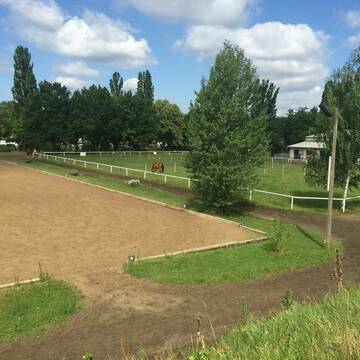
Pferderesidenz Rehfelde
@Pferderesidenz-Rehfelde
FN-Mitglied
Freizeitstall
Führanlage
Krankenbox
bedampftes/gewaschenes Heu
Fohlenaufzucht möglich
Außenboxen
Offenstall
23 weitere...
neu
P+
Deprecated: Creation of dynamic property Zend_View_Helper_Ads::$adLink is deprecated in /var/www/stall-frei/htdocs/staging.stall-frei.de/library/Psf/View/Helper/Ads.php on line 108

Das Beste für die Hufe
Mechtersen
STALL-FREIde Marketing
@STALL-FREI-Marketing
Hufschmiede und Hufpfleger in Ihrer Nähe

1 Offenstall Platz Frei
Schöneiche
Hanni Ranch
@HanniRanch
Freizeitstall
Krankenbox
Longierzirkel/Roundpen
Notfallboxen
Offenstall
5 weitere...
P

Offenstall für 2 -3 Pferde an Selbstversorger
Rehfelde OT Zinndorf
Christin Gröbler
@Christin-G
Freizeitstall
Sattelkammer/Sattelschränke
Toilette vorhanden
Offenstall
Selbstversorgung
1 weitere...
P

Aktivstall und Paddockboxen auf Reitanlage
Schöneiche
Reitanlage Schöneiche
@ReitanlageSchoeneiche
Freizeitstall
Pferdeausbildung
Vermieten
Hunde willkommen
Krankenbox
Hufrehe geeignet
Notfallboxen
23 weitere...
P
Pferdeboxen ab 275€
Berlin
BSV-AdW
@BSV-AdW
FN-Mitglied
Freizeitstall
Vermieten
Führanlage
Hunde willkommen
Hufrehe geeignet
21 weitere...
P


Offenstallplätze / Paddock Trail Plätze frei
Trebbin
Pferdehof Glau GmbH
@Pferdehof-Glau
FN-Mitglied
Freizeitstall
Hunde willkommen
Krankenbox
Allergikerstall
Hufrehe geeignet
Bewegungsstall
Laufstall
24 weitere...
S


Pferdepension Katrin Novak
Altlandsberg
Katrin Novak
@katrin-novak
Freizeitstall
Vermieten
Krankenbox
Longierzirkel/Roundpen
Notfallboxen
9 weitere...
P+
Leider kein Vorschaubild
Leider kein Vorschaubild
Yellow Rose Pferdepension Zossen
Zossen
Torsten Kniesigk
@TorstenKniesigk
Freizeitstall
Vermieten
Hunde willkommen
Krankenbox
Allergikerstall
bedampftes/gewaschenes Heu
18 weitere...
B

Job gesucht?
Mechtersen
STALL-FREIde Marketing
@STALL-FREI-Marketing
Sie suchen einen Job und arbeiten gerne mit Pferden oder auf Reitanlagen?
Besuchen Sie jetzt unseren Stellenmarkt!

Offenstallplätze für leichtfüttrige Ponys bis 1,...
Jühnsdorf
Katis "HORSE CARE"
@KatisHorseCare
Freizeitstall
Gangpferdereiten
Verpachten
Hunde willkommen
Krankenbox
Gnadenbrothof
Hufrehe geeignet
18 weitere...
P

Box frei
Saalow/ Am Mellensee
Dr. Dirk-Henner Wellershoff
@Reitgut-Saalow
Freizeitstall
Geländestrecke
Vermieten
Hunde willkommen
Krankenbox
Hufrehe geeignet
Notfallboxen
26 weitere...
P
Veröffentliche deine Suche als Gesuch und Suchauftrag, dann erhältst du Angebote, neue Treffer und Änderungen per E-Mail.
Diese Suche als Gesuch veröffentlichenDeprecated: Creation of dynamic property Zend_View::$pageCount is deprecated in /var/www/stall-frei/htdocs/staging.stall-frei.de/library/vendor/shardj/zf1-future/library/Zend/View/Abstract.php on line 308
Deprecated: Creation of dynamic property Zend_View::$itemCountPerPage is deprecated in /var/www/stall-frei/htdocs/staging.stall-frei.de/library/vendor/shardj/zf1-future/library/Zend/View/Abstract.php on line 308
Deprecated: Creation of dynamic property Zend_View::$first is deprecated in /var/www/stall-frei/htdocs/staging.stall-frei.de/library/vendor/shardj/zf1-future/library/Zend/View/Abstract.php on line 308
Deprecated: Creation of dynamic property Zend_View::$current is deprecated in /var/www/stall-frei/htdocs/staging.stall-frei.de/library/vendor/shardj/zf1-future/library/Zend/View/Abstract.php on line 308
Deprecated: Creation of dynamic property Zend_View::$last is deprecated in /var/www/stall-frei/htdocs/staging.stall-frei.de/library/vendor/shardj/zf1-future/library/Zend/View/Abstract.php on line 308
Deprecated: Creation of dynamic property Zend_View::$previous is deprecated in /var/www/stall-frei/htdocs/staging.stall-frei.de/library/vendor/shardj/zf1-future/library/Zend/View/Abstract.php on line 308
Deprecated: Creation of dynamic property Zend_View::$next is deprecated in /var/www/stall-frei/htdocs/staging.stall-frei.de/library/vendor/shardj/zf1-future/library/Zend/View/Abstract.php on line 308
Deprecated: Creation of dynamic property Zend_View::$pagesInRange is deprecated in /var/www/stall-frei/htdocs/staging.stall-frei.de/library/vendor/shardj/zf1-future/library/Zend/View/Abstract.php on line 308
Deprecated: Creation of dynamic property Zend_View::$firstPageInRange is deprecated in /var/www/stall-frei/htdocs/staging.stall-frei.de/library/vendor/shardj/zf1-future/library/Zend/View/Abstract.php on line 308
Deprecated: Creation of dynamic property Zend_View::$lastPageInRange is deprecated in /var/www/stall-frei/htdocs/staging.stall-frei.de/library/vendor/shardj/zf1-future/library/Zend/View/Abstract.php on line 308
Deprecated: Creation of dynamic property Zend_View::$currentItemCount is deprecated in /var/www/stall-frei/htdocs/staging.stall-frei.de/library/vendor/shardj/zf1-future/library/Zend/View/Abstract.php on line 308
Deprecated: Creation of dynamic property Zend_View::$totalItemCount is deprecated in /var/www/stall-frei/htdocs/staging.stall-frei.de/library/vendor/shardj/zf1-future/library/Zend/View/Abstract.php on line 308
Deprecated: Creation of dynamic property Zend_View::$firstItemNumber is deprecated in /var/www/stall-frei/htdocs/staging.stall-frei.de/library/vendor/shardj/zf1-future/library/Zend/View/Abstract.php on line 308
Deprecated: Creation of dynamic property Zend_View::$lastItemNumber is deprecated in /var/www/stall-frei/htdocs/staging.stall-frei.de/library/vendor/shardj/zf1-future/library/Zend/View/Abstract.php on line 308
Deprecated: Creation of dynamic property Zend_View::$router is deprecated in /var/www/stall-frei/htdocs/staging.stall-frei.de/library/vendor/shardj/zf1-future/library/Zend/View/Abstract.php on line 308
Deprecated: Creation of dynamic property Zend_View::$urlParams is deprecated in /var/www/stall-frei/htdocs/staging.stall-frei.de/library/vendor/shardj/zf1-future/library/Zend/View/Abstract.php on line 308
Deprecated: Creation of dynamic property Zend_View::$showAds is deprecated in /var/www/stall-frei/htdocs/staging.stall-frei.de/library/vendor/shardj/zf1-future/library/Zend/View/Abstract.php on line 308
Deprecated: Creation of dynamic property Zend_View::$objectIds is deprecated in /var/www/stall-frei/htdocs/staging.stall-frei.de/library/vendor/shardj/zf1-future/library/Zend/View/Abstract.php on line 308
Deprecated: Creation of dynamic property Zend_View::$showNavbar is deprecated in /var/www/stall-frei/htdocs/staging.stall-frei.de/library/vendor/shardj/zf1-future/library/Zend/View/Abstract.php on line 308
Deprecated: Creation of dynamic property Zend_View::$showBreadcrumb is deprecated in /var/www/stall-frei/htdocs/staging.stall-frei.de/library/vendor/shardj/zf1-future/library/Zend/View/Abstract.php on line 308
Deprecated: Creation of dynamic property Zend_View::$showFooter is deprecated in /var/www/stall-frei/htdocs/staging.stall-frei.de/library/vendor/shardj/zf1-future/library/Zend/View/Abstract.php on line 308
Deprecated: Creation of dynamic property Zend_View::$showInternalAds is deprecated in /var/www/stall-frei/htdocs/staging.stall-frei.de/library/vendor/shardj/zf1-future/library/Zend/View/Abstract.php on line 308
Deprecated: Creation of dynamic property Zend_View::$blNoContent is deprecated in /var/www/stall-frei/htdocs/staging.stall-frei.de/library/vendor/shardj/zf1-future/library/Zend/View/Abstract.php on line 308
Deprecated: Creation of dynamic property Zend_View::$sMetaDesc is deprecated in /var/www/stall-frei/htdocs/staging.stall-frei.de/library/vendor/shardj/zf1-future/library/Zend/View/Abstract.php on line 308
Deprecated: Creation of dynamic property Zend_View::$useGmaps is deprecated in /var/www/stall-frei/htdocs/staging.stall-frei.de/library/vendor/shardj/zf1-future/library/Zend/View/Abstract.php on line 308
Deprecated: Creation of dynamic property Zend_View::$touches is deprecated in /var/www/stall-frei/htdocs/staging.stall-frei.de/library/vendor/shardj/zf1-future/library/Zend/View/Abstract.php on line 308
Deprecated: Creation of dynamic property Zend_View::$oProject is deprecated in /var/www/stall-frei/htdocs/staging.stall-frei.de/library/vendor/shardj/zf1-future/library/Zend/View/Abstract.php on line 308
Deprecated: Creation of dynamic property Zend_View::$pageHeadline is deprecated in /var/www/stall-frei/htdocs/staging.stall-frei.de/library/vendor/shardj/zf1-future/library/Zend/View/Abstract.php on line 308
Deprecated: Creation of dynamic property Zend_View::$disableLocationField is deprecated in /var/www/stall-frei/htdocs/staging.stall-frei.de/library/vendor/shardj/zf1-future/library/Zend/View/Abstract.php on line 308
Deprecated: Creation of dynamic property Zend_View::$isSearch is deprecated in /var/www/stall-frei/htdocs/staging.stall-frei.de/library/vendor/shardj/zf1-future/library/Zend/View/Abstract.php on line 308
Deprecated: Creation of dynamic property Zend_View::$pageTitle is deprecated in /var/www/stall-frei/htdocs/staging.stall-frei.de/library/vendor/shardj/zf1-future/library/Zend/View/Abstract.php on line 308
Deprecated: Creation of dynamic property Psf_Form_Element_Text::$class is deprecated in /var/www/stall-frei/htdocs/staging.stall-frei.de/library/vendor/shardj/zf1-future/library/Zend/Form/Element.php on line 874
Deprecated: Creation of dynamic property Psf_Form_Element_Text::$size is deprecated in /var/www/stall-frei/htdocs/staging.stall-frei.de/library/vendor/shardj/zf1-future/library/Zend/Form/Element.php on line 874
Deprecated: Creation of dynamic property Psf_Form_Element_Text::$placeholder is deprecated in /var/www/stall-frei/htdocs/staging.stall-frei.de/library/vendor/shardj/zf1-future/library/Zend/Form/Element.php on line 874
Deprecated: Creation of dynamic property Psf_Form_Element_Hidden::$class is deprecated in /var/www/stall-frei/htdocs/staging.stall-frei.de/library/vendor/shardj/zf1-future/library/Zend/Form/Element.php on line 874
Deprecated: Creation of dynamic property Psf_Form_Element_Hidden::$class is deprecated in /var/www/stall-frei/htdocs/staging.stall-frei.de/library/vendor/shardj/zf1-future/library/Zend/Form/Element.php on line 874
Deprecated: Creation of dynamic property Psf_Form_Element_Hidden::$class is deprecated in /var/www/stall-frei/htdocs/staging.stall-frei.de/library/vendor/shardj/zf1-future/library/Zend/Form/Element.php on line 874
Deprecated: Creation of dynamic property Psf_Form_Element_Hidden::$class is deprecated in /var/www/stall-frei/htdocs/staging.stall-frei.de/library/vendor/shardj/zf1-future/library/Zend/Form/Element.php on line 874
Deprecated: Creation of dynamic property Psf_Form_Element_Select::$class is deprecated in /var/www/stall-frei/htdocs/staging.stall-frei.de/library/vendor/shardj/zf1-future/library/Zend/Form/Element.php on line 874
Deprecated: Creation of dynamic property Psf_Form_Element_Select::$class is deprecated in /var/www/stall-frei/htdocs/staging.stall-frei.de/library/vendor/shardj/zf1-future/library/Zend/Form/Element.php on line 874
Deprecated: Creation of dynamic property Psf_Form_Element_Select::$class is deprecated in /var/www/stall-frei/htdocs/staging.stall-frei.de/library/vendor/shardj/zf1-future/library/Zend/Form/Element.php on line 874
Deprecated: Creation of dynamic property Psf_Form_Element_Select::$class is deprecated in /var/www/stall-frei/htdocs/staging.stall-frei.de/library/vendor/shardj/zf1-future/library/Zend/Form/Element.php on line 874
Deprecated: Creation of dynamic property Psf_Form_Element_Text::$class is deprecated in /var/www/stall-frei/htdocs/staging.stall-frei.de/library/vendor/shardj/zf1-future/library/Zend/Form/Element.php on line 874
Deprecated: Creation of dynamic property Psf_Form_Element_Checkbox::$label is deprecated in /var/www/stall-frei/htdocs/staging.stall-frei.de/library/vendor/shardj/zf1-future/library/Zend/Form/Element.php on line 874
Deprecated: Creation of dynamic property Zend_View::$sort is deprecated in /var/www/stall-frei/htdocs/staging.stall-frei.de/library/vendor/shardj/zf1-future/library/Zend/View/Abstract.php on line 308
Deprecated: Creation of dynamic property Zend_View::$searchLocation is deprecated in /var/www/stall-frei/htdocs/staging.stall-frei.de/library/vendor/shardj/zf1-future/library/Zend/View/Abstract.php on line 308
Deprecated: Creation of dynamic property Zend_View::$locationHint is deprecated in /var/www/stall-frei/htdocs/staging.stall-frei.de/library/vendor/shardj/zf1-future/library/Zend/View/Abstract.php on line 308
Psf_GeoCoder_Abstract::getLocation: Kolberg Get Location CachedOrLive
Psf_GeoCoder_Abstract::getCachedOrLive: Kolberg
Psf_GeoCoder_Abstract::convertLocationResult
{"documentation":"https:\/\/opencagedata.com\/api","licenses":[{"name":"see attribution guide","url":"https:\/\/opencagedata.com\/credits"}],"results":[{"bounds":{"northeast":{"lat":52.2526047,"lng":13.8276755},"southwest":{"lat":52.2271127,"lng":13.7701066}},"components":{"ISO_3166-1_alpha-2":"DE","ISO_3166-1_alpha-3":"DEU","ISO_3166-2":["DE-BB"],"_category":"place","_normalized_city":"Kolberg","_type":"village","continent":"Europe","country":"Deutschland","country_code":"de","county":"Dahme-Spreewald","municipality":"Heidesee","political_union":"European Union","state":"Brandenburg","state_code":"BB","village":"Kolberg"},"confidence":7,"formatted":"Kolberg, Brandenburg, Deutschland","geometry":{"lat":52.2454378,"lng":13.8043576}},{"bounds":{"northeast":{"lat":51.2931556,"lng":7.7267602},"southwest":{"lat":51.2930556,"lng":7.7266602}},"components":{"ISO_3166-1_alpha-2":"DE","ISO_3166-1_alpha-3":"DEU","ISO_3166-2":["DE-NW"],"_category":"natural\/water","_normalized_city":"Altena","_type":"peak","continent":"Europe","country":"Deutschland","country_code":"de","county":"M\u00e4rkischer Kreis","peak":"Kolberg","political_union":"European Union","postcode":"58762","state":"Nordrhein-Westfalen","state_code":"NW","town":"Altena"},"confidence":9,"formatted":"Kolberg, 58762 Altena, Deutschland","geometry":{"lat":51.2931056,"lng":7.7267102}},{"bounds":{"northeast":{"lat":52.2392258,"lng":13.8146182},"southwest":{"lat":52.2391258,"lng":13.8145182}},"components":{"ISO_3166-1_alpha-2":"DE","ISO_3166-1_alpha-3":"DEU","ISO_3166-2":["DE-BB"],"_category":"natural\/water","_normalized_city":"Kolberg","_type":"peak","continent":"Europe","country":"Deutschland","country_code":"de","county":"Dahme-Spreewald","municipality":"Heidesee","peak":"Kolberg","political_union":"European Union","postcode":"15754","state":"Brandenburg","state_code":"BB","village":"Kolberg"},"confidence":9,"formatted":"Kolberg, 15754 Kolberg, Deutschland","geometry":{"lat":52.2391758,"lng":13.8145682}},{"bounds":{"northeast":{"lat":51.4080085,"lng":10.9221351},"southwest":{"lat":51.4079085,"lng":10.9220351}},"components":{"ISO_3166-1_alpha-2":"DE","ISO_3166-1_alpha-3":"DEU","ISO_3166-2":["DE-TH"],"_category":"natural\/water","_normalized_city":"Heringen\/Helme","_type":"peak","continent":"Europe","country":"Deutschland","country_code":"de","county":"Landkreis Nordhausen","municipality":"Heringen\/Helme","peak":"Kolberg","political_union":"European Union","state":"Th\u00fcringen","state_code":"TH","town":"Heringen\/Helme"},"confidence":9,"formatted":"Kolberg, Heringen\/Helme, Th\u00fcringen, Deutschland","geometry":{"lat":51.4079585,"lng":10.9220851}},{"bounds":{"northeast":{"lat":47.8911781,"lng":12.0699639},"southwest":{"lat":47.8893322,"lng":12.0658043}},"components":{"ISO_3166-1_alpha-2":"DE","ISO_3166-1_alpha-3":"DEU","ISO_3166-2":["DE-BY"],"_category":"place","_normalized_city":"Gro\u00dfkarolinenfeld","_type":"hamlet","continent":"Europe","country":"Deutschland","country_code":"de","county":"Landkreis Rosenheim","hamlet":"Kolberg","political_union":"European Union","state":"Bayern","state_code":"BY","village":"Gro\u00dfkarolinenfeld"},"confidence":9,"formatted":"Kolberg, Gro\u00dfkarolinenfeld, Bayern, Deutschland","geometry":{"lat":47.890442,"lng":12.0682348}},{"bounds":{"northeast":{"lat":54.2664723,"lng":10.0756937},"southwest":{"lat":54.2651433,"lng":10.0685864}},"components":{"ISO_3166-1_alpha-2":"DE","ISO_3166-1_alpha-3":"DEU","ISO_3166-2":["DE-SH"],"_category":"road","_normalized_city":"Molfsee","_type":"road","continent":"Europe","country":"Deutschland","country_code":"de","county":"Kreis Rendsburg-Eckernf\u00f6rde","municipality":"Molfsee","political_union":"European Union","postcode":"24113","road":"Kolberg","road_type":"residential","state":"Schleswig-Holstein","state_code":"SH"},"confidence":9,"formatted":"Kolberg, 24113 Molfsee, Deutschland","geometry":{"lat":54.2651859,"lng":10.0720202}},{"bounds":{"northeast":{"lat":51.1282333,"lng":9.5382125},"southwest":{"lat":51.1276096,"lng":9.5361032}},"components":{"ISO_3166-1_alpha-2":"DE","ISO_3166-1_alpha-3":"DEU","ISO_3166-2":["DE-HE"],"_category":"road","_normalized_city":"Melsungen","_type":"road","continent":"Europe","country":"Deutschland","country_code":"de","county":"Schwalm-Eder-Kreis","municipality":"Melsungen","political_union":"European Union","postcode":"34212","road":"Kolberg","road_type":"residential","state":"Hessen","state_code":"HE","town":"Melsungen"},"confidence":9,"formatted":"Kolberg, 34212 Melsungen, Deutschland","geometry":{"lat":51.1282012,"lng":9.5372621}},{"bounds":{"northeast":{"lat":52.1884862,"lng":13.0462315},"southwest":{"lat":52.1883862,"lng":13.0461315}},"components":{"ISO_3166-1_alpha-2":"DE","ISO_3166-1_alpha-3":"DEU","ISO_3166-2":["DE-BB"],"_category":"natural\/water","_normalized_city":"Rieben","_type":"peak","continent":"Europe","country":"Deutschland","country_code":"de","county":"Potsdam-Mittelmark","municipality":"Beelitz","peak":"Kolberg","political_union":"European Union","state":"Brandenburg","state_code":"BB","village":"Rieben"},"confidence":9,"formatted":"Kolberg, Rieben, Brandenburg, Deutschland","geometry":{"lat":52.1884362,"lng":13.0461815}},{"bounds":{"northeast":{"lat":48.496292,"lng":13.044849},"southwest":{"lat":48.476292,"lng":13.024849}},"components":{"ISO_3166-1_alpha-2":"DE","ISO_3166-1_alpha-3":"DEU","ISO_3166-2":["DE-BY"],"_category":"agriculture","_normalized_city":"Dietersburg","_type":"farm","continent":"Europe","country":"Deutschland","country_code":"de","county":"Landkreis Rottal-Inn","farm":"K\u00f6lberg","political_union":"European Union","postcode":"84378","state":"Bayern","state_code":"BY","village":"Dietersburg"},"confidence":8,"formatted":"K\u00f6lberg, 84378 Dietersburg, Deutschland","geometry":{"lat":48.486292,"lng":13.034849}},{"components":{"ISO_3166-1_alpha-2":"FR","ISO_3166-1_alpha-3":"FRA","ISO_3166-2":["FR-IDF","FR-77"],"_category":"road","_normalized_city":"Meaux","_type":"road","city":"Meaux","continent":"Europe","country":"France","country_code":"fr","county":"Seine-et-Marne","local_authority":"Communaut\u00e9 d'agglom\u00e9ration du Pays de Meaux","political_union":"European Union","postcode":"77100","road":"Place Colbert","state":"\u00cele-de-France","state_code":"IDF"},"confidence":2,"formatted":"Place Colbert, 77100 Meaux, France","geometry":{"lat":48.949942,"lng":2.905002}}],"status":{"code":200,"message":"OK"},"stay_informed":{"blog":"https:\/\/blog.opencagedata.com","mastodon":"https:\/\/en.osm.town\/@opencage"},"thanks":"For using an OpenCage API","timestamp":{"created_http":"Sat, 07 Feb 2026 14:22:17 GMT","created_unix":1770474137},"total_results":10}Array
(
[0] => stdClass Object
(
[bounds] => stdClass Object
(
[northeast] => stdClass Object
(
[lat] => 52.2526047
[lng] => 13.8276755
)
[southwest] => stdClass Object
(
[lat] => 52.2271127
[lng] => 13.7701066
)
)
[components] => stdClass Object
(
[ISO_3166-1_alpha-2] => DE
[ISO_3166-1_alpha-3] => DEU
[ISO_3166-2] => Array
(
[0] => DE-BB
)
[_category] => place
[_normalized_city] => Kolberg
[_type] => village
[continent] => Europe
[country] => Deutschland
[country_code] => de
[county] => Dahme-Spreewald
[municipality] => Heidesee
[political_union] => European Union
[state] => Brandenburg
[state_code] => BB
[village] => Kolberg
)
[confidence] => 7
[formatted] => Kolberg, Brandenburg, Deutschland
[geometry] => stdClass Object
(
[lat] => 52.2454378
[lng] => 13.8043576
)
)
[1] => stdClass Object
(
[bounds] => stdClass Object
(
[northeast] => stdClass Object
(
[lat] => 51.2931556
[lng] => 7.7267602
)
[southwest] => stdClass Object
(
[lat] => 51.2930556
[lng] => 7.7266602
)
)
[components] => stdClass Object
(
[ISO_3166-1_alpha-2] => DE
[ISO_3166-1_alpha-3] => DEU
[ISO_3166-2] => Array
(
[0] => DE-NW
)
[_category] => natural/water
[_normalized_city] => Altena
[_type] => peak
[continent] => Europe
[country] => Deutschland
[country_code] => de
[county] => Märkischer Kreis
[peak] => Kolberg
[political_union] => European Union
[postcode] => 58762
[state] => Nordrhein-Westfalen
[state_code] => NW
[town] => Altena
)
[confidence] => 9
[formatted] => Kolberg, 58762 Altena, Deutschland
[geometry] => stdClass Object
(
[lat] => 51.2931056
[lng] => 7.7267102
)
)
[2] => stdClass Object
(
[bounds] => stdClass Object
(
[northeast] => stdClass Object
(
[lat] => 52.2392258
[lng] => 13.8146182
)
[southwest] => stdClass Object
(
[lat] => 52.2391258
[lng] => 13.8145182
)
)
[components] => stdClass Object
(
[ISO_3166-1_alpha-2] => DE
[ISO_3166-1_alpha-3] => DEU
[ISO_3166-2] => Array
(
[0] => DE-BB
)
[_category] => natural/water
[_normalized_city] => Kolberg
[_type] => peak
[continent] => Europe
[country] => Deutschland
[country_code] => de
[county] => Dahme-Spreewald
[municipality] => Heidesee
[peak] => Kolberg
[political_union] => European Union
[postcode] => 15754
[state] => Brandenburg
[state_code] => BB
[village] => Kolberg
)
[confidence] => 9
[formatted] => Kolberg, 15754 Kolberg, Deutschland
[geometry] => stdClass Object
(
[lat] => 52.2391758
[lng] => 13.8145682
)
)
[3] => stdClass Object
(
[bounds] => stdClass Object
(
[northeast] => stdClass Object
(
[lat] => 51.4080085
[lng] => 10.9221351
)
[southwest] => stdClass Object
(
[lat] => 51.4079085
[lng] => 10.9220351
)
)
[components] => stdClass Object
(
[ISO_3166-1_alpha-2] => DE
[ISO_3166-1_alpha-3] => DEU
[ISO_3166-2] => Array
(
[0] => DE-TH
)
[_category] => natural/water
[_normalized_city] => Heringen/Helme
[_type] => peak
[continent] => Europe
[country] => Deutschland
[country_code] => de
[county] => Landkreis Nordhausen
[municipality] => Heringen/Helme
[peak] => Kolberg
[political_union] => European Union
[state] => Thüringen
[state_code] => TH
[town] => Heringen/Helme
)
[confidence] => 9
[formatted] => Kolberg, Heringen/Helme, Thüringen, Deutschland
[geometry] => stdClass Object
(
[lat] => 51.4079585
[lng] => 10.9220851
)
)
[4] => stdClass Object
(
[bounds] => stdClass Object
(
[northeast] => stdClass Object
(
[lat] => 47.8911781
[lng] => 12.0699639
)
[southwest] => stdClass Object
(
[lat] => 47.8893322
[lng] => 12.0658043
)
)
[components] => stdClass Object
(
[ISO_3166-1_alpha-2] => DE
[ISO_3166-1_alpha-3] => DEU
[ISO_3166-2] => Array
(
[0] => DE-BY
)
[_category] => place
[_normalized_city] => Großkarolinenfeld
[_type] => hamlet
[continent] => Europe
[country] => Deutschland
[country_code] => de
[county] => Landkreis Rosenheim
[hamlet] => Kolberg
[political_union] => European Union
[state] => Bayern
[state_code] => BY
[village] => Großkarolinenfeld
)
[confidence] => 9
[formatted] => Kolberg, Großkarolinenfeld, Bayern, Deutschland
[geometry] => stdClass Object
(
[lat] => 47.890442
[lng] => 12.0682348
)
)
[5] => stdClass Object
(
[bounds] => stdClass Object
(
[northeast] => stdClass Object
(
[lat] => 54.2664723
[lng] => 10.0756937
)
[southwest] => stdClass Object
(
[lat] => 54.2651433
[lng] => 10.0685864
)
)
[components] => stdClass Object
(
[ISO_3166-1_alpha-2] => DE
[ISO_3166-1_alpha-3] => DEU
[ISO_3166-2] => Array
(
[0] => DE-SH
)
[_category] => road
[_normalized_city] => Molfsee
[_type] => road
[continent] => Europe
[country] => Deutschland
[country_code] => de
[county] => Kreis Rendsburg-Eckernförde
[municipality] => Molfsee
[political_union] => European Union
[postcode] => 24113
[road] => Kolberg
[road_type] => residential
[state] => Schleswig-Holstein
[state_code] => SH
)
[confidence] => 9
[formatted] => Kolberg, 24113 Molfsee, Deutschland
[geometry] => stdClass Object
(
[lat] => 54.2651859
[lng] => 10.0720202
)
)
[6] => stdClass Object
(
[bounds] => stdClass Object
(
[northeast] => stdClass Object
(
[lat] => 51.1282333
[lng] => 9.5382125
)
[southwest] => stdClass Object
(
[lat] => 51.1276096
[lng] => 9.5361032
)
)
[components] => stdClass Object
(
[ISO_3166-1_alpha-2] => DE
[ISO_3166-1_alpha-3] => DEU
[ISO_3166-2] => Array
(
[0] => DE-HE
)
[_category] => road
[_normalized_city] => Melsungen
[_type] => road
[continent] => Europe
[country] => Deutschland
[country_code] => de
[county] => Schwalm-Eder-Kreis
[municipality] => Melsungen
[political_union] => European Union
[postcode] => 34212
[road] => Kolberg
[road_type] => residential
[state] => Hessen
[state_code] => HE
[town] => Melsungen
)
[confidence] => 9
[formatted] => Kolberg, 34212 Melsungen, Deutschland
[geometry] => stdClass Object
(
[lat] => 51.1282012
[lng] => 9.5372621
)
)
[7] => stdClass Object
(
[bounds] => stdClass Object
(
[northeast] => stdClass Object
(
[lat] => 52.1884862
[lng] => 13.0462315
)
[southwest] => stdClass Object
(
[lat] => 52.1883862
[lng] => 13.0461315
)
)
[components] => stdClass Object
(
[ISO_3166-1_alpha-2] => DE
[ISO_3166-1_alpha-3] => DEU
[ISO_3166-2] => Array
(
[0] => DE-BB
)
[_category] => natural/water
[_normalized_city] => Rieben
[_type] => peak
[continent] => Europe
[country] => Deutschland
[country_code] => de
[county] => Potsdam-Mittelmark
[municipality] => Beelitz
[peak] => Kolberg
[political_union] => European Union
[state] => Brandenburg
[state_code] => BB
[village] => Rieben
)
[confidence] => 9
[formatted] => Kolberg, Rieben, Brandenburg, Deutschland
[geometry] => stdClass Object
(
[lat] => 52.1884362
[lng] => 13.0461815
)
)
[8] => stdClass Object
(
[bounds] => stdClass Object
(
[northeast] => stdClass Object
(
[lat] => 48.496292
[lng] => 13.044849
)
[southwest] => stdClass Object
(
[lat] => 48.476292
[lng] => 13.024849
)
)
[components] => stdClass Object
(
[ISO_3166-1_alpha-2] => DE
[ISO_3166-1_alpha-3] => DEU
[ISO_3166-2] => Array
(
[0] => DE-BY
)
[_category] => agriculture
[_normalized_city] => Dietersburg
[_type] => farm
[continent] => Europe
[country] => Deutschland
[country_code] => de
[county] => Landkreis Rottal-Inn
[farm] => Kölberg
[political_union] => European Union
[postcode] => 84378
[state] => Bayern
[state_code] => BY
[village] => Dietersburg
)
[confidence] => 8
[formatted] => Kölberg, 84378 Dietersburg, Deutschland
[geometry] => stdClass Object
(
[lat] => 48.486292
[lng] => 13.034849
)
)
[9] => stdClass Object
(
[components] => stdClass Object
(
[ISO_3166-1_alpha-2] => FR
[ISO_3166-1_alpha-3] => FRA
[ISO_3166-2] => Array
(
[0] => FR-IDF
[1] => FR-77
)
[_category] => road
[_normalized_city] => Meaux
[_type] => road
[city] => Meaux
[continent] => Europe
[country] => France
[country_code] => fr
[county] => Seine-et-Marne
[local_authority] => Communauté d'agglomération du Pays de Meaux
[political_union] => European Union
[postcode] => 77100
[road] => Place Colbert
[state] => Île-de-France
[state_code] => IDF
)
[confidence] => 2
[formatted] => Place Colbert, 77100 Meaux, France
[geometry] => stdClass Object
(
[lat] => 48.949942
[lng] => 2.905002
)
)
)
Psf_GeoCoder_OpenCageData::getKeyMap: 0
stdClass Object
(
    [bounds] => stdClass Object
        (
            [northeast] => stdClass Object
                (
                    [lat] => 52.2526047
                    [lng] => 13.8276755
                )

            [southwest] => stdClass Object
                (
                    [lat] => 52.2271127
                    [lng] => 13.7701066
                )

        )

    [components] => stdClass Object
        (
            [ISO_3166-1_alpha-2] => DE
            [ISO_3166-1_alpha-3] => DEU
            [ISO_3166-2] => Array
                (
                    [0] => DE-BB
                )

            [_category] => place
            [_normalized_city] => Kolberg
            [_type] => village
            [continent] => Europe
            [country] => Deutschland
            [country_code] => de
            [county] => Dahme-Spreewald
            [municipality] => Heidesee
            [political_union] => European Union
            [state] => Brandenburg
            [state_code] => BB
            [village] => Kolberg
        )

    [confidence] => 7
    [formatted] => Kolberg, Brandenburg, Deutschland
    [geometry] => stdClass Object
        (
            [lat] => 52.2454378
            [lng] => 13.8043576
        )

)
Psf_GeoCoder_OpenCageData::getCounty: Dahme-Spreewald
Psf_GeoCoder_OpenCageData::addMissingData REFETCH!
Array
(
    [address] => Kolberg, Brandenburg, Deutschland
    [type] => village
    [street] =>
    [city] => Kolberg
    [county] => Dahme-Spreewald
    [state] => Brandenburg
    [zip] =>
    [country] => Deutschland
    [suburb] =>
    [countrycode] => de
    [latitude] => 52.2454378
    [longitude] => 13.8043576
    [accuracy] => 1
    [confidence] => 7
    [bounds] => stdClass Object
        (
            [northeast] => stdClass Object
                (
                    [lat] => 52.2526047
                    [lng] => 13.8276755
                )

            [southwest] => stdClass Object
                (
                    [lat] => 52.2271127
                    [lng] => 13.7701066
                )

        )

)
reformat!
Array
(
    [address] => Kolberg, Brandenburg, Deutschland
    [type] => village
    [street] =>
    [city] => Kolberg
    [county] => Dahme-Spreewald
    [state] => Brandenburg
    [zip] =>
    [country] => Deutschland
    [suburb] =>
    [countrycode] => de
    [latitude] => 52.2454378
    [longitude] => 13.8043576
    [accuracy] => 1
    [confidence] => 7
    [bounds] => stdClass Object
        (
            [northeast] => stdClass Object
                (
                    [lat] => 52.2526047
                    [lng] => 13.8276755
                )

            [southwest] => stdClass Object
                (
                    [lat] => 52.2271127
                    [lng] => 13.7701066
                )

        )

    [place] => Kolberg, Brandenburg
    [hash] => 55e27d72233d8df30dc00e6ed2000d0d
)
Psf_GeoCoder_OpenCageData::getKeyMap: 1
stdClass Object
(
    [bounds] => stdClass Object
        (
            [northeast] => stdClass Object
                (
                    [lat] => 51.2931556
                    [lng] => 7.7267602
                )

            [southwest] => stdClass Object
                (
                    [lat] => 51.2930556
                    [lng] => 7.7266602
                )

        )

    [components] => stdClass Object
        (
            [ISO_3166-1_alpha-2] => DE
            [ISO_3166-1_alpha-3] => DEU
            [ISO_3166-2] => Array
                (
                    [0] => DE-NW
                )

            [_category] => natural/water
            [_normalized_city] => Altena
            [_type] => peak
            [continent] => Europe
            [country] => Deutschland
            [country_code] => de
            [county] => Märkischer Kreis
            [peak] => Kolberg
            [political_union] => European Union
            [postcode] => 58762
            [state] => Nordrhein-Westfalen
            [state_code] => NW
            [town] => Altena
        )

    [confidence] => 9
    [formatted] => Kolberg, 58762 Altena, Deutschland
    [geometry] => stdClass Object
        (
            [lat] => 51.2931056
            [lng] => 7.7267102
        )

)
Psf_GeoCoder_OpenCageData::getCounty: Märkischer Kreis
Psf_GeoCoder_OpenCageData::addMissingData REFETCH!
Array
(
    [address] => Kolberg, 58762 Altena, Deutschland
    [type] => peak
    [street] =>
    [city] => Altena
    [county] => Märkischer Kreis
    [state] => Nordrhein-Westfalen
    [zip] => 58762
    [country] => Deutschland
    [suburb] =>
    [countrycode] => de
    [latitude] => 51.2931056
    [longitude] => 7.7267102
    [accuracy] => 1
    [confidence] => 9
    [bounds] => stdClass Object
        (
            [northeast] => stdClass Object
                (
                    [lat] => 51.2931556
                    [lng] => 7.7267602
                )

            [southwest] => stdClass Object
                (
                    [lat] => 51.2930556
                    [lng] => 7.7266602
                )

        )

)
reformat!
Array
(
    [address] => Kolberg, 58762 Altena, Deutschland
    [type] => peak
    [street] =>
    [city] => Altena
    [county] => Märkischer Kreis
    [state] => Nordrhein-Westfalen
    [zip] => 58762
    [country] => Deutschland
    [suburb] =>
    [countrycode] => de
    [latitude] => 51.2931056
    [longitude] => 7.7267102
    [accuracy] => 1
    [confidence] => 9
    [bounds] => stdClass Object
        (
            [northeast] => stdClass Object
                (
                    [lat] => 51.2931556
                    [lng] => 7.7267602
                )

            [southwest] => stdClass Object
                (
                    [lat] => 51.2930556
                    [lng] => 7.7266602
                )

        )

    [place] => 58762 Altena, Nordrhein-Westfalen
    [hash] => 924d366eeebf4658172a26645b4e20dc
)
Psf_GeoCoder_OpenCageData::getKeyMap: 2
stdClass Object
(
    [bounds] => stdClass Object
        (
            [northeast] => stdClass Object
                (
                    [lat] => 52.2392258
                    [lng] => 13.8146182
                )

            [southwest] => stdClass Object
                (
                    [lat] => 52.2391258
                    [lng] => 13.8145182
                )

        )

    [components] => stdClass Object
        (
            [ISO_3166-1_alpha-2] => DE
            [ISO_3166-1_alpha-3] => DEU
            [ISO_3166-2] => Array
                (
                    [0] => DE-BB
                )

            [_category] => natural/water
            [_normalized_city] => Kolberg
            [_type] => peak
            [continent] => Europe
            [country] => Deutschland
            [country_code] => de
            [county] => Dahme-Spreewald
            [municipality] => Heidesee
            [peak] => Kolberg
            [political_union] => European Union
            [postcode] => 15754
            [state] => Brandenburg
            [state_code] => BB
            [village] => Kolberg
        )

    [confidence] => 9
    [formatted] => Kolberg, 15754 Kolberg, Deutschland
    [geometry] => stdClass Object
        (
            [lat] => 52.2391758
            [lng] => 13.8145682
        )

)
Psf_GeoCoder_OpenCageData::getCounty: Dahme-Spreewald
Psf_GeoCoder_OpenCageData::addMissingData REFETCH!
Array
(
    [address] => Kolberg, 15754 Kolberg, Deutschland
    [type] => peak
    [street] =>
    [city] => Kolberg
    [county] => Dahme-Spreewald
    [state] => Brandenburg
    [zip] => 15754
    [country] => Deutschland
    [suburb] =>
    [countrycode] => de
    [latitude] => 52.2391758
    [longitude] => 13.8145682
    [accuracy] => 1
    [confidence] => 9
    [bounds] => stdClass Object
        (
            [northeast] => stdClass Object
                (
                    [lat] => 52.2392258
                    [lng] => 13.8146182
                )

            [southwest] => stdClass Object
                (
                    [lat] => 52.2391258
                    [lng] => 13.8145182
                )

        )

)
reformat!
Array
(
    [address] => Kolberg, 15754 Kolberg, Deutschland
    [type] => peak
    [street] =>
    [city] => Kolberg
    [county] => Dahme-Spreewald
    [state] => Brandenburg
    [zip] => 15754
    [country] => Deutschland
    [suburb] =>
    [countrycode] => de
    [latitude] => 52.2391758
    [longitude] => 13.8145682
    [accuracy] => 1
    [confidence] => 9
    [bounds] => stdClass Object
        (
            [northeast] => stdClass Object
                (
                    [lat] => 52.2392258
                    [lng] => 13.8146182
                )

            [southwest] => stdClass Object
                (
                    [lat] => 52.2391258
                    [lng] => 13.8145182
                )

        )

    [place] => 15754 Kolberg, Brandenburg
    [hash] => d040c717efea2f7cf2ae2d309739980d
)
Psf_GeoCoder_OpenCageData::getKeyMap: 3
stdClass Object
(
    [bounds] => stdClass Object
        (
            [northeast] => stdClass Object
                (
                    [lat] => 51.4080085
                    [lng] => 10.9221351
                )

            [southwest] => stdClass Object
                (
                    [lat] => 51.4079085
                    [lng] => 10.9220351
                )

        )

    [components] => stdClass Object
        (
            [ISO_3166-1_alpha-2] => DE
            [ISO_3166-1_alpha-3] => DEU
            [ISO_3166-2] => Array
                (
                    [0] => DE-TH
                )

            [_category] => natural/water
            [_normalized_city] => Heringen/Helme
            [_type] => peak
            [continent] => Europe
            [country] => Deutschland
            [country_code] => de
            [county] => Landkreis Nordhausen
            [municipality] => Heringen/Helme
            [peak] => Kolberg
            [political_union] => European Union
            [state] => Thüringen
            [state_code] => TH
            [town] => Heringen/Helme
        )

    [confidence] => 9
    [formatted] => Kolberg, Heringen/Helme, Thüringen, Deutschland
    [geometry] => stdClass Object
        (
            [lat] => 51.4079585
            [lng] => 10.9220851
        )

)
Psf_GeoCoder_OpenCageData::getCounty: Nordhausen
Psf_GeoCoder_OpenCageData::addMissingData REFETCH!
Array
(
    [address] => Kolberg, Heringen/Helme, Thüringen, Deutschland
    [type] => peak
    [street] =>
    [city] => Heringen/Helme
    [county] => Nordhausen
    [state] => Thüringen
    [zip] =>
    [country] => Deutschland
    [suburb] =>
    [countrycode] => de
    [latitude] => 51.4079585
    [longitude] => 10.9220851
    [accuracy] => 1
    [confidence] => 9
    [bounds] => stdClass Object
        (
            [northeast] => stdClass Object
                (
                    [lat] => 51.4080085
                    [lng] => 10.9221351
                )

            [southwest] => stdClass Object
                (
                    [lat] => 51.4079085
                    [lng] => 10.9220351
                )

        )

)
reformat!
Array
(
    [address] => Kolberg, Heringen/Helme, Thüringen, Deutschland
    [type] => peak
    [street] =>
    [city] => Heringen/Helme
    [county] => Nordhausen
    [state] => Thüringen
    [zip] =>
    [country] => Deutschland
    [suburb] =>
    [countrycode] => de
    [latitude] => 51.4079585
    [longitude] => 10.9220851
    [accuracy] => 1
    [confidence] => 9
    [bounds] => stdClass Object
        (
            [northeast] => stdClass Object
                (
                    [lat] => 51.4080085
                    [lng] => 10.9221351
                )

            [southwest] => stdClass Object
                (
                    [lat] => 51.4079085
                    [lng] => 10.9220351
                )

        )

    [place] => Heringen/Helme, Thüringen
    [hash] => ab6313e6301b5248bc28433c2e113e70
)
Psf_GeoCoder_OpenCageData::getKeyMap: 4
stdClass Object
(
    [bounds] => stdClass Object
        (
            [northeast] => stdClass Object
                (
                    [lat] => 47.8911781
                    [lng] => 12.0699639
                )

            [southwest] => stdClass Object
                (
                    [lat] => 47.8893322
                    [lng] => 12.0658043
                )

        )

    [components] => stdClass Object
        (
            [ISO_3166-1_alpha-2] => DE
            [ISO_3166-1_alpha-3] => DEU
            [ISO_3166-2] => Array
                (
                    [0] => DE-BY
                )

            [_category] => place
            [_normalized_city] => Großkarolinenfeld
            [_type] => hamlet
            [continent] => Europe
            [country] => Deutschland
            [country_code] => de
            [county] => Landkreis Rosenheim
            [hamlet] => Kolberg
            [political_union] => European Union
            [state] => Bayern
            [state_code] => BY
            [village] => Großkarolinenfeld
        )

    [confidence] => 9
    [formatted] => Kolberg, Großkarolinenfeld, Bayern, Deutschland
    [geometry] => stdClass Object
        (
            [lat] => 47.890442
            [lng] => 12.0682348
        )

)
Psf_GeoCoder_OpenCageData::getCounty: Rosenheim
Psf_GeoCoder_OpenCageData::addMissingData REFETCH!
Array
(
    [address] => Kolberg, Großkarolinenfeld, Bayern, Deutschland
    [type] => hamlet
    [street] => Kolberg
    [city] => Großkarolinenfeld
    [county] => Rosenheim
    [state] => Bayern
    [zip] =>
    [country] => Deutschland
    [suburb] =>
    [countrycode] => de
    [latitude] => 47.890442
    [longitude] => 12.0682348
    [accuracy] => 1
    [confidence] => 9
    [bounds] => stdClass Object
        (
            [northeast] => stdClass Object
                (
                    [lat] => 47.8911781
                    [lng] => 12.0699639
                )

            [southwest] => stdClass Object
                (
                    [lat] => 47.8893322
                    [lng] => 12.0658043
                )

        )

)
reformat!
Array
(
    [address] => Kolberg, Großkarolinenfeld, Bayern, Deutschland
    [type] => hamlet
    [street] => Kolberg
    [city] => Großkarolinenfeld
    [county] => Rosenheim
    [state] => Bayern
    [zip] =>
    [country] => Deutschland
    [suburb] =>
    [countrycode] => de
    [latitude] => 47.890442
    [longitude] => 12.0682348
    [accuracy] => 1
    [confidence] => 9
    [bounds] => stdClass Object
        (
            [northeast] => stdClass Object
                (
                    [lat] => 47.8911781
                    [lng] => 12.0699639
                )

            [southwest] => stdClass Object
                (
                    [lat] => 47.8893322
                    [lng] => 12.0658043
                )

        )

    [place] => Kolberg, Großkarolinenfeld, Bayern
    [hash] => cc7403872cbeaaf143b8e2fa5c6811ea
)
Psf_GeoCoder_OpenCageData::getKeyMap: 5
stdClass Object
(
    [bounds] => stdClass Object
        (
            [northeast] => stdClass Object
                (
                    [lat] => 54.2664723
                    [lng] => 10.0756937
                )

            [southwest] => stdClass Object
                (
                    [lat] => 54.2651433
                    [lng] => 10.0685864
                )

        )

    [components] => stdClass Object
        (
            [ISO_3166-1_alpha-2] => DE
            [ISO_3166-1_alpha-3] => DEU
            [ISO_3166-2] => Array
                (
                    [0] => DE-SH
                )

            [_category] => road
            [_normalized_city] => Molfsee
            [_type] => road
            [continent] => Europe
            [country] => Deutschland
            [country_code] => de
            [county] => Kreis Rendsburg-Eckernförde
            [municipality] => Molfsee
            [political_union] => European Union
            [postcode] => 24113
            [road] => Kolberg
            [road_type] => residential
            [state] => Schleswig-Holstein
            [state_code] => SH
        )

    [confidence] => 9
    [formatted] => Kolberg, 24113 Molfsee, Deutschland
    [geometry] => stdClass Object
        (
            [lat] => 54.2651859
            [lng] => 10.0720202
        )

)
Psf_GeoCoder_OpenCageData::getCounty: Rendsburg-Eckernförde
Psf_GeoCoder_OpenCageData::addMissingData REFETCH!
Array
(
    [address] => Kolberg, 24113 Molfsee, Deutschland
    [type] => road
    [street] => Kolberg
    [city] =>
    [county] => Rendsburg-Eckernförde
    [state] => Schleswig-Holstein
    [zip] => 24113
    [country] => Deutschland
    [suburb] =>
    [countrycode] => de
    [latitude] => 54.2651859
    [longitude] => 10.0720202
    [accuracy] => 1
    [confidence] => 9
    [bounds] => stdClass Object
        (
            [northeast] => stdClass Object
                (
                    [lat] => 54.2664723
                    [lng] => 10.0756937
                )

            [southwest] => stdClass Object
                (
                    [lat] => 54.2651433
                    [lng] => 10.0685864
                )

        )

)
reformat!
Array
(
    [address] => Kolberg, 24113 Molfsee, Deutschland
    [type] => road
    [street] => Kolberg
    [city] =>
    [county] => Rendsburg-Eckernförde
    [state] => Schleswig-Holstein
    [zip] => 24113
    [country] => Deutschland
    [suburb] =>
    [countrycode] => de
    [latitude] => 54.2651859
    [longitude] => 10.0720202
    [accuracy] => 1
    [confidence] => 9
    [bounds] => stdClass Object
        (
            [northeast] => stdClass Object
                (
                    [lat] => 54.2664723
                    [lng] => 10.0756937
                )

            [southwest] => stdClass Object
                (
                    [lat] => 54.2651433
                    [lng] => 10.0685864
                )

        )

    [place] => Kolberg, 24113 , Schleswig-Holstein
    [hash] => e09cdf013bfed10cd0053662d6a26fe8
)
Psf_GeoCoder_OpenCageData::getKeyMap: 6
stdClass Object
(
    [bounds] => stdClass Object
        (
            [northeast] => stdClass Object
                (
                    [lat] => 51.1282333
                    [lng] => 9.5382125
                )

            [southwest] => stdClass Object
                (
                    [lat] => 51.1276096
                    [lng] => 9.5361032
                )

        )

    [components] => stdClass Object
        (
            [ISO_3166-1_alpha-2] => DE
            [ISO_3166-1_alpha-3] => DEU
            [ISO_3166-2] => Array
                (
                    [0] => DE-HE
                )

            [_category] => road
            [_normalized_city] => Melsungen
            [_type] => road
            [continent] => Europe
            [country] => Deutschland
            [country_code] => de
            [county] => Schwalm-Eder-Kreis
            [municipality] => Melsungen
            [political_union] => European Union
            [postcode] => 34212
            [road] => Kolberg
            [road_type] => residential
            [state] => Hessen
            [state_code] => HE
            [town] => Melsungen
        )

    [confidence] => 9
    [formatted] => Kolberg, 34212 Melsungen, Deutschland
    [geometry] => stdClass Object
        (
            [lat] => 51.1282012
            [lng] => 9.5372621
        )

)
Psf_GeoCoder_OpenCageData::getCounty: Schwalm-Eder-Kreis
Psf_GeoCoder_OpenCageData::addMissingData REFETCH!
Array
(
    [address] => Kolberg, 34212 Melsungen, Deutschland
    [type] => road
    [street] => Kolberg
    [city] => Melsungen
    [county] => Schwalm-Eder-Kreis
    [state] => Hessen
    [zip] => 34212
    [country] => Deutschland
    [suburb] =>
    [countrycode] => de
    [latitude] => 51.1282012
    [longitude] => 9.5372621
    [accuracy] => 1
    [confidence] => 9
    [bounds] => stdClass Object
        (
            [northeast] => stdClass Object
                (
                    [lat] => 51.1282333
                    [lng] => 9.5382125
                )

            [southwest] => stdClass Object
                (
                    [lat] => 51.1276096
                    [lng] => 9.5361032
                )

        )

)
reformat!
Array
(
    [address] => Kolberg, 34212 Melsungen, Deutschland
    [type] => road
    [street] => Kolberg
    [city] => Melsungen
    [county] => Schwalm-Eder-Kreis
    [state] => Hessen
    [zip] => 34212
    [country] => Deutschland
    [suburb] =>
    [countrycode] => de
    [latitude] => 51.1282012
    [longitude] => 9.5372621
    [accuracy] => 1
    [confidence] => 9
    [bounds] => stdClass Object
        (
            [northeast] => stdClass Object
                (
                    [lat] => 51.1282333
                    [lng] => 9.5382125
                )

            [southwest] => stdClass Object
                (
                    [lat] => 51.1276096
                    [lng] => 9.5361032
                )

        )

    [place] => Kolberg, 34212 Melsungen, Hessen
    [hash] => f741ce5680c4bf156284677eb040e4fd
)
Psf_GeoCoder_OpenCageData::getKeyMap: 7
stdClass Object
(
    [bounds] => stdClass Object
        (
            [northeast] => stdClass Object
                (
                    [lat] => 52.1884862
                    [lng] => 13.0462315
                )

            [southwest] => stdClass Object
                (
                    [lat] => 52.1883862
                    [lng] => 13.0461315
                )

        )

    [components] => stdClass Object
        (
            [ISO_3166-1_alpha-2] => DE
            [ISO_3166-1_alpha-3] => DEU
            [ISO_3166-2] => Array
                (
                    [0] => DE-BB
                )

            [_category] => natural/water
            [_normalized_city] => Rieben
            [_type] => peak
            [continent] => Europe
            [country] => Deutschland
            [country_code] => de
            [county] => Potsdam-Mittelmark
            [municipality] => Beelitz
            [peak] => Kolberg
            [political_union] => European Union
            [state] => Brandenburg
            [state_code] => BB
            [village] => Rieben
        )

    [confidence] => 9
    [formatted] => Kolberg, Rieben, Brandenburg, Deutschland
    [geometry] => stdClass Object
        (
            [lat] => 52.1884362
            [lng] => 13.0461815
        )

)
Psf_GeoCoder_OpenCageData::getCounty: Potsdam-Mittelmark
Psf_GeoCoder_OpenCageData::addMissingData REFETCH!
Array
(
    [address] => Kolberg, Rieben, Brandenburg, Deutschland
    [type] => peak
    [street] =>
    [city] => Rieben
    [county] => Potsdam-Mittelmark
    [state] => Brandenburg
    [zip] =>
    [country] => Deutschland
    [suburb] =>
    [countrycode] => de
    [latitude] => 52.1884362
    [longitude] => 13.0461815
    [accuracy] => 1
    [confidence] => 9
    [bounds] => stdClass Object
        (
            [northeast] => stdClass Object
                (
                    [lat] => 52.1884862
                    [lng] => 13.0462315
                )

            [southwest] => stdClass Object
                (
                    [lat] => 52.1883862
                    [lng] => 13.0461315
                )

        )

)
reformat!
Array
(
    [address] => Kolberg, Rieben, Brandenburg, Deutschland
    [type] => peak
    [street] =>
    [city] => Rieben
    [county] => Potsdam-Mittelmark
    [state] => Brandenburg
    [zip] =>
    [country] => Deutschland
    [suburb] =>
    [countrycode] => de
    [latitude] => 52.1884362
    [longitude] => 13.0461815
    [accuracy] => 1
    [confidence] => 9
    [bounds] => stdClass Object
        (
            [northeast] => stdClass Object
                (
                    [lat] => 52.1884862
                    [lng] => 13.0462315
                )

            [southwest] => stdClass Object
                (
                    [lat] => 52.1883862
                    [lng] => 13.0461315
                )

        )

    [place] => Rieben, Brandenburg
    [hash] => 9840b5b154e2fd885b95f780e740d384
)
Psf_GeoCoder_OpenCageData::getKeyMap: 8
stdClass Object
(
    [bounds] => stdClass Object
        (
            [northeast] => stdClass Object
                (
                    [lat] => 48.496292
                    [lng] => 13.044849
                )

            [southwest] => stdClass Object
                (
                    [lat] => 48.476292
                    [lng] => 13.024849
                )

        )

    [components] => stdClass Object
        (
            [ISO_3166-1_alpha-2] => DE
            [ISO_3166-1_alpha-3] => DEU
            [ISO_3166-2] => Array
                (
                    [0] => DE-BY
                )

            [_category] => agriculture
            [_normalized_city] => Dietersburg
            [_type] => farm
            [continent] => Europe
            [country] => Deutschland
            [country_code] => de
            [county] => Landkreis Rottal-Inn
            [farm] => Kölberg
            [political_union] => European Union
            [postcode] => 84378
            [state] => Bayern
            [state_code] => BY
            [village] => Dietersburg
        )

    [confidence] => 8
    [formatted] => Kölberg, 84378 Dietersburg, Deutschland
    [geometry] => stdClass Object
        (
            [lat] => 48.486292
            [lng] => 13.034849
        )

)
Psf_GeoCoder_OpenCageData::getCounty: Rottal-Inn
Psf_GeoCoder_OpenCageData::addMissingData REFETCH!
Array
(
    [address] => Kölberg, 84378 Dietersburg, Deutschland
    [type] => farm
    [street] =>
    [city] => Dietersburg
    [county] => Rottal-Inn
    [state] => Bayern
    [zip] => 84378
    [country] => Deutschland
    [suburb] =>
    [countrycode] => de
    [latitude] => 48.486292
    [longitude] => 13.034849
    [accuracy] => 1
    [confidence] => 8
    [bounds] => stdClass Object
        (
            [northeast] => stdClass Object
                (
                    [lat] => 48.496292
                    [lng] => 13.044849
                )

            [southwest] => stdClass Object
                (
                    [lat] => 48.476292
                    [lng] => 13.024849
                )

        )

)
reformat!
Array
(
    [address] => Kölberg, 84378 Dietersburg, Deutschland
    [type] => farm
    [street] =>
    [city] => Dietersburg
    [county] => Rottal-Inn
    [state] => Bayern
    [zip] => 84378
    [country] => Deutschland
    [suburb] =>
    [countrycode] => de
    [latitude] => 48.486292
    [longitude] => 13.034849
    [accuracy] => 1
    [confidence] => 8
    [bounds] => stdClass Object
        (
            [northeast] => stdClass Object
                (
                    [lat] => 48.496292
                    [lng] => 13.044849
                )

            [southwest] => stdClass Object
                (
                    [lat] => 48.476292
                    [lng] => 13.024849
                )

        )

    [place] => 84378 Dietersburg, Bayern
    [hash] => 896bd42268676e5558abb0e20b9aedd3
)
Psf_GeoCoder_OpenCageData::getKeyMap: 9
stdClass Object
(
    [components] => stdClass Object
        (
            [ISO_3166-1_alpha-2] => FR
            [ISO_3166-1_alpha-3] => FRA
            [ISO_3166-2] => Array
                (
                    [0] => FR-IDF
                    [1] => FR-77
                )

            [_category] => road
            [_normalized_city] => Meaux
            [_type] => road
            [city] => Meaux
            [continent] => Europe
            [country] => France
            [country_code] => fr
            [county] => Seine-et-Marne
            [local_authority] => Communauté d'agglomération du Pays de Meaux
            [political_union] => European Union
            [postcode] => 77100
            [road] => Place Colbert
            [state] => Île-de-France
            [state_code] => IDF
        )

    [confidence] => 2
    [formatted] => Place Colbert, 77100 Meaux, France
    [geometry] => stdClass Object
        (
            [lat] => 48.949942
            [lng] => 2.905002
        )

)
Psf_GeoCoder_OpenCageData::getCounty: Seine-et-Marne
Psf_GeoCoder_OpenCageData::addMissingData REFETCH!
Array
(
    [address] => Place Colbert, 77100 Meaux, France
    [type] => road
    [street] => Place Colbert
    [city] => Meaux
    [county] => Seine-et-Marne
    [state] => Île-de-France
    [zip] => 77100
    [country] => France
    [suburb] =>
    [countrycode] => fr
    [latitude] => 48.949942
    [longitude] => 2.905002
    [accuracy] => 1
    [confidence] => 2
    [bounds] =>
)
reformat!
Array
(
    [address] => Place Colbert, 77100 Meaux, France
    [type] => road
    [street] => Place Colbert
    [city] => Meaux
    [county] => Seine-et-Marne
    [state] => Île-de-France
    [zip] => 77100
    [country] => France
    [suburb] =>
    [countrycode] => fr
    [latitude] => 48.949942
    [longitude] => 2.905002
    [accuracy] => 1
    [confidence] => 2
    [bounds] =>
    [place] => Place Colbert, 77100 Meaux, Île-de-France
    [hash] => 3080bf747210c449abc16460886c5723
)
Deprecated: Creation of dynamic property Zend_View::$locationHintStyle is deprecated in /var/www/stall-frei/htdocs/staging.stall-frei.de/library/vendor/shardj/zf1-future/library/Zend/View/Abstract.php on line 308
Deprecated: Creation of dynamic property Zend_View::$adGeoLocation is deprecated in /var/www/stall-frei/htdocs/staging.stall-frei.de/library/vendor/shardj/zf1-future/library/Zend/View/Abstract.php on line 308
Deprecated: Creation of dynamic property Zend_View::$recordCount is deprecated in /var/www/stall-frei/htdocs/staging.stall-frei.de/library/vendor/shardj/zf1-future/library/Zend/View/Abstract.php on line 308
Deprecated: Creation of dynamic property Zend_View::$paginationParams is deprecated in /var/www/stall-frei/htdocs/staging.stall-frei.de/library/vendor/shardj/zf1-future/library/Zend/View/Abstract.php on line 308
Deprecated: Creation of dynamic property Zend_View::$objectPaginator is deprecated in /var/www/stall-frei/htdocs/staging.stall-frei.de/library/vendor/shardj/zf1-future/library/Zend/View/Abstract.php on line 308
Deprecated: Creation of dynamic property Zend_View::$featuredObjects is deprecated in /var/www/stall-frei/htdocs/staging.stall-frei.de/library/vendor/shardj/zf1-future/library/Zend/View/Abstract.php on line 308
Deprecated: Creation of dynamic property Zend_View::$hints is deprecated in /var/www/stall-frei/htdocs/staging.stall-frei.de/library/vendor/shardj/zf1-future/library/Zend/View/Abstract.php on line 308
Deprecated: Creation of dynamic property Zend_View::$attributeHints is deprecated in /var/www/stall-frei/htdocs/staging.stall-frei.de/library/vendor/shardj/zf1-future/library/Zend/View/Abstract.php on line 308
Deprecated: Creation of dynamic property Zend_View::$oSearchForm is deprecated in /var/www/stall-frei/htdocs/staging.stall-frei.de/library/vendor/shardj/zf1-future/library/Zend/View/Abstract.php on line 308