Deprecated: Creation of dynamic property Zend_View::$sMode is deprecated in /var/www/stall-frei/htdocs/staging.stall-frei.de/library/vendor/shardj/zf1-future/library/Zend/View/Abstract.php on line 308
Stallplatz oder Offenstall
Gesucht wird in "35625 Hüttenberg, Deutschland"
6.348 Einträge
Deprecated: Creation of dynamic property Zend_View::$listObjects is deprecated in /var/www/stall-frei/htdocs/staging.stall-frei.de/library/vendor/shardj/zf1-future/library/Zend/View/Abstract.php on line 308
Gesponsort


Deprecated: Creation of dynamic property Zend_View::$listMode is deprecated in /var/www/stall-frei/htdocs/staging.stall-frei.de/library/vendor/shardj/zf1-future/library/Zend/View/Abstract.php on line 308
Deprecated: Creation of dynamic property Zend_View::$renderedObjects is deprecated in /var/www/stall-frei/htdocs/staging.stall-frei.de/library/vendor/shardj/zf1-future/library/Zend/View/Abstract.php on line 308
Deprecated: Creation of dynamic property Zend_View::$index is deprecated in /var/www/stall-frei/htdocs/staging.stall-frei.de/library/vendor/shardj/zf1-future/library/Zend/View/Abstract.php on line 308
Deprecated: Creation of dynamic property Zend_View::$displayMode is deprecated in /var/www/stall-frei/htdocs/staging.stall-frei.de/library/vendor/shardj/zf1-future/library/Zend/View/Abstract.php on line 308
Deprecated: Creation of dynamic property Zend_View::$remarketingIds is deprecated in /var/www/stall-frei/htdocs/staging.stall-frei.de/library/vendor/shardj/zf1-future/library/Zend/View/Abstract.php on line 308
Deprecated: Creation of dynamic property Zend_View::$listItem is deprecated in /var/www/stall-frei/htdocs/staging.stall-frei.de/library/vendor/shardj/zf1-future/library/Zend/View/Abstract.php on line 308
Deprecated: Creation of dynamic property Zend_View::$object is deprecated in /var/www/stall-frei/htdocs/staging.stall-frei.de/library/vendor/shardj/zf1-future/library/Zend/View/Abstract.php on line 308
Deprecated: Creation of dynamic property Zend_View::$attributes is deprecated in /var/www/stall-frei/htdocs/staging.stall-frei.de/library/vendor/shardj/zf1-future/library/Zend/View/Abstract.php on line 308
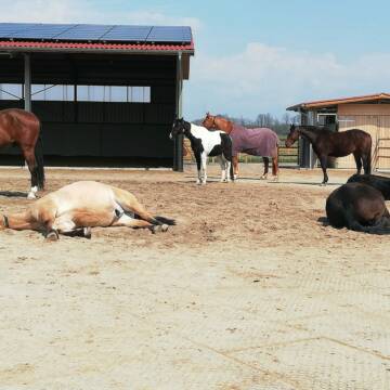
Hit-Aktivstall 2 Gruppen a' 25Tiere
Fernwald-Albach
Aktivstall-Thomas-Schaefer
@Aktivstall-Thomas-Schaefer
Freizeitstall
Krankenbox
Longierzirkel/Roundpen
Hufrehe geeignet
Bewegungsstall
Laufstall
12 weitere...
P

Pferdepension Mühlberghof
Asslar
Pferdepension-Muehlberghof
@Pferdepension-Muehlberghof
FN-Mitglied
Freizeitstall
Hunde willkommen
Krankenbox
Allergikerstall
bedampftes/gewaschenes Heu
Außenboxen
Laufstall
20 weitere...
P
Deprecated: Creation of dynamic property Zend_View_Helper_Ads::$adLink is deprecated in /var/www/stall-frei/htdocs/staging.stall-frei.de/library/Psf/View/Helper/Ads.php on line 108

Futtersack HeuToy, Fressbremse in pink
Mechtersen
STALL-FREIde Marketing
@STALL-FREI-Marketing
Stundenlange Beschäftigung die
Koliken vorbeugt, geringe Staubinhalation mit
steuerbarer Futterentnahme
Leider kein Vorschaubild
Leider kein Vorschaubild
Pferdebox frei
Pohlheim
Natalie Wohlfeil
@Natalie7
Vermieten
Reitplatz (z.B. Dressur, Springen, Reining)
Sattelkammer/Sattelschränke
Innenbox
Biofutter
Halbpension
4 weitere...
aktuell
B

Große, helle Pferdebox mit täglichem Weidegang
Buseck
Kyra Pohl
@kyra-schmetzer
Pferdeausbildung
Reitlehrer und -unterricht
Außenboxen
Vollpension
P
Leider kein Vorschaubild
Leider kein Vorschaubild
Reit- und Fahrverein Gleibergerland e.V.
Wettenberg
Lana Wolni
@NGB-Gleibergerland
Freizeitstall
Reitlehrer und -unterricht
Führanlage
Paddock
Außenbox mit Paddock
Außenboxen
Halbpension
Selbstversorgung
10 weitere...
B
Offenstallplätze und Hengstboxen für Islandpferd...
Ober-Mörlen
Thomas-Terhaar
@Thomas-Terhaar
Freizeitstall
Gangpferdereiten
Hunde willkommen
Krankenbox
Allergikerstall
Hengsthaltung möglich
Außenbox mit Paddock
Innenbox
18 weitere...
P

Heu aus neuer Ernte
Mechtersen
STALL-FREIde Marketing
@STALL-FREI-Marketing
Heulage und Pferdeheu aus der neuen Ernte findest du in unserem Futtermarkt
Leider kein Vorschaubild
Leider kein Vorschaubild
Pferdepesion Tannenhof-Weilmünster
Weilmünster
Tannenhof2020
@Tannenhof2020
Longierzirkel/Roundpen
Paddock
Außenbox mit Paddock
Innenbox
Vollpension
Einzelne Boxen oder Stallplätze
7 weitere...
B
bjquarterhorses + Zucht + Aufzucht + Pension
Leun-Biskirchen
BJ Quarterhorses
@BJ-Quarterhorses
FN-Mitglied
Freizeitstall
Vermieten
Verpachten
Hunde willkommen
Krankenbox
Allergikerstall
Gnadenbrothof
32 weitere...
P

Pferdesportzentrum Pfingsthof
Usingen
Reitanlage-Pfingsthof
@Reitanlage-Pfingsthof
FN-Mitglied
Pferdeausbildung
Vermieten
Führanlage
Hunde willkommen
bedampftes/gewaschenes Heu
Zuchtstutenhaltung möglich
21 weitere...
ganz aktuell
P

2HIT- Aktivställe, Aussen-+Paddockboxen, Wallache
Usingen
Oppelt u Manthey Oppelt GbR
@OppeltuMantheyOppeltGbR
FN-Mitglied
Freizeitstall
Hunde willkommen
Krankenbox
Hufrehe geeignet
Notfallboxen
Bewegungsstall
20 weitere...
P
Werde Teil von STALL-FREI.de
Du hast eine Pferdebox frei? Freie Plätze im Offenstall, Pferdestall oder der Reitanlage kostenlos anbieten.
Deprecated: Creation of dynamic property Zend_View::$pageCount is deprecated in /var/www/stall-frei/htdocs/staging.stall-frei.de/library/vendor/shardj/zf1-future/library/Zend/View/Abstract.php on line 308
Deprecated: Creation of dynamic property Zend_View::$itemCountPerPage is deprecated in /var/www/stall-frei/htdocs/staging.stall-frei.de/library/vendor/shardj/zf1-future/library/Zend/View/Abstract.php on line 308
Deprecated: Creation of dynamic property Zend_View::$first is deprecated in /var/www/stall-frei/htdocs/staging.stall-frei.de/library/vendor/shardj/zf1-future/library/Zend/View/Abstract.php on line 308
Deprecated: Creation of dynamic property Zend_View::$current is deprecated in /var/www/stall-frei/htdocs/staging.stall-frei.de/library/vendor/shardj/zf1-future/library/Zend/View/Abstract.php on line 308
Deprecated: Creation of dynamic property Zend_View::$last is deprecated in /var/www/stall-frei/htdocs/staging.stall-frei.de/library/vendor/shardj/zf1-future/library/Zend/View/Abstract.php on line 308
Deprecated: Creation of dynamic property Zend_View::$previous is deprecated in /var/www/stall-frei/htdocs/staging.stall-frei.de/library/vendor/shardj/zf1-future/library/Zend/View/Abstract.php on line 308
Deprecated: Creation of dynamic property Zend_View::$next is deprecated in /var/www/stall-frei/htdocs/staging.stall-frei.de/library/vendor/shardj/zf1-future/library/Zend/View/Abstract.php on line 308
Deprecated: Creation of dynamic property Zend_View::$pagesInRange is deprecated in /var/www/stall-frei/htdocs/staging.stall-frei.de/library/vendor/shardj/zf1-future/library/Zend/View/Abstract.php on line 308
Deprecated: Creation of dynamic property Zend_View::$firstPageInRange is deprecated in /var/www/stall-frei/htdocs/staging.stall-frei.de/library/vendor/shardj/zf1-future/library/Zend/View/Abstract.php on line 308
Deprecated: Creation of dynamic property Zend_View::$lastPageInRange is deprecated in /var/www/stall-frei/htdocs/staging.stall-frei.de/library/vendor/shardj/zf1-future/library/Zend/View/Abstract.php on line 308
Deprecated: Creation of dynamic property Zend_View::$currentItemCount is deprecated in /var/www/stall-frei/htdocs/staging.stall-frei.de/library/vendor/shardj/zf1-future/library/Zend/View/Abstract.php on line 308
Deprecated: Creation of dynamic property Zend_View::$totalItemCount is deprecated in /var/www/stall-frei/htdocs/staging.stall-frei.de/library/vendor/shardj/zf1-future/library/Zend/View/Abstract.php on line 308
Deprecated: Creation of dynamic property Zend_View::$firstItemNumber is deprecated in /var/www/stall-frei/htdocs/staging.stall-frei.de/library/vendor/shardj/zf1-future/library/Zend/View/Abstract.php on line 308
Deprecated: Creation of dynamic property Zend_View::$lastItemNumber is deprecated in /var/www/stall-frei/htdocs/staging.stall-frei.de/library/vendor/shardj/zf1-future/library/Zend/View/Abstract.php on line 308
Deprecated: Creation of dynamic property Zend_View::$router is deprecated in /var/www/stall-frei/htdocs/staging.stall-frei.de/library/vendor/shardj/zf1-future/library/Zend/View/Abstract.php on line 308
Deprecated: Creation of dynamic property Zend_View::$urlParams is deprecated in /var/www/stall-frei/htdocs/staging.stall-frei.de/library/vendor/shardj/zf1-future/library/Zend/View/Abstract.php on line 308
Deprecated: Creation of dynamic property Zend_View::$showAds is deprecated in /var/www/stall-frei/htdocs/staging.stall-frei.de/library/vendor/shardj/zf1-future/library/Zend/View/Abstract.php on line 308
Deprecated: Creation of dynamic property Zend_View::$objectIds is deprecated in /var/www/stall-frei/htdocs/staging.stall-frei.de/library/vendor/shardj/zf1-future/library/Zend/View/Abstract.php on line 308
Deprecated: Creation of dynamic property Zend_View::$showNavbar is deprecated in /var/www/stall-frei/htdocs/staging.stall-frei.de/library/vendor/shardj/zf1-future/library/Zend/View/Abstract.php on line 308
Deprecated: Creation of dynamic property Zend_View::$showBreadcrumb is deprecated in /var/www/stall-frei/htdocs/staging.stall-frei.de/library/vendor/shardj/zf1-future/library/Zend/View/Abstract.php on line 308
Deprecated: Creation of dynamic property Zend_View::$showFooter is deprecated in /var/www/stall-frei/htdocs/staging.stall-frei.de/library/vendor/shardj/zf1-future/library/Zend/View/Abstract.php on line 308
Deprecated: Creation of dynamic property Zend_View::$showInternalAds is deprecated in /var/www/stall-frei/htdocs/staging.stall-frei.de/library/vendor/shardj/zf1-future/library/Zend/View/Abstract.php on line 308
Deprecated: Creation of dynamic property Zend_View::$blNoContent is deprecated in /var/www/stall-frei/htdocs/staging.stall-frei.de/library/vendor/shardj/zf1-future/library/Zend/View/Abstract.php on line 308
Deprecated: Creation of dynamic property Zend_View::$sMetaDesc is deprecated in /var/www/stall-frei/htdocs/staging.stall-frei.de/library/vendor/shardj/zf1-future/library/Zend/View/Abstract.php on line 308
Deprecated: Creation of dynamic property Zend_View::$useGmaps is deprecated in /var/www/stall-frei/htdocs/staging.stall-frei.de/library/vendor/shardj/zf1-future/library/Zend/View/Abstract.php on line 308
Deprecated: Creation of dynamic property Zend_View::$touches is deprecated in /var/www/stall-frei/htdocs/staging.stall-frei.de/library/vendor/shardj/zf1-future/library/Zend/View/Abstract.php on line 308
Deprecated: Creation of dynamic property Zend_View::$oProject is deprecated in /var/www/stall-frei/htdocs/staging.stall-frei.de/library/vendor/shardj/zf1-future/library/Zend/View/Abstract.php on line 308
Deprecated: Creation of dynamic property Zend_View::$pageHeadline is deprecated in /var/www/stall-frei/htdocs/staging.stall-frei.de/library/vendor/shardj/zf1-future/library/Zend/View/Abstract.php on line 308
Deprecated: Creation of dynamic property Zend_View::$disableLocationField is deprecated in /var/www/stall-frei/htdocs/staging.stall-frei.de/library/vendor/shardj/zf1-future/library/Zend/View/Abstract.php on line 308
Deprecated: Creation of dynamic property Zend_View::$isSearch is deprecated in /var/www/stall-frei/htdocs/staging.stall-frei.de/library/vendor/shardj/zf1-future/library/Zend/View/Abstract.php on line 308
Deprecated: Creation of dynamic property Zend_View::$pageTitle is deprecated in /var/www/stall-frei/htdocs/staging.stall-frei.de/library/vendor/shardj/zf1-future/library/Zend/View/Abstract.php on line 308
Deprecated: Creation of dynamic property Psf_Form_Element_Text::$class is deprecated in /var/www/stall-frei/htdocs/staging.stall-frei.de/library/vendor/shardj/zf1-future/library/Zend/Form/Element.php on line 874
Deprecated: Creation of dynamic property Psf_Form_Element_Text::$size is deprecated in /var/www/stall-frei/htdocs/staging.stall-frei.de/library/vendor/shardj/zf1-future/library/Zend/Form/Element.php on line 874
Deprecated: Creation of dynamic property Psf_Form_Element_Text::$placeholder is deprecated in /var/www/stall-frei/htdocs/staging.stall-frei.de/library/vendor/shardj/zf1-future/library/Zend/Form/Element.php on line 874
Deprecated: Creation of dynamic property Psf_Form_Element_Hidden::$class is deprecated in /var/www/stall-frei/htdocs/staging.stall-frei.de/library/vendor/shardj/zf1-future/library/Zend/Form/Element.php on line 874
Deprecated: Creation of dynamic property Psf_Form_Element_Hidden::$class is deprecated in /var/www/stall-frei/htdocs/staging.stall-frei.de/library/vendor/shardj/zf1-future/library/Zend/Form/Element.php on line 874
Deprecated: Creation of dynamic property Psf_Form_Element_Hidden::$class is deprecated in /var/www/stall-frei/htdocs/staging.stall-frei.de/library/vendor/shardj/zf1-future/library/Zend/Form/Element.php on line 874
Deprecated: Creation of dynamic property Psf_Form_Element_Hidden::$class is deprecated in /var/www/stall-frei/htdocs/staging.stall-frei.de/library/vendor/shardj/zf1-future/library/Zend/Form/Element.php on line 874
Deprecated: Creation of dynamic property Psf_Form_Element_Select::$class is deprecated in /var/www/stall-frei/htdocs/staging.stall-frei.de/library/vendor/shardj/zf1-future/library/Zend/Form/Element.php on line 874
Deprecated: Creation of dynamic property Psf_Form_Element_Select::$class is deprecated in /var/www/stall-frei/htdocs/staging.stall-frei.de/library/vendor/shardj/zf1-future/library/Zend/Form/Element.php on line 874
Deprecated: Creation of dynamic property Psf_Form_Element_Select::$class is deprecated in /var/www/stall-frei/htdocs/staging.stall-frei.de/library/vendor/shardj/zf1-future/library/Zend/Form/Element.php on line 874
Deprecated: Creation of dynamic property Psf_Form_Element_Select::$class is deprecated in /var/www/stall-frei/htdocs/staging.stall-frei.de/library/vendor/shardj/zf1-future/library/Zend/Form/Element.php on line 874
Deprecated: Creation of dynamic property Psf_Form_Element_Text::$class is deprecated in /var/www/stall-frei/htdocs/staging.stall-frei.de/library/vendor/shardj/zf1-future/library/Zend/Form/Element.php on line 874
Deprecated: Creation of dynamic property Psf_Form_Element_Checkbox::$label is deprecated in /var/www/stall-frei/htdocs/staging.stall-frei.de/library/vendor/shardj/zf1-future/library/Zend/Form/Element.php on line 874
Deprecated: Creation of dynamic property Zend_View::$sort is deprecated in /var/www/stall-frei/htdocs/staging.stall-frei.de/library/vendor/shardj/zf1-future/library/Zend/View/Abstract.php on line 308
Deprecated: Creation of dynamic property Zend_View::$searchLocation is deprecated in /var/www/stall-frei/htdocs/staging.stall-frei.de/library/vendor/shardj/zf1-future/library/Zend/View/Abstract.php on line 308
Deprecated: Creation of dynamic property Zend_View::$locationHint is deprecated in /var/www/stall-frei/htdocs/staging.stall-frei.de/library/vendor/shardj/zf1-future/library/Zend/View/Abstract.php on line 308
Psf_GeoCoder_Abstract::getLocation: Hüttenberg Get Location CachedOrLive
Psf_GeoCoder_Abstract::getCachedOrLive: Hüttenberg
Psf_GeoCoder_OpenCageData::makeApiRequest: response:
Array
(
[documentation] => https://opencagedata.com/api
[licenses] => Array
(
[0] => Array
(
[name] => see attribution guide
[url] => https://opencagedata.com/credits
)
)
[results] => Array
(
[0] => Array
(
[bounds] => Array
(
[northeast] => Array
(
[lat] => 50.5366655
[lng] => 8.6513325
)
[southwest] => Array
(
[lat] => 50.4695807
[lng] => 8.4883287
)
)
[components] => Array
(
[ISO_3166-1_alpha-2] => DE
[ISO_3166-1_alpha-3] => DEU
[ISO_3166-2] => Array
(
[0] => DE-HE
)
[_category] => place
[_normalized_city] => Hüttenberg
[_type] => municipality
[continent] => Europe
[country] => Deutschland
[country_code] => de
[county] => Lahn-Dill-Kreis
[municipality] => Hüttenberg
[political_union] => European Union
[postcode] => 35625
[state] => Hessen
[state_code] => HE
)
[confidence] => 7
[formatted] => 35625 Hüttenberg, Deutschland
[geometry] => Array
(
[lat] => 50.51113
[lng] => 8.56487
)
)
[1] => Array
(
[bounds] => Array
(
[northeast] => Array
(
[lat] => 51.4044566
[lng] => 8.7956919
)
[southwest] => Array
(
[lat] => 51.3946903
[lng] => 8.7824582
)
)
[components] => Array
(
[ISO_3166-1_alpha-2] => DE
[ISO_3166-1_alpha-3] => DEU
[ISO_3166-2] => Array
(
[0] => DE-NW
)
[_category] => natural/water
[_normalized_city] => Marsberg
[_type] => nature_reserve
[continent] => Europe
[country] => Deutschland
[country_code] => de
[county] => Hochsauerlandkreis
[nature_reserve] => Hüttenberg
[political_union] => European Union
[postcode] => 34431
[state] => Nordrhein-Westfalen
[state_code] => NW
[suburb] => Giershagen
[town] => Marsberg
)
[confidence] => 8
[formatted] => Hüttenberg, 34431 Marsberg, Deutschland
[geometry] => Array
(
[lat] => 51.3995378
[lng] => 8.787282
)
)
[2] => Array
(
[bounds] => Array
(
[northeast] => Array
(
[lat] => 49.3625196
[lng] => 7.6323993
)
[southwest] => Array
(
[lat] => 49.3624196
[lng] => 7.6322993
)
)
[components] => Array
(
[ISO_3166-1_alpha-2] => DE
[ISO_3166-1_alpha-3] => DEU
[ISO_3166-2] => Array
(
[0] => DE-RP
)
[_category] => natural/water
[_normalized_city] => Queidersbach
[_type] => peak
[continent] => Europe
[country] => Deutschland
[country_code] => de
[county] => Landkreis Kaiserslautern
[municipality] => Landstuhl
[peak] => Hüttenberg
[political_union] => European Union
[postcode] => 67706
[state] => Rheinland-Pfalz
[state_code] => RP
[village] => Queidersbach
)
[confidence] => 9
[formatted] => Hüttenberg, 67706 Queidersbach, Deutschland
[geometry] => Array
(
[lat] => 49.3624696
[lng] => 7.6323493
)
)
[3] => Array
(
[bounds] => Array
(
[northeast] => Array
(
[lat] => 50.9800548
[lng] => 8.1533303
)
[southwest] => Array
(
[lat] => 50.9799548
[lng] => 8.1532303
)
)
[components] => Array
(
[ISO_3166-1_alpha-2] => DE
[ISO_3166-1_alpha-3] => DEU
[ISO_3166-2] => Array
(
[0] => DE-NW
)
[_category] => natural/water
[_normalized_city] => Hilchenbach
[_type] => peak
[continent] => Europe
[country] => Deutschland
[country_code] => de
[county] => Kreis Siegen-Wittgenstein
[peak] => Hüttenberg
[political_union] => European Union
[state] => Nordrhein-Westfalen
[state_code] => NW
[town] => Hilchenbach
)
[confidence] => 9
[formatted] => Hüttenberg, Hilchenbach, Nordrhein-Westfalen, Deutschland
[geometry] => Array
(
[lat] => 50.9800048
[lng] => 8.1532803
)
)
[4] => Array
(
[bounds] => Array
(
[northeast] => Array
(
[lat] => 51.2088649
[lng] => 8.9607036
)
[southwest] => Array
(
[lat] => 51.2087649
[lng] => 8.9606036
)
)
[components] => Array
(
[ISO_3166-1_alpha-2] => DE
[ISO_3166-1_alpha-3] => DEU
[ISO_3166-2] => Array
(
[0] => DE-HE
)
[_category] => natural/water
[_normalized_city] => Vöhl
[_type] => peak
[continent] => Europe
[country] => Deutschland
[country_code] => de
[county] => Landkreis Waldeck-Frankenberg
[municipality] => Vöhl
[peak] => Hüttenberg
[political_union] => European Union
[postcode] => 34516
[state] => Hessen
[state_code] => HE
[village] => Vöhl
)
[confidence] => 9
[formatted] => Hüttenberg, 34516 Vöhl, Deutschland
[geometry] => Array
(
[lat] => 51.2088149
[lng] => 8.9606536
)
)
[5] => Array
(
[bounds] => Array
(
[northeast] => Array
(
[lat] => 49.7892694
[lng] => 7.6534871
)
[southwest] => Array
(
[lat] => 49.7891694
[lng] => 7.6533871
)
)
[components] => Array
(
[ISO_3166-1_alpha-2] => DE
[ISO_3166-1_alpha-3] => DEU
[ISO_3166-2] => Array
(
[0] => DE-RP
)
[_category] => natural/water
[_normalized_city] => Bad Sobernheim
[_type] => peak
[continent] => Europe
[country] => Deutschland
[country_code] => de
[county] => Landkreis Bad Kreuznach
[municipality] => Nahe-Glan
[peak] => Hüttenberg
[political_union] => European Union
[postcode] => 55566
[state] => Rheinland-Pfalz
[state_code] => RP
[town] => Bad Sobernheim
)
[confidence] => 9
[formatted] => Hüttenberg, 55566 Bad Sobernheim, Deutschland
[geometry] => Array
(
[lat] => 49.7892194
[lng] => 7.6534371
)
)
[6] => Array
(
[bounds] => Array
(
[northeast] => Array
(
[lat] => 51.0601545
[lng] => 7.6795853
)
[southwest] => Array
(
[lat] => 51.0600545
[lng] => 7.6794853
)
)
[components] => Array
(
[ISO_3166-1_alpha-2] => DE
[ISO_3166-1_alpha-3] => DEU
[ISO_3166-2] => Array
(
[0] => DE-NW
)
[_category] => natural/water
[_normalized_city] => Gummersbach
[_type] => peak
[continent] => Europe
[country] => Deutschland
[country_code] => de
[county] => Oberbergischer Kreis
[peak] => Hüttenberg
[political_union] => European Union
[postcode] => 51702
[state] => Nordrhein-Westfalen
[state_code] => NW
[town] => Gummersbach
)
[confidence] => 9
[formatted] => Hüttenberg, 51702 Gummersbach, Deutschland
[geometry] => Array
(
[lat] => 51.0601045
[lng] => 7.6795353
)
)
[7] => Array
(
[bounds] => Array
(
[northeast] => Array
(
[lat] => 52.0872457
[lng] => 9.0456973
)
[southwest] => Array
(
[lat] => 52.0871457
[lng] => 9.0455973
)
)
[components] => Array
(
[ISO_3166-1_alpha-2] => DE
[ISO_3166-1_alpha-3] => DEU
[ISO_3166-2] => Array
(
[0] => DE-NW
)
[_category] => natural/water
[_normalized_city] => Extertal
[_type] => peak
[continent] => Europe
[country] => Deutschland
[country_code] => de
[county] => Kreis Lippe
[peak] => Hüttenberg
[political_union] => European Union
[state] => Nordrhein-Westfalen
[state_code] => NW
[village] => Extertal
)
[confidence] => 9
[formatted] => Hüttenberg, Extertal, Nordrhein-Westfalen, Deutschland
[geometry] => Array
(
[lat] => 52.0871957
[lng] => 9.0456473
)
)
[8] => Array
(
[bounds] => Array
(
[northeast] => Array
(
[lat] => 51.171744
[lng] => 7.5782494
)
[southwest] => Array
(
[lat] => 51.171644
[lng] => 7.5781494
)
)
[components] => Array
(
[ISO_3166-1_alpha-2] => DE
[ISO_3166-1_alpha-3] => DEU
[ISO_3166-2] => Array
(
[0] => DE-NW
)
[_category] => natural/water
[_normalized_city] => Kierspe
[_type] => peak
[continent] => Europe
[country] => Deutschland
[country_code] => de
[county] => Märkischer Kreis
[peak] => Hüttenberg
[political_union] => European Union
[postcode] => 58566
[state] => Nordrhein-Westfalen
[state_code] => NW
[town] => Kierspe
)
[confidence] => 9
[formatted] => Hüttenberg, 58566 Kierspe, Deutschland
[geometry] => Array
(
[lat] => 51.171694
[lng] => 7.5781994
)
)
[9] => Array
(
[bounds] => Array
(
[northeast] => Array
(
[lat] => 49.6536175
[lng] => 9.2505351
)
[southwest] => Array
(
[lat] => 49.6535175
[lng] => 9.2504351
)
)
[components] => Array
(
[ISO_3166-1_alpha-2] => DE
[ISO_3166-1_alpha-3] => DEU
[ISO_3166-2] => Array
(
[0] => DE-BY
)
[_category] => natural/water
[_normalized_city] => Amorbach
[_type] => peak
[continent] => Europe
[country] => Deutschland
[country_code] => de
[county] => Landkreis Miltenberg
[peak] => Hüttenberg
[political_union] => European Union
[postcode] => 63936
[state] => Bayern
[state_code] => BY
[town] => Amorbach
)
[confidence] => 9
[formatted] => Hüttenberg, 63936 Amorbach, Deutschland
[geometry] => Array
(
[lat] => 49.6535675
[lng] => 9.2504851
)
)
)
[status] => Array
(
[code] => 200
[message] => OK
)
[stay_informed] => Array
(
[blog] => https://blog.opencagedata.com
[mastodon] => https://en.osm.town/@opencage
)
[thanks] => For using an OpenCage API
[timestamp] => Array
(
[created_http] => Fri, 06 Feb 2026 07:59:21 GMT
[created_unix] => 1770364761
)
[total_results] => 10
)
Psf_GeoCoder_Abstract::convertLocationResult
{"documentation":"https:\/\/opencagedata.com\/api","licenses":[{"name":"see attribution guide","url":"https:\/\/opencagedata.com\/credits"}],"results":[{"bounds":{"northeast":{"lat":50.5366655,"lng":8.6513325},"southwest":{"lat":50.4695807,"lng":8.4883287}},"components":{"ISO_3166-1_alpha-2":"DE","ISO_3166-1_alpha-3":"DEU","ISO_3166-2":["DE-HE"],"_category":"place","_normalized_city":"H\u00fcttenberg","_type":"municipality","continent":"Europe","country":"Deutschland","country_code":"de","county":"Lahn-Dill-Kreis","municipality":"H\u00fcttenberg","political_union":"European Union","postcode":"35625","state":"Hessen","state_code":"HE"},"confidence":7,"formatted":"35625 H\u00fcttenberg, Deutschland","geometry":{"lat":50.51113,"lng":8.56487}},{"bounds":{"northeast":{"lat":51.4044566,"lng":8.7956919},"southwest":{"lat":51.3946903,"lng":8.7824582}},"components":{"ISO_3166-1_alpha-2":"DE","ISO_3166-1_alpha-3":"DEU","ISO_3166-2":["DE-NW"],"_category":"natural\/water","_normalized_city":"Marsberg","_type":"nature_reserve","continent":"Europe","country":"Deutschland","country_code":"de","county":"Hochsauerlandkreis","nature_reserve":"H\u00fcttenberg","political_union":"European Union","postcode":"34431","state":"Nordrhein-Westfalen","state_code":"NW","suburb":"Giershagen","town":"Marsberg"},"confidence":8,"formatted":"H\u00fcttenberg, 34431 Marsberg, Deutschland","geometry":{"lat":51.3995378,"lng":8.787282}},{"bounds":{"northeast":{"lat":49.3625196,"lng":7.6323993},"southwest":{"lat":49.3624196,"lng":7.6322993}},"components":{"ISO_3166-1_alpha-2":"DE","ISO_3166-1_alpha-3":"DEU","ISO_3166-2":["DE-RP"],"_category":"natural\/water","_normalized_city":"Queidersbach","_type":"peak","continent":"Europe","country":"Deutschland","country_code":"de","county":"Landkreis Kaiserslautern","municipality":"Landstuhl","peak":"H\u00fcttenberg","political_union":"European Union","postcode":"67706","state":"Rheinland-Pfalz","state_code":"RP","village":"Queidersbach"},"confidence":9,"formatted":"H\u00fcttenberg, 67706 Queidersbach, Deutschland","geometry":{"lat":49.3624696,"lng":7.6323493}},{"bounds":{"northeast":{"lat":50.9800548,"lng":8.1533303},"southwest":{"lat":50.9799548,"lng":8.1532303}},"components":{"ISO_3166-1_alpha-2":"DE","ISO_3166-1_alpha-3":"DEU","ISO_3166-2":["DE-NW"],"_category":"natural\/water","_normalized_city":"Hilchenbach","_type":"peak","continent":"Europe","country":"Deutschland","country_code":"de","county":"Kreis Siegen-Wittgenstein","peak":"H\u00fcttenberg","political_union":"European Union","state":"Nordrhein-Westfalen","state_code":"NW","town":"Hilchenbach"},"confidence":9,"formatted":"H\u00fcttenberg, Hilchenbach, Nordrhein-Westfalen, Deutschland","geometry":{"lat":50.9800048,"lng":8.1532803}},{"bounds":{"northeast":{"lat":51.2088649,"lng":8.9607036},"southwest":{"lat":51.2087649,"lng":8.9606036}},"components":{"ISO_3166-1_alpha-2":"DE","ISO_3166-1_alpha-3":"DEU","ISO_3166-2":["DE-HE"],"_category":"natural\/water","_normalized_city":"V\u00f6hl","_type":"peak","continent":"Europe","country":"Deutschland","country_code":"de","county":"Landkreis Waldeck-Frankenberg","municipality":"V\u00f6hl","peak":"H\u00fcttenberg","political_union":"European Union","postcode":"34516","state":"Hessen","state_code":"HE","village":"V\u00f6hl"},"confidence":9,"formatted":"H\u00fcttenberg, 34516 V\u00f6hl, Deutschland","geometry":{"lat":51.2088149,"lng":8.9606536}},{"bounds":{"northeast":{"lat":49.7892694,"lng":7.6534871},"southwest":{"lat":49.7891694,"lng":7.6533871}},"components":{"ISO_3166-1_alpha-2":"DE","ISO_3166-1_alpha-3":"DEU","ISO_3166-2":["DE-RP"],"_category":"natural\/water","_normalized_city":"Bad Sobernheim","_type":"peak","continent":"Europe","country":"Deutschland","country_code":"de","county":"Landkreis Bad Kreuznach","municipality":"Nahe-Glan","peak":"H\u00fcttenberg","political_union":"European Union","postcode":"55566","state":"Rheinland-Pfalz","state_code":"RP","town":"Bad Sobernheim"},"confidence":9,"formatted":"H\u00fcttenberg, 55566 Bad Sobernheim, Deutschland","geometry":{"lat":49.7892194,"lng":7.6534371}},{"bounds":{"northeast":{"lat":51.0601545,"lng":7.6795853},"southwest":{"lat":51.0600545,"lng":7.6794853}},"components":{"ISO_3166-1_alpha-2":"DE","ISO_3166-1_alpha-3":"DEU","ISO_3166-2":["DE-NW"],"_category":"natural\/water","_normalized_city":"Gummersbach","_type":"peak","continent":"Europe","country":"Deutschland","country_code":"de","county":"Oberbergischer Kreis","peak":"H\u00fcttenberg","political_union":"European Union","postcode":"51702","state":"Nordrhein-Westfalen","state_code":"NW","town":"Gummersbach"},"confidence":9,"formatted":"H\u00fcttenberg, 51702 Gummersbach, Deutschland","geometry":{"lat":51.0601045,"lng":7.6795353}},{"bounds":{"northeast":{"lat":52.0872457,"lng":9.0456973},"southwest":{"lat":52.0871457,"lng":9.0455973}},"components":{"ISO_3166-1_alpha-2":"DE","ISO_3166-1_alpha-3":"DEU","ISO_3166-2":["DE-NW"],"_category":"natural\/water","_normalized_city":"Extertal","_type":"peak","continent":"Europe","country":"Deutschland","country_code":"de","county":"Kreis Lippe","peak":"H\u00fcttenberg","political_union":"European Union","state":"Nordrhein-Westfalen","state_code":"NW","village":"Extertal"},"confidence":9,"formatted":"H\u00fcttenberg, Extertal, Nordrhein-Westfalen, Deutschland","geometry":{"lat":52.0871957,"lng":9.0456473}},{"bounds":{"northeast":{"lat":51.171744,"lng":7.5782494},"southwest":{"lat":51.171644,"lng":7.5781494}},"components":{"ISO_3166-1_alpha-2":"DE","ISO_3166-1_alpha-3":"DEU","ISO_3166-2":["DE-NW"],"_category":"natural\/water","_normalized_city":"Kierspe","_type":"peak","continent":"Europe","country":"Deutschland","country_code":"de","county":"M\u00e4rkischer Kreis","peak":"H\u00fcttenberg","political_union":"European Union","postcode":"58566","state":"Nordrhein-Westfalen","state_code":"NW","town":"Kierspe"},"confidence":9,"formatted":"H\u00fcttenberg, 58566 Kierspe, Deutschland","geometry":{"lat":51.171694,"lng":7.5781994}},{"bounds":{"northeast":{"lat":49.6536175,"lng":9.2505351},"southwest":{"lat":49.6535175,"lng":9.2504351}},"components":{"ISO_3166-1_alpha-2":"DE","ISO_3166-1_alpha-3":"DEU","ISO_3166-2":["DE-BY"],"_category":"natural\/water","_normalized_city":"Amorbach","_type":"peak","continent":"Europe","country":"Deutschland","country_code":"de","county":"Landkreis Miltenberg","peak":"H\u00fcttenberg","political_union":"European Union","postcode":"63936","state":"Bayern","state_code":"BY","town":"Amorbach"},"confidence":9,"formatted":"H\u00fcttenberg, 63936 Amorbach, Deutschland","geometry":{"lat":49.6535675,"lng":9.2504851}}],"status":{"code":200,"message":"OK"},"stay_informed":{"blog":"https:\/\/blog.opencagedata.com","mastodon":"https:\/\/en.osm.town\/@opencage"},"thanks":"For using an OpenCage API","timestamp":{"created_http":"Fri, 06 Feb 2026 07:59:21 GMT","created_unix":1770364761},"total_results":10}Array
(
[0] => stdClass Object
(
[bounds] => stdClass Object
(
[northeast] => stdClass Object
(
[lat] => 50.5366655
[lng] => 8.6513325
)
[southwest] => stdClass Object
(
[lat] => 50.4695807
[lng] => 8.4883287
)
)
[components] => stdClass Object
(
[ISO_3166-1_alpha-2] => DE
[ISO_3166-1_alpha-3] => DEU
[ISO_3166-2] => Array
(
[0] => DE-HE
)
[_category] => place
[_normalized_city] => Hüttenberg
[_type] => municipality
[continent] => Europe
[country] => Deutschland
[country_code] => de
[county] => Lahn-Dill-Kreis
[municipality] => Hüttenberg
[political_union] => European Union
[postcode] => 35625
[state] => Hessen
[state_code] => HE
)
[confidence] => 7
[formatted] => 35625 Hüttenberg, Deutschland
[geometry] => stdClass Object
(
[lat] => 50.51113
[lng] => 8.56487
)
)
[1] => stdClass Object
(
[bounds] => stdClass Object
(
[northeast] => stdClass Object
(
[lat] => 51.4044566
[lng] => 8.7956919
)
[southwest] => stdClass Object
(
[lat] => 51.3946903
[lng] => 8.7824582
)
)
[components] => stdClass Object
(
[ISO_3166-1_alpha-2] => DE
[ISO_3166-1_alpha-3] => DEU
[ISO_3166-2] => Array
(
[0] => DE-NW
)
[_category] => natural/water
[_normalized_city] => Marsberg
[_type] => nature_reserve
[continent] => Europe
[country] => Deutschland
[country_code] => de
[county] => Hochsauerlandkreis
[nature_reserve] => Hüttenberg
[political_union] => European Union
[postcode] => 34431
[state] => Nordrhein-Westfalen
[state_code] => NW
[suburb] => Giershagen
[town] => Marsberg
)
[confidence] => 8
[formatted] => Hüttenberg, 34431 Marsberg, Deutschland
[geometry] => stdClass Object
(
[lat] => 51.3995378
[lng] => 8.787282
)
)
[2] => stdClass Object
(
[bounds] => stdClass Object
(
[northeast] => stdClass Object
(
[lat] => 49.3625196
[lng] => 7.6323993
)
[southwest] => stdClass Object
(
[lat] => 49.3624196
[lng] => 7.6322993
)
)
[components] => stdClass Object
(
[ISO_3166-1_alpha-2] => DE
[ISO_3166-1_alpha-3] => DEU
[ISO_3166-2] => Array
(
[0] => DE-RP
)
[_category] => natural/water
[_normalized_city] => Queidersbach
[_type] => peak
[continent] => Europe
[country] => Deutschland
[country_code] => de
[county] => Landkreis Kaiserslautern
[municipality] => Landstuhl
[peak] => Hüttenberg
[political_union] => European Union
[postcode] => 67706
[state] => Rheinland-Pfalz
[state_code] => RP
[village] => Queidersbach
)
[confidence] => 9
[formatted] => Hüttenberg, 67706 Queidersbach, Deutschland
[geometry] => stdClass Object
(
[lat] => 49.3624696
[lng] => 7.6323493
)
)
[3] => stdClass Object
(
[bounds] => stdClass Object
(
[northeast] => stdClass Object
(
[lat] => 50.9800548
[lng] => 8.1533303
)
[southwest] => stdClass Object
(
[lat] => 50.9799548
[lng] => 8.1532303
)
)
[components] => stdClass Object
(
[ISO_3166-1_alpha-2] => DE
[ISO_3166-1_alpha-3] => DEU
[ISO_3166-2] => Array
(
[0] => DE-NW
)
[_category] => natural/water
[_normalized_city] => Hilchenbach
[_type] => peak
[continent] => Europe
[country] => Deutschland
[country_code] => de
[county] => Kreis Siegen-Wittgenstein
[peak] => Hüttenberg
[political_union] => European Union
[state] => Nordrhein-Westfalen
[state_code] => NW
[town] => Hilchenbach
)
[confidence] => 9
[formatted] => Hüttenberg, Hilchenbach, Nordrhein-Westfalen, Deutschland
[geometry] => stdClass Object
(
[lat] => 50.9800048
[lng] => 8.1532803
)
)
[4] => stdClass Object
(
[bounds] => stdClass Object
(
[northeast] => stdClass Object
(
[lat] => 51.2088649
[lng] => 8.9607036
)
[southwest] => stdClass Object
(
[lat] => 51.2087649
[lng] => 8.9606036
)
)
[components] => stdClass Object
(
[ISO_3166-1_alpha-2] => DE
[ISO_3166-1_alpha-3] => DEU
[ISO_3166-2] => Array
(
[0] => DE-HE
)
[_category] => natural/water
[_normalized_city] => Vöhl
[_type] => peak
[continent] => Europe
[country] => Deutschland
[country_code] => de
[county] => Landkreis Waldeck-Frankenberg
[municipality] => Vöhl
[peak] => Hüttenberg
[political_union] => European Union
[postcode] => 34516
[state] => Hessen
[state_code] => HE
[village] => Vöhl
)
[confidence] => 9
[formatted] => Hüttenberg, 34516 Vöhl, Deutschland
[geometry] => stdClass Object
(
[lat] => 51.2088149
[lng] => 8.9606536
)
)
[5] => stdClass Object
(
[bounds] => stdClass Object
(
[northeast] => stdClass Object
(
[lat] => 49.7892694
[lng] => 7.6534871
)
[southwest] => stdClass Object
(
[lat] => 49.7891694
[lng] => 7.6533871
)
)
[components] => stdClass Object
(
[ISO_3166-1_alpha-2] => DE
[ISO_3166-1_alpha-3] => DEU
[ISO_3166-2] => Array
(
[0] => DE-RP
)
[_category] => natural/water
[_normalized_city] => Bad Sobernheim
[_type] => peak
[continent] => Europe
[country] => Deutschland
[country_code] => de
[county] => Landkreis Bad Kreuznach
[municipality] => Nahe-Glan
[peak] => Hüttenberg
[political_union] => European Union
[postcode] => 55566
[state] => Rheinland-Pfalz
[state_code] => RP
[town] => Bad Sobernheim
)
[confidence] => 9
[formatted] => Hüttenberg, 55566 Bad Sobernheim, Deutschland
[geometry] => stdClass Object
(
[lat] => 49.7892194
[lng] => 7.6534371
)
)
[6] => stdClass Object
(
[bounds] => stdClass Object
(
[northeast] => stdClass Object
(
[lat] => 51.0601545
[lng] => 7.6795853
)
[southwest] => stdClass Object
(
[lat] => 51.0600545
[lng] => 7.6794853
)
)
[components] => stdClass Object
(
[ISO_3166-1_alpha-2] => DE
[ISO_3166-1_alpha-3] => DEU
[ISO_3166-2] => Array
(
[0] => DE-NW
)
[_category] => natural/water
[_normalized_city] => Gummersbach
[_type] => peak
[continent] => Europe
[country] => Deutschland
[country_code] => de
[county] => Oberbergischer Kreis
[peak] => Hüttenberg
[political_union] => European Union
[postcode] => 51702
[state] => Nordrhein-Westfalen
[state_code] => NW
[town] => Gummersbach
)
[confidence] => 9
[formatted] => Hüttenberg, 51702 Gummersbach, Deutschland
[geometry] => stdClass Object
(
[lat] => 51.0601045
[lng] => 7.6795353
)
)
[7] => stdClass Object
(
[bounds] => stdClass Object
(
[northeast] => stdClass Object
(
[lat] => 52.0872457
[lng] => 9.0456973
)
[southwest] => stdClass Object
(
[lat] => 52.0871457
[lng] => 9.0455973
)
)
[components] => stdClass Object
(
[ISO_3166-1_alpha-2] => DE
[ISO_3166-1_alpha-3] => DEU
[ISO_3166-2] => Array
(
[0] => DE-NW
)
[_category] => natural/water
[_normalized_city] => Extertal
[_type] => peak
[continent] => Europe
[country] => Deutschland
[country_code] => de
[county] => Kreis Lippe
[peak] => Hüttenberg
[political_union] => European Union
[state] => Nordrhein-Westfalen
[state_code] => NW
[village] => Extertal
)
[confidence] => 9
[formatted] => Hüttenberg, Extertal, Nordrhein-Westfalen, Deutschland
[geometry] => stdClass Object
(
[lat] => 52.0871957
[lng] => 9.0456473
)
)
[8] => stdClass Object
(
[bounds] => stdClass Object
(
[northeast] => stdClass Object
(
[lat] => 51.171744
[lng] => 7.5782494
)
[southwest] => stdClass Object
(
[lat] => 51.171644
[lng] => 7.5781494
)
)
[components] => stdClass Object
(
[ISO_3166-1_alpha-2] => DE
[ISO_3166-1_alpha-3] => DEU
[ISO_3166-2] => Array
(
[0] => DE-NW
)
[_category] => natural/water
[_normalized_city] => Kierspe
[_type] => peak
[continent] => Europe
[country] => Deutschland
[country_code] => de
[county] => Märkischer Kreis
[peak] => Hüttenberg
[political_union] => European Union
[postcode] => 58566
[state] => Nordrhein-Westfalen
[state_code] => NW
[town] => Kierspe
)
[confidence] => 9
[formatted] => Hüttenberg, 58566 Kierspe, Deutschland
[geometry] => stdClass Object
(
[lat] => 51.171694
[lng] => 7.5781994
)
)
[9] => stdClass Object
(
[bounds] => stdClass Object
(
[northeast] => stdClass Object
(
[lat] => 49.6536175
[lng] => 9.2505351
)
[southwest] => stdClass Object
(
[lat] => 49.6535175
[lng] => 9.2504351
)
)
[components] => stdClass Object
(
[ISO_3166-1_alpha-2] => DE
[ISO_3166-1_alpha-3] => DEU
[ISO_3166-2] => Array
(
[0] => DE-BY
)
[_category] => natural/water
[_normalized_city] => Amorbach
[_type] => peak
[continent] => Europe
[country] => Deutschland
[country_code] => de
[county] => Landkreis Miltenberg
[peak] => Hüttenberg
[political_union] => European Union
[postcode] => 63936
[state] => Bayern
[state_code] => BY
[town] => Amorbach
)
[confidence] => 9
[formatted] => Hüttenberg, 63936 Amorbach, Deutschland
[geometry] => stdClass Object
(
[lat] => 49.6535675
[lng] => 9.2504851
)
)
)
Psf_GeoCoder_OpenCageData::getKeyMap: 0
stdClass Object
(
    [bounds] => stdClass Object
        (
            [northeast] => stdClass Object
                (
                    [lat] => 50.5366655
                    [lng] => 8.6513325
                )

            [southwest] => stdClass Object
                (
                    [lat] => 50.4695807
                    [lng] => 8.4883287
                )

        )

    [components] => stdClass Object
        (
            [ISO_3166-1_alpha-2] => DE
            [ISO_3166-1_alpha-3] => DEU
            [ISO_3166-2] => Array
                (
                    [0] => DE-HE
                )

            [_category] => place
            [_normalized_city] => Hüttenberg
            [_type] => municipality
            [continent] => Europe
            [country] => Deutschland
            [country_code] => de
            [county] => Lahn-Dill-Kreis
            [municipality] => Hüttenberg
            [political_union] => European Union
            [postcode] => 35625
            [state] => Hessen
            [state_code] => HE
        )

    [confidence] => 7
    [formatted] => 35625 Hüttenberg, Deutschland
    [geometry] => stdClass Object
        (
            [lat] => 50.51113
            [lng] => 8.56487
        )

)
Psf_GeoCoder_OpenCageData::getCounty: Lahn-Dill-Kreis
Psf_GeoCoder_OpenCageData::addMissingData REFETCH!
Array
(
    [address] => 35625 Hüttenberg, Deutschland
    [type] => municipality
    [street] =>
    [city] =>
    [county] => Lahn-Dill-Kreis
    [state] => Hessen
    [zip] => 35625
    [country] => Deutschland
    [suburb] =>
    [countrycode] => de
    [latitude] => 50.51113
    [longitude] => 8.56487
    [accuracy] => 1
    [confidence] => 7
    [bounds] => stdClass Object
        (
            [northeast] => stdClass Object
                (
                    [lat] => 50.5366655
                    [lng] => 8.6513325
                )

            [southwest] => stdClass Object
                (
                    [lat] => 50.4695807
                    [lng] => 8.4883287
                )

        )

)
reformat!
Array
(
    [address] => 35625 Hüttenberg, Deutschland
    [type] => municipality
    [street] =>
    [city] =>
    [county] => Lahn-Dill-Kreis
    [state] => Hessen
    [zip] => 35625
    [country] => Deutschland
    [suburb] =>
    [countrycode] => de
    [latitude] => 50.51113
    [longitude] => 8.56487
    [accuracy] => 1
    [confidence] => 7
    [bounds] => stdClass Object
        (
            [northeast] => stdClass Object
                (
                    [lat] => 50.5366655
                    [lng] => 8.6513325
                )

            [southwest] => stdClass Object
                (
                    [lat] => 50.4695807
                    [lng] => 8.4883287
                )

        )

    [place] => 35625 , Hessen
    [hash] => ac7d1545b8e99fea645a4729b0430b33
)
Psf_GeoCoder_OpenCageData::getKeyMap: 1
stdClass Object
(
    [bounds] => stdClass Object
        (
            [northeast] => stdClass Object
                (
                    [lat] => 51.4044566
                    [lng] => 8.7956919
                )

            [southwest] => stdClass Object
                (
                    [lat] => 51.3946903
                    [lng] => 8.7824582
                )

        )

    [components] => stdClass Object
        (
            [ISO_3166-1_alpha-2] => DE
            [ISO_3166-1_alpha-3] => DEU
            [ISO_3166-2] => Array
                (
                    [0] => DE-NW
                )

            [_category] => natural/water
            [_normalized_city] => Marsberg
            [_type] => nature_reserve
            [continent] => Europe
            [country] => Deutschland
            [country_code] => de
            [county] => Hochsauerlandkreis
            [nature_reserve] => Hüttenberg
            [political_union] => European Union
            [postcode] => 34431
            [state] => Nordrhein-Westfalen
            [state_code] => NW
            [suburb] => Giershagen
            [town] => Marsberg
        )

    [confidence] => 8
    [formatted] => Hüttenberg, 34431 Marsberg, Deutschland
    [geometry] => stdClass Object
        (
            [lat] => 51.3995378
            [lng] => 8.787282
        )

)
Psf_GeoCoder_OpenCageData::getCounty: Hochsauerlandkreis
Psf_GeoCoder_OpenCageData::addMissingData REFETCH!
Array
(
    [address] => Hüttenberg, 34431 Marsberg, Deutschland
    [type] => nature_reserve
    [street] =>
    [city] => Marsberg
    [county] => Hochsauerlandkreis
    [state] => Nordrhein-Westfalen
    [zip] => 34431
    [country] => Deutschland
    [suburb] => Giershagen
    [countrycode] => de
    [latitude] => 51.3995378
    [longitude] => 8.787282
    [accuracy] => 1
    [confidence] => 8
    [bounds] => stdClass Object
        (
            [northeast] => stdClass Object
                (
                    [lat] => 51.4044566
                    [lng] => 8.7956919
                )

            [southwest] => stdClass Object
                (
                    [lat] => 51.3946903
                    [lng] => 8.7824582
                )

        )

)
reformat!
Array
(
    [address] => Hüttenberg, 34431 Marsberg, Deutschland
    [type] => nature_reserve
    [street] =>
    [city] => Marsberg
    [county] => Hochsauerlandkreis
    [state] => Nordrhein-Westfalen
    [zip] => 34431
    [country] => Deutschland
    [suburb] => Giershagen
    [countrycode] => de
    [latitude] => 51.3995378
    [longitude] => 8.787282
    [accuracy] => 1
    [confidence] => 8
    [bounds] => stdClass Object
        (
            [northeast] => stdClass Object
                (
                    [lat] => 51.4044566
                    [lng] => 8.7956919
                )

            [southwest] => stdClass Object
                (
                    [lat] => 51.3946903
                    [lng] => 8.7824582
                )

        )

    [place] => 34431 Marsberg, Nordrhein-Westfalen
    [hash] => 5c2b1e792e3ac8fa9bf099cf6380a831
)
Psf_GeoCoder_OpenCageData::getKeyMap: 2
stdClass Object
(
    [bounds] => stdClass Object
        (
            [northeast] => stdClass Object
                (
                    [lat] => 49.3625196
                    [lng] => 7.6323993
                )

            [southwest] => stdClass Object
                (
                    [lat] => 49.3624196
                    [lng] => 7.6322993
                )

        )

    [components] => stdClass Object
        (
            [ISO_3166-1_alpha-2] => DE
            [ISO_3166-1_alpha-3] => DEU
            [ISO_3166-2] => Array
                (
                    [0] => DE-RP
                )

            [_category] => natural/water
            [_normalized_city] => Queidersbach
            [_type] => peak
            [continent] => Europe
            [country] => Deutschland
            [country_code] => de
            [county] => Landkreis Kaiserslautern
            [municipality] => Landstuhl
            [peak] => Hüttenberg
            [political_union] => European Union
            [postcode] => 67706
            [state] => Rheinland-Pfalz
            [state_code] => RP
            [village] => Queidersbach
        )

    [confidence] => 9
    [formatted] => Hüttenberg, 67706 Queidersbach, Deutschland
    [geometry] => stdClass Object
        (
            [lat] => 49.3624696
            [lng] => 7.6323493
        )

)
Psf_GeoCoder_OpenCageData::getCounty: Kaiserslautern
Psf_GeoCoder_OpenCageData::addMissingData REFETCH!
Array
(
    [address] => Hüttenberg, 67706 Queidersbach, Deutschland
    [type] => peak
    [street] =>
    [city] => Queidersbach
    [county] => Kaiserslautern
    [state] => Rheinland-Pfalz
    [zip] => 67706
    [country] => Deutschland
    [suburb] =>
    [countrycode] => de
    [latitude] => 49.3624696
    [longitude] => 7.6323493
    [accuracy] => 1
    [confidence] => 9
    [bounds] => stdClass Object
        (
            [northeast] => stdClass Object
                (
                    [lat] => 49.3625196
                    [lng] => 7.6323993
                )

            [southwest] => stdClass Object
                (
                    [lat] => 49.3624196
                    [lng] => 7.6322993
                )

        )

)
reformat!
Array
(
    [address] => Hüttenberg, 67706 Queidersbach, Deutschland
    [type] => peak
    [street] =>
    [city] => Queidersbach
    [county] => Kaiserslautern
    [state] => Rheinland-Pfalz
    [zip] => 67706
    [country] => Deutschland
    [suburb] =>
    [countrycode] => de
    [latitude] => 49.3624696
    [longitude] => 7.6323493
    [accuracy] => 1
    [confidence] => 9
    [bounds] => stdClass Object
        (
            [northeast] => stdClass Object
                (
                    [lat] => 49.3625196
                    [lng] => 7.6323993
                )

            [southwest] => stdClass Object
                (
                    [lat] => 49.3624196
                    [lng] => 7.6322993
                )

        )

    [place] => 67706 Queidersbach, Rheinland-Pfalz
    [hash] => 33cf7e53cb42e3251be0af11d7f18d78
)
Psf_GeoCoder_OpenCageData::getKeyMap: 3
stdClass Object
(
    [bounds] => stdClass Object
        (
            [northeast] => stdClass Object
                (
                    [lat] => 50.9800548
                    [lng] => 8.1533303
                )

            [southwest] => stdClass Object
                (
                    [lat] => 50.9799548
                    [lng] => 8.1532303
                )

        )

    [components] => stdClass Object
        (
            [ISO_3166-1_alpha-2] => DE
            [ISO_3166-1_alpha-3] => DEU
            [ISO_3166-2] => Array
                (
                    [0] => DE-NW
                )

            [_category] => natural/water
            [_normalized_city] => Hilchenbach
            [_type] => peak
            [continent] => Europe
            [country] => Deutschland
            [country_code] => de
            [county] => Kreis Siegen-Wittgenstein
            [peak] => Hüttenberg
            [political_union] => European Union
            [state] => Nordrhein-Westfalen
            [state_code] => NW
            [town] => Hilchenbach
        )

    [confidence] => 9
    [formatted] => Hüttenberg, Hilchenbach, Nordrhein-Westfalen, Deutschland
    [geometry] => stdClass Object
        (
            [lat] => 50.9800048
            [lng] => 8.1532803
        )

)
Psf_GeoCoder_OpenCageData::getCounty: Siegen-Wittgenstein
Psf_GeoCoder_OpenCageData::addMissingData REFETCH!
Array
(
    [address] => Hüttenberg, Hilchenbach, Nordrhein-Westfalen, Deutschland
    [type] => peak
    [street] =>
    [city] => Hilchenbach
    [county] => Siegen-Wittgenstein
    [state] => Nordrhein-Westfalen
    [zip] =>
    [country] => Deutschland
    [suburb] =>
    [countrycode] => de
    [latitude] => 50.9800048
    [longitude] => 8.1532803
    [accuracy] => 1
    [confidence] => 9
    [bounds] => stdClass Object
        (
            [northeast] => stdClass Object
                (
                    [lat] => 50.9800548
                    [lng] => 8.1533303
                )

            [southwest] => stdClass Object
                (
                    [lat] => 50.9799548
                    [lng] => 8.1532303
                )

        )

)
reformat!
Array
(
    [address] => Hüttenberg, Hilchenbach, Nordrhein-Westfalen, Deutschland
    [type] => peak
    [street] =>
    [city] => Hilchenbach
    [county] => Siegen-Wittgenstein
    [state] => Nordrhein-Westfalen
    [zip] =>
    [country] => Deutschland
    [suburb] =>
    [countrycode] => de
    [latitude] => 50.9800048
    [longitude] => 8.1532803
    [accuracy] => 1
    [confidence] => 9
    [bounds] => stdClass Object
        (
            [northeast] => stdClass Object
                (
                    [lat] => 50.9800548
                    [lng] => 8.1533303
                )

            [southwest] => stdClass Object
                (
                    [lat] => 50.9799548
                    [lng] => 8.1532303
                )

        )

    [place] => Hilchenbach, Nordrhein-Westfalen
    [hash] => db50ae9f2efe8ca5131772a323ddacca
)
Psf_GeoCoder_OpenCageData::getKeyMap: 4
stdClass Object
(
    [bounds] => stdClass Object
        (
            [northeast] => stdClass Object
                (
                    [lat] => 51.2088649
                    [lng] => 8.9607036
                )

            [southwest] => stdClass Object
                (
                    [lat] => 51.2087649
                    [lng] => 8.9606036
                )

        )

    [components] => stdClass Object
        (
            [ISO_3166-1_alpha-2] => DE
            [ISO_3166-1_alpha-3] => DEU
            [ISO_3166-2] => Array
                (
                    [0] => DE-HE
                )

            [_category] => natural/water
            [_normalized_city] => Vöhl
            [_type] => peak
            [continent] => Europe
            [country] => Deutschland
            [country_code] => de
            [county] => Landkreis Waldeck-Frankenberg
            [municipality] => Vöhl
            [peak] => Hüttenberg
            [political_union] => European Union
            [postcode] => 34516
            [state] => Hessen
            [state_code] => HE
            [village] => Vöhl
        )

    [confidence] => 9
    [formatted] => Hüttenberg, 34516 Vöhl, Deutschland
    [geometry] => stdClass Object
        (
            [lat] => 51.2088149
            [lng] => 8.9606536
        )

)
Psf_GeoCoder_OpenCageData::getCounty: Waldeck-Frankenberg
Psf_GeoCoder_OpenCageData::addMissingData REFETCH!
Array
(
    [address] => Hüttenberg, 34516 Vöhl, Deutschland
    [type] => peak
    [street] =>
    [city] => Vöhl
    [county] => Waldeck-Frankenberg
    [state] => Hessen
    [zip] => 34516
    [country] => Deutschland
    [suburb] =>
    [countrycode] => de
    [latitude] => 51.2088149
    [longitude] => 8.9606536
    [accuracy] => 1
    [confidence] => 9
    [bounds] => stdClass Object
        (
            [northeast] => stdClass Object
                (
                    [lat] => 51.2088649
                    [lng] => 8.9607036
                )

            [southwest] => stdClass Object
                (
                    [lat] => 51.2087649
                    [lng] => 8.9606036
                )

        )

)
reformat!
Array
(
    [address] => Hüttenberg, 34516 Vöhl, Deutschland
    [type] => peak
    [street] =>
    [city] => Vöhl
    [county] => Waldeck-Frankenberg
    [state] => Hessen
    [zip] => 34516
    [country] => Deutschland
    [suburb] =>
    [countrycode] => de
    [latitude] => 51.2088149
    [longitude] => 8.9606536
    [accuracy] => 1
    [confidence] => 9
    [bounds] => stdClass Object
        (
            [northeast] => stdClass Object
                (
                    [lat] => 51.2088649
                    [lng] => 8.9607036
                )

            [southwest] => stdClass Object
                (
                    [lat] => 51.2087649
                    [lng] => 8.9606036
                )

        )

    [place] => 34516 Vöhl, Hessen
    [hash] => 3646287651ff139997a4b01a3742d0e4
)
Psf_GeoCoder_OpenCageData::getKeyMap: 5
stdClass Object
(
    [bounds] => stdClass Object
        (
            [northeast] => stdClass Object
                (
                    [lat] => 49.7892694
                    [lng] => 7.6534871
                )

            [southwest] => stdClass Object
                (
                    [lat] => 49.7891694
                    [lng] => 7.6533871
                )

        )

    [components] => stdClass Object
        (
            [ISO_3166-1_alpha-2] => DE
            [ISO_3166-1_alpha-3] => DEU
            [ISO_3166-2] => Array
                (
                    [0] => DE-RP
                )

            [_category] => natural/water
            [_normalized_city] => Bad Sobernheim
            [_type] => peak
            [continent] => Europe
            [country] => Deutschland
            [country_code] => de
            [county] => Landkreis Bad Kreuznach
            [municipality] => Nahe-Glan
            [peak] => Hüttenberg
            [political_union] => European Union
            [postcode] => 55566
            [state] => Rheinland-Pfalz
            [state_code] => RP
            [town] => Bad Sobernheim
        )

    [confidence] => 9
    [formatted] => Hüttenberg, 55566 Bad Sobernheim, Deutschland
    [geometry] => stdClass Object
        (
            [lat] => 49.7892194
            [lng] => 7.6534371
        )

)
Psf_GeoCoder_OpenCageData::getCounty: Bad Kreuznach
Psf_GeoCoder_OpenCageData::addMissingData REFETCH!
Array
(
    [address] => Hüttenberg, 55566 Bad Sobernheim, Deutschland
    [type] => peak
    [street] =>
    [city] => Bad Sobernheim
    [county] => Bad Kreuznach
    [state] => Rheinland-Pfalz
    [zip] => 55566
    [country] => Deutschland
    [suburb] =>
    [countrycode] => de
    [latitude] => 49.7892194
    [longitude] => 7.6534371
    [accuracy] => 1
    [confidence] => 9
    [bounds] => stdClass Object
        (
            [northeast] => stdClass Object
                (
                    [lat] => 49.7892694
                    [lng] => 7.6534871
                )

            [southwest] => stdClass Object
                (
                    [lat] => 49.7891694
                    [lng] => 7.6533871
                )

        )

)
reformat!
Array
(
    [address] => Hüttenberg, 55566 Bad Sobernheim, Deutschland
    [type] => peak
    [street] =>
    [city] => Bad Sobernheim
    [county] => Bad Kreuznach
    [state] => Rheinland-Pfalz
    [zip] => 55566
    [country] => Deutschland
    [suburb] =>
    [countrycode] => de
    [latitude] => 49.7892194
    [longitude] => 7.6534371
    [accuracy] => 1
    [confidence] => 9
    [bounds] => stdClass Object
        (
            [northeast] => stdClass Object
                (
                    [lat] => 49.7892694
                    [lng] => 7.6534871
                )

            [southwest] => stdClass Object
                (
                    [lat] => 49.7891694
                    [lng] => 7.6533871
                )

        )

    [place] => 55566 Bad Sobernheim, Rheinland-Pfalz
    [hash] => 50983a9245ff714d923b8c47e9107f11
)
Psf_GeoCoder_OpenCageData::getKeyMap: 6
stdClass Object
(
    [bounds] => stdClass Object
        (
            [northeast] => stdClass Object
                (
                    [lat] => 51.0601545
                    [lng] => 7.6795853
                )

            [southwest] => stdClass Object
                (
                    [lat] => 51.0600545
                    [lng] => 7.6794853
                )

        )

    [components] => stdClass Object
        (
            [ISO_3166-1_alpha-2] => DE
            [ISO_3166-1_alpha-3] => DEU
            [ISO_3166-2] => Array
                (
                    [0] => DE-NW
                )

            [_category] => natural/water
            [_normalized_city] => Gummersbach
            [_type] => peak
            [continent] => Europe
            [country] => Deutschland
            [country_code] => de
            [county] => Oberbergischer Kreis
            [peak] => Hüttenberg
            [political_union] => European Union
            [postcode] => 51702
            [state] => Nordrhein-Westfalen
            [state_code] => NW
            [town] => Gummersbach
        )

    [confidence] => 9
    [formatted] => Hüttenberg, 51702 Gummersbach, Deutschland
    [geometry] => stdClass Object
        (
            [lat] => 51.0601045
            [lng] => 7.6795353
        )

)
Psf_GeoCoder_OpenCageData::getCounty: Oberbergischer Kreis
Psf_GeoCoder_OpenCageData::addMissingData REFETCH!
Array
(
    [address] => Hüttenberg, 51702 Gummersbach, Deutschland
    [type] => peak
    [street] =>
    [city] => Gummersbach
    [county] => Oberbergischer Kreis
    [state] => Nordrhein-Westfalen
    [zip] => 51702
    [country] => Deutschland
    [suburb] =>
    [countrycode] => de
    [latitude] => 51.0601045
    [longitude] => 7.6795353
    [accuracy] => 1
    [confidence] => 9
    [bounds] => stdClass Object
        (
            [northeast] => stdClass Object
                (
                    [lat] => 51.0601545
                    [lng] => 7.6795853
                )

            [southwest] => stdClass Object
                (
                    [lat] => 51.0600545
                    [lng] => 7.6794853
                )

        )

)
reformat!
Array
(
    [address] => Hüttenberg, 51702 Gummersbach, Deutschland
    [type] => peak
    [street] =>
    [city] => Gummersbach
    [county] => Oberbergischer Kreis
    [state] => Nordrhein-Westfalen
    [zip] => 51702
    [country] => Deutschland
    [suburb] =>
    [countrycode] => de
    [latitude] => 51.0601045
    [longitude] => 7.6795353
    [accuracy] => 1
    [confidence] => 9
    [bounds] => stdClass Object
        (
            [northeast] => stdClass Object
                (
                    [lat] => 51.0601545
                    [lng] => 7.6795853
                )

            [southwest] => stdClass Object
                (
                    [lat] => 51.0600545
                    [lng] => 7.6794853
                )

        )

    [place] => 51702 Gummersbach, Nordrhein-Westfalen
    [hash] => 086628e0f4f908a332bc3581c4408a26
)
Psf_GeoCoder_OpenCageData::getKeyMap: 7
stdClass Object
(
    [bounds] => stdClass Object
        (
            [northeast] => stdClass Object
                (
                    [lat] => 52.0872457
                    [lng] => 9.0456973
                )

            [southwest] => stdClass Object
                (
                    [lat] => 52.0871457
                    [lng] => 9.0455973
                )

        )

    [components] => stdClass Object
        (
            [ISO_3166-1_alpha-2] => DE
            [ISO_3166-1_alpha-3] => DEU
            [ISO_3166-2] => Array
                (
                    [0] => DE-NW
                )

            [_category] => natural/water
            [_normalized_city] => Extertal
            [_type] => peak
            [continent] => Europe
            [country] => Deutschland
            [country_code] => de
            [county] => Kreis Lippe
            [peak] => Hüttenberg
            [political_union] => European Union
            [state] => Nordrhein-Westfalen
            [state_code] => NW
            [village] => Extertal
        )

    [confidence] => 9
    [formatted] => Hüttenberg, Extertal, Nordrhein-Westfalen, Deutschland
    [geometry] => stdClass Object
        (
            [lat] => 52.0871957
            [lng] => 9.0456473
        )

)
Psf_GeoCoder_OpenCageData::getCounty: Lippe
Psf_GeoCoder_OpenCageData::addMissingData REFETCH!
Array
(
    [address] => Hüttenberg, Extertal, Nordrhein-Westfalen, Deutschland
    [type] => peak
    [street] =>
    [city] => Extertal
    [county] => Lippe
    [state] => Nordrhein-Westfalen
    [zip] =>
    [country] => Deutschland
    [suburb] =>
    [countrycode] => de
    [latitude] => 52.0871957
    [longitude] => 9.0456473
    [accuracy] => 1
    [confidence] => 9
    [bounds] => stdClass Object
        (
            [northeast] => stdClass Object
                (
                    [lat] => 52.0872457
                    [lng] => 9.0456973
                )

            [southwest] => stdClass Object
                (
                    [lat] => 52.0871457
                    [lng] => 9.0455973
                )

        )

)
reformat!
Array
(
    [address] => Hüttenberg, Extertal, Nordrhein-Westfalen, Deutschland
    [type] => peak
    [street] =>
    [city] => Extertal
    [county] => Lippe
    [state] => Nordrhein-Westfalen
    [zip] =>
    [country] => Deutschland
    [suburb] =>
    [countrycode] => de
    [latitude] => 52.0871957
    [longitude] => 9.0456473
    [accuracy] => 1
    [confidence] => 9
    [bounds] => stdClass Object
        (
            [northeast] => stdClass Object
                (
                    [lat] => 52.0872457
                    [lng] => 9.0456973
                )

            [southwest] => stdClass Object
                (
                    [lat] => 52.0871457
                    [lng] => 9.0455973
                )

        )

    [place] => Extertal, Nordrhein-Westfalen
    [hash] => a26b97feb00747b3c04974e5559109fb
)
Psf_GeoCoder_OpenCageData::getKeyMap: 8
stdClass Object
(
    [bounds] => stdClass Object
        (
            [northeast] => stdClass Object
                (
                    [lat] => 51.171744
                    [lng] => 7.5782494
                )

            [southwest] => stdClass Object
                (
                    [lat] => 51.171644
                    [lng] => 7.5781494
                )

        )

    [components] => stdClass Object
        (
            [ISO_3166-1_alpha-2] => DE
            [ISO_3166-1_alpha-3] => DEU
            [ISO_3166-2] => Array
                (
                    [0] => DE-NW
                )

            [_category] => natural/water
            [_normalized_city] => Kierspe
            [_type] => peak
            [continent] => Europe
            [country] => Deutschland
            [country_code] => de
            [county] => Märkischer Kreis
            [peak] => Hüttenberg
            [political_union] => European Union
            [postcode] => 58566
            [state] => Nordrhein-Westfalen
            [state_code] => NW
            [town] => Kierspe
        )

    [confidence] => 9
    [formatted] => Hüttenberg, 58566 Kierspe, Deutschland
    [geometry] => stdClass Object
        (
            [lat] => 51.171694
            [lng] => 7.5781994
        )

)
Psf_GeoCoder_OpenCageData::getCounty: Märkischer Kreis
Psf_GeoCoder_OpenCageData::addMissingData REFETCH!
Array
(
    [address] => Hüttenberg, 58566 Kierspe, Deutschland
    [type] => peak
    [street] =>
    [city] => Kierspe
    [county] => Märkischer Kreis
    [state] => Nordrhein-Westfalen
    [zip] => 58566
    [country] => Deutschland
    [suburb] =>
    [countrycode] => de
    [latitude] => 51.171694
    [longitude] => 7.5781994
    [accuracy] => 1
    [confidence] => 9
    [bounds] => stdClass Object
        (
            [northeast] => stdClass Object
                (
                    [lat] => 51.171744
                    [lng] => 7.5782494
                )

            [southwest] => stdClass Object
                (
                    [lat] => 51.171644
                    [lng] => 7.5781494
                )

        )

)
reformat!
Array
(
    [address] => Hüttenberg, 58566 Kierspe, Deutschland
    [type] => peak
    [street] =>
    [city] => Kierspe
    [county] => Märkischer Kreis
    [state] => Nordrhein-Westfalen
    [zip] => 58566
    [country] => Deutschland
    [suburb] =>
    [countrycode] => de
    [latitude] => 51.171694
    [longitude] => 7.5781994
    [accuracy] => 1
    [confidence] => 9
    [bounds] => stdClass Object
        (
            [northeast] => stdClass Object
                (
                    [lat] => 51.171744
                    [lng] => 7.5782494
                )

            [southwest] => stdClass Object
                (
                    [lat] => 51.171644
                    [lng] => 7.5781494
                )

        )

    [place] => 58566 Kierspe, Nordrhein-Westfalen
    [hash] => 4d8bcb01b52f7b50ac2f62347e8319e3
)
Psf_GeoCoder_OpenCageData::getKeyMap: 9
stdClass Object
(
    [bounds] => stdClass Object
        (
            [northeast] => stdClass Object
                (
                    [lat] => 49.6536175
                    [lng] => 9.2505351
                )

            [southwest] => stdClass Object
                (
                    [lat] => 49.6535175
                    [lng] => 9.2504351
                )

        )

    [components] => stdClass Object
        (
            [ISO_3166-1_alpha-2] => DE
            [ISO_3166-1_alpha-3] => DEU
            [ISO_3166-2] => Array
                (
                    [0] => DE-BY
                )

            [_category] => natural/water
            [_normalized_city] => Amorbach
            [_type] => peak
            [continent] => Europe
            [country] => Deutschland
            [country_code] => de
            [county] => Landkreis Miltenberg
            [peak] => Hüttenberg
            [political_union] => European Union
            [postcode] => 63936
            [state] => Bayern
            [state_code] => BY
            [town] => Amorbach
        )

    [confidence] => 9
    [formatted] => Hüttenberg, 63936 Amorbach, Deutschland
    [geometry] => stdClass Object
        (
            [lat] => 49.6535675
            [lng] => 9.2504851
        )

)
Psf_GeoCoder_OpenCageData::getCounty: Miltenberg
Psf_GeoCoder_OpenCageData::addMissingData REFETCH!
Array
(
    [address] => Hüttenberg, 63936 Amorbach, Deutschland
    [type] => peak
    [street] =>
    [city] => Amorbach
    [county] => Miltenberg
    [state] => Bayern
    [zip] => 63936
    [country] => Deutschland
    [suburb] =>
    [countrycode] => de
    [latitude] => 49.6535675
    [longitude] => 9.2504851
    [accuracy] => 1
    [confidence] => 9
    [bounds] => stdClass Object
        (
            [northeast] => stdClass Object
                (
                    [lat] => 49.6536175
                    [lng] => 9.2505351
                )

            [southwest] => stdClass Object
                (
                    [lat] => 49.6535175
                    [lng] => 9.2504351
                )

        )

)
reformat!
Array
(
    [address] => Hüttenberg, 63936 Amorbach, Deutschland
    [type] => peak
    [street] =>
    [city] => Amorbach
    [county] => Miltenberg
    [state] => Bayern
    [zip] => 63936
    [country] => Deutschland
    [suburb] =>
    [countrycode] => de
    [latitude] => 49.6535675
    [longitude] => 9.2504851
    [accuracy] => 1
    [confidence] => 9
    [bounds] => stdClass Object
        (
            [northeast] => stdClass Object
                (
                    [lat] => 49.6536175
                    [lng] => 9.2505351
                )

            [southwest] => stdClass Object
                (
                    [lat] => 49.6535175
                    [lng] => 9.2504351
                )

        )

    [place] => 63936 Amorbach, Bayern
    [hash] => 126e749da4cee83fd350c7fe8fe80af6
)
Deprecated: Creation of dynamic property Zend_View::$locationHintStyle is deprecated in /var/www/stall-frei/htdocs/staging.stall-frei.de/library/vendor/shardj/zf1-future/library/Zend/View/Abstract.php on line 308
Deprecated: Creation of dynamic property Zend_View::$adGeoLocation is deprecated in /var/www/stall-frei/htdocs/staging.stall-frei.de/library/vendor/shardj/zf1-future/library/Zend/View/Abstract.php on line 308
Deprecated: Creation of dynamic property Zend_View::$recordCount is deprecated in /var/www/stall-frei/htdocs/staging.stall-frei.de/library/vendor/shardj/zf1-future/library/Zend/View/Abstract.php on line 308
Deprecated: Creation of dynamic property Zend_View::$paginationParams is deprecated in /var/www/stall-frei/htdocs/staging.stall-frei.de/library/vendor/shardj/zf1-future/library/Zend/View/Abstract.php on line 308
Deprecated: Creation of dynamic property Zend_View::$objectPaginator is deprecated in /var/www/stall-frei/htdocs/staging.stall-frei.de/library/vendor/shardj/zf1-future/library/Zend/View/Abstract.php on line 308
Deprecated: Creation of dynamic property Zend_View::$featuredObjects is deprecated in /var/www/stall-frei/htdocs/staging.stall-frei.de/library/vendor/shardj/zf1-future/library/Zend/View/Abstract.php on line 308
Deprecated: Creation of dynamic property Zend_View::$hints is deprecated in /var/www/stall-frei/htdocs/staging.stall-frei.de/library/vendor/shardj/zf1-future/library/Zend/View/Abstract.php on line 308
Deprecated: Creation of dynamic property Zend_View::$attributeHints is deprecated in /var/www/stall-frei/htdocs/staging.stall-frei.de/library/vendor/shardj/zf1-future/library/Zend/View/Abstract.php on line 308
Deprecated: Creation of dynamic property Zend_View::$oSearchForm is deprecated in /var/www/stall-frei/htdocs/staging.stall-frei.de/library/vendor/shardj/zf1-future/library/Zend/View/Abstract.php on line 308