Deprecated: Creation of dynamic property Zend_View::$sMode is deprecated in /var/www/stall-frei/htdocs/staging.stall-frei.de/library/vendor/shardj/zf1-future/library/Zend/View/Abstract.php on line 308
Stallplatz oder Offenstall in Ilsede
Gesucht wird in "Ilsede"
6.328 Einträge
Deprecated: Creation of dynamic property Zend_View::$listObjects is deprecated in /var/www/stall-frei/htdocs/staging.stall-frei.de/library/vendor/shardj/zf1-future/library/Zend/View/Abstract.php on line 308
Gesponsort


Deprecated: Creation of dynamic property Zend_View::$listMode is deprecated in /var/www/stall-frei/htdocs/staging.stall-frei.de/library/vendor/shardj/zf1-future/library/Zend/View/Abstract.php on line 308
Deprecated: Creation of dynamic property Zend_View::$renderedObjects is deprecated in /var/www/stall-frei/htdocs/staging.stall-frei.de/library/vendor/shardj/zf1-future/library/Zend/View/Abstract.php on line 308
Deprecated: Creation of dynamic property Zend_View::$index is deprecated in /var/www/stall-frei/htdocs/staging.stall-frei.de/library/vendor/shardj/zf1-future/library/Zend/View/Abstract.php on line 308
Deprecated: Creation of dynamic property Zend_View::$displayMode is deprecated in /var/www/stall-frei/htdocs/staging.stall-frei.de/library/vendor/shardj/zf1-future/library/Zend/View/Abstract.php on line 308
Deprecated: Creation of dynamic property Zend_View::$remarketingIds is deprecated in /var/www/stall-frei/htdocs/staging.stall-frei.de/library/vendor/shardj/zf1-future/library/Zend/View/Abstract.php on line 308
Deprecated: Creation of dynamic property Zend_View::$listItem is deprecated in /var/www/stall-frei/htdocs/staging.stall-frei.de/library/vendor/shardj/zf1-future/library/Zend/View/Abstract.php on line 308
Deprecated: Creation of dynamic property Zend_View::$object is deprecated in /var/www/stall-frei/htdocs/staging.stall-frei.de/library/vendor/shardj/zf1-future/library/Zend/View/Abstract.php on line 308
Deprecated: Creation of dynamic property Zend_View::$attributes is deprecated in /var/www/stall-frei/htdocs/staging.stall-frei.de/library/vendor/shardj/zf1-future/library/Zend/View/Abstract.php on line 308
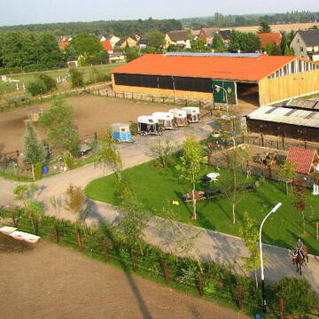
Große Reitanlage in Wipshausen
Wipshausen
Reitpark Krüger
@Reitpark-Krueger
Fahrstall, Kutschwagen
FN-Mitglied
Longierzirkel/Roundpen
Paddock
Allergikerstall
Außenbox mit Paddock
Außenboxen
13 weitere...
P
Deprecated: Creation of dynamic property Zend_View_Helper_Ads::$adLink is deprecated in /var/www/stall-frei/htdocs/staging.stall-frei.de/library/Psf/View/Helper/Ads.php on line 108

Frisches Stroh zu verkaufen!
Mechtersen
STALL-FREIde Marketing
@STALL-FREI-Marketing
Kaufe frisches Stroh für dein Pferd!
Leider kein Vorschaubild
Leider kein Vorschaubild
Pferdeboxen zu vermieten
Wendeburg
B. Boße
@Lisa03
Freizeitstall
Vermieten
Laufband
Paddock
Innenbox
9 weitere...
B
Pferdepension Franke
Didderse
Pferdepension-Franke
@Pferdepension-Franke
Freizeitstall
Vermieten
Führanlage
Longierzirkel/Roundpen
Außenbox mit Paddock
Innenbox
11 weitere...
P

Reit- und Ausbildungsstall Fam. Müller
Didderse
Reitstall Müller Didderse
@Reitstall-Didderse
FN-Mitglied
Freizeitstall
Vermieten
Longierzirkel/Roundpen
Paddock
Hufrehe geeignet
15 weitere...
P
Leider kein Vorschaubild
Leider kein Vorschaubild
Stall mit Weide und Paddock Hohenhameln
Hohenhameln
Christoph Lueders
@ChristophLueders
Vermieten
Paddock
Sommerweide
Selbstversorgung
Einzelne Boxen oder Stallplätze
1 weitere...
B
Leider kein Vorschaubild
Leider kein Vorschaubild
RFV Hohenhameln
Hohenhameln
RFV-Hohenhameln
@RFV-Hohenhameln
FN-Mitglied
Gastronomie
Vermieten
Longierzirkel/Roundpen
Paddock
Außenboxen
Innenbox
12 weitere...
B


Offenstallplätze und Paddockboxen
Altmerdingsen
Reitanlage am Beerbusch
@Reitanlage-am-Beerbusch
Vermieten
Hunde willkommen
Krankenbox
Allergikerstall
Hufrehe geeignet
Außenbox mit Paddock
Bewegungsstall
21 weitere...
P+
Bewegungsstall Fünf Tore in Gretenberg
Sehnde-Gretenberg
Bewegungsstall-Fünf-Tore
@Bewegungsstall-Fuenf-Tore
Freizeitstall
Pferdeausbildung
Vermieten
Krankenbox
Reithalle
Notfallboxen
11 weitere...
P

Persönlichkeitsentwicklung mit Pferden
Bad Salzuflen
Katja Dors
@Pferdezeiten
Begleite andere auf ihrem Entwicklungsweg und entdecke die transformative Kraft der pferdegestützten Persönlichkeitsentwicklung !
neu
R
Leider kein Vorschaubild
Leider kein Vorschaubild
Offenstallplatz frei
Salzgitter bleckenstedt
Anja Heitkamp
@Ladylucie
Freizeitstall
Krankenbox
Paddock
Gnadenbrothof
Notfallboxen
Offenstall
3 weitere...
B

Offenstallplatz, tägl. viel Auslauf, Top Reitmög...
Algermissen
Hanna-Behrens
@Hanna-Behrens
Hunde willkommen
Longierzirkel/Roundpen
bedampftes/gewaschenes Heu
Hufrehe geeignet
Außenboxen
Innenbox
Vollpension
11 weitere...
P
Veröffentliche deine Suche als Gesuch und Suchauftrag, dann erhältst du Angebote, neue Treffer und Änderungen per E-Mail.
Diese Suche als Gesuch veröffentlichenDeprecated: Creation of dynamic property Zend_View::$pageCount is deprecated in /var/www/stall-frei/htdocs/staging.stall-frei.de/library/vendor/shardj/zf1-future/library/Zend/View/Abstract.php on line 308
Deprecated: Creation of dynamic property Zend_View::$itemCountPerPage is deprecated in /var/www/stall-frei/htdocs/staging.stall-frei.de/library/vendor/shardj/zf1-future/library/Zend/View/Abstract.php on line 308
Deprecated: Creation of dynamic property Zend_View::$first is deprecated in /var/www/stall-frei/htdocs/staging.stall-frei.de/library/vendor/shardj/zf1-future/library/Zend/View/Abstract.php on line 308
Deprecated: Creation of dynamic property Zend_View::$current is deprecated in /var/www/stall-frei/htdocs/staging.stall-frei.de/library/vendor/shardj/zf1-future/library/Zend/View/Abstract.php on line 308
Deprecated: Creation of dynamic property Zend_View::$last is deprecated in /var/www/stall-frei/htdocs/staging.stall-frei.de/library/vendor/shardj/zf1-future/library/Zend/View/Abstract.php on line 308
Deprecated: Creation of dynamic property Zend_View::$previous is deprecated in /var/www/stall-frei/htdocs/staging.stall-frei.de/library/vendor/shardj/zf1-future/library/Zend/View/Abstract.php on line 308
Deprecated: Creation of dynamic property Zend_View::$next is deprecated in /var/www/stall-frei/htdocs/staging.stall-frei.de/library/vendor/shardj/zf1-future/library/Zend/View/Abstract.php on line 308
Deprecated: Creation of dynamic property Zend_View::$pagesInRange is deprecated in /var/www/stall-frei/htdocs/staging.stall-frei.de/library/vendor/shardj/zf1-future/library/Zend/View/Abstract.php on line 308
Deprecated: Creation of dynamic property Zend_View::$firstPageInRange is deprecated in /var/www/stall-frei/htdocs/staging.stall-frei.de/library/vendor/shardj/zf1-future/library/Zend/View/Abstract.php on line 308
Deprecated: Creation of dynamic property Zend_View::$lastPageInRange is deprecated in /var/www/stall-frei/htdocs/staging.stall-frei.de/library/vendor/shardj/zf1-future/library/Zend/View/Abstract.php on line 308
Deprecated: Creation of dynamic property Zend_View::$currentItemCount is deprecated in /var/www/stall-frei/htdocs/staging.stall-frei.de/library/vendor/shardj/zf1-future/library/Zend/View/Abstract.php on line 308
Deprecated: Creation of dynamic property Zend_View::$totalItemCount is deprecated in /var/www/stall-frei/htdocs/staging.stall-frei.de/library/vendor/shardj/zf1-future/library/Zend/View/Abstract.php on line 308
Deprecated: Creation of dynamic property Zend_View::$firstItemNumber is deprecated in /var/www/stall-frei/htdocs/staging.stall-frei.de/library/vendor/shardj/zf1-future/library/Zend/View/Abstract.php on line 308
Deprecated: Creation of dynamic property Zend_View::$lastItemNumber is deprecated in /var/www/stall-frei/htdocs/staging.stall-frei.de/library/vendor/shardj/zf1-future/library/Zend/View/Abstract.php on line 308
Deprecated: Creation of dynamic property Zend_View::$router is deprecated in /var/www/stall-frei/htdocs/staging.stall-frei.de/library/vendor/shardj/zf1-future/library/Zend/View/Abstract.php on line 308
Deprecated: Creation of dynamic property Zend_View::$urlParams is deprecated in /var/www/stall-frei/htdocs/staging.stall-frei.de/library/vendor/shardj/zf1-future/library/Zend/View/Abstract.php on line 308
Deprecated: Creation of dynamic property Zend_View::$showAds is deprecated in /var/www/stall-frei/htdocs/staging.stall-frei.de/library/vendor/shardj/zf1-future/library/Zend/View/Abstract.php on line 308
Deprecated: Creation of dynamic property Zend_View::$objectIds is deprecated in /var/www/stall-frei/htdocs/staging.stall-frei.de/library/vendor/shardj/zf1-future/library/Zend/View/Abstract.php on line 308
Deprecated: Creation of dynamic property Zend_View::$showNavbar is deprecated in /var/www/stall-frei/htdocs/staging.stall-frei.de/library/vendor/shardj/zf1-future/library/Zend/View/Abstract.php on line 308
Deprecated: Creation of dynamic property Zend_View::$showBreadcrumb is deprecated in /var/www/stall-frei/htdocs/staging.stall-frei.de/library/vendor/shardj/zf1-future/library/Zend/View/Abstract.php on line 308
Deprecated: Creation of dynamic property Zend_View::$showFooter is deprecated in /var/www/stall-frei/htdocs/staging.stall-frei.de/library/vendor/shardj/zf1-future/library/Zend/View/Abstract.php on line 308
Deprecated: Creation of dynamic property Zend_View::$showInternalAds is deprecated in /var/www/stall-frei/htdocs/staging.stall-frei.de/library/vendor/shardj/zf1-future/library/Zend/View/Abstract.php on line 308
Deprecated: Creation of dynamic property Zend_View::$blNoContent is deprecated in /var/www/stall-frei/htdocs/staging.stall-frei.de/library/vendor/shardj/zf1-future/library/Zend/View/Abstract.php on line 308
Deprecated: Creation of dynamic property Zend_View::$sMetaDesc is deprecated in /var/www/stall-frei/htdocs/staging.stall-frei.de/library/vendor/shardj/zf1-future/library/Zend/View/Abstract.php on line 308
Deprecated: Creation of dynamic property Zend_View::$useGmaps is deprecated in /var/www/stall-frei/htdocs/staging.stall-frei.de/library/vendor/shardj/zf1-future/library/Zend/View/Abstract.php on line 308
Deprecated: Creation of dynamic property Zend_View::$touches is deprecated in /var/www/stall-frei/htdocs/staging.stall-frei.de/library/vendor/shardj/zf1-future/library/Zend/View/Abstract.php on line 308
Deprecated: Creation of dynamic property Zend_View::$oProject is deprecated in /var/www/stall-frei/htdocs/staging.stall-frei.de/library/vendor/shardj/zf1-future/library/Zend/View/Abstract.php on line 308
Deprecated: Creation of dynamic property Zend_View::$pageHeadline is deprecated in /var/www/stall-frei/htdocs/staging.stall-frei.de/library/vendor/shardj/zf1-future/library/Zend/View/Abstract.php on line 308
Deprecated: Creation of dynamic property Zend_View::$disableLocationField is deprecated in /var/www/stall-frei/htdocs/staging.stall-frei.de/library/vendor/shardj/zf1-future/library/Zend/View/Abstract.php on line 308
Deprecated: Creation of dynamic property Zend_View::$isSearch is deprecated in /var/www/stall-frei/htdocs/staging.stall-frei.de/library/vendor/shardj/zf1-future/library/Zend/View/Abstract.php on line 308
Deprecated: Creation of dynamic property Zend_View::$pageTitle is deprecated in /var/www/stall-frei/htdocs/staging.stall-frei.de/library/vendor/shardj/zf1-future/library/Zend/View/Abstract.php on line 308
Deprecated: Creation of dynamic property Psf_Form_Element_Text::$class is deprecated in /var/www/stall-frei/htdocs/staging.stall-frei.de/library/vendor/shardj/zf1-future/library/Zend/Form/Element.php on line 874
Deprecated: Creation of dynamic property Psf_Form_Element_Text::$size is deprecated in /var/www/stall-frei/htdocs/staging.stall-frei.de/library/vendor/shardj/zf1-future/library/Zend/Form/Element.php on line 874
Deprecated: Creation of dynamic property Psf_Form_Element_Text::$placeholder is deprecated in /var/www/stall-frei/htdocs/staging.stall-frei.de/library/vendor/shardj/zf1-future/library/Zend/Form/Element.php on line 874
Deprecated: Creation of dynamic property Psf_Form_Element_Hidden::$class is deprecated in /var/www/stall-frei/htdocs/staging.stall-frei.de/library/vendor/shardj/zf1-future/library/Zend/Form/Element.php on line 874
Deprecated: Creation of dynamic property Psf_Form_Element_Hidden::$class is deprecated in /var/www/stall-frei/htdocs/staging.stall-frei.de/library/vendor/shardj/zf1-future/library/Zend/Form/Element.php on line 874
Deprecated: Creation of dynamic property Psf_Form_Element_Hidden::$class is deprecated in /var/www/stall-frei/htdocs/staging.stall-frei.de/library/vendor/shardj/zf1-future/library/Zend/Form/Element.php on line 874
Deprecated: Creation of dynamic property Psf_Form_Element_Hidden::$class is deprecated in /var/www/stall-frei/htdocs/staging.stall-frei.de/library/vendor/shardj/zf1-future/library/Zend/Form/Element.php on line 874
Deprecated: Creation of dynamic property Psf_Form_Element_Select::$class is deprecated in /var/www/stall-frei/htdocs/staging.stall-frei.de/library/vendor/shardj/zf1-future/library/Zend/Form/Element.php on line 874
Deprecated: Creation of dynamic property Psf_Form_Element_Select::$class is deprecated in /var/www/stall-frei/htdocs/staging.stall-frei.de/library/vendor/shardj/zf1-future/library/Zend/Form/Element.php on line 874
Deprecated: Creation of dynamic property Psf_Form_Element_Select::$class is deprecated in /var/www/stall-frei/htdocs/staging.stall-frei.de/library/vendor/shardj/zf1-future/library/Zend/Form/Element.php on line 874
Deprecated: Creation of dynamic property Psf_Form_Element_Select::$class is deprecated in /var/www/stall-frei/htdocs/staging.stall-frei.de/library/vendor/shardj/zf1-future/library/Zend/Form/Element.php on line 874
Deprecated: Creation of dynamic property Psf_Form_Element_Text::$class is deprecated in /var/www/stall-frei/htdocs/staging.stall-frei.de/library/vendor/shardj/zf1-future/library/Zend/Form/Element.php on line 874
Deprecated: Creation of dynamic property Psf_Form_Element_Checkbox::$label is deprecated in /var/www/stall-frei/htdocs/staging.stall-frei.de/library/vendor/shardj/zf1-future/library/Zend/Form/Element.php on line 874
Deprecated: Creation of dynamic property Zend_View::$sort is deprecated in /var/www/stall-frei/htdocs/staging.stall-frei.de/library/vendor/shardj/zf1-future/library/Zend/View/Abstract.php on line 308
Deprecated: Creation of dynamic property Zend_View::$searchLocation is deprecated in /var/www/stall-frei/htdocs/staging.stall-frei.de/library/vendor/shardj/zf1-future/library/Zend/View/Abstract.php on line 308
Deprecated: Creation of dynamic property Zend_View::$locationHint is deprecated in /var/www/stall-frei/htdocs/staging.stall-frei.de/library/vendor/shardj/zf1-future/library/Zend/View/Abstract.php on line 308
Psf_GeoCoder_Abstract::getLocation: Oberg Get Location CachedOrLive
Psf_GeoCoder_Abstract::getCachedOrLive: Oberg
Psf_GeoCoder_Abstract::convertLocationResult
{"documentation":"https:\/\/opencagedata.com\/api","licenses":[{"name":"see attribution guide","url":"https:\/\/opencagedata.com\/credits"}],"results":[{"bounds":{"northeast":{"lat":52.2834891,"lng":10.2741187},"southwest":{"lat":52.2395558,"lng":10.2326}},"components":{"ISO_3166-1_alpha-2":"DE","ISO_3166-1_alpha-3":"DEU","ISO_3166-2":["DE-NI"],"_category":"place","_normalized_city":"Ilsede","_type":"village","continent":"Europe","country":"Deutschland","country_code":"de","county":"Landkreis Peine","political_union":"European Union","state":"Niedersachsen","state_code":"NI","town":"Ilsede","village":"Oberg"},"confidence":7,"formatted":"Oberg, Niedersachsen, Deutschland","geometry":{"lat":52.256199,"lng":10.2504044}},{"bounds":{"northeast":{"lat":54.0656633,"lng":10.0757979},"southwest":{"lat":54.0655633,"lng":10.0756979}},"components":{"ISO_3166-1_alpha-2":"DE","ISO_3166-1_alpha-3":"DEU","ISO_3166-2":["DE-SH"],"_category":"natural\/water","_normalized_city":"B\u00f6neb\u00fcttel","_type":"peak","continent":"Europe","country":"Deutschland","country_code":"de","county":"Kreis Pl\u00f6n","peak":"Oberg","political_union":"European Union","postcode":"24620","state":"Schleswig-Holstein","state_code":"SH","village":"B\u00f6neb\u00fcttel"},"confidence":9,"formatted":"Oberg, 24620 B\u00f6neb\u00fcttel, Deutschland","geometry":{"lat":54.0656133,"lng":10.0757479}},{"bounds":{"northeast":{"lat":49.930017,"lng":8.0333833},"southwest":{"lat":49.9275376,"lng":8.027618}},"components":{"ISO_3166-1_alpha-2":"DE","ISO_3166-1_alpha-3":"DEU","ISO_3166-2":["DE-RP"],"_category":"road","_normalized_city":"Appenheim","_type":"road","continent":"Europe","country":"Deutschland","country_code":"de","county":"Landkreis Mainz-Bingen","municipality":"Gau-Algesheim","political_union":"European Union","postcode":"55437","road":"Obergasse","road_type":"tertiary","state":"Rheinland-Pfalz","state_code":"RP","village":"Appenheim"},"confidence":9,"formatted":"Obergasse, 55437 Appenheim, Deutschland","geometry":{"lat":49.9283591,"lng":8.0306216}},{"bounds":{"northeast":{"lat":49.7267936,"lng":8.0344805},"southwest":{"lat":49.7255641,"lng":8.0318942}},"components":{"ISO_3166-1_alpha-2":"DE","ISO_3166-1_alpha-3":"DEU","ISO_3166-2":["DE-RP"],"_category":"road","_normalized_city":"Offenheim","_type":"road","continent":"Europe","country":"Deutschland","country_code":"de","county":"Landkreis Alzey-Worms","municipality":"Alzey-Land","political_union":"European Union","postcode":"55234","road":"Obergasse","road_type":"secondary","state":"Rheinland-Pfalz","state_code":"RP","village":"Offenheim"},"confidence":9,"formatted":"Obergasse, 55234 Offenheim, Deutschland","geometry":{"lat":49.726163,"lng":8.0331945}},{"bounds":{"northeast":{"lat":49.7277945,"lng":8.0027645},"southwest":{"lat":49.725785,"lng":8.002058}},"components":{"ISO_3166-1_alpha-2":"DE","ISO_3166-1_alpha-3":"DEU","ISO_3166-2":["DE-RP"],"_category":"road","_normalized_city":"Bechenheim","_type":"road","continent":"Europe","country":"Deutschland","country_code":"de","county":"Landkreis Alzey-Worms","municipality":"Alzey-Land","political_union":"European Union","postcode":"55234","road":"Obergasse","road_type":"secondary","state":"Rheinland-Pfalz","state_code":"RP","village":"Bechenheim"},"confidence":9,"formatted":"Obergasse, 55234 Bechenheim, Deutschland","geometry":{"lat":49.7267833,"lng":8.0024442}},{"bounds":{"northeast":{"lat":49.9446961,"lng":8.0845622},"southwest":{"lat":49.9434497,"lng":8.0835965}},"components":{"ISO_3166-1_alpha-2":"DE","ISO_3166-1_alpha-3":"DEU","ISO_3166-2":["DE-RP"],"_category":"road","_normalized_city":"Ingelheim am Rhein","_type":"road","continent":"Europe","country":"Deutschland","country_code":"de","county":"Landkreis Mainz-Bingen","political_union":"European Union","postcode":"55218","road":"Obergasse","road_type":"residential","state":"Rheinland-Pfalz","state_code":"RP","town":"Ingelheim am Rhein","village":"Gro\u00dfwinternheim"},"confidence":9,"formatted":"Obergasse, 55218 Gro\u00dfwinternheim, Deutschland","geometry":{"lat":49.9441231,"lng":8.084096}},{"bounds":{"northeast":{"lat":49.9051528,"lng":8.2625251},"southwest":{"lat":49.9043737,"lng":8.261159}},"components":{"ISO_3166-1_alpha-2":"DE","ISO_3166-1_alpha-3":"DEU","ISO_3166-2":["DE-RP"],"_category":"road","_normalized_city":"Harxheim","_type":"road","continent":"Europe","country":"Deutschland","country_code":"de","county":"Landkreis Mainz-Bingen","municipality":"Bodenheim","political_union":"European Union","postcode":"55296","road":"Obergasse","road_type":"residential","state":"Rheinland-Pfalz","state_code":"RP","village":"Harxheim"},"confidence":9,"formatted":"Obergasse, 55296 Harxheim, Deutschland","geometry":{"lat":49.9049726,"lng":8.2616627}},{"bounds":{"northeast":{"lat":49.778732,"lng":8.0975564},"southwest":{"lat":49.778054,"lng":8.096184}},"components":{"ISO_3166-1_alpha-2":"DE","ISO_3166-1_alpha-3":"DEU","ISO_3166-2":["DE-RP"],"_category":"road","_normalized_city":"Bermersheim vor der H\u00f6he","_type":"road","continent":"Europe","country":"Deutschland","country_code":"de","county":"Landkreis Alzey-Worms","municipality":"Alzey-Land","political_union":"European Union","postcode":"55234","road":"Obergasse","road_type":"residential","state":"Rheinland-Pfalz","state_code":"RP","village":"Bermersheim vor der H\u00f6he"},"confidence":9,"formatted":"Obergasse, 55234 Bermersheim vor der H\u00f6he, Deutschland","geometry":{"lat":49.7783875,"lng":8.0968682}},{"bounds":{"northeast":{"lat":50.1357902,"lng":8.301482},"southwest":{"lat":50.1351951,"lng":8.3001587}},"components":{"ISO_3166-1_alpha-2":"DE","ISO_3166-1_alpha-3":"DEU","ISO_3166-2":["DE-HE"],"_category":"road","_normalized_city":"Wiesbaden","_type":"road","city":"Wiesbaden","continent":"Europe","country":"Deutschland","country_code":"de","political_union":"European Union","postcode":"65207","road":"Obergasse","road_type":"living_street","state":"Hessen","state_code":"HE","village":"Naurod"},"confidence":9,"formatted":"Obergasse, 65207 Naurod, Deutschland","geometry":{"lat":50.1354672,"lng":8.3008081}},{"bounds":{"northeast":{"lat":49.4807263,"lng":7.6287647},"southwest":{"lat":49.4784495,"lng":7.6285082}},"components":{"ISO_3166-1_alpha-2":"DE","ISO_3166-1_alpha-3":"DEU","ISO_3166-2":["DE-RP"],"_category":"road","_normalized_city":"Weilerbach","_type":"road","continent":"Europe","country":"Deutschland","country_code":"de","county":"Landkreis Kaiserslautern","municipality":"Weilerbach","political_union":"European Union","postcode":"67685","road":"Obergasse","road_type":"residential","state":"Rheinland-Pfalz","state_code":"RP","village":"Weilerbach"},"confidence":9,"formatted":"Obergasse, 67685 Weilerbach, Deutschland","geometry":{"lat":49.4795877,"lng":7.6286423}}],"status":{"code":200,"message":"OK"},"stay_informed":{"blog":"https:\/\/blog.opencagedata.com","mastodon":"https:\/\/en.osm.town\/@opencage"},"thanks":"For using an OpenCage API","timestamp":{"created_http":"Sun, 08 Feb 2026 00:03:17 GMT","created_unix":1770508997},"total_results":10}Array
(
[0] => stdClass Object
(
[bounds] => stdClass Object
(
[northeast] => stdClass Object
(
[lat] => 52.2834891
[lng] => 10.2741187
)
[southwest] => stdClass Object
(
[lat] => 52.2395558
[lng] => 10.2326
)
)
[components] => stdClass Object
(
[ISO_3166-1_alpha-2] => DE
[ISO_3166-1_alpha-3] => DEU
[ISO_3166-2] => Array
(
[0] => DE-NI
)
[_category] => place
[_normalized_city] => Ilsede
[_type] => village
[continent] => Europe
[country] => Deutschland
[country_code] => de
[county] => Landkreis Peine
[political_union] => European Union
[state] => Niedersachsen
[state_code] => NI
[town] => Ilsede
[village] => Oberg
)
[confidence] => 7
[formatted] => Oberg, Niedersachsen, Deutschland
[geometry] => stdClass Object
(
[lat] => 52.256199
[lng] => 10.2504044
)
)
[1] => stdClass Object
(
[bounds] => stdClass Object
(
[northeast] => stdClass Object
(
[lat] => 54.0656633
[lng] => 10.0757979
)
[southwest] => stdClass Object
(
[lat] => 54.0655633
[lng] => 10.0756979
)
)
[components] => stdClass Object
(
[ISO_3166-1_alpha-2] => DE
[ISO_3166-1_alpha-3] => DEU
[ISO_3166-2] => Array
(
[0] => DE-SH
)
[_category] => natural/water
[_normalized_city] => Bönebüttel
[_type] => peak
[continent] => Europe
[country] => Deutschland
[country_code] => de
[county] => Kreis Plön
[peak] => Oberg
[political_union] => European Union
[postcode] => 24620
[state] => Schleswig-Holstein
[state_code] => SH
[village] => Bönebüttel
)
[confidence] => 9
[formatted] => Oberg, 24620 Bönebüttel, Deutschland
[geometry] => stdClass Object
(
[lat] => 54.0656133
[lng] => 10.0757479
)
)
[2] => stdClass Object
(
[bounds] => stdClass Object
(
[northeast] => stdClass Object
(
[lat] => 49.930017
[lng] => 8.0333833
)
[southwest] => stdClass Object
(
[lat] => 49.9275376
[lng] => 8.027618
)
)
[components] => stdClass Object
(
[ISO_3166-1_alpha-2] => DE
[ISO_3166-1_alpha-3] => DEU
[ISO_3166-2] => Array
(
[0] => DE-RP
)
[_category] => road
[_normalized_city] => Appenheim
[_type] => road
[continent] => Europe
[country] => Deutschland
[country_code] => de
[county] => Landkreis Mainz-Bingen
[municipality] => Gau-Algesheim
[political_union] => European Union
[postcode] => 55437
[road] => Obergasse
[road_type] => tertiary
[state] => Rheinland-Pfalz
[state_code] => RP
[village] => Appenheim
)
[confidence] => 9
[formatted] => Obergasse, 55437 Appenheim, Deutschland
[geometry] => stdClass Object
(
[lat] => 49.9283591
[lng] => 8.0306216
)
)
[3] => stdClass Object
(
[bounds] => stdClass Object
(
[northeast] => stdClass Object
(
[lat] => 49.7267936
[lng] => 8.0344805
)
[southwest] => stdClass Object
(
[lat] => 49.7255641
[lng] => 8.0318942
)
)
[components] => stdClass Object
(
[ISO_3166-1_alpha-2] => DE
[ISO_3166-1_alpha-3] => DEU
[ISO_3166-2] => Array
(
[0] => DE-RP
)
[_category] => road
[_normalized_city] => Offenheim
[_type] => road
[continent] => Europe
[country] => Deutschland
[country_code] => de
[county] => Landkreis Alzey-Worms
[municipality] => Alzey-Land
[political_union] => European Union
[postcode] => 55234
[road] => Obergasse
[road_type] => secondary
[state] => Rheinland-Pfalz
[state_code] => RP
[village] => Offenheim
)
[confidence] => 9
[formatted] => Obergasse, 55234 Offenheim, Deutschland
[geometry] => stdClass Object
(
[lat] => 49.726163
[lng] => 8.0331945
)
)
[4] => stdClass Object
(
[bounds] => stdClass Object
(
[northeast] => stdClass Object
(
[lat] => 49.7277945
[lng] => 8.0027645
)
[southwest] => stdClass Object
(
[lat] => 49.725785
[lng] => 8.002058
)
)
[components] => stdClass Object
(
[ISO_3166-1_alpha-2] => DE
[ISO_3166-1_alpha-3] => DEU
[ISO_3166-2] => Array
(
[0] => DE-RP
)
[_category] => road
[_normalized_city] => Bechenheim
[_type] => road
[continent] => Europe
[country] => Deutschland
[country_code] => de
[county] => Landkreis Alzey-Worms
[municipality] => Alzey-Land
[political_union] => European Union
[postcode] => 55234
[road] => Obergasse
[road_type] => secondary
[state] => Rheinland-Pfalz
[state_code] => RP
[village] => Bechenheim
)
[confidence] => 9
[formatted] => Obergasse, 55234 Bechenheim, Deutschland
[geometry] => stdClass Object
(
[lat] => 49.7267833
[lng] => 8.0024442
)
)
[5] => stdClass Object
(
[bounds] => stdClass Object
(
[northeast] => stdClass Object
(
[lat] => 49.9446961
[lng] => 8.0845622
)
[southwest] => stdClass Object
(
[lat] => 49.9434497
[lng] => 8.0835965
)
)
[components] => stdClass Object
(
[ISO_3166-1_alpha-2] => DE
[ISO_3166-1_alpha-3] => DEU
[ISO_3166-2] => Array
(
[0] => DE-RP
)
[_category] => road
[_normalized_city] => Ingelheim am Rhein
[_type] => road
[continent] => Europe
[country] => Deutschland
[country_code] => de
[county] => Landkreis Mainz-Bingen
[political_union] => European Union
[postcode] => 55218
[road] => Obergasse
[road_type] => residential
[state] => Rheinland-Pfalz
[state_code] => RP
[town] => Ingelheim am Rhein
[village] => Großwinternheim
)
[confidence] => 9
[formatted] => Obergasse, 55218 Großwinternheim, Deutschland
[geometry] => stdClass Object
(
[lat] => 49.9441231
[lng] => 8.084096
)
)
[6] => stdClass Object
(
[bounds] => stdClass Object
(
[northeast] => stdClass Object
(
[lat] => 49.9051528
[lng] => 8.2625251
)
[southwest] => stdClass Object
(
[lat] => 49.9043737
[lng] => 8.261159
)
)
[components] => stdClass Object
(
[ISO_3166-1_alpha-2] => DE
[ISO_3166-1_alpha-3] => DEU
[ISO_3166-2] => Array
(
[0] => DE-RP
)
[_category] => road
[_normalized_city] => Harxheim
[_type] => road
[continent] => Europe
[country] => Deutschland
[country_code] => de
[county] => Landkreis Mainz-Bingen
[municipality] => Bodenheim
[political_union] => European Union
[postcode] => 55296
[road] => Obergasse
[road_type] => residential
[state] => Rheinland-Pfalz
[state_code] => RP
[village] => Harxheim
)
[confidence] => 9
[formatted] => Obergasse, 55296 Harxheim, Deutschland
[geometry] => stdClass Object
(
[lat] => 49.9049726
[lng] => 8.2616627
)
)
[7] => stdClass Object
(
[bounds] => stdClass Object
(
[northeast] => stdClass Object
(
[lat] => 49.778732
[lng] => 8.0975564
)
[southwest] => stdClass Object
(
[lat] => 49.778054
[lng] => 8.096184
)
)
[components] => stdClass Object
(
[ISO_3166-1_alpha-2] => DE
[ISO_3166-1_alpha-3] => DEU
[ISO_3166-2] => Array
(
[0] => DE-RP
)
[_category] => road
[_normalized_city] => Bermersheim vor der Höhe
[_type] => road
[continent] => Europe
[country] => Deutschland
[country_code] => de
[county] => Landkreis Alzey-Worms
[municipality] => Alzey-Land
[political_union] => European Union
[postcode] => 55234
[road] => Obergasse
[road_type] => residential
[state] => Rheinland-Pfalz
[state_code] => RP
[village] => Bermersheim vor der Höhe
)
[confidence] => 9
[formatted] => Obergasse, 55234 Bermersheim vor der Höhe, Deutschland
[geometry] => stdClass Object
(
[lat] => 49.7783875
[lng] => 8.0968682
)
)
[8] => stdClass Object
(
[bounds] => stdClass Object
(
[northeast] => stdClass Object
(
[lat] => 50.1357902
[lng] => 8.301482
)
[southwest] => stdClass Object
(
[lat] => 50.1351951
[lng] => 8.3001587
)
)
[components] => stdClass Object
(
[ISO_3166-1_alpha-2] => DE
[ISO_3166-1_alpha-3] => DEU
[ISO_3166-2] => Array
(
[0] => DE-HE
)
[_category] => road
[_normalized_city] => Wiesbaden
[_type] => road
[city] => Wiesbaden
[continent] => Europe
[country] => Deutschland
[country_code] => de
[political_union] => European Union
[postcode] => 65207
[road] => Obergasse
[road_type] => living_street
[state] => Hessen
[state_code] => HE
[village] => Naurod
)
[confidence] => 9
[formatted] => Obergasse, 65207 Naurod, Deutschland
[geometry] => stdClass Object
(
[lat] => 50.1354672
[lng] => 8.3008081
)
)
[9] => stdClass Object
(
[bounds] => stdClass Object
(
[northeast] => stdClass Object
(
[lat] => 49.4807263
[lng] => 7.6287647
)
[southwest] => stdClass Object
(
[lat] => 49.4784495
[lng] => 7.6285082
)
)
[components] => stdClass Object
(
[ISO_3166-1_alpha-2] => DE
[ISO_3166-1_alpha-3] => DEU
[ISO_3166-2] => Array
(
[0] => DE-RP
)
[_category] => road
[_normalized_city] => Weilerbach
[_type] => road
[continent] => Europe
[country] => Deutschland
[country_code] => de
[county] => Landkreis Kaiserslautern
[municipality] => Weilerbach
[political_union] => European Union
[postcode] => 67685
[road] => Obergasse
[road_type] => residential
[state] => Rheinland-Pfalz
[state_code] => RP
[village] => Weilerbach
)
[confidence] => 9
[formatted] => Obergasse, 67685 Weilerbach, Deutschland
[geometry] => stdClass Object
(
[lat] => 49.4795877
[lng] => 7.6286423
)
)
)
Psf_GeoCoder_OpenCageData::getKeyMap: 0
stdClass Object
(
    [bounds] => stdClass Object
        (
            [northeast] => stdClass Object
                (
                    [lat] => 52.2834891
                    [lng] => 10.2741187
                )

            [southwest] => stdClass Object
                (
                    [lat] => 52.2395558
                    [lng] => 10.2326
                )

        )

    [components] => stdClass Object
        (
            [ISO_3166-1_alpha-2] => DE
            [ISO_3166-1_alpha-3] => DEU
            [ISO_3166-2] => Array
                (
                    [0] => DE-NI
                )

            [_category] => place
            [_normalized_city] => Ilsede
            [_type] => village
            [continent] => Europe
            [country] => Deutschland
            [country_code] => de
            [county] => Landkreis Peine
            [political_union] => European Union
            [state] => Niedersachsen
            [state_code] => NI
            [town] => Ilsede
            [village] => Oberg
        )

    [confidence] => 7
    [formatted] => Oberg, Niedersachsen, Deutschland
    [geometry] => stdClass Object
        (
            [lat] => 52.256199
            [lng] => 10.2504044
        )

)
Psf_GeoCoder_OpenCageData::getCounty: Peine
Psf_GeoCoder_OpenCageData::addMissingData REFETCH!
Array
(
    [address] => Oberg, Niedersachsen, Deutschland
    [type] => village
    [street] =>
    [city] => Ilsede
    [county] => Peine
    [state] => Niedersachsen
    [zip] =>
    [country] => Deutschland
    [suburb] =>
    [countrycode] => de
    [latitude] => 52.256199
    [longitude] => 10.2504044
    [accuracy] => 1
    [confidence] => 7
    [bounds] => stdClass Object
        (
            [northeast] => stdClass Object
                (
                    [lat] => 52.2834891
                    [lng] => 10.2741187
                )

            [southwest] => stdClass Object
                (
                    [lat] => 52.2395558
                    [lng] => 10.2326
                )

        )

)
reformat!
Array
(
    [address] => Ilsede
    [type] => village
    [street] =>
    [city] => Ilsede
    [county] => Peine
    [state] => Niedersachsen
    [zip] =>
    [country] => Deutschland
    [suburb] =>
    [countrycode] => de
    [latitude] => 52.256199
    [longitude] => 10.2504044
    [accuracy] => 1
    [confidence] => 7
    [bounds] => stdClass Object
        (
            [northeast] => stdClass Object
                (
                    [lat] => 52.2834891
                    [lng] => 10.2741187
                )

            [southwest] => stdClass Object
                (
                    [lat] => 52.2395558
                    [lng] => 10.2326
                )

        )

    [place] => Ilsede, Niedersachsen
    [hash] => 859fad14eef436f5aa353c1356d954a2
)
Psf_GeoCoder_OpenCageData::getKeyMap: 1
stdClass Object
(
    [bounds] => stdClass Object
        (
            [northeast] => stdClass Object
                (
                    [lat] => 54.0656633
                    [lng] => 10.0757979
                )

            [southwest] => stdClass Object
                (
                    [lat] => 54.0655633
                    [lng] => 10.0756979
                )

        )

    [components] => stdClass Object
        (
            [ISO_3166-1_alpha-2] => DE
            [ISO_3166-1_alpha-3] => DEU
            [ISO_3166-2] => Array
                (
                    [0] => DE-SH
                )

            [_category] => natural/water
            [_normalized_city] => Bönebüttel
            [_type] => peak
            [continent] => Europe
            [country] => Deutschland
            [country_code] => de
            [county] => Kreis Plön
            [peak] => Oberg
            [political_union] => European Union
            [postcode] => 24620
            [state] => Schleswig-Holstein
            [state_code] => SH
            [village] => Bönebüttel
        )

    [confidence] => 9
    [formatted] => Oberg, 24620 Bönebüttel, Deutschland
    [geometry] => stdClass Object
        (
            [lat] => 54.0656133
            [lng] => 10.0757479
        )

)
Psf_GeoCoder_OpenCageData::getCounty: Plön
Psf_GeoCoder_OpenCageData::addMissingData REFETCH!
Array
(
    [address] => Oberg, 24620 Bönebüttel, Deutschland
    [type] => peak
    [street] =>
    [city] => Bönebüttel
    [county] => Plön
    [state] => Schleswig-Holstein
    [zip] => 24620
    [country] => Deutschland
    [suburb] =>
    [countrycode] => de
    [latitude] => 54.0656133
    [longitude] => 10.0757479
    [accuracy] => 1
    [confidence] => 9
    [bounds] => stdClass Object
        (
            [northeast] => stdClass Object
                (
                    [lat] => 54.0656633
                    [lng] => 10.0757979
                )

            [southwest] => stdClass Object
                (
                    [lat] => 54.0655633
                    [lng] => 10.0756979
                )

        )

)
reformat!
Array
(
    [address] => Oberg, 24620 Bönebüttel, Deutschland
    [type] => peak
    [street] =>
    [city] => Bönebüttel
    [county] => Plön
    [state] => Schleswig-Holstein
    [zip] => 24620
    [country] => Deutschland
    [suburb] =>
    [countrycode] => de
    [latitude] => 54.0656133
    [longitude] => 10.0757479
    [accuracy] => 1
    [confidence] => 9
    [bounds] => stdClass Object
        (
            [northeast] => stdClass Object
                (
                    [lat] => 54.0656633
                    [lng] => 10.0757979
                )

            [southwest] => stdClass Object
                (
                    [lat] => 54.0655633
                    [lng] => 10.0756979
                )

        )

    [place] => 24620 Bönebüttel, Schleswig-Holstein
    [hash] => e283afae904e10f824b1b8552288dfad
)
Psf_GeoCoder_OpenCageData::getKeyMap: 2
stdClass Object
(
    [bounds] => stdClass Object
        (
            [northeast] => stdClass Object
                (
                    [lat] => 49.930017
                    [lng] => 8.0333833
                )

            [southwest] => stdClass Object
                (
                    [lat] => 49.9275376
                    [lng] => 8.027618
                )

        )

    [components] => stdClass Object
        (
            [ISO_3166-1_alpha-2] => DE
            [ISO_3166-1_alpha-3] => DEU
            [ISO_3166-2] => Array
                (
                    [0] => DE-RP
                )

            [_category] => road
            [_normalized_city] => Appenheim
            [_type] => road
            [continent] => Europe
            [country] => Deutschland
            [country_code] => de
            [county] => Landkreis Mainz-Bingen
            [municipality] => Gau-Algesheim
            [political_union] => European Union
            [postcode] => 55437
            [road] => Obergasse
            [road_type] => tertiary
            [state] => Rheinland-Pfalz
            [state_code] => RP
            [village] => Appenheim
        )

    [confidence] => 9
    [formatted] => Obergasse, 55437 Appenheim, Deutschland
    [geometry] => stdClass Object
        (
            [lat] => 49.9283591
            [lng] => 8.0306216
        )

)
Psf_GeoCoder_OpenCageData::getCounty: Mainz-Bingen
Psf_GeoCoder_OpenCageData::addMissingData REFETCH!
Array
(
    [address] => Obergasse, 55437 Appenheim, Deutschland
    [type] => road
    [street] => Obergasse
    [city] => Appenheim
    [county] => Mainz-Bingen
    [state] => Rheinland-Pfalz
    [zip] => 55437
    [country] => Deutschland
    [suburb] =>
    [countrycode] => de
    [latitude] => 49.9283591
    [longitude] => 8.0306216
    [accuracy] => 1
    [confidence] => 9
    [bounds] => stdClass Object
        (
            [northeast] => stdClass Object
                (
                    [lat] => 49.930017
                    [lng] => 8.0333833
                )

            [southwest] => stdClass Object
                (
                    [lat] => 49.9275376
                    [lng] => 8.027618
                )

        )

)
reformat!
Array
(
    [address] => Obergasse, 55437 Appenheim, Deutschland
    [type] => road
    [street] => Obergasse
    [city] => Appenheim
    [county] => Mainz-Bingen
    [state] => Rheinland-Pfalz
    [zip] => 55437
    [country] => Deutschland
    [suburb] =>
    [countrycode] => de
    [latitude] => 49.9283591
    [longitude] => 8.0306216
    [accuracy] => 1
    [confidence] => 9
    [bounds] => stdClass Object
        (
            [northeast] => stdClass Object
                (
                    [lat] => 49.930017
                    [lng] => 8.0333833
                )

            [southwest] => stdClass Object
                (
                    [lat] => 49.9275376
                    [lng] => 8.027618
                )

        )

    [place] => Obergasse, 55437 Appenheim, Rheinland-Pfalz
    [hash] => fc4770608ce0303e672ca0d879b809b6
)
Psf_GeoCoder_OpenCageData::getKeyMap: 3
stdClass Object
(
    [bounds] => stdClass Object
        (
            [northeast] => stdClass Object
                (
                    [lat] => 49.7267936
                    [lng] => 8.0344805
                )

            [southwest] => stdClass Object
                (
                    [lat] => 49.7255641
                    [lng] => 8.0318942
                )

        )

    [components] => stdClass Object
        (
            [ISO_3166-1_alpha-2] => DE
            [ISO_3166-1_alpha-3] => DEU
            [ISO_3166-2] => Array
                (
                    [0] => DE-RP
                )

            [_category] => road
            [_normalized_city] => Offenheim
            [_type] => road
            [continent] => Europe
            [country] => Deutschland
            [country_code] => de
            [county] => Landkreis Alzey-Worms
            [municipality] => Alzey-Land
            [political_union] => European Union
            [postcode] => 55234
            [road] => Obergasse
            [road_type] => secondary
            [state] => Rheinland-Pfalz
            [state_code] => RP
            [village] => Offenheim
        )

    [confidence] => 9
    [formatted] => Obergasse, 55234 Offenheim, Deutschland
    [geometry] => stdClass Object
        (
            [lat] => 49.726163
            [lng] => 8.0331945
        )

)
Psf_GeoCoder_OpenCageData::getCounty: Alzey-Worms
Psf_GeoCoder_OpenCageData::addMissingData REFETCH!
Array
(
    [address] => Obergasse, 55234 Offenheim, Deutschland
    [type] => road
    [street] => Obergasse
    [city] => Offenheim
    [county] => Alzey-Worms
    [state] => Rheinland-Pfalz
    [zip] => 55234
    [country] => Deutschland
    [suburb] =>
    [countrycode] => de
    [latitude] => 49.726163
    [longitude] => 8.0331945
    [accuracy] => 1
    [confidence] => 9
    [bounds] => stdClass Object
        (
            [northeast] => stdClass Object
                (
                    [lat] => 49.7267936
                    [lng] => 8.0344805
                )

            [southwest] => stdClass Object
                (
                    [lat] => 49.7255641
                    [lng] => 8.0318942
                )

        )

)
reformat!
Array
(
    [address] => Obergasse, 55234 Offenheim, Deutschland
    [type] => road
    [street] => Obergasse
    [city] => Offenheim
    [county] => Alzey-Worms
    [state] => Rheinland-Pfalz
    [zip] => 55234
    [country] => Deutschland
    [suburb] =>
    [countrycode] => de
    [latitude] => 49.726163
    [longitude] => 8.0331945
    [accuracy] => 1
    [confidence] => 9
    [bounds] => stdClass Object
        (
            [northeast] => stdClass Object
                (
                    [lat] => 49.7267936
                    [lng] => 8.0344805
                )

            [southwest] => stdClass Object
                (
                    [lat] => 49.7255641
                    [lng] => 8.0318942
                )

        )

    [place] => Obergasse, 55234 Offenheim, Rheinland-Pfalz
    [hash] => db21877c1c93bc9393da72a8fe86b823
)
Psf_GeoCoder_OpenCageData::getKeyMap: 4
stdClass Object
(
    [bounds] => stdClass Object
        (
            [northeast] => stdClass Object
                (
                    [lat] => 49.7277945
                    [lng] => 8.0027645
                )

            [southwest] => stdClass Object
                (
                    [lat] => 49.725785
                    [lng] => 8.002058
                )

        )

    [components] => stdClass Object
        (
            [ISO_3166-1_alpha-2] => DE
            [ISO_3166-1_alpha-3] => DEU
            [ISO_3166-2] => Array
                (
                    [0] => DE-RP
                )

            [_category] => road
            [_normalized_city] => Bechenheim
            [_type] => road
            [continent] => Europe
            [country] => Deutschland
            [country_code] => de
            [county] => Landkreis Alzey-Worms
            [municipality] => Alzey-Land
            [political_union] => European Union
            [postcode] => 55234
            [road] => Obergasse
            [road_type] => secondary
            [state] => Rheinland-Pfalz
            [state_code] => RP
            [village] => Bechenheim
        )

    [confidence] => 9
    [formatted] => Obergasse, 55234 Bechenheim, Deutschland
    [geometry] => stdClass Object
        (
            [lat] => 49.7267833
            [lng] => 8.0024442
        )

)
Psf_GeoCoder_OpenCageData::getCounty: Alzey-Worms
Psf_GeoCoder_OpenCageData::addMissingData REFETCH!
Array
(
    [address] => Obergasse, 55234 Bechenheim, Deutschland
    [type] => road
    [street] => Obergasse
    [city] => Bechenheim
    [county] => Alzey-Worms
    [state] => Rheinland-Pfalz
    [zip] => 55234
    [country] => Deutschland
    [suburb] =>
    [countrycode] => de
    [latitude] => 49.7267833
    [longitude] => 8.0024442
    [accuracy] => 1
    [confidence] => 9
    [bounds] => stdClass Object
        (
            [northeast] => stdClass Object
                (
                    [lat] => 49.7277945
                    [lng] => 8.0027645
                )

            [southwest] => stdClass Object
                (
                    [lat] => 49.725785
                    [lng] => 8.002058
                )

        )

)
reformat!
Array
(
    [address] => Obergasse, 55234 Bechenheim, Deutschland
    [type] => road
    [street] => Obergasse
    [city] => Bechenheim
    [county] => Alzey-Worms
    [state] => Rheinland-Pfalz
    [zip] => 55234
    [country] => Deutschland
    [suburb] =>
    [countrycode] => de
    [latitude] => 49.7267833
    [longitude] => 8.0024442
    [accuracy] => 1
    [confidence] => 9
    [bounds] => stdClass Object
        (
            [northeast] => stdClass Object
                (
                    [lat] => 49.7277945
                    [lng] => 8.0027645
                )

            [southwest] => stdClass Object
                (
                    [lat] => 49.725785
                    [lng] => 8.002058
                )

        )

    [place] => Obergasse, 55234 Bechenheim, Rheinland-Pfalz
    [hash] => c62366fa1c2729a1639e47c2aa8a084d
)
Psf_GeoCoder_OpenCageData::getKeyMap: 5
stdClass Object
(
    [bounds] => stdClass Object
        (
            [northeast] => stdClass Object
                (
                    [lat] => 49.9446961
                    [lng] => 8.0845622
                )

            [southwest] => stdClass Object
                (
                    [lat] => 49.9434497
                    [lng] => 8.0835965
                )

        )

    [components] => stdClass Object
        (
            [ISO_3166-1_alpha-2] => DE
            [ISO_3166-1_alpha-3] => DEU
            [ISO_3166-2] => Array
                (
                    [0] => DE-RP
                )

            [_category] => road
            [_normalized_city] => Ingelheim am Rhein
            [_type] => road
            [continent] => Europe
            [country] => Deutschland
            [country_code] => de
            [county] => Landkreis Mainz-Bingen
            [political_union] => European Union
            [postcode] => 55218
            [road] => Obergasse
            [road_type] => residential
            [state] => Rheinland-Pfalz
            [state_code] => RP
            [town] => Ingelheim am Rhein
            [village] => Großwinternheim
        )

    [confidence] => 9
    [formatted] => Obergasse, 55218 Großwinternheim, Deutschland
    [geometry] => stdClass Object
        (
            [lat] => 49.9441231
            [lng] => 8.084096
        )

)
Psf_GeoCoder_OpenCageData::getCounty: Mainz-Bingen
Psf_GeoCoder_OpenCageData::addMissingData REFETCH!
Array
(
    [address] => Obergasse, 55218 Großwinternheim, Deutschland
    [type] => road
    [street] => Obergasse
    [city] => Ingelheim am Rhein
    [county] => Mainz-Bingen
    [state] => Rheinland-Pfalz
    [zip] => 55218
    [country] => Deutschland
    [suburb] =>
    [countrycode] => de
    [latitude] => 49.9441231
    [longitude] => 8.084096
    [accuracy] => 1
    [confidence] => 9
    [bounds] => stdClass Object
        (
            [northeast] => stdClass Object
                (
                    [lat] => 49.9446961
                    [lng] => 8.0845622
                )

            [southwest] => stdClass Object
                (
                    [lat] => 49.9434497
                    [lng] => 8.0835965
                )

        )

)
reformat!
Array
(
    [address] => Obergasse, 55218 Ingelheim am Rhein
    [type] => road
    [street] => Obergasse
    [city] => Ingelheim am Rhein
    [county] => Mainz-Bingen
    [state] => Rheinland-Pfalz
    [zip] => 55218
    [country] => Deutschland
    [suburb] =>
    [countrycode] => de
    [latitude] => 49.9441231
    [longitude] => 8.084096
    [accuracy] => 1
    [confidence] => 9
    [bounds] => stdClass Object
        (
            [northeast] => stdClass Object
                (
                    [lat] => 49.9446961
                    [lng] => 8.0845622
                )

            [southwest] => stdClass Object
                (
                    [lat] => 49.9434497
                    [lng] => 8.0835965
                )

        )

    [place] => Obergasse, 55218 Ingelheim am Rhein, Rheinland-Pfalz
    [hash] => d9cadf113d3e45ea40a8be0ebd232f9d
)
Psf_GeoCoder_OpenCageData::getKeyMap: 6
stdClass Object
(
    [bounds] => stdClass Object
        (
            [northeast] => stdClass Object
                (
                    [lat] => 49.9051528
                    [lng] => 8.2625251
                )

            [southwest] => stdClass Object
                (
                    [lat] => 49.9043737
                    [lng] => 8.261159
                )

        )

    [components] => stdClass Object
        (
            [ISO_3166-1_alpha-2] => DE
            [ISO_3166-1_alpha-3] => DEU
            [ISO_3166-2] => Array
                (
                    [0] => DE-RP
                )

            [_category] => road
            [_normalized_city] => Harxheim
            [_type] => road
            [continent] => Europe
            [country] => Deutschland
            [country_code] => de
            [county] => Landkreis Mainz-Bingen
            [municipality] => Bodenheim
            [political_union] => European Union
            [postcode] => 55296
            [road] => Obergasse
            [road_type] => residential
            [state] => Rheinland-Pfalz
            [state_code] => RP
            [village] => Harxheim
        )

    [confidence] => 9
    [formatted] => Obergasse, 55296 Harxheim, Deutschland
    [geometry] => stdClass Object
        (
            [lat] => 49.9049726
            [lng] => 8.2616627
        )

)
Psf_GeoCoder_OpenCageData::getCounty: Mainz-Bingen
Psf_GeoCoder_OpenCageData::addMissingData REFETCH!
Array
(
    [address] => Obergasse, 55296 Harxheim, Deutschland
    [type] => road
    [street] => Obergasse
    [city] => Harxheim
    [county] => Mainz-Bingen
    [state] => Rheinland-Pfalz
    [zip] => 55296
    [country] => Deutschland
    [suburb] =>
    [countrycode] => de
    [latitude] => 49.9049726
    [longitude] => 8.2616627
    [accuracy] => 1
    [confidence] => 9
    [bounds] => stdClass Object
        (
            [northeast] => stdClass Object
                (
                    [lat] => 49.9051528
                    [lng] => 8.2625251
                )

            [southwest] => stdClass Object
                (
                    [lat] => 49.9043737
                    [lng] => 8.261159
                )

        )

)
reformat!
Array
(
    [address] => Obergasse, 55296 Harxheim, Deutschland
    [type] => road
    [street] => Obergasse
    [city] => Harxheim
    [county] => Mainz-Bingen
    [state] => Rheinland-Pfalz
    [zip] => 55296
    [country] => Deutschland
    [suburb] =>
    [countrycode] => de
    [latitude] => 49.9049726
    [longitude] => 8.2616627
    [accuracy] => 1
    [confidence] => 9
    [bounds] => stdClass Object
        (
            [northeast] => stdClass Object
                (
                    [lat] => 49.9051528
                    [lng] => 8.2625251
                )

            [southwest] => stdClass Object
                (
                    [lat] => 49.9043737
                    [lng] => 8.261159
                )

        )

    [place] => Obergasse, 55296 Harxheim, Rheinland-Pfalz
    [hash] => 6335edfa3788852c300c96c5c6cee44d
)
Psf_GeoCoder_OpenCageData::getKeyMap: 7
stdClass Object
(
    [bounds] => stdClass Object
        (
            [northeast] => stdClass Object
                (
                    [lat] => 49.778732
                    [lng] => 8.0975564
                )

            [southwest] => stdClass Object
                (
                    [lat] => 49.778054
                    [lng] => 8.096184
                )

        )

    [components] => stdClass Object
        (
            [ISO_3166-1_alpha-2] => DE
            [ISO_3166-1_alpha-3] => DEU
            [ISO_3166-2] => Array
                (
                    [0] => DE-RP
                )

            [_category] => road
            [_normalized_city] => Bermersheim vor der Höhe
            [_type] => road
            [continent] => Europe
            [country] => Deutschland
            [country_code] => de
            [county] => Landkreis Alzey-Worms
            [municipality] => Alzey-Land
            [political_union] => European Union
            [postcode] => 55234
            [road] => Obergasse
            [road_type] => residential
            [state] => Rheinland-Pfalz
            [state_code] => RP
            [village] => Bermersheim vor der Höhe
        )

    [confidence] => 9
    [formatted] => Obergasse, 55234 Bermersheim vor der Höhe, Deutschland
    [geometry] => stdClass Object
        (
            [lat] => 49.7783875
            [lng] => 8.0968682
        )

)
Psf_GeoCoder_OpenCageData::getCounty: Alzey-Worms
Psf_GeoCoder_OpenCageData::addMissingData REFETCH!
Array
(
    [address] => Obergasse, 55234 Bermersheim vor der Höhe, Deutschland
    [type] => road
    [street] => Obergasse
    [city] => Bermersheim vor der Höhe
    [county] => Alzey-Worms
    [state] => Rheinland-Pfalz
    [zip] => 55234
    [country] => Deutschland
    [suburb] =>
    [countrycode] => de
    [latitude] => 49.7783875
    [longitude] => 8.0968682
    [accuracy] => 1
    [confidence] => 9
    [bounds] => stdClass Object
        (
            [northeast] => stdClass Object
                (
                    [lat] => 49.778732
                    [lng] => 8.0975564
                )

            [southwest] => stdClass Object
                (
                    [lat] => 49.778054
                    [lng] => 8.096184
                )

        )

)
reformat!
Array
(
    [address] => Obergasse, 55234 Bermersheim vor der Höhe, Deutschland
    [type] => road
    [street] => Obergasse
    [city] => Bermersheim vor der Höhe
    [county] => Alzey-Worms
    [state] => Rheinland-Pfalz
    [zip] => 55234
    [country] => Deutschland
    [suburb] =>
    [countrycode] => de
    [latitude] => 49.7783875
    [longitude] => 8.0968682
    [accuracy] => 1
    [confidence] => 9
    [bounds] => stdClass Object
        (
            [northeast] => stdClass Object
                (
                    [lat] => 49.778732
                    [lng] => 8.0975564
                )

            [southwest] => stdClass Object
                (
                    [lat] => 49.778054
                    [lng] => 8.096184
                )

        )

    [place] => Obergasse, 55234 Bermersheim vor der Höhe, Rheinland-Pfalz
    [hash] => a75b071efd7f46bce3aa05880e54fc7e
)
Psf_GeoCoder_OpenCageData::getKeyMap: 8
stdClass Object
(
    [bounds] => stdClass Object
        (
            [northeast] => stdClass Object
                (
                    [lat] => 50.1357902
                    [lng] => 8.301482
                )

            [southwest] => stdClass Object
                (
                    [lat] => 50.1351951
                    [lng] => 8.3001587
                )

        )

    [components] => stdClass Object
        (
            [ISO_3166-1_alpha-2] => DE
            [ISO_3166-1_alpha-3] => DEU
            [ISO_3166-2] => Array
                (
                    [0] => DE-HE
                )

            [_category] => road
            [_normalized_city] => Wiesbaden
            [_type] => road
            [city] => Wiesbaden
            [continent] => Europe
            [country] => Deutschland
            [country_code] => de
            [political_union] => European Union
            [postcode] => 65207
            [road] => Obergasse
            [road_type] => living_street
            [state] => Hessen
            [state_code] => HE
            [village] => Naurod
        )

    [confidence] => 9
    [formatted] => Obergasse, 65207 Naurod, Deutschland
    [geometry] => stdClass Object
        (
            [lat] => 50.1354672
            [lng] => 8.3008081
        )

)
Psf_GeoCoder_OpenCageData::getCounty: Wiesbaden
Psf_GeoCoder_OpenCageData::addMissingData REFETCH!
Array
(
    [address] => Obergasse, 65207 Naurod, Deutschland
    [type] => road
    [street] => Obergasse
    [city] => Naurod
    [county] => Wiesbaden
    [state] => Hessen
    [zip] => 65207
    [country] => Deutschland
    [suburb] =>
    [countrycode] => de
    [latitude] => 50.1354672
    [longitude] => 8.3008081
    [accuracy] => 1
    [confidence] => 9
    [bounds] => stdClass Object
        (
            [northeast] => stdClass Object
                (
                    [lat] => 50.1357902
                    [lng] => 8.301482
                )

            [southwest] => stdClass Object
                (
                    [lat] => 50.1351951
                    [lng] => 8.3001587
                )

        )

)
reformat!
Array
(
    [address] => Obergasse, 65207 Naurod, Deutschland
    [type] => road
    [street] => Obergasse
    [city] => Naurod
    [county] => Wiesbaden
    [state] => Hessen
    [zip] => 65207
    [country] => Deutschland
    [suburb] =>
    [countrycode] => de
    [latitude] => 50.1354672
    [longitude] => 8.3008081
    [accuracy] => 1
    [confidence] => 9
    [bounds] => stdClass Object
        (
            [northeast] => stdClass Object
                (
                    [lat] => 50.1357902
                    [lng] => 8.301482
                )

            [southwest] => stdClass Object
                (
                    [lat] => 50.1351951
                    [lng] => 8.3001587
                )

        )

    [place] => Obergasse, 65207 Naurod, Hessen
    [hash] => 3c041d54298687a7a048403ee54f2177
)
Psf_GeoCoder_OpenCageData::getKeyMap: 9
stdClass Object
(
    [bounds] => stdClass Object
        (
            [northeast] => stdClass Object
                (
                    [lat] => 49.4807263
                    [lng] => 7.6287647
                )

            [southwest] => stdClass Object
                (
                    [lat] => 49.4784495
                    [lng] => 7.6285082
                )

        )

    [components] => stdClass Object
        (
            [ISO_3166-1_alpha-2] => DE
            [ISO_3166-1_alpha-3] => DEU
            [ISO_3166-2] => Array
                (
                    [0] => DE-RP
                )

            [_category] => road
            [_normalized_city] => Weilerbach
            [_type] => road
            [continent] => Europe
            [country] => Deutschland
            [country_code] => de
            [county] => Landkreis Kaiserslautern
            [municipality] => Weilerbach
            [political_union] => European Union
            [postcode] => 67685
            [road] => Obergasse
            [road_type] => residential
            [state] => Rheinland-Pfalz
            [state_code] => RP
            [village] => Weilerbach
        )

    [confidence] => 9
    [formatted] => Obergasse, 67685 Weilerbach, Deutschland
    [geometry] => stdClass Object
        (
            [lat] => 49.4795877
            [lng] => 7.6286423
        )

)
Psf_GeoCoder_OpenCageData::getCounty: Kaiserslautern
Psf_GeoCoder_OpenCageData::addMissingData REFETCH!
Array
(
    [address] => Obergasse, 67685 Weilerbach, Deutschland
    [type] => road
    [street] => Obergasse
    [city] => Weilerbach
    [county] => Kaiserslautern
    [state] => Rheinland-Pfalz
    [zip] => 67685
    [country] => Deutschland
    [suburb] =>
    [countrycode] => de
    [latitude] => 49.4795877
    [longitude] => 7.6286423
    [accuracy] => 1
    [confidence] => 9
    [bounds] => stdClass Object
        (
            [northeast] => stdClass Object
                (
                    [lat] => 49.4807263
                    [lng] => 7.6287647
                )

            [southwest] => stdClass Object
                (
                    [lat] => 49.4784495
                    [lng] => 7.6285082
                )

        )

)
reformat!
Array
(
    [address] => Obergasse, 67685 Weilerbach, Deutschland
    [type] => road
    [street] => Obergasse
    [city] => Weilerbach
    [county] => Kaiserslautern
    [state] => Rheinland-Pfalz
    [zip] => 67685
    [country] => Deutschland
    [suburb] =>
    [countrycode] => de
    [latitude] => 49.4795877
    [longitude] => 7.6286423
    [accuracy] => 1
    [confidence] => 9
    [bounds] => stdClass Object
        (
            [northeast] => stdClass Object
                (
                    [lat] => 49.4807263
                    [lng] => 7.6287647
                )

            [southwest] => stdClass Object
                (
                    [lat] => 49.4784495
                    [lng] => 7.6285082
                )

        )

    [place] => Obergasse, 67685 Weilerbach, Rheinland-Pfalz
    [hash] => 09d0bd6bb9923518fb9b74a0c7f19f33
)
Deprecated: Creation of dynamic property Zend_View::$locationHintStyle is deprecated in /var/www/stall-frei/htdocs/staging.stall-frei.de/library/vendor/shardj/zf1-future/library/Zend/View/Abstract.php on line 308
Deprecated: Creation of dynamic property Zend_View::$adGeoLocation is deprecated in /var/www/stall-frei/htdocs/staging.stall-frei.de/library/vendor/shardj/zf1-future/library/Zend/View/Abstract.php on line 308
Deprecated: Creation of dynamic property Zend_View::$recordCount is deprecated in /var/www/stall-frei/htdocs/staging.stall-frei.de/library/vendor/shardj/zf1-future/library/Zend/View/Abstract.php on line 308
Deprecated: Creation of dynamic property Zend_View::$paginationParams is deprecated in /var/www/stall-frei/htdocs/staging.stall-frei.de/library/vendor/shardj/zf1-future/library/Zend/View/Abstract.php on line 308
Deprecated: Creation of dynamic property Zend_View::$objectPaginator is deprecated in /var/www/stall-frei/htdocs/staging.stall-frei.de/library/vendor/shardj/zf1-future/library/Zend/View/Abstract.php on line 308
Deprecated: Creation of dynamic property Zend_View::$featuredObjects is deprecated in /var/www/stall-frei/htdocs/staging.stall-frei.de/library/vendor/shardj/zf1-future/library/Zend/View/Abstract.php on line 308
Deprecated: Creation of dynamic property Zend_View::$hints is deprecated in /var/www/stall-frei/htdocs/staging.stall-frei.de/library/vendor/shardj/zf1-future/library/Zend/View/Abstract.php on line 308
Deprecated: Creation of dynamic property Zend_View::$attributeHints is deprecated in /var/www/stall-frei/htdocs/staging.stall-frei.de/library/vendor/shardj/zf1-future/library/Zend/View/Abstract.php on line 308
Deprecated: Creation of dynamic property Zend_View::$oSearchForm is deprecated in /var/www/stall-frei/htdocs/staging.stall-frei.de/library/vendor/shardj/zf1-future/library/Zend/View/Abstract.php on line 308