Deprecated: Creation of dynamic property Zend_View::$sMode is deprecated in /var/www/stall-frei/htdocs/staging.stall-frei.de/library/vendor/shardj/zf1-future/library/Zend/View/Abstract.php on line 308
Stallplatz oder Offenstall in Frankenberg/Sachsen
Gesucht wird in "09669 Frankenberg/Sachsen, Deutschland"
6.333 Einträge
Deprecated: Creation of dynamic property Zend_View::$listObjects is deprecated in /var/www/stall-frei/htdocs/staging.stall-frei.de/library/vendor/shardj/zf1-future/library/Zend/View/Abstract.php on line 308
Gesponsort


Deprecated: Creation of dynamic property Zend_View::$listMode is deprecated in /var/www/stall-frei/htdocs/staging.stall-frei.de/library/vendor/shardj/zf1-future/library/Zend/View/Abstract.php on line 308
Deprecated: Creation of dynamic property Zend_View::$renderedObjects is deprecated in /var/www/stall-frei/htdocs/staging.stall-frei.de/library/vendor/shardj/zf1-future/library/Zend/View/Abstract.php on line 308
Deprecated: Creation of dynamic property Zend_View::$index is deprecated in /var/www/stall-frei/htdocs/staging.stall-frei.de/library/vendor/shardj/zf1-future/library/Zend/View/Abstract.php on line 308
Deprecated: Creation of dynamic property Zend_View::$displayMode is deprecated in /var/www/stall-frei/htdocs/staging.stall-frei.de/library/vendor/shardj/zf1-future/library/Zend/View/Abstract.php on line 308
Deprecated: Creation of dynamic property Zend_View::$remarketingIds is deprecated in /var/www/stall-frei/htdocs/staging.stall-frei.de/library/vendor/shardj/zf1-future/library/Zend/View/Abstract.php on line 308
Deprecated: Creation of dynamic property Zend_View::$listItem is deprecated in /var/www/stall-frei/htdocs/staging.stall-frei.de/library/vendor/shardj/zf1-future/library/Zend/View/Abstract.php on line 308
Deprecated: Creation of dynamic property Zend_View::$object is deprecated in /var/www/stall-frei/htdocs/staging.stall-frei.de/library/vendor/shardj/zf1-future/library/Zend/View/Abstract.php on line 308
Deprecated: Creation of dynamic property Zend_View::$attributes is deprecated in /var/www/stall-frei/htdocs/staging.stall-frei.de/library/vendor/shardj/zf1-future/library/Zend/View/Abstract.php on line 308
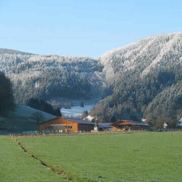
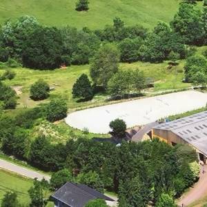
Reitanlage Erlenhof
Buchenbach
Reitanlage-Erlenhof
@Reitanlage-Erlenhof
FN-Mitglied
Freizeitstall
Vermieten
Longierzirkel/Roundpen
Paddock
Pferdezucht
24 weitere...
P
Deprecated: Creation of dynamic property Zend_View_Helper_Ads::$adLink is deprecated in /var/www/stall-frei/htdocs/staging.stall-frei.de/library/Psf/View/Helper/Ads.php on line 108

Heu und Heulage verkaufen
Mechtersen
STALL-FREIde Marketing
@STALL-FREI-Marketing
Verkaufen Sie Ihr Heu und Ihre Heulage direkt an Reiter, Pferdeställe und Reitanlagen

2 Plätze im Offenstall, mit So/Winterweide frei
Eggingen
Privat-Offenstall-Eggingen
@Privat-Offenstall-Eggingen
Freizeitstall
Geländestrecke
Krankenbox
Paddock
Notfallboxen
Außenbox mit Paddock
Offenstall
10 weitere...
P
Leider kein Vorschaubild
Leider kein Vorschaubild
Hubertushof Dressur- und Pensionsstall Aachen
Aachen
Gatzweiler
@Gatzweiler
Geländestrecke
Hunde willkommen
Laufband
Außenbox mit Paddock
Außenboxen
Vollpension
13 weitere...
B
Leider kein Vorschaubild
Leider kein Vorschaubild
Reit und Fahrstall Litjes
Weeze
Johannes-Litjes
@Johannes-Litjes
Fahrstall, Kutschwagen
Freizeitstall
Führanlage
Hunde willkommen
Gnadenbrothof
Pferdezucht
Außenbox mit Paddock
Außenboxen
23 weitere...
B

Leider kein Vorschaubild
Leider kein Vorschaubild
Schöne Paddockbox 385,00 €
Herzogenrath
Susanne Hubert
@Savelhof
Hunde willkommen
Paddock
Hufrehe geeignet
Außenbox mit Paddock
Selbstversorgung
8 weitere...
aktuell
B
Leider kein Vorschaubild
Leider kein Vorschaubild
Offenstall hat 2 Plätze frei
Herzogenrath
Private Haltergemeinschaft
@Kristina_Mazzeo
Freizeitstall
Vermieten
Krankenbox
Paddock
Offenstall
Paddock Trail
6 weitere...
B

Aufzuchtplatz / Offenstall für Hengst / Wallach
Grafenhausen-Staufen
Pondarosa-Staufen
@Pondarosa-Staufen
Fahrstall, Kutschwagen
Freizeitstall
Vermieten
Hunde willkommen
Krankenbox
Fohlenaufzucht möglich
Hengsthaltung möglich
14 weitere...
P

Frisches Stroh zu verkaufen!
Mechtersen
STALL-FREIde Marketing
@STALL-FREI-Marketing
Kaufe frisches Stroh für dein Pferd!

Zucht.- u. Ausbildungsstall Vieljahrhof
Hauset
Vieljahrhof
@Vieljahrhof
Geländestrecke
Pferdeausbildung
Vermieten
Paddock
Pensions- und Gastboxen
Pferdezucht
17 weitere...
P
❗️Ab 1. Dezember 2 freie Boxen ❗️
Rehlingen-Siersburg
Wisserhof
@Wisserhof
Freizeitstall
Geländestrecke
Vermieten
Hunde willkommen
Paddock
bedampftes/gewaschenes Heu
Fohlenaufzucht möglich
22 weitere...
P
Werde Teil von STALL-FREI.de
Du hast eine Pferdebox frei? Freie Plätze im Offenstall, Pferdestall oder der Reitanlage kostenlos anbieten.
Deprecated: Creation of dynamic property Zend_View::$pageCount is deprecated in /var/www/stall-frei/htdocs/staging.stall-frei.de/library/vendor/shardj/zf1-future/library/Zend/View/Abstract.php on line 308
Deprecated: Creation of dynamic property Zend_View::$itemCountPerPage is deprecated in /var/www/stall-frei/htdocs/staging.stall-frei.de/library/vendor/shardj/zf1-future/library/Zend/View/Abstract.php on line 308
Deprecated: Creation of dynamic property Zend_View::$first is deprecated in /var/www/stall-frei/htdocs/staging.stall-frei.de/library/vendor/shardj/zf1-future/library/Zend/View/Abstract.php on line 308
Deprecated: Creation of dynamic property Zend_View::$current is deprecated in /var/www/stall-frei/htdocs/staging.stall-frei.de/library/vendor/shardj/zf1-future/library/Zend/View/Abstract.php on line 308
Deprecated: Creation of dynamic property Zend_View::$last is deprecated in /var/www/stall-frei/htdocs/staging.stall-frei.de/library/vendor/shardj/zf1-future/library/Zend/View/Abstract.php on line 308
Deprecated: Creation of dynamic property Zend_View::$previous is deprecated in /var/www/stall-frei/htdocs/staging.stall-frei.de/library/vendor/shardj/zf1-future/library/Zend/View/Abstract.php on line 308
Deprecated: Creation of dynamic property Zend_View::$next is deprecated in /var/www/stall-frei/htdocs/staging.stall-frei.de/library/vendor/shardj/zf1-future/library/Zend/View/Abstract.php on line 308
Deprecated: Creation of dynamic property Zend_View::$pagesInRange is deprecated in /var/www/stall-frei/htdocs/staging.stall-frei.de/library/vendor/shardj/zf1-future/library/Zend/View/Abstract.php on line 308
Deprecated: Creation of dynamic property Zend_View::$firstPageInRange is deprecated in /var/www/stall-frei/htdocs/staging.stall-frei.de/library/vendor/shardj/zf1-future/library/Zend/View/Abstract.php on line 308
Deprecated: Creation of dynamic property Zend_View::$lastPageInRange is deprecated in /var/www/stall-frei/htdocs/staging.stall-frei.de/library/vendor/shardj/zf1-future/library/Zend/View/Abstract.php on line 308
Deprecated: Creation of dynamic property Zend_View::$currentItemCount is deprecated in /var/www/stall-frei/htdocs/staging.stall-frei.de/library/vendor/shardj/zf1-future/library/Zend/View/Abstract.php on line 308
Deprecated: Creation of dynamic property Zend_View::$totalItemCount is deprecated in /var/www/stall-frei/htdocs/staging.stall-frei.de/library/vendor/shardj/zf1-future/library/Zend/View/Abstract.php on line 308
Deprecated: Creation of dynamic property Zend_View::$firstItemNumber is deprecated in /var/www/stall-frei/htdocs/staging.stall-frei.de/library/vendor/shardj/zf1-future/library/Zend/View/Abstract.php on line 308
Deprecated: Creation of dynamic property Zend_View::$lastItemNumber is deprecated in /var/www/stall-frei/htdocs/staging.stall-frei.de/library/vendor/shardj/zf1-future/library/Zend/View/Abstract.php on line 308
Deprecated: Creation of dynamic property Zend_View::$router is deprecated in /var/www/stall-frei/htdocs/staging.stall-frei.de/library/vendor/shardj/zf1-future/library/Zend/View/Abstract.php on line 308
Deprecated: Creation of dynamic property Zend_View::$urlParams is deprecated in /var/www/stall-frei/htdocs/staging.stall-frei.de/library/vendor/shardj/zf1-future/library/Zend/View/Abstract.php on line 308
Deprecated: Creation of dynamic property Zend_View::$showAds is deprecated in /var/www/stall-frei/htdocs/staging.stall-frei.de/library/vendor/shardj/zf1-future/library/Zend/View/Abstract.php on line 308
Deprecated: Creation of dynamic property Zend_View::$objectIds is deprecated in /var/www/stall-frei/htdocs/staging.stall-frei.de/library/vendor/shardj/zf1-future/library/Zend/View/Abstract.php on line 308
Deprecated: Creation of dynamic property Zend_View::$showNavbar is deprecated in /var/www/stall-frei/htdocs/staging.stall-frei.de/library/vendor/shardj/zf1-future/library/Zend/View/Abstract.php on line 308
Deprecated: Creation of dynamic property Zend_View::$showBreadcrumb is deprecated in /var/www/stall-frei/htdocs/staging.stall-frei.de/library/vendor/shardj/zf1-future/library/Zend/View/Abstract.php on line 308
Deprecated: Creation of dynamic property Zend_View::$showFooter is deprecated in /var/www/stall-frei/htdocs/staging.stall-frei.de/library/vendor/shardj/zf1-future/library/Zend/View/Abstract.php on line 308
Deprecated: Creation of dynamic property Zend_View::$showInternalAds is deprecated in /var/www/stall-frei/htdocs/staging.stall-frei.de/library/vendor/shardj/zf1-future/library/Zend/View/Abstract.php on line 308
Deprecated: Creation of dynamic property Zend_View::$blNoContent is deprecated in /var/www/stall-frei/htdocs/staging.stall-frei.de/library/vendor/shardj/zf1-future/library/Zend/View/Abstract.php on line 308
Deprecated: Creation of dynamic property Zend_View::$sMetaDesc is deprecated in /var/www/stall-frei/htdocs/staging.stall-frei.de/library/vendor/shardj/zf1-future/library/Zend/View/Abstract.php on line 308
Deprecated: Creation of dynamic property Zend_View::$useGmaps is deprecated in /var/www/stall-frei/htdocs/staging.stall-frei.de/library/vendor/shardj/zf1-future/library/Zend/View/Abstract.php on line 308
Deprecated: Creation of dynamic property Zend_View::$touches is deprecated in /var/www/stall-frei/htdocs/staging.stall-frei.de/library/vendor/shardj/zf1-future/library/Zend/View/Abstract.php on line 308
Deprecated: Creation of dynamic property Zend_View::$oProject is deprecated in /var/www/stall-frei/htdocs/staging.stall-frei.de/library/vendor/shardj/zf1-future/library/Zend/View/Abstract.php on line 308
Deprecated: Creation of dynamic property Zend_View::$pageHeadline is deprecated in /var/www/stall-frei/htdocs/staging.stall-frei.de/library/vendor/shardj/zf1-future/library/Zend/View/Abstract.php on line 308
Deprecated: Creation of dynamic property Zend_View::$disableLocationField is deprecated in /var/www/stall-frei/htdocs/staging.stall-frei.de/library/vendor/shardj/zf1-future/library/Zend/View/Abstract.php on line 308
Deprecated: Creation of dynamic property Zend_View::$isSearch is deprecated in /var/www/stall-frei/htdocs/staging.stall-frei.de/library/vendor/shardj/zf1-future/library/Zend/View/Abstract.php on line 308
Deprecated: Creation of dynamic property Zend_View::$pageTitle is deprecated in /var/www/stall-frei/htdocs/staging.stall-frei.de/library/vendor/shardj/zf1-future/library/Zend/View/Abstract.php on line 308
Deprecated: Creation of dynamic property Psf_Form_Element_Text::$class is deprecated in /var/www/stall-frei/htdocs/staging.stall-frei.de/library/vendor/shardj/zf1-future/library/Zend/Form/Element.php on line 874
Deprecated: Creation of dynamic property Psf_Form_Element_Text::$size is deprecated in /var/www/stall-frei/htdocs/staging.stall-frei.de/library/vendor/shardj/zf1-future/library/Zend/Form/Element.php on line 874
Deprecated: Creation of dynamic property Psf_Form_Element_Text::$placeholder is deprecated in /var/www/stall-frei/htdocs/staging.stall-frei.de/library/vendor/shardj/zf1-future/library/Zend/Form/Element.php on line 874
Deprecated: Creation of dynamic property Psf_Form_Element_Hidden::$class is deprecated in /var/www/stall-frei/htdocs/staging.stall-frei.de/library/vendor/shardj/zf1-future/library/Zend/Form/Element.php on line 874
Deprecated: Creation of dynamic property Psf_Form_Element_Hidden::$class is deprecated in /var/www/stall-frei/htdocs/staging.stall-frei.de/library/vendor/shardj/zf1-future/library/Zend/Form/Element.php on line 874
Deprecated: Creation of dynamic property Psf_Form_Element_Hidden::$class is deprecated in /var/www/stall-frei/htdocs/staging.stall-frei.de/library/vendor/shardj/zf1-future/library/Zend/Form/Element.php on line 874
Deprecated: Creation of dynamic property Psf_Form_Element_Hidden::$class is deprecated in /var/www/stall-frei/htdocs/staging.stall-frei.de/library/vendor/shardj/zf1-future/library/Zend/Form/Element.php on line 874
Deprecated: Creation of dynamic property Psf_Form_Element_Select::$class is deprecated in /var/www/stall-frei/htdocs/staging.stall-frei.de/library/vendor/shardj/zf1-future/library/Zend/Form/Element.php on line 874
Deprecated: Creation of dynamic property Psf_Form_Element_Select::$class is deprecated in /var/www/stall-frei/htdocs/staging.stall-frei.de/library/vendor/shardj/zf1-future/library/Zend/Form/Element.php on line 874
Deprecated: Creation of dynamic property Psf_Form_Element_Select::$class is deprecated in /var/www/stall-frei/htdocs/staging.stall-frei.de/library/vendor/shardj/zf1-future/library/Zend/Form/Element.php on line 874
Deprecated: Creation of dynamic property Psf_Form_Element_Select::$class is deprecated in /var/www/stall-frei/htdocs/staging.stall-frei.de/library/vendor/shardj/zf1-future/library/Zend/Form/Element.php on line 874
Deprecated: Creation of dynamic property Psf_Form_Element_Text::$class is deprecated in /var/www/stall-frei/htdocs/staging.stall-frei.de/library/vendor/shardj/zf1-future/library/Zend/Form/Element.php on line 874
Deprecated: Creation of dynamic property Psf_Form_Element_Checkbox::$label is deprecated in /var/www/stall-frei/htdocs/staging.stall-frei.de/library/vendor/shardj/zf1-future/library/Zend/Form/Element.php on line 874
Deprecated: Creation of dynamic property Zend_View::$sort is deprecated in /var/www/stall-frei/htdocs/staging.stall-frei.de/library/vendor/shardj/zf1-future/library/Zend/View/Abstract.php on line 308
Deprecated: Creation of dynamic property Zend_View::$searchLocation is deprecated in /var/www/stall-frei/htdocs/staging.stall-frei.de/library/vendor/shardj/zf1-future/library/Zend/View/Abstract.php on line 308
Deprecated: Creation of dynamic property Zend_View::$locationHint is deprecated in /var/www/stall-frei/htdocs/staging.stall-frei.de/library/vendor/shardj/zf1-future/library/Zend/View/Abstract.php on line 308
Psf_GeoCoder_Abstract::getLocation: Frankenberg Get Location CachedOrLive
Psf_GeoCoder_Abstract::getCachedOrLive: Frankenberg
Psf_GeoCoder_Abstract::convertLocationResult
{"documentation":"https:\/\/opencagedata.com\/api","licenses":[{"name":"see attribution guide","url":"https:\/\/opencagedata.com\/credits"}],"results":[{"bounds":{"northeast":{"lat":50.9635923,"lng":13.165077},"southwest":{"lat":50.8737947,"lng":12.9883482}},"components":{"ISO_3166-1_alpha-2":"DE","ISO_3166-1_alpha-3":"DEU","ISO_3166-2":["DE-SN"],"_category":"place","_normalized_city":"Frankenberg\/Sachsen","_type":"city","continent":"Europe","country":"Deutschland","country_code":"de","county":"Mittelsachsen","political_union":"European Union","postcode":"09669","state":"Sachsen","state_code":"SN","town":"Frankenberg\/Sachsen"},"confidence":6,"formatted":"09669 Frankenberg\/Sachsen, Deutschland","geometry":{"lat":50.9110365,"lng":13.0331023}},{"bounds":{"northeast":{"lat":51.1253781,"lng":8.9262598},"southwest":{"lat":51.0181949,"lng":8.6604256}},"components":{"ISO_3166-1_alpha-2":"DE","ISO_3166-1_alpha-3":"DEU","ISO_3166-2":["DE-HE"],"_category":"place","_normalized_city":"Frankenberg (Eder)","_type":"municipality","continent":"Europe","country":"Deutschland","country_code":"de","county":"Landkreis Waldeck-Frankenberg","municipality":"Frankenberg (Eder)","political_union":"European Union","postcode":"35066","state":"Hessen","state_code":"HE"},"confidence":5,"formatted":"35066 Frankenberg (Eder), Deutschland","geometry":{"lat":51.0771933,"lng":8.7908312}},{"bounds":{"northeast":{"lat":50.1045833,"lng":11.4110932},"southwest":{"lat":50.0645833,"lng":11.3710932}},"components":{"ISO_3166-1_alpha-2":"DE","ISO_3166-1_alpha-3":"DEU","ISO_3166-2":["DE-BY"],"_category":"place","_normalized_city":"Kulmbach","_type":"village","continent":"Europe","country":"Deutschland","country_code":"de","county":"Landkreis Kulmbach","political_union":"European Union","postcode":"95336","state":"Bayern","state_code":"BY","town":"Kulmbach","village":"Frankenberg"},"confidence":7,"formatted":"95336 Frankenberg, Deutschland","geometry":{"lat":50.0845833,"lng":11.3910932}},{"bounds":{"northeast":{"lat":49.8601932,"lng":11.7519756},"southwest":{"lat":49.8201932,"lng":11.7119756}},"components":{"ISO_3166-1_alpha-2":"DE","ISO_3166-1_alpha-3":"DEU","ISO_3166-2":["DE-BY"],"_category":"place","_normalized_city":"Speichersdorf","_type":"village","continent":"Europe","country":"Deutschland","country_code":"de","county":"Landkreis Bayreuth","political_union":"European Union","postcode":"95519","state":"Bayern","state_code":"BY","town":"Speichersdorf","village":"Frankenberg"},"confidence":7,"formatted":"95519 Frankenberg, Deutschland","geometry":{"lat":49.8401932,"lng":11.7319756}},{"bounds":{"northeast":{"lat":50.0825474,"lng":11.230043},"southwest":{"lat":50.0425474,"lng":11.190043}},"components":{"ISO_3166-1_alpha-2":"DE","ISO_3166-1_alpha-3":"DEU","ISO_3166-2":["DE-BY"],"_category":"place","_normalized_city":"Weismain","_type":"hamlet","continent":"Europe","country":"Deutschland","country_code":"de","county":"Landkreis Lichtenfels","hamlet":"Frankenberg","political_union":"European Union","postcode":"96260","state":"Bayern","state_code":"BY","town":"Weismain"},"confidence":7,"formatted":"Frankenberg, 96260 Weismain, Deutschland","geometry":{"lat":50.0625474,"lng":11.210043}},{"bounds":{"northeast":{"lat":51.0920863,"lng":8.8607546},"southwest":{"lat":51.0308487,"lng":8.7553102}},"components":{"ISO_3166-1_alpha-2":"DE","ISO_3166-1_alpha-3":"DEU","ISO_3166-2":["DE-HE"],"_category":"place","_normalized_city":"Frankenberg","_type":"city","continent":"Europe","country":"Deutschland","country_code":"de","county":"Landkreis Waldeck-Frankenberg","municipality":"Frankenberg (Eder)","political_union":"European Union","postcode":"35066","state":"Hessen","state_code":"HE","town":"Frankenberg"},"confidence":7,"formatted":"35066 Frankenberg, Deutschland","geometry":{"lat":51.0554993,"lng":8.798399}},{"bounds":{"northeast":{"lat":51.8574761,"lng":10.6204501},"southwest":{"lat":51.8573761,"lng":10.6203501}},"components":{"ISO_3166-1_alpha-2":"DE","ISO_3166-1_alpha-3":"DEU","ISO_3166-2":["DE-ST"],"_category":"natural\/water","_normalized_city":"Ilsenburg","_type":"peak","continent":"Europe","country":"Deutschland","country_code":"de","county":"Landkreis Harz","peak":"Frankenberg","political_union":"European Union","state":"Sachsen-Anhalt","state_code":"ST","town":"Ilsenburg"},"confidence":9,"formatted":"Frankenberg, Ilsenburg, Sachsen-Anhalt, Deutschland","geometry":{"lat":51.8574261,"lng":10.6204001}},{"bounds":{"northeast":{"lat":51.8431345,"lng":9.0139497},"southwest":{"lat":51.8430345,"lng":9.0138497}},"components":{"ISO_3166-1_alpha-2":"DE","ISO_3166-1_alpha-3":"DEU","ISO_3166-2":["DE-NW"],"_category":"natural\/water","_normalized_city":"Steinheim","_type":"peak","continent":"Europe","country":"Deutschland","country_code":"de","county":"Kreis H\u00f6xter","peak":"Frankenberg","political_union":"European Union","state":"Nordrhein-Westfalen","state_code":"NW","town":"Steinheim"},"confidence":9,"formatted":"Frankenberg, Steinheim, Nordrhein-Westfalen, Deutschland","geometry":{"lat":51.8430845,"lng":9.0138997}},{"bounds":{"northeast":{"lat":49.2774763,"lng":8.0372933},"southwest":{"lat":49.2773763,"lng":8.0371933}},"components":{"ISO_3166-1_alpha-2":"DE","ISO_3166-1_alpha-3":"DEU","ISO_3166-2":["DE-RP"],"_category":"natural\/water","_normalized_city":"Weyher in der Pfalz","_type":"peak","continent":"Europe","country":"Deutschland","country_code":"de","county":"Landkreis S\u00fcdliche Weinstra\u00dfe","municipality":"Edenkoben","peak":"Frankenberg","political_union":"European Union","state":"Rheinland-Pfalz","state_code":"RP","village":"Weyher in der Pfalz"},"confidence":9,"formatted":"Frankenberg, Weyher in der Pfalz, Rheinland-Pfalz, Deutschland","geometry":{"lat":49.2774263,"lng":8.0372433}},{"bounds":{"northeast":{"lat":50.1722723,"lng":8.087279},"southwest":{"lat":50.1721723,"lng":8.087179}},"components":{"ISO_3166-1_alpha-2":"DE","ISO_3166-1_alpha-3":"DEU","ISO_3166-2":["DE-HE"],"_category":"natural\/water","_normalized_city":"Breithardt","_type":"peak","continent":"Europe","country":"Deutschland","country_code":"de","county":"Rheingau-Taunus-Kreis","municipality":"Hohenstein","peak":"Frankenberg","political_union":"European Union","postcode":"65329","state":"Hessen","state_code":"HE","village":"Breithardt"},"confidence":9,"formatted":"Frankenberg, 65329 Breithardt, Deutschland","geometry":{"lat":50.1722223,"lng":8.087229}}],"status":{"code":200,"message":"OK"},"stay_informed":{"blog":"https:\/\/blog.opencagedata.com","mastodon":"https:\/\/en.osm.town\/@opencage"},"thanks":"For using an OpenCage API","timestamp":{"created_http":"Sun, 08 Feb 2026 18:38:58 GMT","created_unix":1770575938},"total_results":10}Array
(
[0] => stdClass Object
(
[bounds] => stdClass Object
(
[northeast] => stdClass Object
(
[lat] => 50.9635923
[lng] => 13.165077
)
[southwest] => stdClass Object
(
[lat] => 50.8737947
[lng] => 12.9883482
)
)
[components] => stdClass Object
(
[ISO_3166-1_alpha-2] => DE
[ISO_3166-1_alpha-3] => DEU
[ISO_3166-2] => Array
(
[0] => DE-SN
)
[_category] => place
[_normalized_city] => Frankenberg/Sachsen
[_type] => city
[continent] => Europe
[country] => Deutschland
[country_code] => de
[county] => Mittelsachsen
[political_union] => European Union
[postcode] => 09669
[state] => Sachsen
[state_code] => SN
[town] => Frankenberg/Sachsen
)
[confidence] => 6
[formatted] => 09669 Frankenberg/Sachsen, Deutschland
[geometry] => stdClass Object
(
[lat] => 50.9110365
[lng] => 13.0331023
)
)
[1] => stdClass Object
(
[bounds] => stdClass Object
(
[northeast] => stdClass Object
(
[lat] => 51.1253781
[lng] => 8.9262598
)
[southwest] => stdClass Object
(
[lat] => 51.0181949
[lng] => 8.6604256
)
)
[components] => stdClass Object
(
[ISO_3166-1_alpha-2] => DE
[ISO_3166-1_alpha-3] => DEU
[ISO_3166-2] => Array
(
[0] => DE-HE
)
[_category] => place
[_normalized_city] => Frankenberg (Eder)
[_type] => municipality
[continent] => Europe
[country] => Deutschland
[country_code] => de
[county] => Landkreis Waldeck-Frankenberg
[municipality] => Frankenberg (Eder)
[political_union] => European Union
[postcode] => 35066
[state] => Hessen
[state_code] => HE
)
[confidence] => 5
[formatted] => 35066 Frankenberg (Eder), Deutschland
[geometry] => stdClass Object
(
[lat] => 51.0771933
[lng] => 8.7908312
)
)
[2] => stdClass Object
(
[bounds] => stdClass Object
(
[northeast] => stdClass Object
(
[lat] => 50.1045833
[lng] => 11.4110932
)
[southwest] => stdClass Object
(
[lat] => 50.0645833
[lng] => 11.3710932
)
)
[components] => stdClass Object
(
[ISO_3166-1_alpha-2] => DE
[ISO_3166-1_alpha-3] => DEU
[ISO_3166-2] => Array
(
[0] => DE-BY
)
[_category] => place
[_normalized_city] => Kulmbach
[_type] => village
[continent] => Europe
[country] => Deutschland
[country_code] => de
[county] => Landkreis Kulmbach
[political_union] => European Union
[postcode] => 95336
[state] => Bayern
[state_code] => BY
[town] => Kulmbach
[village] => Frankenberg
)
[confidence] => 7
[formatted] => 95336 Frankenberg, Deutschland
[geometry] => stdClass Object
(
[lat] => 50.0845833
[lng] => 11.3910932
)
)
[3] => stdClass Object
(
[bounds] => stdClass Object
(
[northeast] => stdClass Object
(
[lat] => 49.8601932
[lng] => 11.7519756
)
[southwest] => stdClass Object
(
[lat] => 49.8201932
[lng] => 11.7119756
)
)
[components] => stdClass Object
(
[ISO_3166-1_alpha-2] => DE
[ISO_3166-1_alpha-3] => DEU
[ISO_3166-2] => Array
(
[0] => DE-BY
)
[_category] => place
[_normalized_city] => Speichersdorf
[_type] => village
[continent] => Europe
[country] => Deutschland
[country_code] => de
[county] => Landkreis Bayreuth
[political_union] => European Union
[postcode] => 95519
[state] => Bayern
[state_code] => BY
[town] => Speichersdorf
[village] => Frankenberg
)
[confidence] => 7
[formatted] => 95519 Frankenberg, Deutschland
[geometry] => stdClass Object
(
[lat] => 49.8401932
[lng] => 11.7319756
)
)
[4] => stdClass Object
(
[bounds] => stdClass Object
(
[northeast] => stdClass Object
(
[lat] => 50.0825474
[lng] => 11.230043
)
[southwest] => stdClass Object
(
[lat] => 50.0425474
[lng] => 11.190043
)
)
[components] => stdClass Object
(
[ISO_3166-1_alpha-2] => DE
[ISO_3166-1_alpha-3] => DEU
[ISO_3166-2] => Array
(
[0] => DE-BY
)
[_category] => place
[_normalized_city] => Weismain
[_type] => hamlet
[continent] => Europe
[country] => Deutschland
[country_code] => de
[county] => Landkreis Lichtenfels
[hamlet] => Frankenberg
[political_union] => European Union
[postcode] => 96260
[state] => Bayern
[state_code] => BY
[town] => Weismain
)
[confidence] => 7
[formatted] => Frankenberg, 96260 Weismain, Deutschland
[geometry] => stdClass Object
(
[lat] => 50.0625474
[lng] => 11.210043
)
)
[5] => stdClass Object
(
[bounds] => stdClass Object
(
[northeast] => stdClass Object
(
[lat] => 51.0920863
[lng] => 8.8607546
)
[southwest] => stdClass Object
(
[lat] => 51.0308487
[lng] => 8.7553102
)
)
[components] => stdClass Object
(
[ISO_3166-1_alpha-2] => DE
[ISO_3166-1_alpha-3] => DEU
[ISO_3166-2] => Array
(
[0] => DE-HE
)
[_category] => place
[_normalized_city] => Frankenberg
[_type] => city
[continent] => Europe
[country] => Deutschland
[country_code] => de
[county] => Landkreis Waldeck-Frankenberg
[municipality] => Frankenberg (Eder)
[political_union] => European Union
[postcode] => 35066
[state] => Hessen
[state_code] => HE
[town] => Frankenberg
)
[confidence] => 7
[formatted] => 35066 Frankenberg, Deutschland
[geometry] => stdClass Object
(
[lat] => 51.0554993
[lng] => 8.798399
)
)
[6] => stdClass Object
(
[bounds] => stdClass Object
(
[northeast] => stdClass Object
(
[lat] => 51.8574761
[lng] => 10.6204501
)
[southwest] => stdClass Object
(
[lat] => 51.8573761
[lng] => 10.6203501
)
)
[components] => stdClass Object
(
[ISO_3166-1_alpha-2] => DE
[ISO_3166-1_alpha-3] => DEU
[ISO_3166-2] => Array
(
[0] => DE-ST
)
[_category] => natural/water
[_normalized_city] => Ilsenburg
[_type] => peak
[continent] => Europe
[country] => Deutschland
[country_code] => de
[county] => Landkreis Harz
[peak] => Frankenberg
[political_union] => European Union
[state] => Sachsen-Anhalt
[state_code] => ST
[town] => Ilsenburg
)
[confidence] => 9
[formatted] => Frankenberg, Ilsenburg, Sachsen-Anhalt, Deutschland
[geometry] => stdClass Object
(
[lat] => 51.8574261
[lng] => 10.6204001
)
)
[7] => stdClass Object
(
[bounds] => stdClass Object
(
[northeast] => stdClass Object
(
[lat] => 51.8431345
[lng] => 9.0139497
)
[southwest] => stdClass Object
(
[lat] => 51.8430345
[lng] => 9.0138497
)
)
[components] => stdClass Object
(
[ISO_3166-1_alpha-2] => DE
[ISO_3166-1_alpha-3] => DEU
[ISO_3166-2] => Array
(
[0] => DE-NW
)
[_category] => natural/water
[_normalized_city] => Steinheim
[_type] => peak
[continent] => Europe
[country] => Deutschland
[country_code] => de
[county] => Kreis Höxter
[peak] => Frankenberg
[political_union] => European Union
[state] => Nordrhein-Westfalen
[state_code] => NW
[town] => Steinheim
)
[confidence] => 9
[formatted] => Frankenberg, Steinheim, Nordrhein-Westfalen, Deutschland
[geometry] => stdClass Object
(
[lat] => 51.8430845
[lng] => 9.0138997
)
)
[8] => stdClass Object
(
[bounds] => stdClass Object
(
[northeast] => stdClass Object
(
[lat] => 49.2774763
[lng] => 8.0372933
)
[southwest] => stdClass Object
(
[lat] => 49.2773763
[lng] => 8.0371933
)
)
[components] => stdClass Object
(
[ISO_3166-1_alpha-2] => DE
[ISO_3166-1_alpha-3] => DEU
[ISO_3166-2] => Array
(
[0] => DE-RP
)
[_category] => natural/water
[_normalized_city] => Weyher in der Pfalz
[_type] => peak
[continent] => Europe
[country] => Deutschland
[country_code] => de
[county] => Landkreis Südliche Weinstraße
[municipality] => Edenkoben
[peak] => Frankenberg
[political_union] => European Union
[state] => Rheinland-Pfalz
[state_code] => RP
[village] => Weyher in der Pfalz
)
[confidence] => 9
[formatted] => Frankenberg, Weyher in der Pfalz, Rheinland-Pfalz, Deutschland
[geometry] => stdClass Object
(
[lat] => 49.2774263
[lng] => 8.0372433
)
)
[9] => stdClass Object
(
[bounds] => stdClass Object
(
[northeast] => stdClass Object
(
[lat] => 50.1722723
[lng] => 8.087279
)
[southwest] => stdClass Object
(
[lat] => 50.1721723
[lng] => 8.087179
)
)
[components] => stdClass Object
(
[ISO_3166-1_alpha-2] => DE
[ISO_3166-1_alpha-3] => DEU
[ISO_3166-2] => Array
(
[0] => DE-HE
)
[_category] => natural/water
[_normalized_city] => Breithardt
[_type] => peak
[continent] => Europe
[country] => Deutschland
[country_code] => de
[county] => Rheingau-Taunus-Kreis
[municipality] => Hohenstein
[peak] => Frankenberg
[political_union] => European Union
[postcode] => 65329
[state] => Hessen
[state_code] => HE
[village] => Breithardt
)
[confidence] => 9
[formatted] => Frankenberg, 65329 Breithardt, Deutschland
[geometry] => stdClass Object
(
[lat] => 50.1722223
[lng] => 8.087229
)
)
)
Psf_GeoCoder_OpenCageData::getKeyMap: 0
stdClass Object
(
    [bounds] => stdClass Object
        (
            [northeast] => stdClass Object
                (
                    [lat] => 50.9635923
                    [lng] => 13.165077
                )

            [southwest] => stdClass Object
                (
                    [lat] => 50.8737947
                    [lng] => 12.9883482
                )

        )

    [components] => stdClass Object
        (
            [ISO_3166-1_alpha-2] => DE
            [ISO_3166-1_alpha-3] => DEU
            [ISO_3166-2] => Array
                (
                    [0] => DE-SN
                )

            [_category] => place
            [_normalized_city] => Frankenberg/Sachsen
            [_type] => city
            [continent] => Europe
            [country] => Deutschland
            [country_code] => de
            [county] => Mittelsachsen
            [political_union] => European Union
            [postcode] => 09669
            [state] => Sachsen
            [state_code] => SN
            [town] => Frankenberg/Sachsen
        )

    [confidence] => 6
    [formatted] => 09669 Frankenberg/Sachsen, Deutschland
    [geometry] => stdClass Object
        (
            [lat] => 50.9110365
            [lng] => 13.0331023
        )

)
Psf_GeoCoder_OpenCageData::getCounty: Mittelsachsen
Psf_GeoCoder_OpenCageData::addMissingData REFETCH!
Array
(
    [address] => 09669 Frankenberg/Sachsen, Deutschland
    [type] => city
    [street] =>
    [city] => Frankenberg/Sachsen
    [county] => Mittelsachsen
    [state] => Sachsen
    [zip] => 09669
    [country] => Deutschland
    [suburb] =>
    [countrycode] => de
    [latitude] => 50.9110365
    [longitude] => 13.0331023
    [accuracy] => 1
    [confidence] => 6
    [bounds] => stdClass Object
        (
            [northeast] => stdClass Object
                (
                    [lat] => 50.9635923
                    [lng] => 13.165077
                )

            [southwest] => stdClass Object
                (
                    [lat] => 50.8737947
                    [lng] => 12.9883482
                )

        )

)
reformat!
Array
(
    [address] => 09669 Frankenberg/Sachsen, Deutschland
    [type] => city
    [street] =>
    [city] => Frankenberg/Sachsen
    [county] => Mittelsachsen
    [state] => Sachsen
    [zip] => 09669
    [country] => Deutschland
    [suburb] =>
    [countrycode] => de
    [latitude] => 50.9110365
    [longitude] => 13.0331023
    [accuracy] => 1
    [confidence] => 6
    [bounds] => stdClass Object
        (
            [northeast] => stdClass Object
                (
                    [lat] => 50.9635923
                    [lng] => 13.165077
                )

            [southwest] => stdClass Object
                (
                    [lat] => 50.8737947
                    [lng] => 12.9883482
                )

        )

    [place] => 09669 Frankenberg/Sachsen, Sachsen
    [hash] => cc565628b2b1ae47deb3fd9f0e1799ee
)
Psf_GeoCoder_OpenCageData::getKeyMap: 1
stdClass Object
(
    [bounds] => stdClass Object
        (
            [northeast] => stdClass Object
                (
                    [lat] => 51.1253781
                    [lng] => 8.9262598
                )

            [southwest] => stdClass Object
                (
                    [lat] => 51.0181949
                    [lng] => 8.6604256
                )

        )

    [components] => stdClass Object
        (
            [ISO_3166-1_alpha-2] => DE
            [ISO_3166-1_alpha-3] => DEU
            [ISO_3166-2] => Array
                (
                    [0] => DE-HE
                )

            [_category] => place
            [_normalized_city] => Frankenberg (Eder)
            [_type] => municipality
            [continent] => Europe
            [country] => Deutschland
            [country_code] => de
            [county] => Landkreis Waldeck-Frankenberg
            [municipality] => Frankenberg (Eder)
            [political_union] => European Union
            [postcode] => 35066
            [state] => Hessen
            [state_code] => HE
        )

    [confidence] => 5
    [formatted] => 35066 Frankenberg (Eder), Deutschland
    [geometry] => stdClass Object
        (
            [lat] => 51.0771933
            [lng] => 8.7908312
        )

)
Psf_GeoCoder_OpenCageData::getCounty: Waldeck-Frankenberg
Psf_GeoCoder_OpenCageData::addMissingData REFETCH!
Array
(
    [address] => 35066 Frankenberg (Eder), Deutschland
    [type] => municipality
    [street] =>
    [city] =>
    [county] => Waldeck-Frankenberg
    [state] => Hessen
    [zip] => 35066
    [country] => Deutschland
    [suburb] =>
    [countrycode] => de
    [latitude] => 51.0771933
    [longitude] => 8.7908312
    [accuracy] => 1
    [confidence] => 5
    [bounds] => stdClass Object
        (
            [northeast] => stdClass Object
                (
                    [lat] => 51.1253781
                    [lng] => 8.9262598
                )

            [southwest] => stdClass Object
                (
                    [lat] => 51.0181949
                    [lng] => 8.6604256
                )

        )

)
reformat!
Array
(
    [address] => 35066 Frankenberg (Eder), Deutschland
    [type] => municipality
    [street] =>
    [city] =>
    [county] => Waldeck-Frankenberg
    [state] => Hessen
    [zip] => 35066
    [country] => Deutschland
    [suburb] =>
    [countrycode] => de
    [latitude] => 51.0771933
    [longitude] => 8.7908312
    [accuracy] => 1
    [confidence] => 5
    [bounds] => stdClass Object
        (
            [northeast] => stdClass Object
                (
                    [lat] => 51.1253781
                    [lng] => 8.9262598
                )

            [southwest] => stdClass Object
                (
                    [lat] => 51.0181949
                    [lng] => 8.6604256
                )

        )

    [place] => 35066 , Hessen
    [hash] => 058ade1e9116f8058f33ff8b620d12db
)
Psf_GeoCoder_OpenCageData::getKeyMap: 2
stdClass Object
(
    [bounds] => stdClass Object
        (
            [northeast] => stdClass Object
                (
                    [lat] => 50.1045833
                    [lng] => 11.4110932
                )

            [southwest] => stdClass Object
                (
                    [lat] => 50.0645833
                    [lng] => 11.3710932
                )

        )

    [components] => stdClass Object
        (
            [ISO_3166-1_alpha-2] => DE
            [ISO_3166-1_alpha-3] => DEU
            [ISO_3166-2] => Array
                (
                    [0] => DE-BY
                )

            [_category] => place
            [_normalized_city] => Kulmbach
            [_type] => village
            [continent] => Europe
            [country] => Deutschland
            [country_code] => de
            [county] => Landkreis Kulmbach
            [political_union] => European Union
            [postcode] => 95336
            [state] => Bayern
            [state_code] => BY
            [town] => Kulmbach
            [village] => Frankenberg
        )

    [confidence] => 7
    [formatted] => 95336 Frankenberg, Deutschland
    [geometry] => stdClass Object
        (
            [lat] => 50.0845833
            [lng] => 11.3910932
        )

)
Psf_GeoCoder_OpenCageData::getCounty: Kulmbach
Psf_GeoCoder_OpenCageData::addMissingData REFETCH!
Array
(
    [address] => 95336 Frankenberg, Deutschland
    [type] => village
    [street] =>
    [city] => Kulmbach
    [county] => Kulmbach
    [state] => Bayern
    [zip] => 95336
    [country] => Deutschland
    [suburb] =>
    [countrycode] => de
    [latitude] => 50.0845833
    [longitude] => 11.3910932
    [accuracy] => 1
    [confidence] => 7
    [bounds] => stdClass Object
        (
            [northeast] => stdClass Object
                (
                    [lat] => 50.1045833
                    [lng] => 11.4110932
                )

            [southwest] => stdClass Object
                (
                    [lat] => 50.0645833
                    [lng] => 11.3710932
                )

        )

)
reformat!
Array
(
    [address] => 95336 Kulmbach
    [type] => village
    [street] =>
    [city] => Kulmbach
    [county] => Kulmbach
    [state] => Bayern
    [zip] => 95336
    [country] => Deutschland
    [suburb] =>
    [countrycode] => de
    [latitude] => 50.0845833
    [longitude] => 11.3910932
    [accuracy] => 1
    [confidence] => 7
    [bounds] => stdClass Object
        (
            [northeast] => stdClass Object
                (
                    [lat] => 50.1045833
                    [lng] => 11.4110932
                )

            [southwest] => stdClass Object
                (
                    [lat] => 50.0645833
                    [lng] => 11.3710932
                )

        )

    [place] => 95336 Kulmbach, Bayern
    [hash] => 9ba1d3e5ca8c52f21a8f58a408dddcc0
)
Psf_GeoCoder_OpenCageData::getKeyMap: 3
stdClass Object
(
    [bounds] => stdClass Object
        (
            [northeast] => stdClass Object
                (
                    [lat] => 49.8601932
                    [lng] => 11.7519756
                )

            [southwest] => stdClass Object
                (
                    [lat] => 49.8201932
                    [lng] => 11.7119756
                )

        )

    [components] => stdClass Object
        (
            [ISO_3166-1_alpha-2] => DE
            [ISO_3166-1_alpha-3] => DEU
            [ISO_3166-2] => Array
                (
                    [0] => DE-BY
                )

            [_category] => place
            [_normalized_city] => Speichersdorf
            [_type] => village
            [continent] => Europe
            [country] => Deutschland
            [country_code] => de
            [county] => Landkreis Bayreuth
            [political_union] => European Union
            [postcode] => 95519
            [state] => Bayern
            [state_code] => BY
            [town] => Speichersdorf
            [village] => Frankenberg
        )

    [confidence] => 7
    [formatted] => 95519 Frankenberg, Deutschland
    [geometry] => stdClass Object
        (
            [lat] => 49.8401932
            [lng] => 11.7319756
        )

)
Psf_GeoCoder_OpenCageData::getCounty: Bayreuth
Psf_GeoCoder_OpenCageData::addMissingData REFETCH!
Array
(
    [address] => 95519 Frankenberg, Deutschland
    [type] => village
    [street] =>
    [city] => Speichersdorf
    [county] => Bayreuth
    [state] => Bayern
    [zip] => 95519
    [country] => Deutschland
    [suburb] =>
    [countrycode] => de
    [latitude] => 49.8401932
    [longitude] => 11.7319756
    [accuracy] => 1
    [confidence] => 7
    [bounds] => stdClass Object
        (
            [northeast] => stdClass Object
                (
                    [lat] => 49.8601932
                    [lng] => 11.7519756
                )

            [southwest] => stdClass Object
                (
                    [lat] => 49.8201932
                    [lng] => 11.7119756
                )

        )

)
reformat!
Array
(
    [address] => 95519 Speichersdorf
    [type] => village
    [street] =>
    [city] => Speichersdorf
    [county] => Bayreuth
    [state] => Bayern
    [zip] => 95519
    [country] => Deutschland
    [suburb] =>
    [countrycode] => de
    [latitude] => 49.8401932
    [longitude] => 11.7319756
    [accuracy] => 1
    [confidence] => 7
    [bounds] => stdClass Object
        (
            [northeast] => stdClass Object
                (
                    [lat] => 49.8601932
                    [lng] => 11.7519756
                )

            [southwest] => stdClass Object
                (
                    [lat] => 49.8201932
                    [lng] => 11.7119756
                )

        )

    [place] => 95519 Speichersdorf, Bayern
    [hash] => 7cf5eb4caf4fa1495ec2bf83022a78c2
)
Psf_GeoCoder_OpenCageData::getKeyMap: 4
stdClass Object
(
    [bounds] => stdClass Object
        (
            [northeast] => stdClass Object
                (
                    [lat] => 50.0825474
                    [lng] => 11.230043
                )

            [southwest] => stdClass Object
                (
                    [lat] => 50.0425474
                    [lng] => 11.190043
                )

        )

    [components] => stdClass Object
        (
            [ISO_3166-1_alpha-2] => DE
            [ISO_3166-1_alpha-3] => DEU
            [ISO_3166-2] => Array
                (
                    [0] => DE-BY
                )

            [_category] => place
            [_normalized_city] => Weismain
            [_type] => hamlet
            [continent] => Europe
            [country] => Deutschland
            [country_code] => de
            [county] => Landkreis Lichtenfels
            [hamlet] => Frankenberg
            [political_union] => European Union
            [postcode] => 96260
            [state] => Bayern
            [state_code] => BY
            [town] => Weismain
        )

    [confidence] => 7
    [formatted] => Frankenberg, 96260 Weismain, Deutschland
    [geometry] => stdClass Object
        (
            [lat] => 50.0625474
            [lng] => 11.210043
        )

)
Psf_GeoCoder_OpenCageData::getCounty: Lichtenfels
Psf_GeoCoder_OpenCageData::addMissingData REFETCH!
Array
(
    [address] => Frankenberg, 96260 Weismain, Deutschland
    [type] => hamlet
    [street] => Frankenberg
    [city] => Weismain
    [county] => Lichtenfels
    [state] => Bayern
    [zip] => 96260
    [country] => Deutschland
    [suburb] =>
    [countrycode] => de
    [latitude] => 50.0625474
    [longitude] => 11.210043
    [accuracy] => 1
    [confidence] => 7
    [bounds] => stdClass Object
        (
            [northeast] => stdClass Object
                (
                    [lat] => 50.0825474
                    [lng] => 11.230043
                )

            [southwest] => stdClass Object
                (
                    [lat] => 50.0425474
                    [lng] => 11.190043
                )

        )

)
reformat!
Array
(
    [address] => Frankenberg, 96260 Weismain, Deutschland
    [type] => hamlet
    [street] => Frankenberg
    [city] => Weismain
    [county] => Lichtenfels
    [state] => Bayern
    [zip] => 96260
    [country] => Deutschland
    [suburb] =>
    [countrycode] => de
    [latitude] => 50.0625474
    [longitude] => 11.210043
    [accuracy] => 1
    [confidence] => 7
    [bounds] => stdClass Object
        (
            [northeast] => stdClass Object
                (
                    [lat] => 50.0825474
                    [lng] => 11.230043
                )

            [southwest] => stdClass Object
                (
                    [lat] => 50.0425474
                    [lng] => 11.190043
                )

        )

    [place] => Frankenberg, 96260 Weismain, Bayern
    [hash] => d7610eda9e2d14926f778d2837f602cd
)
Psf_GeoCoder_OpenCageData::getKeyMap: 5
stdClass Object
(
    [bounds] => stdClass Object
        (
            [northeast] => stdClass Object
                (
                    [lat] => 51.0920863
                    [lng] => 8.8607546
                )

            [southwest] => stdClass Object
                (
                    [lat] => 51.0308487
                    [lng] => 8.7553102
                )

        )

    [components] => stdClass Object
        (
            [ISO_3166-1_alpha-2] => DE
            [ISO_3166-1_alpha-3] => DEU
            [ISO_3166-2] => Array
                (
                    [0] => DE-HE
                )

            [_category] => place
            [_normalized_city] => Frankenberg
            [_type] => city
            [continent] => Europe
            [country] => Deutschland
            [country_code] => de
            [county] => Landkreis Waldeck-Frankenberg
            [municipality] => Frankenberg (Eder)
            [political_union] => European Union
            [postcode] => 35066
            [state] => Hessen
            [state_code] => HE
            [town] => Frankenberg
        )

    [confidence] => 7
    [formatted] => 35066 Frankenberg, Deutschland
    [geometry] => stdClass Object
        (
            [lat] => 51.0554993
            [lng] => 8.798399
        )

)
Psf_GeoCoder_OpenCageData::getCounty: Waldeck-Frankenberg
Psf_GeoCoder_OpenCageData::addMissingData REFETCH!
Array
(
    [address] => 35066 Frankenberg, Deutschland
    [type] => city
    [street] =>
    [city] => Frankenberg
    [county] => Waldeck-Frankenberg
    [state] => Hessen
    [zip] => 35066
    [country] => Deutschland
    [suburb] =>
    [countrycode] => de
    [latitude] => 51.0554993
    [longitude] => 8.798399
    [accuracy] => 1
    [confidence] => 7
    [bounds] => stdClass Object
        (
            [northeast] => stdClass Object
                (
                    [lat] => 51.0920863
                    [lng] => 8.8607546
                )

            [southwest] => stdClass Object
                (
                    [lat] => 51.0308487
                    [lng] => 8.7553102
                )

        )

)
reformat!
Array
(
    [address] => 35066 Frankenberg, Deutschland
    [type] => city
    [street] =>
    [city] => Frankenberg
    [county] => Waldeck-Frankenberg
    [state] => Hessen
    [zip] => 35066
    [country] => Deutschland
    [suburb] =>
    [countrycode] => de
    [latitude] => 51.0554993
    [longitude] => 8.798399
    [accuracy] => 1
    [confidence] => 7
    [bounds] => stdClass Object
        (
            [northeast] => stdClass Object
                (
                    [lat] => 51.0920863
                    [lng] => 8.8607546
                )

            [southwest] => stdClass Object
                (
                    [lat] => 51.0308487
                    [lng] => 8.7553102
                )

        )

    [place] => 35066 Frankenberg, Hessen
    [hash] => 344f2b319b2ad8771d86f62b17dfb241
)
Psf_GeoCoder_OpenCageData::getKeyMap: 6
stdClass Object
(
    [bounds] => stdClass Object
        (
            [northeast] => stdClass Object
                (
                    [lat] => 51.8574761
                    [lng] => 10.6204501
                )

            [southwest] => stdClass Object
                (
                    [lat] => 51.8573761
                    [lng] => 10.6203501
                )

        )

    [components] => stdClass Object
        (
            [ISO_3166-1_alpha-2] => DE
            [ISO_3166-1_alpha-3] => DEU
            [ISO_3166-2] => Array
                (
                    [0] => DE-ST
                )

            [_category] => natural/water
            [_normalized_city] => Ilsenburg
            [_type] => peak
            [continent] => Europe
            [country] => Deutschland
            [country_code] => de
            [county] => Landkreis Harz
            [peak] => Frankenberg
            [political_union] => European Union
            [state] => Sachsen-Anhalt
            [state_code] => ST
            [town] => Ilsenburg
        )

    [confidence] => 9
    [formatted] => Frankenberg, Ilsenburg, Sachsen-Anhalt, Deutschland
    [geometry] => stdClass Object
        (
            [lat] => 51.8574261
            [lng] => 10.6204001
        )

)
Psf_GeoCoder_OpenCageData::getCounty: Harz
Psf_GeoCoder_OpenCageData::addMissingData REFETCH!
Array
(
    [address] => Frankenberg, Ilsenburg, Sachsen-Anhalt, Deutschland
    [type] => peak
    [street] =>
    [city] => Ilsenburg
    [county] => Harz
    [state] => Sachsen-Anhalt
    [zip] =>
    [country] => Deutschland
    [suburb] =>
    [countrycode] => de
    [latitude] => 51.8574261
    [longitude] => 10.6204001
    [accuracy] => 1
    [confidence] => 9
    [bounds] => stdClass Object
        (
            [northeast] => stdClass Object
                (
                    [lat] => 51.8574761
                    [lng] => 10.6204501
                )

            [southwest] => stdClass Object
                (
                    [lat] => 51.8573761
                    [lng] => 10.6203501
                )

        )

)
reformat!
Array
(
    [address] => Frankenberg, Ilsenburg, Sachsen-Anhalt, Deutschland
    [type] => peak
    [street] =>
    [city] => Ilsenburg
    [county] => Harz
    [state] => Sachsen-Anhalt
    [zip] =>
    [country] => Deutschland
    [suburb] =>
    [countrycode] => de
    [latitude] => 51.8574261
    [longitude] => 10.6204001
    [accuracy] => 1
    [confidence] => 9
    [bounds] => stdClass Object
        (
            [northeast] => stdClass Object
                (
                    [lat] => 51.8574761
                    [lng] => 10.6204501
                )

            [southwest] => stdClass Object
                (
                    [lat] => 51.8573761
                    [lng] => 10.6203501
                )

        )

    [place] => Ilsenburg, Sachsen-Anhalt
    [hash] => 10f26e770ef1bb6ec98b8b6309b05cd6
)
Psf_GeoCoder_OpenCageData::getKeyMap: 7
stdClass Object
(
    [bounds] => stdClass Object
        (
            [northeast] => stdClass Object
                (
                    [lat] => 51.8431345
                    [lng] => 9.0139497
                )

            [southwest] => stdClass Object
                (
                    [lat] => 51.8430345
                    [lng] => 9.0138497
                )

        )

    [components] => stdClass Object
        (
            [ISO_3166-1_alpha-2] => DE
            [ISO_3166-1_alpha-3] => DEU
            [ISO_3166-2] => Array
                (
                    [0] => DE-NW
                )

            [_category] => natural/water
            [_normalized_city] => Steinheim
            [_type] => peak
            [continent] => Europe
            [country] => Deutschland
            [country_code] => de
            [county] => Kreis Höxter
            [peak] => Frankenberg
            [political_union] => European Union
            [state] => Nordrhein-Westfalen
            [state_code] => NW
            [town] => Steinheim
        )

    [confidence] => 9
    [formatted] => Frankenberg, Steinheim, Nordrhein-Westfalen, Deutschland
    [geometry] => stdClass Object
        (
            [lat] => 51.8430845
            [lng] => 9.0138997
        )

)
Psf_GeoCoder_OpenCageData::getCounty: Höxter
Psf_GeoCoder_OpenCageData::addMissingData REFETCH!
Array
(
    [address] => Frankenberg, Steinheim, Nordrhein-Westfalen, Deutschland
    [type] => peak
    [street] =>
    [city] => Steinheim
    [county] => Höxter
    [state] => Nordrhein-Westfalen
    [zip] =>
    [country] => Deutschland
    [suburb] =>
    [countrycode] => de
    [latitude] => 51.8430845
    [longitude] => 9.0138997
    [accuracy] => 1
    [confidence] => 9
    [bounds] => stdClass Object
        (
            [northeast] => stdClass Object
                (
                    [lat] => 51.8431345
                    [lng] => 9.0139497
                )

            [southwest] => stdClass Object
                (
                    [lat] => 51.8430345
                    [lng] => 9.0138497
                )

        )

)
reformat!
Array
(
    [address] => Frankenberg, Steinheim, Nordrhein-Westfalen, Deutschland
    [type] => peak
    [street] =>
    [city] => Steinheim
    [county] => Höxter
    [state] => Nordrhein-Westfalen
    [zip] =>
    [country] => Deutschland
    [suburb] =>
    [countrycode] => de
    [latitude] => 51.8430845
    [longitude] => 9.0138997
    [accuracy] => 1
    [confidence] => 9
    [bounds] => stdClass Object
        (
            [northeast] => stdClass Object
                (
                    [lat] => 51.8431345
                    [lng] => 9.0139497
                )

            [southwest] => stdClass Object
                (
                    [lat] => 51.8430345
                    [lng] => 9.0138497
                )

        )

    [place] => Steinheim, Nordrhein-Westfalen
    [hash] => 954734a732fd118ff82eab67e828e46d
)
Psf_GeoCoder_OpenCageData::getKeyMap: 8
stdClass Object
(
    [bounds] => stdClass Object
        (
            [northeast] => stdClass Object
                (
                    [lat] => 49.2774763
                    [lng] => 8.0372933
                )

            [southwest] => stdClass Object
                (
                    [lat] => 49.2773763
                    [lng] => 8.0371933
                )

        )

    [components] => stdClass Object
        (
            [ISO_3166-1_alpha-2] => DE
            [ISO_3166-1_alpha-3] => DEU
            [ISO_3166-2] => Array
                (
                    [0] => DE-RP
                )

            [_category] => natural/water
            [_normalized_city] => Weyher in der Pfalz
            [_type] => peak
            [continent] => Europe
            [country] => Deutschland
            [country_code] => de
            [county] => Landkreis Südliche Weinstraße
            [municipality] => Edenkoben
            [peak] => Frankenberg
            [political_union] => European Union
            [state] => Rheinland-Pfalz
            [state_code] => RP
            [village] => Weyher in der Pfalz
        )

    [confidence] => 9
    [formatted] => Frankenberg, Weyher in der Pfalz, Rheinland-Pfalz, Deutschland
    [geometry] => stdClass Object
        (
            [lat] => 49.2774263
            [lng] => 8.0372433
        )

)
Psf_GeoCoder_OpenCageData::getCounty: Südliche Weinstraße
Psf_GeoCoder_OpenCageData::addMissingData REFETCH!
Array
(
    [address] => Frankenberg, Weyher in der Pfalz, Rheinland-Pfalz, Deutschland
    [type] => peak
    [street] =>
    [city] => Weyher in der Pfalz
    [county] => Südliche Weinstraße
    [state] => Rheinland-Pfalz
    [zip] =>
    [country] => Deutschland
    [suburb] =>
    [countrycode] => de
    [latitude] => 49.2774263
    [longitude] => 8.0372433
    [accuracy] => 1
    [confidence] => 9
    [bounds] => stdClass Object
        (
            [northeast] => stdClass Object
                (
                    [lat] => 49.2774763
                    [lng] => 8.0372933
                )

            [southwest] => stdClass Object
                (
                    [lat] => 49.2773763
                    [lng] => 8.0371933
                )

        )

)
reformat!
Array
(
    [address] => Frankenberg, Weyher in der Pfalz, Rheinland-Pfalz, Deutschland
    [type] => peak
    [street] =>
    [city] => Weyher in der Pfalz
    [county] => Südliche Weinstraße
    [state] => Rheinland-Pfalz
    [zip] =>
    [country] => Deutschland
    [suburb] =>
    [countrycode] => de
    [latitude] => 49.2774263
    [longitude] => 8.0372433
    [accuracy] => 1
    [confidence] => 9
    [bounds] => stdClass Object
        (
            [northeast] => stdClass Object
                (
                    [lat] => 49.2774763
                    [lng] => 8.0372933
                )

            [southwest] => stdClass Object
                (
                    [lat] => 49.2773763
                    [lng] => 8.0371933
                )

        )

    [place] => Weyher in der Pfalz, Rheinland-Pfalz
    [hash] => 80e4e1665be0c30e6a23805885680021
)
Psf_GeoCoder_OpenCageData::getKeyMap: 9
stdClass Object
(
    [bounds] => stdClass Object
        (
            [northeast] => stdClass Object
                (
                    [lat] => 50.1722723
                    [lng] => 8.087279
                )

            [southwest] => stdClass Object
                (
                    [lat] => 50.1721723
                    [lng] => 8.087179
                )

        )

    [components] => stdClass Object
        (
            [ISO_3166-1_alpha-2] => DE
            [ISO_3166-1_alpha-3] => DEU
            [ISO_3166-2] => Array
                (
                    [0] => DE-HE
                )

            [_category] => natural/water
            [_normalized_city] => Breithardt
            [_type] => peak
            [continent] => Europe
            [country] => Deutschland
            [country_code] => de
            [county] => Rheingau-Taunus-Kreis
            [municipality] => Hohenstein
            [peak] => Frankenberg
            [political_union] => European Union
            [postcode] => 65329
            [state] => Hessen
            [state_code] => HE
            [village] => Breithardt
        )

    [confidence] => 9
    [formatted] => Frankenberg, 65329 Breithardt, Deutschland
    [geometry] => stdClass Object
        (
            [lat] => 50.1722223
            [lng] => 8.087229
        )

)
Psf_GeoCoder_OpenCageData::getCounty: Rheingau-Taunus-Kreis
Psf_GeoCoder_OpenCageData::addMissingData REFETCH!
Array
(
    [address] => Frankenberg, 65329 Breithardt, Deutschland
    [type] => peak
    [street] =>
    [city] => Breithardt
    [county] => Rheingau-Taunus-Kreis
    [state] => Hessen
    [zip] => 65329
    [country] => Deutschland
    [suburb] =>
    [countrycode] => de
    [latitude] => 50.1722223
    [longitude] => 8.087229
    [accuracy] => 1
    [confidence] => 9
    [bounds] => stdClass Object
        (
            [northeast] => stdClass Object
                (
                    [lat] => 50.1722723
                    [lng] => 8.087279
                )

            [southwest] => stdClass Object
                (
                    [lat] => 50.1721723
                    [lng] => 8.087179
                )

        )

)
reformat!
Array
(
    [address] => Frankenberg, 65329 Breithardt, Deutschland
    [type] => peak
    [street] =>
    [city] => Breithardt
    [county] => Rheingau-Taunus-Kreis
    [state] => Hessen
    [zip] => 65329
    [country] => Deutschland
    [suburb] =>
    [countrycode] => de
    [latitude] => 50.1722223
    [longitude] => 8.087229
    [accuracy] => 1
    [confidence] => 9
    [bounds] => stdClass Object
        (
            [northeast] => stdClass Object
                (
                    [lat] => 50.1722723
                    [lng] => 8.087279
                )

            [southwest] => stdClass Object
                (
                    [lat] => 50.1721723
                    [lng] => 8.087179
                )

        )

    [place] => 65329 Breithardt, Hessen
    [hash] => aadcd99610d31f82ca3f4513edf03125
)
Deprecated: Creation of dynamic property Zend_View::$locationHintStyle is deprecated in /var/www/stall-frei/htdocs/staging.stall-frei.de/library/vendor/shardj/zf1-future/library/Zend/View/Abstract.php on line 308
Deprecated: Creation of dynamic property Zend_View::$adGeoLocation is deprecated in /var/www/stall-frei/htdocs/staging.stall-frei.de/library/vendor/shardj/zf1-future/library/Zend/View/Abstract.php on line 308
Deprecated: Creation of dynamic property Zend_View::$recordCount is deprecated in /var/www/stall-frei/htdocs/staging.stall-frei.de/library/vendor/shardj/zf1-future/library/Zend/View/Abstract.php on line 308
Deprecated: Creation of dynamic property Zend_View::$paginationParams is deprecated in /var/www/stall-frei/htdocs/staging.stall-frei.de/library/vendor/shardj/zf1-future/library/Zend/View/Abstract.php on line 308
Deprecated: Creation of dynamic property Zend_View::$objectPaginator is deprecated in /var/www/stall-frei/htdocs/staging.stall-frei.de/library/vendor/shardj/zf1-future/library/Zend/View/Abstract.php on line 308
Deprecated: Creation of dynamic property Zend_View::$featuredObjects is deprecated in /var/www/stall-frei/htdocs/staging.stall-frei.de/library/vendor/shardj/zf1-future/library/Zend/View/Abstract.php on line 308
Deprecated: Creation of dynamic property Zend_View::$hints is deprecated in /var/www/stall-frei/htdocs/staging.stall-frei.de/library/vendor/shardj/zf1-future/library/Zend/View/Abstract.php on line 308
Deprecated: Creation of dynamic property Zend_View::$attributeHints is deprecated in /var/www/stall-frei/htdocs/staging.stall-frei.de/library/vendor/shardj/zf1-future/library/Zend/View/Abstract.php on line 308
Deprecated: Creation of dynamic property Zend_View::$oSearchForm is deprecated in /var/www/stall-frei/htdocs/staging.stall-frei.de/library/vendor/shardj/zf1-future/library/Zend/View/Abstract.php on line 308