Deprecated: Creation of dynamic property Zend_View::$sMode is deprecated in /var/www/stall-frei/htdocs/staging.stall-frei.de/library/vendor/shardj/zf1-future/library/Zend/View/Abstract.php on line 308
Stallplatz oder Offenstall in Merseburg
Gesucht wird in "Dom zu Merseburg, Domplatz 7, 06217 Merseburg, Deutschland"
6.328 Einträge
Deprecated: Creation of dynamic property Zend_View::$listObjects is deprecated in /var/www/stall-frei/htdocs/staging.stall-frei.de/library/vendor/shardj/zf1-future/library/Zend/View/Abstract.php on line 308
Gesponsort


Deprecated: Creation of dynamic property Zend_View::$listMode is deprecated in /var/www/stall-frei/htdocs/staging.stall-frei.de/library/vendor/shardj/zf1-future/library/Zend/View/Abstract.php on line 308
Deprecated: Creation of dynamic property Zend_View::$renderedObjects is deprecated in /var/www/stall-frei/htdocs/staging.stall-frei.de/library/vendor/shardj/zf1-future/library/Zend/View/Abstract.php on line 308
Deprecated: Creation of dynamic property Zend_View::$index is deprecated in /var/www/stall-frei/htdocs/staging.stall-frei.de/library/vendor/shardj/zf1-future/library/Zend/View/Abstract.php on line 308
Deprecated: Creation of dynamic property Zend_View::$displayMode is deprecated in /var/www/stall-frei/htdocs/staging.stall-frei.de/library/vendor/shardj/zf1-future/library/Zend/View/Abstract.php on line 308
Deprecated: Creation of dynamic property Zend_View::$remarketingIds is deprecated in /var/www/stall-frei/htdocs/staging.stall-frei.de/library/vendor/shardj/zf1-future/library/Zend/View/Abstract.php on line 308
Deprecated: Creation of dynamic property Zend_View::$listItem is deprecated in /var/www/stall-frei/htdocs/staging.stall-frei.de/library/vendor/shardj/zf1-future/library/Zend/View/Abstract.php on line 308
Deprecated: Creation of dynamic property Zend_View::$object is deprecated in /var/www/stall-frei/htdocs/staging.stall-frei.de/library/vendor/shardj/zf1-future/library/Zend/View/Abstract.php on line 308
Deprecated: Creation of dynamic property Zend_View::$attributes is deprecated in /var/www/stall-frei/htdocs/staging.stall-frei.de/library/vendor/shardj/zf1-future/library/Zend/View/Abstract.php on line 308
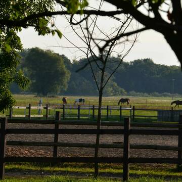
Reitstall in den traumhaften Saaleauen in Holleben
Holleben
Burghof-Holleben-UG-Co-KG
@Burghof-Holleben-UG-Co-KG
FN-Mitglied
Freizeitstall
Paddock
Reithalle
Innenbox
Vollpension
7 weitere...
aktuell
S
Deprecated: Creation of dynamic property Zend_View_Helper_Ads::$adLink is deprecated in /var/www/stall-frei/htdocs/staging.stall-frei.de/library/Psf/View/Helper/Ads.php on line 108

Heu aus neuer Ernte
Mechtersen
STALL-FREIde Marketing
@STALL-FREI-Marketing
Heulage und Pferdeheu aus der neuen Ernte findest du in unserem Futtermarkt
Leider kein Vorschaubild
Leider kein Vorschaubild
Offenstall Plätze
Weißenfels
Sigrun Fröhlich
@Equiemption
Freizeitstall
Pferdeausbildung
Vermieten
Hunde willkommen
Paddock
Allergikerstall
Fohlenaufzucht möglich
17 weitere...
aktuell
B
Leider kein Vorschaubild
Leider kein Vorschaubild
Reha-Boxen
Weißenfels
Sigrun Fröhlich
@Equiemption
Freizeitstall
Pferdeausbildung
Vermieten
Hunde willkommen
Longierzirkel/Roundpen
Allergikerstall
Fohlenaufzucht möglich
22 weitere...
B
Leider kein Vorschaubild
Leider kein Vorschaubild
Selbstversorgerbox
Weißenfels
Sigrun Fröhlich
@Equiemption
Vermieten
Hunde willkommen
Parkplatz für Pferdeanhänger
Allergikerstall
Hufrehe geeignet
Offenstall
8 weitere...
B
Leider kein Vorschaubild
Leider kein Vorschaubild
Aufzuchtsplätze
Weißenfels
Sigrun Fröhlich
@Equiemption
Freizeitstall
Reitlehrer und -unterricht
Vermieten
Hunde willkommen
Pensions- und Gastboxen
Allergikerstall
Fohlenaufzucht möglich
13 weitere...
B
Leider kein Vorschaubild
Leider kein Vorschaubild
Pferdeboxen frei
Weißenfels
Sigrun Fröhlich
@Equiemption
Freizeitstall
Pferdeausbildung
Vermieten
Hunde willkommen
Longierzirkel/Roundpen
Allergikerstall
bedampftes/gewaschenes Heu
21 weitere...
B

Frisches Stroh zu verkaufen!
Mechtersen
STALL-FREIde Marketing
@STALL-FREI-Marketing
Kaufe frisches Stroh für dein Pferd!

Freie Pferdeboxen auf dem Reiterhof Bienitzblick
Schkeuditz/ Dölzig
Reiterhof Bienitzblick Dölzig
@Reiterhof-Bienitzblick
Freizeitstall
Longierzirkel/Roundpen
Pensions- und Gastboxen
Außenbox mit Paddock
Außenboxen
Vollpension
7 weitere...
P

Reiterhof Kleinliebenau GmbH
Schkeuditz OT Kleinliebenau
Reiterhof-Kleinliebenau-GmbH
@Reiterhof-Kleinliebenau-GmbH
Freizeitstall
Vermieten
Hunde willkommen
Krankenbox
Außenbox mit Paddock
Innenbox
16 weitere...
P
Leider kein Vorschaubild
Leider kein Vorschaubild
Für Pferd & Mensch Natur pur
Braunsbedra, Sachsen-Anhalt
RFFB e.V.
@Braunsbedra
Freizeitstall
Krankenbox
Longierzirkel/Roundpen
Halbpension
Einzelne Boxen oder Stallplätze
10 weitere...
B
Leider kein Vorschaubild
Leider kein Vorschaubild
im schönen Geiseltal
Braunsbedra, Sachsen-Anhalt
RFFB e.V.
@Braunsbedra
Freizeitstall
Krankenbox
Longierzirkel/Roundpen
Vollpension
Einzelne Boxen oder Stallplätze
9 weitere...
aktuell
B
Deprecated: Creation of dynamic property Zend_View::$pageCount is deprecated in /var/www/stall-frei/htdocs/staging.stall-frei.de/library/vendor/shardj/zf1-future/library/Zend/View/Abstract.php on line 308
Deprecated: Creation of dynamic property Zend_View::$itemCountPerPage is deprecated in /var/www/stall-frei/htdocs/staging.stall-frei.de/library/vendor/shardj/zf1-future/library/Zend/View/Abstract.php on line 308
Deprecated: Creation of dynamic property Zend_View::$first is deprecated in /var/www/stall-frei/htdocs/staging.stall-frei.de/library/vendor/shardj/zf1-future/library/Zend/View/Abstract.php on line 308
Deprecated: Creation of dynamic property Zend_View::$current is deprecated in /var/www/stall-frei/htdocs/staging.stall-frei.de/library/vendor/shardj/zf1-future/library/Zend/View/Abstract.php on line 308
Deprecated: Creation of dynamic property Zend_View::$last is deprecated in /var/www/stall-frei/htdocs/staging.stall-frei.de/library/vendor/shardj/zf1-future/library/Zend/View/Abstract.php on line 308
Deprecated: Creation of dynamic property Zend_View::$next is deprecated in /var/www/stall-frei/htdocs/staging.stall-frei.de/library/vendor/shardj/zf1-future/library/Zend/View/Abstract.php on line 308
Deprecated: Creation of dynamic property Zend_View::$pagesInRange is deprecated in /var/www/stall-frei/htdocs/staging.stall-frei.de/library/vendor/shardj/zf1-future/library/Zend/View/Abstract.php on line 308
Deprecated: Creation of dynamic property Zend_View::$firstPageInRange is deprecated in /var/www/stall-frei/htdocs/staging.stall-frei.de/library/vendor/shardj/zf1-future/library/Zend/View/Abstract.php on line 308
Deprecated: Creation of dynamic property Zend_View::$lastPageInRange is deprecated in /var/www/stall-frei/htdocs/staging.stall-frei.de/library/vendor/shardj/zf1-future/library/Zend/View/Abstract.php on line 308
Deprecated: Creation of dynamic property Zend_View::$currentItemCount is deprecated in /var/www/stall-frei/htdocs/staging.stall-frei.de/library/vendor/shardj/zf1-future/library/Zend/View/Abstract.php on line 308
Deprecated: Creation of dynamic property Zend_View::$totalItemCount is deprecated in /var/www/stall-frei/htdocs/staging.stall-frei.de/library/vendor/shardj/zf1-future/library/Zend/View/Abstract.php on line 308
Deprecated: Creation of dynamic property Zend_View::$firstItemNumber is deprecated in /var/www/stall-frei/htdocs/staging.stall-frei.de/library/vendor/shardj/zf1-future/library/Zend/View/Abstract.php on line 308
Deprecated: Creation of dynamic property Zend_View::$lastItemNumber is deprecated in /var/www/stall-frei/htdocs/staging.stall-frei.de/library/vendor/shardj/zf1-future/library/Zend/View/Abstract.php on line 308
Deprecated: Creation of dynamic property Zend_View::$router is deprecated in /var/www/stall-frei/htdocs/staging.stall-frei.de/library/vendor/shardj/zf1-future/library/Zend/View/Abstract.php on line 308
Deprecated: Creation of dynamic property Zend_View::$urlParams is deprecated in /var/www/stall-frei/htdocs/staging.stall-frei.de/library/vendor/shardj/zf1-future/library/Zend/View/Abstract.php on line 308
Deprecated: Creation of dynamic property Zend_View::$showAds is deprecated in /var/www/stall-frei/htdocs/staging.stall-frei.de/library/vendor/shardj/zf1-future/library/Zend/View/Abstract.php on line 308
Deprecated: Creation of dynamic property Zend_View::$objectIds is deprecated in /var/www/stall-frei/htdocs/staging.stall-frei.de/library/vendor/shardj/zf1-future/library/Zend/View/Abstract.php on line 308
Deprecated: Creation of dynamic property Zend_View::$showNavbar is deprecated in /var/www/stall-frei/htdocs/staging.stall-frei.de/library/vendor/shardj/zf1-future/library/Zend/View/Abstract.php on line 308
Deprecated: Creation of dynamic property Zend_View::$showBreadcrumb is deprecated in /var/www/stall-frei/htdocs/staging.stall-frei.de/library/vendor/shardj/zf1-future/library/Zend/View/Abstract.php on line 308
Deprecated: Creation of dynamic property Zend_View::$showFooter is deprecated in /var/www/stall-frei/htdocs/staging.stall-frei.de/library/vendor/shardj/zf1-future/library/Zend/View/Abstract.php on line 308
Deprecated: Creation of dynamic property Zend_View::$showInternalAds is deprecated in /var/www/stall-frei/htdocs/staging.stall-frei.de/library/vendor/shardj/zf1-future/library/Zend/View/Abstract.php on line 308
Deprecated: Creation of dynamic property Zend_View::$blNoContent is deprecated in /var/www/stall-frei/htdocs/staging.stall-frei.de/library/vendor/shardj/zf1-future/library/Zend/View/Abstract.php on line 308
Deprecated: Creation of dynamic property Zend_View::$sMetaDesc is deprecated in /var/www/stall-frei/htdocs/staging.stall-frei.de/library/vendor/shardj/zf1-future/library/Zend/View/Abstract.php on line 308
Deprecated: Creation of dynamic property Zend_View::$useGmaps is deprecated in /var/www/stall-frei/htdocs/staging.stall-frei.de/library/vendor/shardj/zf1-future/library/Zend/View/Abstract.php on line 308
Deprecated: Creation of dynamic property Zend_View::$touches is deprecated in /var/www/stall-frei/htdocs/staging.stall-frei.de/library/vendor/shardj/zf1-future/library/Zend/View/Abstract.php on line 308
Deprecated: Creation of dynamic property Zend_View::$oProject is deprecated in /var/www/stall-frei/htdocs/staging.stall-frei.de/library/vendor/shardj/zf1-future/library/Zend/View/Abstract.php on line 308
Deprecated: Creation of dynamic property Zend_View::$pageHeadline is deprecated in /var/www/stall-frei/htdocs/staging.stall-frei.de/library/vendor/shardj/zf1-future/library/Zend/View/Abstract.php on line 308
Deprecated: Creation of dynamic property Zend_View::$disableLocationField is deprecated in /var/www/stall-frei/htdocs/staging.stall-frei.de/library/vendor/shardj/zf1-future/library/Zend/View/Abstract.php on line 308
Deprecated: Creation of dynamic property Zend_View::$isSearch is deprecated in /var/www/stall-frei/htdocs/staging.stall-frei.de/library/vendor/shardj/zf1-future/library/Zend/View/Abstract.php on line 308
Deprecated: Creation of dynamic property Zend_View::$pageTitle is deprecated in /var/www/stall-frei/htdocs/staging.stall-frei.de/library/vendor/shardj/zf1-future/library/Zend/View/Abstract.php on line 308
Deprecated: Creation of dynamic property Psf_Form_Element_Text::$class is deprecated in /var/www/stall-frei/htdocs/staging.stall-frei.de/library/vendor/shardj/zf1-future/library/Zend/Form/Element.php on line 874
Deprecated: Creation of dynamic property Psf_Form_Element_Text::$size is deprecated in /var/www/stall-frei/htdocs/staging.stall-frei.de/library/vendor/shardj/zf1-future/library/Zend/Form/Element.php on line 874
Deprecated: Creation of dynamic property Psf_Form_Element_Text::$placeholder is deprecated in /var/www/stall-frei/htdocs/staging.stall-frei.de/library/vendor/shardj/zf1-future/library/Zend/Form/Element.php on line 874
Deprecated: Creation of dynamic property Psf_Form_Element_Hidden::$class is deprecated in /var/www/stall-frei/htdocs/staging.stall-frei.de/library/vendor/shardj/zf1-future/library/Zend/Form/Element.php on line 874
Deprecated: Creation of dynamic property Psf_Form_Element_Hidden::$class is deprecated in /var/www/stall-frei/htdocs/staging.stall-frei.de/library/vendor/shardj/zf1-future/library/Zend/Form/Element.php on line 874
Deprecated: Creation of dynamic property Psf_Form_Element_Hidden::$class is deprecated in /var/www/stall-frei/htdocs/staging.stall-frei.de/library/vendor/shardj/zf1-future/library/Zend/Form/Element.php on line 874
Deprecated: Creation of dynamic property Psf_Form_Element_Hidden::$class is deprecated in /var/www/stall-frei/htdocs/staging.stall-frei.de/library/vendor/shardj/zf1-future/library/Zend/Form/Element.php on line 874
Deprecated: Creation of dynamic property Psf_Form_Element_Select::$class is deprecated in /var/www/stall-frei/htdocs/staging.stall-frei.de/library/vendor/shardj/zf1-future/library/Zend/Form/Element.php on line 874
Deprecated: Creation of dynamic property Psf_Form_Element_Select::$class is deprecated in /var/www/stall-frei/htdocs/staging.stall-frei.de/library/vendor/shardj/zf1-future/library/Zend/Form/Element.php on line 874
Deprecated: Creation of dynamic property Psf_Form_Element_Select::$class is deprecated in /var/www/stall-frei/htdocs/staging.stall-frei.de/library/vendor/shardj/zf1-future/library/Zend/Form/Element.php on line 874
Deprecated: Creation of dynamic property Psf_Form_Element_Select::$class is deprecated in /var/www/stall-frei/htdocs/staging.stall-frei.de/library/vendor/shardj/zf1-future/library/Zend/Form/Element.php on line 874
Deprecated: Creation of dynamic property Psf_Form_Element_Text::$class is deprecated in /var/www/stall-frei/htdocs/staging.stall-frei.de/library/vendor/shardj/zf1-future/library/Zend/Form/Element.php on line 874
Deprecated: Creation of dynamic property Psf_Form_Element_Checkbox::$label is deprecated in /var/www/stall-frei/htdocs/staging.stall-frei.de/library/vendor/shardj/zf1-future/library/Zend/Form/Element.php on line 874
Deprecated: Creation of dynamic property Zend_View::$sort is deprecated in /var/www/stall-frei/htdocs/staging.stall-frei.de/library/vendor/shardj/zf1-future/library/Zend/View/Abstract.php on line 308
Deprecated: Creation of dynamic property Zend_View::$searchLocation is deprecated in /var/www/stall-frei/htdocs/staging.stall-frei.de/library/vendor/shardj/zf1-future/library/Zend/View/Abstract.php on line 308
Deprecated: Creation of dynamic property Zend_View::$locationHint is deprecated in /var/www/stall-frei/htdocs/staging.stall-frei.de/library/vendor/shardj/zf1-future/library/Zend/View/Abstract.php on line 308
Psf_GeoCoder_Abstract::getLocation: Saint-Jean Get Location CachedOrLive
Psf_GeoCoder_Abstract::getCachedOrLive: Saint-Jean
Psf_GeoCoder_OpenCageData::makeApiRequest: response:
Array
(
[documentation] => https://opencagedata.com/api
[licenses] => Array
(
[0] => Array
(
[name] => see attribution guide
[url] => https://opencagedata.com/credits
)
)
[results] => Array
(
[0] => Array
(
[bounds] => Array
(
[northeast] => Array
(
[lat] => 51.3587846
[lng] => 12.0016192
)
[southwest] => Array
(
[lat] => 51.3584058
[lng] => 12.0005561
)
)
[components] => Array
(
[ISO_3166-1_alpha-2] => DE
[ISO_3166-1_alpha-3] => DEU
[ISO_3166-2] => Array
(
[0] => DE-ST
)
[_category] => place_of_worship
[_normalized_city] => Merseburg
[_type] => cathedral
[cathedral] => Dom zu Merseburg
[city_district] => Merseburg
[continent] => Europe
[country] => Deutschland
[country_code] => de
[county] => Saalekreis
[house_number] => 7
[political_union] => European Union
[postcode] => 06217
[road] => Domplatz
[state] => Sachsen-Anhalt
[state_code] => ST
[suburb] => Altenburg (Vorstadt)
[town] => Merseburg
)
[confidence] => 9
[formatted] => Dom zu Merseburg, Domplatz 7, 06217 Merseburg, Deutschland
[geometry] => Array
(
[lat] => 51.3585968
[lng] => 12.0010781
)
)
[1] => Array
(
[bounds] => Array
(
[northeast] => Array
(
[lat] => 53.2480906
[lng] => 10.4133945
)
[southwest] => Array
(
[lat] => 53.2475621
[lng] => 10.4123184
)
)
[components] => Array
(
[ISO_3166-1_alpha-2] => DE
[ISO_3166-1_alpha-3] => DEU
[ISO_3166-2] => Array
(
[0] => DE-NI
)
[_category] => place_of_worship
[_normalized_city] => Lüneburg
[_type] => church
[church] => St. Johannis
[continent] => Europe
[country] => Deutschland
[country_code] => de
[county] => Landkreis Lüneburg
[house_number] => 2
[political_union] => European Union
[postcode] => 21335
[road] => Bei der St. Johanniskirche
[state] => Niedersachsen
[state_code] => NI
[suburb] => Altstadt
[town] => Lüneburg
)
[confidence] => 9
[formatted] => St. Johannis, Bei der St. Johanniskirche 2, 21335 Lüneburg, Deutschland
[geometry] => Array
(
[lat] => 53.2478304
[lng] => 10.4128456
)
)
[2] => Array
(
[bounds] => Array
(
[northeast] => Array
(
[lat] => 53.7040639
[lng] => 10.7754546
)
[southwest] => Array
(
[lat] => 53.7037042
[lng] => 10.7744209
)
)
[components] => Array
(
[ISO_3166-1_alpha-2] => DE
[ISO_3166-1_alpha-3] => DEU
[ISO_3166-2] => Array
(
[0] => DE-SH
)
[_category] => place_of_worship
[_normalized_city] => Ratzeburg
[_type] => place_of_worship
[continent] => Europe
[country] => Deutschland
[country_code] => de
[county] => Kreis Herzogtum Lauenburg
[house_number] => 35
[place_of_worship] => Ratzeburger Dom
[political_union] => European Union
[postcode] => 23909
[road] => Domhof
[state] => Schleswig-Holstein
[state_code] => SH
[suburb] => Inselstadt
[town] => Ratzeburg
)
[confidence] => 9
[formatted] => Ratzeburger Dom, Domhof 35, 23909 Ratzeburg, Deutschland
[geometry] => Array
(
[lat] => 53.7038826
[lng] => 10.7749501
)
)
[3] => Array
(
[bounds] => Array
(
[northeast] => Array
(
[lat] => 49.2332559
[lng] => 6.9985828
)
[southwest] => Array
(
[lat] => 49.2328553
[lng] => 6.998005
)
)
[components] => Array
(
[ISO_3166-1_alpha-2] => DE
[ISO_3166-1_alpha-3] => DEU
[ISO_3166-2] => Array
(
[0] => DE-SL
)
[_category] => place_of_worship
[_normalized_city] => Saarbrücken
[_type] => place_of_worship
[borough] => Bezirk Mitte
[city] => Saarbrücken
[continent] => Europe
[country] => Deutschland
[country_code] => de
[county] => Regionalverband Saarbrücken
[house_number] => 26
[neighbourhood] => St. Johanner Markt
[place_of_worship] => Basilika St. Johann
[political_union] => European Union
[postcode] => 66111
[road] => Katholisch-Kirch-Straße
[state] => Saarland
[state_code] => SL
[suburb] => St. Johann
)
[confidence] => 9
[formatted] => Basilika St. Johann, Katholisch-Kirch-Straße 26, 66111 Saarbrücken, Deutschland
[geometry] => Array
(
[lat] => 49.2330815
[lng] => 6.9983331
)
)
[4] => Array
(
[bounds] => Array
(
[northeast] => Array
(
[lat] => 49.9986023
[lng] => 8.2727461
)
[southwest] => Array
(
[lat] => 49.9982288
[lng] => 8.2720193
)
)
[components] => Array
(
[ISO_3166-1_alpha-2] => DE
[ISO_3166-1_alpha-3] => DEU
[ISO_3166-2] => Array
(
[0] => DE-RP
)
[_category] => place_of_worship
[_normalized_city] => Mainz
[_type] => place_of_worship
[city] => Mainz
[continent] => Europe
[country] => Deutschland
[country_code] => de
[place_of_worship] => Sankt Johannis
[political_union] => European Union
[postcode] => 55116
[quarter] => Südliche Altstadt
[road] => Schöfferstraße
[state] => Rheinland-Pfalz
[state_code] => RP
[suburb] => Altstadt
)
[confidence] => 9
[formatted] => Sankt Johannis, Schöfferstraße, 55116 Mainz, Deutschland
[geometry] => Array
(
[lat] => 49.998412
[lng] => 8.272387
)
)
[5] => Array
(
[bounds] => Array
(
[northeast] => Array
(
[lat] => 49.2360838
[lng] => 6.9971005
)
[southwest] => Array
(
[lat] => 49.235695
[lng] => 6.9964596
)
)
[components] => Array
(
[ISO_3166-1_alpha-2] => DE
[ISO_3166-1_alpha-3] => DEU
[ISO_3166-2] => Array
(
[0] => DE-SL
)
[_category] => place_of_worship
[_normalized_city] => Saarbrücken
[_type] => place_of_worship
[borough] => Bezirk Mitte
[city] => Saarbrücken
[continent] => Europe
[country] => Deutschland
[country_code] => de
[county] => Regionalverband Saarbrücken
[house_number] => 2
[neighbourhood] => Nauwieser Viertel
[place_of_worship] => Johanneskirche
[political_union] => European Union
[postcode] => 66111
[road] => Cecilienstraße
[state] => Saarland
[state_code] => SL
[suburb] => St. Johann
)
[confidence] => 9
[formatted] => Johanneskirche, Cecilienstraße 2, 66111 Saarbrücken, Deutschland
[geometry] => Array
(
[lat] => 49.2358807
[lng] => 6.9968342
)
)
[6] => Array
(
[bounds] => Array
(
[northeast] => Array
(
[lat] => 49.2296958
[lng] => 9.2178154
)
[southwest] => Array
(
[lat] => 49.229449
[lng] => 9.2170779
)
)
[components] => Array
(
[ISO_3166-1_alpha-2] => DE
[ISO_3166-1_alpha-3] => DEU
[ISO_3166-2] => Array
(
[0] => DE-BW
)
[_category] => road
[_normalized_city] => Bad Friedrichshall
[_type] => road
[city] => Bad Friedrichshall
[continent] => Europe
[country] => Deutschland
[country_code] => de
[county] => Landkreis Heilbronn
[municipality] => VVG der Stadt Bad Friedrichshall
[political_union] => European Union
[postcode] => 74177
[road] => Saint-Jean-Le-Blanc-Straße
[road_type] => residential
[state] => Baden-Württemberg
[state_code] => BW
[suburb] => Kochendorf
[town] => Friedrichshall
)
[confidence] => 9
[formatted] => Saint-Jean-Le-Blanc-Straße, 74177 Friedrichshall, Deutschland
[geometry] => Array
(
[lat] => 49.2295029
[lng] => 9.2174285
)
)
[7] => Array
(
[bounds] => Array
(
[northeast] => Array
(
[lat] => 49.2391022
[lng] => 6.979544
)
[southwest] => Array
(
[lat] => 49.2388715
[lng] => 6.9781821
)
)
[components] => Array
(
[ISO_3166-1_alpha-2] => DE
[ISO_3166-1_alpha-3] => DEU
[ISO_3166-2] => Array
(
[0] => DE-SL
)
[_category] => road
[_normalized_city] => Saarbrücken
[_type] => road
[borough] => Bezirk Mitte
[city] => Saarbrücken
[continent] => Europe
[country] => Deutschland
[country_code] => de
[county] => Regionalverband Saarbrücken
[political_union] => European Union
[postcode] => 66115
[road] => St. Johanner Straße
[road_type] => primary
[state] => Saarland
[state_code] => SL
[suburb] => Malstatt
)
[confidence] => 9
[formatted] => St. Johanner Straße, 66115 Saarbrücken, Deutschland
[geometry] => Array
(
[lat] => 49.2389577
[lng] => 6.9788673
)
)
[8] => Array
(
[components] => Array
(
[ISO_3166-1_alpha-2] => FR
[ISO_3166-1_alpha-3] => FRA
[ISO_3166-2] => Array
(
[0] => FR-BRE
[1] => FR-29
)
[_category] => road
[_normalized_city] => Leuhan
[_type] => road
[city] => Leuhan
[continent] => Europe
[country] => France
[country_code] => fr
[county] => Finistère
[local_authority] => Communauté de communes de Haute-Cornouaille
[political_union] => European Union
[postcode] => 29390
[road] => Saint-Jean
[state] => Bretagne
[state_code] => BRE
)
[confidence] => 4
[formatted] => Saint-Jean, 29390 Leuhan, France
[geometry] => Array
(
[lat] => 48.086953
[lng] => -3.775851
)
)
[9] => Array
(
[components] => Array
(
[ISO_3166-1_alpha-2] => FR
[ISO_3166-1_alpha-3] => FRA
[ISO_3166-2] => Array
(
[0] => FR-PAC
[1] => FR-83
)
[_category] => place
[_normalized_city] => Flayosc
[_type] => place
[city] => Flayosc
[continent] => Europe
[country] => France
[country_code] => fr
[county] => Var
[local_authority] => Dracénie Provence Verdon agglomération
[place] => Saint Jean
[political_union] => European Union
[postcode] => 83780
[state] => Provence-Alpes-Côte d'Azur
[state_code] => PAC
)
[confidence] => 4
[formatted] => Saint Jean, 83780 Flayosc, France
[geometry] => Array
(
[lat] => 43.524345
[lng] => 6.406791
)
)
)
[status] => Array
(
[code] => 200
[message] => OK
)
[stay_informed] => Array
(
[blog] => https://blog.opencagedata.com
[mastodon] => https://en.osm.town/@opencage
)
[thanks] => For using an OpenCage API
[timestamp] => Array
(
[created_http] => Sun, 08 Feb 2026 09:54:52 GMT
[created_unix] => 1770544492
)
[total_results] => 10
)
Psf_GeoCoder_Abstract::convertLocationResult
{"documentation":"https:\/\/opencagedata.com\/api","licenses":[{"name":"see attribution guide","url":"https:\/\/opencagedata.com\/credits"}],"results":[{"bounds":{"northeast":{"lat":51.3587846,"lng":12.0016192},"southwest":{"lat":51.3584058,"lng":12.0005561}},"components":{"ISO_3166-1_alpha-2":"DE","ISO_3166-1_alpha-3":"DEU","ISO_3166-2":["DE-ST"],"_category":"place_of_worship","_normalized_city":"Merseburg","_type":"cathedral","cathedral":"Dom zu Merseburg","city_district":"Merseburg","continent":"Europe","country":"Deutschland","country_code":"de","county":"Saalekreis","house_number":"7","political_union":"European Union","postcode":"06217","road":"Domplatz","state":"Sachsen-Anhalt","state_code":"ST","suburb":"Altenburg (Vorstadt)","town":"Merseburg"},"confidence":9,"formatted":"Dom zu Merseburg, Domplatz 7, 06217 Merseburg, Deutschland","geometry":{"lat":51.3585968,"lng":12.0010781}},{"bounds":{"northeast":{"lat":53.2480906,"lng":10.4133945},"southwest":{"lat":53.2475621,"lng":10.4123184}},"components":{"ISO_3166-1_alpha-2":"DE","ISO_3166-1_alpha-3":"DEU","ISO_3166-2":["DE-NI"],"_category":"place_of_worship","_normalized_city":"L\u00fcneburg","_type":"church","church":"St. Johannis","continent":"Europe","country":"Deutschland","country_code":"de","county":"Landkreis L\u00fcneburg","house_number":"2","political_union":"European Union","postcode":"21335","road":"Bei der St. Johanniskirche","state":"Niedersachsen","state_code":"NI","suburb":"Altstadt","town":"L\u00fcneburg"},"confidence":9,"formatted":"St. Johannis, Bei der St. Johanniskirche 2, 21335 L\u00fcneburg, Deutschland","geometry":{"lat":53.2478304,"lng":10.4128456}},{"bounds":{"northeast":{"lat":53.7040639,"lng":10.7754546},"southwest":{"lat":53.7037042,"lng":10.7744209}},"components":{"ISO_3166-1_alpha-2":"DE","ISO_3166-1_alpha-3":"DEU","ISO_3166-2":["DE-SH"],"_category":"place_of_worship","_normalized_city":"Ratzeburg","_type":"place_of_worship","continent":"Europe","country":"Deutschland","country_code":"de","county":"Kreis Herzogtum Lauenburg","house_number":"35","place_of_worship":"Ratzeburger Dom","political_union":"European Union","postcode":"23909","road":"Domhof","state":"Schleswig-Holstein","state_code":"SH","suburb":"Inselstadt","town":"Ratzeburg"},"confidence":9,"formatted":"Ratzeburger Dom, Domhof 35, 23909 Ratzeburg, Deutschland","geometry":{"lat":53.7038826,"lng":10.7749501}},{"bounds":{"northeast":{"lat":49.2332559,"lng":6.9985828},"southwest":{"lat":49.2328553,"lng":6.998005}},"components":{"ISO_3166-1_alpha-2":"DE","ISO_3166-1_alpha-3":"DEU","ISO_3166-2":["DE-SL"],"_category":"place_of_worship","_normalized_city":"Saarbr\u00fccken","_type":"place_of_worship","borough":"Bezirk Mitte","city":"Saarbr\u00fccken","continent":"Europe","country":"Deutschland","country_code":"de","county":"Regionalverband Saarbr\u00fccken","house_number":"26","neighbourhood":"St. Johanner Markt","place_of_worship":"Basilika St. Johann","political_union":"European Union","postcode":"66111","road":"Katholisch-Kirch-Stra\u00dfe","state":"Saarland","state_code":"SL","suburb":"St. Johann"},"confidence":9,"formatted":"Basilika St. Johann, Katholisch-Kirch-Stra\u00dfe 26, 66111 Saarbr\u00fccken, Deutschland","geometry":{"lat":49.2330815,"lng":6.9983331}},{"bounds":{"northeast":{"lat":49.9986023,"lng":8.2727461},"southwest":{"lat":49.9982288,"lng":8.2720193}},"components":{"ISO_3166-1_alpha-2":"DE","ISO_3166-1_alpha-3":"DEU","ISO_3166-2":["DE-RP"],"_category":"place_of_worship","_normalized_city":"Mainz","_type":"place_of_worship","city":"Mainz","continent":"Europe","country":"Deutschland","country_code":"de","place_of_worship":"Sankt Johannis","political_union":"European Union","postcode":"55116","quarter":"S\u00fcdliche Altstadt","road":"Sch\u00f6fferstra\u00dfe","state":"Rheinland-Pfalz","state_code":"RP","suburb":"Altstadt"},"confidence":9,"formatted":"Sankt Johannis, Sch\u00f6fferstra\u00dfe, 55116 Mainz, Deutschland","geometry":{"lat":49.998412,"lng":8.272387}},{"bounds":{"northeast":{"lat":49.2360838,"lng":6.9971005},"southwest":{"lat":49.235695,"lng":6.9964596}},"components":{"ISO_3166-1_alpha-2":"DE","ISO_3166-1_alpha-3":"DEU","ISO_3166-2":["DE-SL"],"_category":"place_of_worship","_normalized_city":"Saarbr\u00fccken","_type":"place_of_worship","borough":"Bezirk Mitte","city":"Saarbr\u00fccken","continent":"Europe","country":"Deutschland","country_code":"de","county":"Regionalverband Saarbr\u00fccken","house_number":"2","neighbourhood":"Nauwieser Viertel","place_of_worship":"Johanneskirche","political_union":"European Union","postcode":"66111","road":"Cecilienstra\u00dfe","state":"Saarland","state_code":"SL","suburb":"St. Johann"},"confidence":9,"formatted":"Johanneskirche, Cecilienstra\u00dfe 2, 66111 Saarbr\u00fccken, Deutschland","geometry":{"lat":49.2358807,"lng":6.9968342}},{"bounds":{"northeast":{"lat":49.2296958,"lng":9.2178154},"southwest":{"lat":49.229449,"lng":9.2170779}},"components":{"ISO_3166-1_alpha-2":"DE","ISO_3166-1_alpha-3":"DEU","ISO_3166-2":["DE-BW"],"_category":"road","_normalized_city":"Bad Friedrichshall","_type":"road","city":"Bad Friedrichshall","continent":"Europe","country":"Deutschland","country_code":"de","county":"Landkreis Heilbronn","municipality":"VVG der Stadt Bad Friedrichshall","political_union":"European Union","postcode":"74177","road":"Saint-Jean-Le-Blanc-Stra\u00dfe","road_type":"residential","state":"Baden-W\u00fcrttemberg","state_code":"BW","suburb":"Kochendorf","town":"Friedrichshall"},"confidence":9,"formatted":"Saint-Jean-Le-Blanc-Stra\u00dfe, 74177 Friedrichshall, Deutschland","geometry":{"lat":49.2295029,"lng":9.2174285}},{"bounds":{"northeast":{"lat":49.2391022,"lng":6.979544},"southwest":{"lat":49.2388715,"lng":6.9781821}},"components":{"ISO_3166-1_alpha-2":"DE","ISO_3166-1_alpha-3":"DEU","ISO_3166-2":["DE-SL"],"_category":"road","_normalized_city":"Saarbr\u00fccken","_type":"road","borough":"Bezirk Mitte","city":"Saarbr\u00fccken","continent":"Europe","country":"Deutschland","country_code":"de","county":"Regionalverband Saarbr\u00fccken","political_union":"European Union","postcode":"66115","road":"St. Johanner Stra\u00dfe","road_type":"primary","state":"Saarland","state_code":"SL","suburb":"Malstatt"},"confidence":9,"formatted":"St. Johanner Stra\u00dfe, 66115 Saarbr\u00fccken, Deutschland","geometry":{"lat":49.2389577,"lng":6.9788673}},{"components":{"ISO_3166-1_alpha-2":"FR","ISO_3166-1_alpha-3":"FRA","ISO_3166-2":["FR-BRE","FR-29"],"_category":"road","_normalized_city":"Leuhan","_type":"road","city":"Leuhan","continent":"Europe","country":"France","country_code":"fr","county":"Finist\u00e8re","local_authority":"Communaut\u00e9 de communes de Haute-Cornouaille","political_union":"European Union","postcode":"29390","road":"Saint-Jean","state":"Bretagne","state_code":"BRE"},"confidence":4,"formatted":"Saint-Jean, 29390 Leuhan, France","geometry":{"lat":48.086953,"lng":-3.775851}},{"components":{"ISO_3166-1_alpha-2":"FR","ISO_3166-1_alpha-3":"FRA","ISO_3166-2":["FR-PAC","FR-83"],"_category":"place","_normalized_city":"Flayosc","_type":"place","city":"Flayosc","continent":"Europe","country":"France","country_code":"fr","county":"Var","local_authority":"Drac\u00e9nie Provence Verdon agglom\u00e9ration","place":"Saint Jean","political_union":"European Union","postcode":"83780","state":"Provence-Alpes-C\u00f4te d'Azur","state_code":"PAC"},"confidence":4,"formatted":"Saint Jean, 83780 Flayosc, France","geometry":{"lat":43.524345,"lng":6.406791}}],"status":{"code":200,"message":"OK"},"stay_informed":{"blog":"https:\/\/blog.opencagedata.com","mastodon":"https:\/\/en.osm.town\/@opencage"},"thanks":"For using an OpenCage API","timestamp":{"created_http":"Sun, 08 Feb 2026 09:54:52 GMT","created_unix":1770544492},"total_results":10}Array
(
[0] => stdClass Object
(
[bounds] => stdClass Object
(
[northeast] => stdClass Object
(
[lat] => 51.3587846
[lng] => 12.0016192
)
[southwest] => stdClass Object
(
[lat] => 51.3584058
[lng] => 12.0005561
)
)
[components] => stdClass Object
(
[ISO_3166-1_alpha-2] => DE
[ISO_3166-1_alpha-3] => DEU
[ISO_3166-2] => Array
(
[0] => DE-ST
)
[_category] => place_of_worship
[_normalized_city] => Merseburg
[_type] => cathedral
[cathedral] => Dom zu Merseburg
[city_district] => Merseburg
[continent] => Europe
[country] => Deutschland
[country_code] => de
[county] => Saalekreis
[house_number] => 7
[political_union] => European Union
[postcode] => 06217
[road] => Domplatz
[state] => Sachsen-Anhalt
[state_code] => ST
[suburb] => Altenburg (Vorstadt)
[town] => Merseburg
)
[confidence] => 9
[formatted] => Dom zu Merseburg, Domplatz 7, 06217 Merseburg, Deutschland
[geometry] => stdClass Object
(
[lat] => 51.3585968
[lng] => 12.0010781
)
)
[1] => stdClass Object
(
[bounds] => stdClass Object
(
[northeast] => stdClass Object
(
[lat] => 53.2480906
[lng] => 10.4133945
)
[southwest] => stdClass Object
(
[lat] => 53.2475621
[lng] => 10.4123184
)
)
[components] => stdClass Object
(
[ISO_3166-1_alpha-2] => DE
[ISO_3166-1_alpha-3] => DEU
[ISO_3166-2] => Array
(
[0] => DE-NI
)
[_category] => place_of_worship
[_normalized_city] => Lüneburg
[_type] => church
[church] => St. Johannis
[continent] => Europe
[country] => Deutschland
[country_code] => de
[county] => Landkreis Lüneburg
[house_number] => 2
[political_union] => European Union
[postcode] => 21335
[road] => Bei der St. Johanniskirche
[state] => Niedersachsen
[state_code] => NI
[suburb] => Altstadt
[town] => Lüneburg
)
[confidence] => 9
[formatted] => St. Johannis, Bei der St. Johanniskirche 2, 21335 Lüneburg, Deutschland
[geometry] => stdClass Object
(
[lat] => 53.2478304
[lng] => 10.4128456
)
)
[2] => stdClass Object
(
[bounds] => stdClass Object
(
[northeast] => stdClass Object
(
[lat] => 53.7040639
[lng] => 10.7754546
)
[southwest] => stdClass Object
(
[lat] => 53.7037042
[lng] => 10.7744209
)
)
[components] => stdClass Object
(
[ISO_3166-1_alpha-2] => DE
[ISO_3166-1_alpha-3] => DEU
[ISO_3166-2] => Array
(
[0] => DE-SH
)
[_category] => place_of_worship
[_normalized_city] => Ratzeburg
[_type] => place_of_worship
[continent] => Europe
[country] => Deutschland
[country_code] => de
[county] => Kreis Herzogtum Lauenburg
[house_number] => 35
[place_of_worship] => Ratzeburger Dom
[political_union] => European Union
[postcode] => 23909
[road] => Domhof
[state] => Schleswig-Holstein
[state_code] => SH
[suburb] => Inselstadt
[town] => Ratzeburg
)
[confidence] => 9
[formatted] => Ratzeburger Dom, Domhof 35, 23909 Ratzeburg, Deutschland
[geometry] => stdClass Object
(
[lat] => 53.7038826
[lng] => 10.7749501
)
)
[3] => stdClass Object
(
[bounds] => stdClass Object
(
[northeast] => stdClass Object
(
[lat] => 49.2332559
[lng] => 6.9985828
)
[southwest] => stdClass Object
(
[lat] => 49.2328553
[lng] => 6.998005
)
)
[components] => stdClass Object
(
[ISO_3166-1_alpha-2] => DE
[ISO_3166-1_alpha-3] => DEU
[ISO_3166-2] => Array
(
[0] => DE-SL
)
[_category] => place_of_worship
[_normalized_city] => Saarbrücken
[_type] => place_of_worship
[borough] => Bezirk Mitte
[city] => Saarbrücken
[continent] => Europe
[country] => Deutschland
[country_code] => de
[county] => Regionalverband Saarbrücken
[house_number] => 26
[neighbourhood] => St. Johanner Markt
[place_of_worship] => Basilika St. Johann
[political_union] => European Union
[postcode] => 66111
[road] => Katholisch-Kirch-Straße
[state] => Saarland
[state_code] => SL
[suburb] => St. Johann
)
[confidence] => 9
[formatted] => Basilika St. Johann, Katholisch-Kirch-Straße 26, 66111 Saarbrücken, Deutschland
[geometry] => stdClass Object
(
[lat] => 49.2330815
[lng] => 6.9983331
)
)
[4] => stdClass Object
(
[bounds] => stdClass Object
(
[northeast] => stdClass Object
(
[lat] => 49.9986023
[lng] => 8.2727461
)
[southwest] => stdClass Object
(
[lat] => 49.9982288
[lng] => 8.2720193
)
)
[components] => stdClass Object
(
[ISO_3166-1_alpha-2] => DE
[ISO_3166-1_alpha-3] => DEU
[ISO_3166-2] => Array
(
[0] => DE-RP
)
[_category] => place_of_worship
[_normalized_city] => Mainz
[_type] => place_of_worship
[city] => Mainz
[continent] => Europe
[country] => Deutschland
[country_code] => de
[place_of_worship] => Sankt Johannis
[political_union] => European Union
[postcode] => 55116
[quarter] => Südliche Altstadt
[road] => Schöfferstraße
[state] => Rheinland-Pfalz
[state_code] => RP
[suburb] => Altstadt
)
[confidence] => 9
[formatted] => Sankt Johannis, Schöfferstraße, 55116 Mainz, Deutschland
[geometry] => stdClass Object
(
[lat] => 49.998412
[lng] => 8.272387
)
)
[5] => stdClass Object
(
[bounds] => stdClass Object
(
[northeast] => stdClass Object
(
[lat] => 49.2360838
[lng] => 6.9971005
)
[southwest] => stdClass Object
(
[lat] => 49.235695
[lng] => 6.9964596
)
)
[components] => stdClass Object
(
[ISO_3166-1_alpha-2] => DE
[ISO_3166-1_alpha-3] => DEU
[ISO_3166-2] => Array
(
[0] => DE-SL
)
[_category] => place_of_worship
[_normalized_city] => Saarbrücken
[_type] => place_of_worship
[borough] => Bezirk Mitte
[city] => Saarbrücken
[continent] => Europe
[country] => Deutschland
[country_code] => de
[county] => Regionalverband Saarbrücken
[house_number] => 2
[neighbourhood] => Nauwieser Viertel
[place_of_worship] => Johanneskirche
[political_union] => European Union
[postcode] => 66111
[road] => Cecilienstraße
[state] => Saarland
[state_code] => SL
[suburb] => St. Johann
)
[confidence] => 9
[formatted] => Johanneskirche, Cecilienstraße 2, 66111 Saarbrücken, Deutschland
[geometry] => stdClass Object
(
[lat] => 49.2358807
[lng] => 6.9968342
)
)
[6] => stdClass Object
(
[bounds] => stdClass Object
(
[northeast] => stdClass Object
(
[lat] => 49.2296958
[lng] => 9.2178154
)
[southwest] => stdClass Object
(
[lat] => 49.229449
[lng] => 9.2170779
)
)
[components] => stdClass Object
(
[ISO_3166-1_alpha-2] => DE
[ISO_3166-1_alpha-3] => DEU
[ISO_3166-2] => Array
(
[0] => DE-BW
)
[_category] => road
[_normalized_city] => Bad Friedrichshall
[_type] => road
[city] => Bad Friedrichshall
[continent] => Europe
[country] => Deutschland
[country_code] => de
[county] => Landkreis Heilbronn
[municipality] => VVG der Stadt Bad Friedrichshall
[political_union] => European Union
[postcode] => 74177
[road] => Saint-Jean-Le-Blanc-Straße
[road_type] => residential
[state] => Baden-Württemberg
[state_code] => BW
[suburb] => Kochendorf
[town] => Friedrichshall
)
[confidence] => 9
[formatted] => Saint-Jean-Le-Blanc-Straße, 74177 Friedrichshall, Deutschland
[geometry] => stdClass Object
(
[lat] => 49.2295029
[lng] => 9.2174285
)
)
[7] => stdClass Object
(
[bounds] => stdClass Object
(
[northeast] => stdClass Object
(
[lat] => 49.2391022
[lng] => 6.979544
)
[southwest] => stdClass Object
(
[lat] => 49.2388715
[lng] => 6.9781821
)
)
[components] => stdClass Object
(
[ISO_3166-1_alpha-2] => DE
[ISO_3166-1_alpha-3] => DEU
[ISO_3166-2] => Array
(
[0] => DE-SL
)
[_category] => road
[_normalized_city] => Saarbrücken
[_type] => road
[borough] => Bezirk Mitte
[city] => Saarbrücken
[continent] => Europe
[country] => Deutschland
[country_code] => de
[county] => Regionalverband Saarbrücken
[political_union] => European Union
[postcode] => 66115
[road] => St. Johanner Straße
[road_type] => primary
[state] => Saarland
[state_code] => SL
[suburb] => Malstatt
)
[confidence] => 9
[formatted] => St. Johanner Straße, 66115 Saarbrücken, Deutschland
[geometry] => stdClass Object
(
[lat] => 49.2389577
[lng] => 6.9788673
)
)
[8] => stdClass Object
(
[components] => stdClass Object
(
[ISO_3166-1_alpha-2] => FR
[ISO_3166-1_alpha-3] => FRA
[ISO_3166-2] => Array
(
[0] => FR-BRE
[1] => FR-29
)
[_category] => road
[_normalized_city] => Leuhan
[_type] => road
[city] => Leuhan
[continent] => Europe
[country] => France
[country_code] => fr
[county] => Finistère
[local_authority] => Communauté de communes de Haute-Cornouaille
[political_union] => European Union
[postcode] => 29390
[road] => Saint-Jean
[state] => Bretagne
[state_code] => BRE
)
[confidence] => 4
[formatted] => Saint-Jean, 29390 Leuhan, France
[geometry] => stdClass Object
(
[lat] => 48.086953
[lng] => -3.775851
)
)
[9] => stdClass Object
(
[components] => stdClass Object
(
[ISO_3166-1_alpha-2] => FR
[ISO_3166-1_alpha-3] => FRA
[ISO_3166-2] => Array
(
[0] => FR-PAC
[1] => FR-83
)
[_category] => place
[_normalized_city] => Flayosc
[_type] => place
[city] => Flayosc
[continent] => Europe
[country] => France
[country_code] => fr
[county] => Var
[local_authority] => Dracénie Provence Verdon agglomération
[place] => Saint Jean
[political_union] => European Union
[postcode] => 83780
[state] => Provence-Alpes-Côte d'Azur
[state_code] => PAC
)
[confidence] => 4
[formatted] => Saint Jean, 83780 Flayosc, France
[geometry] => stdClass Object
(
[lat] => 43.524345
[lng] => 6.406791
)
)
)
Psf_GeoCoder_OpenCageData::getKeyMap: 0
stdClass Object
(
    [bounds] => stdClass Object
        (
            [northeast] => stdClass Object
                (
                    [lat] => 51.3587846
                    [lng] => 12.0016192
                )

            [southwest] => stdClass Object
                (
                    [lat] => 51.3584058
                    [lng] => 12.0005561
                )

        )

    [components] => stdClass Object
        (
            [ISO_3166-1_alpha-2] => DE
            [ISO_3166-1_alpha-3] => DEU
            [ISO_3166-2] => Array
                (
                    [0] => DE-ST
                )

            [_category] => place_of_worship
            [_normalized_city] => Merseburg
            [_type] => cathedral
            [cathedral] => Dom zu Merseburg
            [city_district] => Merseburg
            [continent] => Europe
            [country] => Deutschland
            [country_code] => de
            [county] => Saalekreis
            [house_number] => 7
            [political_union] => European Union
            [postcode] => 06217
            [road] => Domplatz
            [state] => Sachsen-Anhalt
            [state_code] => ST
            [suburb] => Altenburg (Vorstadt)
            [town] => Merseburg
        )

    [confidence] => 9
    [formatted] => Dom zu Merseburg, Domplatz 7, 06217 Merseburg, Deutschland
    [geometry] => stdClass Object
        (
            [lat] => 51.3585968
            [lng] => 12.0010781
        )

)
Psf_GeoCoder_OpenCageData::getCounty: Saalekreis
Psf_GeoCoder_OpenCageData::addMissingData REFETCH!
Array
(
    [address] => Dom zu Merseburg, Domplatz 7, 06217 Merseburg, Deutschland
    [type] => cathedral
    [street] => Domplatz 7
    [city] => Merseburg
    [county] => Saalekreis
    [state] => Sachsen-Anhalt
    [zip] => 06217
    [country] => Deutschland
    [suburb] => Altenburg (Vorstadt)
    [countrycode] => de
    [latitude] => 51.3585968
    [longitude] => 12.0010781
    [accuracy] => 1
    [confidence] => 9
    [bounds] => stdClass Object
        (
            [northeast] => stdClass Object
                (
                    [lat] => 51.3587846
                    [lng] => 12.0016192
                )

            [southwest] => stdClass Object
                (
                    [lat] => 51.3584058
                    [lng] => 12.0005561
                )

        )

)
reformat!
Array
(
    [address] => Dom zu Merseburg, Domplatz 7, 06217 Merseburg, Deutschland
    [type] => cathedral
    [street] => Domplatz 7
    [city] => Merseburg
    [county] => Saalekreis
    [state] => Sachsen-Anhalt
    [zip] => 06217
    [country] => Deutschland
    [suburb] => Altenburg (Vorstadt)
    [countrycode] => de
    [latitude] => 51.3585968
    [longitude] => 12.0010781
    [accuracy] => 1
    [confidence] => 9
    [bounds] => stdClass Object
        (
            [northeast] => stdClass Object
                (
                    [lat] => 51.3587846
                    [lng] => 12.0016192
                )

            [southwest] => stdClass Object
                (
                    [lat] => 51.3584058
                    [lng] => 12.0005561
                )

        )

    [place] => Domplatz 7, 06217 Merseburg, Sachsen-Anhalt
    [hash] => 689b464c787f32263d64cc1ebd9f38f0
)
Psf_GeoCoder_OpenCageData::getKeyMap: 1
stdClass Object
(
    [bounds] => stdClass Object
        (
            [northeast] => stdClass Object
                (
                    [lat] => 53.2480906
                    [lng] => 10.4133945
                )

            [southwest] => stdClass Object
                (
                    [lat] => 53.2475621
                    [lng] => 10.4123184
                )

        )

    [components] => stdClass Object
        (
            [ISO_3166-1_alpha-2] => DE
            [ISO_3166-1_alpha-3] => DEU
            [ISO_3166-2] => Array
                (
                    [0] => DE-NI
                )

            [_category] => place_of_worship
            [_normalized_city] => Lüneburg
            [_type] => church
            [church] => St. Johannis
            [continent] => Europe
            [country] => Deutschland
            [country_code] => de
            [county] => Landkreis Lüneburg
            [house_number] => 2
            [political_union] => European Union
            [postcode] => 21335
            [road] => Bei der St. Johanniskirche
            [state] => Niedersachsen
            [state_code] => NI
            [suburb] => Altstadt
            [town] => Lüneburg
        )

    [confidence] => 9
    [formatted] => St. Johannis, Bei der St. Johanniskirche 2, 21335 Lüneburg, Deutschland
    [geometry] => stdClass Object
        (
            [lat] => 53.2478304
            [lng] => 10.4128456
        )

)
Psf_GeoCoder_OpenCageData::getCounty: Lüneburg
Psf_GeoCoder_OpenCageData::addMissingData REFETCH!
Array
(
    [address] => St. Johannis, Bei der St. Johanniskirche 2, 21335 Lüneburg, Deutschland
    [type] => church
    [street] => Bei der St. Johanniskirche 2
    [city] => Lüneburg
    [county] => Lüneburg
    [state] => Niedersachsen
    [zip] => 21335
    [country] => Deutschland
    [suburb] => Altstadt
    [countrycode] => de
    [latitude] => 53.2478304
    [longitude] => 10.4128456
    [accuracy] => 1
    [confidence] => 9
    [bounds] => stdClass Object
        (
            [northeast] => stdClass Object
                (
                    [lat] => 53.2480906
                    [lng] => 10.4133945
                )

            [southwest] => stdClass Object
                (
                    [lat] => 53.2475621
                    [lng] => 10.4123184
                )

        )

)
reformat!
Array
(
    [address] => St. Johannis, Bei der St. Johanniskirche 2, 21335 Lüneburg, Deutschland
    [type] => church
    [street] => Bei der St. Johanniskirche 2
    [city] => Lüneburg
    [county] => Lüneburg
    [state] => Niedersachsen
    [zip] => 21335
    [country] => Deutschland
    [suburb] => Altstadt
    [countrycode] => de
    [latitude] => 53.2478304
    [longitude] => 10.4128456
    [accuracy] => 1
    [confidence] => 9
    [bounds] => stdClass Object
        (
            [northeast] => stdClass Object
                (
                    [lat] => 53.2480906
                    [lng] => 10.4133945
                )

            [southwest] => stdClass Object
                (
                    [lat] => 53.2475621
                    [lng] => 10.4123184
                )

        )

    [place] => Bei der St. Johanniskirche 2, 21335 Lüneburg, Niedersachsen
    [hash] => c6f8591505c8755342e24b234b5653d4
)
Psf_GeoCoder_OpenCageData::getKeyMap: 2
stdClass Object
(
    [bounds] => stdClass Object
        (
            [northeast] => stdClass Object
                (
                    [lat] => 53.7040639
                    [lng] => 10.7754546
                )

            [southwest] => stdClass Object
                (
                    [lat] => 53.7037042
                    [lng] => 10.7744209
                )

        )

    [components] => stdClass Object
        (
            [ISO_3166-1_alpha-2] => DE
            [ISO_3166-1_alpha-3] => DEU
            [ISO_3166-2] => Array
                (
                    [0] => DE-SH
                )

            [_category] => place_of_worship
            [_normalized_city] => Ratzeburg
            [_type] => place_of_worship
            [continent] => Europe
            [country] => Deutschland
            [country_code] => de
            [county] => Kreis Herzogtum Lauenburg
            [house_number] => 35
            [place_of_worship] => Ratzeburger Dom
            [political_union] => European Union
            [postcode] => 23909
            [road] => Domhof
            [state] => Schleswig-Holstein
            [state_code] => SH
            [suburb] => Inselstadt
            [town] => Ratzeburg
        )

    [confidence] => 9
    [formatted] => Ratzeburger Dom, Domhof 35, 23909 Ratzeburg, Deutschland
    [geometry] => stdClass Object
        (
            [lat] => 53.7038826
            [lng] => 10.7749501
        )

)
Psf_GeoCoder_OpenCageData::getCounty: Herzogtum Lauenburg
Psf_GeoCoder_OpenCageData::addMissingData REFETCH!
Array
(
    [address] => Ratzeburger Dom, Domhof 35, 23909 Ratzeburg, Deutschland
    [type] => place_of_worship
    [street] => Domhof 35
    [city] => Ratzeburg
    [county] => Herzogtum Lauenburg
    [state] => Schleswig-Holstein
    [zip] => 23909
    [country] => Deutschland
    [suburb] => Inselstadt
    [countrycode] => de
    [latitude] => 53.7038826
    [longitude] => 10.7749501
    [accuracy] => 1
    [confidence] => 9
    [bounds] => stdClass Object
        (
            [northeast] => stdClass Object
                (
                    [lat] => 53.7040639
                    [lng] => 10.7754546
                )

            [southwest] => stdClass Object
                (
                    [lat] => 53.7037042
                    [lng] => 10.7744209
                )

        )

)
reformat!
Array
(
    [address] => Ratzeburger Dom, Domhof 35, 23909 Ratzeburg, Deutschland
    [type] => place_of_worship
    [street] => Domhof 35
    [city] => Ratzeburg
    [county] => Herzogtum Lauenburg
    [state] => Schleswig-Holstein
    [zip] => 23909
    [country] => Deutschland
    [suburb] => Inselstadt
    [countrycode] => de
    [latitude] => 53.7038826
    [longitude] => 10.7749501
    [accuracy] => 1
    [confidence] => 9
    [bounds] => stdClass Object
        (
            [northeast] => stdClass Object
                (
                    [lat] => 53.7040639
                    [lng] => 10.7754546
                )

            [southwest] => stdClass Object
                (
                    [lat] => 53.7037042
                    [lng] => 10.7744209
                )

        )

    [place] => Domhof 35, 23909 Ratzeburg, Schleswig-Holstein
    [hash] => 18bf838b9f332edeefb2bdf3c59c40ca
)
Psf_GeoCoder_OpenCageData::getKeyMap: 3
stdClass Object
(
    [bounds] => stdClass Object
        (
            [northeast] => stdClass Object
                (
                    [lat] => 49.2332559
                    [lng] => 6.9985828
                )

            [southwest] => stdClass Object
                (
                    [lat] => 49.2328553
                    [lng] => 6.998005
                )

        )

    [components] => stdClass Object
        (
            [ISO_3166-1_alpha-2] => DE
            [ISO_3166-1_alpha-3] => DEU
            [ISO_3166-2] => Array
                (
                    [0] => DE-SL
                )

            [_category] => place_of_worship
            [_normalized_city] => Saarbrücken
            [_type] => place_of_worship
            [borough] => Bezirk Mitte
            [city] => Saarbrücken
            [continent] => Europe
            [country] => Deutschland
            [country_code] => de
            [county] => Regionalverband Saarbrücken
            [house_number] => 26
            [neighbourhood] => St. Johanner Markt
            [place_of_worship] => Basilika St. Johann
            [political_union] => European Union
            [postcode] => 66111
            [road] => Katholisch-Kirch-Straße
            [state] => Saarland
            [state_code] => SL
            [suburb] => St. Johann
        )

    [confidence] => 9
    [formatted] => Basilika St. Johann, Katholisch-Kirch-Straße 26, 66111 Saarbrücken, Deutschland
    [geometry] => stdClass Object
        (
            [lat] => 49.2330815
            [lng] => 6.9983331
        )

)
Psf_GeoCoder_OpenCageData::getCounty: alverband Saarbrücken
Psf_GeoCoder_OpenCageData::addMissingData REFETCH!
Array
(
    [address] => Basilika St. Johann, Katholisch-Kirch-Straße 26, 66111 Saarbrücken, Deutschland
    [type] => place_of_worship
    [street] => Katholisch-Kirch-Straße 26
    [city] => St. Johann
    [county] => alverband Saarbrücken
    [state] => Saarland
    [zip] => 66111
    [country] => Deutschland
    [suburb] => St. Johann
    [countrycode] => de
    [latitude] => 49.2330815
    [longitude] => 6.9983331
    [accuracy] => 1
    [confidence] => 9
    [bounds] => stdClass Object
        (
            [northeast] => stdClass Object
                (
                    [lat] => 49.2332559
                    [lng] => 6.9985828
                )

            [southwest] => stdClass Object
                (
                    [lat] => 49.2328553
                    [lng] => 6.998005
                )

        )

)
reformat!
Array
(
    [address] => Basilika St. Johann, Katholisch-Kirch-Straße 26, 66111 Saarbrücken, Deutschland
    [type] => place_of_worship
    [street] => Katholisch-Kirch-Straße 26
    [city] => St. Johann
    [county] => alverband Saarbrücken
    [state] => Saarland
    [zip] => 66111
    [country] => Deutschland
    [suburb] => St. Johann
    [countrycode] => de
    [latitude] => 49.2330815
    [longitude] => 6.9983331
    [accuracy] => 1
    [confidence] => 9
    [bounds] => stdClass Object
        (
            [northeast] => stdClass Object
                (
                    [lat] => 49.2332559
                    [lng] => 6.9985828
                )

            [southwest] => stdClass Object
                (
                    [lat] => 49.2328553
                    [lng] => 6.998005
                )

        )

    [place] => Katholisch-Kirch-Straße 26, 66111 St. Johann, Saarland
    [hash] => f145da62a64115b4255cb51c2468a9c3
)
Psf_GeoCoder_OpenCageData::getKeyMap: 4
stdClass Object
(
    [bounds] => stdClass Object
        (
            [northeast] => stdClass Object
                (
                    [lat] => 49.9986023
                    [lng] => 8.2727461
                )

            [southwest] => stdClass Object
                (
                    [lat] => 49.9982288
                    [lng] => 8.2720193
                )

        )

    [components] => stdClass Object
        (
            [ISO_3166-1_alpha-2] => DE
            [ISO_3166-1_alpha-3] => DEU
            [ISO_3166-2] => Array
                (
                    [0] => DE-RP
                )

            [_category] => place_of_worship
            [_normalized_city] => Mainz
            [_type] => place_of_worship
            [city] => Mainz
            [continent] => Europe
            [country] => Deutschland
            [country_code] => de
            [place_of_worship] => Sankt Johannis
            [political_union] => European Union
            [postcode] => 55116
            [quarter] => Südliche Altstadt
            [road] => Schöfferstraße
            [state] => Rheinland-Pfalz
            [state_code] => RP
            [suburb] => Altstadt
        )

    [confidence] => 9
    [formatted] => Sankt Johannis, Schöfferstraße, 55116 Mainz, Deutschland
    [geometry] => stdClass Object
        (
            [lat] => 49.998412
            [lng] => 8.272387
        )

)
Psf_GeoCoder_OpenCageData::getCounty: Mainz
Psf_GeoCoder_OpenCageData::addMissingData REFETCH!
Array
(
    [address] => Sankt Johannis, Schöfferstraße, 55116 Mainz, Deutschland
    [type] => place_of_worship
    [street] => Schöfferstraße
    [city] => Altstadt
    [county] => Mainz
    [state] => Rheinland-Pfalz
    [zip] => 55116
    [country] => Deutschland
    [suburb] => Altstadt
    [countrycode] => de
    [latitude] => 49.998412
    [longitude] => 8.272387
    [accuracy] => 1
    [confidence] => 9
    [bounds] => stdClass Object
        (
            [northeast] => stdClass Object
                (
                    [lat] => 49.9986023
                    [lng] => 8.2727461
                )

            [southwest] => stdClass Object
                (
                    [lat] => 49.9982288
                    [lng] => 8.2720193
                )

        )

)
reformat!
Array
(
    [address] => Schöfferstraße, 55116 Altstadt
    [type] => place_of_worship
    [street] => Schöfferstraße
    [city] => Altstadt
    [county] => Mainz
    [state] => Rheinland-Pfalz
    [zip] => 55116
    [country] => Deutschland
    [suburb] => Altstadt
    [countrycode] => de
    [latitude] => 49.998412
    [longitude] => 8.272387
    [accuracy] => 1
    [confidence] => 9
    [bounds] => stdClass Object
        (
            [northeast] => stdClass Object
                (
                    [lat] => 49.9986023
                    [lng] => 8.2727461
                )

            [southwest] => stdClass Object
                (
                    [lat] => 49.9982288
                    [lng] => 8.2720193
                )

        )

    [place] => Schöfferstraße, 55116 Altstadt, Rheinland-Pfalz
    [hash] => b624ba3b0c18de0b00e8b772d1539cae
)
Psf_GeoCoder_OpenCageData::getKeyMap: 5
stdClass Object
(
    [bounds] => stdClass Object
        (
            [northeast] => stdClass Object
                (
                    [lat] => 49.2360838
                    [lng] => 6.9971005
                )

            [southwest] => stdClass Object
                (
                    [lat] => 49.235695
                    [lng] => 6.9964596
                )

        )

    [components] => stdClass Object
        (
            [ISO_3166-1_alpha-2] => DE
            [ISO_3166-1_alpha-3] => DEU
            [ISO_3166-2] => Array
                (
                    [0] => DE-SL
                )

            [_category] => place_of_worship
            [_normalized_city] => Saarbrücken
            [_type] => place_of_worship
            [borough] => Bezirk Mitte
            [city] => Saarbrücken
            [continent] => Europe
            [country] => Deutschland
            [country_code] => de
            [county] => Regionalverband Saarbrücken
            [house_number] => 2
            [neighbourhood] => Nauwieser Viertel
            [place_of_worship] => Johanneskirche
            [political_union] => European Union
            [postcode] => 66111
            [road] => Cecilienstraße
            [state] => Saarland
            [state_code] => SL
            [suburb] => St. Johann
        )

    [confidence] => 9
    [formatted] => Johanneskirche, Cecilienstraße 2, 66111 Saarbrücken, Deutschland
    [geometry] => stdClass Object
        (
            [lat] => 49.2358807
            [lng] => 6.9968342
        )

)
Psf_GeoCoder_OpenCageData::getCounty: alverband Saarbrücken
Psf_GeoCoder_OpenCageData::addMissingData REFETCH!
Array
(
    [address] => Johanneskirche, Cecilienstraße 2, 66111 Saarbrücken, Deutschland
    [type] => place_of_worship
    [street] => Cecilienstraße 2
    [city] => St. Johann
    [county] => alverband Saarbrücken
    [state] => Saarland
    [zip] => 66111
    [country] => Deutschland
    [suburb] => St. Johann
    [countrycode] => de
    [latitude] => 49.2358807
    [longitude] => 6.9968342
    [accuracy] => 1
    [confidence] => 9
    [bounds] => stdClass Object
        (
            [northeast] => stdClass Object
                (
                    [lat] => 49.2360838
                    [lng] => 6.9971005
                )

            [southwest] => stdClass Object
                (
                    [lat] => 49.235695
                    [lng] => 6.9964596
                )

        )

)
reformat!
Array
(
    [address] => Cecilienstraße 2, 66111 St. Johann
    [type] => place_of_worship
    [street] => Cecilienstraße 2
    [city] => St. Johann
    [county] => alverband Saarbrücken
    [state] => Saarland
    [zip] => 66111
    [country] => Deutschland
    [suburb] => St. Johann
    [countrycode] => de
    [latitude] => 49.2358807
    [longitude] => 6.9968342
    [accuracy] => 1
    [confidence] => 9
    [bounds] => stdClass Object
        (
            [northeast] => stdClass Object
                (
                    [lat] => 49.2360838
                    [lng] => 6.9971005
                )

            [southwest] => stdClass Object
                (
                    [lat] => 49.235695
                    [lng] => 6.9964596
                )

        )

    [place] => Cecilienstraße 2, 66111 St. Johann, Saarland
    [hash] => c2fbfdcebdce3ab16ab03bf594a01d64
)
Psf_GeoCoder_OpenCageData::getKeyMap: 6
stdClass Object
(
    [bounds] => stdClass Object
        (
            [northeast] => stdClass Object
                (
                    [lat] => 49.2296958
                    [lng] => 9.2178154
                )

            [southwest] => stdClass Object
                (
                    [lat] => 49.229449
                    [lng] => 9.2170779
                )

        )

    [components] => stdClass Object
        (
            [ISO_3166-1_alpha-2] => DE
            [ISO_3166-1_alpha-3] => DEU
            [ISO_3166-2] => Array
                (
                    [0] => DE-BW
                )

            [_category] => road
            [_normalized_city] => Bad Friedrichshall
            [_type] => road
            [city] => Bad Friedrichshall
            [continent] => Europe
            [country] => Deutschland
            [country_code] => de
            [county] => Landkreis Heilbronn
            [municipality] => VVG der Stadt Bad Friedrichshall
            [political_union] => European Union
            [postcode] => 74177
            [road] => Saint-Jean-Le-Blanc-Straße
            [road_type] => residential
            [state] => Baden-Württemberg
            [state_code] => BW
            [suburb] => Kochendorf
            [town] => Friedrichshall
        )

    [confidence] => 9
    [formatted] => Saint-Jean-Le-Blanc-Straße, 74177 Friedrichshall, Deutschland
    [geometry] => stdClass Object
        (
            [lat] => 49.2295029
            [lng] => 9.2174285
        )

)
Psf_GeoCoder_OpenCageData::getCounty: Heilbronn
Psf_GeoCoder_OpenCageData::addMissingData REFETCH!
Array
(
    [address] => Saint-Jean-Le-Blanc-Straße, 74177 Friedrichshall, Deutschland
    [type] => road
    [street] => Saint-Jean-Le-Blanc-Straße
    [city] => Friedrichshall
    [county] => Heilbronn
    [state] => Baden-Württemberg
    [zip] => 74177
    [country] => Deutschland
    [suburb] => Kochendorf
    [countrycode] => de
    [latitude] => 49.2295029
    [longitude] => 9.2174285
    [accuracy] => 1
    [confidence] => 9
    [bounds] => stdClass Object
        (
            [northeast] => stdClass Object
                (
                    [lat] => 49.2296958
                    [lng] => 9.2178154
                )

            [southwest] => stdClass Object
                (
                    [lat] => 49.229449
                    [lng] => 9.2170779
                )

        )

)
reformat!
Array
(
    [address] => Saint-Jean-Le-Blanc-Straße, 74177 Friedrichshall, Deutschland
    [type] => road
    [street] => Saint-Jean-Le-Blanc-Straße
    [city] => Friedrichshall
    [county] => Heilbronn
    [state] => Baden-Württemberg
    [zip] => 74177
    [country] => Deutschland
    [suburb] => Kochendorf
    [countrycode] => de
    [latitude] => 49.2295029
    [longitude] => 9.2174285
    [accuracy] => 1
    [confidence] => 9
    [bounds] => stdClass Object
        (
            [northeast] => stdClass Object
                (
                    [lat] => 49.2296958
                    [lng] => 9.2178154
                )

            [southwest] => stdClass Object
                (
                    [lat] => 49.229449
                    [lng] => 9.2170779
                )

        )

    [place] => Saint-Jean-Le-Blanc-Straße, 74177 Friedrichshall, Baden-Württemberg
    [hash] => 2939ed200c19c02d2fc9dd85fff12f4c
)
Psf_GeoCoder_OpenCageData::getKeyMap: 7
stdClass Object
(
    [bounds] => stdClass Object
        (
            [northeast] => stdClass Object
                (
                    [lat] => 49.2391022
                    [lng] => 6.979544
                )

            [southwest] => stdClass Object
                (
                    [lat] => 49.2388715
                    [lng] => 6.9781821
                )

        )

    [components] => stdClass Object
        (
            [ISO_3166-1_alpha-2] => DE
            [ISO_3166-1_alpha-3] => DEU
            [ISO_3166-2] => Array
                (
                    [0] => DE-SL
                )

            [_category] => road
            [_normalized_city] => Saarbrücken
            [_type] => road
            [borough] => Bezirk Mitte
            [city] => Saarbrücken
            [continent] => Europe
            [country] => Deutschland
            [country_code] => de
            [county] => Regionalverband Saarbrücken
            [political_union] => European Union
            [postcode] => 66115
            [road] => St. Johanner Straße
            [road_type] => primary
            [state] => Saarland
            [state_code] => SL
            [suburb] => Malstatt
        )

    [confidence] => 9
    [formatted] => St. Johanner Straße, 66115 Saarbrücken, Deutschland
    [geometry] => stdClass Object
        (
            [lat] => 49.2389577
            [lng] => 6.9788673
        )

)
Psf_GeoCoder_OpenCageData::getCounty: alverband Saarbrücken
Psf_GeoCoder_OpenCageData::addMissingData REFETCH!
Array
(
    [address] => St. Johanner Straße, 66115 Saarbrücken, Deutschland
    [type] => road
    [street] => St. Johanner Straße
    [city] => Malstatt
    [county] => alverband Saarbrücken
    [state] => Saarland
    [zip] => 66115
    [country] => Deutschland
    [suburb] => Malstatt
    [countrycode] => de
    [latitude] => 49.2389577
    [longitude] => 6.9788673
    [accuracy] => 1
    [confidence] => 9
    [bounds] => stdClass Object
        (
            [northeast] => stdClass Object
                (
                    [lat] => 49.2391022
                    [lng] => 6.979544
                )

            [southwest] => stdClass Object
                (
                    [lat] => 49.2388715
                    [lng] => 6.9781821
                )

        )

)
reformat!
Array
(
    [address] => St. Johanner Straße, 66115 Malstatt
    [type] => road
    [street] => St. Johanner Straße
    [city] => Malstatt
    [county] => alverband Saarbrücken
    [state] => Saarland
    [zip] => 66115
    [country] => Deutschland
    [suburb] => Malstatt
    [countrycode] => de
    [latitude] => 49.2389577
    [longitude] => 6.9788673
    [accuracy] => 1
    [confidence] => 9
    [bounds] => stdClass Object
        (
            [northeast] => stdClass Object
                (
                    [lat] => 49.2391022
                    [lng] => 6.979544
                )

            [southwest] => stdClass Object
                (
                    [lat] => 49.2388715
                    [lng] => 6.9781821
                )

        )

    [place] => St. Johanner Straße, 66115 Malstatt, Saarland
    [hash] => 52b7e1cbf1fc610076fea91f5084977f
)
Psf_GeoCoder_OpenCageData::getKeyMap: 8
stdClass Object
(
    [components] => stdClass Object
        (
            [ISO_3166-1_alpha-2] => FR
            [ISO_3166-1_alpha-3] => FRA
            [ISO_3166-2] => Array
                (
                    [0] => FR-BRE
                    [1] => FR-29
                )

            [_category] => road
            [_normalized_city] => Leuhan
            [_type] => road
            [city] => Leuhan
            [continent] => Europe
            [country] => France
            [country_code] => fr
            [county] => Finistère
            [local_authority] => Communauté de communes de Haute-Cornouaille
            [political_union] => European Union
            [postcode] => 29390
            [road] => Saint-Jean
            [state] => Bretagne
            [state_code] => BRE
        )

    [confidence] => 4
    [formatted] => Saint-Jean, 29390 Leuhan, France
    [geometry] => stdClass Object
        (
            [lat] => 48.086953
            [lng] => -3.775851
        )

)
Psf_GeoCoder_OpenCageData::getCounty: Finistère
Psf_GeoCoder_OpenCageData::addMissingData REFETCH!
Array
(
    [address] => Saint-Jean, 29390 Leuhan, France
    [type] => road
    [street] => Saint-Jean
    [city] => Leuhan
    [county] => Finistère
    [state] => Bretagne
    [zip] => 29390
    [country] => France
    [suburb] =>
    [countrycode] => fr
    [latitude] => 48.086953
    [longitude] => -3.775851
    [accuracy] => 1
    [confidence] => 4
    [bounds] =>
)
reformat!
Array
(
    [address] => Saint-Jean, 29390 Leuhan, France
    [type] => road
    [street] => Saint-Jean
    [city] => Leuhan
    [county] => Finistère
    [state] => Bretagne
    [zip] => 29390
    [country] => France
    [suburb] =>
    [countrycode] => fr
    [latitude] => 48.086953
    [longitude] => -3.775851
    [accuracy] => 1
    [confidence] => 4
    [bounds] =>
    [place] => Saint-Jean, 29390 Leuhan, Bretagne
    [hash] => b389fdaba66fe30efd886cff06c3c261
)
Psf_GeoCoder_OpenCageData::getKeyMap: 9
stdClass Object
(
    [components] => stdClass Object
        (
            [ISO_3166-1_alpha-2] => FR
            [ISO_3166-1_alpha-3] => FRA
            [ISO_3166-2] => Array
                (
                    [0] => FR-PAC
                    [1] => FR-83
                )

            [_category] => place
            [_normalized_city] => Flayosc
            [_type] => place
            [city] => Flayosc
            [continent] => Europe
            [country] => France
            [country_code] => fr
            [county] => Var
            [local_authority] => Dracénie Provence Verdon agglomération
            [place] => Saint Jean
            [political_union] => European Union
            [postcode] => 83780
            [state] => Provence-Alpes-Côte d'Azur
            [state_code] => PAC
        )

    [confidence] => 4
    [formatted] => Saint Jean, 83780 Flayosc, France
    [geometry] => stdClass Object
        (
            [lat] => 43.524345
            [lng] => 6.406791
        )

)
Psf_GeoCoder_OpenCageData::getCounty: Var
Psf_GeoCoder_OpenCageData::addMissingData REFETCH!
Array
(
    [address] => Saint Jean, 83780 Flayosc, France
    [type] => place
    [street] =>
    [city] => Flayosc
    [county] => Var
    [state] => Provence-Alpes-Côte d'Azur
    [zip] => 83780
    [country] => France
    [suburb] =>
    [countrycode] => fr
    [latitude] => 43.524345
    [longitude] => 6.406791
    [accuracy] => 1
    [confidence] => 4
    [bounds] =>
)
reformat!
Array
(
    [address] => Saint Jean, 83780 Flayosc, France
    [type] => place
    [street] =>
    [city] => Flayosc
    [county] => Var
    [state] => Provence-Alpes-Côte d'Azur
    [zip] => 83780
    [country] => France
    [suburb] =>
    [countrycode] => fr
    [latitude] => 43.524345
    [longitude] => 6.406791
    [accuracy] => 1
    [confidence] => 4
    [bounds] =>
    [place] => 83780 Flayosc, Provence-Alpes-Côte d'Azur
    [hash] => cf74918732a626ccc39fd96025261a58
)
Deprecated: Creation of dynamic property Zend_View::$locationHintStyle is deprecated in /var/www/stall-frei/htdocs/staging.stall-frei.de/library/vendor/shardj/zf1-future/library/Zend/View/Abstract.php on line 308
Deprecated: Creation of dynamic property Zend_View::$adGeoLocation is deprecated in /var/www/stall-frei/htdocs/staging.stall-frei.de/library/vendor/shardj/zf1-future/library/Zend/View/Abstract.php on line 308
Deprecated: Creation of dynamic property Zend_View::$recordCount is deprecated in /var/www/stall-frei/htdocs/staging.stall-frei.de/library/vendor/shardj/zf1-future/library/Zend/View/Abstract.php on line 308
Deprecated: explode(): Passing null to parameter #2 ($string) of type string is deprecated in /var/www/stall-frei/htdocs/staging.stall-frei.de/application/models/SearchAgent.php on line 100
Deprecated: explode(): Passing null to parameter #2 ($string) of type string is deprecated in /var/www/stall-frei/htdocs/staging.stall-frei.de/application/models/SearchAgent.php on line 100
Deprecated: explode(): Passing null to parameter #2 ($string) of type string is deprecated in /var/www/stall-frei/htdocs/staging.stall-frei.de/application/models/SearchAgent.php on line 100
Deprecated: explode(): Passing null to parameter #2 ($string) of type string is deprecated in /var/www/stall-frei/htdocs/staging.stall-frei.de/application/models/SearchAgent.php on line 100
Deprecated: explode(): Passing null to parameter #2 ($string) of type string is deprecated in /var/www/stall-frei/htdocs/staging.stall-frei.de/application/models/SearchAgent.php on line 100
Deprecated: explode(): Passing null to parameter #2 ($string) of type string is deprecated in /var/www/stall-frei/htdocs/staging.stall-frei.de/application/models/SearchAgent.php on line 100
Deprecated: explode(): Passing null to parameter #2 ($string) of type string is deprecated in /var/www/stall-frei/htdocs/staging.stall-frei.de/application/models/SearchAgent.php on line 100
Deprecated: explode(): Passing null to parameter #2 ($string) of type string is deprecated in /var/www/stall-frei/htdocs/staging.stall-frei.de/application/models/SearchAgent.php on line 100
Deprecated: explode(): Passing null to parameter #2 ($string) of type string is deprecated in /var/www/stall-frei/htdocs/staging.stall-frei.de/application/models/SearchAgent.php on line 100
Deprecated: trim(): Passing null to parameter #1 ($string) of type string is deprecated in /var/www/stall-frei/htdocs/staging.stall-frei.de/application/models/Account/Search.php on line 82
Warning: Cannot modify header information - headers already sent by (output started at /var/www/stall-frei/htdocs/staging.stall-frei.de/library/vendor/shardj/zf1-future/library/Zend/View/Abstract.php:308) in /var/www/stall-frei/htdocs/staging.stall-frei.de/application/models/Account/Search.php on line 71
Deprecated: Creation of dynamic property Zend_View::$paginationParams is deprecated in /var/www/stall-frei/htdocs/staging.stall-frei.de/library/vendor/shardj/zf1-future/library/Zend/View/Abstract.php on line 308
Deprecated: Creation of dynamic property Zend_View::$objectPaginator is deprecated in /var/www/stall-frei/htdocs/staging.stall-frei.de/library/vendor/shardj/zf1-future/library/Zend/View/Abstract.php on line 308
Deprecated: Creation of dynamic property Zend_View::$featuredObjects is deprecated in /var/www/stall-frei/htdocs/staging.stall-frei.de/library/vendor/shardj/zf1-future/library/Zend/View/Abstract.php on line 308
Deprecated: Creation of dynamic property Zend_View::$hints is deprecated in /var/www/stall-frei/htdocs/staging.stall-frei.de/library/vendor/shardj/zf1-future/library/Zend/View/Abstract.php on line 308
Deprecated: Creation of dynamic property Zend_View::$attributeHints is deprecated in /var/www/stall-frei/htdocs/staging.stall-frei.de/library/vendor/shardj/zf1-future/library/Zend/View/Abstract.php on line 308
Deprecated: Creation of dynamic property Zend_View::$oSearchForm is deprecated in /var/www/stall-frei/htdocs/staging.stall-frei.de/library/vendor/shardj/zf1-future/library/Zend/View/Abstract.php on line 308