Deprecated: Creation of dynamic property Zend_View::$sMode is deprecated in /var/www/stall-frei/htdocs/staging.stall-frei.de/library/vendor/shardj/zf1-future/library/Zend/View/Abstract.php on line 308
Stallplatz oder Offenstall in Sulzberg
Gesucht wird in "87477 Sulzberg, Deutschland"
6.333 Einträge
Deprecated: Creation of dynamic property Zend_View::$listObjects is deprecated in /var/www/stall-frei/htdocs/staging.stall-frei.de/library/vendor/shardj/zf1-future/library/Zend/View/Abstract.php on line 308
Gesponsort


Deprecated: Creation of dynamic property Zend_View::$listMode is deprecated in /var/www/stall-frei/htdocs/staging.stall-frei.de/library/vendor/shardj/zf1-future/library/Zend/View/Abstract.php on line 308
Deprecated: Creation of dynamic property Zend_View::$renderedObjects is deprecated in /var/www/stall-frei/htdocs/staging.stall-frei.de/library/vendor/shardj/zf1-future/library/Zend/View/Abstract.php on line 308
Deprecated: Creation of dynamic property Zend_View::$index is deprecated in /var/www/stall-frei/htdocs/staging.stall-frei.de/library/vendor/shardj/zf1-future/library/Zend/View/Abstract.php on line 308
Deprecated: Creation of dynamic property Zend_View::$displayMode is deprecated in /var/www/stall-frei/htdocs/staging.stall-frei.de/library/vendor/shardj/zf1-future/library/Zend/View/Abstract.php on line 308
Deprecated: Creation of dynamic property Zend_View::$remarketingIds is deprecated in /var/www/stall-frei/htdocs/staging.stall-frei.de/library/vendor/shardj/zf1-future/library/Zend/View/Abstract.php on line 308
Deprecated: Creation of dynamic property Zend_View::$listItem is deprecated in /var/www/stall-frei/htdocs/staging.stall-frei.de/library/vendor/shardj/zf1-future/library/Zend/View/Abstract.php on line 308
Deprecated: Creation of dynamic property Zend_View::$object is deprecated in /var/www/stall-frei/htdocs/staging.stall-frei.de/library/vendor/shardj/zf1-future/library/Zend/View/Abstract.php on line 308
Deprecated: Creation of dynamic property Zend_View::$attributes is deprecated in /var/www/stall-frei/htdocs/staging.stall-frei.de/library/vendor/shardj/zf1-future/library/Zend/View/Abstract.php on line 308

Rundum-sorglos-Paket
Sulzberg
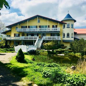
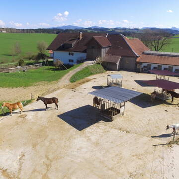
Pferdehof Moosbach
@Pferdehof_Moosbach
Freizeitstall
Pferdeausbildung
Vermieten
Führanlage
Hunde willkommen
Allergikerstall
bedampftes/gewaschenes Heu
18 weitere...
P
Deprecated: Creation of dynamic property Zend_View_Helper_Ads::$adLink is deprecated in /var/www/stall-frei/htdocs/staging.stall-frei.de/library/Psf/View/Helper/Ads.php on line 108

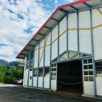
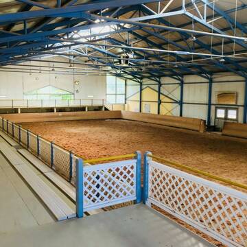
Neuer HIT Aktivstall - Gut Moosrain
Murnau am Staffelsee
Markus-Simson
@Markus-Simson
Wir bieten Ihnen das HIT Aktivstall Konzept auf dem neuesten Stand in einzigartiger Lage und in einer geschlossenen Anlage:
- Fut
brandneu
R
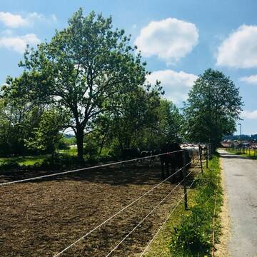

Reitanlage Pferdeturm
Wertach
Simone-Lux
@Simone-Lux
FN-Mitglied
Freizeitstall
Vermieten
Führanlage
Hunde willkommen
Hengsthaltung möglich
16 weitere...
P+
schöne Paddockboxen Außenboxen frei Reitpl 20x60
Durach
markus-pferdeglueck-durach
@Markus-pferdeglueck-durach
Freizeitstall
Geländestrecke
Vermieten
Verpachten
Hunde willkommen
Paddock
Hufrehe geeignet
18 weitere...
P
Leider kein Vorschaubild
Leider kein Vorschaubild
Pferdehof Sulzberg Hasenried
Sulzberg
angi-g
@angi-g
Freizeitstall
Pferdeausbildung
Vermieten
Führanlage
Hunde willkommen
Allergikerstall
bedampftes/gewaschenes Heu
31 weitere...
B


Offenstall/Paddocktrail
Aitrang
Pferdeparadies
@HofBayrhof
Vermieten
Longierzirkel/Roundpen
Reitplatz (z.B. Dressur, Springen, Reining)
Hufrehe geeignet
Notfallboxen
Offenstall
Paddock Trail
9 weitere...
S

Pferdepension Haneberg Kempten
Kempten
Pferdepension Haneberg
@Pferdepension-Haneberg
Freizeitstall
Vermieten
Paddock
Parkplatz für Pferdeanhänger
Gnadenbrothof
11 weitere...
P
Leider kein Vorschaubild
Leider kein Vorschaubild
Box, Offenstall, Sandauslauf, Reitplatz, 280.-€
KEMPTEN
C. August
@Claudia-August
Freizeitstall
Vermieten
Hunde willkommen
Paddock
Innenbox
Laufbox
12 weitere...
B

Aktivstall Blaslhof , der Weg lohnt sich!!
Uffing am Staffelsee
Blaslhof Aktivstall
@Blaslhof
Unser HIT Aktivstall ist 2008 mit 5 Stallsternen, der höchstmöglichen Auszeichnung für Artgerechte Pferdehaltung belohnt worde
Leider kein Vorschaubild
Leider kein Vorschaubild
Offenstallplatz für Pferd Ü20 frei 225€ monatlic...
Betzigau
Stall
@SAST
Krankenbox
Paddock
Bewegungsstall
Offenstall
Biofutter
Selbstversorgung
6 weitere...
B
Leider kein Vorschaubild
Leider kein Vorschaubild
reitanlage-dassler
Buchenberg
Gut-Buchenhof1
@Gut-Buchenhof1
Pferdeausbildung
Vermieten
Führanlage
Paddock
Hengsthaltung möglich
Pferdezucht
21 weitere...
B
Leider kein Vorschaubild
Leider kein Vorschaubild
Kleinpferde Pony Einstelllplatz
Immenstadt
Alexandra-Jaksch
@Alexandra-Jaksch
Freizeitstall
Pferdeausbildung
Verpachten
Longierzirkel/Roundpen
Paddock
Außenbox mit Paddock
Außenboxen
10 weitere...
B
Deprecated: Creation of dynamic property Zend_View::$pageCount is deprecated in /var/www/stall-frei/htdocs/staging.stall-frei.de/library/vendor/shardj/zf1-future/library/Zend/View/Abstract.php on line 308
Deprecated: Creation of dynamic property Zend_View::$itemCountPerPage is deprecated in /var/www/stall-frei/htdocs/staging.stall-frei.de/library/vendor/shardj/zf1-future/library/Zend/View/Abstract.php on line 308
Deprecated: Creation of dynamic property Zend_View::$first is deprecated in /var/www/stall-frei/htdocs/staging.stall-frei.de/library/vendor/shardj/zf1-future/library/Zend/View/Abstract.php on line 308
Deprecated: Creation of dynamic property Zend_View::$current is deprecated in /var/www/stall-frei/htdocs/staging.stall-frei.de/library/vendor/shardj/zf1-future/library/Zend/View/Abstract.php on line 308
Deprecated: Creation of dynamic property Zend_View::$last is deprecated in /var/www/stall-frei/htdocs/staging.stall-frei.de/library/vendor/shardj/zf1-future/library/Zend/View/Abstract.php on line 308
Deprecated: Creation of dynamic property Zend_View::$next is deprecated in /var/www/stall-frei/htdocs/staging.stall-frei.de/library/vendor/shardj/zf1-future/library/Zend/View/Abstract.php on line 308
Deprecated: Creation of dynamic property Zend_View::$pagesInRange is deprecated in /var/www/stall-frei/htdocs/staging.stall-frei.de/library/vendor/shardj/zf1-future/library/Zend/View/Abstract.php on line 308
Deprecated: Creation of dynamic property Zend_View::$firstPageInRange is deprecated in /var/www/stall-frei/htdocs/staging.stall-frei.de/library/vendor/shardj/zf1-future/library/Zend/View/Abstract.php on line 308
Deprecated: Creation of dynamic property Zend_View::$lastPageInRange is deprecated in /var/www/stall-frei/htdocs/staging.stall-frei.de/library/vendor/shardj/zf1-future/library/Zend/View/Abstract.php on line 308
Deprecated: Creation of dynamic property Zend_View::$currentItemCount is deprecated in /var/www/stall-frei/htdocs/staging.stall-frei.de/library/vendor/shardj/zf1-future/library/Zend/View/Abstract.php on line 308
Deprecated: Creation of dynamic property Zend_View::$totalItemCount is deprecated in /var/www/stall-frei/htdocs/staging.stall-frei.de/library/vendor/shardj/zf1-future/library/Zend/View/Abstract.php on line 308
Deprecated: Creation of dynamic property Zend_View::$firstItemNumber is deprecated in /var/www/stall-frei/htdocs/staging.stall-frei.de/library/vendor/shardj/zf1-future/library/Zend/View/Abstract.php on line 308
Deprecated: Creation of dynamic property Zend_View::$lastItemNumber is deprecated in /var/www/stall-frei/htdocs/staging.stall-frei.de/library/vendor/shardj/zf1-future/library/Zend/View/Abstract.php on line 308
Deprecated: Creation of dynamic property Zend_View::$router is deprecated in /var/www/stall-frei/htdocs/staging.stall-frei.de/library/vendor/shardj/zf1-future/library/Zend/View/Abstract.php on line 308
Deprecated: Creation of dynamic property Zend_View::$urlParams is deprecated in /var/www/stall-frei/htdocs/staging.stall-frei.de/library/vendor/shardj/zf1-future/library/Zend/View/Abstract.php on line 308
Deprecated: Creation of dynamic property Zend_View::$showAds is deprecated in /var/www/stall-frei/htdocs/staging.stall-frei.de/library/vendor/shardj/zf1-future/library/Zend/View/Abstract.php on line 308
Deprecated: Creation of dynamic property Zend_View::$objectIds is deprecated in /var/www/stall-frei/htdocs/staging.stall-frei.de/library/vendor/shardj/zf1-future/library/Zend/View/Abstract.php on line 308
Deprecated: Creation of dynamic property Zend_View::$showNavbar is deprecated in /var/www/stall-frei/htdocs/staging.stall-frei.de/library/vendor/shardj/zf1-future/library/Zend/View/Abstract.php on line 308
Deprecated: Creation of dynamic property Zend_View::$showBreadcrumb is deprecated in /var/www/stall-frei/htdocs/staging.stall-frei.de/library/vendor/shardj/zf1-future/library/Zend/View/Abstract.php on line 308
Deprecated: Creation of dynamic property Zend_View::$showFooter is deprecated in /var/www/stall-frei/htdocs/staging.stall-frei.de/library/vendor/shardj/zf1-future/library/Zend/View/Abstract.php on line 308
Deprecated: Creation of dynamic property Zend_View::$showInternalAds is deprecated in /var/www/stall-frei/htdocs/staging.stall-frei.de/library/vendor/shardj/zf1-future/library/Zend/View/Abstract.php on line 308
Deprecated: Creation of dynamic property Zend_View::$blNoContent is deprecated in /var/www/stall-frei/htdocs/staging.stall-frei.de/library/vendor/shardj/zf1-future/library/Zend/View/Abstract.php on line 308
Deprecated: Creation of dynamic property Zend_View::$sMetaDesc is deprecated in /var/www/stall-frei/htdocs/staging.stall-frei.de/library/vendor/shardj/zf1-future/library/Zend/View/Abstract.php on line 308
Deprecated: Creation of dynamic property Zend_View::$useGmaps is deprecated in /var/www/stall-frei/htdocs/staging.stall-frei.de/library/vendor/shardj/zf1-future/library/Zend/View/Abstract.php on line 308
Deprecated: Creation of dynamic property Zend_View::$touches is deprecated in /var/www/stall-frei/htdocs/staging.stall-frei.de/library/vendor/shardj/zf1-future/library/Zend/View/Abstract.php on line 308
Deprecated: Creation of dynamic property Zend_View::$oProject is deprecated in /var/www/stall-frei/htdocs/staging.stall-frei.de/library/vendor/shardj/zf1-future/library/Zend/View/Abstract.php on line 308
Deprecated: Creation of dynamic property Zend_View::$pageHeadline is deprecated in /var/www/stall-frei/htdocs/staging.stall-frei.de/library/vendor/shardj/zf1-future/library/Zend/View/Abstract.php on line 308
Deprecated: Creation of dynamic property Zend_View::$disableLocationField is deprecated in /var/www/stall-frei/htdocs/staging.stall-frei.de/library/vendor/shardj/zf1-future/library/Zend/View/Abstract.php on line 308
Deprecated: Creation of dynamic property Zend_View::$isSearch is deprecated in /var/www/stall-frei/htdocs/staging.stall-frei.de/library/vendor/shardj/zf1-future/library/Zend/View/Abstract.php on line 308
Deprecated: Creation of dynamic property Zend_View::$pageTitle is deprecated in /var/www/stall-frei/htdocs/staging.stall-frei.de/library/vendor/shardj/zf1-future/library/Zend/View/Abstract.php on line 308
Deprecated: Creation of dynamic property Psf_Form_Element_Text::$class is deprecated in /var/www/stall-frei/htdocs/staging.stall-frei.de/library/vendor/shardj/zf1-future/library/Zend/Form/Element.php on line 874
Deprecated: Creation of dynamic property Psf_Form_Element_Text::$size is deprecated in /var/www/stall-frei/htdocs/staging.stall-frei.de/library/vendor/shardj/zf1-future/library/Zend/Form/Element.php on line 874
Deprecated: Creation of dynamic property Psf_Form_Element_Text::$placeholder is deprecated in /var/www/stall-frei/htdocs/staging.stall-frei.de/library/vendor/shardj/zf1-future/library/Zend/Form/Element.php on line 874
Deprecated: Creation of dynamic property Psf_Form_Element_Hidden::$class is deprecated in /var/www/stall-frei/htdocs/staging.stall-frei.de/library/vendor/shardj/zf1-future/library/Zend/Form/Element.php on line 874
Deprecated: Creation of dynamic property Psf_Form_Element_Hidden::$class is deprecated in /var/www/stall-frei/htdocs/staging.stall-frei.de/library/vendor/shardj/zf1-future/library/Zend/Form/Element.php on line 874
Deprecated: Creation of dynamic property Psf_Form_Element_Hidden::$class is deprecated in /var/www/stall-frei/htdocs/staging.stall-frei.de/library/vendor/shardj/zf1-future/library/Zend/Form/Element.php on line 874
Deprecated: Creation of dynamic property Psf_Form_Element_Hidden::$class is deprecated in /var/www/stall-frei/htdocs/staging.stall-frei.de/library/vendor/shardj/zf1-future/library/Zend/Form/Element.php on line 874
Deprecated: Creation of dynamic property Psf_Form_Element_Select::$class is deprecated in /var/www/stall-frei/htdocs/staging.stall-frei.de/library/vendor/shardj/zf1-future/library/Zend/Form/Element.php on line 874
Deprecated: Creation of dynamic property Psf_Form_Element_Select::$class is deprecated in /var/www/stall-frei/htdocs/staging.stall-frei.de/library/vendor/shardj/zf1-future/library/Zend/Form/Element.php on line 874
Deprecated: Creation of dynamic property Psf_Form_Element_Select::$class is deprecated in /var/www/stall-frei/htdocs/staging.stall-frei.de/library/vendor/shardj/zf1-future/library/Zend/Form/Element.php on line 874
Deprecated: Creation of dynamic property Psf_Form_Element_Select::$class is deprecated in /var/www/stall-frei/htdocs/staging.stall-frei.de/library/vendor/shardj/zf1-future/library/Zend/Form/Element.php on line 874
Deprecated: Creation of dynamic property Psf_Form_Element_Text::$class is deprecated in /var/www/stall-frei/htdocs/staging.stall-frei.de/library/vendor/shardj/zf1-future/library/Zend/Form/Element.php on line 874
Deprecated: Creation of dynamic property Psf_Form_Element_Checkbox::$label is deprecated in /var/www/stall-frei/htdocs/staging.stall-frei.de/library/vendor/shardj/zf1-future/library/Zend/Form/Element.php on line 874
Deprecated: Creation of dynamic property Zend_View::$sort is deprecated in /var/www/stall-frei/htdocs/staging.stall-frei.de/library/vendor/shardj/zf1-future/library/Zend/View/Abstract.php on line 308
Deprecated: Creation of dynamic property Zend_View::$searchLocation is deprecated in /var/www/stall-frei/htdocs/staging.stall-frei.de/library/vendor/shardj/zf1-future/library/Zend/View/Abstract.php on line 308
Deprecated: Creation of dynamic property Zend_View::$locationHint is deprecated in /var/www/stall-frei/htdocs/staging.stall-frei.de/library/vendor/shardj/zf1-future/library/Zend/View/Abstract.php on line 308
Psf_GeoCoder_Abstract::getLocation: Sulzberg Get Location CachedOrLive
Psf_GeoCoder_Abstract::getCachedOrLive: Sulzberg
Psf_GeoCoder_OpenCageData::makeApiRequest: response:
Array
(
[documentation] => https://opencagedata.com/api
[licenses] => Array
(
[0] => Array
(
[name] => see attribution guide
[url] => https://opencagedata.com/credits
)
)
[results] => Array
(
[0] => Array
(
[bounds] => Array
(
[northeast] => Array
(
[lat] => 47.6922971
[lng] => 10.425295
)
[southwest] => Array
(
[lat] => 47.6163825
[lng] => 10.3041598
)
)
[components] => Array
(
[ISO_3166-1_alpha-2] => DE
[ISO_3166-1_alpha-3] => DEU
[ISO_3166-2] => Array
(
[0] => DE-BY
)
[_category] => place
[_normalized_city] => Sulzberg
[_type] => village
[continent] => Europe
[country] => Deutschland
[country_code] => de
[county] => Landkreis Oberallgäu
[political_union] => European Union
[postcode] => 87477
[state] => Bayern
[state_code] => BY
[village] => Sulzberg
)
[confidence] => 7
[formatted] => 87477 Sulzberg, Deutschland
[geometry] => Array
(
[lat] => 47.6605842
[lng] => 10.349414
)
)
[1] => Array
(
[bounds] => Array
(
[northeast] => Array
(
[lat] => 47.5749044
[lng] => 9.9558449
)
[southwest] => Array
(
[lat] => 47.5536061
[lng] => 9.9455023
)
)
[components] => Array
(
[ISO_3166-1_alpha-2] => DE
[ISO_3166-1_alpha-3] => DEU
[ISO_3166-2] => Array
(
[0] => DE-BY
)
[_category] => natural/water
[_normalized_city] => Oberreute
[_type] => ridge
[city] => Oberreute
[continent] => Europe
[country] => Deutschland
[country_code] => de
[county] => Landkreis Lindau
[hamlet] => Stadels
[municipality] => Stiefenhofen (VGem)
[political_union] => European Union
[postcode] => 88179
[ridge] => Sulzbergrücken
[state] => Bayern
[state_code] => BY
)
[confidence] => 8
[formatted] => Sulzbergrücken, Stadels, 88179 Oberreute, Deutschland
[geometry] => Array
(
[lat] => 47.5649903
[lng] => 9.948776
)
)
[2] => Array
(
[bounds] => Array
(
[northeast] => Array
(
[lat] => 47.5636555
[lng] => 9.9502659
)
[southwest] => Array
(
[lat] => 47.5634455
[lng] => 9.9488926
)
)
[components] => Array
(
[ISO_3166-1_alpha-2] => DE
[ISO_3166-1_alpha-3] => DEU
[ISO_3166-2] => Array
(
[0] => DE-BY
)
[_category] => natural/water
[_normalized_city] => Oberreute
[_type] => ridge
[city] => Oberreute
[continent] => Europe
[country] => Deutschland
[country_code] => de
[county] => Landkreis Lindau
[hamlet] => Beule
[municipality] => Stiefenhofen (VGem)
[political_union] => European Union
[postcode] => 88179
[ridge] => Sulzbergrücken
[state] => Bayern
[state_code] => BY
)
[confidence] => 9
[formatted] => Sulzbergrücken, Beule, 88179 Oberreute, Deutschland
[geometry] => Array
(
[lat] => 47.5635505
[lng] => 9.9495793
)
)
[3] => Array
(
[bounds] => Array
(
[northeast] => Array
(
[lat] => 47.7446677
[lng] => 12.0627194
)
[southwest] => Array
(
[lat] => 47.7445677
[lng] => 12.0626194
)
)
[components] => Array
(
[ISO_3166-1_alpha-2] => DE
[ISO_3166-1_alpha-3] => DEU
[ISO_3166-2] => Array
(
[0] => DE-BY
)
[_category] => natural/water
[_normalized_city] => Raubling
[_type] => peak
[continent] => Europe
[country] => Deutschland
[country_code] => de
[county] => Landkreis Rosenheim
[peak] => Sulzberg
[political_union] => European Union
[postcode] => 83098
[state] => Bayern
[state_code] => BY
[town] => Raubling
)
[confidence] => 9
[formatted] => Sulzberg, 83098 Raubling, Deutschland
[geometry] => Array
(
[lat] => 47.7446177
[lng] => 12.0626694
)
)
[4] => Array
(
[bounds] => Array
(
[northeast] => Array
(
[lat] => 51.3220802
[lng] => 9.8623179
)
[southwest] => Array
(
[lat] => 51.3219802
[lng] => 9.8622179
)
)
[components] => Array
(
[ISO_3166-1_alpha-2] => DE
[ISO_3166-1_alpha-3] => DEU
[ISO_3166-2] => Array
(
[0] => DE-HE
)
[_category] => natural/water
[_normalized_city] => Witzenhausen
[_type] => peak
[continent] => Europe
[country] => Deutschland
[country_code] => de
[county] => Werra-Meißner-Kreis
[municipality] => Witzenhausen
[peak] => Sulzberg
[political_union] => European Union
[postcode] => 37215
[state] => Hessen
[state_code] => HE
[town] => Witzenhausen
)
[confidence] => 9
[formatted] => Sulzberg, 37215 Witzenhausen, Deutschland
[geometry] => Array
(
[lat] => 51.3220302
[lng] => 9.8622679
)
)
[5] => Array
(
[bounds] => Array
(
[northeast] => Array
(
[lat] => 48.885836
[lng] => 8.377549
)
[southwest] => Array
(
[lat] => 48.885736
[lng] => 8.377449
)
)
[components] => Array
(
[ISO_3166-1_alpha-2] => DE
[ISO_3166-1_alpha-3] => DEU
[ISO_3166-2] => Array
(
[0] => DE-BW
)
[_category] => natural/water
[_normalized_city] => Malsch
[_type] => peak
[continent] => Europe
[country] => Deutschland
[country_code] => de
[county] => Landkreis Karlsruhe
[peak] => Sulzberg
[political_union] => European Union
[postcode] => 76316
[state] => Baden-Württemberg
[state_code] => BW
[town] => Malsch
)
[confidence] => 9
[formatted] => Sulzberg, 76316 Malsch, Deutschland
[geometry] => Array
(
[lat] => 48.885786
[lng] => 8.377499
)
)
[6] => Array
(
[bounds] => Array
(
[northeast] => Array
(
[lat] => 49.4742587
[lng] => 7.8073484
)
[southwest] => Array
(
[lat] => 49.4741587
[lng] => 7.8072484
)
)
[components] => Array
(
[ISO_3166-1_alpha-2] => DE
[ISO_3166-1_alpha-3] => DEU
[ISO_3166-2] => Array
(
[0] => DE-RP
)
[_category] => natural/water
[_normalized_city] => Mehlingen
[_type] => peak
[continent] => Europe
[country] => Deutschland
[country_code] => de
[county] => Landkreis Kaiserslautern
[municipality] => Enkenbach-Alsenborn
[peak] => Sulzberg
[political_union] => European Union
[postcode] => 67657
[state] => Rheinland-Pfalz
[state_code] => RP
[village] => Mehlingen
)
[confidence] => 9
[formatted] => Sulzberg, 67657 Mehlingen, Deutschland
[geometry] => Array
(
[lat] => 49.4742087
[lng] => 7.8072984
)
)
[7] => Array
(
[bounds] => Array
(
[northeast] => Array
(
[lat] => 48.8291122
[lng] => 13.6618048
)
[southwest] => Array
(
[lat] => 48.8290122
[lng] => 13.6617048
)
)
[components] => Array
(
[ISO_3166-1_alpha-2] => DE
[ISO_3166-1_alpha-3] => DEU
[ISO_3166-2] => Array
(
[0] => DE-BY
)
[_category] => natural/water
[_normalized_city] => Schlichtenberger Wald
[_type] => peak
[city] => Schlichtenberger Wald
[continent] => Europe
[country] => Deutschland
[country_code] => de
[county] => Landkreis Freyung-Grafenau
[peak] => Sulzberg
[political_union] => European Union
[postcode] => 94143
[state] => Bayern
[state_code] => BY
)
[confidence] => 9
[formatted] => Sulzberg, 94143 Schlichtenberger Wald, Deutschland
[geometry] => Array
(
[lat] => 48.8290622
[lng] => 13.6617548
)
)
[8] => Array
(
[bounds] => Array
(
[northeast] => Array
(
[lat] => 49.5772185
[lng] => 7.4709151
)
[southwest] => Array
(
[lat] => 49.5771185
[lng] => 7.4708151
)
)
[components] => Array
(
[ISO_3166-1_alpha-2] => DE
[ISO_3166-1_alpha-3] => DEU
[ISO_3166-2] => Array
(
[0] => DE-RP
)
[_category] => natural/water
[_normalized_city] => Ulmet
[_type] => peak
[continent] => Europe
[country] => Deutschland
[country_code] => de
[county] => Landkreis Kusel
[municipality] => Kusel-Altenglan
[peak] => Sulzberg
[political_union] => European Union
[postcode] => 66887
[state] => Rheinland-Pfalz
[state_code] => RP
[village] => Ulmet
)
[confidence] => 9
[formatted] => Sulzberg, 66887 Ulmet, Deutschland
[geometry] => Array
(
[lat] => 49.5771685
[lng] => 7.4708651
)
)
[9] => Array
(
[bounds] => Array
(
[northeast] => Array
(
[lat] => 49.9190857
[lng] => 9.1795209
)
[southwest] => Array
(
[lat] => 49.9189857
[lng] => 9.1794209
)
)
[components] => Array
(
[ISO_3166-1_alpha-2] => DE
[ISO_3166-1_alpha-3] => DEU
[ISO_3166-2] => Array
(
[0] => DE-BY
)
[_category] => natural/water
[_normalized_city] => Sulzbach am Main
[_type] => peak
[continent] => Europe
[country] => Deutschland
[country_code] => de
[county] => Landkreis Miltenberg
[peak] => Sulzberg
[political_union] => European Union
[postcode] => 63834
[state] => Bayern
[state_code] => BY
[village] => Sulzbach am Main
)
[confidence] => 9
[formatted] => Sulzberg, 63834 Sulzbach am Main, Deutschland
[geometry] => Array
(
[lat] => 49.9190357
[lng] => 9.1794709
)
)
)
[status] => Array
(
[code] => 200
[message] => OK
)
[stay_informed] => Array
(
[blog] => https://blog.opencagedata.com
[mastodon] => https://en.osm.town/@opencage
)
[thanks] => For using an OpenCage API
[timestamp] => Array
(
[created_http] => Sat, 07 Feb 2026 15:48:13 GMT
[created_unix] => 1770479293
)
[total_results] => 10
)
Psf_GeoCoder_Abstract::convertLocationResult
{"documentation":"https:\/\/opencagedata.com\/api","licenses":[{"name":"see attribution guide","url":"https:\/\/opencagedata.com\/credits"}],"results":[{"bounds":{"northeast":{"lat":47.6922971,"lng":10.425295},"southwest":{"lat":47.6163825,"lng":10.3041598}},"components":{"ISO_3166-1_alpha-2":"DE","ISO_3166-1_alpha-3":"DEU","ISO_3166-2":["DE-BY"],"_category":"place","_normalized_city":"Sulzberg","_type":"village","continent":"Europe","country":"Deutschland","country_code":"de","county":"Landkreis Oberallg\u00e4u","political_union":"European Union","postcode":"87477","state":"Bayern","state_code":"BY","village":"Sulzberg"},"confidence":7,"formatted":"87477 Sulzberg, Deutschland","geometry":{"lat":47.6605842,"lng":10.349414}},{"bounds":{"northeast":{"lat":47.5749044,"lng":9.9558449},"southwest":{"lat":47.5536061,"lng":9.9455023}},"components":{"ISO_3166-1_alpha-2":"DE","ISO_3166-1_alpha-3":"DEU","ISO_3166-2":["DE-BY"],"_category":"natural\/water","_normalized_city":"Oberreute","_type":"ridge","city":"Oberreute","continent":"Europe","country":"Deutschland","country_code":"de","county":"Landkreis Lindau","hamlet":"Stadels","municipality":"Stiefenhofen (VGem)","political_union":"European Union","postcode":"88179","ridge":"Sulzbergr\u00fccken","state":"Bayern","state_code":"BY"},"confidence":8,"formatted":"Sulzbergr\u00fccken, Stadels, 88179 Oberreute, Deutschland","geometry":{"lat":47.5649903,"lng":9.948776}},{"bounds":{"northeast":{"lat":47.5636555,"lng":9.9502659},"southwest":{"lat":47.5634455,"lng":9.9488926}},"components":{"ISO_3166-1_alpha-2":"DE","ISO_3166-1_alpha-3":"DEU","ISO_3166-2":["DE-BY"],"_category":"natural\/water","_normalized_city":"Oberreute","_type":"ridge","city":"Oberreute","continent":"Europe","country":"Deutschland","country_code":"de","county":"Landkreis Lindau","hamlet":"Beule","municipality":"Stiefenhofen (VGem)","political_union":"European Union","postcode":"88179","ridge":"Sulzbergr\u00fccken","state":"Bayern","state_code":"BY"},"confidence":9,"formatted":"Sulzbergr\u00fccken, Beule, 88179 Oberreute, Deutschland","geometry":{"lat":47.5635505,"lng":9.9495793}},{"bounds":{"northeast":{"lat":47.7446677,"lng":12.0627194},"southwest":{"lat":47.7445677,"lng":12.0626194}},"components":{"ISO_3166-1_alpha-2":"DE","ISO_3166-1_alpha-3":"DEU","ISO_3166-2":["DE-BY"],"_category":"natural\/water","_normalized_city":"Raubling","_type":"peak","continent":"Europe","country":"Deutschland","country_code":"de","county":"Landkreis Rosenheim","peak":"Sulzberg","political_union":"European Union","postcode":"83098","state":"Bayern","state_code":"BY","town":"Raubling"},"confidence":9,"formatted":"Sulzberg, 83098 Raubling, Deutschland","geometry":{"lat":47.7446177,"lng":12.0626694}},{"bounds":{"northeast":{"lat":51.3220802,"lng":9.8623179},"southwest":{"lat":51.3219802,"lng":9.8622179}},"components":{"ISO_3166-1_alpha-2":"DE","ISO_3166-1_alpha-3":"DEU","ISO_3166-2":["DE-HE"],"_category":"natural\/water","_normalized_city":"Witzenhausen","_type":"peak","continent":"Europe","country":"Deutschland","country_code":"de","county":"Werra-Mei\u00dfner-Kreis","municipality":"Witzenhausen","peak":"Sulzberg","political_union":"European Union","postcode":"37215","state":"Hessen","state_code":"HE","town":"Witzenhausen"},"confidence":9,"formatted":"Sulzberg, 37215 Witzenhausen, Deutschland","geometry":{"lat":51.3220302,"lng":9.8622679}},{"bounds":{"northeast":{"lat":48.885836,"lng":8.377549},"southwest":{"lat":48.885736,"lng":8.377449}},"components":{"ISO_3166-1_alpha-2":"DE","ISO_3166-1_alpha-3":"DEU","ISO_3166-2":["DE-BW"],"_category":"natural\/water","_normalized_city":"Malsch","_type":"peak","continent":"Europe","country":"Deutschland","country_code":"de","county":"Landkreis Karlsruhe","peak":"Sulzberg","political_union":"European Union","postcode":"76316","state":"Baden-W\u00fcrttemberg","state_code":"BW","town":"Malsch"},"confidence":9,"formatted":"Sulzberg, 76316 Malsch, Deutschland","geometry":{"lat":48.885786,"lng":8.377499}},{"bounds":{"northeast":{"lat":49.4742587,"lng":7.8073484},"southwest":{"lat":49.4741587,"lng":7.8072484}},"components":{"ISO_3166-1_alpha-2":"DE","ISO_3166-1_alpha-3":"DEU","ISO_3166-2":["DE-RP"],"_category":"natural\/water","_normalized_city":"Mehlingen","_type":"peak","continent":"Europe","country":"Deutschland","country_code":"de","county":"Landkreis Kaiserslautern","municipality":"Enkenbach-Alsenborn","peak":"Sulzberg","political_union":"European Union","postcode":"67657","state":"Rheinland-Pfalz","state_code":"RP","village":"Mehlingen"},"confidence":9,"formatted":"Sulzberg, 67657 Mehlingen, Deutschland","geometry":{"lat":49.4742087,"lng":7.8072984}},{"bounds":{"northeast":{"lat":48.8291122,"lng":13.6618048},"southwest":{"lat":48.8290122,"lng":13.6617048}},"components":{"ISO_3166-1_alpha-2":"DE","ISO_3166-1_alpha-3":"DEU","ISO_3166-2":["DE-BY"],"_category":"natural\/water","_normalized_city":"Schlichtenberger Wald","_type":"peak","city":"Schlichtenberger Wald","continent":"Europe","country":"Deutschland","country_code":"de","county":"Landkreis Freyung-Grafenau","peak":"Sulzberg","political_union":"European Union","postcode":"94143","state":"Bayern","state_code":"BY"},"confidence":9,"formatted":"Sulzberg, 94143 Schlichtenberger Wald, Deutschland","geometry":{"lat":48.8290622,"lng":13.6617548}},{"bounds":{"northeast":{"lat":49.5772185,"lng":7.4709151},"southwest":{"lat":49.5771185,"lng":7.4708151}},"components":{"ISO_3166-1_alpha-2":"DE","ISO_3166-1_alpha-3":"DEU","ISO_3166-2":["DE-RP"],"_category":"natural\/water","_normalized_city":"Ulmet","_type":"peak","continent":"Europe","country":"Deutschland","country_code":"de","county":"Landkreis Kusel","municipality":"Kusel-Altenglan","peak":"Sulzberg","political_union":"European Union","postcode":"66887","state":"Rheinland-Pfalz","state_code":"RP","village":"Ulmet"},"confidence":9,"formatted":"Sulzberg, 66887 Ulmet, Deutschland","geometry":{"lat":49.5771685,"lng":7.4708651}},{"bounds":{"northeast":{"lat":49.9190857,"lng":9.1795209},"southwest":{"lat":49.9189857,"lng":9.1794209}},"components":{"ISO_3166-1_alpha-2":"DE","ISO_3166-1_alpha-3":"DEU","ISO_3166-2":["DE-BY"],"_category":"natural\/water","_normalized_city":"Sulzbach am Main","_type":"peak","continent":"Europe","country":"Deutschland","country_code":"de","county":"Landkreis Miltenberg","peak":"Sulzberg","political_union":"European Union","postcode":"63834","state":"Bayern","state_code":"BY","village":"Sulzbach am Main"},"confidence":9,"formatted":"Sulzberg, 63834 Sulzbach am Main, Deutschland","geometry":{"lat":49.9190357,"lng":9.1794709}}],"status":{"code":200,"message":"OK"},"stay_informed":{"blog":"https:\/\/blog.opencagedata.com","mastodon":"https:\/\/en.osm.town\/@opencage"},"thanks":"For using an OpenCage API","timestamp":{"created_http":"Sat, 07 Feb 2026 15:48:13 GMT","created_unix":1770479293},"total_results":10}Array
(
[0] => stdClass Object
(
[bounds] => stdClass Object
(
[northeast] => stdClass Object
(
[lat] => 47.6922971
[lng] => 10.425295
)
[southwest] => stdClass Object
(
[lat] => 47.6163825
[lng] => 10.3041598
)
)
[components] => stdClass Object
(
[ISO_3166-1_alpha-2] => DE
[ISO_3166-1_alpha-3] => DEU
[ISO_3166-2] => Array
(
[0] => DE-BY
)
[_category] => place
[_normalized_city] => Sulzberg
[_type] => village
[continent] => Europe
[country] => Deutschland
[country_code] => de
[county] => Landkreis Oberallgäu
[political_union] => European Union
[postcode] => 87477
[state] => Bayern
[state_code] => BY
[village] => Sulzberg
)
[confidence] => 7
[formatted] => 87477 Sulzberg, Deutschland
[geometry] => stdClass Object
(
[lat] => 47.6605842
[lng] => 10.349414
)
)
[1] => stdClass Object
(
[bounds] => stdClass Object
(
[northeast] => stdClass Object
(
[lat] => 47.5749044
[lng] => 9.9558449
)
[southwest] => stdClass Object
(
[lat] => 47.5536061
[lng] => 9.9455023
)
)
[components] => stdClass Object
(
[ISO_3166-1_alpha-2] => DE
[ISO_3166-1_alpha-3] => DEU
[ISO_3166-2] => Array
(
[0] => DE-BY
)
[_category] => natural/water
[_normalized_city] => Oberreute
[_type] => ridge
[city] => Oberreute
[continent] => Europe
[country] => Deutschland
[country_code] => de
[county] => Landkreis Lindau
[hamlet] => Stadels
[municipality] => Stiefenhofen (VGem)
[political_union] => European Union
[postcode] => 88179
[ridge] => Sulzbergrücken
[state] => Bayern
[state_code] => BY
)
[confidence] => 8
[formatted] => Sulzbergrücken, Stadels, 88179 Oberreute, Deutschland
[geometry] => stdClass Object
(
[lat] => 47.5649903
[lng] => 9.948776
)
)
[2] => stdClass Object
(
[bounds] => stdClass Object
(
[northeast] => stdClass Object
(
[lat] => 47.5636555
[lng] => 9.9502659
)
[southwest] => stdClass Object
(
[lat] => 47.5634455
[lng] => 9.9488926
)
)
[components] => stdClass Object
(
[ISO_3166-1_alpha-2] => DE
[ISO_3166-1_alpha-3] => DEU
[ISO_3166-2] => Array
(
[0] => DE-BY
)
[_category] => natural/water
[_normalized_city] => Oberreute
[_type] => ridge
[city] => Oberreute
[continent] => Europe
[country] => Deutschland
[country_code] => de
[county] => Landkreis Lindau
[hamlet] => Beule
[municipality] => Stiefenhofen (VGem)
[political_union] => European Union
[postcode] => 88179
[ridge] => Sulzbergrücken
[state] => Bayern
[state_code] => BY
)
[confidence] => 9
[formatted] => Sulzbergrücken, Beule, 88179 Oberreute, Deutschland
[geometry] => stdClass Object
(
[lat] => 47.5635505
[lng] => 9.9495793
)
)
[3] => stdClass Object
(
[bounds] => stdClass Object
(
[northeast] => stdClass Object
(
[lat] => 47.7446677
[lng] => 12.0627194
)
[southwest] => stdClass Object
(
[lat] => 47.7445677
[lng] => 12.0626194
)
)
[components] => stdClass Object
(
[ISO_3166-1_alpha-2] => DE
[ISO_3166-1_alpha-3] => DEU
[ISO_3166-2] => Array
(
[0] => DE-BY
)
[_category] => natural/water
[_normalized_city] => Raubling
[_type] => peak
[continent] => Europe
[country] => Deutschland
[country_code] => de
[county] => Landkreis Rosenheim
[peak] => Sulzberg
[political_union] => European Union
[postcode] => 83098
[state] => Bayern
[state_code] => BY
[town] => Raubling
)
[confidence] => 9
[formatted] => Sulzberg, 83098 Raubling, Deutschland
[geometry] => stdClass Object
(
[lat] => 47.7446177
[lng] => 12.0626694
)
)
[4] => stdClass Object
(
[bounds] => stdClass Object
(
[northeast] => stdClass Object
(
[lat] => 51.3220802
[lng] => 9.8623179
)
[southwest] => stdClass Object
(
[lat] => 51.3219802
[lng] => 9.8622179
)
)
[components] => stdClass Object
(
[ISO_3166-1_alpha-2] => DE
[ISO_3166-1_alpha-3] => DEU
[ISO_3166-2] => Array
(
[0] => DE-HE
)
[_category] => natural/water
[_normalized_city] => Witzenhausen
[_type] => peak
[continent] => Europe
[country] => Deutschland
[country_code] => de
[county] => Werra-Meißner-Kreis
[municipality] => Witzenhausen
[peak] => Sulzberg
[political_union] => European Union
[postcode] => 37215
[state] => Hessen
[state_code] => HE
[town] => Witzenhausen
)
[confidence] => 9
[formatted] => Sulzberg, 37215 Witzenhausen, Deutschland
[geometry] => stdClass Object
(
[lat] => 51.3220302
[lng] => 9.8622679
)
)
[5] => stdClass Object
(
[bounds] => stdClass Object
(
[northeast] => stdClass Object
(
[lat] => 48.885836
[lng] => 8.377549
)
[southwest] => stdClass Object
(
[lat] => 48.885736
[lng] => 8.377449
)
)
[components] => stdClass Object
(
[ISO_3166-1_alpha-2] => DE
[ISO_3166-1_alpha-3] => DEU
[ISO_3166-2] => Array
(
[0] => DE-BW
)
[_category] => natural/water
[_normalized_city] => Malsch
[_type] => peak
[continent] => Europe
[country] => Deutschland
[country_code] => de
[county] => Landkreis Karlsruhe
[peak] => Sulzberg
[political_union] => European Union
[postcode] => 76316
[state] => Baden-Württemberg
[state_code] => BW
[town] => Malsch
)
[confidence] => 9
[formatted] => Sulzberg, 76316 Malsch, Deutschland
[geometry] => stdClass Object
(
[lat] => 48.885786
[lng] => 8.377499
)
)
[6] => stdClass Object
(
[bounds] => stdClass Object
(
[northeast] => stdClass Object
(
[lat] => 49.4742587
[lng] => 7.8073484
)
[southwest] => stdClass Object
(
[lat] => 49.4741587
[lng] => 7.8072484
)
)
[components] => stdClass Object
(
[ISO_3166-1_alpha-2] => DE
[ISO_3166-1_alpha-3] => DEU
[ISO_3166-2] => Array
(
[0] => DE-RP
)
[_category] => natural/water
[_normalized_city] => Mehlingen
[_type] => peak
[continent] => Europe
[country] => Deutschland
[country_code] => de
[county] => Landkreis Kaiserslautern
[municipality] => Enkenbach-Alsenborn
[peak] => Sulzberg
[political_union] => European Union
[postcode] => 67657
[state] => Rheinland-Pfalz
[state_code] => RP
[village] => Mehlingen
)
[confidence] => 9
[formatted] => Sulzberg, 67657 Mehlingen, Deutschland
[geometry] => stdClass Object
(
[lat] => 49.4742087
[lng] => 7.8072984
)
)
[7] => stdClass Object
(
[bounds] => stdClass Object
(
[northeast] => stdClass Object
(
[lat] => 48.8291122
[lng] => 13.6618048
)
[southwest] => stdClass Object
(
[lat] => 48.8290122
[lng] => 13.6617048
)
)
[components] => stdClass Object
(
[ISO_3166-1_alpha-2] => DE
[ISO_3166-1_alpha-3] => DEU
[ISO_3166-2] => Array
(
[0] => DE-BY
)
[_category] => natural/water
[_normalized_city] => Schlichtenberger Wald
[_type] => peak
[city] => Schlichtenberger Wald
[continent] => Europe
[country] => Deutschland
[country_code] => de
[county] => Landkreis Freyung-Grafenau
[peak] => Sulzberg
[political_union] => European Union
[postcode] => 94143
[state] => Bayern
[state_code] => BY
)
[confidence] => 9
[formatted] => Sulzberg, 94143 Schlichtenberger Wald, Deutschland
[geometry] => stdClass Object
(
[lat] => 48.8290622
[lng] => 13.6617548
)
)
[8] => stdClass Object
(
[bounds] => stdClass Object
(
[northeast] => stdClass Object
(
[lat] => 49.5772185
[lng] => 7.4709151
)
[southwest] => stdClass Object
(
[lat] => 49.5771185
[lng] => 7.4708151
)
)
[components] => stdClass Object
(
[ISO_3166-1_alpha-2] => DE
[ISO_3166-1_alpha-3] => DEU
[ISO_3166-2] => Array
(
[0] => DE-RP
)
[_category] => natural/water
[_normalized_city] => Ulmet
[_type] => peak
[continent] => Europe
[country] => Deutschland
[country_code] => de
[county] => Landkreis Kusel
[municipality] => Kusel-Altenglan
[peak] => Sulzberg
[political_union] => European Union
[postcode] => 66887
[state] => Rheinland-Pfalz
[state_code] => RP
[village] => Ulmet
)
[confidence] => 9
[formatted] => Sulzberg, 66887 Ulmet, Deutschland
[geometry] => stdClass Object
(
[lat] => 49.5771685
[lng] => 7.4708651
)
)
[9] => stdClass Object
(
[bounds] => stdClass Object
(
[northeast] => stdClass Object
(
[lat] => 49.9190857
[lng] => 9.1795209
)
[southwest] => stdClass Object
(
[lat] => 49.9189857
[lng] => 9.1794209
)
)
[components] => stdClass Object
(
[ISO_3166-1_alpha-2] => DE
[ISO_3166-1_alpha-3] => DEU
[ISO_3166-2] => Array
(
[0] => DE-BY
)
[_category] => natural/water
[_normalized_city] => Sulzbach am Main
[_type] => peak
[continent] => Europe
[country] => Deutschland
[country_code] => de
[county] => Landkreis Miltenberg
[peak] => Sulzberg
[political_union] => European Union
[postcode] => 63834
[state] => Bayern
[state_code] => BY
[village] => Sulzbach am Main
)
[confidence] => 9
[formatted] => Sulzberg, 63834 Sulzbach am Main, Deutschland
[geometry] => stdClass Object
(
[lat] => 49.9190357
[lng] => 9.1794709
)
)
)
Psf_GeoCoder_OpenCageData::getKeyMap: 0
stdClass Object
(
    [bounds] => stdClass Object
        (
            [northeast] => stdClass Object
                (
                    [lat] => 47.6922971
                    [lng] => 10.425295
                )

            [southwest] => stdClass Object
                (
                    [lat] => 47.6163825
                    [lng] => 10.3041598
                )

        )

    [components] => stdClass Object
        (
            [ISO_3166-1_alpha-2] => DE
            [ISO_3166-1_alpha-3] => DEU
            [ISO_3166-2] => Array
                (
                    [0] => DE-BY
                )

            [_category] => place
            [_normalized_city] => Sulzberg
            [_type] => village
            [continent] => Europe
            [country] => Deutschland
            [country_code] => de
            [county] => Landkreis Oberallgäu
            [political_union] => European Union
            [postcode] => 87477
            [state] => Bayern
            [state_code] => BY
            [village] => Sulzberg
        )

    [confidence] => 7
    [formatted] => 87477 Sulzberg, Deutschland
    [geometry] => stdClass Object
        (
            [lat] => 47.6605842
            [lng] => 10.349414
        )

)
Psf_GeoCoder_OpenCageData::getCounty: Oberallgäu
Psf_GeoCoder_OpenCageData::addMissingData REFETCH!
Array
(
    [address] => 87477 Sulzberg, Deutschland
    [type] => village
    [street] =>
    [city] => Sulzberg
    [county] => Oberallgäu
    [state] => Bayern
    [zip] => 87477
    [country] => Deutschland
    [suburb] =>
    [countrycode] => de
    [latitude] => 47.6605842
    [longitude] => 10.349414
    [accuracy] => 1
    [confidence] => 7
    [bounds] => stdClass Object
        (
            [northeast] => stdClass Object
                (
                    [lat] => 47.6922971
                    [lng] => 10.425295
                )

            [southwest] => stdClass Object
                (
                    [lat] => 47.6163825
                    [lng] => 10.3041598
                )

        )

)
reformat!
Array
(
    [address] => 87477 Sulzberg, Deutschland
    [type] => village
    [street] =>
    [city] => Sulzberg
    [county] => Oberallgäu
    [state] => Bayern
    [zip] => 87477
    [country] => Deutschland
    [suburb] =>
    [countrycode] => de
    [latitude] => 47.6605842
    [longitude] => 10.349414
    [accuracy] => 1
    [confidence] => 7
    [bounds] => stdClass Object
        (
            [northeast] => stdClass Object
                (
                    [lat] => 47.6922971
                    [lng] => 10.425295
                )

            [southwest] => stdClass Object
                (
                    [lat] => 47.6163825
                    [lng] => 10.3041598
                )

        )

    [place] => 87477 Sulzberg, Bayern
    [hash] => 0ff04f7b794ac8efddc54d9a16359d14
)
Psf_GeoCoder_OpenCageData::getKeyMap: 1
stdClass Object
(
    [bounds] => stdClass Object
        (
            [northeast] => stdClass Object
                (
                    [lat] => 47.5749044
                    [lng] => 9.9558449
                )

            [southwest] => stdClass Object
                (
                    [lat] => 47.5536061
                    [lng] => 9.9455023
                )

        )

    [components] => stdClass Object
        (
            [ISO_3166-1_alpha-2] => DE
            [ISO_3166-1_alpha-3] => DEU
            [ISO_3166-2] => Array
                (
                    [0] => DE-BY
                )

            [_category] => natural/water
            [_normalized_city] => Oberreute
            [_type] => ridge
            [city] => Oberreute
            [continent] => Europe
            [country] => Deutschland
            [country_code] => de
            [county] => Landkreis Lindau
            [hamlet] => Stadels
            [municipality] => Stiefenhofen (VGem)
            [political_union] => European Union
            [postcode] => 88179
            [ridge] => Sulzbergrücken
            [state] => Bayern
            [state_code] => BY
        )

    [confidence] => 8
    [formatted] => Sulzbergrücken, Stadels, 88179 Oberreute, Deutschland
    [geometry] => stdClass Object
        (
            [lat] => 47.5649903
            [lng] => 9.948776
        )

)
Psf_GeoCoder_OpenCageData::getCounty: Lindau
Psf_GeoCoder_OpenCageData::addMissingData REFETCH!
Array
(
    [address] => Sulzbergrücken, Stadels, 88179 Oberreute, Deutschland
    [type] => ridge
    [street] => Stadels
    [city] => Oberreute
    [county] => Lindau
    [state] => Bayern
    [zip] => 88179
    [country] => Deutschland
    [suburb] =>
    [countrycode] => de
    [latitude] => 47.5649903
    [longitude] => 9.948776
    [accuracy] => 1
    [confidence] => 8
    [bounds] => stdClass Object
        (
            [northeast] => stdClass Object
                (
                    [lat] => 47.5749044
                    [lng] => 9.9558449
                )

            [southwest] => stdClass Object
                (
                    [lat] => 47.5536061
                    [lng] => 9.9455023
                )

        )

)
reformat!
Array
(
    [address] => Sulzbergrücken, Stadels, 88179 Oberreute, Deutschland
    [type] => ridge
    [street] => Stadels
    [city] => Oberreute
    [county] => Lindau
    [state] => Bayern
    [zip] => 88179
    [country] => Deutschland
    [suburb] =>
    [countrycode] => de
    [latitude] => 47.5649903
    [longitude] => 9.948776
    [accuracy] => 1
    [confidence] => 8
    [bounds] => stdClass Object
        (
            [northeast] => stdClass Object
                (
                    [lat] => 47.5749044
                    [lng] => 9.9558449
                )

            [southwest] => stdClass Object
                (
                    [lat] => 47.5536061
                    [lng] => 9.9455023
                )

        )

    [place] => Stadels, 88179 Oberreute, Bayern
    [hash] => 2ba94e58cdac903a324288d5aaf30552
)
Psf_GeoCoder_OpenCageData::getKeyMap: 2
stdClass Object
(
    [bounds] => stdClass Object
        (
            [northeast] => stdClass Object
                (
                    [lat] => 47.5636555
                    [lng] => 9.9502659
                )

            [southwest] => stdClass Object
                (
                    [lat] => 47.5634455
                    [lng] => 9.9488926
                )

        )

    [components] => stdClass Object
        (
            [ISO_3166-1_alpha-2] => DE
            [ISO_3166-1_alpha-3] => DEU
            [ISO_3166-2] => Array
                (
                    [0] => DE-BY
                )

            [_category] => natural/water
            [_normalized_city] => Oberreute
            [_type] => ridge
            [city] => Oberreute
            [continent] => Europe
            [country] => Deutschland
            [country_code] => de
            [county] => Landkreis Lindau
            [hamlet] => Beule
            [municipality] => Stiefenhofen (VGem)
            [political_union] => European Union
            [postcode] => 88179
            [ridge] => Sulzbergrücken
            [state] => Bayern
            [state_code] => BY
        )

    [confidence] => 9
    [formatted] => Sulzbergrücken, Beule, 88179 Oberreute, Deutschland
    [geometry] => stdClass Object
        (
            [lat] => 47.5635505
            [lng] => 9.9495793
        )

)
Psf_GeoCoder_OpenCageData::getCounty: Lindau
Psf_GeoCoder_OpenCageData::addMissingData REFETCH!
Array
(
    [address] => Sulzbergrücken, Beule, 88179 Oberreute, Deutschland
    [type] => ridge
    [street] => Beule
    [city] => Oberreute
    [county] => Lindau
    [state] => Bayern
    [zip] => 88179
    [country] => Deutschland
    [suburb] =>
    [countrycode] => de
    [latitude] => 47.5635505
    [longitude] => 9.9495793
    [accuracy] => 1
    [confidence] => 9
    [bounds] => stdClass Object
        (
            [northeast] => stdClass Object
                (
                    [lat] => 47.5636555
                    [lng] => 9.9502659
                )

            [southwest] => stdClass Object
                (
                    [lat] => 47.5634455
                    [lng] => 9.9488926
                )

        )

)
reformat!
Array
(
    [address] => Sulzbergrücken, Beule, 88179 Oberreute, Deutschland
    [type] => ridge
    [street] => Beule
    [city] => Oberreute
    [county] => Lindau
    [state] => Bayern
    [zip] => 88179
    [country] => Deutschland
    [suburb] =>
    [countrycode] => de
    [latitude] => 47.5635505
    [longitude] => 9.9495793
    [accuracy] => 1
    [confidence] => 9
    [bounds] => stdClass Object
        (
            [northeast] => stdClass Object
                (
                    [lat] => 47.5636555
                    [lng] => 9.9502659
                )

            [southwest] => stdClass Object
                (
                    [lat] => 47.5634455
                    [lng] => 9.9488926
                )

        )

    [place] => Beule, 88179 Oberreute, Bayern
    [hash] => f8e966b9ad0c613729e30571a47b8d0b
)
Psf_GeoCoder_OpenCageData::getKeyMap: 3
stdClass Object
(
    [bounds] => stdClass Object
        (
            [northeast] => stdClass Object
                (
                    [lat] => 47.7446677
                    [lng] => 12.0627194
                )

            [southwest] => stdClass Object
                (
                    [lat] => 47.7445677
                    [lng] => 12.0626194
                )

        )

    [components] => stdClass Object
        (
            [ISO_3166-1_alpha-2] => DE
            [ISO_3166-1_alpha-3] => DEU
            [ISO_3166-2] => Array
                (
                    [0] => DE-BY
                )

            [_category] => natural/water
            [_normalized_city] => Raubling
            [_type] => peak
            [continent] => Europe
            [country] => Deutschland
            [country_code] => de
            [county] => Landkreis Rosenheim
            [peak] => Sulzberg
            [political_union] => European Union
            [postcode] => 83098
            [state] => Bayern
            [state_code] => BY
            [town] => Raubling
        )

    [confidence] => 9
    [formatted] => Sulzberg, 83098 Raubling, Deutschland
    [geometry] => stdClass Object
        (
            [lat] => 47.7446177
            [lng] => 12.0626694
        )

)
Psf_GeoCoder_OpenCageData::getCounty: Rosenheim
Psf_GeoCoder_OpenCageData::addMissingData REFETCH!
Array
(
    [address] => Sulzberg, 83098 Raubling, Deutschland
    [type] => peak
    [street] =>
    [city] => Raubling
    [county] => Rosenheim
    [state] => Bayern
    [zip] => 83098
    [country] => Deutschland
    [suburb] =>
    [countrycode] => de
    [latitude] => 47.7446177
    [longitude] => 12.0626694
    [accuracy] => 1
    [confidence] => 9
    [bounds] => stdClass Object
        (
            [northeast] => stdClass Object
                (
                    [lat] => 47.7446677
                    [lng] => 12.0627194
                )

            [southwest] => stdClass Object
                (
                    [lat] => 47.7445677
                    [lng] => 12.0626194
                )

        )

)
reformat!
Array
(
    [address] => Sulzberg, 83098 Raubling, Deutschland
    [type] => peak
    [street] =>
    [city] => Raubling
    [county] => Rosenheim
    [state] => Bayern
    [zip] => 83098
    [country] => Deutschland
    [suburb] =>
    [countrycode] => de
    [latitude] => 47.7446177
    [longitude] => 12.0626694
    [accuracy] => 1
    [confidence] => 9
    [bounds] => stdClass Object
        (
            [northeast] => stdClass Object
                (
                    [lat] => 47.7446677
                    [lng] => 12.0627194
                )

            [southwest] => stdClass Object
                (
                    [lat] => 47.7445677
                    [lng] => 12.0626194
                )

        )

    [place] => 83098 Raubling, Bayern
    [hash] => c8e7ca17cd4d307e6f102b93c2731745
)
Psf_GeoCoder_OpenCageData::getKeyMap: 4
stdClass Object
(
    [bounds] => stdClass Object
        (
            [northeast] => stdClass Object
                (
                    [lat] => 51.3220802
                    [lng] => 9.8623179
                )

            [southwest] => stdClass Object
                (
                    [lat] => 51.3219802
                    [lng] => 9.8622179
                )

        )

    [components] => stdClass Object
        (
            [ISO_3166-1_alpha-2] => DE
            [ISO_3166-1_alpha-3] => DEU
            [ISO_3166-2] => Array
                (
                    [0] => DE-HE
                )

            [_category] => natural/water
            [_normalized_city] => Witzenhausen
            [_type] => peak
            [continent] => Europe
            [country] => Deutschland
            [country_code] => de
            [county] => Werra-Meißner-Kreis
            [municipality] => Witzenhausen
            [peak] => Sulzberg
            [political_union] => European Union
            [postcode] => 37215
            [state] => Hessen
            [state_code] => HE
            [town] => Witzenhausen
        )

    [confidence] => 9
    [formatted] => Sulzberg, 37215 Witzenhausen, Deutschland
    [geometry] => stdClass Object
        (
            [lat] => 51.3220302
            [lng] => 9.8622679
        )

)
Psf_GeoCoder_OpenCageData::getCounty: Werra-Meißner-Kreis
Psf_GeoCoder_OpenCageData::addMissingData REFETCH!
Array
(
    [address] => Sulzberg, 37215 Witzenhausen, Deutschland
    [type] => peak
    [street] =>
    [city] => Witzenhausen
    [county] => Werra-Meißner-Kreis
    [state] => Hessen
    [zip] => 37215
    [country] => Deutschland
    [suburb] =>
    [countrycode] => de
    [latitude] => 51.3220302
    [longitude] => 9.8622679
    [accuracy] => 1
    [confidence] => 9
    [bounds] => stdClass Object
        (
            [northeast] => stdClass Object
                (
                    [lat] => 51.3220802
                    [lng] => 9.8623179
                )

            [southwest] => stdClass Object
                (
                    [lat] => 51.3219802
                    [lng] => 9.8622179
                )

        )

)
reformat!
Array
(
    [address] => Sulzberg, 37215 Witzenhausen, Deutschland
    [type] => peak
    [street] =>
    [city] => Witzenhausen
    [county] => Werra-Meißner-Kreis
    [state] => Hessen
    [zip] => 37215
    [country] => Deutschland
    [suburb] =>
    [countrycode] => de
    [latitude] => 51.3220302
    [longitude] => 9.8622679
    [accuracy] => 1
    [confidence] => 9
    [bounds] => stdClass Object
        (
            [northeast] => stdClass Object
                (
                    [lat] => 51.3220802
                    [lng] => 9.8623179
                )

            [southwest] => stdClass Object
                (
                    [lat] => 51.3219802
                    [lng] => 9.8622179
                )

        )

    [place] => 37215 Witzenhausen, Hessen
    [hash] => f71ce1cba9981c4cf671a9386a3ce713
)
Psf_GeoCoder_OpenCageData::getKeyMap: 5
stdClass Object
(
    [bounds] => stdClass Object
        (
            [northeast] => stdClass Object
                (
                    [lat] => 48.885836
                    [lng] => 8.377549
                )

            [southwest] => stdClass Object
                (
                    [lat] => 48.885736
                    [lng] => 8.377449
                )

        )

    [components] => stdClass Object
        (
            [ISO_3166-1_alpha-2] => DE
            [ISO_3166-1_alpha-3] => DEU
            [ISO_3166-2] => Array
                (
                    [0] => DE-BW
                )

            [_category] => natural/water
            [_normalized_city] => Malsch
            [_type] => peak
            [continent] => Europe
            [country] => Deutschland
            [country_code] => de
            [county] => Landkreis Karlsruhe
            [peak] => Sulzberg
            [political_union] => European Union
            [postcode] => 76316
            [state] => Baden-Württemberg
            [state_code] => BW
            [town] => Malsch
        )

    [confidence] => 9
    [formatted] => Sulzberg, 76316 Malsch, Deutschland
    [geometry] => stdClass Object
        (
            [lat] => 48.885786
            [lng] => 8.377499
        )

)
Psf_GeoCoder_OpenCageData::getCounty: Karlsruhe
Psf_GeoCoder_OpenCageData::addMissingData REFETCH!
Array
(
    [address] => Sulzberg, 76316 Malsch, Deutschland
    [type] => peak
    [street] =>
    [city] => Malsch
    [county] => Karlsruhe
    [state] => Baden-Württemberg
    [zip] => 76316
    [country] => Deutschland
    [suburb] =>
    [countrycode] => de
    [latitude] => 48.885786
    [longitude] => 8.377499
    [accuracy] => 1
    [confidence] => 9
    [bounds] => stdClass Object
        (
            [northeast] => stdClass Object
                (
                    [lat] => 48.885836
                    [lng] => 8.377549
                )

            [southwest] => stdClass Object
                (
                    [lat] => 48.885736
                    [lng] => 8.377449
                )

        )

)
reformat!
Array
(
    [address] => Sulzberg, 76316 Malsch, Deutschland
    [type] => peak
    [street] =>
    [city] => Malsch
    [county] => Karlsruhe
    [state] => Baden-Württemberg
    [zip] => 76316
    [country] => Deutschland
    [suburb] =>
    [countrycode] => de
    [latitude] => 48.885786
    [longitude] => 8.377499
    [accuracy] => 1
    [confidence] => 9
    [bounds] => stdClass Object
        (
            [northeast] => stdClass Object
                (
                    [lat] => 48.885836
                    [lng] => 8.377549
                )

            [southwest] => stdClass Object
                (
                    [lat] => 48.885736
                    [lng] => 8.377449
                )

        )

    [place] => 76316 Malsch, Baden-Württemberg
    [hash] => b6a370d23796df74ce3b9497792d03ac
)
Psf_GeoCoder_OpenCageData::getKeyMap: 6
stdClass Object
(
    [bounds] => stdClass Object
        (
            [northeast] => stdClass Object
                (
                    [lat] => 49.4742587
                    [lng] => 7.8073484
                )

            [southwest] => stdClass Object
                (
                    [lat] => 49.4741587
                    [lng] => 7.8072484
                )

        )

    [components] => stdClass Object
        (
            [ISO_3166-1_alpha-2] => DE
            [ISO_3166-1_alpha-3] => DEU
            [ISO_3166-2] => Array
                (
                    [0] => DE-RP
                )

            [_category] => natural/water
            [_normalized_city] => Mehlingen
            [_type] => peak
            [continent] => Europe
            [country] => Deutschland
            [country_code] => de
            [county] => Landkreis Kaiserslautern
            [municipality] => Enkenbach-Alsenborn
            [peak] => Sulzberg
            [political_union] => European Union
            [postcode] => 67657
            [state] => Rheinland-Pfalz
            [state_code] => RP
            [village] => Mehlingen
        )

    [confidence] => 9
    [formatted] => Sulzberg, 67657 Mehlingen, Deutschland
    [geometry] => stdClass Object
        (
            [lat] => 49.4742087
            [lng] => 7.8072984
        )

)
Psf_GeoCoder_OpenCageData::getCounty: Kaiserslautern
Psf_GeoCoder_OpenCageData::addMissingData REFETCH!
Array
(
    [address] => Sulzberg, 67657 Mehlingen, Deutschland
    [type] => peak
    [street] =>
    [city] => Mehlingen
    [county] => Kaiserslautern
    [state] => Rheinland-Pfalz
    [zip] => 67657
    [country] => Deutschland
    [suburb] =>
    [countrycode] => de
    [latitude] => 49.4742087
    [longitude] => 7.8072984
    [accuracy] => 1
    [confidence] => 9
    [bounds] => stdClass Object
        (
            [northeast] => stdClass Object
                (
                    [lat] => 49.4742587
                    [lng] => 7.8073484
                )

            [southwest] => stdClass Object
                (
                    [lat] => 49.4741587
                    [lng] => 7.8072484
                )

        )

)
reformat!
Array
(
    [address] => Sulzberg, 67657 Mehlingen, Deutschland
    [type] => peak
    [street] =>
    [city] => Mehlingen
    [county] => Kaiserslautern
    [state] => Rheinland-Pfalz
    [zip] => 67657
    [country] => Deutschland
    [suburb] =>
    [countrycode] => de
    [latitude] => 49.4742087
    [longitude] => 7.8072984
    [accuracy] => 1
    [confidence] => 9
    [bounds] => stdClass Object
        (
            [northeast] => stdClass Object
                (
                    [lat] => 49.4742587
                    [lng] => 7.8073484
                )

            [southwest] => stdClass Object
                (
                    [lat] => 49.4741587
                    [lng] => 7.8072484
                )

        )

    [place] => 67657 Mehlingen, Rheinland-Pfalz
    [hash] => 6495a40a79c40cf8706dfb68ac8eddc2
)
Psf_GeoCoder_OpenCageData::getKeyMap: 7
stdClass Object
(
    [bounds] => stdClass Object
        (
            [northeast] => stdClass Object
                (
                    [lat] => 48.8291122
                    [lng] => 13.6618048
                )

            [southwest] => stdClass Object
                (
                    [lat] => 48.8290122
                    [lng] => 13.6617048
                )

        )

    [components] => stdClass Object
        (
            [ISO_3166-1_alpha-2] => DE
            [ISO_3166-1_alpha-3] => DEU
            [ISO_3166-2] => Array
                (
                    [0] => DE-BY
                )

            [_category] => natural/water
            [_normalized_city] => Schlichtenberger Wald
            [_type] => peak
            [city] => Schlichtenberger Wald
            [continent] => Europe
            [country] => Deutschland
            [country_code] => de
            [county] => Landkreis Freyung-Grafenau
            [peak] => Sulzberg
            [political_union] => European Union
            [postcode] => 94143
            [state] => Bayern
            [state_code] => BY
        )

    [confidence] => 9
    [formatted] => Sulzberg, 94143 Schlichtenberger Wald, Deutschland
    [geometry] => stdClass Object
        (
            [lat] => 48.8290622
            [lng] => 13.6617548
        )

)
Psf_GeoCoder_OpenCageData::getCounty: Freyung-Grafenau
Psf_GeoCoder_OpenCageData::addMissingData REFETCH!
Array
(
    [address] => Sulzberg, 94143 Schlichtenberger Wald, Deutschland
    [type] => peak
    [street] =>
    [city] => Schlichtenberger Wald
    [county] => Freyung-Grafenau
    [state] => Bayern
    [zip] => 94143
    [country] => Deutschland
    [suburb] =>
    [countrycode] => de
    [latitude] => 48.8290622
    [longitude] => 13.6617548
    [accuracy] => 1
    [confidence] => 9
    [bounds] => stdClass Object
        (
            [northeast] => stdClass Object
                (
                    [lat] => 48.8291122
                    [lng] => 13.6618048
                )

            [southwest] => stdClass Object
                (
                    [lat] => 48.8290122
                    [lng] => 13.6617048
                )

        )

)
reformat!
Array
(
    [address] => Sulzberg, 94143 Schlichtenberger Wald, Deutschland
    [type] => peak
    [street] =>
    [city] => Schlichtenberger Wald
    [county] => Freyung-Grafenau
    [state] => Bayern
    [zip] => 94143
    [country] => Deutschland
    [suburb] =>
    [countrycode] => de
    [latitude] => 48.8290622
    [longitude] => 13.6617548
    [accuracy] => 1
    [confidence] => 9
    [bounds] => stdClass Object
        (
            [northeast] => stdClass Object
                (
                    [lat] => 48.8291122
                    [lng] => 13.6618048
                )

            [southwest] => stdClass Object
                (
                    [lat] => 48.8290122
                    [lng] => 13.6617048
                )

        )

    [place] => 94143 Schlichtenberger Wald, Bayern
    [hash] => f20e696447eb0d3b91a98d23cf60a3bd
)
Psf_GeoCoder_OpenCageData::getKeyMap: 8
stdClass Object
(
    [bounds] => stdClass Object
        (
            [northeast] => stdClass Object
                (
                    [lat] => 49.5772185
                    [lng] => 7.4709151
                )

            [southwest] => stdClass Object
                (
                    [lat] => 49.5771185
                    [lng] => 7.4708151
                )

        )

    [components] => stdClass Object
        (
            [ISO_3166-1_alpha-2] => DE
            [ISO_3166-1_alpha-3] => DEU
            [ISO_3166-2] => Array
                (
                    [0] => DE-RP
                )

            [_category] => natural/water
            [_normalized_city] => Ulmet
            [_type] => peak
            [continent] => Europe
            [country] => Deutschland
            [country_code] => de
            [county] => Landkreis Kusel
            [municipality] => Kusel-Altenglan
            [peak] => Sulzberg
            [political_union] => European Union
            [postcode] => 66887
            [state] => Rheinland-Pfalz
            [state_code] => RP
            [village] => Ulmet
        )

    [confidence] => 9
    [formatted] => Sulzberg, 66887 Ulmet, Deutschland
    [geometry] => stdClass Object
        (
            [lat] => 49.5771685
            [lng] => 7.4708651
        )

)
Psf_GeoCoder_OpenCageData::getCounty: Kusel
Psf_GeoCoder_OpenCageData::addMissingData REFETCH!
Array
(
    [address] => Sulzberg, 66887 Ulmet, Deutschland
    [type] => peak
    [street] =>
    [city] => Ulmet
    [county] => Kusel
    [state] => Rheinland-Pfalz
    [zip] => 66887
    [country] => Deutschland
    [suburb] =>
    [countrycode] => de
    [latitude] => 49.5771685
    [longitude] => 7.4708651
    [accuracy] => 1
    [confidence] => 9
    [bounds] => stdClass Object
        (
            [northeast] => stdClass Object
                (
                    [lat] => 49.5772185
                    [lng] => 7.4709151
                )

            [southwest] => stdClass Object
                (
                    [lat] => 49.5771185
                    [lng] => 7.4708151
                )

        )

)
reformat!
Array
(
    [address] => Sulzberg, 66887 Ulmet, Deutschland
    [type] => peak
    [street] =>
    [city] => Ulmet
    [county] => Kusel
    [state] => Rheinland-Pfalz
    [zip] => 66887
    [country] => Deutschland
    [suburb] =>
    [countrycode] => de
    [latitude] => 49.5771685
    [longitude] => 7.4708651
    [accuracy] => 1
    [confidence] => 9
    [bounds] => stdClass Object
        (
            [northeast] => stdClass Object
                (
                    [lat] => 49.5772185
                    [lng] => 7.4709151
                )

            [southwest] => stdClass Object
                (
                    [lat] => 49.5771185
                    [lng] => 7.4708151
                )

        )

    [place] => 66887 Ulmet, Rheinland-Pfalz
    [hash] => 554b75fac5d23c2fa8cb608da2a6df54
)
Psf_GeoCoder_OpenCageData::getKeyMap: 9
stdClass Object
(
    [bounds] => stdClass Object
        (
            [northeast] => stdClass Object
                (
                    [lat] => 49.9190857
                    [lng] => 9.1795209
                )

            [southwest] => stdClass Object
                (
                    [lat] => 49.9189857
                    [lng] => 9.1794209
                )

        )

    [components] => stdClass Object
        (
            [ISO_3166-1_alpha-2] => DE
            [ISO_3166-1_alpha-3] => DEU
            [ISO_3166-2] => Array
                (
                    [0] => DE-BY
                )

            [_category] => natural/water
            [_normalized_city] => Sulzbach am Main
            [_type] => peak
            [continent] => Europe
            [country] => Deutschland
            [country_code] => de
            [county] => Landkreis Miltenberg
            [peak] => Sulzberg
            [political_union] => European Union
            [postcode] => 63834
            [state] => Bayern
            [state_code] => BY
            [village] => Sulzbach am Main
        )

    [confidence] => 9
    [formatted] => Sulzberg, 63834 Sulzbach am Main, Deutschland
    [geometry] => stdClass Object
        (
            [lat] => 49.9190357
            [lng] => 9.1794709
        )

)
Psf_GeoCoder_OpenCageData::getCounty: Miltenberg
Psf_GeoCoder_OpenCageData::addMissingData REFETCH!
Array
(
    [address] => Sulzberg, 63834 Sulzbach am Main, Deutschland
    [type] => peak
    [street] =>
    [city] => Sulzbach am Main
    [county] => Miltenberg
    [state] => Bayern
    [zip] => 63834
    [country] => Deutschland
    [suburb] =>
    [countrycode] => de
    [latitude] => 49.9190357
    [longitude] => 9.1794709
    [accuracy] => 1
    [confidence] => 9
    [bounds] => stdClass Object
        (
            [northeast] => stdClass Object
                (
                    [lat] => 49.9190857
                    [lng] => 9.1795209
                )

            [southwest] => stdClass Object
                (
                    [lat] => 49.9189857
                    [lng] => 9.1794209
                )

        )

)
reformat!
Array
(
    [address] => Sulzberg, 63834 Sulzbach am Main, Deutschland
    [type] => peak
    [street] =>
    [city] => Sulzbach am Main
    [county] => Miltenberg
    [state] => Bayern
    [zip] => 63834
    [country] => Deutschland
    [suburb] =>
    [countrycode] => de
    [latitude] => 49.9190357
    [longitude] => 9.1794709
    [accuracy] => 1
    [confidence] => 9
    [bounds] => stdClass Object
        (
            [northeast] => stdClass Object
                (
                    [lat] => 49.9190857
                    [lng] => 9.1795209
                )

            [southwest] => stdClass Object
                (
                    [lat] => 49.9189857
                    [lng] => 9.1794209
                )

        )

    [place] => 63834 Sulzbach am Main, Bayern
    [hash] => be9077305458711684c449d3e4fb9118
)
Deprecated: Creation of dynamic property Zend_View::$locationHintStyle is deprecated in /var/www/stall-frei/htdocs/staging.stall-frei.de/library/vendor/shardj/zf1-future/library/Zend/View/Abstract.php on line 308
Deprecated: Creation of dynamic property Zend_View::$adGeoLocation is deprecated in /var/www/stall-frei/htdocs/staging.stall-frei.de/library/vendor/shardj/zf1-future/library/Zend/View/Abstract.php on line 308
Deprecated: Creation of dynamic property Zend_View::$recordCount is deprecated in /var/www/stall-frei/htdocs/staging.stall-frei.de/library/vendor/shardj/zf1-future/library/Zend/View/Abstract.php on line 308
Deprecated: explode(): Passing null to parameter #2 ($string) of type string is deprecated in /var/www/stall-frei/htdocs/staging.stall-frei.de/application/models/SearchAgent.php on line 100
Deprecated: explode(): Passing null to parameter #2 ($string) of type string is deprecated in /var/www/stall-frei/htdocs/staging.stall-frei.de/application/models/SearchAgent.php on line 100
Deprecated: explode(): Passing null to parameter #2 ($string) of type string is deprecated in /var/www/stall-frei/htdocs/staging.stall-frei.de/application/models/SearchAgent.php on line 100
Deprecated: explode(): Passing null to parameter #2 ($string) of type string is deprecated in /var/www/stall-frei/htdocs/staging.stall-frei.de/application/models/SearchAgent.php on line 100
Deprecated: explode(): Passing null to parameter #2 ($string) of type string is deprecated in /var/www/stall-frei/htdocs/staging.stall-frei.de/application/models/SearchAgent.php on line 100
Deprecated: explode(): Passing null to parameter #2 ($string) of type string is deprecated in /var/www/stall-frei/htdocs/staging.stall-frei.de/application/models/SearchAgent.php on line 100
Deprecated: explode(): Passing null to parameter #2 ($string) of type string is deprecated in /var/www/stall-frei/htdocs/staging.stall-frei.de/application/models/SearchAgent.php on line 100
Deprecated: explode(): Passing null to parameter #2 ($string) of type string is deprecated in /var/www/stall-frei/htdocs/staging.stall-frei.de/application/models/SearchAgent.php on line 100
Deprecated: explode(): Passing null to parameter #2 ($string) of type string is deprecated in /var/www/stall-frei/htdocs/staging.stall-frei.de/application/models/SearchAgent.php on line 100
Deprecated: trim(): Passing null to parameter #1 ($string) of type string is deprecated in /var/www/stall-frei/htdocs/staging.stall-frei.de/application/models/Account/Search.php on line 82
Warning: Cannot modify header information - headers already sent by (output started at /var/www/stall-frei/htdocs/staging.stall-frei.de/library/vendor/shardj/zf1-future/library/Zend/View/Abstract.php:308) in /var/www/stall-frei/htdocs/staging.stall-frei.de/application/models/Account/Search.php on line 71
Deprecated: Creation of dynamic property Zend_View::$paginationParams is deprecated in /var/www/stall-frei/htdocs/staging.stall-frei.de/library/vendor/shardj/zf1-future/library/Zend/View/Abstract.php on line 308
Deprecated: Creation of dynamic property Zend_View::$objectPaginator is deprecated in /var/www/stall-frei/htdocs/staging.stall-frei.de/library/vendor/shardj/zf1-future/library/Zend/View/Abstract.php on line 308
Deprecated: Creation of dynamic property Zend_View::$featuredObjects is deprecated in /var/www/stall-frei/htdocs/staging.stall-frei.de/library/vendor/shardj/zf1-future/library/Zend/View/Abstract.php on line 308
Deprecated: Creation of dynamic property Zend_View::$hints is deprecated in /var/www/stall-frei/htdocs/staging.stall-frei.de/library/vendor/shardj/zf1-future/library/Zend/View/Abstract.php on line 308
Deprecated: Creation of dynamic property Zend_View::$attributeHints is deprecated in /var/www/stall-frei/htdocs/staging.stall-frei.de/library/vendor/shardj/zf1-future/library/Zend/View/Abstract.php on line 308
Deprecated: Creation of dynamic property Zend_View::$oSearchForm is deprecated in /var/www/stall-frei/htdocs/staging.stall-frei.de/library/vendor/shardj/zf1-future/library/Zend/View/Abstract.php on line 308