Deprecated: Creation of dynamic property Zend_View::$sMode is deprecated in /var/www/stall-frei/htdocs/staging.stall-frei.de/library/vendor/shardj/zf1-future/library/Zend/View/Abstract.php on line 308
Stallplatz oder Offenstall in Schwabach
Gesucht wird in "90453 Schwabach"
6.333 Einträge
Deprecated: Creation of dynamic property Zend_View::$listObjects is deprecated in /var/www/stall-frei/htdocs/staging.stall-frei.de/library/vendor/shardj/zf1-future/library/Zend/View/Abstract.php on line 308
Gesponsort


Deprecated: Creation of dynamic property Zend_View::$listMode is deprecated in /var/www/stall-frei/htdocs/staging.stall-frei.de/library/vendor/shardj/zf1-future/library/Zend/View/Abstract.php on line 308
Deprecated: Creation of dynamic property Zend_View::$renderedObjects is deprecated in /var/www/stall-frei/htdocs/staging.stall-frei.de/library/vendor/shardj/zf1-future/library/Zend/View/Abstract.php on line 308
Deprecated: Creation of dynamic property Zend_View::$index is deprecated in /var/www/stall-frei/htdocs/staging.stall-frei.de/library/vendor/shardj/zf1-future/library/Zend/View/Abstract.php on line 308
Deprecated: Creation of dynamic property Zend_View::$displayMode is deprecated in /var/www/stall-frei/htdocs/staging.stall-frei.de/library/vendor/shardj/zf1-future/library/Zend/View/Abstract.php on line 308
Deprecated: Creation of dynamic property Zend_View::$remarketingIds is deprecated in /var/www/stall-frei/htdocs/staging.stall-frei.de/library/vendor/shardj/zf1-future/library/Zend/View/Abstract.php on line 308
Deprecated: Creation of dynamic property Zend_View::$listItem is deprecated in /var/www/stall-frei/htdocs/staging.stall-frei.de/library/vendor/shardj/zf1-future/library/Zend/View/Abstract.php on line 308
Deprecated: Creation of dynamic property Zend_View::$object is deprecated in /var/www/stall-frei/htdocs/staging.stall-frei.de/library/vendor/shardj/zf1-future/library/Zend/View/Abstract.php on line 308
Deprecated: Creation of dynamic property Zend_View::$attributes is deprecated in /var/www/stall-frei/htdocs/staging.stall-frei.de/library/vendor/shardj/zf1-future/library/Zend/View/Abstract.php on line 308

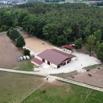
Aussenboxen frei
Schwabach
Margot Witt
@WittMargot
Freizeitstall
Vermieten
Verpachten
Longierzirkel/Roundpen
Reitplatz (z.B. Dressur, Springen, Reining)
Außenboxen
Innenbox
7 weitere...
P

Pferdepension Zimmermann
Schwabach
Dieter Zimmermann
@Dieter_Zimmermann
Freizeitstall
Vermieten
Reitplatz (z.B. Dressur, Springen, Reining)
Sattelkammer/Sattelschränke
Innenbox
4 weitere...
P
Deprecated: Creation of dynamic property Zend_View_Helper_Ads::$adLink is deprecated in /var/www/stall-frei/htdocs/staging.stall-frei.de/library/Psf/View/Helper/Ads.php on line 108

Futtersack HeuToy, Fressbremse in pink
Mechtersen
STALL-FREIde Marketing
@STALL-FREI-Marketing
Stundenlange Beschäftigung die
Koliken vorbeugt, geringe Staubinhalation mit
steuerbarer Futterentnahme


Pferde am Kretschmannshof
Oberasbach
Sebastian Weißkopf
@Pferde-am-Kretschmannshof
Vermieten
Hunde willkommen
Paddock
Offenstall
Halbpension
10 weitere...
P+
Leider kein Vorschaubild
Leider kein Vorschaubild
Boxen für Wallache frei
Schwabach
Freizeitreiter Wolkersdorf
@Buettner_claudia
Freizeitstall
Vermieten
Longierzirkel/Roundpen
Reitplatz (z.B. Dressur, Springen, Reining)
Innenbox
6 weitere...
B
Reitstall Vogel
Nürnberg
Familie-Vogel
@Familie-Vogel
FN-Mitglied
Freizeitstall
Vermieten
Hunde willkommen
Krankenbox
Allergikerstall
Gnadenbrothof
18 weitere...
P

Reitsportanlage Igelsdorf
Rednitzhembach
Christiana Bauer
@Christiana-Bauer
FN-Mitglied
Freizeitstall
Vermieten
Longierzirkel/Roundpen
Ovalbahn
Außenboxen
Innenbox
15 weitere...
P

Pferdehof Schuhmann
Leitelshof
Pferdehof Schuhmann
@Pferdehof-Schuhmann
Freizeitstall
Longierzirkel/Roundpen
Paddock
Innenbox
Vollpension
6 weitere...
P
Leider kein Vorschaubild
Leider kein Vorschaubild
Boxen frei in Unterbaimbach bei Schwabach
Schwabach / Unterbaimbach
V.G.
@V.G.
Freizeitstall
Vermieten
Verpachten
Longierzirkel/Roundpen
Paddock
Hufrehe geeignet
13 weitere...
aktuell
B

Pferdepension Hit Aktivstall Kürmerhof
Hohenkammer
Kuermerhof
@Kuermerhof
*******JETZT NEU MIT ENTSTAUBTEM BIOHEU*********
*******Demnächst mit einem Abenteuerspielplatz für Pferde ( Extrem Trail/Pa

Außenboxen und Offenstall
Schwanstetten
Jasmin Nitsche
@Jassi1211
Pflegepferd
Reitschule
Vermieten
Hunde willkommen
Paddock
Hufrehe geeignet
13 weitere...
aktuell
P
Reitsportzentrum Wendelstein
Wendelstein
Johan-Huber
@Johan-Huber
Pferdeausbildung
Reitlehrer und -unterricht
Longierzirkel/Roundpen
Paddock
Hengsthaltung möglich
Außenbox mit Paddock
Außenboxen
14 weitere...
aktuell
P
Deprecated: Creation of dynamic property Zend_View::$pageCount is deprecated in /var/www/stall-frei/htdocs/staging.stall-frei.de/library/vendor/shardj/zf1-future/library/Zend/View/Abstract.php on line 308
Deprecated: Creation of dynamic property Zend_View::$itemCountPerPage is deprecated in /var/www/stall-frei/htdocs/staging.stall-frei.de/library/vendor/shardj/zf1-future/library/Zend/View/Abstract.php on line 308
Deprecated: Creation of dynamic property Zend_View::$first is deprecated in /var/www/stall-frei/htdocs/staging.stall-frei.de/library/vendor/shardj/zf1-future/library/Zend/View/Abstract.php on line 308
Deprecated: Creation of dynamic property Zend_View::$current is deprecated in /var/www/stall-frei/htdocs/staging.stall-frei.de/library/vendor/shardj/zf1-future/library/Zend/View/Abstract.php on line 308
Deprecated: Creation of dynamic property Zend_View::$last is deprecated in /var/www/stall-frei/htdocs/staging.stall-frei.de/library/vendor/shardj/zf1-future/library/Zend/View/Abstract.php on line 308
Deprecated: Creation of dynamic property Zend_View::$next is deprecated in /var/www/stall-frei/htdocs/staging.stall-frei.de/library/vendor/shardj/zf1-future/library/Zend/View/Abstract.php on line 308
Deprecated: Creation of dynamic property Zend_View::$pagesInRange is deprecated in /var/www/stall-frei/htdocs/staging.stall-frei.de/library/vendor/shardj/zf1-future/library/Zend/View/Abstract.php on line 308
Deprecated: Creation of dynamic property Zend_View::$firstPageInRange is deprecated in /var/www/stall-frei/htdocs/staging.stall-frei.de/library/vendor/shardj/zf1-future/library/Zend/View/Abstract.php on line 308
Deprecated: Creation of dynamic property Zend_View::$lastPageInRange is deprecated in /var/www/stall-frei/htdocs/staging.stall-frei.de/library/vendor/shardj/zf1-future/library/Zend/View/Abstract.php on line 308
Deprecated: Creation of dynamic property Zend_View::$currentItemCount is deprecated in /var/www/stall-frei/htdocs/staging.stall-frei.de/library/vendor/shardj/zf1-future/library/Zend/View/Abstract.php on line 308
Deprecated: Creation of dynamic property Zend_View::$totalItemCount is deprecated in /var/www/stall-frei/htdocs/staging.stall-frei.de/library/vendor/shardj/zf1-future/library/Zend/View/Abstract.php on line 308
Deprecated: Creation of dynamic property Zend_View::$firstItemNumber is deprecated in /var/www/stall-frei/htdocs/staging.stall-frei.de/library/vendor/shardj/zf1-future/library/Zend/View/Abstract.php on line 308
Deprecated: Creation of dynamic property Zend_View::$lastItemNumber is deprecated in /var/www/stall-frei/htdocs/staging.stall-frei.de/library/vendor/shardj/zf1-future/library/Zend/View/Abstract.php on line 308
Deprecated: Creation of dynamic property Zend_View::$router is deprecated in /var/www/stall-frei/htdocs/staging.stall-frei.de/library/vendor/shardj/zf1-future/library/Zend/View/Abstract.php on line 308
Deprecated: Creation of dynamic property Zend_View::$urlParams is deprecated in /var/www/stall-frei/htdocs/staging.stall-frei.de/library/vendor/shardj/zf1-future/library/Zend/View/Abstract.php on line 308
Deprecated: Creation of dynamic property Zend_View::$showAds is deprecated in /var/www/stall-frei/htdocs/staging.stall-frei.de/library/vendor/shardj/zf1-future/library/Zend/View/Abstract.php on line 308
Deprecated: Creation of dynamic property Zend_View::$objectIds is deprecated in /var/www/stall-frei/htdocs/staging.stall-frei.de/library/vendor/shardj/zf1-future/library/Zend/View/Abstract.php on line 308
Deprecated: Creation of dynamic property Zend_View::$showNavbar is deprecated in /var/www/stall-frei/htdocs/staging.stall-frei.de/library/vendor/shardj/zf1-future/library/Zend/View/Abstract.php on line 308
Deprecated: Creation of dynamic property Zend_View::$showBreadcrumb is deprecated in /var/www/stall-frei/htdocs/staging.stall-frei.de/library/vendor/shardj/zf1-future/library/Zend/View/Abstract.php on line 308
Deprecated: Creation of dynamic property Zend_View::$showFooter is deprecated in /var/www/stall-frei/htdocs/staging.stall-frei.de/library/vendor/shardj/zf1-future/library/Zend/View/Abstract.php on line 308
Deprecated: Creation of dynamic property Zend_View::$showInternalAds is deprecated in /var/www/stall-frei/htdocs/staging.stall-frei.de/library/vendor/shardj/zf1-future/library/Zend/View/Abstract.php on line 308
Deprecated: Creation of dynamic property Zend_View::$blNoContent is deprecated in /var/www/stall-frei/htdocs/staging.stall-frei.de/library/vendor/shardj/zf1-future/library/Zend/View/Abstract.php on line 308
Deprecated: Creation of dynamic property Zend_View::$sMetaDesc is deprecated in /var/www/stall-frei/htdocs/staging.stall-frei.de/library/vendor/shardj/zf1-future/library/Zend/View/Abstract.php on line 308
Deprecated: Creation of dynamic property Zend_View::$useGmaps is deprecated in /var/www/stall-frei/htdocs/staging.stall-frei.de/library/vendor/shardj/zf1-future/library/Zend/View/Abstract.php on line 308
Deprecated: Creation of dynamic property Zend_View::$touches is deprecated in /var/www/stall-frei/htdocs/staging.stall-frei.de/library/vendor/shardj/zf1-future/library/Zend/View/Abstract.php on line 308
Deprecated: Creation of dynamic property Zend_View::$oProject is deprecated in /var/www/stall-frei/htdocs/staging.stall-frei.de/library/vendor/shardj/zf1-future/library/Zend/View/Abstract.php on line 308
Deprecated: Creation of dynamic property Zend_View::$pageHeadline is deprecated in /var/www/stall-frei/htdocs/staging.stall-frei.de/library/vendor/shardj/zf1-future/library/Zend/View/Abstract.php on line 308
Deprecated: Creation of dynamic property Zend_View::$disableLocationField is deprecated in /var/www/stall-frei/htdocs/staging.stall-frei.de/library/vendor/shardj/zf1-future/library/Zend/View/Abstract.php on line 308
Deprecated: Creation of dynamic property Zend_View::$isSearch is deprecated in /var/www/stall-frei/htdocs/staging.stall-frei.de/library/vendor/shardj/zf1-future/library/Zend/View/Abstract.php on line 308
Deprecated: Creation of dynamic property Zend_View::$pageTitle is deprecated in /var/www/stall-frei/htdocs/staging.stall-frei.de/library/vendor/shardj/zf1-future/library/Zend/View/Abstract.php on line 308
Deprecated: Creation of dynamic property Psf_Form_Element_Text::$class is deprecated in /var/www/stall-frei/htdocs/staging.stall-frei.de/library/vendor/shardj/zf1-future/library/Zend/Form/Element.php on line 874
Deprecated: Creation of dynamic property Psf_Form_Element_Text::$size is deprecated in /var/www/stall-frei/htdocs/staging.stall-frei.de/library/vendor/shardj/zf1-future/library/Zend/Form/Element.php on line 874
Deprecated: Creation of dynamic property Psf_Form_Element_Text::$placeholder is deprecated in /var/www/stall-frei/htdocs/staging.stall-frei.de/library/vendor/shardj/zf1-future/library/Zend/Form/Element.php on line 874
Deprecated: Creation of dynamic property Psf_Form_Element_Hidden::$class is deprecated in /var/www/stall-frei/htdocs/staging.stall-frei.de/library/vendor/shardj/zf1-future/library/Zend/Form/Element.php on line 874
Deprecated: Creation of dynamic property Psf_Form_Element_Hidden::$class is deprecated in /var/www/stall-frei/htdocs/staging.stall-frei.de/library/vendor/shardj/zf1-future/library/Zend/Form/Element.php on line 874
Deprecated: Creation of dynamic property Psf_Form_Element_Hidden::$class is deprecated in /var/www/stall-frei/htdocs/staging.stall-frei.de/library/vendor/shardj/zf1-future/library/Zend/Form/Element.php on line 874
Deprecated: Creation of dynamic property Psf_Form_Element_Hidden::$class is deprecated in /var/www/stall-frei/htdocs/staging.stall-frei.de/library/vendor/shardj/zf1-future/library/Zend/Form/Element.php on line 874
Deprecated: Creation of dynamic property Psf_Form_Element_Select::$class is deprecated in /var/www/stall-frei/htdocs/staging.stall-frei.de/library/vendor/shardj/zf1-future/library/Zend/Form/Element.php on line 874
Deprecated: Creation of dynamic property Psf_Form_Element_Select::$class is deprecated in /var/www/stall-frei/htdocs/staging.stall-frei.de/library/vendor/shardj/zf1-future/library/Zend/Form/Element.php on line 874
Deprecated: Creation of dynamic property Psf_Form_Element_Select::$class is deprecated in /var/www/stall-frei/htdocs/staging.stall-frei.de/library/vendor/shardj/zf1-future/library/Zend/Form/Element.php on line 874
Deprecated: Creation of dynamic property Psf_Form_Element_Select::$class is deprecated in /var/www/stall-frei/htdocs/staging.stall-frei.de/library/vendor/shardj/zf1-future/library/Zend/Form/Element.php on line 874
Deprecated: Creation of dynamic property Psf_Form_Element_Text::$class is deprecated in /var/www/stall-frei/htdocs/staging.stall-frei.de/library/vendor/shardj/zf1-future/library/Zend/Form/Element.php on line 874
Deprecated: Creation of dynamic property Psf_Form_Element_Checkbox::$label is deprecated in /var/www/stall-frei/htdocs/staging.stall-frei.de/library/vendor/shardj/zf1-future/library/Zend/Form/Element.php on line 874
Deprecated: Creation of dynamic property Zend_View::$sort is deprecated in /var/www/stall-frei/htdocs/staging.stall-frei.de/library/vendor/shardj/zf1-future/library/Zend/View/Abstract.php on line 308
Deprecated: Creation of dynamic property Zend_View::$searchLocation is deprecated in /var/www/stall-frei/htdocs/staging.stall-frei.de/library/vendor/shardj/zf1-future/library/Zend/View/Abstract.php on line 308
Deprecated: Creation of dynamic property Zend_View::$locationHint is deprecated in /var/www/stall-frei/htdocs/staging.stall-frei.de/library/vendor/shardj/zf1-future/library/Zend/View/Abstract.php on line 308
Psf_GeoCoder_Abstract::getLocation: Wolkersdorf Get Location CachedOrLive
Psf_GeoCoder_Abstract::getCachedOrLive: Wolkersdorf
Psf_GeoCoder_OpenCageData::makeApiRequest: response:
Array
(
[documentation] => https://opencagedata.com/api
[licenses] => Array
(
[0] => Array
(
[name] => see attribution guide
[url] => https://opencagedata.com/credits
)
)
[results] => Array
(
[0] => Array
(
[bounds] => Array
(
[northeast] => Array
(
[lat] => 49.3820291
[lng] => 11.0483533
)
[southwest] => Array
(
[lat] => 49.3420291
[lng] => 11.0083533
)
)
[components] => Array
(
[ISO_3166-1_alpha-2] => DE
[ISO_3166-1_alpha-3] => DEU
[ISO_3166-2] => Array
(
[0] => DE-BY
)
[_category] => place
[_normalized_city] => Schwabach
[_type] => village
[continent] => Europe
[country] => Deutschland
[country_code] => de
[political_union] => European Union
[postcode] => 90453
[state] => Bayern
[state_code] => BY
[town] => Schwabach
[village] => Wolkersdorf
)
[confidence] => 7
[formatted] => 90453 Wolkersdorf, Deutschland
[geometry] => Array
(
[lat] => 49.3620291
[lng] => 11.0283533
)
)
[1] => Array
(
[bounds] => Array
(
[northeast] => Array
(
[lat] => 47.8973341
[lng] => 12.63132
)
[southwest] => Array
(
[lat] => 47.8619392
[lng] => 12.5785909
)
)
[components] => Array
(
[ISO_3166-1_alpha-2] => DE
[ISO_3166-1_alpha-3] => DEU
[ISO_3166-2] => Array
(
[0] => DE-BY
)
[_category] => place
[_normalized_city] => Traunstein
[_type] => city
[continent] => Europe
[country] => Deutschland
[country_code] => de
[county] => Landkreis Traunstein
[political_union] => European Union
[state] => Bayern
[state_code] => BY
[town] => Traunstein
)
[confidence] => 7
[formatted] => Traunstein, Bayern, Deutschland
[geometry] => Array
(
[lat] => 47.8798793
[lng] => 12.6074324
)
)
[2] => Array
(
[bounds] => Array
(
[northeast] => Array
(
[lat] => 47.9719623
[lng] => 12.798817
)
[southwest] => Array
(
[lat] => 47.9319623
[lng] => 12.758817
)
)
[components] => Array
(
[ISO_3166-1_alpha-2] => DE
[ISO_3166-1_alpha-3] => DEU
[ISO_3166-2] => Array
(
[0] => DE-BY
)
[_category] => place
[_normalized_city] => Kirchanschöring
[_type] => hamlet
[continent] => Europe
[country] => Deutschland
[country_code] => de
[county] => Landkreis Traunstein
[hamlet] => Wolkersdorf
[political_union] => European Union
[postcode] => 83417
[state] => Bayern
[state_code] => BY
[village] => Kirchanschöring
)
[confidence] => 7
[formatted] => Wolkersdorf, 83417 Kirchanschöring, Deutschland
[geometry] => Array
(
[lat] => 47.9519623
[lng] => 12.778817
)
)
[3] => Array
(
[bounds] => Array
(
[northeast] => Array
(
[lat] => 49.7903268
[lng] => 11.7319309
)
[southwest] => Array
(
[lat] => 49.7503268
[lng] => 11.6919309
)
)
[components] => Array
(
[ISO_3166-1_alpha-2] => DE
[ISO_3166-1_alpha-3] => DEU
[ISO_3166-2] => Array
(
[0] => DE-BY
)
[_category] => place
[_normalized_city] => Kirchenthumbach
[_type] => city
[city] => Kirchenthumbach
[continent] => Europe
[country] => Deutschland
[country_code] => de
[county] => Landkreis Neustadt an der Waldnaab
[municipality] => Kirchenthumbach (VGem)
[political_union] => European Union
[postcode] => 91281
[state] => Bayern
[state_code] => BY
)
[confidence] => 7
[formatted] => Kirchenthumbach, Bayern, Deutschland
[geometry] => Array
(
[lat] => 49.7703268
[lng] => 11.7119309
)
)
[4] => Array
(
[bounds] => Array
(
[northeast] => Array
(
[lat] => 47.9533187
[lng] => 12.7779382
)
[southwest] => Array
(
[lat] => 47.9522451
[lng] => 12.7768832
)
)
[components] => Array
(
[ISO_3166-1_alpha-2] => DE
[ISO_3166-1_alpha-3] => DEU
[ISO_3166-2] => Array
(
[0] => DE-BY
)
[_category] => road
[_normalized_city] => Kirchanschöring
[_type] => road
[continent] => Europe
[country] => Deutschland
[country_code] => de
[county] => Landkreis Traunstein
[hamlet] => Wolkersdorf
[political_union] => European Union
[postcode] => 83417
[road] => Wolkersdorf
[road_type] => residential
[state] => Bayern
[state_code] => BY
[village] => Kirchanschöring
)
[confidence] => 9
[formatted] => Wolkersdorf, 83417 Kirchanschöring, Deutschland
[geometry] => Array
(
[lat] => 47.9526896
[lng] => 12.7773034
)
)
[5] => Array
(
[bounds] => Array
(
[northeast] => Array
(
[lat] => 49.1811335
[lng] => 12.9217137
)
[southwest] => Array
(
[lat] => 49.1411335
[lng] => 12.8817137
)
)
[components] => Array
(
[ISO_3166-1_alpha-2] => DE
[ISO_3166-1_alpha-3] => DEU
[ISO_3166-2] => Array
(
[0] => DE-BY
)
[_category] => place
[_normalized_city] => Bad Kötzting
[_type] => hamlet
[continent] => Europe
[country] => Deutschland
[country_code] => de
[county] => Landkreis Cham
[hamlet] => Wölkersdorf
[municipality] => Bad Kötzting
[political_union] => European Union
[postcode] => 93479
[state] => Bayern
[state_code] => BY
)
[confidence] => 7
[formatted] => Wölkersdorf, 93479 Bad Kötzting, Deutschland
[geometry] => Array
(
[lat] => 49.1611335
[lng] => 12.9017137
)
)
[6] => Array
(
[components] => Array
(
[ISO_3166-1_alpha-2] => FR
[ISO_3166-1_alpha-3] => FRA
[ISO_3166-2] => Array
(
[0] => FR-GES
[1] => FR-6AE
[2] => FR-68
)
[_category] => place
[_normalized_city] => Wolfersdorf
[_type] => city
[city] => Wolfersdorf
[continent] => Europe
[country] => France
[country_code] => fr
[county] => Haut-Rhin
[local_authority] => Communauté de communes Sud Alsace Largue
[political_union] => European Union
[postcode] => 68210
[state] => Grand Est
[state_code] => GES
)
[confidence] => 3
[formatted] => Wolfersdorf, Haut-Rhin, France
[geometry] => Array
(
[lat] => 47.637704
[lng] => 7.110948
)
)
[7] => Array
(
[components] => Array
(
[ISO_3166-1_alpha-2] => FR
[ISO_3166-1_alpha-3] => FRA
[ISO_3166-2] => Array
(
[0] => FR-GES
[1] => FR-6AE
[2] => FR-68
)
[_category] => road
[_normalized_city] => Wolfersdorf
[_type] => road
[city] => Wolfersdorf
[continent] => Europe
[country] => France
[country_code] => fr
[county] => Haut-Rhin
[local_authority] => Communauté de communes Sud Alsace Largue
[political_union] => European Union
[postcode] => 68210
[road] => Rue de la Largue
[state] => Grand Est
[state_code] => GES
)
[confidence] => 2
[formatted] => Rue de la Largue, 68210 Wolfersdorf, France
[geometry] => Array
(
[lat] => 47.63736
[lng] => 7.11436
)
)
[8] => Array
(
[components] => Array
(
[ISO_3166-1_alpha-2] => FR
[ISO_3166-1_alpha-3] => FRA
[ISO_3166-2] => Array
(
[0] => FR-GES
[1] => FR-6AE
[2] => FR-68
)
[_category] => road
[_normalized_city] => Wolfersdorf
[_type] => road
[city] => Wolfersdorf
[continent] => Europe
[country] => France
[country_code] => fr
[county] => Haut-Rhin
[local_authority] => Communauté de communes Sud Alsace Largue
[political_union] => European Union
[postcode] => 68210
[road] => Impasse de la Grange
[state] => Grand Est
[state_code] => GES
)
[confidence] => 2
[formatted] => Impasse de la Grange, 68210 Wolfersdorf, France
[geometry] => Array
(
[lat] => 47.637648
[lng] => 7.110364
)
)
[9] => Array
(
[components] => Array
(
[ISO_3166-1_alpha-2] => FR
[ISO_3166-1_alpha-3] => FRA
[ISO_3166-2] => Array
(
[0] => FR-GES
[1] => FR-6AE
[2] => FR-68
)
[_category] => road
[_normalized_city] => Wolfersdorf
[_type] => road
[city] => Wolfersdorf
[continent] => Europe
[country] => France
[country_code] => fr
[county] => Haut-Rhin
[local_authority] => Communauté de communes Sud Alsace Largue
[political_union] => European Union
[postcode] => 68210
[road] => Rue du Canal
[state] => Grand Est
[state_code] => GES
)
[confidence] => 2
[formatted] => Rue du Canal, 68210 Wolfersdorf, France
[geometry] => Array
(
[lat] => 47.636243
[lng] => 7.109848
)
)
)
[status] => Array
(
[code] => 200
[message] => OK
)
[stay_informed] => Array
(
[blog] => https://blog.opencagedata.com
[mastodon] => https://en.osm.town/@opencage
)
[thanks] => For using an OpenCage API
[timestamp] => Array
(
[created_http] => Sat, 07 Feb 2026 16:03:19 GMT
[created_unix] => 1770480199
)
[total_results] => 10
)
Psf_GeoCoder_Abstract::convertLocationResult
{"documentation":"https:\/\/opencagedata.com\/api","licenses":[{"name":"see attribution guide","url":"https:\/\/opencagedata.com\/credits"}],"results":[{"bounds":{"northeast":{"lat":49.3820291,"lng":11.0483533},"southwest":{"lat":49.3420291,"lng":11.0083533}},"components":{"ISO_3166-1_alpha-2":"DE","ISO_3166-1_alpha-3":"DEU","ISO_3166-2":["DE-BY"],"_category":"place","_normalized_city":"Schwabach","_type":"village","continent":"Europe","country":"Deutschland","country_code":"de","political_union":"European Union","postcode":"90453","state":"Bayern","state_code":"BY","town":"Schwabach","village":"Wolkersdorf"},"confidence":7,"formatted":"90453 Wolkersdorf, Deutschland","geometry":{"lat":49.3620291,"lng":11.0283533}},{"bounds":{"northeast":{"lat":47.8973341,"lng":12.63132},"southwest":{"lat":47.8619392,"lng":12.5785909}},"components":{"ISO_3166-1_alpha-2":"DE","ISO_3166-1_alpha-3":"DEU","ISO_3166-2":["DE-BY"],"_category":"place","_normalized_city":"Traunstein","_type":"city","continent":"Europe","country":"Deutschland","country_code":"de","county":"Landkreis Traunstein","political_union":"European Union","state":"Bayern","state_code":"BY","town":"Traunstein"},"confidence":7,"formatted":"Traunstein, Bayern, Deutschland","geometry":{"lat":47.8798793,"lng":12.6074324}},{"bounds":{"northeast":{"lat":47.9719623,"lng":12.798817},"southwest":{"lat":47.9319623,"lng":12.758817}},"components":{"ISO_3166-1_alpha-2":"DE","ISO_3166-1_alpha-3":"DEU","ISO_3166-2":["DE-BY"],"_category":"place","_normalized_city":"Kirchansch\u00f6ring","_type":"hamlet","continent":"Europe","country":"Deutschland","country_code":"de","county":"Landkreis Traunstein","hamlet":"Wolkersdorf","political_union":"European Union","postcode":"83417","state":"Bayern","state_code":"BY","village":"Kirchansch\u00f6ring"},"confidence":7,"formatted":"Wolkersdorf, 83417 Kirchansch\u00f6ring, Deutschland","geometry":{"lat":47.9519623,"lng":12.778817}},{"bounds":{"northeast":{"lat":49.7903268,"lng":11.7319309},"southwest":{"lat":49.7503268,"lng":11.6919309}},"components":{"ISO_3166-1_alpha-2":"DE","ISO_3166-1_alpha-3":"DEU","ISO_3166-2":["DE-BY"],"_category":"place","_normalized_city":"Kirchenthumbach","_type":"city","city":"Kirchenthumbach","continent":"Europe","country":"Deutschland","country_code":"de","county":"Landkreis Neustadt an der Waldnaab","municipality":"Kirchenthumbach (VGem)","political_union":"European Union","postcode":"91281","state":"Bayern","state_code":"BY"},"confidence":7,"formatted":"Kirchenthumbach, Bayern, Deutschland","geometry":{"lat":49.7703268,"lng":11.7119309}},{"bounds":{"northeast":{"lat":47.9533187,"lng":12.7779382},"southwest":{"lat":47.9522451,"lng":12.7768832}},"components":{"ISO_3166-1_alpha-2":"DE","ISO_3166-1_alpha-3":"DEU","ISO_3166-2":["DE-BY"],"_category":"road","_normalized_city":"Kirchansch\u00f6ring","_type":"road","continent":"Europe","country":"Deutschland","country_code":"de","county":"Landkreis Traunstein","hamlet":"Wolkersdorf","political_union":"European Union","postcode":"83417","road":"Wolkersdorf","road_type":"residential","state":"Bayern","state_code":"BY","village":"Kirchansch\u00f6ring"},"confidence":9,"formatted":"Wolkersdorf, 83417 Kirchansch\u00f6ring, Deutschland","geometry":{"lat":47.9526896,"lng":12.7773034}},{"bounds":{"northeast":{"lat":49.1811335,"lng":12.9217137},"southwest":{"lat":49.1411335,"lng":12.8817137}},"components":{"ISO_3166-1_alpha-2":"DE","ISO_3166-1_alpha-3":"DEU","ISO_3166-2":["DE-BY"],"_category":"place","_normalized_city":"Bad K\u00f6tzting","_type":"hamlet","continent":"Europe","country":"Deutschland","country_code":"de","county":"Landkreis Cham","hamlet":"W\u00f6lkersdorf","municipality":"Bad K\u00f6tzting","political_union":"European Union","postcode":"93479","state":"Bayern","state_code":"BY"},"confidence":7,"formatted":"W\u00f6lkersdorf, 93479 Bad K\u00f6tzting, Deutschland","geometry":{"lat":49.1611335,"lng":12.9017137}},{"components":{"ISO_3166-1_alpha-2":"FR","ISO_3166-1_alpha-3":"FRA","ISO_3166-2":["FR-GES","FR-6AE","FR-68"],"_category":"place","_normalized_city":"Wolfersdorf","_type":"city","city":"Wolfersdorf","continent":"Europe","country":"France","country_code":"fr","county":"Haut-Rhin","local_authority":"Communaut\u00e9 de communes Sud Alsace Largue","political_union":"European Union","postcode":"68210","state":"Grand Est","state_code":"GES"},"confidence":3,"formatted":"Wolfersdorf, Haut-Rhin, France","geometry":{"lat":47.637704,"lng":7.110948}},{"components":{"ISO_3166-1_alpha-2":"FR","ISO_3166-1_alpha-3":"FRA","ISO_3166-2":["FR-GES","FR-6AE","FR-68"],"_category":"road","_normalized_city":"Wolfersdorf","_type":"road","city":"Wolfersdorf","continent":"Europe","country":"France","country_code":"fr","county":"Haut-Rhin","local_authority":"Communaut\u00e9 de communes Sud Alsace Largue","political_union":"European Union","postcode":"68210","road":"Rue de la Largue","state":"Grand Est","state_code":"GES"},"confidence":2,"formatted":"Rue de la Largue, 68210 Wolfersdorf, France","geometry":{"lat":47.63736,"lng":7.11436}},{"components":{"ISO_3166-1_alpha-2":"FR","ISO_3166-1_alpha-3":"FRA","ISO_3166-2":["FR-GES","FR-6AE","FR-68"],"_category":"road","_normalized_city":"Wolfersdorf","_type":"road","city":"Wolfersdorf","continent":"Europe","country":"France","country_code":"fr","county":"Haut-Rhin","local_authority":"Communaut\u00e9 de communes Sud Alsace Largue","political_union":"European Union","postcode":"68210","road":"Impasse de la Grange","state":"Grand Est","state_code":"GES"},"confidence":2,"formatted":"Impasse de la Grange, 68210 Wolfersdorf, France","geometry":{"lat":47.637648,"lng":7.110364}},{"components":{"ISO_3166-1_alpha-2":"FR","ISO_3166-1_alpha-3":"FRA","ISO_3166-2":["FR-GES","FR-6AE","FR-68"],"_category":"road","_normalized_city":"Wolfersdorf","_type":"road","city":"Wolfersdorf","continent":"Europe","country":"France","country_code":"fr","county":"Haut-Rhin","local_authority":"Communaut\u00e9 de communes Sud Alsace Largue","political_union":"European Union","postcode":"68210","road":"Rue du Canal","state":"Grand Est","state_code":"GES"},"confidence":2,"formatted":"Rue du Canal, 68210 Wolfersdorf, France","geometry":{"lat":47.636243,"lng":7.109848}}],"status":{"code":200,"message":"OK"},"stay_informed":{"blog":"https:\/\/blog.opencagedata.com","mastodon":"https:\/\/en.osm.town\/@opencage"},"thanks":"For using an OpenCage API","timestamp":{"created_http":"Sat, 07 Feb 2026 16:03:19 GMT","created_unix":1770480199},"total_results":10}Array
(
[0] => stdClass Object
(
[bounds] => stdClass Object
(
[northeast] => stdClass Object
(
[lat] => 49.3820291
[lng] => 11.0483533
)
[southwest] => stdClass Object
(
[lat] => 49.3420291
[lng] => 11.0083533
)
)
[components] => stdClass Object
(
[ISO_3166-1_alpha-2] => DE
[ISO_3166-1_alpha-3] => DEU
[ISO_3166-2] => Array
(
[0] => DE-BY
)
[_category] => place
[_normalized_city] => Schwabach
[_type] => village
[continent] => Europe
[country] => Deutschland
[country_code] => de
[political_union] => European Union
[postcode] => 90453
[state] => Bayern
[state_code] => BY
[town] => Schwabach
[village] => Wolkersdorf
)
[confidence] => 7
[formatted] => 90453 Wolkersdorf, Deutschland
[geometry] => stdClass Object
(
[lat] => 49.3620291
[lng] => 11.0283533
)
)
[1] => stdClass Object
(
[bounds] => stdClass Object
(
[northeast] => stdClass Object
(
[lat] => 47.8973341
[lng] => 12.63132
)
[southwest] => stdClass Object
(
[lat] => 47.8619392
[lng] => 12.5785909
)
)
[components] => stdClass Object
(
[ISO_3166-1_alpha-2] => DE
[ISO_3166-1_alpha-3] => DEU
[ISO_3166-2] => Array
(
[0] => DE-BY
)
[_category] => place
[_normalized_city] => Traunstein
[_type] => city
[continent] => Europe
[country] => Deutschland
[country_code] => de
[county] => Landkreis Traunstein
[political_union] => European Union
[state] => Bayern
[state_code] => BY
[town] => Traunstein
)
[confidence] => 7
[formatted] => Traunstein, Bayern, Deutschland
[geometry] => stdClass Object
(
[lat] => 47.8798793
[lng] => 12.6074324
)
)
[2] => stdClass Object
(
[bounds] => stdClass Object
(
[northeast] => stdClass Object
(
[lat] => 47.9719623
[lng] => 12.798817
)
[southwest] => stdClass Object
(
[lat] => 47.9319623
[lng] => 12.758817
)
)
[components] => stdClass Object
(
[ISO_3166-1_alpha-2] => DE
[ISO_3166-1_alpha-3] => DEU
[ISO_3166-2] => Array
(
[0] => DE-BY
)
[_category] => place
[_normalized_city] => Kirchanschöring
[_type] => hamlet
[continent] => Europe
[country] => Deutschland
[country_code] => de
[county] => Landkreis Traunstein
[hamlet] => Wolkersdorf
[political_union] => European Union
[postcode] => 83417
[state] => Bayern
[state_code] => BY
[village] => Kirchanschöring
)
[confidence] => 7
[formatted] => Wolkersdorf, 83417 Kirchanschöring, Deutschland
[geometry] => stdClass Object
(
[lat] => 47.9519623
[lng] => 12.778817
)
)
[3] => stdClass Object
(
[bounds] => stdClass Object
(
[northeast] => stdClass Object
(
[lat] => 49.7903268
[lng] => 11.7319309
)
[southwest] => stdClass Object
(
[lat] => 49.7503268
[lng] => 11.6919309
)
)
[components] => stdClass Object
(
[ISO_3166-1_alpha-2] => DE
[ISO_3166-1_alpha-3] => DEU
[ISO_3166-2] => Array
(
[0] => DE-BY
)
[_category] => place
[_normalized_city] => Kirchenthumbach
[_type] => city
[city] => Kirchenthumbach
[continent] => Europe
[country] => Deutschland
[country_code] => de
[county] => Landkreis Neustadt an der Waldnaab
[municipality] => Kirchenthumbach (VGem)
[political_union] => European Union
[postcode] => 91281
[state] => Bayern
[state_code] => BY
)
[confidence] => 7
[formatted] => Kirchenthumbach, Bayern, Deutschland
[geometry] => stdClass Object
(
[lat] => 49.7703268
[lng] => 11.7119309
)
)
[4] => stdClass Object
(
[bounds] => stdClass Object
(
[northeast] => stdClass Object
(
[lat] => 47.9533187
[lng] => 12.7779382
)
[southwest] => stdClass Object
(
[lat] => 47.9522451
[lng] => 12.7768832
)
)
[components] => stdClass Object
(
[ISO_3166-1_alpha-2] => DE
[ISO_3166-1_alpha-3] => DEU
[ISO_3166-2] => Array
(
[0] => DE-BY
)
[_category] => road
[_normalized_city] => Kirchanschöring
[_type] => road
[continent] => Europe
[country] => Deutschland
[country_code] => de
[county] => Landkreis Traunstein
[hamlet] => Wolkersdorf
[political_union] => European Union
[postcode] => 83417
[road] => Wolkersdorf
[road_type] => residential
[state] => Bayern
[state_code] => BY
[village] => Kirchanschöring
)
[confidence] => 9
[formatted] => Wolkersdorf, 83417 Kirchanschöring, Deutschland
[geometry] => stdClass Object
(
[lat] => 47.9526896
[lng] => 12.7773034
)
)
[5] => stdClass Object
(
[bounds] => stdClass Object
(
[northeast] => stdClass Object
(
[lat] => 49.1811335
[lng] => 12.9217137
)
[southwest] => stdClass Object
(
[lat] => 49.1411335
[lng] => 12.8817137
)
)
[components] => stdClass Object
(
[ISO_3166-1_alpha-2] => DE
[ISO_3166-1_alpha-3] => DEU
[ISO_3166-2] => Array
(
[0] => DE-BY
)
[_category] => place
[_normalized_city] => Bad Kötzting
[_type] => hamlet
[continent] => Europe
[country] => Deutschland
[country_code] => de
[county] => Landkreis Cham
[hamlet] => Wölkersdorf
[municipality] => Bad Kötzting
[political_union] => European Union
[postcode] => 93479
[state] => Bayern
[state_code] => BY
)
[confidence] => 7
[formatted] => Wölkersdorf, 93479 Bad Kötzting, Deutschland
[geometry] => stdClass Object
(
[lat] => 49.1611335
[lng] => 12.9017137
)
)
[6] => stdClass Object
(
[components] => stdClass Object
(
[ISO_3166-1_alpha-2] => FR
[ISO_3166-1_alpha-3] => FRA
[ISO_3166-2] => Array
(
[0] => FR-GES
[1] => FR-6AE
[2] => FR-68
)
[_category] => place
[_normalized_city] => Wolfersdorf
[_type] => city
[city] => Wolfersdorf
[continent] => Europe
[country] => France
[country_code] => fr
[county] => Haut-Rhin
[local_authority] => Communauté de communes Sud Alsace Largue
[political_union] => European Union
[postcode] => 68210
[state] => Grand Est
[state_code] => GES
)
[confidence] => 3
[formatted] => Wolfersdorf, Haut-Rhin, France
[geometry] => stdClass Object
(
[lat] => 47.637704
[lng] => 7.110948
)
)
[7] => stdClass Object
(
[components] => stdClass Object
(
[ISO_3166-1_alpha-2] => FR
[ISO_3166-1_alpha-3] => FRA
[ISO_3166-2] => Array
(
[0] => FR-GES
[1] => FR-6AE
[2] => FR-68
)
[_category] => road
[_normalized_city] => Wolfersdorf
[_type] => road
[city] => Wolfersdorf
[continent] => Europe
[country] => France
[country_code] => fr
[county] => Haut-Rhin
[local_authority] => Communauté de communes Sud Alsace Largue
[political_union] => European Union
[postcode] => 68210
[road] => Rue de la Largue
[state] => Grand Est
[state_code] => GES
)
[confidence] => 2
[formatted] => Rue de la Largue, 68210 Wolfersdorf, France
[geometry] => stdClass Object
(
[lat] => 47.63736
[lng] => 7.11436
)
)
[8] => stdClass Object
(
[components] => stdClass Object
(
[ISO_3166-1_alpha-2] => FR
[ISO_3166-1_alpha-3] => FRA
[ISO_3166-2] => Array
(
[0] => FR-GES
[1] => FR-6AE
[2] => FR-68
)
[_category] => road
[_normalized_city] => Wolfersdorf
[_type] => road
[city] => Wolfersdorf
[continent] => Europe
[country] => France
[country_code] => fr
[county] => Haut-Rhin
[local_authority] => Communauté de communes Sud Alsace Largue
[political_union] => European Union
[postcode] => 68210
[road] => Impasse de la Grange
[state] => Grand Est
[state_code] => GES
)
[confidence] => 2
[formatted] => Impasse de la Grange, 68210 Wolfersdorf, France
[geometry] => stdClass Object
(
[lat] => 47.637648
[lng] => 7.110364
)
)
[9] => stdClass Object
(
[components] => stdClass Object
(
[ISO_3166-1_alpha-2] => FR
[ISO_3166-1_alpha-3] => FRA
[ISO_3166-2] => Array
(
[0] => FR-GES
[1] => FR-6AE
[2] => FR-68
)
[_category] => road
[_normalized_city] => Wolfersdorf
[_type] => road
[city] => Wolfersdorf
[continent] => Europe
[country] => France
[country_code] => fr
[county] => Haut-Rhin
[local_authority] => Communauté de communes Sud Alsace Largue
[political_union] => European Union
[postcode] => 68210
[road] => Rue du Canal
[state] => Grand Est
[state_code] => GES
)
[confidence] => 2
[formatted] => Rue du Canal, 68210 Wolfersdorf, France
[geometry] => stdClass Object
(
[lat] => 47.636243
[lng] => 7.109848
)
)
)
Psf_GeoCoder_OpenCageData::getKeyMap: 0
stdClass Object
(
    [bounds] => stdClass Object
        (
            [northeast] => stdClass Object
                (
                    [lat] => 49.3820291
                    [lng] => 11.0483533
                )

            [southwest] => stdClass Object
                (
                    [lat] => 49.3420291
                    [lng] => 11.0083533
                )

        )

    [components] => stdClass Object
        (
            [ISO_3166-1_alpha-2] => DE
            [ISO_3166-1_alpha-3] => DEU
            [ISO_3166-2] => Array
                (
                    [0] => DE-BY
                )

            [_category] => place
            [_normalized_city] => Schwabach
            [_type] => village
            [continent] => Europe
            [country] => Deutschland
            [country_code] => de
            [political_union] => European Union
            [postcode] => 90453
            [state] => Bayern
            [state_code] => BY
            [town] => Schwabach
            [village] => Wolkersdorf
        )

    [confidence] => 7
    [formatted] => 90453 Wolkersdorf, Deutschland
    [geometry] => stdClass Object
        (
            [lat] => 49.3620291
            [lng] => 11.0283533
        )

)
Psf_GeoCoder_OpenCageData::getCounty:
Psf_GeoCoder_OpenCageData::addMissingData REFETCH!
Array
(
    [address] => 90453 Wolkersdorf, Deutschland
    [type] => village
    [street] =>
    [city] => Schwabach
    [county] =>
    [state] => Bayern
    [zip] => 90453
    [country] => Deutschland
    [suburb] =>
    [countrycode] => de
    [latitude] => 49.3620291
    [longitude] => 11.0283533
    [accuracy] => 1
    [confidence] => 7
    [bounds] => stdClass Object
        (
            [northeast] => stdClass Object
                (
                    [lat] => 49.3820291
                    [lng] => 11.0483533
                )

            [southwest] => stdClass Object
                (
                    [lat] => 49.3420291
                    [lng] => 11.0083533
                )

        )

)
reformat!
Array
(
    [address] => 90453 Schwabach
    [type] => village
    [street] =>
    [city] => Schwabach
    [county] =>
    [state] => Bayern
    [zip] => 90453
    [country] => Deutschland
    [suburb] =>
    [countrycode] => de
    [latitude] => 49.3620291
    [longitude] => 11.0283533
    [accuracy] => 1
    [confidence] => 7
    [bounds] => stdClass Object
        (
            [northeast] => stdClass Object
                (
                    [lat] => 49.3820291
                    [lng] => 11.0483533
                )

            [southwest] => stdClass Object
                (
                    [lat] => 49.3420291
                    [lng] => 11.0083533
                )

        )

    [place] => 90453 Schwabach, Bayern
    [hash] => b8e20290ce5331fdb30f4efb8e3aab2a
)
Psf_GeoCoder_OpenCageData::getKeyMap: 1
stdClass Object
(
    [bounds] => stdClass Object
        (
            [northeast] => stdClass Object
                (
                    [lat] => 47.8973341
                    [lng] => 12.63132
                )

            [southwest] => stdClass Object
                (
                    [lat] => 47.8619392
                    [lng] => 12.5785909
                )

        )

    [components] => stdClass Object
        (
            [ISO_3166-1_alpha-2] => DE
            [ISO_3166-1_alpha-3] => DEU
            [ISO_3166-2] => Array
                (
                    [0] => DE-BY
                )

            [_category] => place
            [_normalized_city] => Traunstein
            [_type] => city
            [continent] => Europe
            [country] => Deutschland
            [country_code] => de
            [county] => Landkreis Traunstein
            [political_union] => European Union
            [state] => Bayern
            [state_code] => BY
            [town] => Traunstein
        )

    [confidence] => 7
    [formatted] => Traunstein, Bayern, Deutschland
    [geometry] => stdClass Object
        (
            [lat] => 47.8798793
            [lng] => 12.6074324
        )

)
Psf_GeoCoder_OpenCageData::getCounty: Traunstein
Psf_GeoCoder_OpenCageData::addMissingData REFETCH!
Array
(
    [address] => Traunstein, Bayern, Deutschland
    [type] => city
    [street] =>
    [city] => Traunstein
    [county] => Traunstein
    [state] => Bayern
    [zip] =>
    [country] => Deutschland
    [suburb] =>
    [countrycode] => de
    [latitude] => 47.8798793
    [longitude] => 12.6074324
    [accuracy] => 1
    [confidence] => 7
    [bounds] => stdClass Object
        (
            [northeast] => stdClass Object
                (
                    [lat] => 47.8973341
                    [lng] => 12.63132
                )

            [southwest] => stdClass Object
                (
                    [lat] => 47.8619392
                    [lng] => 12.5785909
                )

        )

)
reformat!
Array
(
    [address] => Traunstein, Bayern, Deutschland
    [type] => city
    [street] =>
    [city] => Traunstein
    [county] => Traunstein
    [state] => Bayern
    [zip] =>
    [country] => Deutschland
    [suburb] =>
    [countrycode] => de
    [latitude] => 47.8798793
    [longitude] => 12.6074324
    [accuracy] => 1
    [confidence] => 7
    [bounds] => stdClass Object
        (
            [northeast] => stdClass Object
                (
                    [lat] => 47.8973341
                    [lng] => 12.63132
                )

            [southwest] => stdClass Object
                (
                    [lat] => 47.8619392
                    [lng] => 12.5785909
                )

        )

    [place] => Traunstein, Bayern
    [hash] => 702027a59d8b264be3baef5760e3b37d
)
Psf_GeoCoder_OpenCageData::getKeyMap: 2
stdClass Object
(
    [bounds] => stdClass Object
        (
            [northeast] => stdClass Object
                (
                    [lat] => 47.9719623
                    [lng] => 12.798817
                )

            [southwest] => stdClass Object
                (
                    [lat] => 47.9319623
                    [lng] => 12.758817
                )

        )

    [components] => stdClass Object
        (
            [ISO_3166-1_alpha-2] => DE
            [ISO_3166-1_alpha-3] => DEU
            [ISO_3166-2] => Array
                (
                    [0] => DE-BY
                )

            [_category] => place
            [_normalized_city] => Kirchanschöring
            [_type] => hamlet
            [continent] => Europe
            [country] => Deutschland
            [country_code] => de
            [county] => Landkreis Traunstein
            [hamlet] => Wolkersdorf
            [political_union] => European Union
            [postcode] => 83417
            [state] => Bayern
            [state_code] => BY
            [village] => Kirchanschöring
        )

    [confidence] => 7
    [formatted] => Wolkersdorf, 83417 Kirchanschöring, Deutschland
    [geometry] => stdClass Object
        (
            [lat] => 47.9519623
            [lng] => 12.778817
        )

)
Psf_GeoCoder_OpenCageData::getCounty: Traunstein
Psf_GeoCoder_OpenCageData::addMissingData REFETCH!
Array
(
    [address] => Wolkersdorf, 83417 Kirchanschöring, Deutschland
    [type] => hamlet
    [street] => Wolkersdorf
    [city] => Kirchanschöring
    [county] => Traunstein
    [state] => Bayern
    [zip] => 83417
    [country] => Deutschland
    [suburb] =>
    [countrycode] => de
    [latitude] => 47.9519623
    [longitude] => 12.778817
    [accuracy] => 1
    [confidence] => 7
    [bounds] => stdClass Object
        (
            [northeast] => stdClass Object
                (
                    [lat] => 47.9719623
                    [lng] => 12.798817
                )

            [southwest] => stdClass Object
                (
                    [lat] => 47.9319623
                    [lng] => 12.758817
                )

        )

)
reformat!
Array
(
    [address] => Wolkersdorf, 83417 Kirchanschöring, Deutschland
    [type] => hamlet
    [street] => Wolkersdorf
    [city] => Kirchanschöring
    [county] => Traunstein
    [state] => Bayern
    [zip] => 83417
    [country] => Deutschland
    [suburb] =>
    [countrycode] => de
    [latitude] => 47.9519623
    [longitude] => 12.778817
    [accuracy] => 1
    [confidence] => 7
    [bounds] => stdClass Object
        (
            [northeast] => stdClass Object
                (
                    [lat] => 47.9719623
                    [lng] => 12.798817
                )

            [southwest] => stdClass Object
                (
                    [lat] => 47.9319623
                    [lng] => 12.758817
                )

        )

    [place] => Wolkersdorf, 83417 Kirchanschöring, Bayern
    [hash] => f1f42bc78130544122f4aa70a5de6f1f
)
Psf_GeoCoder_OpenCageData::getKeyMap: 3
stdClass Object
(
    [bounds] => stdClass Object
        (
            [northeast] => stdClass Object
                (
                    [lat] => 49.7903268
                    [lng] => 11.7319309
                )

            [southwest] => stdClass Object
                (
                    [lat] => 49.7503268
                    [lng] => 11.6919309
                )

        )

    [components] => stdClass Object
        (
            [ISO_3166-1_alpha-2] => DE
            [ISO_3166-1_alpha-3] => DEU
            [ISO_3166-2] => Array
                (
                    [0] => DE-BY
                )

            [_category] => place
            [_normalized_city] => Kirchenthumbach
            [_type] => city
            [city] => Kirchenthumbach
            [continent] => Europe
            [country] => Deutschland
            [country_code] => de
            [county] => Landkreis Neustadt an der Waldnaab
            [municipality] => Kirchenthumbach (VGem)
            [political_union] => European Union
            [postcode] => 91281
            [state] => Bayern
            [state_code] => BY
        )

    [confidence] => 7
    [formatted] => Kirchenthumbach, Bayern, Deutschland
    [geometry] => stdClass Object
        (
            [lat] => 49.7703268
            [lng] => 11.7119309
        )

)
Psf_GeoCoder_OpenCageData::getCounty: Neustadt an der Waldnaab
Psf_GeoCoder_OpenCageData::addMissingData REFETCH!
Array
(
    [address] => Kirchenthumbach, Bayern, Deutschland
    [type] => city
    [street] =>
    [city] => Kirchenthumbach
    [county] => Neustadt an der Waldnaab
    [state] => Bayern
    [zip] => 91281
    [country] => Deutschland
    [suburb] =>
    [countrycode] => de
    [latitude] => 49.7703268
    [longitude] => 11.7119309
    [accuracy] => 1
    [confidence] => 7
    [bounds] => stdClass Object
        (
            [northeast] => stdClass Object
                (
                    [lat] => 49.7903268
                    [lng] => 11.7319309
                )

            [southwest] => stdClass Object
                (
                    [lat] => 49.7503268
                    [lng] => 11.6919309
                )

        )

)
reformat!
Array
(
    [address] => Kirchenthumbach, Bayern, Deutschland
    [type] => city
    [street] =>
    [city] => Kirchenthumbach
    [county] => Neustadt an der Waldnaab
    [state] => Bayern
    [zip] => 91281
    [country] => Deutschland
    [suburb] =>
    [countrycode] => de
    [latitude] => 49.7703268
    [longitude] => 11.7119309
    [accuracy] => 1
    [confidence] => 7
    [bounds] => stdClass Object
        (
            [northeast] => stdClass Object
                (
                    [lat] => 49.7903268
                    [lng] => 11.7319309
                )

            [southwest] => stdClass Object
                (
                    [lat] => 49.7503268
                    [lng] => 11.6919309
                )

        )

    [place] => 91281 Kirchenthumbach, Bayern
    [hash] => 038385709910d3e0356587664ee97725
)
Psf_GeoCoder_OpenCageData::getKeyMap: 4
stdClass Object
(
    [bounds] => stdClass Object
        (
            [northeast] => stdClass Object
                (
                    [lat] => 47.9533187
                    [lng] => 12.7779382
                )

            [southwest] => stdClass Object
                (
                    [lat] => 47.9522451
                    [lng] => 12.7768832
                )

        )

    [components] => stdClass Object
        (
            [ISO_3166-1_alpha-2] => DE
            [ISO_3166-1_alpha-3] => DEU
            [ISO_3166-2] => Array
                (
                    [0] => DE-BY
                )

            [_category] => road
            [_normalized_city] => Kirchanschöring
            [_type] => road
            [continent] => Europe
            [country] => Deutschland
            [country_code] => de
            [county] => Landkreis Traunstein
            [hamlet] => Wolkersdorf
            [political_union] => European Union
            [postcode] => 83417
            [road] => Wolkersdorf
            [road_type] => residential
            [state] => Bayern
            [state_code] => BY
            [village] => Kirchanschöring
        )

    [confidence] => 9
    [formatted] => Wolkersdorf, 83417 Kirchanschöring, Deutschland
    [geometry] => stdClass Object
        (
            [lat] => 47.9526896
            [lng] => 12.7773034
        )

)
Psf_GeoCoder_OpenCageData::getCounty: Traunstein
Psf_GeoCoder_OpenCageData::addMissingData REFETCH!
Array
(
    [address] => Wolkersdorf, 83417 Kirchanschöring, Deutschland
    [type] => road
    [street] => Wolkersdorf
    [city] => Kirchanschöring
    [county] => Traunstein
    [state] => Bayern
    [zip] => 83417
    [country] => Deutschland
    [suburb] =>
    [countrycode] => de
    [latitude] => 47.9526896
    [longitude] => 12.7773034
    [accuracy] => 1
    [confidence] => 9
    [bounds] => stdClass Object
        (
            [northeast] => stdClass Object
                (
                    [lat] => 47.9533187
                    [lng] => 12.7779382
                )

            [southwest] => stdClass Object
                (
                    [lat] => 47.9522451
                    [lng] => 12.7768832
                )

        )

)
reformat!
Array
(
    [address] => Wolkersdorf, 83417 Kirchanschöring, Deutschland
    [type] => road
    [street] => Wolkersdorf
    [city] => Kirchanschöring
    [county] => Traunstein
    [state] => Bayern
    [zip] => 83417
    [country] => Deutschland
    [suburb] =>
    [countrycode] => de
    [latitude] => 47.9526896
    [longitude] => 12.7773034
    [accuracy] => 1
    [confidence] => 9
    [bounds] => stdClass Object
        (
            [northeast] => stdClass Object
                (
                    [lat] => 47.9533187
                    [lng] => 12.7779382
                )

            [southwest] => stdClass Object
                (
                    [lat] => 47.9522451
                    [lng] => 12.7768832
                )

        )

    [place] => Wolkersdorf, 83417 Kirchanschöring, Bayern
    [hash] => f1f42bc78130544122f4aa70a5de6f1f
)
Psf_GeoCoder_OpenCageData::getKeyMap: 5
stdClass Object
(
    [bounds] => stdClass Object
        (
            [northeast] => stdClass Object
                (
                    [lat] => 49.1811335
                    [lng] => 12.9217137
                )

            [southwest] => stdClass Object
                (
                    [lat] => 49.1411335
                    [lng] => 12.8817137
                )

        )

    [components] => stdClass Object
        (
            [ISO_3166-1_alpha-2] => DE
            [ISO_3166-1_alpha-3] => DEU
            [ISO_3166-2] => Array
                (
                    [0] => DE-BY
                )

            [_category] => place
            [_normalized_city] => Bad Kötzting
            [_type] => hamlet
            [continent] => Europe
            [country] => Deutschland
            [country_code] => de
            [county] => Landkreis Cham
            [hamlet] => Wölkersdorf
            [municipality] => Bad Kötzting
            [political_union] => European Union
            [postcode] => 93479
            [state] => Bayern
            [state_code] => BY
        )

    [confidence] => 7
    [formatted] => Wölkersdorf, 93479 Bad Kötzting, Deutschland
    [geometry] => stdClass Object
        (
            [lat] => 49.1611335
            [lng] => 12.9017137
        )

)
Psf_GeoCoder_OpenCageData::getCounty: Cham
Psf_GeoCoder_OpenCageData::addMissingData REFETCH!
Array
(
    [address] => Wölkersdorf, 93479 Bad Kötzting, Deutschland
    [type] => hamlet
    [street] => Wölkersdorf
    [city] =>
    [county] => Cham
    [state] => Bayern
    [zip] => 93479
    [country] => Deutschland
    [suburb] =>
    [countrycode] => de
    [latitude] => 49.1611335
    [longitude] => 12.9017137
    [accuracy] => 1
    [confidence] => 7
    [bounds] => stdClass Object
        (
            [northeast] => stdClass Object
                (
                    [lat] => 49.1811335
                    [lng] => 12.9217137
                )

            [southwest] => stdClass Object
                (
                    [lat] => 49.1411335
                    [lng] => 12.8817137
                )

        )

)
reformat!
Array
(
    [address] => Wölkersdorf, 93479 Bad Kötzting, Deutschland
    [type] => hamlet
    [street] => Wölkersdorf
    [city] =>
    [county] => Cham
    [state] => Bayern
    [zip] => 93479
    [country] => Deutschland
    [suburb] =>
    [countrycode] => de
    [latitude] => 49.1611335
    [longitude] => 12.9017137
    [accuracy] => 1
    [confidence] => 7
    [bounds] => stdClass Object
        (
            [northeast] => stdClass Object
                (
                    [lat] => 49.1811335
                    [lng] => 12.9217137
                )

            [southwest] => stdClass Object
                (
                    [lat] => 49.1411335
                    [lng] => 12.8817137
                )

        )

    [place] => Wölkersdorf, 93479 , Bayern
    [hash] => 59948f7e865e2e3f667cc0d64fb0a954
)
Psf_GeoCoder_OpenCageData::getKeyMap: 6
stdClass Object
(
    [components] => stdClass Object
        (
            [ISO_3166-1_alpha-2] => FR
            [ISO_3166-1_alpha-3] => FRA
            [ISO_3166-2] => Array
                (
                    [0] => FR-GES
                    [1] => FR-6AE
                    [2] => FR-68
                )

            [_category] => place
            [_normalized_city] => Wolfersdorf
            [_type] => city
            [city] => Wolfersdorf
            [continent] => Europe
            [country] => France
            [country_code] => fr
            [county] => Haut-Rhin
            [local_authority] => Communauté de communes Sud Alsace Largue
            [political_union] => European Union
            [postcode] => 68210
            [state] => Grand Est
            [state_code] => GES
        )

    [confidence] => 3
    [formatted] => Wolfersdorf, Haut-Rhin, France
    [geometry] => stdClass Object
        (
            [lat] => 47.637704
            [lng] => 7.110948
        )

)
Psf_GeoCoder_OpenCageData::getCounty: Haut-Rhin
Psf_GeoCoder_OpenCageData::addMissingData REFETCH!
Array
(
    [address] => Wolfersdorf, Haut-Rhin, France
    [type] => city
    [street] =>
    [city] => Wolfersdorf
    [county] => Haut-Rhin
    [state] => Grand Est
    [zip] => 68210
    [country] => France
    [suburb] =>
    [countrycode] => fr
    [latitude] => 47.637704
    [longitude] => 7.110948
    [accuracy] => 1
    [confidence] => 3
    [bounds] =>
)
reformat!
Array
(
    [address] => Wolfersdorf, Haut-Rhin, France
    [type] => city
    [street] =>
    [city] => Wolfersdorf
    [county] => Haut-Rhin
    [state] => Grand Est
    [zip] => 68210
    [country] => France
    [suburb] =>
    [countrycode] => fr
    [latitude] => 47.637704
    [longitude] => 7.110948
    [accuracy] => 1
    [confidence] => 3
    [bounds] =>
    [place] => 68210 Wolfersdorf, Grand Est
    [hash] => 69f3ead6c8a0f51966eb92e7da28ec30
)
Psf_GeoCoder_OpenCageData::getKeyMap: 7
stdClass Object
(
    [components] => stdClass Object
        (
            [ISO_3166-1_alpha-2] => FR
            [ISO_3166-1_alpha-3] => FRA
            [ISO_3166-2] => Array
                (
                    [0] => FR-GES
                    [1] => FR-6AE
                    [2] => FR-68
                )

            [_category] => road
            [_normalized_city] => Wolfersdorf
            [_type] => road
            [city] => Wolfersdorf
            [continent] => Europe
            [country] => France
            [country_code] => fr
            [county] => Haut-Rhin
            [local_authority] => Communauté de communes Sud Alsace Largue
            [political_union] => European Union
            [postcode] => 68210
            [road] => Rue de la Largue
            [state] => Grand Est
            [state_code] => GES
        )

    [confidence] => 2
    [formatted] => Rue de la Largue, 68210 Wolfersdorf, France
    [geometry] => stdClass Object
        (
            [lat] => 47.63736
            [lng] => 7.11436
        )

)
Psf_GeoCoder_OpenCageData::getCounty: Haut-Rhin
Psf_GeoCoder_OpenCageData::addMissingData REFETCH!
Array
(
    [address] => Rue de la Largue, 68210 Wolfersdorf, France
    [type] => road
    [street] => Rue de la Largue
    [city] => Wolfersdorf
    [county] => Haut-Rhin
    [state] => Grand Est
    [zip] => 68210
    [country] => France
    [suburb] =>
    [countrycode] => fr
    [latitude] => 47.63736
    [longitude] => 7.11436
    [accuracy] => 1
    [confidence] => 2
    [bounds] =>
)
reformat!
Array
(
    [address] => Rue de la Largue, 68210 Wolfersdorf, France
    [type] => road
    [street] => Rue de la Largue
    [city] => Wolfersdorf
    [county] => Haut-Rhin
    [state] => Grand Est
    [zip] => 68210
    [country] => France
    [suburb] =>
    [countrycode] => fr
    [latitude] => 47.63736
    [longitude] => 7.11436
    [accuracy] => 1
    [confidence] => 2
    [bounds] =>
    [place] => Rue de la Largue, 68210 Wolfersdorf, Grand Est
    [hash] => bcc7574cd7d93efe5185c746b7f166ef
)
Psf_GeoCoder_OpenCageData::getKeyMap: 8
stdClass Object
(
    [components] => stdClass Object
        (
            [ISO_3166-1_alpha-2] => FR
            [ISO_3166-1_alpha-3] => FRA
            [ISO_3166-2] => Array
                (
                    [0] => FR-GES
                    [1] => FR-6AE
                    [2] => FR-68
                )

            [_category] => road
            [_normalized_city] => Wolfersdorf
            [_type] => road
            [city] => Wolfersdorf
            [continent] => Europe
            [country] => France
            [country_code] => fr
            [county] => Haut-Rhin
            [local_authority] => Communauté de communes Sud Alsace Largue
            [political_union] => European Union
            [postcode] => 68210
            [road] => Impasse de la Grange
            [state] => Grand Est
            [state_code] => GES
        )

    [confidence] => 2
    [formatted] => Impasse de la Grange, 68210 Wolfersdorf, France
    [geometry] => stdClass Object
        (
            [lat] => 47.637648
            [lng] => 7.110364
        )

)
Psf_GeoCoder_OpenCageData::getCounty: Haut-Rhin
Psf_GeoCoder_OpenCageData::addMissingData REFETCH!
Array
(
    [address] => Impasse de la Grange, 68210 Wolfersdorf, France
    [type] => road
    [street] => Impasse de la Grange
    [city] => Wolfersdorf
    [county] => Haut-Rhin
    [state] => Grand Est
    [zip] => 68210
    [country] => France
    [suburb] =>
    [countrycode] => fr
    [latitude] => 47.637648
    [longitude] => 7.110364
    [accuracy] => 1
    [confidence] => 2
    [bounds] =>
)
reformat!
Array
(
    [address] => Impasse de la Grange, 68210 Wolfersdorf, France
    [type] => road
    [street] => Impasse de la Grange
    [city] => Wolfersdorf
    [county] => Haut-Rhin
    [state] => Grand Est
    [zip] => 68210
    [country] => France
    [suburb] =>
    [countrycode] => fr
    [latitude] => 47.637648
    [longitude] => 7.110364
    [accuracy] => 1
    [confidence] => 2
    [bounds] =>
    [place] => Impasse de la Grange, 68210 Wolfersdorf, Grand Est
    [hash] => e16ae1eb070dc67373c3ff5cfd310203
)
Psf_GeoCoder_OpenCageData::getKeyMap: 9
stdClass Object
(
    [components] => stdClass Object
        (
            [ISO_3166-1_alpha-2] => FR
            [ISO_3166-1_alpha-3] => FRA
            [ISO_3166-2] => Array
                (
                    [0] => FR-GES
                    [1] => FR-6AE
                    [2] => FR-68
                )

            [_category] => road
            [_normalized_city] => Wolfersdorf
            [_type] => road
            [city] => Wolfersdorf
            [continent] => Europe
            [country] => France
            [country_code] => fr
            [county] => Haut-Rhin
            [local_authority] => Communauté de communes Sud Alsace Largue
            [political_union] => European Union
            [postcode] => 68210
            [road] => Rue du Canal
            [state] => Grand Est
            [state_code] => GES
        )

    [confidence] => 2
    [formatted] => Rue du Canal, 68210 Wolfersdorf, France
    [geometry] => stdClass Object
        (
            [lat] => 47.636243
            [lng] => 7.109848
        )

)
Psf_GeoCoder_OpenCageData::getCounty: Haut-Rhin
Psf_GeoCoder_OpenCageData::addMissingData REFETCH!
Array
(
    [address] => Rue du Canal, 68210 Wolfersdorf, France
    [type] => road
    [street] => Rue du Canal
    [city] => Wolfersdorf
    [county] => Haut-Rhin
    [state] => Grand Est
    [zip] => 68210
    [country] => France
    [suburb] =>
    [countrycode] => fr
    [latitude] => 47.636243
    [longitude] => 7.109848
    [accuracy] => 1
    [confidence] => 2
    [bounds] =>
)
reformat!
Array
(
    [address] => Rue du Canal, 68210 Wolfersdorf, France
    [type] => road
    [street] => Rue du Canal
    [city] => Wolfersdorf
    [county] => Haut-Rhin
    [state] => Grand Est
    [zip] => 68210
    [country] => France
    [suburb] =>
    [countrycode] => fr
    [latitude] => 47.636243
    [longitude] => 7.109848
    [accuracy] => 1
    [confidence] => 2
    [bounds] =>
    [place] => Rue du Canal, 68210 Wolfersdorf, Grand Est
    [hash] => a02ab7203009b2f7c933423d75ecf8f3
)
Deprecated: Creation of dynamic property Zend_View::$locationHintStyle is deprecated in /var/www/stall-frei/htdocs/staging.stall-frei.de/library/vendor/shardj/zf1-future/library/Zend/View/Abstract.php on line 308
Deprecated: Creation of dynamic property Zend_View::$adGeoLocation is deprecated in /var/www/stall-frei/htdocs/staging.stall-frei.de/library/vendor/shardj/zf1-future/library/Zend/View/Abstract.php on line 308
Deprecated: Creation of dynamic property Zend_View::$recordCount is deprecated in /var/www/stall-frei/htdocs/staging.stall-frei.de/library/vendor/shardj/zf1-future/library/Zend/View/Abstract.php on line 308
Deprecated: explode(): Passing null to parameter #2 ($string) of type string is deprecated in /var/www/stall-frei/htdocs/staging.stall-frei.de/application/models/SearchAgent.php on line 100
Deprecated: explode(): Passing null to parameter #2 ($string) of type string is deprecated in /var/www/stall-frei/htdocs/staging.stall-frei.de/application/models/SearchAgent.php on line 100
Deprecated: explode(): Passing null to parameter #2 ($string) of type string is deprecated in /var/www/stall-frei/htdocs/staging.stall-frei.de/application/models/SearchAgent.php on line 100
Deprecated: explode(): Passing null to parameter #2 ($string) of type string is deprecated in /var/www/stall-frei/htdocs/staging.stall-frei.de/application/models/SearchAgent.php on line 100
Deprecated: explode(): Passing null to parameter #2 ($string) of type string is deprecated in /var/www/stall-frei/htdocs/staging.stall-frei.de/application/models/SearchAgent.php on line 100
Deprecated: explode(): Passing null to parameter #2 ($string) of type string is deprecated in /var/www/stall-frei/htdocs/staging.stall-frei.de/application/models/SearchAgent.php on line 100
Deprecated: explode(): Passing null to parameter #2 ($string) of type string is deprecated in /var/www/stall-frei/htdocs/staging.stall-frei.de/application/models/SearchAgent.php on line 100
Deprecated: explode(): Passing null to parameter #2 ($string) of type string is deprecated in /var/www/stall-frei/htdocs/staging.stall-frei.de/application/models/SearchAgent.php on line 100
Deprecated: explode(): Passing null to parameter #2 ($string) of type string is deprecated in /var/www/stall-frei/htdocs/staging.stall-frei.de/application/models/SearchAgent.php on line 100
Deprecated: trim(): Passing null to parameter #1 ($string) of type string is deprecated in /var/www/stall-frei/htdocs/staging.stall-frei.de/application/models/Account/Search.php on line 82
Warning: Cannot modify header information - headers already sent by (output started at /var/www/stall-frei/htdocs/staging.stall-frei.de/library/vendor/shardj/zf1-future/library/Zend/View/Abstract.php:308) in /var/www/stall-frei/htdocs/staging.stall-frei.de/application/models/Account/Search.php on line 71
Deprecated: Creation of dynamic property Zend_View::$paginationParams is deprecated in /var/www/stall-frei/htdocs/staging.stall-frei.de/library/vendor/shardj/zf1-future/library/Zend/View/Abstract.php on line 308
Deprecated: Creation of dynamic property Zend_View::$objectPaginator is deprecated in /var/www/stall-frei/htdocs/staging.stall-frei.de/library/vendor/shardj/zf1-future/library/Zend/View/Abstract.php on line 308
Deprecated: Creation of dynamic property Zend_View::$featuredObjects is deprecated in /var/www/stall-frei/htdocs/staging.stall-frei.de/library/vendor/shardj/zf1-future/library/Zend/View/Abstract.php on line 308
Deprecated: Creation of dynamic property Zend_View::$hints is deprecated in /var/www/stall-frei/htdocs/staging.stall-frei.de/library/vendor/shardj/zf1-future/library/Zend/View/Abstract.php on line 308
Deprecated: Creation of dynamic property Zend_View::$attributeHints is deprecated in /var/www/stall-frei/htdocs/staging.stall-frei.de/library/vendor/shardj/zf1-future/library/Zend/View/Abstract.php on line 308
Deprecated: Creation of dynamic property Zend_View::$oSearchForm is deprecated in /var/www/stall-frei/htdocs/staging.stall-frei.de/library/vendor/shardj/zf1-future/library/Zend/View/Abstract.php on line 308