Deprecated: Creation of dynamic property Zend_View::$sMode is deprecated in /var/www/stall-frei/htdocs/staging.stall-frei.de/library/vendor/shardj/zf1-future/library/Zend/View/Abstract.php on line 308
Stallplatz oder Offenstall in Ering
Gesucht wird in "94140 Ering, Deutschland"
6.346 Einträge
Deprecated: Creation of dynamic property Zend_View::$listObjects is deprecated in /var/www/stall-frei/htdocs/staging.stall-frei.de/library/vendor/shardj/zf1-future/library/Zend/View/Abstract.php on line 308
Gesponsort


Deprecated: Creation of dynamic property Zend_View::$listMode is deprecated in /var/www/stall-frei/htdocs/staging.stall-frei.de/library/vendor/shardj/zf1-future/library/Zend/View/Abstract.php on line 308
Deprecated: Creation of dynamic property Zend_View::$renderedObjects is deprecated in /var/www/stall-frei/htdocs/staging.stall-frei.de/library/vendor/shardj/zf1-future/library/Zend/View/Abstract.php on line 308
Deprecated: Creation of dynamic property Zend_View::$index is deprecated in /var/www/stall-frei/htdocs/staging.stall-frei.de/library/vendor/shardj/zf1-future/library/Zend/View/Abstract.php on line 308
Deprecated: Creation of dynamic property Zend_View::$displayMode is deprecated in /var/www/stall-frei/htdocs/staging.stall-frei.de/library/vendor/shardj/zf1-future/library/Zend/View/Abstract.php on line 308
Deprecated: Creation of dynamic property Zend_View::$remarketingIds is deprecated in /var/www/stall-frei/htdocs/staging.stall-frei.de/library/vendor/shardj/zf1-future/library/Zend/View/Abstract.php on line 308
Deprecated: Creation of dynamic property Zend_View::$listItem is deprecated in /var/www/stall-frei/htdocs/staging.stall-frei.de/library/vendor/shardj/zf1-future/library/Zend/View/Abstract.php on line 308
Deprecated: Creation of dynamic property Zend_View::$object is deprecated in /var/www/stall-frei/htdocs/staging.stall-frei.de/library/vendor/shardj/zf1-future/library/Zend/View/Abstract.php on line 308
Deprecated: Creation of dynamic property Zend_View::$attributes is deprecated in /var/www/stall-frei/htdocs/staging.stall-frei.de/library/vendor/shardj/zf1-future/library/Zend/View/Abstract.php on line 308

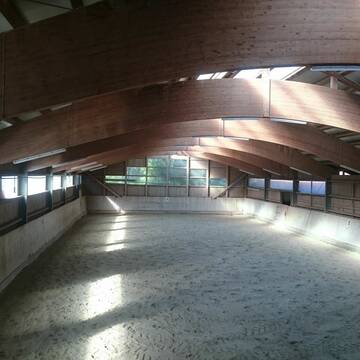
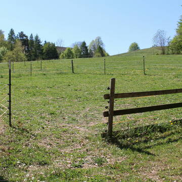
Offen/Laufstall Stuten, Wallache, geschlechtgetren
Stubenberg
Niederbayern Alm
@Niederbayern-Alm
Freizeitstall
Geländestrecke
Vermieten
Hunde willkommen
Krankenbox
Gnadenbrothof
Notfallboxen
29 weitere...
P
Deprecated: Creation of dynamic property Zend_View_Helper_Ads::$adLink is deprecated in /var/www/stall-frei/htdocs/staging.stall-frei.de/library/Psf/View/Helper/Ads.php on line 108

Heu und Heulage verkaufen
Mechtersen
STALL-FREIde Marketing
@STALL-FREI-Marketing
Verkaufen Sie Ihr Heu und Ihre Heulage direkt an Reiter, Pferdeställe und Reitanlagen
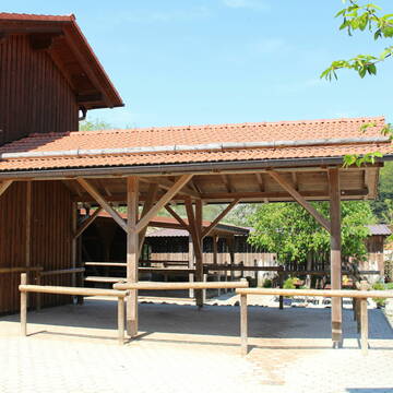
Zucht- und Reitstall Sommer
Simbach am Inn
Sommer Gabriele
@Sommer-Gabriele
FN-Mitglied
Freizeitstall
Vermieten
Verpachten
Führanlage
Krankenbox
Allergikerstall
bedampftes/gewaschenes Heu
33 weitere...
P
Leider kein Vorschaubild
Leider kein Vorschaubild
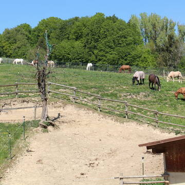
Offenstallplatz frei
Malching
Agnes-Hager
@Agnes-Hager
Freizeitstall
Geländestrecke
Vermieten
Krankenbox
Paddock
Notfallboxen
13 weitere...
B
Reiterhof Gensleiten
Reut
Reiterhof-Gensleiten
@Reiterhof-Gensleiten
FN-Mitglied
Freizeitstall
Vermieten
Krankenbox
Paddock
Notfallboxen
23 weitere...
P+
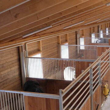
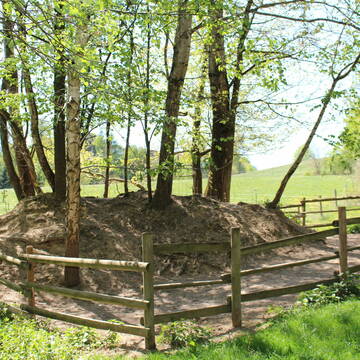
Große Paddockboxen / Offenstallplätze
Triftern
Huber-Englbert
@Huber-Englbert
Freizeitstall
Geländestrecke
Krankenbox
Longierzirkel/Roundpen
Notfallboxen
Außenbox mit Paddock
Offenstall
11 weitere...
P
Leider kein Vorschaubild
Leider kein Vorschaubild
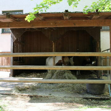
Offenstallplätze für Wallache bis 150cm Stockmaß...
Simbach am Inn
Christiane Troschke
@Troschke
Offenstall
B
Leider kein Vorschaubild
Leider kein Vorschaubild
Offenstall zu verpachten (komb. mit Innenstall)
Bad Griesbach
Reitanlage Birndorfer
@ReitanlageBirndorfer-Hartl
Verpachten
Führanlage
Paddock
Offenstall
Selbstversorgung
6 weitere...
B

Persönlichkeitsentwicklung mit Pferden
Bad Salzuflen
Katja Dors
@Pferdezeiten
Begleite andere auf ihrem Entwicklungsweg und entdecke die transformative Kraft der pferdegestützten Persönlichkeitsentwicklung !
brandneu
R
Leider kein Vorschaubild
Leider kein Vorschaubild
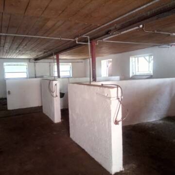
Reitanlage Birndorfer
Bad Griesbach
Reitanlage Birndorfer
@ReitanlageBirndorfer-Hartl
Vermieten
Führanlage
Longierzirkel/Roundpen
Selbstversorgung
Vollpension
Einzelne Boxen oder Stallplätze
Stallgasse oder Stalltrakt
9 weitere...
B
EINSTELLPLÄTZE IN ARTGERECHTER HALTUNG,
Haarbach
Gerhard Hanser
@Christlranch
VFD-Mitglied
Westernreiten
Vermieten
Paddock
Pensions- und Gastboxen
Fohlenaufzucht möglich
Zuchtstutenhaltung möglich
11 weitere...
P
Leider kein Vorschaubild
Leider kein Vorschaubild
Boxen frei
Zeilarn
Reitanlage Schlagmann
@Bettina73
Paddock
Reithalle
Außenboxen
Innenbox
Halbpension
Einzelne Boxen oder Stallplätze
3 weitere...
B
Deprecated: Creation of dynamic property Zend_View::$pageCount is deprecated in /var/www/stall-frei/htdocs/staging.stall-frei.de/library/vendor/shardj/zf1-future/library/Zend/View/Abstract.php on line 308
Deprecated: Creation of dynamic property Zend_View::$itemCountPerPage is deprecated in /var/www/stall-frei/htdocs/staging.stall-frei.de/library/vendor/shardj/zf1-future/library/Zend/View/Abstract.php on line 308
Deprecated: Creation of dynamic property Zend_View::$first is deprecated in /var/www/stall-frei/htdocs/staging.stall-frei.de/library/vendor/shardj/zf1-future/library/Zend/View/Abstract.php on line 308
Deprecated: Creation of dynamic property Zend_View::$current is deprecated in /var/www/stall-frei/htdocs/staging.stall-frei.de/library/vendor/shardj/zf1-future/library/Zend/View/Abstract.php on line 308
Deprecated: Creation of dynamic property Zend_View::$last is deprecated in /var/www/stall-frei/htdocs/staging.stall-frei.de/library/vendor/shardj/zf1-future/library/Zend/View/Abstract.php on line 308
Deprecated: Creation of dynamic property Zend_View::$next is deprecated in /var/www/stall-frei/htdocs/staging.stall-frei.de/library/vendor/shardj/zf1-future/library/Zend/View/Abstract.php on line 308
Deprecated: Creation of dynamic property Zend_View::$pagesInRange is deprecated in /var/www/stall-frei/htdocs/staging.stall-frei.de/library/vendor/shardj/zf1-future/library/Zend/View/Abstract.php on line 308
Deprecated: Creation of dynamic property Zend_View::$firstPageInRange is deprecated in /var/www/stall-frei/htdocs/staging.stall-frei.de/library/vendor/shardj/zf1-future/library/Zend/View/Abstract.php on line 308
Deprecated: Creation of dynamic property Zend_View::$lastPageInRange is deprecated in /var/www/stall-frei/htdocs/staging.stall-frei.de/library/vendor/shardj/zf1-future/library/Zend/View/Abstract.php on line 308
Deprecated: Creation of dynamic property Zend_View::$currentItemCount is deprecated in /var/www/stall-frei/htdocs/staging.stall-frei.de/library/vendor/shardj/zf1-future/library/Zend/View/Abstract.php on line 308
Deprecated: Creation of dynamic property Zend_View::$totalItemCount is deprecated in /var/www/stall-frei/htdocs/staging.stall-frei.de/library/vendor/shardj/zf1-future/library/Zend/View/Abstract.php on line 308
Deprecated: Creation of dynamic property Zend_View::$firstItemNumber is deprecated in /var/www/stall-frei/htdocs/staging.stall-frei.de/library/vendor/shardj/zf1-future/library/Zend/View/Abstract.php on line 308
Deprecated: Creation of dynamic property Zend_View::$lastItemNumber is deprecated in /var/www/stall-frei/htdocs/staging.stall-frei.de/library/vendor/shardj/zf1-future/library/Zend/View/Abstract.php on line 308
Deprecated: Creation of dynamic property Zend_View::$router is deprecated in /var/www/stall-frei/htdocs/staging.stall-frei.de/library/vendor/shardj/zf1-future/library/Zend/View/Abstract.php on line 308
Deprecated: Creation of dynamic property Zend_View::$urlParams is deprecated in /var/www/stall-frei/htdocs/staging.stall-frei.de/library/vendor/shardj/zf1-future/library/Zend/View/Abstract.php on line 308
Deprecated: Creation of dynamic property Zend_View::$showAds is deprecated in /var/www/stall-frei/htdocs/staging.stall-frei.de/library/vendor/shardj/zf1-future/library/Zend/View/Abstract.php on line 308
Deprecated: Creation of dynamic property Zend_View::$objectIds is deprecated in /var/www/stall-frei/htdocs/staging.stall-frei.de/library/vendor/shardj/zf1-future/library/Zend/View/Abstract.php on line 308
Deprecated: Creation of dynamic property Zend_View::$showNavbar is deprecated in /var/www/stall-frei/htdocs/staging.stall-frei.de/library/vendor/shardj/zf1-future/library/Zend/View/Abstract.php on line 308
Deprecated: Creation of dynamic property Zend_View::$showBreadcrumb is deprecated in /var/www/stall-frei/htdocs/staging.stall-frei.de/library/vendor/shardj/zf1-future/library/Zend/View/Abstract.php on line 308
Deprecated: Creation of dynamic property Zend_View::$showFooter is deprecated in /var/www/stall-frei/htdocs/staging.stall-frei.de/library/vendor/shardj/zf1-future/library/Zend/View/Abstract.php on line 308
Deprecated: Creation of dynamic property Zend_View::$showInternalAds is deprecated in /var/www/stall-frei/htdocs/staging.stall-frei.de/library/vendor/shardj/zf1-future/library/Zend/View/Abstract.php on line 308
Deprecated: Creation of dynamic property Zend_View::$blNoContent is deprecated in /var/www/stall-frei/htdocs/staging.stall-frei.de/library/vendor/shardj/zf1-future/library/Zend/View/Abstract.php on line 308
Deprecated: Creation of dynamic property Zend_View::$sMetaDesc is deprecated in /var/www/stall-frei/htdocs/staging.stall-frei.de/library/vendor/shardj/zf1-future/library/Zend/View/Abstract.php on line 308
Deprecated: Creation of dynamic property Zend_View::$useGmaps is deprecated in /var/www/stall-frei/htdocs/staging.stall-frei.de/library/vendor/shardj/zf1-future/library/Zend/View/Abstract.php on line 308
Deprecated: Creation of dynamic property Zend_View::$touches is deprecated in /var/www/stall-frei/htdocs/staging.stall-frei.de/library/vendor/shardj/zf1-future/library/Zend/View/Abstract.php on line 308
Deprecated: Creation of dynamic property Zend_View::$oProject is deprecated in /var/www/stall-frei/htdocs/staging.stall-frei.de/library/vendor/shardj/zf1-future/library/Zend/View/Abstract.php on line 308
Deprecated: Creation of dynamic property Zend_View::$pageHeadline is deprecated in /var/www/stall-frei/htdocs/staging.stall-frei.de/library/vendor/shardj/zf1-future/library/Zend/View/Abstract.php on line 308
Deprecated: Creation of dynamic property Zend_View::$disableLocationField is deprecated in /var/www/stall-frei/htdocs/staging.stall-frei.de/library/vendor/shardj/zf1-future/library/Zend/View/Abstract.php on line 308
Deprecated: Creation of dynamic property Zend_View::$isSearch is deprecated in /var/www/stall-frei/htdocs/staging.stall-frei.de/library/vendor/shardj/zf1-future/library/Zend/View/Abstract.php on line 308
Deprecated: Creation of dynamic property Zend_View::$pageTitle is deprecated in /var/www/stall-frei/htdocs/staging.stall-frei.de/library/vendor/shardj/zf1-future/library/Zend/View/Abstract.php on line 308
Deprecated: Creation of dynamic property Psf_Form_Element_Text::$class is deprecated in /var/www/stall-frei/htdocs/staging.stall-frei.de/library/vendor/shardj/zf1-future/library/Zend/Form/Element.php on line 874
Deprecated: Creation of dynamic property Psf_Form_Element_Text::$size is deprecated in /var/www/stall-frei/htdocs/staging.stall-frei.de/library/vendor/shardj/zf1-future/library/Zend/Form/Element.php on line 874
Deprecated: Creation of dynamic property Psf_Form_Element_Text::$placeholder is deprecated in /var/www/stall-frei/htdocs/staging.stall-frei.de/library/vendor/shardj/zf1-future/library/Zend/Form/Element.php on line 874
Deprecated: Creation of dynamic property Psf_Form_Element_Hidden::$class is deprecated in /var/www/stall-frei/htdocs/staging.stall-frei.de/library/vendor/shardj/zf1-future/library/Zend/Form/Element.php on line 874
Deprecated: Creation of dynamic property Psf_Form_Element_Hidden::$class is deprecated in /var/www/stall-frei/htdocs/staging.stall-frei.de/library/vendor/shardj/zf1-future/library/Zend/Form/Element.php on line 874
Deprecated: Creation of dynamic property Psf_Form_Element_Hidden::$class is deprecated in /var/www/stall-frei/htdocs/staging.stall-frei.de/library/vendor/shardj/zf1-future/library/Zend/Form/Element.php on line 874
Deprecated: Creation of dynamic property Psf_Form_Element_Hidden::$class is deprecated in /var/www/stall-frei/htdocs/staging.stall-frei.de/library/vendor/shardj/zf1-future/library/Zend/Form/Element.php on line 874
Deprecated: Creation of dynamic property Psf_Form_Element_Select::$class is deprecated in /var/www/stall-frei/htdocs/staging.stall-frei.de/library/vendor/shardj/zf1-future/library/Zend/Form/Element.php on line 874
Deprecated: Creation of dynamic property Psf_Form_Element_Select::$class is deprecated in /var/www/stall-frei/htdocs/staging.stall-frei.de/library/vendor/shardj/zf1-future/library/Zend/Form/Element.php on line 874
Deprecated: Creation of dynamic property Psf_Form_Element_Select::$class is deprecated in /var/www/stall-frei/htdocs/staging.stall-frei.de/library/vendor/shardj/zf1-future/library/Zend/Form/Element.php on line 874
Deprecated: Creation of dynamic property Psf_Form_Element_Select::$class is deprecated in /var/www/stall-frei/htdocs/staging.stall-frei.de/library/vendor/shardj/zf1-future/library/Zend/Form/Element.php on line 874
Deprecated: Creation of dynamic property Psf_Form_Element_Text::$class is deprecated in /var/www/stall-frei/htdocs/staging.stall-frei.de/library/vendor/shardj/zf1-future/library/Zend/Form/Element.php on line 874
Deprecated: Creation of dynamic property Psf_Form_Element_Checkbox::$label is deprecated in /var/www/stall-frei/htdocs/staging.stall-frei.de/library/vendor/shardj/zf1-future/library/Zend/Form/Element.php on line 874
Deprecated: Creation of dynamic property Zend_View::$sort is deprecated in /var/www/stall-frei/htdocs/staging.stall-frei.de/library/vendor/shardj/zf1-future/library/Zend/View/Abstract.php on line 308
Deprecated: Creation of dynamic property Zend_View::$searchLocation is deprecated in /var/www/stall-frei/htdocs/staging.stall-frei.de/library/vendor/shardj/zf1-future/library/Zend/View/Abstract.php on line 308
Deprecated: Creation of dynamic property Zend_View::$locationHint is deprecated in /var/www/stall-frei/htdocs/staging.stall-frei.de/library/vendor/shardj/zf1-future/library/Zend/View/Abstract.php on line 308
Psf_GeoCoder_Abstract::getLocation: Ering Get Location CachedOrLive
Psf_GeoCoder_Abstract::getCachedOrLive: Ering
Psf_GeoCoder_OpenCageData::makeApiRequest: response:
Array
(
[documentation] => https://opencagedata.com/api
[licenses] => Array
(
[0] => Array
(
[name] => see attribution guide
[url] => https://opencagedata.com/credits
)
)
[results] => Array
(
[0] => Array
(
[bounds] => Array
(
[northeast] => Array
(
[lat] => 48.3527036
[lng] => 13.176942
)
[southwest] => Array
(
[lat] => 48.2772994
[lng] => 13.0717405
)
)
[components] => Array
(
[ISO_3166-1_alpha-2] => DE
[ISO_3166-1_alpha-3] => DEU
[ISO_3166-2] => Array
(
[0] => DE-BY
)
[_category] => place
[_normalized_city] => Ering
[_type] => village
[continent] => Europe
[country] => Deutschland
[country_code] => de
[county] => Landkreis Rottal-Inn
[municipality] => Ering (VGem)
[political_union] => European Union
[postcode] => 94140
[state] => Bayern
[state_code] => BY
[village] => Ering
)
[confidence] => 7
[formatted] => 94140 Ering, Deutschland
[geometry] => Array
(
[lat] => 48.3
[lng] => 13.15
)
)
[1] => Array
(
[bounds] => Array
(
[northeast] => Array
(
[lat] => 48.3677816
[lng] => 13.176942
)
[southwest] => Array
(
[lat] => 48.2772635
[lng] => 13.032155
)
)
[components] => Array
(
[ISO_3166-1_alpha-2] => DE
[ISO_3166-1_alpha-3] => DEU
[ISO_3166-2] => Array
(
[0] => DE-BY
)
[_category] => place
[_normalized_city] => Ering (VGem)
[_type] => municipality
[continent] => Europe
[country] => Deutschland
[country_code] => de
[county] => Landkreis Rottal-Inn
[municipality] => Ering (VGem)
[political_union] => European Union
[state] => Bayern
[state_code] => BY
)
[confidence] => 6
[formatted] => Ering (VGem), Bayern, Deutschland
[geometry] => Array
(
[lat] => 48.3226385
[lng] => 13.0958917
)
)
[2] => Array
(
[components] => Array
(
[ISO_3166-1_alpha-2] => FR
[ISO_3166-1_alpha-3] => FRA
[ISO_3166-2] => Array
(
[0] => FR-HDF
[1] => FR-59
)
[_category] => road
[_normalized_city] => Hérin
[_type] => road
[city] => Hérin
[continent] => Europe
[country] => France
[country_code] => fr
[county] => Nord
[local_authority] => Communauté d'agglomération de la Porte du Hainaut
[political_union] => European Union
[postcode] => 59195
[road] => Chemin de Bellaing
[state] => Hauts-de-France
[state_code] => HDF
)
[confidence] => 3
[formatted] => Chemin de Bellaing, 59195 Hérin, France
[geometry] => Array
(
[lat] => 50.376174
[lng] => 3.430541
)
)
[3] => Array
(
[components] => Array
(
[ISO_3166-1_alpha-2] => FR
[ISO_3166-1_alpha-3] => FRA
[ISO_3166-2] => Array
(
[0] => FR-HDF
[1] => FR-59
)
[_category] => road
[_normalized_city] => Hérin
[_type] => road
[city] => Hérin
[continent] => Europe
[country] => France
[country_code] => fr
[county] => Nord
[local_authority] => Communauté d'agglomération de la Porte du Hainaut
[political_union] => European Union
[postcode] => 59195
[road] => Rue des Blancs Rieux
[state] => Hauts-de-France
[state_code] => HDF
)
[confidence] => 2
[formatted] => Rue des Blancs Rieux, 59195 Hérin, France
[geometry] => Array
(
[lat] => 50.350025
[lng] => 3.457702
)
)
[4] => Array
(
[components] => Array
(
[ISO_3166-1_alpha-2] => FR
[ISO_3166-1_alpha-3] => FRA
[ISO_3166-2] => Array
(
[0] => FR-HDF
[1] => FR-59
)
[_category] => road
[_normalized_city] => Raismes
[_type] => road
[city] => Raismes
[continent] => Europe
[country] => France
[country_code] => fr
[county] => Nord
[local_authority] => Communauté d'agglomération de la Porte du Hainaut
[political_union] => European Union
[postcode] => 59590
[road] => Chemin d’Herin
[state] => Hauts-de-France
[state_code] => HDF
)
[confidence] => 2
[formatted] => Chemin d’Herin, 59590 Raismes, France
[geometry] => Array
(
[lat] => 50.378803
[lng] => 3.433183
)
)
[5] => Array
(
[components] => Array
(
[ISO_3166-1_alpha-2] => FR
[ISO_3166-1_alpha-3] => FRA
[ISO_3166-2] => Array
(
[0] => FR-HDF
[1] => FR-59
)
[_category] => road
[_normalized_city] => Rouvignies
[_type] => road
[city] => Rouvignies
[continent] => Europe
[country] => France
[country_code] => fr
[county] => Nord
[local_authority] => Communauté d’agglomération Valenciennes Métropole
[political_union] => European Union
[postcode] => 59220
[road] => Route d'Hérin
[state] => Hauts-de-France
[state_code] => HDF
)
[confidence] => 2
[formatted] => Route d'Hérin, 59220 Rouvignies, France
[geometry] => Array
(
[lat] => 50.34498
[lng] => 3.453301
)
)
[6] => Array
(
[components] => Array
(
[ISO_3166-1_alpha-2] => FR
[ISO_3166-1_alpha-3] => FRA
[ISO_3166-2] => Array
(
[0] => FR-HDF
[1] => FR-59
)
[_category] => road
[_normalized_city] => Wallers
[_type] => road
[city] => Wallers
[continent] => Europe
[country] => France
[country_code] => fr
[county] => Nord
[local_authority] => Communauté d'agglomération de la Porte du Hainaut
[political_union] => European Union
[postcode] => 59135
[road] => Chemin d’Herin
[state] => Hauts-de-France
[state_code] => HDF
)
[confidence] => 2
[formatted] => Chemin d’Herin, 59135 Wallers, France
[geometry] => Array
(
[lat] => 50.379031
[lng] => 3.4322
)
)
[7] => Array
(
[components] => Array
(
[ISO_3166-1_alpha-2] => FR
[ISO_3166-1_alpha-3] => FRA
[ISO_3166-2] => Array
(
[0] => FR-PDL
[1] => FR-49
)
[_category] => road
[_normalized_city] => Chaudefonds-sur-Layon
[_type] => road
[city] => Chaudefonds-sur-Layon
[continent] => Europe
[country] => France
[country_code] => fr
[county] => Maine-et-Loire
[local_authority] => Communauté de communes Loire Layon Aubance
[political_union] => European Union
[postcode] => 49290
[road] => Chemin des Herrines
[state] => Pays de la Loire
[state_code] => PDL
)
[confidence] => 2
[formatted] => Chemin des Herrines, 49290 Chaudefonds-sur-Layon, France
[geometry] => Array
(
[lat] => 47.322933
[lng] => -0.700898
)
)
[8] => Array
(
[components] => Array
(
[ISO_3166-1_alpha-2] => FR
[ISO_3166-1_alpha-3] => FRA
[ISO_3166-2] => Array
(
[0] => FR-HDF
[1] => FR-59
)
[_category] => road
[_normalized_city] => Prouvy
[_type] => road
[city] => Prouvy
[continent] => Europe
[country] => France
[country_code] => fr
[county] => Nord
[local_authority] => Communauté d’agglomération Valenciennes Métropole
[political_union] => European Union
[postcode] => 59121
[road] => Route d’Herin
[state] => Hauts-de-France
[state_code] => HDF
)
[confidence] => 2
[formatted] => Route d’Herin, 59121 Prouvy, France
[geometry] => Array
(
[lat] => 50.344056
[lng] => 3.453645
)
)
[9] => Array
(
[components] => Array
(
[ISO_3166-1_alpha-2] => FR
[ISO_3166-1_alpha-3] => FRA
[ISO_3166-2] => Array
(
[0] => FR-HDF
[1] => FR-59
)
[_category] => road
[_normalized_city] => Hérin
[_type] => road
[city] => Hérin
[continent] => Europe
[country] => France
[country_code] => fr
[county] => Nord
[local_authority] => Communauté d'agglomération de la Porte du Hainaut
[political_union] => European Union
[postcode] => 59195
[road] => Rue de Nieuport
[state] => Hauts-de-France
[state_code] => HDF
)
[confidence] => 2
[formatted] => Rue de Nieuport, 59195 Hérin, France
[geometry] => Array
(
[lat] => 50.348273
[lng] => 3.459428
)
)
)
[status] => Array
(
[code] => 200
[message] => OK
)
[stay_informed] => Array
(
[blog] => https://blog.opencagedata.com
[mastodon] => https://en.osm.town/@opencage
)
[thanks] => For using an OpenCage API
[timestamp] => Array
(
[created_http] => Wed, 04 Feb 2026 05:27:13 GMT
[created_unix] => 1770182833
)
[total_results] => 10
)
Psf_GeoCoder_Abstract::convertLocationResult
{"documentation":"https:\/\/opencagedata.com\/api","licenses":[{"name":"see attribution guide","url":"https:\/\/opencagedata.com\/credits"}],"results":[{"bounds":{"northeast":{"lat":48.3527036,"lng":13.176942},"southwest":{"lat":48.2772994,"lng":13.0717405}},"components":{"ISO_3166-1_alpha-2":"DE","ISO_3166-1_alpha-3":"DEU","ISO_3166-2":["DE-BY"],"_category":"place","_normalized_city":"Ering","_type":"village","continent":"Europe","country":"Deutschland","country_code":"de","county":"Landkreis Rottal-Inn","municipality":"Ering (VGem)","political_union":"European Union","postcode":"94140","state":"Bayern","state_code":"BY","village":"Ering"},"confidence":7,"formatted":"94140 Ering, Deutschland","geometry":{"lat":48.3,"lng":13.15}},{"bounds":{"northeast":{"lat":48.3677816,"lng":13.176942},"southwest":{"lat":48.2772635,"lng":13.032155}},"components":{"ISO_3166-1_alpha-2":"DE","ISO_3166-1_alpha-3":"DEU","ISO_3166-2":["DE-BY"],"_category":"place","_normalized_city":"Ering (VGem)","_type":"municipality","continent":"Europe","country":"Deutschland","country_code":"de","county":"Landkreis Rottal-Inn","municipality":"Ering (VGem)","political_union":"European Union","state":"Bayern","state_code":"BY"},"confidence":6,"formatted":"Ering (VGem), Bayern, Deutschland","geometry":{"lat":48.3226385,"lng":13.0958917}},{"components":{"ISO_3166-1_alpha-2":"FR","ISO_3166-1_alpha-3":"FRA","ISO_3166-2":["FR-HDF","FR-59"],"_category":"road","_normalized_city":"H\u00e9rin","_type":"road","city":"H\u00e9rin","continent":"Europe","country":"France","country_code":"fr","county":"Nord","local_authority":"Communaut\u00e9 d'agglom\u00e9ration de la Porte du Hainaut","political_union":"European Union","postcode":"59195","road":"Chemin de Bellaing","state":"Hauts-de-France","state_code":"HDF"},"confidence":3,"formatted":"Chemin de Bellaing, 59195 H\u00e9rin, France","geometry":{"lat":50.376174,"lng":3.430541}},{"components":{"ISO_3166-1_alpha-2":"FR","ISO_3166-1_alpha-3":"FRA","ISO_3166-2":["FR-HDF","FR-59"],"_category":"road","_normalized_city":"H\u00e9rin","_type":"road","city":"H\u00e9rin","continent":"Europe","country":"France","country_code":"fr","county":"Nord","local_authority":"Communaut\u00e9 d'agglom\u00e9ration de la Porte du Hainaut","political_union":"European Union","postcode":"59195","road":"Rue des Blancs Rieux","state":"Hauts-de-France","state_code":"HDF"},"confidence":2,"formatted":"Rue des Blancs Rieux, 59195 H\u00e9rin, France","geometry":{"lat":50.350025,"lng":3.457702}},{"components":{"ISO_3166-1_alpha-2":"FR","ISO_3166-1_alpha-3":"FRA","ISO_3166-2":["FR-HDF","FR-59"],"_category":"road","_normalized_city":"Raismes","_type":"road","city":"Raismes","continent":"Europe","country":"France","country_code":"fr","county":"Nord","local_authority":"Communaut\u00e9 d'agglom\u00e9ration de la Porte du Hainaut","political_union":"European Union","postcode":"59590","road":"Chemin d\u2019Herin","state":"Hauts-de-France","state_code":"HDF"},"confidence":2,"formatted":"Chemin d\u2019Herin, 59590 Raismes, France","geometry":{"lat":50.378803,"lng":3.433183}},{"components":{"ISO_3166-1_alpha-2":"FR","ISO_3166-1_alpha-3":"FRA","ISO_3166-2":["FR-HDF","FR-59"],"_category":"road","_normalized_city":"Rouvignies","_type":"road","city":"Rouvignies","continent":"Europe","country":"France","country_code":"fr","county":"Nord","local_authority":"Communaut\u00e9 d\u2019agglom\u00e9ration Valenciennes M\u00e9tropole","political_union":"European Union","postcode":"59220","road":"Route d'H\u00e9rin","state":"Hauts-de-France","state_code":"HDF"},"confidence":2,"formatted":"Route d'H\u00e9rin, 59220 Rouvignies, France","geometry":{"lat":50.34498,"lng":3.453301}},{"components":{"ISO_3166-1_alpha-2":"FR","ISO_3166-1_alpha-3":"FRA","ISO_3166-2":["FR-HDF","FR-59"],"_category":"road","_normalized_city":"Wallers","_type":"road","city":"Wallers","continent":"Europe","country":"France","country_code":"fr","county":"Nord","local_authority":"Communaut\u00e9 d'agglom\u00e9ration de la Porte du Hainaut","political_union":"European Union","postcode":"59135","road":"Chemin d\u2019Herin","state":"Hauts-de-France","state_code":"HDF"},"confidence":2,"formatted":"Chemin d\u2019Herin, 59135 Wallers, France","geometry":{"lat":50.379031,"lng":3.4322}},{"components":{"ISO_3166-1_alpha-2":"FR","ISO_3166-1_alpha-3":"FRA","ISO_3166-2":["FR-PDL","FR-49"],"_category":"road","_normalized_city":"Chaudefonds-sur-Layon","_type":"road","city":"Chaudefonds-sur-Layon","continent":"Europe","country":"France","country_code":"fr","county":"Maine-et-Loire","local_authority":"Communaut\u00e9 de communes Loire Layon Aubance","political_union":"European Union","postcode":"49290","road":"Chemin des Herrines","state":"Pays de la Loire","state_code":"PDL"},"confidence":2,"formatted":"Chemin des Herrines, 49290 Chaudefonds-sur-Layon, France","geometry":{"lat":47.322933,"lng":-0.700898}},{"components":{"ISO_3166-1_alpha-2":"FR","ISO_3166-1_alpha-3":"FRA","ISO_3166-2":["FR-HDF","FR-59"],"_category":"road","_normalized_city":"Prouvy","_type":"road","city":"Prouvy","continent":"Europe","country":"France","country_code":"fr","county":"Nord","local_authority":"Communaut\u00e9 d\u2019agglom\u00e9ration Valenciennes M\u00e9tropole","political_union":"European Union","postcode":"59121","road":"Route d\u2019Herin","state":"Hauts-de-France","state_code":"HDF"},"confidence":2,"formatted":"Route d\u2019Herin, 59121 Prouvy, France","geometry":{"lat":50.344056,"lng":3.453645}},{"components":{"ISO_3166-1_alpha-2":"FR","ISO_3166-1_alpha-3":"FRA","ISO_3166-2":["FR-HDF","FR-59"],"_category":"road","_normalized_city":"H\u00e9rin","_type":"road","city":"H\u00e9rin","continent":"Europe","country":"France","country_code":"fr","county":"Nord","local_authority":"Communaut\u00e9 d'agglom\u00e9ration de la Porte du Hainaut","political_union":"European Union","postcode":"59195","road":"Rue de Nieuport","state":"Hauts-de-France","state_code":"HDF"},"confidence":2,"formatted":"Rue de Nieuport, 59195 H\u00e9rin, France","geometry":{"lat":50.348273,"lng":3.459428}}],"status":{"code":200,"message":"OK"},"stay_informed":{"blog":"https:\/\/blog.opencagedata.com","mastodon":"https:\/\/en.osm.town\/@opencage"},"thanks":"For using an OpenCage API","timestamp":{"created_http":"Wed, 04 Feb 2026 05:27:13 GMT","created_unix":1770182833},"total_results":10}Array
(
[0] => stdClass Object
(
[bounds] => stdClass Object
(
[northeast] => stdClass Object
(
[lat] => 48.3527036
[lng] => 13.176942
)
[southwest] => stdClass Object
(
[lat] => 48.2772994
[lng] => 13.0717405
)
)
[components] => stdClass Object
(
[ISO_3166-1_alpha-2] => DE
[ISO_3166-1_alpha-3] => DEU
[ISO_3166-2] => Array
(
[0] => DE-BY
)
[_category] => place
[_normalized_city] => Ering
[_type] => village
[continent] => Europe
[country] => Deutschland
[country_code] => de
[county] => Landkreis Rottal-Inn
[municipality] => Ering (VGem)
[political_union] => European Union
[postcode] => 94140
[state] => Bayern
[state_code] => BY
[village] => Ering
)
[confidence] => 7
[formatted] => 94140 Ering, Deutschland
[geometry] => stdClass Object
(
[lat] => 48.3
[lng] => 13.15
)
)
[1] => stdClass Object
(
[bounds] => stdClass Object
(
[northeast] => stdClass Object
(
[lat] => 48.3677816
[lng] => 13.176942
)
[southwest] => stdClass Object
(
[lat] => 48.2772635
[lng] => 13.032155
)
)
[components] => stdClass Object
(
[ISO_3166-1_alpha-2] => DE
[ISO_3166-1_alpha-3] => DEU
[ISO_3166-2] => Array
(
[0] => DE-BY
)
[_category] => place
[_normalized_city] => Ering (VGem)
[_type] => municipality
[continent] => Europe
[country] => Deutschland
[country_code] => de
[county] => Landkreis Rottal-Inn
[municipality] => Ering (VGem)
[political_union] => European Union
[state] => Bayern
[state_code] => BY
)
[confidence] => 6
[formatted] => Ering (VGem), Bayern, Deutschland
[geometry] => stdClass Object
(
[lat] => 48.3226385
[lng] => 13.0958917
)
)
[2] => stdClass Object
(
[components] => stdClass Object
(
[ISO_3166-1_alpha-2] => FR
[ISO_3166-1_alpha-3] => FRA
[ISO_3166-2] => Array
(
[0] => FR-HDF
[1] => FR-59
)
[_category] => road
[_normalized_city] => Hérin
[_type] => road
[city] => Hérin
[continent] => Europe
[country] => France
[country_code] => fr
[county] => Nord
[local_authority] => Communauté d'agglomération de la Porte du Hainaut
[political_union] => European Union
[postcode] => 59195
[road] => Chemin de Bellaing
[state] => Hauts-de-France
[state_code] => HDF
)
[confidence] => 3
[formatted] => Chemin de Bellaing, 59195 Hérin, France
[geometry] => stdClass Object
(
[lat] => 50.376174
[lng] => 3.430541
)
)
[3] => stdClass Object
(
[components] => stdClass Object
(
[ISO_3166-1_alpha-2] => FR
[ISO_3166-1_alpha-3] => FRA
[ISO_3166-2] => Array
(
[0] => FR-HDF
[1] => FR-59
)
[_category] => road
[_normalized_city] => Hérin
[_type] => road
[city] => Hérin
[continent] => Europe
[country] => France
[country_code] => fr
[county] => Nord
[local_authority] => Communauté d'agglomération de la Porte du Hainaut
[political_union] => European Union
[postcode] => 59195
[road] => Rue des Blancs Rieux
[state] => Hauts-de-France
[state_code] => HDF
)
[confidence] => 2
[formatted] => Rue des Blancs Rieux, 59195 Hérin, France
[geometry] => stdClass Object
(
[lat] => 50.350025
[lng] => 3.457702
)
)
[4] => stdClass Object
(
[components] => stdClass Object
(
[ISO_3166-1_alpha-2] => FR
[ISO_3166-1_alpha-3] => FRA
[ISO_3166-2] => Array
(
[0] => FR-HDF
[1] => FR-59
)
[_category] => road
[_normalized_city] => Raismes
[_type] => road
[city] => Raismes
[continent] => Europe
[country] => France
[country_code] => fr
[county] => Nord
[local_authority] => Communauté d'agglomération de la Porte du Hainaut
[political_union] => European Union
[postcode] => 59590
[road] => Chemin d’Herin
[state] => Hauts-de-France
[state_code] => HDF
)
[confidence] => 2
[formatted] => Chemin d’Herin, 59590 Raismes, France
[geometry] => stdClass Object
(
[lat] => 50.378803
[lng] => 3.433183
)
)
[5] => stdClass Object
(
[components] => stdClass Object
(
[ISO_3166-1_alpha-2] => FR
[ISO_3166-1_alpha-3] => FRA
[ISO_3166-2] => Array
(
[0] => FR-HDF
[1] => FR-59
)
[_category] => road
[_normalized_city] => Rouvignies
[_type] => road
[city] => Rouvignies
[continent] => Europe
[country] => France
[country_code] => fr
[county] => Nord
[local_authority] => Communauté d’agglomération Valenciennes Métropole
[political_union] => European Union
[postcode] => 59220
[road] => Route d'Hérin
[state] => Hauts-de-France
[state_code] => HDF
)
[confidence] => 2
[formatted] => Route d'Hérin, 59220 Rouvignies, France
[geometry] => stdClass Object
(
[lat] => 50.34498
[lng] => 3.453301
)
)
[6] => stdClass Object
(
[components] => stdClass Object
(
[ISO_3166-1_alpha-2] => FR
[ISO_3166-1_alpha-3] => FRA
[ISO_3166-2] => Array
(
[0] => FR-HDF
[1] => FR-59
)
[_category] => road
[_normalized_city] => Wallers
[_type] => road
[city] => Wallers
[continent] => Europe
[country] => France
[country_code] => fr
[county] => Nord
[local_authority] => Communauté d'agglomération de la Porte du Hainaut
[political_union] => European Union
[postcode] => 59135
[road] => Chemin d’Herin
[state] => Hauts-de-France
[state_code] => HDF
)
[confidence] => 2
[formatted] => Chemin d’Herin, 59135 Wallers, France
[geometry] => stdClass Object
(
[lat] => 50.379031
[lng] => 3.4322
)
)
[7] => stdClass Object
(
[components] => stdClass Object
(
[ISO_3166-1_alpha-2] => FR
[ISO_3166-1_alpha-3] => FRA
[ISO_3166-2] => Array
(
[0] => FR-PDL
[1] => FR-49
)
[_category] => road
[_normalized_city] => Chaudefonds-sur-Layon
[_type] => road
[city] => Chaudefonds-sur-Layon
[continent] => Europe
[country] => France
[country_code] => fr
[county] => Maine-et-Loire
[local_authority] => Communauté de communes Loire Layon Aubance
[political_union] => European Union
[postcode] => 49290
[road] => Chemin des Herrines
[state] => Pays de la Loire
[state_code] => PDL
)
[confidence] => 2
[formatted] => Chemin des Herrines, 49290 Chaudefonds-sur-Layon, France
[geometry] => stdClass Object
(
[lat] => 47.322933
[lng] => -0.700898
)
)
[8] => stdClass Object
(
[components] => stdClass Object
(
[ISO_3166-1_alpha-2] => FR
[ISO_3166-1_alpha-3] => FRA
[ISO_3166-2] => Array
(
[0] => FR-HDF
[1] => FR-59
)
[_category] => road
[_normalized_city] => Prouvy
[_type] => road
[city] => Prouvy
[continent] => Europe
[country] => France
[country_code] => fr
[county] => Nord
[local_authority] => Communauté d’agglomération Valenciennes Métropole
[political_union] => European Union
[postcode] => 59121
[road] => Route d’Herin
[state] => Hauts-de-France
[state_code] => HDF
)
[confidence] => 2
[formatted] => Route d’Herin, 59121 Prouvy, France
[geometry] => stdClass Object
(
[lat] => 50.344056
[lng] => 3.453645
)
)
[9] => stdClass Object
(
[components] => stdClass Object
(
[ISO_3166-1_alpha-2] => FR
[ISO_3166-1_alpha-3] => FRA
[ISO_3166-2] => Array
(
[0] => FR-HDF
[1] => FR-59
)
[_category] => road
[_normalized_city] => Hérin
[_type] => road
[city] => Hérin
[continent] => Europe
[country] => France
[country_code] => fr
[county] => Nord
[local_authority] => Communauté d'agglomération de la Porte du Hainaut
[political_union] => European Union
[postcode] => 59195
[road] => Rue de Nieuport
[state] => Hauts-de-France
[state_code] => HDF
)
[confidence] => 2
[formatted] => Rue de Nieuport, 59195 Hérin, France
[geometry] => stdClass Object
(
[lat] => 50.348273
[lng] => 3.459428
)
)
)
Psf_GeoCoder_OpenCageData::getKeyMap: 0
stdClass Object
(
    [bounds] => stdClass Object
        (
            [northeast] => stdClass Object
                (
                    [lat] => 48.3527036
                    [lng] => 13.176942
                )

            [southwest] => stdClass Object
                (
                    [lat] => 48.2772994
                    [lng] => 13.0717405
                )

        )

    [components] => stdClass Object
        (
            [ISO_3166-1_alpha-2] => DE
            [ISO_3166-1_alpha-3] => DEU
            [ISO_3166-2] => Array
                (
                    [0] => DE-BY
                )

            [_category] => place
            [_normalized_city] => Ering
            [_type] => village
            [continent] => Europe
            [country] => Deutschland
            [country_code] => de
            [county] => Landkreis Rottal-Inn
            [municipality] => Ering (VGem)
            [political_union] => European Union
            [postcode] => 94140
            [state] => Bayern
            [state_code] => BY
            [village] => Ering
        )

    [confidence] => 7
    [formatted] => 94140 Ering, Deutschland
    [geometry] => stdClass Object
        (
            [lat] => 48.3
            [lng] => 13.15
        )

)
Psf_GeoCoder_OpenCageData::getCounty: Rottal-Inn
Psf_GeoCoder_OpenCageData::addMissingData REFETCH!
Array
(
    [address] => 94140 Ering, Deutschland
    [type] => village
    [street] =>
    [city] => Ering
    [county] => Rottal-Inn
    [state] => Bayern
    [zip] => 94140
    [country] => Deutschland
    [suburb] =>
    [countrycode] => de
    [latitude] => 48.3
    [longitude] => 13.15
    [accuracy] => 1
    [confidence] => 7
    [bounds] => stdClass Object
        (
            [northeast] => stdClass Object
                (
                    [lat] => 48.3527036
                    [lng] => 13.176942
                )

            [southwest] => stdClass Object
                (
                    [lat] => 48.2772994
                    [lng] => 13.0717405
                )

        )

)
reformat!
Array
(
    [address] => 94140 Ering, Deutschland
    [type] => village
    [street] =>
    [city] => Ering
    [county] => Rottal-Inn
    [state] => Bayern
    [zip] => 94140
    [country] => Deutschland
    [suburb] =>
    [countrycode] => de
    [latitude] => 48.3
    [longitude] => 13.15
    [accuracy] => 1
    [confidence] => 7
    [bounds] => stdClass Object
        (
            [northeast] => stdClass Object
                (
                    [lat] => 48.3527036
                    [lng] => 13.176942
                )

            [southwest] => stdClass Object
                (
                    [lat] => 48.2772994
                    [lng] => 13.0717405
                )

        )

    [place] => 94140 Ering, Bayern
    [hash] => c87e444f4197001e43f302be2c5f2c85
)
Psf_GeoCoder_OpenCageData::getKeyMap: 1
stdClass Object
(
    [bounds] => stdClass Object
        (
            [northeast] => stdClass Object
                (
                    [lat] => 48.3677816
                    [lng] => 13.176942
                )

            [southwest] => stdClass Object
                (
                    [lat] => 48.2772635
                    [lng] => 13.032155
                )

        )

    [components] => stdClass Object
        (
            [ISO_3166-1_alpha-2] => DE
            [ISO_3166-1_alpha-3] => DEU
            [ISO_3166-2] => Array
                (
                    [0] => DE-BY
                )

            [_category] => place
            [_normalized_city] => Ering (VGem)
            [_type] => municipality
            [continent] => Europe
            [country] => Deutschland
            [country_code] => de
            [county] => Landkreis Rottal-Inn
            [municipality] => Ering (VGem)
            [political_union] => European Union
            [state] => Bayern
            [state_code] => BY
        )

    [confidence] => 6
    [formatted] => Ering (VGem), Bayern, Deutschland
    [geometry] => stdClass Object
        (
            [lat] => 48.3226385
            [lng] => 13.0958917
        )

)
Psf_GeoCoder_OpenCageData::getCounty: Rottal-Inn
Psf_GeoCoder_OpenCageData::addMissingData REFETCH!
Array
(
    [address] => Ering (VGem), Bayern, Deutschland
    [type] => municipality
    [street] =>
    [city] =>
    [county] => Rottal-Inn
    [state] => Bayern
    [zip] =>
    [country] => Deutschland
    [suburb] =>
    [countrycode] => de
    [latitude] => 48.3226385
    [longitude] => 13.0958917
    [accuracy] => 1
    [confidence] => 6
    [bounds] => stdClass Object
        (
            [northeast] => stdClass Object
                (
                    [lat] => 48.3677816
                    [lng] => 13.176942
                )

            [southwest] => stdClass Object
                (
                    [lat] => 48.2772635
                    [lng] => 13.032155
                )

        )

)
reformat!
Array
(
    [address] => Ering (VGem), Bayern, Deutschland
    [type] => municipality
    [street] =>
    [city] =>
    [county] => Rottal-Inn
    [state] => Bayern
    [zip] =>
    [country] => Deutschland
    [suburb] =>
    [countrycode] => de
    [latitude] => 48.3226385
    [longitude] => 13.0958917
    [accuracy] => 1
    [confidence] => 6
    [bounds] => stdClass Object
        (
            [northeast] => stdClass Object
                (
                    [lat] => 48.3677816
                    [lng] => 13.176942
                )

            [southwest] => stdClass Object
                (
                    [lat] => 48.2772635
                    [lng] => 13.032155
                )

        )

    [place] => , Bayern
    [hash] => 665b3ba80c07f525effa36eea15d58d9
)
Psf_GeoCoder_OpenCageData::getKeyMap: 2
stdClass Object
(
    [components] => stdClass Object
        (
            [ISO_3166-1_alpha-2] => FR
            [ISO_3166-1_alpha-3] => FRA
            [ISO_3166-2] => Array
                (
                    [0] => FR-HDF
                    [1] => FR-59
                )

            [_category] => road
            [_normalized_city] => Hérin
            [_type] => road
            [city] => Hérin
            [continent] => Europe
            [country] => France
            [country_code] => fr
            [county] => Nord
            [local_authority] => Communauté d'agglomération de la Porte du Hainaut
            [political_union] => European Union
            [postcode] => 59195
            [road] => Chemin de Bellaing
            [state] => Hauts-de-France
            [state_code] => HDF
        )

    [confidence] => 3
    [formatted] => Chemin de Bellaing, 59195 Hérin, France
    [geometry] => stdClass Object
        (
            [lat] => 50.376174
            [lng] => 3.430541
        )

)
Psf_GeoCoder_OpenCageData::getCounty: Nord
Psf_GeoCoder_OpenCageData::addMissingData REFETCH!
Array
(
    [address] => Chemin de Bellaing, 59195 Hérin, France
    [type] => road
    [street] => Chemin de Bellaing
    [city] => Hérin
    [county] => Nord
    [state] => Hauts-de-France
    [zip] => 59195
    [country] => France
    [suburb] =>
    [countrycode] => fr
    [latitude] => 50.376174
    [longitude] => 3.430541
    [accuracy] => 1
    [confidence] => 3
    [bounds] =>
)
reformat!
Array
(
    [address] => Chemin de Bellaing, 59195 Hérin, France
    [type] => road
    [street] => Chemin de Bellaing
    [city] => Hérin
    [county] => Nord
    [state] => Hauts-de-France
    [zip] => 59195
    [country] => France
    [suburb] =>
    [countrycode] => fr
    [latitude] => 50.376174
    [longitude] => 3.430541
    [accuracy] => 1
    [confidence] => 3
    [bounds] =>
    [place] => Chemin de Bellaing, 59195 Hérin, Hauts-de-France
    [hash] => e546828b3f997d2bc4e1f31fab2cf6e3
)
Psf_GeoCoder_OpenCageData::getKeyMap: 3
stdClass Object
(
    [components] => stdClass Object
        (
            [ISO_3166-1_alpha-2] => FR
            [ISO_3166-1_alpha-3] => FRA
            [ISO_3166-2] => Array
                (
                    [0] => FR-HDF
                    [1] => FR-59
                )

            [_category] => road
            [_normalized_city] => Hérin
            [_type] => road
            [city] => Hérin
            [continent] => Europe
            [country] => France
            [country_code] => fr
            [county] => Nord
            [local_authority] => Communauté d'agglomération de la Porte du Hainaut
            [political_union] => European Union
            [postcode] => 59195
            [road] => Rue des Blancs Rieux
            [state] => Hauts-de-France
            [state_code] => HDF
        )

    [confidence] => 2
    [formatted] => Rue des Blancs Rieux, 59195 Hérin, France
    [geometry] => stdClass Object
        (
            [lat] => 50.350025
            [lng] => 3.457702
        )

)
Psf_GeoCoder_OpenCageData::getCounty: Nord
Psf_GeoCoder_OpenCageData::addMissingData REFETCH!
Array
(
    [address] => Rue des Blancs Rieux, 59195 Hérin, France
    [type] => road
    [street] => Rue des Blancs Rieux
    [city] => Hérin
    [county] => Nord
    [state] => Hauts-de-France
    [zip] => 59195
    [country] => France
    [suburb] =>
    [countrycode] => fr
    [latitude] => 50.350025
    [longitude] => 3.457702
    [accuracy] => 1
    [confidence] => 2
    [bounds] =>
)
reformat!
Array
(
    [address] => Rue des Blancs Rieux, 59195 Hérin, France
    [type] => road
    [street] => Rue des Blancs Rieux
    [city] => Hérin
    [county] => Nord
    [state] => Hauts-de-France
    [zip] => 59195
    [country] => France
    [suburb] =>
    [countrycode] => fr
    [latitude] => 50.350025
    [longitude] => 3.457702
    [accuracy] => 1
    [confidence] => 2
    [bounds] =>
    [place] => Rue des Blancs Rieux, 59195 Hérin, Hauts-de-France
    [hash] => 1a9b9d0f480ee047dbddca468668ee2e
)
Psf_GeoCoder_OpenCageData::getKeyMap: 4
stdClass Object
(
    [components] => stdClass Object
        (
            [ISO_3166-1_alpha-2] => FR
            [ISO_3166-1_alpha-3] => FRA
            [ISO_3166-2] => Array
                (
                    [0] => FR-HDF
                    [1] => FR-59
                )

            [_category] => road
            [_normalized_city] => Raismes
            [_type] => road
            [city] => Raismes
            [continent] => Europe
            [country] => France
            [country_code] => fr
            [county] => Nord
            [local_authority] => Communauté d'agglomération de la Porte du Hainaut
            [political_union] => European Union
            [postcode] => 59590
            [road] => Chemin d’Herin
            [state] => Hauts-de-France
            [state_code] => HDF
        )

    [confidence] => 2
    [formatted] => Chemin d’Herin, 59590 Raismes, France
    [geometry] => stdClass Object
        (
            [lat] => 50.378803
            [lng] => 3.433183
        )

)
Psf_GeoCoder_OpenCageData::getCounty: Nord
Psf_GeoCoder_OpenCageData::addMissingData REFETCH!
Array
(
    [address] => Chemin d’Herin, 59590 Raismes, France
    [type] => road
    [street] => Chemin d’Herin
    [city] => Raismes
    [county] => Nord
    [state] => Hauts-de-France
    [zip] => 59590
    [country] => France
    [suburb] =>
    [countrycode] => fr
    [latitude] => 50.378803
    [longitude] => 3.433183
    [accuracy] => 1
    [confidence] => 2
    [bounds] =>
)
reformat!
Array
(
    [address] => Chemin d’Herin, 59590 Raismes, France
    [type] => road
    [street] => Chemin d’Herin
    [city] => Raismes
    [county] => Nord
    [state] => Hauts-de-France
    [zip] => 59590
    [country] => France
    [suburb] =>
    [countrycode] => fr
    [latitude] => 50.378803
    [longitude] => 3.433183
    [accuracy] => 1
    [confidence] => 2
    [bounds] =>
    [place] => Chemin d’Herin, 59590 Raismes, Hauts-de-France
    [hash] => 3340bf0b683faaaacccb0a5109e7cea3
)
Psf_GeoCoder_OpenCageData::getKeyMap: 5
stdClass Object
(
    [components] => stdClass Object
        (
            [ISO_3166-1_alpha-2] => FR
            [ISO_3166-1_alpha-3] => FRA
            [ISO_3166-2] => Array
                (
                    [0] => FR-HDF
                    [1] => FR-59
                )

            [_category] => road
            [_normalized_city] => Rouvignies
            [_type] => road
            [city] => Rouvignies
            [continent] => Europe
            [country] => France
            [country_code] => fr
            [county] => Nord
            [local_authority] => Communauté d’agglomération Valenciennes Métropole
            [political_union] => European Union
            [postcode] => 59220
            [road] => Route d'Hérin
            [state] => Hauts-de-France
            [state_code] => HDF
        )

    [confidence] => 2
    [formatted] => Route d'Hérin, 59220 Rouvignies, France
    [geometry] => stdClass Object
        (
            [lat] => 50.34498
            [lng] => 3.453301
        )

)
Psf_GeoCoder_OpenCageData::getCounty: Nord
Psf_GeoCoder_OpenCageData::addMissingData REFETCH!
Array
(
    [address] => Route d'Hérin, 59220 Rouvignies, France
    [type] => road
    [street] => Route d'Hérin
    [city] => Rouvignies
    [county] => Nord
    [state] => Hauts-de-France
    [zip] => 59220
    [country] => France
    [suburb] =>
    [countrycode] => fr
    [latitude] => 50.34498
    [longitude] => 3.453301
    [accuracy] => 1
    [confidence] => 2
    [bounds] =>
)
reformat!
Array
(
    [address] => Route d'Hérin, 59220 Rouvignies, France
    [type] => road
    [street] => Route d'Hérin
    [city] => Rouvignies
    [county] => Nord
    [state] => Hauts-de-France
    [zip] => 59220
    [country] => France
    [suburb] =>
    [countrycode] => fr
    [latitude] => 50.34498
    [longitude] => 3.453301
    [accuracy] => 1
    [confidence] => 2
    [bounds] =>
    [place] => Route d'Hérin, 59220 Rouvignies, Hauts-de-France
    [hash] => a6dea2187841d64c4896905c09261f4d
)
Psf_GeoCoder_OpenCageData::getKeyMap: 6
stdClass Object
(
    [components] => stdClass Object
        (
            [ISO_3166-1_alpha-2] => FR
            [ISO_3166-1_alpha-3] => FRA
            [ISO_3166-2] => Array
                (
                    [0] => FR-HDF
                    [1] => FR-59
                )

            [_category] => road
            [_normalized_city] => Wallers
            [_type] => road
            [city] => Wallers
            [continent] => Europe
            [country] => France
            [country_code] => fr
            [county] => Nord
            [local_authority] => Communauté d'agglomération de la Porte du Hainaut
            [political_union] => European Union
            [postcode] => 59135
            [road] => Chemin d’Herin
            [state] => Hauts-de-France
            [state_code] => HDF
        )

    [confidence] => 2
    [formatted] => Chemin d’Herin, 59135 Wallers, France
    [geometry] => stdClass Object
        (
            [lat] => 50.379031
            [lng] => 3.4322
        )

)
Psf_GeoCoder_OpenCageData::getCounty: Nord
Psf_GeoCoder_OpenCageData::addMissingData REFETCH!
Array
(
    [address] => Chemin d’Herin, 59135 Wallers, France
    [type] => road
    [street] => Chemin d’Herin
    [city] => Wallers
    [county] => Nord
    [state] => Hauts-de-France
    [zip] => 59135
    [country] => France
    [suburb] =>
    [countrycode] => fr
    [latitude] => 50.379031
    [longitude] => 3.4322
    [accuracy] => 1
    [confidence] => 2
    [bounds] =>
)
reformat!
Array
(
    [address] => Chemin d’Herin, 59135 Wallers, France
    [type] => road
    [street] => Chemin d’Herin
    [city] => Wallers
    [county] => Nord
    [state] => Hauts-de-France
    [zip] => 59135
    [country] => France
    [suburb] =>
    [countrycode] => fr
    [latitude] => 50.379031
    [longitude] => 3.4322
    [accuracy] => 1
    [confidence] => 2
    [bounds] =>
    [place] => Chemin d’Herin, 59135 Wallers, Hauts-de-France
    [hash] => a77d4ca863d945cd9e86f30c7aba4045
)
Psf_GeoCoder_OpenCageData::getKeyMap: 7
stdClass Object
(
    [components] => stdClass Object
        (
            [ISO_3166-1_alpha-2] => FR
            [ISO_3166-1_alpha-3] => FRA
            [ISO_3166-2] => Array
                (
                    [0] => FR-PDL
                    [1] => FR-49
                )

            [_category] => road
            [_normalized_city] => Chaudefonds-sur-Layon
            [_type] => road
            [city] => Chaudefonds-sur-Layon
            [continent] => Europe
            [country] => France
            [country_code] => fr
            [county] => Maine-et-Loire
            [local_authority] => Communauté de communes Loire Layon Aubance
            [political_union] => European Union
            [postcode] => 49290
            [road] => Chemin des Herrines
            [state] => Pays de la Loire
            [state_code] => PDL
        )

    [confidence] => 2
    [formatted] => Chemin des Herrines, 49290 Chaudefonds-sur-Layon, France
    [geometry] => stdClass Object
        (
            [lat] => 47.322933
            [lng] => -0.700898
        )

)
Psf_GeoCoder_OpenCageData::getCounty: Maine-et-Loire
Psf_GeoCoder_OpenCageData::addMissingData REFETCH!
Array
(
    [address] => Chemin des Herrines, 49290 Chaudefonds-sur-Layon, France
    [type] => road
    [street] => Chemin des Herrines
    [city] => Chaudefonds-sur-Layon
    [county] => Maine-et-Loire
    [state] => Pays de la Loire
    [zip] => 49290
    [country] => France
    [suburb] =>
    [countrycode] => fr
    [latitude] => 47.322933
    [longitude] => -0.700898
    [accuracy] => 1
    [confidence] => 2
    [bounds] =>
)
reformat!
Array
(
    [address] => Chemin des Herrines, 49290 Chaudefonds-sur-Layon, France
    [type] => road
    [street] => Chemin des Herrines
    [city] => Chaudefonds-sur-Layon
    [county] => Maine-et-Loire
    [state] => Pays de la Loire
    [zip] => 49290
    [country] => France
    [suburb] =>
    [countrycode] => fr
    [latitude] => 47.322933
    [longitude] => -0.700898
    [accuracy] => 1
    [confidence] => 2
    [bounds] =>
    [place] => Chemin des Herrines, 49290 Chaudefonds-sur-Layon, Pays de la Loire
    [hash] => a12afbcc68a9c54f1d1a2e227ef770f1
)
Psf_GeoCoder_OpenCageData::getKeyMap: 8
stdClass Object
(
    [components] => stdClass Object
        (
            [ISO_3166-1_alpha-2] => FR
            [ISO_3166-1_alpha-3] => FRA
            [ISO_3166-2] => Array
                (
                    [0] => FR-HDF
                    [1] => FR-59
                )

            [_category] => road
            [_normalized_city] => Prouvy
            [_type] => road
            [city] => Prouvy
            [continent] => Europe
            [country] => France
            [country_code] => fr
            [county] => Nord
            [local_authority] => Communauté d’agglomération Valenciennes Métropole
            [political_union] => European Union
            [postcode] => 59121
            [road] => Route d’Herin
            [state] => Hauts-de-France
            [state_code] => HDF
        )

    [confidence] => 2
    [formatted] => Route d’Herin, 59121 Prouvy, France
    [geometry] => stdClass Object
        (
            [lat] => 50.344056
            [lng] => 3.453645
        )

)
Psf_GeoCoder_OpenCageData::getCounty: Nord
Psf_GeoCoder_OpenCageData::addMissingData REFETCH!
Array
(
    [address] => Route d’Herin, 59121 Prouvy, France
    [type] => road
    [street] => Route d’Herin
    [city] => Prouvy
    [county] => Nord
    [state] => Hauts-de-France
    [zip] => 59121
    [country] => France
    [suburb] =>
    [countrycode] => fr
    [latitude] => 50.344056
    [longitude] => 3.453645
    [accuracy] => 1
    [confidence] => 2
    [bounds] =>
)
reformat!
Array
(
    [address] => Route d’Herin, 59121 Prouvy, France
    [type] => road
    [street] => Route d’Herin
    [city] => Prouvy
    [county] => Nord
    [state] => Hauts-de-France
    [zip] => 59121
    [country] => France
    [suburb] =>
    [countrycode] => fr
    [latitude] => 50.344056
    [longitude] => 3.453645
    [accuracy] => 1
    [confidence] => 2
    [bounds] =>
    [place] => Route d’Herin, 59121 Prouvy, Hauts-de-France
    [hash] => 0bf27472f163ec7001aa6f18e9a4ea8d
)
Psf_GeoCoder_OpenCageData::getKeyMap: 9
stdClass Object
(
    [components] => stdClass Object
        (
            [ISO_3166-1_alpha-2] => FR
            [ISO_3166-1_alpha-3] => FRA
            [ISO_3166-2] => Array
                (
                    [0] => FR-HDF
                    [1] => FR-59
                )

            [_category] => road
            [_normalized_city] => Hérin
            [_type] => road
            [city] => Hérin
            [continent] => Europe
            [country] => France
            [country_code] => fr
            [county] => Nord
            [local_authority] => Communauté d'agglomération de la Porte du Hainaut
            [political_union] => European Union
            [postcode] => 59195
            [road] => Rue de Nieuport
            [state] => Hauts-de-France
            [state_code] => HDF
        )

    [confidence] => 2
    [formatted] => Rue de Nieuport, 59195 Hérin, France
    [geometry] => stdClass Object
        (
            [lat] => 50.348273
            [lng] => 3.459428
        )

)
Psf_GeoCoder_OpenCageData::getCounty: Nord
Psf_GeoCoder_OpenCageData::addMissingData REFETCH!
Array
(
    [address] => Rue de Nieuport, 59195 Hérin, France
    [type] => road
    [street] => Rue de Nieuport
    [city] => Hérin
    [county] => Nord
    [state] => Hauts-de-France
    [zip] => 59195
    [country] => France
    [suburb] =>
    [countrycode] => fr
    [latitude] => 50.348273
    [longitude] => 3.459428
    [accuracy] => 1
    [confidence] => 2
    [bounds] =>
)
reformat!
Array
(
    [address] => Rue de Nieuport, 59195 Hérin, France
    [type] => road
    [street] => Rue de Nieuport
    [city] => Hérin
    [county] => Nord
    [state] => Hauts-de-France
    [zip] => 59195
    [country] => France
    [suburb] =>
    [countrycode] => fr
    [latitude] => 50.348273
    [longitude] => 3.459428
    [accuracy] => 1
    [confidence] => 2
    [bounds] =>
    [place] => Rue de Nieuport, 59195 Hérin, Hauts-de-France
    [hash] => c494a801b2862f49f8116401c140d771
)
Deprecated: Creation of dynamic property Zend_View::$locationHintStyle is deprecated in /var/www/stall-frei/htdocs/staging.stall-frei.de/library/vendor/shardj/zf1-future/library/Zend/View/Abstract.php on line 308
Deprecated: Creation of dynamic property Zend_View::$adGeoLocation is deprecated in /var/www/stall-frei/htdocs/staging.stall-frei.de/library/vendor/shardj/zf1-future/library/Zend/View/Abstract.php on line 308
Deprecated: Creation of dynamic property Zend_View::$recordCount is deprecated in /var/www/stall-frei/htdocs/staging.stall-frei.de/library/vendor/shardj/zf1-future/library/Zend/View/Abstract.php on line 308
Deprecated: explode(): Passing null to parameter #2 ($string) of type string is deprecated in /var/www/stall-frei/htdocs/staging.stall-frei.de/application/models/SearchAgent.php on line 100
Deprecated: explode(): Passing null to parameter #2 ($string) of type string is deprecated in /var/www/stall-frei/htdocs/staging.stall-frei.de/application/models/SearchAgent.php on line 100
Deprecated: explode(): Passing null to parameter #2 ($string) of type string is deprecated in /var/www/stall-frei/htdocs/staging.stall-frei.de/application/models/SearchAgent.php on line 100
Deprecated: explode(): Passing null to parameter #2 ($string) of type string is deprecated in /var/www/stall-frei/htdocs/staging.stall-frei.de/application/models/SearchAgent.php on line 100
Deprecated: explode(): Passing null to parameter #2 ($string) of type string is deprecated in /var/www/stall-frei/htdocs/staging.stall-frei.de/application/models/SearchAgent.php on line 100
Deprecated: explode(): Passing null to parameter #2 ($string) of type string is deprecated in /var/www/stall-frei/htdocs/staging.stall-frei.de/application/models/SearchAgent.php on line 100
Deprecated: explode(): Passing null to parameter #2 ($string) of type string is deprecated in /var/www/stall-frei/htdocs/staging.stall-frei.de/application/models/SearchAgent.php on line 100
Deprecated: explode(): Passing null to parameter #2 ($string) of type string is deprecated in /var/www/stall-frei/htdocs/staging.stall-frei.de/application/models/SearchAgent.php on line 100
Deprecated: explode(): Passing null to parameter #2 ($string) of type string is deprecated in /var/www/stall-frei/htdocs/staging.stall-frei.de/application/models/SearchAgent.php on line 100
Deprecated: trim(): Passing null to parameter #1 ($string) of type string is deprecated in /var/www/stall-frei/htdocs/staging.stall-frei.de/application/models/Account/Search.php on line 82
Warning: Cannot modify header information - headers already sent by (output started at /var/www/stall-frei/htdocs/staging.stall-frei.de/library/vendor/shardj/zf1-future/library/Zend/View/Abstract.php:308) in /var/www/stall-frei/htdocs/staging.stall-frei.de/application/models/Account/Search.php on line 71
Deprecated: Creation of dynamic property Zend_View::$paginationParams is deprecated in /var/www/stall-frei/htdocs/staging.stall-frei.de/library/vendor/shardj/zf1-future/library/Zend/View/Abstract.php on line 308
Deprecated: Creation of dynamic property Zend_View::$objectPaginator is deprecated in /var/www/stall-frei/htdocs/staging.stall-frei.de/library/vendor/shardj/zf1-future/library/Zend/View/Abstract.php on line 308
Deprecated: Creation of dynamic property Zend_View::$featuredObjects is deprecated in /var/www/stall-frei/htdocs/staging.stall-frei.de/library/vendor/shardj/zf1-future/library/Zend/View/Abstract.php on line 308
Deprecated: Creation of dynamic property Zend_View::$hints is deprecated in /var/www/stall-frei/htdocs/staging.stall-frei.de/library/vendor/shardj/zf1-future/library/Zend/View/Abstract.php on line 308
Deprecated: Creation of dynamic property Zend_View::$attributeHints is deprecated in /var/www/stall-frei/htdocs/staging.stall-frei.de/library/vendor/shardj/zf1-future/library/Zend/View/Abstract.php on line 308
Deprecated: Creation of dynamic property Zend_View::$oSearchForm is deprecated in /var/www/stall-frei/htdocs/staging.stall-frei.de/library/vendor/shardj/zf1-future/library/Zend/View/Abstract.php on line 308