Deprecated: Creation of dynamic property Zend_View::$sMode is deprecated in /var/www/stall-frei/htdocs/staging.stall-frei.de/library/vendor/shardj/zf1-future/library/Zend/View/Abstract.php on line 308
Stallplatz oder Offenstall in Uhlandshöhe
Gesucht wird in "Uhlandshöhe, Stuttgart, Baden-Württemberg, Deutschland"
6.328 Einträge
Deprecated: Creation of dynamic property Zend_View::$listObjects is deprecated in /var/www/stall-frei/htdocs/staging.stall-frei.de/library/vendor/shardj/zf1-future/library/Zend/View/Abstract.php on line 308
Gesponsort


Deprecated: Creation of dynamic property Zend_View::$listMode is deprecated in /var/www/stall-frei/htdocs/staging.stall-frei.de/library/vendor/shardj/zf1-future/library/Zend/View/Abstract.php on line 308
Deprecated: Creation of dynamic property Zend_View::$renderedObjects is deprecated in /var/www/stall-frei/htdocs/staging.stall-frei.de/library/vendor/shardj/zf1-future/library/Zend/View/Abstract.php on line 308
Deprecated: Creation of dynamic property Zend_View::$index is deprecated in /var/www/stall-frei/htdocs/staging.stall-frei.de/library/vendor/shardj/zf1-future/library/Zend/View/Abstract.php on line 308
Deprecated: Creation of dynamic property Zend_View::$displayMode is deprecated in /var/www/stall-frei/htdocs/staging.stall-frei.de/library/vendor/shardj/zf1-future/library/Zend/View/Abstract.php on line 308
Deprecated: Creation of dynamic property Zend_View::$remarketingIds is deprecated in /var/www/stall-frei/htdocs/staging.stall-frei.de/library/vendor/shardj/zf1-future/library/Zend/View/Abstract.php on line 308
Deprecated: Creation of dynamic property Zend_View::$listItem is deprecated in /var/www/stall-frei/htdocs/staging.stall-frei.de/library/vendor/shardj/zf1-future/library/Zend/View/Abstract.php on line 308
Deprecated: Creation of dynamic property Zend_View::$object is deprecated in /var/www/stall-frei/htdocs/staging.stall-frei.de/library/vendor/shardj/zf1-future/library/Zend/View/Abstract.php on line 308
Deprecated: Creation of dynamic property Zend_View::$attributes is deprecated in /var/www/stall-frei/htdocs/staging.stall-frei.de/library/vendor/shardj/zf1-future/library/Zend/View/Abstract.php on line 308
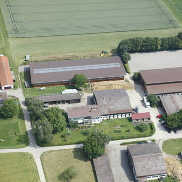
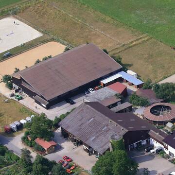
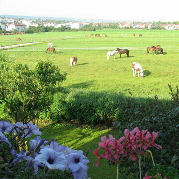
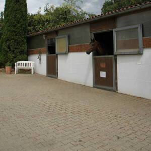
Reitstall Schuler
K-Münchingen
Rainer-Schuler
@Rainer-Schuler
Pferdeausbildung
Reitlehrer und -unterricht
Laufband
Paddock
Pferdezucht
Zuchtstutenhaltung möglich
Außenbox mit Paddock
Außenboxen
14 weitere...
S
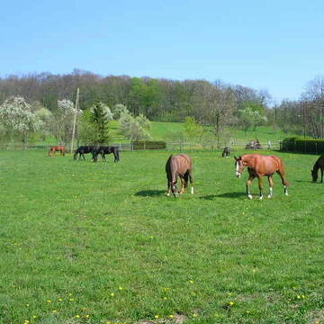
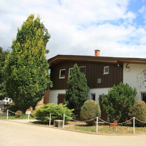
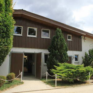
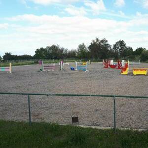
Talhof Korntal
Korntal
Talhof-Korntal
@Talhof-Korntal
FN-Mitglied
Freizeitstall
Vermieten
Führanlage
Hunde willkommen
Pferdezucht
21 weitere...
P+
Deprecated: Creation of dynamic property Zend_View_Helper_Ads::$adLink is deprecated in /var/www/stall-frei/htdocs/staging.stall-frei.de/library/Psf/View/Helper/Ads.php on line 108

Heu aus neuer Ernte
Mechtersen
STALL-FREIde Marketing
@STALL-FREI-Marketing
Heulage und Pferdeheu aus der neuen Ernte findest du in unserem Futtermarkt
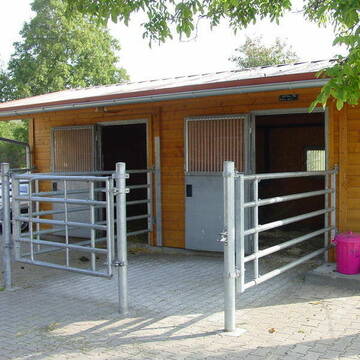
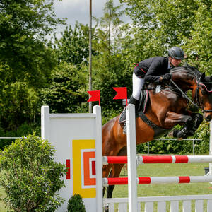
Boxen Frei am Kräherwald
Stuttgart
StuttgarterReit-und-Fahrverein
@StuttgarterReit-und-Fahrverein
Gastronomie
Pferdeausbildung
Vermieten
Führanlage
Hunde willkommen
Einhornhaltung möglich
Hengsthaltung möglich
21 weitere...
P

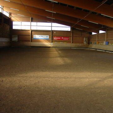
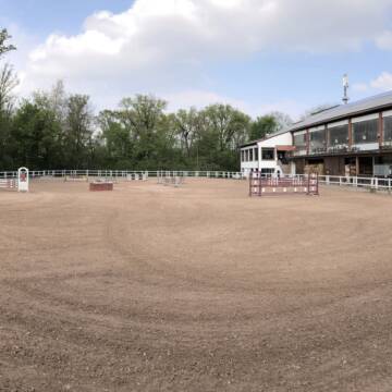
Reitstall Waldhof
Stuttgart
Reitstall Waldhof
@Thomas-Vogel
Freizeitstall
Gastronomie
Vermieten
Hunde willkommen
Paddock
Außenbox mit Paddock
Außenboxen
14 weitere...
P


Wohlfühloase für Pferd und Reiter in Kirchheim/T...
Kirchheim
Wohlfühlstall Asang
@melanie-arnold
Freizeitstall
Wanderreiten
Vermieten
Führanlage
Hunde willkommen
Außenbox mit Paddock
Außenboxen
10 weitere...
aktuell
S

Paddockbox in kleiner Stallgemeinschaft frei
Rutesheim
Carolin-Hoerning
@Carolin-Hoerning
Wir sind ein kleiner Stall mit nur 13 Boxen in Rutesheim.
Aktuell haben wir eine Paddockbox frei.
neu
R


Boxen in Vollpension
Korntal-Münchingen
Strohberghof
@DietmarSchmalzridt
Freizeitstall
Pferdeausbildung
Vermieten
Führanlage
Hunde willkommen
Außenbox mit Paddock
Außenboxen
16 weitere...
P+

Stall Equirena
Fellbach
Stall Equirena
@Stall-Equirena
Fahrstall, Kutschwagen
FN-Mitglied
Vermieten
Hunde willkommen
Krankenbox
Notfallboxen
20 weitere...
P


Pferdeparadies deluxe
Walddorfhäslach
Pferdehof Gaiser
@Pferdehof_Gaiser
Freizeitstall
Geländestrecke
Krankenbox
Laufband
Hufrehe geeignet
Notfallboxen
Außenbox mit Paddock
Außenboxen
19 weitere...
S

Traumbox auf idyllisch gelegener Anlage frei
Stuttgart
Hölzel
@UntereKoerschmuehle
Pferdeausbildung
Reitlehrer und -unterricht
Hunde willkommen
Longierzirkel/Roundpen
Außenboxen
Biofutter
Vollpension
13 weitere...
P
Reitstall Krämer-Kurt Krämer
Schwieberdingen
Reitstall Krämer
@Reitstall-Kraemer
FN-Mitglied
Freizeitstall
Vermieten
Führanlage
Longierzirkel/Roundpen
Außenbox mit Paddock
Außenboxen
18 weitere...
P+
Deprecated: Creation of dynamic property Zend_View::$pageCount is deprecated in /var/www/stall-frei/htdocs/staging.stall-frei.de/library/vendor/shardj/zf1-future/library/Zend/View/Abstract.php on line 308
Deprecated: Creation of dynamic property Zend_View::$itemCountPerPage is deprecated in /var/www/stall-frei/htdocs/staging.stall-frei.de/library/vendor/shardj/zf1-future/library/Zend/View/Abstract.php on line 308
Deprecated: Creation of dynamic property Zend_View::$first is deprecated in /var/www/stall-frei/htdocs/staging.stall-frei.de/library/vendor/shardj/zf1-future/library/Zend/View/Abstract.php on line 308
Deprecated: Creation of dynamic property Zend_View::$current is deprecated in /var/www/stall-frei/htdocs/staging.stall-frei.de/library/vendor/shardj/zf1-future/library/Zend/View/Abstract.php on line 308
Deprecated: Creation of dynamic property Zend_View::$last is deprecated in /var/www/stall-frei/htdocs/staging.stall-frei.de/library/vendor/shardj/zf1-future/library/Zend/View/Abstract.php on line 308
Deprecated: Creation of dynamic property Zend_View::$next is deprecated in /var/www/stall-frei/htdocs/staging.stall-frei.de/library/vendor/shardj/zf1-future/library/Zend/View/Abstract.php on line 308
Deprecated: Creation of dynamic property Zend_View::$pagesInRange is deprecated in /var/www/stall-frei/htdocs/staging.stall-frei.de/library/vendor/shardj/zf1-future/library/Zend/View/Abstract.php on line 308
Deprecated: Creation of dynamic property Zend_View::$firstPageInRange is deprecated in /var/www/stall-frei/htdocs/staging.stall-frei.de/library/vendor/shardj/zf1-future/library/Zend/View/Abstract.php on line 308
Deprecated: Creation of dynamic property Zend_View::$lastPageInRange is deprecated in /var/www/stall-frei/htdocs/staging.stall-frei.de/library/vendor/shardj/zf1-future/library/Zend/View/Abstract.php on line 308
Deprecated: Creation of dynamic property Zend_View::$currentItemCount is deprecated in /var/www/stall-frei/htdocs/staging.stall-frei.de/library/vendor/shardj/zf1-future/library/Zend/View/Abstract.php on line 308
Deprecated: Creation of dynamic property Zend_View::$totalItemCount is deprecated in /var/www/stall-frei/htdocs/staging.stall-frei.de/library/vendor/shardj/zf1-future/library/Zend/View/Abstract.php on line 308
Deprecated: Creation of dynamic property Zend_View::$firstItemNumber is deprecated in /var/www/stall-frei/htdocs/staging.stall-frei.de/library/vendor/shardj/zf1-future/library/Zend/View/Abstract.php on line 308
Deprecated: Creation of dynamic property Zend_View::$lastItemNumber is deprecated in /var/www/stall-frei/htdocs/staging.stall-frei.de/library/vendor/shardj/zf1-future/library/Zend/View/Abstract.php on line 308
Deprecated: Creation of dynamic property Zend_View::$router is deprecated in /var/www/stall-frei/htdocs/staging.stall-frei.de/library/vendor/shardj/zf1-future/library/Zend/View/Abstract.php on line 308
Deprecated: Creation of dynamic property Zend_View::$urlParams is deprecated in /var/www/stall-frei/htdocs/staging.stall-frei.de/library/vendor/shardj/zf1-future/library/Zend/View/Abstract.php on line 308
Deprecated: Creation of dynamic property Zend_View::$showAds is deprecated in /var/www/stall-frei/htdocs/staging.stall-frei.de/library/vendor/shardj/zf1-future/library/Zend/View/Abstract.php on line 308
Deprecated: Creation of dynamic property Zend_View::$objectIds is deprecated in /var/www/stall-frei/htdocs/staging.stall-frei.de/library/vendor/shardj/zf1-future/library/Zend/View/Abstract.php on line 308
Deprecated: Creation of dynamic property Zend_View::$showNavbar is deprecated in /var/www/stall-frei/htdocs/staging.stall-frei.de/library/vendor/shardj/zf1-future/library/Zend/View/Abstract.php on line 308
Deprecated: Creation of dynamic property Zend_View::$showBreadcrumb is deprecated in /var/www/stall-frei/htdocs/staging.stall-frei.de/library/vendor/shardj/zf1-future/library/Zend/View/Abstract.php on line 308
Deprecated: Creation of dynamic property Zend_View::$showFooter is deprecated in /var/www/stall-frei/htdocs/staging.stall-frei.de/library/vendor/shardj/zf1-future/library/Zend/View/Abstract.php on line 308
Deprecated: Creation of dynamic property Zend_View::$showInternalAds is deprecated in /var/www/stall-frei/htdocs/staging.stall-frei.de/library/vendor/shardj/zf1-future/library/Zend/View/Abstract.php on line 308
Deprecated: Creation of dynamic property Zend_View::$blNoContent is deprecated in /var/www/stall-frei/htdocs/staging.stall-frei.de/library/vendor/shardj/zf1-future/library/Zend/View/Abstract.php on line 308
Deprecated: Creation of dynamic property Zend_View::$sMetaDesc is deprecated in /var/www/stall-frei/htdocs/staging.stall-frei.de/library/vendor/shardj/zf1-future/library/Zend/View/Abstract.php on line 308
Deprecated: Creation of dynamic property Zend_View::$useGmaps is deprecated in /var/www/stall-frei/htdocs/staging.stall-frei.de/library/vendor/shardj/zf1-future/library/Zend/View/Abstract.php on line 308
Deprecated: Creation of dynamic property Zend_View::$touches is deprecated in /var/www/stall-frei/htdocs/staging.stall-frei.de/library/vendor/shardj/zf1-future/library/Zend/View/Abstract.php on line 308
Deprecated: Creation of dynamic property Zend_View::$oProject is deprecated in /var/www/stall-frei/htdocs/staging.stall-frei.de/library/vendor/shardj/zf1-future/library/Zend/View/Abstract.php on line 308
Deprecated: Creation of dynamic property Zend_View::$pageHeadline is deprecated in /var/www/stall-frei/htdocs/staging.stall-frei.de/library/vendor/shardj/zf1-future/library/Zend/View/Abstract.php on line 308
Deprecated: Creation of dynamic property Zend_View::$disableLocationField is deprecated in /var/www/stall-frei/htdocs/staging.stall-frei.de/library/vendor/shardj/zf1-future/library/Zend/View/Abstract.php on line 308
Deprecated: Creation of dynamic property Zend_View::$isSearch is deprecated in /var/www/stall-frei/htdocs/staging.stall-frei.de/library/vendor/shardj/zf1-future/library/Zend/View/Abstract.php on line 308
Deprecated: Creation of dynamic property Zend_View::$pageTitle is deprecated in /var/www/stall-frei/htdocs/staging.stall-frei.de/library/vendor/shardj/zf1-future/library/Zend/View/Abstract.php on line 308
Deprecated: Creation of dynamic property Psf_Form_Element_Text::$class is deprecated in /var/www/stall-frei/htdocs/staging.stall-frei.de/library/vendor/shardj/zf1-future/library/Zend/Form/Element.php on line 874
Deprecated: Creation of dynamic property Psf_Form_Element_Text::$size is deprecated in /var/www/stall-frei/htdocs/staging.stall-frei.de/library/vendor/shardj/zf1-future/library/Zend/Form/Element.php on line 874
Deprecated: Creation of dynamic property Psf_Form_Element_Text::$placeholder is deprecated in /var/www/stall-frei/htdocs/staging.stall-frei.de/library/vendor/shardj/zf1-future/library/Zend/Form/Element.php on line 874
Deprecated: Creation of dynamic property Psf_Form_Element_Hidden::$class is deprecated in /var/www/stall-frei/htdocs/staging.stall-frei.de/library/vendor/shardj/zf1-future/library/Zend/Form/Element.php on line 874
Deprecated: Creation of dynamic property Psf_Form_Element_Hidden::$class is deprecated in /var/www/stall-frei/htdocs/staging.stall-frei.de/library/vendor/shardj/zf1-future/library/Zend/Form/Element.php on line 874
Deprecated: Creation of dynamic property Psf_Form_Element_Hidden::$class is deprecated in /var/www/stall-frei/htdocs/staging.stall-frei.de/library/vendor/shardj/zf1-future/library/Zend/Form/Element.php on line 874
Deprecated: Creation of dynamic property Psf_Form_Element_Hidden::$class is deprecated in /var/www/stall-frei/htdocs/staging.stall-frei.de/library/vendor/shardj/zf1-future/library/Zend/Form/Element.php on line 874
Deprecated: Creation of dynamic property Psf_Form_Element_Select::$class is deprecated in /var/www/stall-frei/htdocs/staging.stall-frei.de/library/vendor/shardj/zf1-future/library/Zend/Form/Element.php on line 874
Deprecated: Creation of dynamic property Psf_Form_Element_Select::$class is deprecated in /var/www/stall-frei/htdocs/staging.stall-frei.de/library/vendor/shardj/zf1-future/library/Zend/Form/Element.php on line 874
Deprecated: Creation of dynamic property Psf_Form_Element_Select::$class is deprecated in /var/www/stall-frei/htdocs/staging.stall-frei.de/library/vendor/shardj/zf1-future/library/Zend/Form/Element.php on line 874
Deprecated: Creation of dynamic property Psf_Form_Element_Select::$class is deprecated in /var/www/stall-frei/htdocs/staging.stall-frei.de/library/vendor/shardj/zf1-future/library/Zend/Form/Element.php on line 874
Deprecated: Creation of dynamic property Psf_Form_Element_Text::$class is deprecated in /var/www/stall-frei/htdocs/staging.stall-frei.de/library/vendor/shardj/zf1-future/library/Zend/Form/Element.php on line 874
Deprecated: Creation of dynamic property Psf_Form_Element_Checkbox::$label is deprecated in /var/www/stall-frei/htdocs/staging.stall-frei.de/library/vendor/shardj/zf1-future/library/Zend/Form/Element.php on line 874
Deprecated: Creation of dynamic property Zend_View::$sort is deprecated in /var/www/stall-frei/htdocs/staging.stall-frei.de/library/vendor/shardj/zf1-future/library/Zend/View/Abstract.php on line 308
Deprecated: Creation of dynamic property Zend_View::$searchLocation is deprecated in /var/www/stall-frei/htdocs/staging.stall-frei.de/library/vendor/shardj/zf1-future/library/Zend/View/Abstract.php on line 308
Deprecated: Creation of dynamic property Zend_View::$locationHint is deprecated in /var/www/stall-frei/htdocs/staging.stall-frei.de/library/vendor/shardj/zf1-future/library/Zend/View/Abstract.php on line 308
Psf_GeoCoder_Abstract::getLocation: Uhlandshöhe Get Location CachedOrLive
Psf_GeoCoder_Abstract::getCachedOrLive: Uhlandshöhe
Psf_GeoCoder_OpenCageData::makeApiRequest: response:
Array
(
[documentation] => https://opencagedata.com/api
[licenses] => Array
(
[0] => Array
(
[name] => see attribution guide
[url] => https://opencagedata.com/credits
)
)
[results] => Array
(
[0] => Array
(
[bounds] => Array
(
[northeast] => Array
(
[lat] => 48.7856661
[lng] => 9.2023847
)
[southwest] => Array
(
[lat] => 48.7789777
[lng] => 9.1913697
)
)
[components] => Array
(
[ISO_3166-1_alpha-2] => DE
[ISO_3166-1_alpha-3] => DEU
[ISO_3166-2] => Array
(
[0] => DE-BW
)
[_category] => place
[_normalized_city] => Stuttgart
[_type] => neighbourhood
[city] => Stuttgart
[city_district] => Stuttgart-Ost
[continent] => Europe
[country] => Deutschland
[country_code] => de
[political_union] => European Union
[state] => Baden-Württemberg
[state_code] => BW
[suburb] => Uhlandshöhe
)
[confidence] => 9
[formatted] => Uhlandshöhe, Stuttgart, Baden-Württemberg, Deutschland
[geometry] => Array
(
[lat] => 48.7823371
[lng] => 9.1969667
)
)
[1] => Array
(
[bounds] => Array
(
[northeast] => Array
(
[lat] => 48.7809862
[lng] => 9.1945285
)
[southwest] => Array
(
[lat] => 48.7808862
[lng] => 9.1944285
)
)
[components] => Array
(
[ISO_3166-1_alpha-2] => DE
[ISO_3166-1_alpha-3] => DEU
[ISO_3166-2] => Array
(
[0] => DE-BW
)
[_category] => natural/water
[_normalized_city] => Stuttgart
[_type] => peak
[city] => Stuttgart
[continent] => Europe
[country] => Deutschland
[country_code] => de
[peak] => Uhlandshöhe
[political_union] => European Union
[postcode] => 70184
[state] => Baden-Württemberg
[state_code] => BW
)
[confidence] => 9
[formatted] => Uhlandshöhe, 70184 Stuttgart, Deutschland
[geometry] => Array
(
[lat] => 48.7809362
[lng] => 9.1944785
)
)
[2] => Array
(
[bounds] => Array
(
[northeast] => Array
(
[lat] => 48.7826605
[lng] => 9.1965674
)
[southwest] => Array
(
[lat] => 48.7792199
[lng] => 9.192791
)
)
[components] => Array
(
[ISO_3166-1_alpha-2] => DE
[ISO_3166-1_alpha-3] => DEU
[ISO_3166-2] => Array
(
[0] => DE-BW
)
[_category] => outdoors/recreation
[_normalized_city] => Stuttgart
[_type] => park
[city] => Stuttgart
[city_district] => Stuttgart-Ost
[continent] => Europe
[country] => Deutschland
[country_code] => de
[neighbourhood] => Diemershalde
[park] => Uhlandshöhe
[political_union] => European Union
[postcode] => 70188
[state] => Baden-Württemberg
[state_code] => BW
[suburb] => Uhlandshöhe
)
[confidence] => 9
[formatted] => Uhlandshöhe, 70188 Stuttgart, Deutschland
[geometry] => Array
(
[lat] => 48.7809326
[lng] => 9.1942563
)
)
[3] => Array
(
[bounds] => Array
(
[northeast] => Array
(
[lat] => 48.4043747
[lng] => 8.7670261
)
[southwest] => Array
(
[lat] => 48.4002818
[lng] => 8.7596196
)
)
[components] => Array
(
[ISO_3166-1_alpha-2] => DE
[ISO_3166-1_alpha-3] => DEU
[ISO_3166-2] => Array
(
[0] => DE-BW
)
[_category] => road
[_normalized_city] => Haigerloch
[_type] => road
[continent] => Europe
[country] => Deutschland
[country_code] => de
[county] => Zollernalbkreis
[municipality] => VVG der Stadt Horb am Neckar
[political_union] => European Union
[postcode] => 72401
[road] => Uhlandshöhe
[state] => Baden-Württemberg
[state_code] => BW
[town] => Haigerloch
)
[confidence] => 9
[formatted] => Uhlandshöhe, 72401 Haigerloch, Deutschland
[geometry] => Array
(
[lat] => 48.4033105
[lng] => 8.7627584
)
)
[4] => Array
(
[bounds] => Array
(
[northeast] => Array
(
[lat] => 49.05117
[lng] => 9.2519824
)
[southwest] => Array
(
[lat] => 49.0501425
[lng] => 9.2473954
)
)
[components] => Array
(
[ISO_3166-1_alpha-2] => DE
[ISO_3166-1_alpha-3] => DEU
[ISO_3166-2] => Array
(
[0] => DE-BW
)
[_category] => road
[_normalized_city] => Ilsfeld
[_type] => road
[continent] => Europe
[country] => Deutschland
[country_code] => de
[county] => Landkreis Heilbronn
[municipality] => GVV Schozach-Bottwartal
[political_union] => European Union
[postcode] => 74360
[road] => Uhlandshöhe
[road_type] => residential
[state] => Baden-Württemberg
[state_code] => BW
[village] => Ilsfeld
)
[confidence] => 9
[formatted] => Uhlandshöhe, 74360 Ilsfeld, Deutschland
[geometry] => Array
(
[lat] => 49.0501558
[lng] => 9.2496409
)
)
[5] => Array
(
[bounds] => Array
(
[northeast] => Array
(
[lat] => 48.7129624
[lng] => 8.7455403
)
[southwest] => Array
(
[lat] => 48.7119037
[lng] => 8.743917
)
)
[components] => Array
(
[ISO_3166-1_alpha-2] => DE
[ISO_3166-1_alpha-3] => DEU
[ISO_3166-2] => Array
(
[0] => DE-BW
)
[_category] => road
[_normalized_city] => Calw
[_type] => road
[continent] => Europe
[country] => Deutschland
[country_code] => de
[county] => Landkreis Calw
[municipality] => VVG der Stadt Calw
[political_union] => European Union
[postcode] => 75365
[road] => Uhlandshöhe
[road_type] => residential
[state] => Baden-Württemberg
[state_code] => BW
[suburb] => Wimberg
[town] => Calw
)
[confidence] => 9
[formatted] => Uhlandshöhe, 75365 Calw, Deutschland
[geometry] => Array
(
[lat] => 48.7126318
[lng] => 8.7446368
)
)
[6] => Array
(
[bounds] => Array
(
[northeast] => Array
(
[lat] => 48.4002818
[lng] => 8.7596196
)
[southwest] => Array
(
[lat] => 48.3997569
[lng] => 8.7566807
)
)
[components] => Array
(
[ISO_3166-1_alpha-2] => DE
[ISO_3166-1_alpha-3] => DEU
[ISO_3166-2] => Array
(
[0] => DE-BW
)
[_category] => road
[_normalized_city] => Empfingen
[_type] => road
[city] => Empfingen
[continent] => Europe
[country] => Deutschland
[country_code] => de
[county] => Landkreis Freudenstadt
[municipality] => VVG der Stadt Horb am Neckar
[political_union] => European Union
[postcode] => 72186
[road] => Uhlandshöhe
[state] => Baden-Württemberg
[state_code] => BW
)
[confidence] => 9
[formatted] => Uhlandshöhe, 72186 Empfingen, Deutschland
[geometry] => Array
(
[lat] => 48.4000933
[lng] => 8.7581363
)
)
[7] => Array
(
[bounds] => Array
(
[northeast] => Array
(
[lat] => 49.242925
[lng] => 8.6577777
)
[southwest] => Array
(
[lat] => 49.242462
[lng] => 8.6553762
)
)
[components] => Array
(
[ISO_3166-1_alpha-2] => DE
[ISO_3166-1_alpha-3] => DEU
[ISO_3166-2] => Array
(
[0] => DE-BW
)
[_category] => road
[_normalized_city] => Malsch
[_type] => road
[continent] => Europe
[country] => Deutschland
[country_code] => de
[county] => Rhein-Neckar-Kreis
[municipality] => GVV Rauenberg
[political_union] => European Union
[postcode] => 69254
[road] => Uhlandshöhe
[road_type] => residential
[state] => Baden-Württemberg
[state_code] => BW
[village] => Malsch
)
[confidence] => 9
[formatted] => Uhlandshöhe, 69254 Malsch, Deutschland
[geometry] => Array
(
[lat] => 49.2427063
[lng] => 8.6565707
)
)
[8] => Array
(
[bounds] => Array
(
[northeast] => Array
(
[lat] => 48.40331
[lng] => 8.7690478
)
[southwest] => Array
(
[lat] => 48.4025176
[lng] => 8.7679781
)
)
[components] => Array
(
[ISO_3166-1_alpha-2] => DE
[ISO_3166-1_alpha-3] => DEU
[ISO_3166-2] => Array
(
[0] => DE-BW
)
[_category] => road
[_normalized_city] => Haigerloch
[_type] => road
[continent] => Europe
[country] => Deutschland
[country_code] => de
[county] => Zollernalbkreis
[political_union] => European Union
[postcode] => 72401
[road] => Uhlandshöhe
[road_type] => residential
[state] => Baden-Württemberg
[state_code] => BW
[town] => Haigerloch
[village] => Bad Imnau
)
[confidence] => 9
[formatted] => Uhlandshöhe, 72401 Bad Imnau, Deutschland
[geometry] => Array
(
[lat] => 48.4028452
[lng] => 8.7684643
)
)
[9] => Array
(
[bounds] => Array
(
[northeast] => Array
(
[lat] => 48.6363981
[lng] => 9.1275491
)
[southwest] => Array
(
[lat] => 48.6359271
[lng] => 9.1259485
)
)
[components] => Array
(
[ISO_3166-1_alpha-2] => DE
[ISO_3166-1_alpha-3] => DEU
[ISO_3166-2] => Array
(
[0] => DE-BW
)
[_category] => road
[_normalized_city] => Waldenbuch
[_type] => road
[continent] => Europe
[country] => Deutschland
[country_code] => de
[county] => Landkreis Böblingen
[municipality] => GVV Waldenbuch/Steinenbronn
[political_union] => European Union
[postcode] => 71111
[road] => Uhlandshöhe
[road_type] => residential
[state] => Baden-Württemberg
[state_code] => BW
[town] => Waldenbuch
)
[confidence] => 9
[formatted] => Uhlandshöhe, 71111 Waldenbuch, Deutschland
[geometry] => Array
(
[lat] => 48.6362331
[lng] => 9.1267176
)
)
)
[status] => Array
(
[code] => 200
[message] => OK
)
[stay_informed] => Array
(
[blog] => https://blog.opencagedata.com
[mastodon] => https://en.osm.town/@opencage
)
[thanks] => For using an OpenCage API
[timestamp] => Array
(
[created_http] => Sun, 08 Feb 2026 01:58:39 GMT
[created_unix] => 1770515919
)
[total_results] => 10
)
Psf_GeoCoder_Abstract::convertLocationResult
{"documentation":"https:\/\/opencagedata.com\/api","licenses":[{"name":"see attribution guide","url":"https:\/\/opencagedata.com\/credits"}],"results":[{"bounds":{"northeast":{"lat":48.7856661,"lng":9.2023847},"southwest":{"lat":48.7789777,"lng":9.1913697}},"components":{"ISO_3166-1_alpha-2":"DE","ISO_3166-1_alpha-3":"DEU","ISO_3166-2":["DE-BW"],"_category":"place","_normalized_city":"Stuttgart","_type":"neighbourhood","city":"Stuttgart","city_district":"Stuttgart-Ost","continent":"Europe","country":"Deutschland","country_code":"de","political_union":"European Union","state":"Baden-W\u00fcrttemberg","state_code":"BW","suburb":"Uhlandsh\u00f6he"},"confidence":9,"formatted":"Uhlandsh\u00f6he, Stuttgart, Baden-W\u00fcrttemberg, Deutschland","geometry":{"lat":48.7823371,"lng":9.1969667}},{"bounds":{"northeast":{"lat":48.7809862,"lng":9.1945285},"southwest":{"lat":48.7808862,"lng":9.1944285}},"components":{"ISO_3166-1_alpha-2":"DE","ISO_3166-1_alpha-3":"DEU","ISO_3166-2":["DE-BW"],"_category":"natural\/water","_normalized_city":"Stuttgart","_type":"peak","city":"Stuttgart","continent":"Europe","country":"Deutschland","country_code":"de","peak":"Uhlandsh\u00f6he","political_union":"European Union","postcode":"70184","state":"Baden-W\u00fcrttemberg","state_code":"BW"},"confidence":9,"formatted":"Uhlandsh\u00f6he, 70184 Stuttgart, Deutschland","geometry":{"lat":48.7809362,"lng":9.1944785}},{"bounds":{"northeast":{"lat":48.7826605,"lng":9.1965674},"southwest":{"lat":48.7792199,"lng":9.192791}},"components":{"ISO_3166-1_alpha-2":"DE","ISO_3166-1_alpha-3":"DEU","ISO_3166-2":["DE-BW"],"_category":"outdoors\/recreation","_normalized_city":"Stuttgart","_type":"park","city":"Stuttgart","city_district":"Stuttgart-Ost","continent":"Europe","country":"Deutschland","country_code":"de","neighbourhood":"Diemershalde","park":"Uhlandsh\u00f6he","political_union":"European Union","postcode":"70188","state":"Baden-W\u00fcrttemberg","state_code":"BW","suburb":"Uhlandsh\u00f6he"},"confidence":9,"formatted":"Uhlandsh\u00f6he, 70188 Stuttgart, Deutschland","geometry":{"lat":48.7809326,"lng":9.1942563}},{"bounds":{"northeast":{"lat":48.4043747,"lng":8.7670261},"southwest":{"lat":48.4002818,"lng":8.7596196}},"components":{"ISO_3166-1_alpha-2":"DE","ISO_3166-1_alpha-3":"DEU","ISO_3166-2":["DE-BW"],"_category":"road","_normalized_city":"Haigerloch","_type":"road","continent":"Europe","country":"Deutschland","country_code":"de","county":"Zollernalbkreis","municipality":"VVG der Stadt Horb am Neckar","political_union":"European Union","postcode":"72401","road":"Uhlandsh\u00f6he","state":"Baden-W\u00fcrttemberg","state_code":"BW","town":"Haigerloch"},"confidence":9,"formatted":"Uhlandsh\u00f6he, 72401 Haigerloch, Deutschland","geometry":{"lat":48.4033105,"lng":8.7627584}},{"bounds":{"northeast":{"lat":49.05117,"lng":9.2519824},"southwest":{"lat":49.0501425,"lng":9.2473954}},"components":{"ISO_3166-1_alpha-2":"DE","ISO_3166-1_alpha-3":"DEU","ISO_3166-2":["DE-BW"],"_category":"road","_normalized_city":"Ilsfeld","_type":"road","continent":"Europe","country":"Deutschland","country_code":"de","county":"Landkreis Heilbronn","municipality":"GVV Schozach-Bottwartal","political_union":"European Union","postcode":"74360","road":"Uhlandsh\u00f6he","road_type":"residential","state":"Baden-W\u00fcrttemberg","state_code":"BW","village":"Ilsfeld"},"confidence":9,"formatted":"Uhlandsh\u00f6he, 74360 Ilsfeld, Deutschland","geometry":{"lat":49.0501558,"lng":9.2496409}},{"bounds":{"northeast":{"lat":48.7129624,"lng":8.7455403},"southwest":{"lat":48.7119037,"lng":8.743917}},"components":{"ISO_3166-1_alpha-2":"DE","ISO_3166-1_alpha-3":"DEU","ISO_3166-2":["DE-BW"],"_category":"road","_normalized_city":"Calw","_type":"road","continent":"Europe","country":"Deutschland","country_code":"de","county":"Landkreis Calw","municipality":"VVG der Stadt Calw","political_union":"European Union","postcode":"75365","road":"Uhlandsh\u00f6he","road_type":"residential","state":"Baden-W\u00fcrttemberg","state_code":"BW","suburb":"Wimberg","town":"Calw"},"confidence":9,"formatted":"Uhlandsh\u00f6he, 75365 Calw, Deutschland","geometry":{"lat":48.7126318,"lng":8.7446368}},{"bounds":{"northeast":{"lat":48.4002818,"lng":8.7596196},"southwest":{"lat":48.3997569,"lng":8.7566807}},"components":{"ISO_3166-1_alpha-2":"DE","ISO_3166-1_alpha-3":"DEU","ISO_3166-2":["DE-BW"],"_category":"road","_normalized_city":"Empfingen","_type":"road","city":"Empfingen","continent":"Europe","country":"Deutschland","country_code":"de","county":"Landkreis Freudenstadt","municipality":"VVG der Stadt Horb am Neckar","political_union":"European Union","postcode":"72186","road":"Uhlandsh\u00f6he","state":"Baden-W\u00fcrttemberg","state_code":"BW"},"confidence":9,"formatted":"Uhlandsh\u00f6he, 72186 Empfingen, Deutschland","geometry":{"lat":48.4000933,"lng":8.7581363}},{"bounds":{"northeast":{"lat":49.242925,"lng":8.6577777},"southwest":{"lat":49.242462,"lng":8.6553762}},"components":{"ISO_3166-1_alpha-2":"DE","ISO_3166-1_alpha-3":"DEU","ISO_3166-2":["DE-BW"],"_category":"road","_normalized_city":"Malsch","_type":"road","continent":"Europe","country":"Deutschland","country_code":"de","county":"Rhein-Neckar-Kreis","municipality":"GVV Rauenberg","political_union":"European Union","postcode":"69254","road":"Uhlandsh\u00f6he","road_type":"residential","state":"Baden-W\u00fcrttemberg","state_code":"BW","village":"Malsch"},"confidence":9,"formatted":"Uhlandsh\u00f6he, 69254 Malsch, Deutschland","geometry":{"lat":49.2427063,"lng":8.6565707}},{"bounds":{"northeast":{"lat":48.40331,"lng":8.7690478},"southwest":{"lat":48.4025176,"lng":8.7679781}},"components":{"ISO_3166-1_alpha-2":"DE","ISO_3166-1_alpha-3":"DEU","ISO_3166-2":["DE-BW"],"_category":"road","_normalized_city":"Haigerloch","_type":"road","continent":"Europe","country":"Deutschland","country_code":"de","county":"Zollernalbkreis","political_union":"European Union","postcode":"72401","road":"Uhlandsh\u00f6he","road_type":"residential","state":"Baden-W\u00fcrttemberg","state_code":"BW","town":"Haigerloch","village":"Bad Imnau"},"confidence":9,"formatted":"Uhlandsh\u00f6he, 72401 Bad Imnau, Deutschland","geometry":{"lat":48.4028452,"lng":8.7684643}},{"bounds":{"northeast":{"lat":48.6363981,"lng":9.1275491},"southwest":{"lat":48.6359271,"lng":9.1259485}},"components":{"ISO_3166-1_alpha-2":"DE","ISO_3166-1_alpha-3":"DEU","ISO_3166-2":["DE-BW"],"_category":"road","_normalized_city":"Waldenbuch","_type":"road","continent":"Europe","country":"Deutschland","country_code":"de","county":"Landkreis B\u00f6blingen","municipality":"GVV Waldenbuch\/Steinenbronn","political_union":"European Union","postcode":"71111","road":"Uhlandsh\u00f6he","road_type":"residential","state":"Baden-W\u00fcrttemberg","state_code":"BW","town":"Waldenbuch"},"confidence":9,"formatted":"Uhlandsh\u00f6he, 71111 Waldenbuch, Deutschland","geometry":{"lat":48.6362331,"lng":9.1267176}}],"status":{"code":200,"message":"OK"},"stay_informed":{"blog":"https:\/\/blog.opencagedata.com","mastodon":"https:\/\/en.osm.town\/@opencage"},"thanks":"For using an OpenCage API","timestamp":{"created_http":"Sun, 08 Feb 2026 01:58:39 GMT","created_unix":1770515919},"total_results":10}Array
(
[0] => stdClass Object
(
[bounds] => stdClass Object
(
[northeast] => stdClass Object
(
[lat] => 48.7856661
[lng] => 9.2023847
)
[southwest] => stdClass Object
(
[lat] => 48.7789777
[lng] => 9.1913697
)
)
[components] => stdClass Object
(
[ISO_3166-1_alpha-2] => DE
[ISO_3166-1_alpha-3] => DEU
[ISO_3166-2] => Array
(
[0] => DE-BW
)
[_category] => place
[_normalized_city] => Stuttgart
[_type] => neighbourhood
[city] => Stuttgart
[city_district] => Stuttgart-Ost
[continent] => Europe
[country] => Deutschland
[country_code] => de
[political_union] => European Union
[state] => Baden-Württemberg
[state_code] => BW
[suburb] => Uhlandshöhe
)
[confidence] => 9
[formatted] => Uhlandshöhe, Stuttgart, Baden-Württemberg, Deutschland
[geometry] => stdClass Object
(
[lat] => 48.7823371
[lng] => 9.1969667
)
)
[1] => stdClass Object
(
[bounds] => stdClass Object
(
[northeast] => stdClass Object
(
[lat] => 48.7809862
[lng] => 9.1945285
)
[southwest] => stdClass Object
(
[lat] => 48.7808862
[lng] => 9.1944285
)
)
[components] => stdClass Object
(
[ISO_3166-1_alpha-2] => DE
[ISO_3166-1_alpha-3] => DEU
[ISO_3166-2] => Array
(
[0] => DE-BW
)
[_category] => natural/water
[_normalized_city] => Stuttgart
[_type] => peak
[city] => Stuttgart
[continent] => Europe
[country] => Deutschland
[country_code] => de
[peak] => Uhlandshöhe
[political_union] => European Union
[postcode] => 70184
[state] => Baden-Württemberg
[state_code] => BW
)
[confidence] => 9
[formatted] => Uhlandshöhe, 70184 Stuttgart, Deutschland
[geometry] => stdClass Object
(
[lat] => 48.7809362
[lng] => 9.1944785
)
)
[2] => stdClass Object
(
[bounds] => stdClass Object
(
[northeast] => stdClass Object
(
[lat] => 48.7826605
[lng] => 9.1965674
)
[southwest] => stdClass Object
(
[lat] => 48.7792199
[lng] => 9.192791
)
)
[components] => stdClass Object
(
[ISO_3166-1_alpha-2] => DE
[ISO_3166-1_alpha-3] => DEU
[ISO_3166-2] => Array
(
[0] => DE-BW
)
[_category] => outdoors/recreation
[_normalized_city] => Stuttgart
[_type] => park
[city] => Stuttgart
[city_district] => Stuttgart-Ost
[continent] => Europe
[country] => Deutschland
[country_code] => de
[neighbourhood] => Diemershalde
[park] => Uhlandshöhe
[political_union] => European Union
[postcode] => 70188
[state] => Baden-Württemberg
[state_code] => BW
[suburb] => Uhlandshöhe
)
[confidence] => 9
[formatted] => Uhlandshöhe, 70188 Stuttgart, Deutschland
[geometry] => stdClass Object
(
[lat] => 48.7809326
[lng] => 9.1942563
)
)
[3] => stdClass Object
(
[bounds] => stdClass Object
(
[northeast] => stdClass Object
(
[lat] => 48.4043747
[lng] => 8.7670261
)
[southwest] => stdClass Object
(
[lat] => 48.4002818
[lng] => 8.7596196
)
)
[components] => stdClass Object
(
[ISO_3166-1_alpha-2] => DE
[ISO_3166-1_alpha-3] => DEU
[ISO_3166-2] => Array
(
[0] => DE-BW
)
[_category] => road
[_normalized_city] => Haigerloch
[_type] => road
[continent] => Europe
[country] => Deutschland
[country_code] => de
[county] => Zollernalbkreis
[municipality] => VVG der Stadt Horb am Neckar
[political_union] => European Union
[postcode] => 72401
[road] => Uhlandshöhe
[state] => Baden-Württemberg
[state_code] => BW
[town] => Haigerloch
)
[confidence] => 9
[formatted] => Uhlandshöhe, 72401 Haigerloch, Deutschland
[geometry] => stdClass Object
(
[lat] => 48.4033105
[lng] => 8.7627584
)
)
[4] => stdClass Object
(
[bounds] => stdClass Object
(
[northeast] => stdClass Object
(
[lat] => 49.05117
[lng] => 9.2519824
)
[southwest] => stdClass Object
(
[lat] => 49.0501425
[lng] => 9.2473954
)
)
[components] => stdClass Object
(
[ISO_3166-1_alpha-2] => DE
[ISO_3166-1_alpha-3] => DEU
[ISO_3166-2] => Array
(
[0] => DE-BW
)
[_category] => road
[_normalized_city] => Ilsfeld
[_type] => road
[continent] => Europe
[country] => Deutschland
[country_code] => de
[county] => Landkreis Heilbronn
[municipality] => GVV Schozach-Bottwartal
[political_union] => European Union
[postcode] => 74360
[road] => Uhlandshöhe
[road_type] => residential
[state] => Baden-Württemberg
[state_code] => BW
[village] => Ilsfeld
)
[confidence] => 9
[formatted] => Uhlandshöhe, 74360 Ilsfeld, Deutschland
[geometry] => stdClass Object
(
[lat] => 49.0501558
[lng] => 9.2496409
)
)
[5] => stdClass Object
(
[bounds] => stdClass Object
(
[northeast] => stdClass Object
(
[lat] => 48.7129624
[lng] => 8.7455403
)
[southwest] => stdClass Object
(
[lat] => 48.7119037
[lng] => 8.743917
)
)
[components] => stdClass Object
(
[ISO_3166-1_alpha-2] => DE
[ISO_3166-1_alpha-3] => DEU
[ISO_3166-2] => Array
(
[0] => DE-BW
)
[_category] => road
[_normalized_city] => Calw
[_type] => road
[continent] => Europe
[country] => Deutschland
[country_code] => de
[county] => Landkreis Calw
[municipality] => VVG der Stadt Calw
[political_union] => European Union
[postcode] => 75365
[road] => Uhlandshöhe
[road_type] => residential
[state] => Baden-Württemberg
[state_code] => BW
[suburb] => Wimberg
[town] => Calw
)
[confidence] => 9
[formatted] => Uhlandshöhe, 75365 Calw, Deutschland
[geometry] => stdClass Object
(
[lat] => 48.7126318
[lng] => 8.7446368
)
)
[6] => stdClass Object
(
[bounds] => stdClass Object
(
[northeast] => stdClass Object
(
[lat] => 48.4002818
[lng] => 8.7596196
)
[southwest] => stdClass Object
(
[lat] => 48.3997569
[lng] => 8.7566807
)
)
[components] => stdClass Object
(
[ISO_3166-1_alpha-2] => DE
[ISO_3166-1_alpha-3] => DEU
[ISO_3166-2] => Array
(
[0] => DE-BW
)
[_category] => road
[_normalized_city] => Empfingen
[_type] => road
[city] => Empfingen
[continent] => Europe
[country] => Deutschland
[country_code] => de
[county] => Landkreis Freudenstadt
[municipality] => VVG der Stadt Horb am Neckar
[political_union] => European Union
[postcode] => 72186
[road] => Uhlandshöhe
[state] => Baden-Württemberg
[state_code] => BW
)
[confidence] => 9
[formatted] => Uhlandshöhe, 72186 Empfingen, Deutschland
[geometry] => stdClass Object
(
[lat] => 48.4000933
[lng] => 8.7581363
)
)
[7] => stdClass Object
(
[bounds] => stdClass Object
(
[northeast] => stdClass Object
(
[lat] => 49.242925
[lng] => 8.6577777
)
[southwest] => stdClass Object
(
[lat] => 49.242462
[lng] => 8.6553762
)
)
[components] => stdClass Object
(
[ISO_3166-1_alpha-2] => DE
[ISO_3166-1_alpha-3] => DEU
[ISO_3166-2] => Array
(
[0] => DE-BW
)
[_category] => road
[_normalized_city] => Malsch
[_type] => road
[continent] => Europe
[country] => Deutschland
[country_code] => de
[county] => Rhein-Neckar-Kreis
[municipality] => GVV Rauenberg
[political_union] => European Union
[postcode] => 69254
[road] => Uhlandshöhe
[road_type] => residential
[state] => Baden-Württemberg
[state_code] => BW
[village] => Malsch
)
[confidence] => 9
[formatted] => Uhlandshöhe, 69254 Malsch, Deutschland
[geometry] => stdClass Object
(
[lat] => 49.2427063
[lng] => 8.6565707
)
)
[8] => stdClass Object
(
[bounds] => stdClass Object
(
[northeast] => stdClass Object
(
[lat] => 48.40331
[lng] => 8.7690478
)
[southwest] => stdClass Object
(
[lat] => 48.4025176
[lng] => 8.7679781
)
)
[components] => stdClass Object
(
[ISO_3166-1_alpha-2] => DE
[ISO_3166-1_alpha-3] => DEU
[ISO_3166-2] => Array
(
[0] => DE-BW
)
[_category] => road
[_normalized_city] => Haigerloch
[_type] => road
[continent] => Europe
[country] => Deutschland
[country_code] => de
[county] => Zollernalbkreis
[political_union] => European Union
[postcode] => 72401
[road] => Uhlandshöhe
[road_type] => residential
[state] => Baden-Württemberg
[state_code] => BW
[town] => Haigerloch
[village] => Bad Imnau
)
[confidence] => 9
[formatted] => Uhlandshöhe, 72401 Bad Imnau, Deutschland
[geometry] => stdClass Object
(
[lat] => 48.4028452
[lng] => 8.7684643
)
)
[9] => stdClass Object
(
[bounds] => stdClass Object
(
[northeast] => stdClass Object
(
[lat] => 48.6363981
[lng] => 9.1275491
)
[southwest] => stdClass Object
(
[lat] => 48.6359271
[lng] => 9.1259485
)
)
[components] => stdClass Object
(
[ISO_3166-1_alpha-2] => DE
[ISO_3166-1_alpha-3] => DEU
[ISO_3166-2] => Array
(
[0] => DE-BW
)
[_category] => road
[_normalized_city] => Waldenbuch
[_type] => road
[continent] => Europe
[country] => Deutschland
[country_code] => de
[county] => Landkreis Böblingen
[municipality] => GVV Waldenbuch/Steinenbronn
[political_union] => European Union
[postcode] => 71111
[road] => Uhlandshöhe
[road_type] => residential
[state] => Baden-Württemberg
[state_code] => BW
[town] => Waldenbuch
)
[confidence] => 9
[formatted] => Uhlandshöhe, 71111 Waldenbuch, Deutschland
[geometry] => stdClass Object
(
[lat] => 48.6362331
[lng] => 9.1267176
)
)
)
Psf_GeoCoder_OpenCageData::getKeyMap: 0
stdClass Object
(
    [bounds] => stdClass Object
        (
            [northeast] => stdClass Object
                (
                    [lat] => 48.7856661
                    [lng] => 9.2023847
                )

            [southwest] => stdClass Object
                (
                    [lat] => 48.7789777
                    [lng] => 9.1913697
                )

        )

    [components] => stdClass Object
        (
            [ISO_3166-1_alpha-2] => DE
            [ISO_3166-1_alpha-3] => DEU
            [ISO_3166-2] => Array
                (
                    [0] => DE-BW
                )

            [_category] => place
            [_normalized_city] => Stuttgart
            [_type] => neighbourhood
            [city] => Stuttgart
            [city_district] => Stuttgart-Ost
            [continent] => Europe
            [country] => Deutschland
            [country_code] => de
            [political_union] => European Union
            [state] => Baden-Württemberg
            [state_code] => BW
            [suburb] => Uhlandshöhe
        )

    [confidence] => 9
    [formatted] => Uhlandshöhe, Stuttgart, Baden-Württemberg, Deutschland
    [geometry] => stdClass Object
        (
            [lat] => 48.7823371
            [lng] => 9.1969667
        )

)
Psf_GeoCoder_OpenCageData::getCounty: Stuttgart
Psf_GeoCoder_OpenCageData::addMissingData REFETCH!
Array
(
    [address] => Uhlandshöhe, Stuttgart, Baden-Württemberg, Deutschland
    [type] => neighbourhood
    [street] =>
    [city] => Uhlandshöhe
    [county] => Stuttgart
    [state] => Baden-Württemberg
    [zip] =>
    [country] => Deutschland
    [suburb] => Uhlandshöhe
    [countrycode] => de
    [latitude] => 48.7823371
    [longitude] => 9.1969667
    [accuracy] => 1
    [confidence] => 9
    [bounds] => stdClass Object
        (
            [northeast] => stdClass Object
                (
                    [lat] => 48.7856661
                    [lng] => 9.2023847
                )

            [southwest] => stdClass Object
                (
                    [lat] => 48.7789777
                    [lng] => 9.1913697
                )

        )

)
reformat!
Array
(
    [address] => Uhlandshöhe, Stuttgart, Baden-Württemberg, Deutschland
    [type] => neighbourhood
    [street] =>
    [city] => Uhlandshöhe
    [county] => Stuttgart
    [state] => Baden-Württemberg
    [zip] =>
    [country] => Deutschland
    [suburb] => Uhlandshöhe
    [countrycode] => de
    [latitude] => 48.7823371
    [longitude] => 9.1969667
    [accuracy] => 1
    [confidence] => 9
    [bounds] => stdClass Object
        (
            [northeast] => stdClass Object
                (
                    [lat] => 48.7856661
                    [lng] => 9.2023847
                )

            [southwest] => stdClass Object
                (
                    [lat] => 48.7789777
                    [lng] => 9.1913697
                )

        )

    [place] => Uhlandshöhe, Baden-Württemberg
    [hash] => 453e5e76d840a38769e12fb99f3efdef
)
Psf_GeoCoder_OpenCageData::getKeyMap: 1
stdClass Object
(
    [bounds] => stdClass Object
        (
            [northeast] => stdClass Object
                (
                    [lat] => 48.7809862
                    [lng] => 9.1945285
                )

            [southwest] => stdClass Object
                (
                    [lat] => 48.7808862
                    [lng] => 9.1944285
                )

        )

    [components] => stdClass Object
        (
            [ISO_3166-1_alpha-2] => DE
            [ISO_3166-1_alpha-3] => DEU
            [ISO_3166-2] => Array
                (
                    [0] => DE-BW
                )

            [_category] => natural/water
            [_normalized_city] => Stuttgart
            [_type] => peak
            [city] => Stuttgart
            [continent] => Europe
            [country] => Deutschland
            [country_code] => de
            [peak] => Uhlandshöhe
            [political_union] => European Union
            [postcode] => 70184
            [state] => Baden-Württemberg
            [state_code] => BW
        )

    [confidence] => 9
    [formatted] => Uhlandshöhe, 70184 Stuttgart, Deutschland
    [geometry] => stdClass Object
        (
            [lat] => 48.7809362
            [lng] => 9.1944785
        )

)
Psf_GeoCoder_OpenCageData::getCounty: Stuttgart
Psf_GeoCoder_OpenCageData::addMissingData REFETCH!
Array
(
    [address] => Uhlandshöhe, 70184 Stuttgart, Deutschland
    [type] => peak
    [street] =>
    [city] => Stuttgart
    [county] => Stuttgart
    [state] => Baden-Württemberg
    [zip] => 70184
    [country] => Deutschland
    [suburb] =>
    [countrycode] => de
    [latitude] => 48.7809362
    [longitude] => 9.1944785
    [accuracy] => 1
    [confidence] => 9
    [bounds] => stdClass Object
        (
            [northeast] => stdClass Object
                (
                    [lat] => 48.7809862
                    [lng] => 9.1945285
                )

            [southwest] => stdClass Object
                (
                    [lat] => 48.7808862
                    [lng] => 9.1944285
                )

        )

)
reformat!
Array
(
    [address] => Uhlandshöhe, 70184 Stuttgart, Deutschland
    [type] => peak
    [street] =>
    [city] => Stuttgart
    [county] => Stuttgart
    [state] => Baden-Württemberg
    [zip] => 70184
    [country] => Deutschland
    [suburb] =>
    [countrycode] => de
    [latitude] => 48.7809362
    [longitude] => 9.1944785
    [accuracy] => 1
    [confidence] => 9
    [bounds] => stdClass Object
        (
            [northeast] => stdClass Object
                (
                    [lat] => 48.7809862
                    [lng] => 9.1945285
                )

            [southwest] => stdClass Object
                (
                    [lat] => 48.7808862
                    [lng] => 9.1944285
                )

        )

    [place] => 70184 Stuttgart, Baden-Württemberg
    [hash] => c15a2f827ff3285367adc07d8fcb7dc7
)
Psf_GeoCoder_OpenCageData::getKeyMap: 2
stdClass Object
(
    [bounds] => stdClass Object
        (
            [northeast] => stdClass Object
                (
                    [lat] => 48.7826605
                    [lng] => 9.1965674
                )

            [southwest] => stdClass Object
                (
                    [lat] => 48.7792199
                    [lng] => 9.192791
                )

        )

    [components] => stdClass Object
        (
            [ISO_3166-1_alpha-2] => DE
            [ISO_3166-1_alpha-3] => DEU
            [ISO_3166-2] => Array
                (
                    [0] => DE-BW
                )

            [_category] => outdoors/recreation
            [_normalized_city] => Stuttgart
            [_type] => park
            [city] => Stuttgart
            [city_district] => Stuttgart-Ost
            [continent] => Europe
            [country] => Deutschland
            [country_code] => de
            [neighbourhood] => Diemershalde
            [park] => Uhlandshöhe
            [political_union] => European Union
            [postcode] => 70188
            [state] => Baden-Württemberg
            [state_code] => BW
            [suburb] => Uhlandshöhe
        )

    [confidence] => 9
    [formatted] => Uhlandshöhe, 70188 Stuttgart, Deutschland
    [geometry] => stdClass Object
        (
            [lat] => 48.7809326
            [lng] => 9.1942563
        )

)
Psf_GeoCoder_OpenCageData::getCounty: Stuttgart
Psf_GeoCoder_OpenCageData::addMissingData REFETCH!
Array
(
    [address] => Uhlandshöhe, 70188 Stuttgart, Deutschland
    [type] => park
    [street] =>
    [city] => Uhlandshöhe
    [county] => Stuttgart
    [state] => Baden-Württemberg
    [zip] => 70188
    [country] => Deutschland
    [suburb] => Uhlandshöhe
    [countrycode] => de
    [latitude] => 48.7809326
    [longitude] => 9.1942563
    [accuracy] => 1
    [confidence] => 9
    [bounds] => stdClass Object
        (
            [northeast] => stdClass Object
                (
                    [lat] => 48.7826605
                    [lng] => 9.1965674
                )

            [southwest] => stdClass Object
                (
                    [lat] => 48.7792199
                    [lng] => 9.192791
                )

        )

)
reformat!
Array
(
    [address] => Uhlandshöhe, 70188 Stuttgart, Deutschland
    [type] => park
    [street] =>
    [city] => Uhlandshöhe
    [county] => Stuttgart
    [state] => Baden-Württemberg
    [zip] => 70188
    [country] => Deutschland
    [suburb] => Uhlandshöhe
    [countrycode] => de
    [latitude] => 48.7809326
    [longitude] => 9.1942563
    [accuracy] => 1
    [confidence] => 9
    [bounds] => stdClass Object
        (
            [northeast] => stdClass Object
                (
                    [lat] => 48.7826605
                    [lng] => 9.1965674
                )

            [southwest] => stdClass Object
                (
                    [lat] => 48.7792199
                    [lng] => 9.192791
                )

        )

    [place] => 70188 Uhlandshöhe, Baden-Württemberg
    [hash] => 581a2aad3c7a3484724feefae2031ff0
)
Psf_GeoCoder_OpenCageData::getKeyMap: 3
stdClass Object
(
    [bounds] => stdClass Object
        (
            [northeast] => stdClass Object
                (
                    [lat] => 48.4043747
                    [lng] => 8.7670261
                )

            [southwest] => stdClass Object
                (
                    [lat] => 48.4002818
                    [lng] => 8.7596196
                )

        )

    [components] => stdClass Object
        (
            [ISO_3166-1_alpha-2] => DE
            [ISO_3166-1_alpha-3] => DEU
            [ISO_3166-2] => Array
                (
                    [0] => DE-BW
                )

            [_category] => road
            [_normalized_city] => Haigerloch
            [_type] => road
            [continent] => Europe
            [country] => Deutschland
            [country_code] => de
            [county] => Zollernalbkreis
            [municipality] => VVG der Stadt Horb am Neckar
            [political_union] => European Union
            [postcode] => 72401
            [road] => Uhlandshöhe
            [state] => Baden-Württemberg
            [state_code] => BW
            [town] => Haigerloch
        )

    [confidence] => 9
    [formatted] => Uhlandshöhe, 72401 Haigerloch, Deutschland
    [geometry] => stdClass Object
        (
            [lat] => 48.4033105
            [lng] => 8.7627584
        )

)
Psf_GeoCoder_OpenCageData::getCounty: Zollernalbkreis
Psf_GeoCoder_OpenCageData::addMissingData REFETCH!
Array
(
    [address] => Uhlandshöhe, 72401 Haigerloch, Deutschland
    [type] => road
    [street] => Uhlandshöhe
    [city] => Haigerloch
    [county] => Zollernalbkreis
    [state] => Baden-Württemberg
    [zip] => 72401
    [country] => Deutschland
    [suburb] =>
    [countrycode] => de
    [latitude] => 48.4033105
    [longitude] => 8.7627584
    [accuracy] => 1
    [confidence] => 9
    [bounds] => stdClass Object
        (
            [northeast] => stdClass Object
                (
                    [lat] => 48.4043747
                    [lng] => 8.7670261
                )

            [southwest] => stdClass Object
                (
                    [lat] => 48.4002818
                    [lng] => 8.7596196
                )

        )

)
reformat!
Array
(
    [address] => Uhlandshöhe, 72401 Haigerloch, Deutschland
    [type] => road
    [street] => Uhlandshöhe
    [city] => Haigerloch
    [county] => Zollernalbkreis
    [state] => Baden-Württemberg
    [zip] => 72401
    [country] => Deutschland
    [suburb] =>
    [countrycode] => de
    [latitude] => 48.4033105
    [longitude] => 8.7627584
    [accuracy] => 1
    [confidence] => 9
    [bounds] => stdClass Object
        (
            [northeast] => stdClass Object
                (
                    [lat] => 48.4043747
                    [lng] => 8.7670261
                )

            [southwest] => stdClass Object
                (
                    [lat] => 48.4002818
                    [lng] => 8.7596196
                )

        )

    [place] => Uhlandshöhe, 72401 Haigerloch, Baden-Württemberg
    [hash] => c8b58be2a697ec86ff372383c2b28257
)
Psf_GeoCoder_OpenCageData::getKeyMap: 4
stdClass Object
(
    [bounds] => stdClass Object
        (
            [northeast] => stdClass Object
                (
                    [lat] => 49.05117
                    [lng] => 9.2519824
                )

            [southwest] => stdClass Object
                (
                    [lat] => 49.0501425
                    [lng] => 9.2473954
                )

        )

    [components] => stdClass Object
        (
            [ISO_3166-1_alpha-2] => DE
            [ISO_3166-1_alpha-3] => DEU
            [ISO_3166-2] => Array
                (
                    [0] => DE-BW
                )

            [_category] => road
            [_normalized_city] => Ilsfeld
            [_type] => road
            [continent] => Europe
            [country] => Deutschland
            [country_code] => de
            [county] => Landkreis Heilbronn
            [municipality] => GVV Schozach-Bottwartal
            [political_union] => European Union
            [postcode] => 74360
            [road] => Uhlandshöhe
            [road_type] => residential
            [state] => Baden-Württemberg
            [state_code] => BW
            [village] => Ilsfeld
        )

    [confidence] => 9
    [formatted] => Uhlandshöhe, 74360 Ilsfeld, Deutschland
    [geometry] => stdClass Object
        (
            [lat] => 49.0501558
            [lng] => 9.2496409
        )

)
Psf_GeoCoder_OpenCageData::getCounty: Heilbronn
Psf_GeoCoder_OpenCageData::addMissingData REFETCH!
Array
(
    [address] => Uhlandshöhe, 74360 Ilsfeld, Deutschland
    [type] => road
    [street] => Uhlandshöhe
    [city] => Ilsfeld
    [county] => Heilbronn
    [state] => Baden-Württemberg
    [zip] => 74360
    [country] => Deutschland
    [suburb] =>
    [countrycode] => de
    [latitude] => 49.0501558
    [longitude] => 9.2496409
    [accuracy] => 1
    [confidence] => 9
    [bounds] => stdClass Object
        (
            [northeast] => stdClass Object
                (
                    [lat] => 49.05117
                    [lng] => 9.2519824
                )

            [southwest] => stdClass Object
                (
                    [lat] => 49.0501425
                    [lng] => 9.2473954
                )

        )

)
reformat!
Array
(
    [address] => Uhlandshöhe, 74360 Ilsfeld, Deutschland
    [type] => road
    [street] => Uhlandshöhe
    [city] => Ilsfeld
    [county] => Heilbronn
    [state] => Baden-Württemberg
    [zip] => 74360
    [country] => Deutschland
    [suburb] =>
    [countrycode] => de
    [latitude] => 49.0501558
    [longitude] => 9.2496409
    [accuracy] => 1
    [confidence] => 9
    [bounds] => stdClass Object
        (
            [northeast] => stdClass Object
                (
                    [lat] => 49.05117
                    [lng] => 9.2519824
                )

            [southwest] => stdClass Object
                (
                    [lat] => 49.0501425
                    [lng] => 9.2473954
                )

        )

    [place] => Uhlandshöhe, 74360 Ilsfeld, Baden-Württemberg
    [hash] => 32ac563d1c206ea3d69857ca9cfa1889
)
Psf_GeoCoder_OpenCageData::getKeyMap: 5
stdClass Object
(
    [bounds] => stdClass Object
        (
            [northeast] => stdClass Object
                (
                    [lat] => 48.7129624
                    [lng] => 8.7455403
                )

            [southwest] => stdClass Object
                (
                    [lat] => 48.7119037
                    [lng] => 8.743917
                )

        )

    [components] => stdClass Object
        (
            [ISO_3166-1_alpha-2] => DE
            [ISO_3166-1_alpha-3] => DEU
            [ISO_3166-2] => Array
                (
                    [0] => DE-BW
                )

            [_category] => road
            [_normalized_city] => Calw
            [_type] => road
            [continent] => Europe
            [country] => Deutschland
            [country_code] => de
            [county] => Landkreis Calw
            [municipality] => VVG der Stadt Calw
            [political_union] => European Union
            [postcode] => 75365
            [road] => Uhlandshöhe
            [road_type] => residential
            [state] => Baden-Württemberg
            [state_code] => BW
            [suburb] => Wimberg
            [town] => Calw
        )

    [confidence] => 9
    [formatted] => Uhlandshöhe, 75365 Calw, Deutschland
    [geometry] => stdClass Object
        (
            [lat] => 48.7126318
            [lng] => 8.7446368
        )

)
Psf_GeoCoder_OpenCageData::getCounty: Calw
Psf_GeoCoder_OpenCageData::addMissingData REFETCH!
Array
(
    [address] => Uhlandshöhe, 75365 Calw, Deutschland
    [type] => road
    [street] => Uhlandshöhe
    [city] => Calw
    [county] => Calw
    [state] => Baden-Württemberg
    [zip] => 75365
    [country] => Deutschland
    [suburb] => Wimberg
    [countrycode] => de
    [latitude] => 48.7126318
    [longitude] => 8.7446368
    [accuracy] => 1
    [confidence] => 9
    [bounds] => stdClass Object
        (
            [northeast] => stdClass Object
                (
                    [lat] => 48.7129624
                    [lng] => 8.7455403
                )

            [southwest] => stdClass Object
                (
                    [lat] => 48.7119037
                    [lng] => 8.743917
                )

        )

)
reformat!
Array
(
    [address] => Uhlandshöhe, 75365 Calw, Deutschland
    [type] => road
    [street] => Uhlandshöhe
    [city] => Calw
    [county] => Calw
    [state] => Baden-Württemberg
    [zip] => 75365
    [country] => Deutschland
    [suburb] => Wimberg
    [countrycode] => de
    [latitude] => 48.7126318
    [longitude] => 8.7446368
    [accuracy] => 1
    [confidence] => 9
    [bounds] => stdClass Object
        (
            [northeast] => stdClass Object
                (
                    [lat] => 48.7129624
                    [lng] => 8.7455403
                )

            [southwest] => stdClass Object
                (
                    [lat] => 48.7119037
                    [lng] => 8.743917
                )

        )

    [place] => Uhlandshöhe, 75365 Calw, Baden-Württemberg
    [hash] => 3eae96226e3f9ae31aab8a00c2d87853
)
Psf_GeoCoder_OpenCageData::getKeyMap: 6
stdClass Object
(
    [bounds] => stdClass Object
        (
            [northeast] => stdClass Object
                (
                    [lat] => 48.4002818
                    [lng] => 8.7596196
                )

            [southwest] => stdClass Object
                (
                    [lat] => 48.3997569
                    [lng] => 8.7566807
                )

        )

    [components] => stdClass Object
        (
            [ISO_3166-1_alpha-2] => DE
            [ISO_3166-1_alpha-3] => DEU
            [ISO_3166-2] => Array
                (
                    [0] => DE-BW
                )

            [_category] => road
            [_normalized_city] => Empfingen
            [_type] => road
            [city] => Empfingen
            [continent] => Europe
            [country] => Deutschland
            [country_code] => de
            [county] => Landkreis Freudenstadt
            [municipality] => VVG der Stadt Horb am Neckar
            [political_union] => European Union
            [postcode] => 72186
            [road] => Uhlandshöhe
            [state] => Baden-Württemberg
            [state_code] => BW
        )

    [confidence] => 9
    [formatted] => Uhlandshöhe, 72186 Empfingen, Deutschland
    [geometry] => stdClass Object
        (
            [lat] => 48.4000933
            [lng] => 8.7581363
        )

)
Psf_GeoCoder_OpenCageData::getCounty: Freudenstadt
Psf_GeoCoder_OpenCageData::addMissingData REFETCH!
Array
(
    [address] => Uhlandshöhe, 72186 Empfingen, Deutschland
    [type] => road
    [street] => Uhlandshöhe
    [city] => Empfingen
    [county] => Freudenstadt
    [state] => Baden-Württemberg
    [zip] => 72186
    [country] => Deutschland
    [suburb] =>
    [countrycode] => de
    [latitude] => 48.4000933
    [longitude] => 8.7581363
    [accuracy] => 1
    [confidence] => 9
    [bounds] => stdClass Object
        (
            [northeast] => stdClass Object
                (
                    [lat] => 48.4002818
                    [lng] => 8.7596196
                )

            [southwest] => stdClass Object
                (
                    [lat] => 48.3997569
                    [lng] => 8.7566807
                )

        )

)
reformat!
Array
(
    [address] => Uhlandshöhe, 72186 Empfingen, Deutschland
    [type] => road
    [street] => Uhlandshöhe
    [city] => Empfingen
    [county] => Freudenstadt
    [state] => Baden-Württemberg
    [zip] => 72186
    [country] => Deutschland
    [suburb] =>
    [countrycode] => de
    [latitude] => 48.4000933
    [longitude] => 8.7581363
    [accuracy] => 1
    [confidence] => 9
    [bounds] => stdClass Object
        (
            [northeast] => stdClass Object
                (
                    [lat] => 48.4002818
                    [lng] => 8.7596196
                )

            [southwest] => stdClass Object
                (
                    [lat] => 48.3997569
                    [lng] => 8.7566807
                )

        )

    [place] => Uhlandshöhe, 72186 Empfingen, Baden-Württemberg
    [hash] => aae75bb7bca6def8068a885d9fe68059
)
Psf_GeoCoder_OpenCageData::getKeyMap: 7
stdClass Object
(
    [bounds] => stdClass Object
        (
            [northeast] => stdClass Object
                (
                    [lat] => 49.242925
                    [lng] => 8.6577777
                )

            [southwest] => stdClass Object
                (
                    [lat] => 49.242462
                    [lng] => 8.6553762
                )

        )

    [components] => stdClass Object
        (
            [ISO_3166-1_alpha-2] => DE
            [ISO_3166-1_alpha-3] => DEU
            [ISO_3166-2] => Array
                (
                    [0] => DE-BW
                )

            [_category] => road
            [_normalized_city] => Malsch
            [_type] => road
            [continent] => Europe
            [country] => Deutschland
            [country_code] => de
            [county] => Rhein-Neckar-Kreis
            [municipality] => GVV Rauenberg
            [political_union] => European Union
            [postcode] => 69254
            [road] => Uhlandshöhe
            [road_type] => residential
            [state] => Baden-Württemberg
            [state_code] => BW
            [village] => Malsch
        )

    [confidence] => 9
    [formatted] => Uhlandshöhe, 69254 Malsch, Deutschland
    [geometry] => stdClass Object
        (
            [lat] => 49.2427063
            [lng] => 8.6565707
        )

)
Psf_GeoCoder_OpenCageData::getCounty: Rhein-Neckar-Kreis
Psf_GeoCoder_OpenCageData::addMissingData REFETCH!
Array
(
    [address] => Uhlandshöhe, 69254 Malsch, Deutschland
    [type] => road
    [street] => Uhlandshöhe
    [city] => Malsch
    [county] => Rhein-Neckar-Kreis
    [state] => Baden-Württemberg
    [zip] => 69254
    [country] => Deutschland
    [suburb] =>
    [countrycode] => de
    [latitude] => 49.2427063
    [longitude] => 8.6565707
    [accuracy] => 1
    [confidence] => 9
    [bounds] => stdClass Object
        (
            [northeast] => stdClass Object
                (
                    [lat] => 49.242925
                    [lng] => 8.6577777
                )

            [southwest] => stdClass Object
                (
                    [lat] => 49.242462
                    [lng] => 8.6553762
                )

        )

)
reformat!
Array
(
    [address] => Uhlandshöhe, 69254 Malsch, Deutschland
    [type] => road
    [street] => Uhlandshöhe
    [city] => Malsch
    [county] => Rhein-Neckar-Kreis
    [state] => Baden-Württemberg
    [zip] => 69254
    [country] => Deutschland
    [suburb] =>
    [countrycode] => de
    [latitude] => 49.2427063
    [longitude] => 8.6565707
    [accuracy] => 1
    [confidence] => 9
    [bounds] => stdClass Object
        (
            [northeast] => stdClass Object
                (
                    [lat] => 49.242925
                    [lng] => 8.6577777
                )

            [southwest] => stdClass Object
                (
                    [lat] => 49.242462
                    [lng] => 8.6553762
                )

        )

    [place] => Uhlandshöhe, 69254 Malsch, Baden-Württemberg
    [hash] => 9072eed0f7d22f70f8c751f619090f23
)
Psf_GeoCoder_OpenCageData::getKeyMap: 8
stdClass Object
(
    [bounds] => stdClass Object
        (
            [northeast] => stdClass Object
                (
                    [lat] => 48.40331
                    [lng] => 8.7690478
                )

            [southwest] => stdClass Object
                (
                    [lat] => 48.4025176
                    [lng] => 8.7679781
                )

        )

    [components] => stdClass Object
        (
            [ISO_3166-1_alpha-2] => DE
            [ISO_3166-1_alpha-3] => DEU
            [ISO_3166-2] => Array
                (
                    [0] => DE-BW
                )

            [_category] => road
            [_normalized_city] => Haigerloch
            [_type] => road
            [continent] => Europe
            [country] => Deutschland
            [country_code] => de
            [county] => Zollernalbkreis
            [political_union] => European Union
            [postcode] => 72401
            [road] => Uhlandshöhe
            [road_type] => residential
            [state] => Baden-Württemberg
            [state_code] => BW
            [town] => Haigerloch
            [village] => Bad Imnau
        )

    [confidence] => 9
    [formatted] => Uhlandshöhe, 72401 Bad Imnau, Deutschland
    [geometry] => stdClass Object
        (
            [lat] => 48.4028452
            [lng] => 8.7684643
        )

)
Psf_GeoCoder_OpenCageData::getCounty: Zollernalbkreis
Psf_GeoCoder_OpenCageData::addMissingData REFETCH!
Array
(
    [address] => Uhlandshöhe, 72401 Bad Imnau, Deutschland
    [type] => road
    [street] => Uhlandshöhe
    [city] => Haigerloch
    [county] => Zollernalbkreis
    [state] => Baden-Württemberg
    [zip] => 72401
    [country] => Deutschland
    [suburb] =>
    [countrycode] => de
    [latitude] => 48.4028452
    [longitude] => 8.7684643
    [accuracy] => 1
    [confidence] => 9
    [bounds] => stdClass Object
        (
            [northeast] => stdClass Object
                (
                    [lat] => 48.40331
                    [lng] => 8.7690478
                )

            [southwest] => stdClass Object
                (
                    [lat] => 48.4025176
                    [lng] => 8.7679781
                )

        )

)
reformat!
Array
(
    [address] => Uhlandshöhe, 72401 Haigerloch
    [type] => road
    [street] => Uhlandshöhe
    [city] => Haigerloch
    [county] => Zollernalbkreis
    [state] => Baden-Württemberg
    [zip] => 72401
    [country] => Deutschland
    [suburb] =>
    [countrycode] => de
    [latitude] => 48.4028452
    [longitude] => 8.7684643
    [accuracy] => 1
    [confidence] => 9
    [bounds] => stdClass Object
        (
            [northeast] => stdClass Object
                (
                    [lat] => 48.40331
                    [lng] => 8.7690478
                )

            [southwest] => stdClass Object
                (
                    [lat] => 48.4025176
                    [lng] => 8.7679781
                )

        )

    [place] => Uhlandshöhe, 72401 Haigerloch, Baden-Württemberg
    [hash] => c8b58be2a697ec86ff372383c2b28257
)
Psf_GeoCoder_OpenCageData::getKeyMap: 9
stdClass Object
(
    [bounds] => stdClass Object
        (
            [northeast] => stdClass Object
                (
                    [lat] => 48.6363981
                    [lng] => 9.1275491
                )

            [southwest] => stdClass Object
                (
                    [lat] => 48.6359271
                    [lng] => 9.1259485
                )

        )

    [components] => stdClass Object
        (
            [ISO_3166-1_alpha-2] => DE
            [ISO_3166-1_alpha-3] => DEU
            [ISO_3166-2] => Array
                (
                    [0] => DE-BW
                )

            [_category] => road
            [_normalized_city] => Waldenbuch
            [_type] => road
            [continent] => Europe
            [country] => Deutschland
            [country_code] => de
            [county] => Landkreis Böblingen
            [municipality] => GVV Waldenbuch/Steinenbronn
            [political_union] => European Union
            [postcode] => 71111
            [road] => Uhlandshöhe
            [road_type] => residential
            [state] => Baden-Württemberg
            [state_code] => BW
            [town] => Waldenbuch
        )

    [confidence] => 9
    [formatted] => Uhlandshöhe, 71111 Waldenbuch, Deutschland
    [geometry] => stdClass Object
        (
            [lat] => 48.6362331
            [lng] => 9.1267176
        )

)
Psf_GeoCoder_OpenCageData::getCounty: Böblingen
Psf_GeoCoder_OpenCageData::addMissingData REFETCH!
Array
(
    [address] => Uhlandshöhe, 71111 Waldenbuch, Deutschland
    [type] => road
    [street] => Uhlandshöhe
    [city] => Waldenbuch
    [county] => Böblingen
    [state] => Baden-Württemberg
    [zip] => 71111
    [country] => Deutschland
    [suburb] =>
    [countrycode] => de
    [latitude] => 48.6362331
    [longitude] => 9.1267176
    [accuracy] => 1
    [confidence] => 9
    [bounds] => stdClass Object
        (
            [northeast] => stdClass Object
                (
                    [lat] => 48.6363981
                    [lng] => 9.1275491
                )

            [southwest] => stdClass Object
                (
                    [lat] => 48.6359271
                    [lng] => 9.1259485
                )

        )

)
reformat!
Array
(
    [address] => Uhlandshöhe, 71111 Waldenbuch, Deutschland
    [type] => road
    [street] => Uhlandshöhe
    [city] => Waldenbuch
    [county] => Böblingen
    [state] => Baden-Württemberg
    [zip] => 71111
    [country] => Deutschland
    [suburb] =>
    [countrycode] => de
    [latitude] => 48.6362331
    [longitude] => 9.1267176
    [accuracy] => 1
    [confidence] => 9
    [bounds] => stdClass Object
        (
            [northeast] => stdClass Object
                (
                    [lat] => 48.6363981
                    [lng] => 9.1275491
                )

            [southwest] => stdClass Object
                (
                    [lat] => 48.6359271
                    [lng] => 9.1259485
                )

        )

    [place] => Uhlandshöhe, 71111 Waldenbuch, Baden-Württemberg
    [hash] => d9528024d78d3309f98e008399581c3f
)
Deprecated: Creation of dynamic property Zend_View::$locationHintStyle is deprecated in /var/www/stall-frei/htdocs/staging.stall-frei.de/library/vendor/shardj/zf1-future/library/Zend/View/Abstract.php on line 308
Deprecated: Creation of dynamic property Zend_View::$adGeoLocation is deprecated in /var/www/stall-frei/htdocs/staging.stall-frei.de/library/vendor/shardj/zf1-future/library/Zend/View/Abstract.php on line 308
Deprecated: Creation of dynamic property Zend_View::$recordCount is deprecated in /var/www/stall-frei/htdocs/staging.stall-frei.de/library/vendor/shardj/zf1-future/library/Zend/View/Abstract.php on line 308
Deprecated: explode(): Passing null to parameter #2 ($string) of type string is deprecated in /var/www/stall-frei/htdocs/staging.stall-frei.de/application/models/SearchAgent.php on line 100
Deprecated: explode(): Passing null to parameter #2 ($string) of type string is deprecated in /var/www/stall-frei/htdocs/staging.stall-frei.de/application/models/SearchAgent.php on line 100
Deprecated: explode(): Passing null to parameter #2 ($string) of type string is deprecated in /var/www/stall-frei/htdocs/staging.stall-frei.de/application/models/SearchAgent.php on line 100
Deprecated: explode(): Passing null to parameter #2 ($string) of type string is deprecated in /var/www/stall-frei/htdocs/staging.stall-frei.de/application/models/SearchAgent.php on line 100
Deprecated: explode(): Passing null to parameter #2 ($string) of type string is deprecated in /var/www/stall-frei/htdocs/staging.stall-frei.de/application/models/SearchAgent.php on line 100
Deprecated: explode(): Passing null to parameter #2 ($string) of type string is deprecated in /var/www/stall-frei/htdocs/staging.stall-frei.de/application/models/SearchAgent.php on line 100
Deprecated: explode(): Passing null to parameter #2 ($string) of type string is deprecated in /var/www/stall-frei/htdocs/staging.stall-frei.de/application/models/SearchAgent.php on line 100
Deprecated: explode(): Passing null to parameter #2 ($string) of type string is deprecated in /var/www/stall-frei/htdocs/staging.stall-frei.de/application/models/SearchAgent.php on line 100
Deprecated: explode(): Passing null to parameter #2 ($string) of type string is deprecated in /var/www/stall-frei/htdocs/staging.stall-frei.de/application/models/SearchAgent.php on line 100
Deprecated: trim(): Passing null to parameter #1 ($string) of type string is deprecated in /var/www/stall-frei/htdocs/staging.stall-frei.de/application/models/Account/Search.php on line 82
Warning: Cannot modify header information - headers already sent by (output started at /var/www/stall-frei/htdocs/staging.stall-frei.de/library/vendor/shardj/zf1-future/library/Zend/View/Abstract.php:308) in /var/www/stall-frei/htdocs/staging.stall-frei.de/application/models/Account/Search.php on line 71
Deprecated: Creation of dynamic property Zend_View::$paginationParams is deprecated in /var/www/stall-frei/htdocs/staging.stall-frei.de/library/vendor/shardj/zf1-future/library/Zend/View/Abstract.php on line 308
Deprecated: Creation of dynamic property Zend_View::$objectPaginator is deprecated in /var/www/stall-frei/htdocs/staging.stall-frei.de/library/vendor/shardj/zf1-future/library/Zend/View/Abstract.php on line 308
Deprecated: Creation of dynamic property Zend_View::$featuredObjects is deprecated in /var/www/stall-frei/htdocs/staging.stall-frei.de/library/vendor/shardj/zf1-future/library/Zend/View/Abstract.php on line 308
Deprecated: Creation of dynamic property Zend_View::$hints is deprecated in /var/www/stall-frei/htdocs/staging.stall-frei.de/library/vendor/shardj/zf1-future/library/Zend/View/Abstract.php on line 308
Deprecated: Creation of dynamic property Zend_View::$attributeHints is deprecated in /var/www/stall-frei/htdocs/staging.stall-frei.de/library/vendor/shardj/zf1-future/library/Zend/View/Abstract.php on line 308
Deprecated: Creation of dynamic property Zend_View::$oSearchForm is deprecated in /var/www/stall-frei/htdocs/staging.stall-frei.de/library/vendor/shardj/zf1-future/library/Zend/View/Abstract.php on line 308