Deprecated: Creation of dynamic property Zend_View::$sMode is deprecated in /var/www/stall-frei/htdocs/staging.stall-frei.de/library/vendor/shardj/zf1-future/library/Zend/View/Abstract.php on line 308
Stallplatz oder Offenstall in Lindberg
Gesucht wird in "Lindberg, Bayern, Deutschland"
6.329 Einträge
Deprecated: Creation of dynamic property Zend_View::$listObjects is deprecated in /var/www/stall-frei/htdocs/staging.stall-frei.de/library/vendor/shardj/zf1-future/library/Zend/View/Abstract.php on line 308
Gesponsort


Deprecated: Creation of dynamic property Zend_View::$listMode is deprecated in /var/www/stall-frei/htdocs/staging.stall-frei.de/library/vendor/shardj/zf1-future/library/Zend/View/Abstract.php on line 308
Deprecated: Creation of dynamic property Zend_View::$renderedObjects is deprecated in /var/www/stall-frei/htdocs/staging.stall-frei.de/library/vendor/shardj/zf1-future/library/Zend/View/Abstract.php on line 308
Deprecated: Creation of dynamic property Zend_View::$index is deprecated in /var/www/stall-frei/htdocs/staging.stall-frei.de/library/vendor/shardj/zf1-future/library/Zend/View/Abstract.php on line 308
Deprecated: Creation of dynamic property Zend_View::$displayMode is deprecated in /var/www/stall-frei/htdocs/staging.stall-frei.de/library/vendor/shardj/zf1-future/library/Zend/View/Abstract.php on line 308
Deprecated: Creation of dynamic property Zend_View::$remarketingIds is deprecated in /var/www/stall-frei/htdocs/staging.stall-frei.de/library/vendor/shardj/zf1-future/library/Zend/View/Abstract.php on line 308
Deprecated: Creation of dynamic property Zend_View::$listItem is deprecated in /var/www/stall-frei/htdocs/staging.stall-frei.de/library/vendor/shardj/zf1-future/library/Zend/View/Abstract.php on line 308
Deprecated: Creation of dynamic property Zend_View::$object is deprecated in /var/www/stall-frei/htdocs/staging.stall-frei.de/library/vendor/shardj/zf1-future/library/Zend/View/Abstract.php on line 308
Deprecated: Creation of dynamic property Zend_View::$attributes is deprecated in /var/www/stall-frei/htdocs/staging.stall-frei.de/library/vendor/shardj/zf1-future/library/Zend/View/Abstract.php on line 308


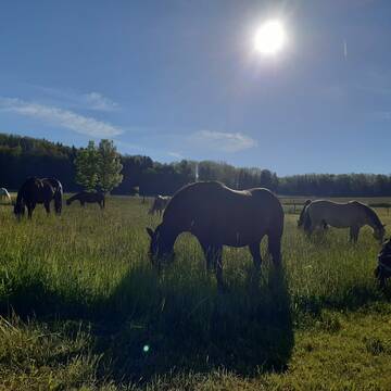
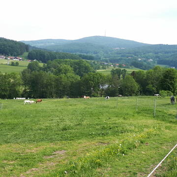
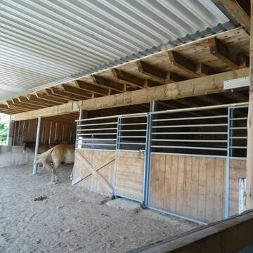
Offenstallplätze/Einstellplätze im Pferdeparadie...
arnbruck
Pferdegut
@Pferdegut
Freizeitstall
Vermieten
Krankenbox
Paddock
Offenstall
6 weitere...
P+
Deprecated: Creation of dynamic property Zend_View_Helper_Ads::$adLink is deprecated in /var/www/stall-frei/htdocs/staging.stall-frei.de/library/Psf/View/Helper/Ads.php on line 108

Futtersack HeuToy, Fressbremse in pink
Mechtersen
STALL-FREIde Marketing
@STALL-FREI-Marketing
Stundenlange Beschäftigung die
Koliken vorbeugt, geringe Staubinhalation mit
steuerbarer Futterentnahme
Leider kein Vorschaubild
Leider kein Vorschaubild
Biete Offenstallplatz
Zachenberg
Wandelmühle
@Wandelmuehle-Zachenberg
Vermieten
Krankenbox
Longierzirkel/Roundpen
Bewegungsstall
Offenstall
HIT-Aktivstall
9 weitere...
B
Zottel Ranch
Grafenau
Zottel-Ranch
@Zottel-Ranch
Freizeitstall
Longierzirkel/Roundpen
Sattelkammer/Sattelschränke
Außenbox mit Paddock
Vollpension
5 weitere...
P


Grosse Boxen , Offenstallplätze
Freyung
Eva Thaler
@Thaler-Hof
Pferdeausbildung
Reitlehrer und -unterricht
Hunde willkommen
Krankenbox
Notfallboxen
Innenbox
Offenstall
10 weitere...
P+

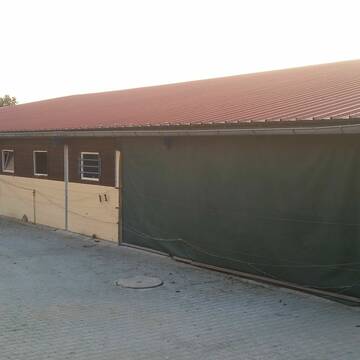
Paddockbox/Innenbox/ Offenstall frei!
Schöllnach
Reitanlage Zitzelsberger
@Reitanlage-Zitzelsberger
Freizeitstall
Pferdeausbildung
Vermieten
Hunde willkommen
Laufband
Fohlenaufzucht möglich
Pferdezucht
21 weitere...
P+

Frisches Stroh zu verkaufen!
Mechtersen
STALL-FREIde Marketing
@STALL-FREI-Marketing
Kaufe frisches Stroh für dein Pferd!
Bewegungsstall, zertifizierter Biobetrieb
Windorf
Johannes-Orthuber
@Johannes-Orthuber
Freizeitstall
Geländestrecke
Vermieten
Hunde willkommen
Krankenbox
Allergikerstall
Gnadenbrothof
21 weitere...
S

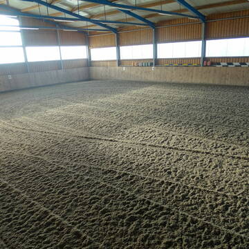
Neueröffnung - matschfreier Offenstall für Stute...
Hohenau
Horseful Living
@Horseful_Living
FN-Mitglied
Freizeitstall
Vermieten
Krankenbox
Paddock
Allergikerstall
Notfallboxen
16 weitere...
P
Pferdestall Rettenbach 1× "gratis Box "...
Saldenburg
Pferdestall-Rettenbach
@Pferdestall-Rettenbach
Geländestrecke
Reitlehrer und -unterricht
Vermieten
Verpachten
Hunde willkommen
Krankenbox
Allergikerstall
Gnadenbrothof
32 weitere...
aktuell
P
Leider kein Vorschaubild
Leider kein Vorschaubild
Paddockboxen zu vermieten
Schaufling
Emmenegger Walter
@Emmenegger
Freizeitstall
Vermieten
Hunde willkommen
Paddock
Außenbox mit Paddock
9 weitere...
B
Pferdeboxen und artenreiche Weidelandschaften
Ringelai
Freizeitreitstall Kapellenhof
@Weidelandschaft
Freizeitstall
Gastronomie
Vermieten
Hunde willkommen
Parkplatz für Pferdeanhänger
Innenbox
17 weitere...
P
Deprecated: Creation of dynamic property Zend_View::$pageCount is deprecated in /var/www/stall-frei/htdocs/staging.stall-frei.de/library/vendor/shardj/zf1-future/library/Zend/View/Abstract.php on line 308
Deprecated: Creation of dynamic property Zend_View::$itemCountPerPage is deprecated in /var/www/stall-frei/htdocs/staging.stall-frei.de/library/vendor/shardj/zf1-future/library/Zend/View/Abstract.php on line 308
Deprecated: Creation of dynamic property Zend_View::$first is deprecated in /var/www/stall-frei/htdocs/staging.stall-frei.de/library/vendor/shardj/zf1-future/library/Zend/View/Abstract.php on line 308
Deprecated: Creation of dynamic property Zend_View::$current is deprecated in /var/www/stall-frei/htdocs/staging.stall-frei.de/library/vendor/shardj/zf1-future/library/Zend/View/Abstract.php on line 308
Deprecated: Creation of dynamic property Zend_View::$last is deprecated in /var/www/stall-frei/htdocs/staging.stall-frei.de/library/vendor/shardj/zf1-future/library/Zend/View/Abstract.php on line 308
Deprecated: Creation of dynamic property Zend_View::$next is deprecated in /var/www/stall-frei/htdocs/staging.stall-frei.de/library/vendor/shardj/zf1-future/library/Zend/View/Abstract.php on line 308
Deprecated: Creation of dynamic property Zend_View::$pagesInRange is deprecated in /var/www/stall-frei/htdocs/staging.stall-frei.de/library/vendor/shardj/zf1-future/library/Zend/View/Abstract.php on line 308
Deprecated: Creation of dynamic property Zend_View::$firstPageInRange is deprecated in /var/www/stall-frei/htdocs/staging.stall-frei.de/library/vendor/shardj/zf1-future/library/Zend/View/Abstract.php on line 308
Deprecated: Creation of dynamic property Zend_View::$lastPageInRange is deprecated in /var/www/stall-frei/htdocs/staging.stall-frei.de/library/vendor/shardj/zf1-future/library/Zend/View/Abstract.php on line 308
Deprecated: Creation of dynamic property Zend_View::$currentItemCount is deprecated in /var/www/stall-frei/htdocs/staging.stall-frei.de/library/vendor/shardj/zf1-future/library/Zend/View/Abstract.php on line 308
Deprecated: Creation of dynamic property Zend_View::$totalItemCount is deprecated in /var/www/stall-frei/htdocs/staging.stall-frei.de/library/vendor/shardj/zf1-future/library/Zend/View/Abstract.php on line 308
Deprecated: Creation of dynamic property Zend_View::$firstItemNumber is deprecated in /var/www/stall-frei/htdocs/staging.stall-frei.de/library/vendor/shardj/zf1-future/library/Zend/View/Abstract.php on line 308
Deprecated: Creation of dynamic property Zend_View::$lastItemNumber is deprecated in /var/www/stall-frei/htdocs/staging.stall-frei.de/library/vendor/shardj/zf1-future/library/Zend/View/Abstract.php on line 308
Deprecated: Creation of dynamic property Zend_View::$router is deprecated in /var/www/stall-frei/htdocs/staging.stall-frei.de/library/vendor/shardj/zf1-future/library/Zend/View/Abstract.php on line 308
Deprecated: Creation of dynamic property Zend_View::$urlParams is deprecated in /var/www/stall-frei/htdocs/staging.stall-frei.de/library/vendor/shardj/zf1-future/library/Zend/View/Abstract.php on line 308
Deprecated: Creation of dynamic property Zend_View::$showAds is deprecated in /var/www/stall-frei/htdocs/staging.stall-frei.de/library/vendor/shardj/zf1-future/library/Zend/View/Abstract.php on line 308
Deprecated: Creation of dynamic property Zend_View::$objectIds is deprecated in /var/www/stall-frei/htdocs/staging.stall-frei.de/library/vendor/shardj/zf1-future/library/Zend/View/Abstract.php on line 308
Deprecated: Creation of dynamic property Zend_View::$showNavbar is deprecated in /var/www/stall-frei/htdocs/staging.stall-frei.de/library/vendor/shardj/zf1-future/library/Zend/View/Abstract.php on line 308
Deprecated: Creation of dynamic property Zend_View::$showBreadcrumb is deprecated in /var/www/stall-frei/htdocs/staging.stall-frei.de/library/vendor/shardj/zf1-future/library/Zend/View/Abstract.php on line 308
Deprecated: Creation of dynamic property Zend_View::$showFooter is deprecated in /var/www/stall-frei/htdocs/staging.stall-frei.de/library/vendor/shardj/zf1-future/library/Zend/View/Abstract.php on line 308
Deprecated: Creation of dynamic property Zend_View::$showInternalAds is deprecated in /var/www/stall-frei/htdocs/staging.stall-frei.de/library/vendor/shardj/zf1-future/library/Zend/View/Abstract.php on line 308
Deprecated: Creation of dynamic property Zend_View::$blNoContent is deprecated in /var/www/stall-frei/htdocs/staging.stall-frei.de/library/vendor/shardj/zf1-future/library/Zend/View/Abstract.php on line 308
Deprecated: Creation of dynamic property Zend_View::$sMetaDesc is deprecated in /var/www/stall-frei/htdocs/staging.stall-frei.de/library/vendor/shardj/zf1-future/library/Zend/View/Abstract.php on line 308
Deprecated: Creation of dynamic property Zend_View::$useGmaps is deprecated in /var/www/stall-frei/htdocs/staging.stall-frei.de/library/vendor/shardj/zf1-future/library/Zend/View/Abstract.php on line 308
Deprecated: Creation of dynamic property Zend_View::$touches is deprecated in /var/www/stall-frei/htdocs/staging.stall-frei.de/library/vendor/shardj/zf1-future/library/Zend/View/Abstract.php on line 308
Deprecated: Creation of dynamic property Zend_View::$oProject is deprecated in /var/www/stall-frei/htdocs/staging.stall-frei.de/library/vendor/shardj/zf1-future/library/Zend/View/Abstract.php on line 308
Deprecated: Creation of dynamic property Zend_View::$pageHeadline is deprecated in /var/www/stall-frei/htdocs/staging.stall-frei.de/library/vendor/shardj/zf1-future/library/Zend/View/Abstract.php on line 308
Deprecated: Creation of dynamic property Zend_View::$disableLocationField is deprecated in /var/www/stall-frei/htdocs/staging.stall-frei.de/library/vendor/shardj/zf1-future/library/Zend/View/Abstract.php on line 308
Deprecated: Creation of dynamic property Zend_View::$isSearch is deprecated in /var/www/stall-frei/htdocs/staging.stall-frei.de/library/vendor/shardj/zf1-future/library/Zend/View/Abstract.php on line 308
Deprecated: Creation of dynamic property Zend_View::$pageTitle is deprecated in /var/www/stall-frei/htdocs/staging.stall-frei.de/library/vendor/shardj/zf1-future/library/Zend/View/Abstract.php on line 308
Deprecated: Creation of dynamic property Psf_Form_Element_Text::$class is deprecated in /var/www/stall-frei/htdocs/staging.stall-frei.de/library/vendor/shardj/zf1-future/library/Zend/Form/Element.php on line 874
Deprecated: Creation of dynamic property Psf_Form_Element_Text::$size is deprecated in /var/www/stall-frei/htdocs/staging.stall-frei.de/library/vendor/shardj/zf1-future/library/Zend/Form/Element.php on line 874
Deprecated: Creation of dynamic property Psf_Form_Element_Text::$placeholder is deprecated in /var/www/stall-frei/htdocs/staging.stall-frei.de/library/vendor/shardj/zf1-future/library/Zend/Form/Element.php on line 874
Deprecated: Creation of dynamic property Psf_Form_Element_Hidden::$class is deprecated in /var/www/stall-frei/htdocs/staging.stall-frei.de/library/vendor/shardj/zf1-future/library/Zend/Form/Element.php on line 874
Deprecated: Creation of dynamic property Psf_Form_Element_Hidden::$class is deprecated in /var/www/stall-frei/htdocs/staging.stall-frei.de/library/vendor/shardj/zf1-future/library/Zend/Form/Element.php on line 874
Deprecated: Creation of dynamic property Psf_Form_Element_Hidden::$class is deprecated in /var/www/stall-frei/htdocs/staging.stall-frei.de/library/vendor/shardj/zf1-future/library/Zend/Form/Element.php on line 874
Deprecated: Creation of dynamic property Psf_Form_Element_Hidden::$class is deprecated in /var/www/stall-frei/htdocs/staging.stall-frei.de/library/vendor/shardj/zf1-future/library/Zend/Form/Element.php on line 874
Deprecated: Creation of dynamic property Psf_Form_Element_Select::$class is deprecated in /var/www/stall-frei/htdocs/staging.stall-frei.de/library/vendor/shardj/zf1-future/library/Zend/Form/Element.php on line 874
Deprecated: Creation of dynamic property Psf_Form_Element_Select::$class is deprecated in /var/www/stall-frei/htdocs/staging.stall-frei.de/library/vendor/shardj/zf1-future/library/Zend/Form/Element.php on line 874
Deprecated: Creation of dynamic property Psf_Form_Element_Select::$class is deprecated in /var/www/stall-frei/htdocs/staging.stall-frei.de/library/vendor/shardj/zf1-future/library/Zend/Form/Element.php on line 874
Deprecated: Creation of dynamic property Psf_Form_Element_Select::$class is deprecated in /var/www/stall-frei/htdocs/staging.stall-frei.de/library/vendor/shardj/zf1-future/library/Zend/Form/Element.php on line 874
Deprecated: Creation of dynamic property Psf_Form_Element_Text::$class is deprecated in /var/www/stall-frei/htdocs/staging.stall-frei.de/library/vendor/shardj/zf1-future/library/Zend/Form/Element.php on line 874
Deprecated: Creation of dynamic property Psf_Form_Element_Checkbox::$label is deprecated in /var/www/stall-frei/htdocs/staging.stall-frei.de/library/vendor/shardj/zf1-future/library/Zend/Form/Element.php on line 874
Deprecated: Creation of dynamic property Zend_View::$sort is deprecated in /var/www/stall-frei/htdocs/staging.stall-frei.de/library/vendor/shardj/zf1-future/library/Zend/View/Abstract.php on line 308
Deprecated: Creation of dynamic property Zend_View::$searchLocation is deprecated in /var/www/stall-frei/htdocs/staging.stall-frei.de/library/vendor/shardj/zf1-future/library/Zend/View/Abstract.php on line 308
Deprecated: Creation of dynamic property Zend_View::$locationHint is deprecated in /var/www/stall-frei/htdocs/staging.stall-frei.de/library/vendor/shardj/zf1-future/library/Zend/View/Abstract.php on line 308
Psf_GeoCoder_Abstract::getLocation: Lindberg Get Location CachedOrLive
Psf_GeoCoder_Abstract::getCachedOrLive: Lindberg
Psf_GeoCoder_OpenCageData::makeApiRequest: response:
Array
(
[documentation] => https://opencagedata.com/api
[licenses] => Array
(
[0] => Array
(
[name] => see attribution guide
[url] => https://opencagedata.com/credits
)
)
[results] => Array
(
[0] => Array
(
[bounds] => Array
(
[northeast] => Array
(
[lat] => 49.1204942
[lng] => 13.4058295
)
[southwest] => Array
(
[lat] => 49.0056249
[lng] => 13.2269767
)
)
[components] => Array
(
[ISO_3166-1_alpha-2] => DE
[ISO_3166-1_alpha-3] => DEU
[ISO_3166-2] => Array
(
[0] => DE-BY
)
[_category] => place
[_normalized_city] => Lindberg
[_type] => village
[continent] => Europe
[country] => Deutschland
[country_code] => de
[county] => Landkreis Regen
[political_union] => European Union
[state] => Bayern
[state_code] => BY
[village] => Lindberg
)
[confidence] => 6
[formatted] => Lindberg, Bayern, Deutschland
[geometry] => Array
(
[lat] => 49.0358044
[lng] => 13.2551472
)
)
[1] => Array
(
[bounds] => Array
(
[northeast] => Array
(
[lat] => 47.9536129
[lng] => 12.1930739
)
[southwest] => Array
(
[lat] => 47.9535129
[lng] => 12.1929739
)
)
[components] => Array
(
[ISO_3166-1_alpha-2] => DE
[ISO_3166-1_alpha-3] => DEU
[ISO_3166-2] => Array
(
[0] => DE-BY
)
[_category] => natural/water
[_normalized_city] => Vogtareuth
[_type] => peak
[continent] => Europe
[country] => Deutschland
[country_code] => de
[county] => Landkreis Rosenheim
[peak] => Lindberg
[political_union] => European Union
[postcode] => 83569
[state] => Bayern
[state_code] => BY
[village] => Vogtareuth
)
[confidence] => 9
[formatted] => Lindberg, 83569 Vogtareuth, Deutschland
[geometry] => Array
(
[lat] => 47.9535629
[lng] => 12.1930239
)
)
[2] => Array
(
[bounds] => Array
(
[northeast] => Array
(
[lat] => 51.6978957
[lng] => 11.3066758
)
[southwest] => Array
(
[lat] => 51.6977957
[lng] => 11.3065758
)
)
[components] => Array
(
[ISO_3166-1_alpha-2] => DE
[ISO_3166-1_alpha-3] => DEU
[ISO_3166-2] => Array
(
[0] => DE-ST
)
[_category] => natural/water
[_normalized_city] => Falkenstein/Harz
[_type] => peak
[continent] => Europe
[country] => Deutschland
[country_code] => de
[county] => Landkreis Harz
[municipality] => Falkenstein/Harz
[peak] => Lindberg
[political_union] => European Union
[postcode] => 06543
[state] => Sachsen-Anhalt
[state_code] => ST
)
[confidence] => 9
[formatted] => Lindberg, 06543 Falkenstein/Harz, Deutschland
[geometry] => Array
(
[lat] => 51.6978457
[lng] => 11.3066258
)
)
[3] => Array
(
[bounds] => Array
(
[northeast] => Array
(
[lat] => 51.6645004
[lng] => 11.371141
)
[southwest] => Array
(
[lat] => 51.6644004
[lng] => 11.371041
)
)
[components] => Array
(
[ISO_3166-1_alpha-2] => DE
[ISO_3166-1_alpha-3] => DEU
[ISO_3166-2] => Array
(
[0] => DE-ST
)
[_category] => natural/water
[_normalized_city] => Arnstein
[_type] => peak
[continent] => Europe
[country] => Deutschland
[country_code] => de
[county] => Mansfeld-Südharz
[peak] => Lindberg
[political_union] => European Union
[state] => Sachsen-Anhalt
[state_code] => ST
[town] => Arnstein
)
[confidence] => 9
[formatted] => Lindberg, Arnstein, Sachsen-Anhalt, Deutschland
[geometry] => Array
(
[lat] => 51.6644504
[lng] => 11.371091
)
)
[4] => Array
(
[bounds] => Array
(
[northeast] => Array
(
[lat] => 48.9726939
[lng] => 8.6729385
)
[southwest] => Array
(
[lat] => 48.9725939
[lng] => 8.6728385
)
)
[components] => Array
(
[ISO_3166-1_alpha-2] => DE
[ISO_3166-1_alpha-3] => DEU
[ISO_3166-2] => Array
(
[0] => DE-BW
)
[_category] => natural/water
[_normalized_city] => Königsbach-Stein
[_type] => peak
[continent] => Europe
[country] => Deutschland
[country_code] => de
[county] => Enzkreis
[municipality] => Königsbach-Stein
[peak] => Lindberg
[political_union] => European Union
[postcode] => 75239
[state] => Baden-Württemberg
[state_code] => BW
)
[confidence] => 9
[formatted] => Lindberg, 75239 Königsbach-Stein, Deutschland
[geometry] => Array
(
[lat] => 48.9726439
[lng] => 8.6728885
)
)
[5] => Array
(
[bounds] => Array
(
[northeast] => Array
(
[lat] => 50.164371
[lng] => 7.6643279
)
[southwest] => Array
(
[lat] => 50.164271
[lng] => 7.6642279
)
)
[components] => Array
(
[ISO_3166-1_alpha-2] => DE
[ISO_3166-1_alpha-3] => DEU
[ISO_3166-2] => Array
(
[0] => DE-RP
)
[_category] => natural/water
[_normalized_city] => Sankt Goar
[_type] => peak
[continent] => Europe
[country] => Deutschland
[country_code] => de
[county] => Rhein-Hunsrück-Kreis
[municipality] => Hunsrück-Mittelrhein
[peak] => Lindberg
[political_union] => European Union
[postcode] => 56346
[state] => Rheinland-Pfalz
[state_code] => RP
[town] => Sankt Goar
)
[confidence] => 9
[formatted] => Lindberg, 56346 Sankt Goar, Deutschland
[geometry] => Array
(
[lat] => 50.164321
[lng] => 7.6642779
)
)
[6] => Array
(
[bounds] => Array
(
[northeast] => Array
(
[lat] => 49.7411981
[lng] => 11.5730734
)
[southwest] => Array
(
[lat] => 49.7410981
[lng] => 11.5729734
)
)
[components] => Array
(
[ISO_3166-1_alpha-2] => DE
[ISO_3166-1_alpha-3] => DEU
[ISO_3166-2] => Array
(
[0] => DE-BY
)
[_category] => natural/water
[_normalized_city] => Pegnitz
[_type] => peak
[continent] => Europe
[country] => Deutschland
[country_code] => de
[county] => Landkreis Bayreuth
[peak] => Lindberg
[political_union] => European Union
[postcode] => 91257
[state] => Bayern
[state_code] => BY
[town] => Pegnitz
)
[confidence] => 9
[formatted] => Lindberg, 91257 Pegnitz, Deutschland
[geometry] => Array
(
[lat] => 49.7411481
[lng] => 11.5730234
)
)
[7] => Array
(
[bounds] => Array
(
[northeast] => Array
(
[lat] => 51.2564929
[lng] => 12.6663864
)
[southwest] => Array
(
[lat] => 51.2563929
[lng] => 12.6662864
)
)
[components] => Array
(
[ISO_3166-1_alpha-2] => DE
[ISO_3166-1_alpha-3] => DEU
[ISO_3166-2] => Array
(
[0] => DE-SN
)
[_category] => natural/water
[_normalized_city] => Parthenstein
[_type] => peak
[city] => Parthenstein
[continent] => Europe
[country] => Deutschland
[country_code] => de
[county] => Landkreis Leipzig
[municipality] => Verwaltungsgemeinschaft Naunhof
[peak] => Lindberg
[political_union] => European Union
[state] => Sachsen
[state_code] => SN
)
[confidence] => 9
[formatted] => Lindberg, Parthenstein, Sachsen, Deutschland
[geometry] => Array
(
[lat] => 51.2564429
[lng] => 12.6663364
)
)
[8] => Array
(
[bounds] => Array
(
[northeast] => Array
(
[lat] => 52.8859808
[lng] => 13.5764025
)
[southwest] => Array
(
[lat] => 52.8858808
[lng] => 13.5763025
)
)
[components] => Array
(
[ISO_3166-1_alpha-2] => DE
[ISO_3166-1_alpha-3] => DEU
[ISO_3166-2] => Array
(
[0] => DE-BB
)
[_category] => natural/water
[_normalized_city] => Klandorf
[_type] => peak
[continent] => Europe
[country] => Deutschland
[country_code] => de
[county] => Barnim
[municipality] => Schorfheide
[peak] => Lindberg
[political_union] => European Union
[state] => Brandenburg
[state_code] => BB
[village] => Klandorf
)
[confidence] => 9
[formatted] => Lindberg, Klandorf, Brandenburg, Deutschland
[geometry] => Array
(
[lat] => 52.8859308
[lng] => 13.5763525
)
)
[9] => Array
(
[bounds] => Array
(
[northeast] => Array
(
[lat] => 48.7897181
[lng] => 13.4345817
)
[southwest] => Array
(
[lat] => 48.7896181
[lng] => 13.4344817
)
)
[components] => Array
(
[ISO_3166-1_alpha-2] => DE
[ISO_3166-1_alpha-3] => DEU
[ISO_3166-2] => Array
(
[0] => DE-BY
)
[_category] => natural/water
[_normalized_city] => Perlesreut
[_type] => peak
[continent] => Europe
[country] => Deutschland
[country_code] => de
[county] => Landkreis Freyung-Grafenau
[municipality] => Perlesreut (VGem)
[peak] => Lindberg
[political_union] => European Union
[postcode] => 94157
[state] => Bayern
[state_code] => BY
[town] => Perlesreut
)
[confidence] => 9
[formatted] => Lindberg, 94157 Perlesreut, Deutschland
[geometry] => Array
(
[lat] => 48.7896681
[lng] => 13.4345317
)
)
)
[status] => Array
(
[code] => 200
[message] => OK
)
[stay_informed] => Array
(
[blog] => https://blog.opencagedata.com
[mastodon] => https://en.osm.town/@opencage
)
[thanks] => For using an OpenCage API
[timestamp] => Array
(
[created_http] => Sat, 07 Feb 2026 22:08:25 GMT
[created_unix] => 1770502105
)
[total_results] => 10
)
Psf_GeoCoder_Abstract::convertLocationResult
{"documentation":"https:\/\/opencagedata.com\/api","licenses":[{"name":"see attribution guide","url":"https:\/\/opencagedata.com\/credits"}],"results":[{"bounds":{"northeast":{"lat":49.1204942,"lng":13.4058295},"southwest":{"lat":49.0056249,"lng":13.2269767}},"components":{"ISO_3166-1_alpha-2":"DE","ISO_3166-1_alpha-3":"DEU","ISO_3166-2":["DE-BY"],"_category":"place","_normalized_city":"Lindberg","_type":"village","continent":"Europe","country":"Deutschland","country_code":"de","county":"Landkreis Regen","political_union":"European Union","state":"Bayern","state_code":"BY","village":"Lindberg"},"confidence":6,"formatted":"Lindberg, Bayern, Deutschland","geometry":{"lat":49.0358044,"lng":13.2551472}},{"bounds":{"northeast":{"lat":47.9536129,"lng":12.1930739},"southwest":{"lat":47.9535129,"lng":12.1929739}},"components":{"ISO_3166-1_alpha-2":"DE","ISO_3166-1_alpha-3":"DEU","ISO_3166-2":["DE-BY"],"_category":"natural\/water","_normalized_city":"Vogtareuth","_type":"peak","continent":"Europe","country":"Deutschland","country_code":"de","county":"Landkreis Rosenheim","peak":"Lindberg","political_union":"European Union","postcode":"83569","state":"Bayern","state_code":"BY","village":"Vogtareuth"},"confidence":9,"formatted":"Lindberg, 83569 Vogtareuth, Deutschland","geometry":{"lat":47.9535629,"lng":12.1930239}},{"bounds":{"northeast":{"lat":51.6978957,"lng":11.3066758},"southwest":{"lat":51.6977957,"lng":11.3065758}},"components":{"ISO_3166-1_alpha-2":"DE","ISO_3166-1_alpha-3":"DEU","ISO_3166-2":["DE-ST"],"_category":"natural\/water","_normalized_city":"Falkenstein\/Harz","_type":"peak","continent":"Europe","country":"Deutschland","country_code":"de","county":"Landkreis Harz","municipality":"Falkenstein\/Harz","peak":"Lindberg","political_union":"European Union","postcode":"06543","state":"Sachsen-Anhalt","state_code":"ST"},"confidence":9,"formatted":"Lindberg, 06543 Falkenstein\/Harz, Deutschland","geometry":{"lat":51.6978457,"lng":11.3066258}},{"bounds":{"northeast":{"lat":51.6645004,"lng":11.371141},"southwest":{"lat":51.6644004,"lng":11.371041}},"components":{"ISO_3166-1_alpha-2":"DE","ISO_3166-1_alpha-3":"DEU","ISO_3166-2":["DE-ST"],"_category":"natural\/water","_normalized_city":"Arnstein","_type":"peak","continent":"Europe","country":"Deutschland","country_code":"de","county":"Mansfeld-S\u00fcdharz","peak":"Lindberg","political_union":"European Union","state":"Sachsen-Anhalt","state_code":"ST","town":"Arnstein"},"confidence":9,"formatted":"Lindberg, Arnstein, Sachsen-Anhalt, Deutschland","geometry":{"lat":51.6644504,"lng":11.371091}},{"bounds":{"northeast":{"lat":48.9726939,"lng":8.6729385},"southwest":{"lat":48.9725939,"lng":8.6728385}},"components":{"ISO_3166-1_alpha-2":"DE","ISO_3166-1_alpha-3":"DEU","ISO_3166-2":["DE-BW"],"_category":"natural\/water","_normalized_city":"K\u00f6nigsbach-Stein","_type":"peak","continent":"Europe","country":"Deutschland","country_code":"de","county":"Enzkreis","municipality":"K\u00f6nigsbach-Stein","peak":"Lindberg","political_union":"European Union","postcode":"75239","state":"Baden-W\u00fcrttemberg","state_code":"BW"},"confidence":9,"formatted":"Lindberg, 75239 K\u00f6nigsbach-Stein, Deutschland","geometry":{"lat":48.9726439,"lng":8.6728885}},{"bounds":{"northeast":{"lat":50.164371,"lng":7.6643279},"southwest":{"lat":50.164271,"lng":7.6642279}},"components":{"ISO_3166-1_alpha-2":"DE","ISO_3166-1_alpha-3":"DEU","ISO_3166-2":["DE-RP"],"_category":"natural\/water","_normalized_city":"Sankt Goar","_type":"peak","continent":"Europe","country":"Deutschland","country_code":"de","county":"Rhein-Hunsr\u00fcck-Kreis","municipality":"Hunsr\u00fcck-Mittelrhein","peak":"Lindberg","political_union":"European Union","postcode":"56346","state":"Rheinland-Pfalz","state_code":"RP","town":"Sankt Goar"},"confidence":9,"formatted":"Lindberg, 56346 Sankt Goar, Deutschland","geometry":{"lat":50.164321,"lng":7.6642779}},{"bounds":{"northeast":{"lat":49.7411981,"lng":11.5730734},"southwest":{"lat":49.7410981,"lng":11.5729734}},"components":{"ISO_3166-1_alpha-2":"DE","ISO_3166-1_alpha-3":"DEU","ISO_3166-2":["DE-BY"],"_category":"natural\/water","_normalized_city":"Pegnitz","_type":"peak","continent":"Europe","country":"Deutschland","country_code":"de","county":"Landkreis Bayreuth","peak":"Lindberg","political_union":"European Union","postcode":"91257","state":"Bayern","state_code":"BY","town":"Pegnitz"},"confidence":9,"formatted":"Lindberg, 91257 Pegnitz, Deutschland","geometry":{"lat":49.7411481,"lng":11.5730234}},{"bounds":{"northeast":{"lat":51.2564929,"lng":12.6663864},"southwest":{"lat":51.2563929,"lng":12.6662864}},"components":{"ISO_3166-1_alpha-2":"DE","ISO_3166-1_alpha-3":"DEU","ISO_3166-2":["DE-SN"],"_category":"natural\/water","_normalized_city":"Parthenstein","_type":"peak","city":"Parthenstein","continent":"Europe","country":"Deutschland","country_code":"de","county":"Landkreis Leipzig","municipality":"Verwaltungsgemeinschaft Naunhof","peak":"Lindberg","political_union":"European Union","state":"Sachsen","state_code":"SN"},"confidence":9,"formatted":"Lindberg, Parthenstein, Sachsen, Deutschland","geometry":{"lat":51.2564429,"lng":12.6663364}},{"bounds":{"northeast":{"lat":52.8859808,"lng":13.5764025},"southwest":{"lat":52.8858808,"lng":13.5763025}},"components":{"ISO_3166-1_alpha-2":"DE","ISO_3166-1_alpha-3":"DEU","ISO_3166-2":["DE-BB"],"_category":"natural\/water","_normalized_city":"Klandorf","_type":"peak","continent":"Europe","country":"Deutschland","country_code":"de","county":"Barnim","municipality":"Schorfheide","peak":"Lindberg","political_union":"European Union","state":"Brandenburg","state_code":"BB","village":"Klandorf"},"confidence":9,"formatted":"Lindberg, Klandorf, Brandenburg, Deutschland","geometry":{"lat":52.8859308,"lng":13.5763525}},{"bounds":{"northeast":{"lat":48.7897181,"lng":13.4345817},"southwest":{"lat":48.7896181,"lng":13.4344817}},"components":{"ISO_3166-1_alpha-2":"DE","ISO_3166-1_alpha-3":"DEU","ISO_3166-2":["DE-BY"],"_category":"natural\/water","_normalized_city":"Perlesreut","_type":"peak","continent":"Europe","country":"Deutschland","country_code":"de","county":"Landkreis Freyung-Grafenau","municipality":"Perlesreut (VGem)","peak":"Lindberg","political_union":"European Union","postcode":"94157","state":"Bayern","state_code":"BY","town":"Perlesreut"},"confidence":9,"formatted":"Lindberg, 94157 Perlesreut, Deutschland","geometry":{"lat":48.7896681,"lng":13.4345317}}],"status":{"code":200,"message":"OK"},"stay_informed":{"blog":"https:\/\/blog.opencagedata.com","mastodon":"https:\/\/en.osm.town\/@opencage"},"thanks":"For using an OpenCage API","timestamp":{"created_http":"Sat, 07 Feb 2026 22:08:25 GMT","created_unix":1770502105},"total_results":10}Array
(
[0] => stdClass Object
(
[bounds] => stdClass Object
(
[northeast] => stdClass Object
(
[lat] => 49.1204942
[lng] => 13.4058295
)
[southwest] => stdClass Object
(
[lat] => 49.0056249
[lng] => 13.2269767
)
)
[components] => stdClass Object
(
[ISO_3166-1_alpha-2] => DE
[ISO_3166-1_alpha-3] => DEU
[ISO_3166-2] => Array
(
[0] => DE-BY
)
[_category] => place
[_normalized_city] => Lindberg
[_type] => village
[continent] => Europe
[country] => Deutschland
[country_code] => de
[county] => Landkreis Regen
[political_union] => European Union
[state] => Bayern
[state_code] => BY
[village] => Lindberg
)
[confidence] => 6
[formatted] => Lindberg, Bayern, Deutschland
[geometry] => stdClass Object
(
[lat] => 49.0358044
[lng] => 13.2551472
)
)
[1] => stdClass Object
(
[bounds] => stdClass Object
(
[northeast] => stdClass Object
(
[lat] => 47.9536129
[lng] => 12.1930739
)
[southwest] => stdClass Object
(
[lat] => 47.9535129
[lng] => 12.1929739
)
)
[components] => stdClass Object
(
[ISO_3166-1_alpha-2] => DE
[ISO_3166-1_alpha-3] => DEU
[ISO_3166-2] => Array
(
[0] => DE-BY
)
[_category] => natural/water
[_normalized_city] => Vogtareuth
[_type] => peak
[continent] => Europe
[country] => Deutschland
[country_code] => de
[county] => Landkreis Rosenheim
[peak] => Lindberg
[political_union] => European Union
[postcode] => 83569
[state] => Bayern
[state_code] => BY
[village] => Vogtareuth
)
[confidence] => 9
[formatted] => Lindberg, 83569 Vogtareuth, Deutschland
[geometry] => stdClass Object
(
[lat] => 47.9535629
[lng] => 12.1930239
)
)
[2] => stdClass Object
(
[bounds] => stdClass Object
(
[northeast] => stdClass Object
(
[lat] => 51.6978957
[lng] => 11.3066758
)
[southwest] => stdClass Object
(
[lat] => 51.6977957
[lng] => 11.3065758
)
)
[components] => stdClass Object
(
[ISO_3166-1_alpha-2] => DE
[ISO_3166-1_alpha-3] => DEU
[ISO_3166-2] => Array
(
[0] => DE-ST
)
[_category] => natural/water
[_normalized_city] => Falkenstein/Harz
[_type] => peak
[continent] => Europe
[country] => Deutschland
[country_code] => de
[county] => Landkreis Harz
[municipality] => Falkenstein/Harz
[peak] => Lindberg
[political_union] => European Union
[postcode] => 06543
[state] => Sachsen-Anhalt
[state_code] => ST
)
[confidence] => 9
[formatted] => Lindberg, 06543 Falkenstein/Harz, Deutschland
[geometry] => stdClass Object
(
[lat] => 51.6978457
[lng] => 11.3066258
)
)
[3] => stdClass Object
(
[bounds] => stdClass Object
(
[northeast] => stdClass Object
(
[lat] => 51.6645004
[lng] => 11.371141
)
[southwest] => stdClass Object
(
[lat] => 51.6644004
[lng] => 11.371041
)
)
[components] => stdClass Object
(
[ISO_3166-1_alpha-2] => DE
[ISO_3166-1_alpha-3] => DEU
[ISO_3166-2] => Array
(
[0] => DE-ST
)
[_category] => natural/water
[_normalized_city] => Arnstein
[_type] => peak
[continent] => Europe
[country] => Deutschland
[country_code] => de
[county] => Mansfeld-Südharz
[peak] => Lindberg
[political_union] => European Union
[state] => Sachsen-Anhalt
[state_code] => ST
[town] => Arnstein
)
[confidence] => 9
[formatted] => Lindberg, Arnstein, Sachsen-Anhalt, Deutschland
[geometry] => stdClass Object
(
[lat] => 51.6644504
[lng] => 11.371091
)
)
[4] => stdClass Object
(
[bounds] => stdClass Object
(
[northeast] => stdClass Object
(
[lat] => 48.9726939
[lng] => 8.6729385
)
[southwest] => stdClass Object
(
[lat] => 48.9725939
[lng] => 8.6728385
)
)
[components] => stdClass Object
(
[ISO_3166-1_alpha-2] => DE
[ISO_3166-1_alpha-3] => DEU
[ISO_3166-2] => Array
(
[0] => DE-BW
)
[_category] => natural/water
[_normalized_city] => Königsbach-Stein
[_type] => peak
[continent] => Europe
[country] => Deutschland
[country_code] => de
[county] => Enzkreis
[municipality] => Königsbach-Stein
[peak] => Lindberg
[political_union] => European Union
[postcode] => 75239
[state] => Baden-Württemberg
[state_code] => BW
)
[confidence] => 9
[formatted] => Lindberg, 75239 Königsbach-Stein, Deutschland
[geometry] => stdClass Object
(
[lat] => 48.9726439
[lng] => 8.6728885
)
)
[5] => stdClass Object
(
[bounds] => stdClass Object
(
[northeast] => stdClass Object
(
[lat] => 50.164371
[lng] => 7.6643279
)
[southwest] => stdClass Object
(
[lat] => 50.164271
[lng] => 7.6642279
)
)
[components] => stdClass Object
(
[ISO_3166-1_alpha-2] => DE
[ISO_3166-1_alpha-3] => DEU
[ISO_3166-2] => Array
(
[0] => DE-RP
)
[_category] => natural/water
[_normalized_city] => Sankt Goar
[_type] => peak
[continent] => Europe
[country] => Deutschland
[country_code] => de
[county] => Rhein-Hunsrück-Kreis
[municipality] => Hunsrück-Mittelrhein
[peak] => Lindberg
[political_union] => European Union
[postcode] => 56346
[state] => Rheinland-Pfalz
[state_code] => RP
[town] => Sankt Goar
)
[confidence] => 9
[formatted] => Lindberg, 56346 Sankt Goar, Deutschland
[geometry] => stdClass Object
(
[lat] => 50.164321
[lng] => 7.6642779
)
)
[6] => stdClass Object
(
[bounds] => stdClass Object
(
[northeast] => stdClass Object
(
[lat] => 49.7411981
[lng] => 11.5730734
)
[southwest] => stdClass Object
(
[lat] => 49.7410981
[lng] => 11.5729734
)
)
[components] => stdClass Object
(
[ISO_3166-1_alpha-2] => DE
[ISO_3166-1_alpha-3] => DEU
[ISO_3166-2] => Array
(
[0] => DE-BY
)
[_category] => natural/water
[_normalized_city] => Pegnitz
[_type] => peak
[continent] => Europe
[country] => Deutschland
[country_code] => de
[county] => Landkreis Bayreuth
[peak] => Lindberg
[political_union] => European Union
[postcode] => 91257
[state] => Bayern
[state_code] => BY
[town] => Pegnitz
)
[confidence] => 9
[formatted] => Lindberg, 91257 Pegnitz, Deutschland
[geometry] => stdClass Object
(
[lat] => 49.7411481
[lng] => 11.5730234
)
)
[7] => stdClass Object
(
[bounds] => stdClass Object
(
[northeast] => stdClass Object
(
[lat] => 51.2564929
[lng] => 12.6663864
)
[southwest] => stdClass Object
(
[lat] => 51.2563929
[lng] => 12.6662864
)
)
[components] => stdClass Object
(
[ISO_3166-1_alpha-2] => DE
[ISO_3166-1_alpha-3] => DEU
[ISO_3166-2] => Array
(
[0] => DE-SN
)
[_category] => natural/water
[_normalized_city] => Parthenstein
[_type] => peak
[city] => Parthenstein
[continent] => Europe
[country] => Deutschland
[country_code] => de
[county] => Landkreis Leipzig
[municipality] => Verwaltungsgemeinschaft Naunhof
[peak] => Lindberg
[political_union] => European Union
[state] => Sachsen
[state_code] => SN
)
[confidence] => 9
[formatted] => Lindberg, Parthenstein, Sachsen, Deutschland
[geometry] => stdClass Object
(
[lat] => 51.2564429
[lng] => 12.6663364
)
)
[8] => stdClass Object
(
[bounds] => stdClass Object
(
[northeast] => stdClass Object
(
[lat] => 52.8859808
[lng] => 13.5764025
)
[southwest] => stdClass Object
(
[lat] => 52.8858808
[lng] => 13.5763025
)
)
[components] => stdClass Object
(
[ISO_3166-1_alpha-2] => DE
[ISO_3166-1_alpha-3] => DEU
[ISO_3166-2] => Array
(
[0] => DE-BB
)
[_category] => natural/water
[_normalized_city] => Klandorf
[_type] => peak
[continent] => Europe
[country] => Deutschland
[country_code] => de
[county] => Barnim
[municipality] => Schorfheide
[peak] => Lindberg
[political_union] => European Union
[state] => Brandenburg
[state_code] => BB
[village] => Klandorf
)
[confidence] => 9
[formatted] => Lindberg, Klandorf, Brandenburg, Deutschland
[geometry] => stdClass Object
(
[lat] => 52.8859308
[lng] => 13.5763525
)
)
[9] => stdClass Object
(
[bounds] => stdClass Object
(
[northeast] => stdClass Object
(
[lat] => 48.7897181
[lng] => 13.4345817
)
[southwest] => stdClass Object
(
[lat] => 48.7896181
[lng] => 13.4344817
)
)
[components] => stdClass Object
(
[ISO_3166-1_alpha-2] => DE
[ISO_3166-1_alpha-3] => DEU
[ISO_3166-2] => Array
(
[0] => DE-BY
)
[_category] => natural/water
[_normalized_city] => Perlesreut
[_type] => peak
[continent] => Europe
[country] => Deutschland
[country_code] => de
[county] => Landkreis Freyung-Grafenau
[municipality] => Perlesreut (VGem)
[peak] => Lindberg
[political_union] => European Union
[postcode] => 94157
[state] => Bayern
[state_code] => BY
[town] => Perlesreut
)
[confidence] => 9
[formatted] => Lindberg, 94157 Perlesreut, Deutschland
[geometry] => stdClass Object
(
[lat] => 48.7896681
[lng] => 13.4345317
)
)
)
Psf_GeoCoder_OpenCageData::getKeyMap: 0
stdClass Object
(
    [bounds] => stdClass Object
        (
            [northeast] => stdClass Object
                (
                    [lat] => 49.1204942
                    [lng] => 13.4058295
                )

            [southwest] => stdClass Object
                (
                    [lat] => 49.0056249
                    [lng] => 13.2269767
                )

        )

    [components] => stdClass Object
        (
            [ISO_3166-1_alpha-2] => DE
            [ISO_3166-1_alpha-3] => DEU
            [ISO_3166-2] => Array
                (
                    [0] => DE-BY
                )

            [_category] => place
            [_normalized_city] => Lindberg
            [_type] => village
            [continent] => Europe
            [country] => Deutschland
            [country_code] => de
            [county] => Landkreis Regen
            [political_union] => European Union
            [state] => Bayern
            [state_code] => BY
            [village] => Lindberg
        )

    [confidence] => 6
    [formatted] => Lindberg, Bayern, Deutschland
    [geometry] => stdClass Object
        (
            [lat] => 49.0358044
            [lng] => 13.2551472
        )

)
Psf_GeoCoder_OpenCageData::getCounty: Regen
Psf_GeoCoder_OpenCageData::addMissingData REFETCH!
Array
(
    [address] => Lindberg, Bayern, Deutschland
    [type] => village
    [street] =>
    [city] => Lindberg
    [county] => Regen
    [state] => Bayern
    [zip] =>
    [country] => Deutschland
    [suburb] =>
    [countrycode] => de
    [latitude] => 49.0358044
    [longitude] => 13.2551472
    [accuracy] => 1
    [confidence] => 6
    [bounds] => stdClass Object
        (
            [northeast] => stdClass Object
                (
                    [lat] => 49.1204942
                    [lng] => 13.4058295
                )

            [southwest] => stdClass Object
                (
                    [lat] => 49.0056249
                    [lng] => 13.2269767
                )

        )

)
reformat!
Array
(
    [address] => Lindberg, Bayern, Deutschland
    [type] => village
    [street] =>
    [city] => Lindberg
    [county] => Regen
    [state] => Bayern
    [zip] =>
    [country] => Deutschland
    [suburb] =>
    [countrycode] => de
    [latitude] => 49.0358044
    [longitude] => 13.2551472
    [accuracy] => 1
    [confidence] => 6
    [bounds] => stdClass Object
        (
            [northeast] => stdClass Object
                (
                    [lat] => 49.1204942
                    [lng] => 13.4058295
                )

            [southwest] => stdClass Object
                (
                    [lat] => 49.0056249
                    [lng] => 13.2269767
                )

        )

    [place] => Lindberg, Bayern
    [hash] => 292c5011a8ae3d667a61b6386c1cea27
)
Psf_GeoCoder_OpenCageData::getKeyMap: 1
stdClass Object
(
    [bounds] => stdClass Object
        (
            [northeast] => stdClass Object
                (
                    [lat] => 47.9536129
                    [lng] => 12.1930739
                )

            [southwest] => stdClass Object
                (
                    [lat] => 47.9535129
                    [lng] => 12.1929739
                )

        )

    [components] => stdClass Object
        (
            [ISO_3166-1_alpha-2] => DE
            [ISO_3166-1_alpha-3] => DEU
            [ISO_3166-2] => Array
                (
                    [0] => DE-BY
                )

            [_category] => natural/water
            [_normalized_city] => Vogtareuth
            [_type] => peak
            [continent] => Europe
            [country] => Deutschland
            [country_code] => de
            [county] => Landkreis Rosenheim
            [peak] => Lindberg
            [political_union] => European Union
            [postcode] => 83569
            [state] => Bayern
            [state_code] => BY
            [village] => Vogtareuth
        )

    [confidence] => 9
    [formatted] => Lindberg, 83569 Vogtareuth, Deutschland
    [geometry] => stdClass Object
        (
            [lat] => 47.9535629
            [lng] => 12.1930239
        )

)
Psf_GeoCoder_OpenCageData::getCounty: Rosenheim
Psf_GeoCoder_OpenCageData::addMissingData REFETCH!
Array
(
    [address] => Lindberg, 83569 Vogtareuth, Deutschland
    [type] => peak
    [street] =>
    [city] => Vogtareuth
    [county] => Rosenheim
    [state] => Bayern
    [zip] => 83569
    [country] => Deutschland
    [suburb] =>
    [countrycode] => de
    [latitude] => 47.9535629
    [longitude] => 12.1930239
    [accuracy] => 1
    [confidence] => 9
    [bounds] => stdClass Object
        (
            [northeast] => stdClass Object
                (
                    [lat] => 47.9536129
                    [lng] => 12.1930739
                )

            [southwest] => stdClass Object
                (
                    [lat] => 47.9535129
                    [lng] => 12.1929739
                )

        )

)
reformat!
Array
(
    [address] => Lindberg, 83569 Vogtareuth, Deutschland
    [type] => peak
    [street] =>
    [city] => Vogtareuth
    [county] => Rosenheim
    [state] => Bayern
    [zip] => 83569
    [country] => Deutschland
    [suburb] =>
    [countrycode] => de
    [latitude] => 47.9535629
    [longitude] => 12.1930239
    [accuracy] => 1
    [confidence] => 9
    [bounds] => stdClass Object
        (
            [northeast] => stdClass Object
                (
                    [lat] => 47.9536129
                    [lng] => 12.1930739
                )

            [southwest] => stdClass Object
                (
                    [lat] => 47.9535129
                    [lng] => 12.1929739
                )

        )

    [place] => 83569 Vogtareuth, Bayern
    [hash] => e5ed914b8d14f6088a7f4c7be4766888
)
Psf_GeoCoder_OpenCageData::getKeyMap: 2
stdClass Object
(
    [bounds] => stdClass Object
        (
            [northeast] => stdClass Object
                (
                    [lat] => 51.6978957
                    [lng] => 11.3066758
                )

            [southwest] => stdClass Object
                (
                    [lat] => 51.6977957
                    [lng] => 11.3065758
                )

        )

    [components] => stdClass Object
        (
            [ISO_3166-1_alpha-2] => DE
            [ISO_3166-1_alpha-3] => DEU
            [ISO_3166-2] => Array
                (
                    [0] => DE-ST
                )

            [_category] => natural/water
            [_normalized_city] => Falkenstein/Harz
            [_type] => peak
            [continent] => Europe
            [country] => Deutschland
            [country_code] => de
            [county] => Landkreis Harz
            [municipality] => Falkenstein/Harz
            [peak] => Lindberg
            [political_union] => European Union
            [postcode] => 06543
            [state] => Sachsen-Anhalt
            [state_code] => ST
        )

    [confidence] => 9
    [formatted] => Lindberg, 06543 Falkenstein/Harz, Deutschland
    [geometry] => stdClass Object
        (
            [lat] => 51.6978457
            [lng] => 11.3066258
        )

)
Psf_GeoCoder_OpenCageData::getCounty: Harz
Psf_GeoCoder_OpenCageData::addMissingData REFETCH!
Array
(
    [address] => Lindberg, 06543 Falkenstein/Harz, Deutschland
    [type] => peak
    [street] =>
    [city] =>
    [county] => Harz
    [state] => Sachsen-Anhalt
    [zip] => 06543
    [country] => Deutschland
    [suburb] =>
    [countrycode] => de
    [latitude] => 51.6978457
    [longitude] => 11.3066258
    [accuracy] => 1
    [confidence] => 9
    [bounds] => stdClass Object
        (
            [northeast] => stdClass Object
                (
                    [lat] => 51.6978957
                    [lng] => 11.3066758
                )

            [southwest] => stdClass Object
                (
                    [lat] => 51.6977957
                    [lng] => 11.3065758
                )

        )

)
reformat!
Array
(
    [address] => Lindberg, 06543 Falkenstein/Harz, Deutschland
    [type] => peak
    [street] =>
    [city] =>
    [county] => Harz
    [state] => Sachsen-Anhalt
    [zip] => 06543
    [country] => Deutschland
    [suburb] =>
    [countrycode] => de
    [latitude] => 51.6978457
    [longitude] => 11.3066258
    [accuracy] => 1
    [confidence] => 9
    [bounds] => stdClass Object
        (
            [northeast] => stdClass Object
                (
                    [lat] => 51.6978957
                    [lng] => 11.3066758
                )

            [southwest] => stdClass Object
                (
                    [lat] => 51.6977957
                    [lng] => 11.3065758
                )

        )

    [place] => 06543 , Sachsen-Anhalt
    [hash] => ecc3cc2b73ab8f7a11e37a88be44eec8
)
Psf_GeoCoder_OpenCageData::getKeyMap: 3
stdClass Object
(
    [bounds] => stdClass Object
        (
            [northeast] => stdClass Object
                (
                    [lat] => 51.6645004
                    [lng] => 11.371141
                )

            [southwest] => stdClass Object
                (
                    [lat] => 51.6644004
                    [lng] => 11.371041
                )

        )

    [components] => stdClass Object
        (
            [ISO_3166-1_alpha-2] => DE
            [ISO_3166-1_alpha-3] => DEU
            [ISO_3166-2] => Array
                (
                    [0] => DE-ST
                )

            [_category] => natural/water
            [_normalized_city] => Arnstein
            [_type] => peak
            [continent] => Europe
            [country] => Deutschland
            [country_code] => de
            [county] => Mansfeld-Südharz
            [peak] => Lindberg
            [political_union] => European Union
            [state] => Sachsen-Anhalt
            [state_code] => ST
            [town] => Arnstein
        )

    [confidence] => 9
    [formatted] => Lindberg, Arnstein, Sachsen-Anhalt, Deutschland
    [geometry] => stdClass Object
        (
            [lat] => 51.6644504
            [lng] => 11.371091
        )

)
Psf_GeoCoder_OpenCageData::getCounty: Mansfeld-Südharz
Psf_GeoCoder_OpenCageData::addMissingData REFETCH!
Array
(
    [address] => Lindberg, Arnstein, Sachsen-Anhalt, Deutschland
    [type] => peak
    [street] =>
    [city] => Arnstein
    [county] => Mansfeld-Südharz
    [state] => Sachsen-Anhalt
    [zip] =>
    [country] => Deutschland
    [suburb] =>
    [countrycode] => de
    [latitude] => 51.6644504
    [longitude] => 11.371091
    [accuracy] => 1
    [confidence] => 9
    [bounds] => stdClass Object
        (
            [northeast] => stdClass Object
                (
                    [lat] => 51.6645004
                    [lng] => 11.371141
                )

            [southwest] => stdClass Object
                (
                    [lat] => 51.6644004
                    [lng] => 11.371041
                )

        )

)
reformat!
Array
(
    [address] => Lindberg, Arnstein, Sachsen-Anhalt, Deutschland
    [type] => peak
    [street] =>
    [city] => Arnstein
    [county] => Mansfeld-Südharz
    [state] => Sachsen-Anhalt
    [zip] =>
    [country] => Deutschland
    [suburb] =>
    [countrycode] => de
    [latitude] => 51.6644504
    [longitude] => 11.371091
    [accuracy] => 1
    [confidence] => 9
    [bounds] => stdClass Object
        (
            [northeast] => stdClass Object
                (
                    [lat] => 51.6645004
                    [lng] => 11.371141
                )

            [southwest] => stdClass Object
                (
                    [lat] => 51.6644004
                    [lng] => 11.371041
                )

        )

    [place] => Arnstein, Sachsen-Anhalt
    [hash] => 88ccd08420d0d25bfee0c66680efe218
)
Psf_GeoCoder_OpenCageData::getKeyMap: 4
stdClass Object
(
    [bounds] => stdClass Object
        (
            [northeast] => stdClass Object
                (
                    [lat] => 48.9726939
                    [lng] => 8.6729385
                )

            [southwest] => stdClass Object
                (
                    [lat] => 48.9725939
                    [lng] => 8.6728385
                )

        )

    [components] => stdClass Object
        (
            [ISO_3166-1_alpha-2] => DE
            [ISO_3166-1_alpha-3] => DEU
            [ISO_3166-2] => Array
                (
                    [0] => DE-BW
                )

            [_category] => natural/water
            [_normalized_city] => Königsbach-Stein
            [_type] => peak
            [continent] => Europe
            [country] => Deutschland
            [country_code] => de
            [county] => Enzkreis
            [municipality] => Königsbach-Stein
            [peak] => Lindberg
            [political_union] => European Union
            [postcode] => 75239
            [state] => Baden-Württemberg
            [state_code] => BW
        )

    [confidence] => 9
    [formatted] => Lindberg, 75239 Königsbach-Stein, Deutschland
    [geometry] => stdClass Object
        (
            [lat] => 48.9726439
            [lng] => 8.6728885
        )

)
Psf_GeoCoder_OpenCageData::getCounty: Enzkreis
Psf_GeoCoder_OpenCageData::addMissingData REFETCH!
Array
(
    [address] => Lindberg, 75239 Königsbach-Stein, Deutschland
    [type] => peak
    [street] =>
    [city] =>
    [county] => Enzkreis
    [state] => Baden-Württemberg
    [zip] => 75239
    [country] => Deutschland
    [suburb] =>
    [countrycode] => de
    [latitude] => 48.9726439
    [longitude] => 8.6728885
    [accuracy] => 1
    [confidence] => 9
    [bounds] => stdClass Object
        (
            [northeast] => stdClass Object
                (
                    [lat] => 48.9726939
                    [lng] => 8.6729385
                )

            [southwest] => stdClass Object
                (
                    [lat] => 48.9725939
                    [lng] => 8.6728385
                )

        )

)
reformat!
Array
(
    [address] => Lindberg, 75239 Königsbach-Stein, Deutschland
    [type] => peak
    [street] =>
    [city] =>
    [county] => Enzkreis
    [state] => Baden-Württemberg
    [zip] => 75239
    [country] => Deutschland
    [suburb] =>
    [countrycode] => de
    [latitude] => 48.9726439
    [longitude] => 8.6728885
    [accuracy] => 1
    [confidence] => 9
    [bounds] => stdClass Object
        (
            [northeast] => stdClass Object
                (
                    [lat] => 48.9726939
                    [lng] => 8.6729385
                )

            [southwest] => stdClass Object
                (
                    [lat] => 48.9725939
                    [lng] => 8.6728385
                )

        )

    [place] => 75239 , Baden-Württemberg
    [hash] => 1a0c54ae69d3c34568212a9c1c8d895c
)
Psf_GeoCoder_OpenCageData::getKeyMap: 5
stdClass Object
(
    [bounds] => stdClass Object
        (
            [northeast] => stdClass Object
                (
                    [lat] => 50.164371
                    [lng] => 7.6643279
                )

            [southwest] => stdClass Object
                (
                    [lat] => 50.164271
                    [lng] => 7.6642279
                )

        )

    [components] => stdClass Object
        (
            [ISO_3166-1_alpha-2] => DE
            [ISO_3166-1_alpha-3] => DEU
            [ISO_3166-2] => Array
                (
                    [0] => DE-RP
                )

            [_category] => natural/water
            [_normalized_city] => Sankt Goar
            [_type] => peak
            [continent] => Europe
            [country] => Deutschland
            [country_code] => de
            [county] => Rhein-Hunsrück-Kreis
            [municipality] => Hunsrück-Mittelrhein
            [peak] => Lindberg
            [political_union] => European Union
            [postcode] => 56346
            [state] => Rheinland-Pfalz
            [state_code] => RP
            [town] => Sankt Goar
        )

    [confidence] => 9
    [formatted] => Lindberg, 56346 Sankt Goar, Deutschland
    [geometry] => stdClass Object
        (
            [lat] => 50.164321
            [lng] => 7.6642779
        )

)
Psf_GeoCoder_OpenCageData::getCounty: Rhein-Hunsrück-Kreis
Psf_GeoCoder_OpenCageData::addMissingData REFETCH!
Array
(
    [address] => Lindberg, 56346 Sankt Goar, Deutschland
    [type] => peak
    [street] =>
    [city] => Sankt Goar
    [county] => Rhein-Hunsrück-Kreis
    [state] => Rheinland-Pfalz
    [zip] => 56346
    [country] => Deutschland
    [suburb] =>
    [countrycode] => de
    [latitude] => 50.164321
    [longitude] => 7.6642779
    [accuracy] => 1
    [confidence] => 9
    [bounds] => stdClass Object
        (
            [northeast] => stdClass Object
                (
                    [lat] => 50.164371
                    [lng] => 7.6643279
                )

            [southwest] => stdClass Object
                (
                    [lat] => 50.164271
                    [lng] => 7.6642279
                )

        )

)
reformat!
Array
(
    [address] => Lindberg, 56346 Sankt Goar, Deutschland
    [type] => peak
    [street] =>
    [city] => Sankt Goar
    [county] => Rhein-Hunsrück-Kreis
    [state] => Rheinland-Pfalz
    [zip] => 56346
    [country] => Deutschland
    [suburb] =>
    [countrycode] => de
    [latitude] => 50.164321
    [longitude] => 7.6642779
    [accuracy] => 1
    [confidence] => 9
    [bounds] => stdClass Object
        (
            [northeast] => stdClass Object
                (
                    [lat] => 50.164371
                    [lng] => 7.6643279
                )

            [southwest] => stdClass Object
                (
                    [lat] => 50.164271
                    [lng] => 7.6642279
                )

        )

    [place] => 56346 Sankt Goar, Rheinland-Pfalz
    [hash] => 49124091a50ad3fd469c9b65221d0565
)
Psf_GeoCoder_OpenCageData::getKeyMap: 6
stdClass Object
(
    [bounds] => stdClass Object
        (
            [northeast] => stdClass Object
                (
                    [lat] => 49.7411981
                    [lng] => 11.5730734
                )

            [southwest] => stdClass Object
                (
                    [lat] => 49.7410981
                    [lng] => 11.5729734
                )

        )

    [components] => stdClass Object
        (
            [ISO_3166-1_alpha-2] => DE
            [ISO_3166-1_alpha-3] => DEU
            [ISO_3166-2] => Array
                (
                    [0] => DE-BY
                )

            [_category] => natural/water
            [_normalized_city] => Pegnitz
            [_type] => peak
            [continent] => Europe
            [country] => Deutschland
            [country_code] => de
            [county] => Landkreis Bayreuth
            [peak] => Lindberg
            [political_union] => European Union
            [postcode] => 91257
            [state] => Bayern
            [state_code] => BY
            [town] => Pegnitz
        )

    [confidence] => 9
    [formatted] => Lindberg, 91257 Pegnitz, Deutschland
    [geometry] => stdClass Object
        (
            [lat] => 49.7411481
            [lng] => 11.5730234
        )

)
Psf_GeoCoder_OpenCageData::getCounty: Bayreuth
Psf_GeoCoder_OpenCageData::addMissingData REFETCH!
Array
(
    [address] => Lindberg, 91257 Pegnitz, Deutschland
    [type] => peak
    [street] =>
    [city] => Pegnitz
    [county] => Bayreuth
    [state] => Bayern
    [zip] => 91257
    [country] => Deutschland
    [suburb] =>
    [countrycode] => de
    [latitude] => 49.7411481
    [longitude] => 11.5730234
    [accuracy] => 1
    [confidence] => 9
    [bounds] => stdClass Object
        (
            [northeast] => stdClass Object
                (
                    [lat] => 49.7411981
                    [lng] => 11.5730734
                )

            [southwest] => stdClass Object
                (
                    [lat] => 49.7410981
                    [lng] => 11.5729734
                )

        )

)
reformat!
Array
(
    [address] => Lindberg, 91257 Pegnitz, Deutschland
    [type] => peak
    [street] =>
    [city] => Pegnitz
    [county] => Bayreuth
    [state] => Bayern
    [zip] => 91257
    [country] => Deutschland
    [suburb] =>
    [countrycode] => de
    [latitude] => 49.7411481
    [longitude] => 11.5730234
    [accuracy] => 1
    [confidence] => 9
    [bounds] => stdClass Object
        (
            [northeast] => stdClass Object
                (
                    [lat] => 49.7411981
                    [lng] => 11.5730734
                )

            [southwest] => stdClass Object
                (
                    [lat] => 49.7410981
                    [lng] => 11.5729734
                )

        )

    [place] => 91257 Pegnitz, Bayern
    [hash] => db9c810a56bc61f9b88213fe16fe02f5
)
Psf_GeoCoder_OpenCageData::getKeyMap: 7
stdClass Object
(
    [bounds] => stdClass Object
        (
            [northeast] => stdClass Object
                (
                    [lat] => 51.2564929
                    [lng] => 12.6663864
                )

            [southwest] => stdClass Object
                (
                    [lat] => 51.2563929
                    [lng] => 12.6662864
                )

        )

    [components] => stdClass Object
        (
            [ISO_3166-1_alpha-2] => DE
            [ISO_3166-1_alpha-3] => DEU
            [ISO_3166-2] => Array
                (
                    [0] => DE-SN
                )

            [_category] => natural/water
            [_normalized_city] => Parthenstein
            [_type] => peak
            [city] => Parthenstein
            [continent] => Europe
            [country] => Deutschland
            [country_code] => de
            [county] => Landkreis Leipzig
            [municipality] => Verwaltungsgemeinschaft Naunhof
            [peak] => Lindberg
            [political_union] => European Union
            [state] => Sachsen
            [state_code] => SN
        )

    [confidence] => 9
    [formatted] => Lindberg, Parthenstein, Sachsen, Deutschland
    [geometry] => stdClass Object
        (
            [lat] => 51.2564429
            [lng] => 12.6663364
        )

)
Psf_GeoCoder_OpenCageData::getCounty: Leipzig
Psf_GeoCoder_OpenCageData::addMissingData REFETCH!
Array
(
    [address] => Lindberg, Parthenstein, Sachsen, Deutschland
    [type] => peak
    [street] =>
    [city] => Parthenstein
    [county] => Leipzig
    [state] => Sachsen
    [zip] =>
    [country] => Deutschland
    [suburb] =>
    [countrycode] => de
    [latitude] => 51.2564429
    [longitude] => 12.6663364
    [accuracy] => 1
    [confidence] => 9
    [bounds] => stdClass Object
        (
            [northeast] => stdClass Object
                (
                    [lat] => 51.2564929
                    [lng] => 12.6663864
                )

            [southwest] => stdClass Object
                (
                    [lat] => 51.2563929
                    [lng] => 12.6662864
                )

        )

)
reformat!
Array
(
    [address] => Lindberg, Parthenstein, Sachsen, Deutschland
    [type] => peak
    [street] =>
    [city] => Parthenstein
    [county] => Leipzig
    [state] => Sachsen
    [zip] =>
    [country] => Deutschland
    [suburb] =>
    [countrycode] => de
    [latitude] => 51.2564429
    [longitude] => 12.6663364
    [accuracy] => 1
    [confidence] => 9
    [bounds] => stdClass Object
        (
            [northeast] => stdClass Object
                (
                    [lat] => 51.2564929
                    [lng] => 12.6663864
                )

            [southwest] => stdClass Object
                (
                    [lat] => 51.2563929
                    [lng] => 12.6662864
                )

        )

    [place] => Parthenstein, Sachsen
    [hash] => 8294ab45c81b3152a9f85c98ad6072fa
)
Psf_GeoCoder_OpenCageData::getKeyMap: 8
stdClass Object
(
    [bounds] => stdClass Object
        (
            [northeast] => stdClass Object
                (
                    [lat] => 52.8859808
                    [lng] => 13.5764025
                )

            [southwest] => stdClass Object
                (
                    [lat] => 52.8858808
                    [lng] => 13.5763025
                )

        )

    [components] => stdClass Object
        (
            [ISO_3166-1_alpha-2] => DE
            [ISO_3166-1_alpha-3] => DEU
            [ISO_3166-2] => Array
                (
                    [0] => DE-BB
                )

            [_category] => natural/water
            [_normalized_city] => Klandorf
            [_type] => peak
            [continent] => Europe
            [country] => Deutschland
            [country_code] => de
            [county] => Barnim
            [municipality] => Schorfheide
            [peak] => Lindberg
            [political_union] => European Union
            [state] => Brandenburg
            [state_code] => BB
            [village] => Klandorf
        )

    [confidence] => 9
    [formatted] => Lindberg, Klandorf, Brandenburg, Deutschland
    [geometry] => stdClass Object
        (
            [lat] => 52.8859308
            [lng] => 13.5763525
        )

)
Psf_GeoCoder_OpenCageData::getCounty: Barnim
Psf_GeoCoder_OpenCageData::addMissingData REFETCH!
Array
(
    [address] => Lindberg, Klandorf, Brandenburg, Deutschland
    [type] => peak
    [street] =>
    [city] => Klandorf
    [county] => Barnim
    [state] => Brandenburg
    [zip] =>
    [country] => Deutschland
    [suburb] =>
    [countrycode] => de
    [latitude] => 52.8859308
    [longitude] => 13.5763525
    [accuracy] => 1
    [confidence] => 9
    [bounds] => stdClass Object
        (
            [northeast] => stdClass Object
                (
                    [lat] => 52.8859808
                    [lng] => 13.5764025
                )

            [southwest] => stdClass Object
                (
                    [lat] => 52.8858808
                    [lng] => 13.5763025
                )

        )

)
reformat!
Array
(
    [address] => Lindberg, Klandorf, Brandenburg, Deutschland
    [type] => peak
    [street] =>
    [city] => Klandorf
    [county] => Barnim
    [state] => Brandenburg
    [zip] =>
    [country] => Deutschland
    [suburb] =>
    [countrycode] => de
    [latitude] => 52.8859308
    [longitude] => 13.5763525
    [accuracy] => 1
    [confidence] => 9
    [bounds] => stdClass Object
        (
            [northeast] => stdClass Object
                (
                    [lat] => 52.8859808
                    [lng] => 13.5764025
                )

            [southwest] => stdClass Object
                (
                    [lat] => 52.8858808
                    [lng] => 13.5763025
                )

        )

    [place] => Klandorf, Brandenburg
    [hash] => 8e76e75f477e56d38847a8640f386a89
)
Psf_GeoCoder_OpenCageData::getKeyMap: 9
stdClass Object
(
    [bounds] => stdClass Object
        (
            [northeast] => stdClass Object
                (
                    [lat] => 48.7897181
                    [lng] => 13.4345817
                )

            [southwest] => stdClass Object
                (
                    [lat] => 48.7896181
                    [lng] => 13.4344817
                )

        )

    [components] => stdClass Object
        (
            [ISO_3166-1_alpha-2] => DE
            [ISO_3166-1_alpha-3] => DEU
            [ISO_3166-2] => Array
                (
                    [0] => DE-BY
                )

            [_category] => natural/water
            [_normalized_city] => Perlesreut
            [_type] => peak
            [continent] => Europe
            [country] => Deutschland
            [country_code] => de
            [county] => Landkreis Freyung-Grafenau
            [municipality] => Perlesreut (VGem)
            [peak] => Lindberg
            [political_union] => European Union
            [postcode] => 94157
            [state] => Bayern
            [state_code] => BY
            [town] => Perlesreut
        )

    [confidence] => 9
    [formatted] => Lindberg, 94157 Perlesreut, Deutschland
    [geometry] => stdClass Object
        (
            [lat] => 48.7896681
            [lng] => 13.4345317
        )

)
Psf_GeoCoder_OpenCageData::getCounty: Freyung-Grafenau
Psf_GeoCoder_OpenCageData::addMissingData REFETCH!
Array
(
    [address] => Lindberg, 94157 Perlesreut, Deutschland
    [type] => peak
    [street] =>
    [city] => Perlesreut
    [county] => Freyung-Grafenau
    [state] => Bayern
    [zip] => 94157
    [country] => Deutschland
    [suburb] =>
    [countrycode] => de
    [latitude] => 48.7896681
    [longitude] => 13.4345317
    [accuracy] => 1
    [confidence] => 9
    [bounds] => stdClass Object
        (
            [northeast] => stdClass Object
                (
                    [lat] => 48.7897181
                    [lng] => 13.4345817
                )

            [southwest] => stdClass Object
                (
                    [lat] => 48.7896181
                    [lng] => 13.4344817
                )

        )

)
reformat!
Array
(
    [address] => Lindberg, 94157 Perlesreut, Deutschland
    [type] => peak
    [street] =>
    [city] => Perlesreut
    [county] => Freyung-Grafenau
    [state] => Bayern
    [zip] => 94157
    [country] => Deutschland
    [suburb] =>
    [countrycode] => de
    [latitude] => 48.7896681
    [longitude] => 13.4345317
    [accuracy] => 1
    [confidence] => 9
    [bounds] => stdClass Object
        (
            [northeast] => stdClass Object
                (
                    [lat] => 48.7897181
                    [lng] => 13.4345817
                )

            [southwest] => stdClass Object
                (
                    [lat] => 48.7896181
                    [lng] => 13.4344817
                )

        )

    [place] => 94157 Perlesreut, Bayern
    [hash] => 1964c04d68e77cf49a0ee1bd2c96fe70
)
Deprecated: Creation of dynamic property Zend_View::$locationHintStyle is deprecated in /var/www/stall-frei/htdocs/staging.stall-frei.de/library/vendor/shardj/zf1-future/library/Zend/View/Abstract.php on line 308
Deprecated: Creation of dynamic property Zend_View::$adGeoLocation is deprecated in /var/www/stall-frei/htdocs/staging.stall-frei.de/library/vendor/shardj/zf1-future/library/Zend/View/Abstract.php on line 308
Deprecated: Creation of dynamic property Zend_View::$recordCount is deprecated in /var/www/stall-frei/htdocs/staging.stall-frei.de/library/vendor/shardj/zf1-future/library/Zend/View/Abstract.php on line 308
Deprecated: explode(): Passing null to parameter #2 ($string) of type string is deprecated in /var/www/stall-frei/htdocs/staging.stall-frei.de/application/models/SearchAgent.php on line 100
Deprecated: explode(): Passing null to parameter #2 ($string) of type string is deprecated in /var/www/stall-frei/htdocs/staging.stall-frei.de/application/models/SearchAgent.php on line 100
Deprecated: explode(): Passing null to parameter #2 ($string) of type string is deprecated in /var/www/stall-frei/htdocs/staging.stall-frei.de/application/models/SearchAgent.php on line 100
Deprecated: explode(): Passing null to parameter #2 ($string) of type string is deprecated in /var/www/stall-frei/htdocs/staging.stall-frei.de/application/models/SearchAgent.php on line 100
Deprecated: explode(): Passing null to parameter #2 ($string) of type string is deprecated in /var/www/stall-frei/htdocs/staging.stall-frei.de/application/models/SearchAgent.php on line 100
Deprecated: explode(): Passing null to parameter #2 ($string) of type string is deprecated in /var/www/stall-frei/htdocs/staging.stall-frei.de/application/models/SearchAgent.php on line 100
Deprecated: explode(): Passing null to parameter #2 ($string) of type string is deprecated in /var/www/stall-frei/htdocs/staging.stall-frei.de/application/models/SearchAgent.php on line 100
Deprecated: explode(): Passing null to parameter #2 ($string) of type string is deprecated in /var/www/stall-frei/htdocs/staging.stall-frei.de/application/models/SearchAgent.php on line 100
Deprecated: explode(): Passing null to parameter #2 ($string) of type string is deprecated in /var/www/stall-frei/htdocs/staging.stall-frei.de/application/models/SearchAgent.php on line 100
Deprecated: trim(): Passing null to parameter #1 ($string) of type string is deprecated in /var/www/stall-frei/htdocs/staging.stall-frei.de/application/models/Account/Search.php on line 82
Warning: Cannot modify header information - headers already sent by (output started at /var/www/stall-frei/htdocs/staging.stall-frei.de/library/vendor/shardj/zf1-future/library/Zend/View/Abstract.php:308) in /var/www/stall-frei/htdocs/staging.stall-frei.de/application/models/Account/Search.php on line 71
Deprecated: Creation of dynamic property Zend_View::$paginationParams is deprecated in /var/www/stall-frei/htdocs/staging.stall-frei.de/library/vendor/shardj/zf1-future/library/Zend/View/Abstract.php on line 308
Deprecated: Creation of dynamic property Zend_View::$objectPaginator is deprecated in /var/www/stall-frei/htdocs/staging.stall-frei.de/library/vendor/shardj/zf1-future/library/Zend/View/Abstract.php on line 308
Deprecated: Creation of dynamic property Zend_View::$featuredObjects is deprecated in /var/www/stall-frei/htdocs/staging.stall-frei.de/library/vendor/shardj/zf1-future/library/Zend/View/Abstract.php on line 308
Deprecated: Creation of dynamic property Zend_View::$hints is deprecated in /var/www/stall-frei/htdocs/staging.stall-frei.de/library/vendor/shardj/zf1-future/library/Zend/View/Abstract.php on line 308
Deprecated: Creation of dynamic property Zend_View::$attributeHints is deprecated in /var/www/stall-frei/htdocs/staging.stall-frei.de/library/vendor/shardj/zf1-future/library/Zend/View/Abstract.php on line 308
Deprecated: Creation of dynamic property Zend_View::$oSearchForm is deprecated in /var/www/stall-frei/htdocs/staging.stall-frei.de/library/vendor/shardj/zf1-future/library/Zend/View/Abstract.php on line 308