Deprecated: Creation of dynamic property Zend_View::$sMode is deprecated in /var/www/stall-frei/htdocs/staging.stall-frei.de/library/vendor/shardj/zf1-future/library/Zend/View/Abstract.php on line 308
Stallplatz oder Offenstall in Teistungen
Gesucht wird in "Hungerberg, Teistungen, Thüringen, Deutschland"
6.333 Einträge
Deprecated: Creation of dynamic property Zend_View::$listObjects is deprecated in /var/www/stall-frei/htdocs/staging.stall-frei.de/library/vendor/shardj/zf1-future/library/Zend/View/Abstract.php on line 308
Gesponsort


Deprecated: Creation of dynamic property Zend_View::$listMode is deprecated in /var/www/stall-frei/htdocs/staging.stall-frei.de/library/vendor/shardj/zf1-future/library/Zend/View/Abstract.php on line 308
Deprecated: Creation of dynamic property Zend_View::$renderedObjects is deprecated in /var/www/stall-frei/htdocs/staging.stall-frei.de/library/vendor/shardj/zf1-future/library/Zend/View/Abstract.php on line 308
Deprecated: Creation of dynamic property Zend_View::$index is deprecated in /var/www/stall-frei/htdocs/staging.stall-frei.de/library/vendor/shardj/zf1-future/library/Zend/View/Abstract.php on line 308
Deprecated: Creation of dynamic property Zend_View::$displayMode is deprecated in /var/www/stall-frei/htdocs/staging.stall-frei.de/library/vendor/shardj/zf1-future/library/Zend/View/Abstract.php on line 308
Deprecated: Creation of dynamic property Zend_View::$remarketingIds is deprecated in /var/www/stall-frei/htdocs/staging.stall-frei.de/library/vendor/shardj/zf1-future/library/Zend/View/Abstract.php on line 308
Deprecated: Creation of dynamic property Zend_View::$listItem is deprecated in /var/www/stall-frei/htdocs/staging.stall-frei.de/library/vendor/shardj/zf1-future/library/Zend/View/Abstract.php on line 308
Deprecated: Creation of dynamic property Zend_View::$object is deprecated in /var/www/stall-frei/htdocs/staging.stall-frei.de/library/vendor/shardj/zf1-future/library/Zend/View/Abstract.php on line 308
Deprecated: Creation of dynamic property Zend_View::$attributes is deprecated in /var/www/stall-frei/htdocs/staging.stall-frei.de/library/vendor/shardj/zf1-future/library/Zend/View/Abstract.php on line 308
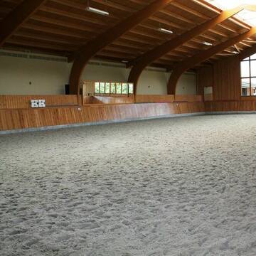
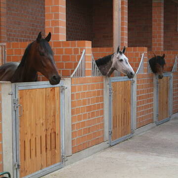
Wellenreiter Seeburg - Pensionsstall und mehr...
Seeburg
Wellenreiter-Seeburg
@Wellenreiter-Seeburg
Freizeitstall
Gastronomie
Hunde willkommen
Krankenbox
bedampftes/gewaschenes Heu
Hufrehe geeignet
Außenbox mit Paddock
Außenboxen
34 weitere...
S


Outback Corona
Willich/ Schiefbahn
Outback-Corona
@Outback-Corona
FN-Mitglied
Freizeitstall
Vermieten
Führanlage
Hunde willkommen
Allergikerstall
bedampftes/gewaschenes Heu
32 weitere...
S
Deprecated: Creation of dynamic property Zend_View_Helper_Ads::$adLink is deprecated in /var/www/stall-frei/htdocs/staging.stall-frei.de/library/Psf/View/Helper/Ads.php on line 108

Heu und Heulage verkaufen
Mechtersen
STALL-FREIde Marketing
@STALL-FREI-Marketing
Verkaufen Sie Ihr Heu und Ihre Heulage direkt an Reiter, Pferdeställe und Reitanlagen


Reiterhof Unterm Dün in Westhausen
Bodenrode-Westhausen
Reiterhof Riethmüller
@riethmueller-westhausen
Freizeitstall
Geländestrecke
Hunde willkommen
Paddock
Hengsthaltung möglich
Pferdezucht
Außenbox mit Paddock
Außenboxen
16 weitere...
P+
Pferde am Arkusberg
Beienrode
Franziska-Herbst
@Franziska-Herbst
Freizeitstall
Geländestrecke
Vermieten
Hunde willkommen
Krankenbox
Allergikerstall
Hufrehe geeignet
27 weitere...
P
Reitanlage Eichenhof
Krebeck
Gisbert-Hann
@Gisbert-Hann
Freizeitstall
Reitlehrer und -unterricht
Longierzirkel/Roundpen
Paddock
Außenbox mit Paddock
Außenboxen
Vollpension
10 weitere...
P+

Boxen und Offenstall frei
Gleichen
Unity-Fellponys
@Unity-Fellponys
Geländestrecke
Reitlehrer und -unterricht
Vermieten
Hunde willkommen
Paddock
Pferdezucht
16 weitere...
P

Heu aus neuer Ernte
Mechtersen
STALL-FREIde Marketing
@STALL-FREI-Marketing
Heulage und Pferdeheu aus der neuen Ernte findest du in unserem Futtermarkt


Reit- & Pensionsstall Wackelburg
Diemarden
Jan Pieper
@Laura92
Freizeitstall
Westernreiten
Vermieten
Hunde willkommen
Longierzirkel/Roundpen
Hufrehe geeignet
15 weitere...
P+
Hof Herbst = Pro Pferd
Gleichen Gelliehausen
Hof-Herbst=Pro-Pferd
@Hof-Herbst-Pro-Pferd
Freizeitstall
Reitlehrer und -unterricht
Vermieten
Krankenbox
Longierzirkel/Roundpen
Gnadenbrothof
16 weitere...
P

Reitanlage Klostergut Diemarden
Gleichen
Klostergut-Diemarden
@Klostergut-Diemarden
Freizeitstall
Reitlehrer und -unterricht
Vermieten
Longierzirkel/Roundpen
Paddock
Allergikerstall
Hufrehe geeignet
17 weitere...
P+
Leider kein Vorschaubild
Leider kein Vorschaubild
Offenstall bei Gö mit kleiner Halle und Reitplatz
Gleichen
Offenstall-Versteegen
@Offenstall-Versteegen
FN-Mitglied
Freizeitstall
Longierzirkel/Roundpen
Paddock
Fohlenaufzucht möglich
Hengsthaltung möglich
Offenstall
16 weitere...
B
Deprecated: Creation of dynamic property Zend_View::$pageCount is deprecated in /var/www/stall-frei/htdocs/staging.stall-frei.de/library/vendor/shardj/zf1-future/library/Zend/View/Abstract.php on line 308
Deprecated: Creation of dynamic property Zend_View::$itemCountPerPage is deprecated in /var/www/stall-frei/htdocs/staging.stall-frei.de/library/vendor/shardj/zf1-future/library/Zend/View/Abstract.php on line 308
Deprecated: Creation of dynamic property Zend_View::$first is deprecated in /var/www/stall-frei/htdocs/staging.stall-frei.de/library/vendor/shardj/zf1-future/library/Zend/View/Abstract.php on line 308
Deprecated: Creation of dynamic property Zend_View::$current is deprecated in /var/www/stall-frei/htdocs/staging.stall-frei.de/library/vendor/shardj/zf1-future/library/Zend/View/Abstract.php on line 308
Deprecated: Creation of dynamic property Zend_View::$last is deprecated in /var/www/stall-frei/htdocs/staging.stall-frei.de/library/vendor/shardj/zf1-future/library/Zend/View/Abstract.php on line 308
Deprecated: Creation of dynamic property Zend_View::$next is deprecated in /var/www/stall-frei/htdocs/staging.stall-frei.de/library/vendor/shardj/zf1-future/library/Zend/View/Abstract.php on line 308
Deprecated: Creation of dynamic property Zend_View::$pagesInRange is deprecated in /var/www/stall-frei/htdocs/staging.stall-frei.de/library/vendor/shardj/zf1-future/library/Zend/View/Abstract.php on line 308
Deprecated: Creation of dynamic property Zend_View::$firstPageInRange is deprecated in /var/www/stall-frei/htdocs/staging.stall-frei.de/library/vendor/shardj/zf1-future/library/Zend/View/Abstract.php on line 308
Deprecated: Creation of dynamic property Zend_View::$lastPageInRange is deprecated in /var/www/stall-frei/htdocs/staging.stall-frei.de/library/vendor/shardj/zf1-future/library/Zend/View/Abstract.php on line 308
Deprecated: Creation of dynamic property Zend_View::$currentItemCount is deprecated in /var/www/stall-frei/htdocs/staging.stall-frei.de/library/vendor/shardj/zf1-future/library/Zend/View/Abstract.php on line 308
Deprecated: Creation of dynamic property Zend_View::$totalItemCount is deprecated in /var/www/stall-frei/htdocs/staging.stall-frei.de/library/vendor/shardj/zf1-future/library/Zend/View/Abstract.php on line 308
Deprecated: Creation of dynamic property Zend_View::$firstItemNumber is deprecated in /var/www/stall-frei/htdocs/staging.stall-frei.de/library/vendor/shardj/zf1-future/library/Zend/View/Abstract.php on line 308
Deprecated: Creation of dynamic property Zend_View::$lastItemNumber is deprecated in /var/www/stall-frei/htdocs/staging.stall-frei.de/library/vendor/shardj/zf1-future/library/Zend/View/Abstract.php on line 308
Deprecated: Creation of dynamic property Zend_View::$router is deprecated in /var/www/stall-frei/htdocs/staging.stall-frei.de/library/vendor/shardj/zf1-future/library/Zend/View/Abstract.php on line 308
Deprecated: Creation of dynamic property Zend_View::$urlParams is deprecated in /var/www/stall-frei/htdocs/staging.stall-frei.de/library/vendor/shardj/zf1-future/library/Zend/View/Abstract.php on line 308
Deprecated: Creation of dynamic property Zend_View::$showAds is deprecated in /var/www/stall-frei/htdocs/staging.stall-frei.de/library/vendor/shardj/zf1-future/library/Zend/View/Abstract.php on line 308
Deprecated: Creation of dynamic property Zend_View::$objectIds is deprecated in /var/www/stall-frei/htdocs/staging.stall-frei.de/library/vendor/shardj/zf1-future/library/Zend/View/Abstract.php on line 308
Deprecated: Creation of dynamic property Zend_View::$showNavbar is deprecated in /var/www/stall-frei/htdocs/staging.stall-frei.de/library/vendor/shardj/zf1-future/library/Zend/View/Abstract.php on line 308
Deprecated: Creation of dynamic property Zend_View::$showBreadcrumb is deprecated in /var/www/stall-frei/htdocs/staging.stall-frei.de/library/vendor/shardj/zf1-future/library/Zend/View/Abstract.php on line 308
Deprecated: Creation of dynamic property Zend_View::$showFooter is deprecated in /var/www/stall-frei/htdocs/staging.stall-frei.de/library/vendor/shardj/zf1-future/library/Zend/View/Abstract.php on line 308
Deprecated: Creation of dynamic property Zend_View::$showInternalAds is deprecated in /var/www/stall-frei/htdocs/staging.stall-frei.de/library/vendor/shardj/zf1-future/library/Zend/View/Abstract.php on line 308
Deprecated: Creation of dynamic property Zend_View::$blNoContent is deprecated in /var/www/stall-frei/htdocs/staging.stall-frei.de/library/vendor/shardj/zf1-future/library/Zend/View/Abstract.php on line 308
Deprecated: Creation of dynamic property Zend_View::$sMetaDesc is deprecated in /var/www/stall-frei/htdocs/staging.stall-frei.de/library/vendor/shardj/zf1-future/library/Zend/View/Abstract.php on line 308
Deprecated: Creation of dynamic property Zend_View::$useGmaps is deprecated in /var/www/stall-frei/htdocs/staging.stall-frei.de/library/vendor/shardj/zf1-future/library/Zend/View/Abstract.php on line 308
Deprecated: Creation of dynamic property Zend_View::$touches is deprecated in /var/www/stall-frei/htdocs/staging.stall-frei.de/library/vendor/shardj/zf1-future/library/Zend/View/Abstract.php on line 308
Deprecated: Creation of dynamic property Zend_View::$oProject is deprecated in /var/www/stall-frei/htdocs/staging.stall-frei.de/library/vendor/shardj/zf1-future/library/Zend/View/Abstract.php on line 308
Deprecated: Creation of dynamic property Zend_View::$pageHeadline is deprecated in /var/www/stall-frei/htdocs/staging.stall-frei.de/library/vendor/shardj/zf1-future/library/Zend/View/Abstract.php on line 308
Deprecated: Creation of dynamic property Zend_View::$disableLocationField is deprecated in /var/www/stall-frei/htdocs/staging.stall-frei.de/library/vendor/shardj/zf1-future/library/Zend/View/Abstract.php on line 308
Deprecated: Creation of dynamic property Zend_View::$isSearch is deprecated in /var/www/stall-frei/htdocs/staging.stall-frei.de/library/vendor/shardj/zf1-future/library/Zend/View/Abstract.php on line 308
Deprecated: Creation of dynamic property Zend_View::$pageTitle is deprecated in /var/www/stall-frei/htdocs/staging.stall-frei.de/library/vendor/shardj/zf1-future/library/Zend/View/Abstract.php on line 308
Deprecated: Creation of dynamic property Psf_Form_Element_Text::$class is deprecated in /var/www/stall-frei/htdocs/staging.stall-frei.de/library/vendor/shardj/zf1-future/library/Zend/Form/Element.php on line 874
Deprecated: Creation of dynamic property Psf_Form_Element_Text::$size is deprecated in /var/www/stall-frei/htdocs/staging.stall-frei.de/library/vendor/shardj/zf1-future/library/Zend/Form/Element.php on line 874
Deprecated: Creation of dynamic property Psf_Form_Element_Text::$placeholder is deprecated in /var/www/stall-frei/htdocs/staging.stall-frei.de/library/vendor/shardj/zf1-future/library/Zend/Form/Element.php on line 874
Deprecated: Creation of dynamic property Psf_Form_Element_Hidden::$class is deprecated in /var/www/stall-frei/htdocs/staging.stall-frei.de/library/vendor/shardj/zf1-future/library/Zend/Form/Element.php on line 874
Deprecated: Creation of dynamic property Psf_Form_Element_Hidden::$class is deprecated in /var/www/stall-frei/htdocs/staging.stall-frei.de/library/vendor/shardj/zf1-future/library/Zend/Form/Element.php on line 874
Deprecated: Creation of dynamic property Psf_Form_Element_Hidden::$class is deprecated in /var/www/stall-frei/htdocs/staging.stall-frei.de/library/vendor/shardj/zf1-future/library/Zend/Form/Element.php on line 874
Deprecated: Creation of dynamic property Psf_Form_Element_Hidden::$class is deprecated in /var/www/stall-frei/htdocs/staging.stall-frei.de/library/vendor/shardj/zf1-future/library/Zend/Form/Element.php on line 874
Deprecated: Creation of dynamic property Psf_Form_Element_Select::$class is deprecated in /var/www/stall-frei/htdocs/staging.stall-frei.de/library/vendor/shardj/zf1-future/library/Zend/Form/Element.php on line 874
Deprecated: Creation of dynamic property Psf_Form_Element_Select::$class is deprecated in /var/www/stall-frei/htdocs/staging.stall-frei.de/library/vendor/shardj/zf1-future/library/Zend/Form/Element.php on line 874
Deprecated: Creation of dynamic property Psf_Form_Element_Select::$class is deprecated in /var/www/stall-frei/htdocs/staging.stall-frei.de/library/vendor/shardj/zf1-future/library/Zend/Form/Element.php on line 874
Deprecated: Creation of dynamic property Psf_Form_Element_Select::$class is deprecated in /var/www/stall-frei/htdocs/staging.stall-frei.de/library/vendor/shardj/zf1-future/library/Zend/Form/Element.php on line 874
Deprecated: Creation of dynamic property Psf_Form_Element_Text::$class is deprecated in /var/www/stall-frei/htdocs/staging.stall-frei.de/library/vendor/shardj/zf1-future/library/Zend/Form/Element.php on line 874
Deprecated: Creation of dynamic property Psf_Form_Element_Checkbox::$label is deprecated in /var/www/stall-frei/htdocs/staging.stall-frei.de/library/vendor/shardj/zf1-future/library/Zend/Form/Element.php on line 874
Deprecated: Creation of dynamic property Zend_View::$sort is deprecated in /var/www/stall-frei/htdocs/staging.stall-frei.de/library/vendor/shardj/zf1-future/library/Zend/View/Abstract.php on line 308
Deprecated: Creation of dynamic property Zend_View::$searchLocation is deprecated in /var/www/stall-frei/htdocs/staging.stall-frei.de/library/vendor/shardj/zf1-future/library/Zend/View/Abstract.php on line 308
Deprecated: Creation of dynamic property Zend_View::$locationHint is deprecated in /var/www/stall-frei/htdocs/staging.stall-frei.de/library/vendor/shardj/zf1-future/library/Zend/View/Abstract.php on line 308
Psf_GeoCoder_Abstract::getLocation: Hungerberg Get Location CachedOrLive
Psf_GeoCoder_Abstract::getCachedOrLive: Hungerberg
Psf_GeoCoder_OpenCageData::makeApiRequest: response:
Array
(
[documentation] => https://opencagedata.com/api
[licenses] => Array
(
[0] => Array
(
[name] => see attribution guide
[url] => https://opencagedata.com/credits
)
)
[results] => Array
(
[0] => Array
(
[bounds] => Array
(
[northeast] => Array
(
[lat] => 51.4603051
[lng] => 10.2146622
)
[southwest] => Array
(
[lat] => 51.4602051
[lng] => 10.2145622
)
)
[components] => Array
(
[ISO_3166-1_alpha-2] => DE
[ISO_3166-1_alpha-3] => DEU
[ISO_3166-2] => Array
(
[0] => DE-TH
)
[_category] => natural/water
[_normalized_city] => Teistungen
[_type] => peak
[continent] => Europe
[country] => Deutschland
[country_code] => de
[county] => Landkreis Eichsfeld
[municipality] => Lindenberg/Eichsfeld
[peak] => Hungerberg
[political_union] => European Union
[state] => Thüringen
[state_code] => TH
[village] => Teistungen
)
[confidence] => 9
[formatted] => Hungerberg, Teistungen, Thüringen, Deutschland
[geometry] => Array
(
[lat] => 51.4602551
[lng] => 10.2146122
)
)
[1] => Array
(
[bounds] => Array
(
[northeast] => Array
(
[lat] => 49.777615
[lng] => 6.5694126
)
[southwest] => Array
(
[lat] => 49.777515
[lng] => 6.5693126
)
)
[components] => Array
(
[ISO_3166-1_alpha-2] => DE
[ISO_3166-1_alpha-3] => DEU
[ISO_3166-2] => Array
(
[0] => DE-RP
)
[_category] => natural/water
[_normalized_city] => Trierweiler
[_type] => peak
[continent] => Europe
[country] => Deutschland
[country_code] => de
[county] => Landkreis Trier-Saarburg
[municipality] => Trier-Land
[peak] => Hungerberg
[political_union] => European Union
[postcode] => 54298
[state] => Rheinland-Pfalz
[state_code] => RP
[village] => Trierweiler
)
[confidence] => 9
[formatted] => Hungerberg, 54298 Trierweiler, Deutschland
[geometry] => Array
(
[lat] => 49.777565
[lng] => 6.5693626
)
)
[2] => Array
(
[bounds] => Array
(
[northeast] => Array
(
[lat] => 50.0502642
[lng] => 9.8540626
)
[southwest] => Array
(
[lat] => 50.0501642
[lng] => 9.8539626
)
)
[components] => Array
(
[ISO_3166-1_alpha-2] => DE
[ISO_3166-1_alpha-3] => DEU
[ISO_3166-2] => Array
(
[0] => DE-BY
)
[_category] => natural/water
[_normalized_city] => Hammelburg
[_type] => peak
[continent] => Europe
[country] => Deutschland
[country_code] => de
[county] => Landkreis Bad Kissingen
[peak] => Hungerberg
[political_union] => European Union
[state] => Bayern
[state_code] => BY
[town] => Hammelburg
)
[confidence] => 9
[formatted] => Hungerberg, Hammelburg, Bayern, Deutschland
[geometry] => Array
(
[lat] => 50.0502142
[lng] => 9.8540126
)
)
[3] => Array
(
[bounds] => Array
(
[northeast] => Array
(
[lat] => 48.6518404
[lng] => 10.2703251
)
[southwest] => Array
(
[lat] => 48.6517404
[lng] => 10.2702251
)
)
[components] => Array
(
[ISO_3166-1_alpha-2] => DE
[ISO_3166-1_alpha-3] => DEU
[ISO_3166-2] => Array
(
[0] => DE-BY
)
[_category] => natural/water
[_normalized_city] => Syrgenstein
[_type] => peak
[continent] => Europe
[country] => Deutschland
[country_code] => de
[county] => Landkreis Dillingen an der Donau
[municipality] => Syrgenstein
[peak] => Hungerberg
[political_union] => European Union
[postcode] => 89428
[state] => Bayern
[state_code] => BY
)
[confidence] => 9
[formatted] => Hungerberg, 89428 Syrgenstein, Deutschland
[geometry] => Array
(
[lat] => 48.6517904
[lng] => 10.2702751
)
)
[4] => Array
(
[bounds] => Array
(
[northeast] => Array
(
[lat] => 50.026625
[lng] => 6.348148
)
[southwest] => Array
(
[lat] => 50.026525
[lng] => 6.348048
)
)
[components] => Array
(
[ISO_3166-1_alpha-2] => DE
[ISO_3166-1_alpha-3] => DEU
[ISO_3166-2] => Array
(
[0] => DE-RP
)
[_category] => natural/water
[_normalized_city] => Fischbach-Oberraden
[_type] => peak
[continent] => Europe
[country] => Deutschland
[country_code] => de
[county] => Eifelkreis Bitburg-Prüm
[municipality] => Südeifel
[peak] => Hungerberg
[political_union] => European Union
[state] => Rheinland-Pfalz
[state_code] => RP
[village] => Fischbach-Oberraden
)
[confidence] => 9
[formatted] => Hungerberg, Fischbach-Oberraden, Rheinland-Pfalz, Deutschland
[geometry] => Array
(
[lat] => 50.026575
[lng] => 6.348098
)
)
[5] => Array
(
[bounds] => Array
(
[northeast] => Array
(
[lat] => 48.1753691
[lng] => 9.5699466
)
[southwest] => Array
(
[lat] => 48.1752691
[lng] => 9.5698466
)
)
[components] => Array
(
[ISO_3166-1_alpha-2] => DE
[ISO_3166-1_alpha-3] => DEU
[ISO_3166-2] => Array
(
[0] => DE-BW
)
[_category] => natural/water
[_normalized_city] => Unlingen
[_type] => peak
[continent] => Europe
[country] => Deutschland
[country_code] => de
[county] => Landkreis Biberach
[municipality] => VVG der Stadt Riedlingen
[peak] => Hungerberg
[political_union] => European Union
[postcode] => 88524
[state] => Baden-Württemberg
[state_code] => BW
[village] => Unlingen
)
[confidence] => 9
[formatted] => Hungerberg, 88524 Unlingen, Deutschland
[geometry] => Array
(
[lat] => 48.1753191
[lng] => 9.5698966
)
)
[6] => Array
(
[bounds] => Array
(
[northeast] => Array
(
[lat] => 48.052703
[lng] => 9.4230079
)
[southwest] => Array
(
[lat] => 48.052603
[lng] => 9.4229079
)
)
[components] => Array
(
[ISO_3166-1_alpha-2] => DE
[ISO_3166-1_alpha-3] => DEU
[ISO_3166-2] => Array
(
[0] => DE-BW
)
[_category] => natural/water
[_normalized_city] => Herbertingen
[_type] => peak
[continent] => Europe
[country] => Deutschland
[country_code] => de
[county] => Landkreis Sigmaringen
[municipality] => VVG der Stadt Bad Saulgau
[peak] => Hungerberg
[political_union] => European Union
[postcode] => 88518
[state] => Baden-Württemberg
[state_code] => BW
[village] => Herbertingen
)
[confidence] => 9
[formatted] => Hungerberg, 88518 Herbertingen, Deutschland
[geometry] => Array
(
[lat] => 48.052653
[lng] => 9.4229579
)
)
[7] => Array
(
[bounds] => Array
(
[northeast] => Array
(
[lat] => 47.8090367
[lng] => 10.5980868
)
[southwest] => Array
(
[lat] => 47.8089367
[lng] => 10.5979868
)
)
[components] => Array
(
[ISO_3166-1_alpha-2] => DE
[ISO_3166-1_alpha-3] => DEU
[ISO_3166-2] => Array
(
[0] => DE-BY
)
[_category] => natural/water
[_normalized_city] => Ruderatshofen
[_type] => peak
[continent] => Europe
[country] => Deutschland
[country_code] => de
[county] => Landkreis Ostallgäu
[municipality] => Biessenhofen (VGem)
[peak] => Hungerberg
[political_union] => European Union
[postcode] => 87674
[state] => Bayern
[state_code] => BY
[village] => Ruderatshofen
)
[confidence] => 9
[formatted] => Hungerberg, 87674 Ruderatshofen, Deutschland
[geometry] => Array
(
[lat] => 47.8089867
[lng] => 10.5980368
)
)
[8] => Array
(
[bounds] => Array
(
[northeast] => Array
(
[lat] => 49.4621708
[lng] => 6.733719
)
[southwest] => Array
(
[lat] => 49.4620708
[lng] => 6.733619
)
)
[components] => Array
(
[ISO_3166-1_alpha-2] => DE
[ISO_3166-1_alpha-3] => DEU
[ISO_3166-2] => Array
(
[0] => DE-SL
)
[_category] => natural/water
[_normalized_city] => Beckingen
[_type] => peak
[continent] => Europe
[country] => Deutschland
[country_code] => de
[county] => Landkreis Merzig-Wadern
[peak] => Hungerberg
[political_union] => European Union
[postcode] => 66679
[state] => Saarland
[state_code] => SL
[town] => Beckingen
)
[confidence] => 9
[formatted] => Hungerberg, 66679 Beckingen, Deutschland
[geometry] => Array
(
[lat] => 49.4621208
[lng] => 6.733669
)
)
[9] => Array
(
[components] => Array
(
[ISO_3166-1_alpha-2] => FR
[ISO_3166-1_alpha-3] => FRA
[ISO_3166-2] => Array
(
[0] => FR-GES
[1] => FR-6AE
[2] => FR-67
)
[_category] => road
[_normalized_city] => Mietesheim
[_type] => road
[city] => Mietesheim
[continent] => Europe
[country] => France
[country_code] => fr
[county] => Bas-Rhin
[local_authority] => Communauté de communes du Pays de Niederbronn-les-Bains
[political_union] => European Union
[postcode] => 67580
[road] => Hungerberg
[state] => Grand Est
[state_code] => GES
)
[confidence] => 4
[formatted] => Hungerberg, 67580 Mietesheim, France
[geometry] => Array
(
[lat] => 48.889583
[lng] => 7.637659
)
)
)
[status] => Array
(
[code] => 200
[message] => OK
)
[stay_informed] => Array
(
[blog] => https://blog.opencagedata.com
[mastodon] => https://en.osm.town/@opencage
)
[thanks] => For using an OpenCage API
[timestamp] => Array
(
[created_http] => Sun, 08 Feb 2026 19:35:20 GMT
[created_unix] => 1770579320
)
[total_results] => 10
)
Psf_GeoCoder_Abstract::convertLocationResult
{"documentation":"https:\/\/opencagedata.com\/api","licenses":[{"name":"see attribution guide","url":"https:\/\/opencagedata.com\/credits"}],"results":[{"bounds":{"northeast":{"lat":51.4603051,"lng":10.2146622},"southwest":{"lat":51.4602051,"lng":10.2145622}},"components":{"ISO_3166-1_alpha-2":"DE","ISO_3166-1_alpha-3":"DEU","ISO_3166-2":["DE-TH"],"_category":"natural\/water","_normalized_city":"Teistungen","_type":"peak","continent":"Europe","country":"Deutschland","country_code":"de","county":"Landkreis Eichsfeld","municipality":"Lindenberg\/Eichsfeld","peak":"Hungerberg","political_union":"European Union","state":"Th\u00fcringen","state_code":"TH","village":"Teistungen"},"confidence":9,"formatted":"Hungerberg, Teistungen, Th\u00fcringen, Deutschland","geometry":{"lat":51.4602551,"lng":10.2146122}},{"bounds":{"northeast":{"lat":49.777615,"lng":6.5694126},"southwest":{"lat":49.777515,"lng":6.5693126}},"components":{"ISO_3166-1_alpha-2":"DE","ISO_3166-1_alpha-3":"DEU","ISO_3166-2":["DE-RP"],"_category":"natural\/water","_normalized_city":"Trierweiler","_type":"peak","continent":"Europe","country":"Deutschland","country_code":"de","county":"Landkreis Trier-Saarburg","municipality":"Trier-Land","peak":"Hungerberg","political_union":"European Union","postcode":"54298","state":"Rheinland-Pfalz","state_code":"RP","village":"Trierweiler"},"confidence":9,"formatted":"Hungerberg, 54298 Trierweiler, Deutschland","geometry":{"lat":49.777565,"lng":6.5693626}},{"bounds":{"northeast":{"lat":50.0502642,"lng":9.8540626},"southwest":{"lat":50.0501642,"lng":9.8539626}},"components":{"ISO_3166-1_alpha-2":"DE","ISO_3166-1_alpha-3":"DEU","ISO_3166-2":["DE-BY"],"_category":"natural\/water","_normalized_city":"Hammelburg","_type":"peak","continent":"Europe","country":"Deutschland","country_code":"de","county":"Landkreis Bad Kissingen","peak":"Hungerberg","political_union":"European Union","state":"Bayern","state_code":"BY","town":"Hammelburg"},"confidence":9,"formatted":"Hungerberg, Hammelburg, Bayern, Deutschland","geometry":{"lat":50.0502142,"lng":9.8540126}},{"bounds":{"northeast":{"lat":48.6518404,"lng":10.2703251},"southwest":{"lat":48.6517404,"lng":10.2702251}},"components":{"ISO_3166-1_alpha-2":"DE","ISO_3166-1_alpha-3":"DEU","ISO_3166-2":["DE-BY"],"_category":"natural\/water","_normalized_city":"Syrgenstein","_type":"peak","continent":"Europe","country":"Deutschland","country_code":"de","county":"Landkreis Dillingen an der Donau","municipality":"Syrgenstein","peak":"Hungerberg","political_union":"European Union","postcode":"89428","state":"Bayern","state_code":"BY"},"confidence":9,"formatted":"Hungerberg, 89428 Syrgenstein, Deutschland","geometry":{"lat":48.6517904,"lng":10.2702751}},{"bounds":{"northeast":{"lat":50.026625,"lng":6.348148},"southwest":{"lat":50.026525,"lng":6.348048}},"components":{"ISO_3166-1_alpha-2":"DE","ISO_3166-1_alpha-3":"DEU","ISO_3166-2":["DE-RP"],"_category":"natural\/water","_normalized_city":"Fischbach-Oberraden","_type":"peak","continent":"Europe","country":"Deutschland","country_code":"de","county":"Eifelkreis Bitburg-Pr\u00fcm","municipality":"S\u00fcdeifel","peak":"Hungerberg","political_union":"European Union","state":"Rheinland-Pfalz","state_code":"RP","village":"Fischbach-Oberraden"},"confidence":9,"formatted":"Hungerberg, Fischbach-Oberraden, Rheinland-Pfalz, Deutschland","geometry":{"lat":50.026575,"lng":6.348098}},{"bounds":{"northeast":{"lat":48.1753691,"lng":9.5699466},"southwest":{"lat":48.1752691,"lng":9.5698466}},"components":{"ISO_3166-1_alpha-2":"DE","ISO_3166-1_alpha-3":"DEU","ISO_3166-2":["DE-BW"],"_category":"natural\/water","_normalized_city":"Unlingen","_type":"peak","continent":"Europe","country":"Deutschland","country_code":"de","county":"Landkreis Biberach","municipality":"VVG der Stadt Riedlingen","peak":"Hungerberg","political_union":"European Union","postcode":"88524","state":"Baden-W\u00fcrttemberg","state_code":"BW","village":"Unlingen"},"confidence":9,"formatted":"Hungerberg, 88524 Unlingen, Deutschland","geometry":{"lat":48.1753191,"lng":9.5698966}},{"bounds":{"northeast":{"lat":48.052703,"lng":9.4230079},"southwest":{"lat":48.052603,"lng":9.4229079}},"components":{"ISO_3166-1_alpha-2":"DE","ISO_3166-1_alpha-3":"DEU","ISO_3166-2":["DE-BW"],"_category":"natural\/water","_normalized_city":"Herbertingen","_type":"peak","continent":"Europe","country":"Deutschland","country_code":"de","county":"Landkreis Sigmaringen","municipality":"VVG der Stadt Bad Saulgau","peak":"Hungerberg","political_union":"European Union","postcode":"88518","state":"Baden-W\u00fcrttemberg","state_code":"BW","village":"Herbertingen"},"confidence":9,"formatted":"Hungerberg, 88518 Herbertingen, Deutschland","geometry":{"lat":48.052653,"lng":9.4229579}},{"bounds":{"northeast":{"lat":47.8090367,"lng":10.5980868},"southwest":{"lat":47.8089367,"lng":10.5979868}},"components":{"ISO_3166-1_alpha-2":"DE","ISO_3166-1_alpha-3":"DEU","ISO_3166-2":["DE-BY"],"_category":"natural\/water","_normalized_city":"Ruderatshofen","_type":"peak","continent":"Europe","country":"Deutschland","country_code":"de","county":"Landkreis Ostallg\u00e4u","municipality":"Biessenhofen (VGem)","peak":"Hungerberg","political_union":"European Union","postcode":"87674","state":"Bayern","state_code":"BY","village":"Ruderatshofen"},"confidence":9,"formatted":"Hungerberg, 87674 Ruderatshofen, Deutschland","geometry":{"lat":47.8089867,"lng":10.5980368}},{"bounds":{"northeast":{"lat":49.4621708,"lng":6.733719},"southwest":{"lat":49.4620708,"lng":6.733619}},"components":{"ISO_3166-1_alpha-2":"DE","ISO_3166-1_alpha-3":"DEU","ISO_3166-2":["DE-SL"],"_category":"natural\/water","_normalized_city":"Beckingen","_type":"peak","continent":"Europe","country":"Deutschland","country_code":"de","county":"Landkreis Merzig-Wadern","peak":"Hungerberg","political_union":"European Union","postcode":"66679","state":"Saarland","state_code":"SL","town":"Beckingen"},"confidence":9,"formatted":"Hungerberg, 66679 Beckingen, Deutschland","geometry":{"lat":49.4621208,"lng":6.733669}},{"components":{"ISO_3166-1_alpha-2":"FR","ISO_3166-1_alpha-3":"FRA","ISO_3166-2":["FR-GES","FR-6AE","FR-67"],"_category":"road","_normalized_city":"Mietesheim","_type":"road","city":"Mietesheim","continent":"Europe","country":"France","country_code":"fr","county":"Bas-Rhin","local_authority":"Communaut\u00e9 de communes du Pays de Niederbronn-les-Bains","political_union":"European Union","postcode":"67580","road":"Hungerberg","state":"Grand Est","state_code":"GES"},"confidence":4,"formatted":"Hungerberg, 67580 Mietesheim, France","geometry":{"lat":48.889583,"lng":7.637659}}],"status":{"code":200,"message":"OK"},"stay_informed":{"blog":"https:\/\/blog.opencagedata.com","mastodon":"https:\/\/en.osm.town\/@opencage"},"thanks":"For using an OpenCage API","timestamp":{"created_http":"Sun, 08 Feb 2026 19:35:20 GMT","created_unix":1770579320},"total_results":10}Array
(
[0] => stdClass Object
(
[bounds] => stdClass Object
(
[northeast] => stdClass Object
(
[lat] => 51.4603051
[lng] => 10.2146622
)
[southwest] => stdClass Object
(
[lat] => 51.4602051
[lng] => 10.2145622
)
)
[components] => stdClass Object
(
[ISO_3166-1_alpha-2] => DE
[ISO_3166-1_alpha-3] => DEU
[ISO_3166-2] => Array
(
[0] => DE-TH
)
[_category] => natural/water
[_normalized_city] => Teistungen
[_type] => peak
[continent] => Europe
[country] => Deutschland
[country_code] => de
[county] => Landkreis Eichsfeld
[municipality] => Lindenberg/Eichsfeld
[peak] => Hungerberg
[political_union] => European Union
[state] => Thüringen
[state_code] => TH
[village] => Teistungen
)
[confidence] => 9
[formatted] => Hungerberg, Teistungen, Thüringen, Deutschland
[geometry] => stdClass Object
(
[lat] => 51.4602551
[lng] => 10.2146122
)
)
[1] => stdClass Object
(
[bounds] => stdClass Object
(
[northeast] => stdClass Object
(
[lat] => 49.777615
[lng] => 6.5694126
)
[southwest] => stdClass Object
(
[lat] => 49.777515
[lng] => 6.5693126
)
)
[components] => stdClass Object
(
[ISO_3166-1_alpha-2] => DE
[ISO_3166-1_alpha-3] => DEU
[ISO_3166-2] => Array
(
[0] => DE-RP
)
[_category] => natural/water
[_normalized_city] => Trierweiler
[_type] => peak
[continent] => Europe
[country] => Deutschland
[country_code] => de
[county] => Landkreis Trier-Saarburg
[municipality] => Trier-Land
[peak] => Hungerberg
[political_union] => European Union
[postcode] => 54298
[state] => Rheinland-Pfalz
[state_code] => RP
[village] => Trierweiler
)
[confidence] => 9
[formatted] => Hungerberg, 54298 Trierweiler, Deutschland
[geometry] => stdClass Object
(
[lat] => 49.777565
[lng] => 6.5693626
)
)
[2] => stdClass Object
(
[bounds] => stdClass Object
(
[northeast] => stdClass Object
(
[lat] => 50.0502642
[lng] => 9.8540626
)
[southwest] => stdClass Object
(
[lat] => 50.0501642
[lng] => 9.8539626
)
)
[components] => stdClass Object
(
[ISO_3166-1_alpha-2] => DE
[ISO_3166-1_alpha-3] => DEU
[ISO_3166-2] => Array
(
[0] => DE-BY
)
[_category] => natural/water
[_normalized_city] => Hammelburg
[_type] => peak
[continent] => Europe
[country] => Deutschland
[country_code] => de
[county] => Landkreis Bad Kissingen
[peak] => Hungerberg
[political_union] => European Union
[state] => Bayern
[state_code] => BY
[town] => Hammelburg
)
[confidence] => 9
[formatted] => Hungerberg, Hammelburg, Bayern, Deutschland
[geometry] => stdClass Object
(
[lat] => 50.0502142
[lng] => 9.8540126
)
)
[3] => stdClass Object
(
[bounds] => stdClass Object
(
[northeast] => stdClass Object
(
[lat] => 48.6518404
[lng] => 10.2703251
)
[southwest] => stdClass Object
(
[lat] => 48.6517404
[lng] => 10.2702251
)
)
[components] => stdClass Object
(
[ISO_3166-1_alpha-2] => DE
[ISO_3166-1_alpha-3] => DEU
[ISO_3166-2] => Array
(
[0] => DE-BY
)
[_category] => natural/water
[_normalized_city] => Syrgenstein
[_type] => peak
[continent] => Europe
[country] => Deutschland
[country_code] => de
[county] => Landkreis Dillingen an der Donau
[municipality] => Syrgenstein
[peak] => Hungerberg
[political_union] => European Union
[postcode] => 89428
[state] => Bayern
[state_code] => BY
)
[confidence] => 9
[formatted] => Hungerberg, 89428 Syrgenstein, Deutschland
[geometry] => stdClass Object
(
[lat] => 48.6517904
[lng] => 10.2702751
)
)
[4] => stdClass Object
(
[bounds] => stdClass Object
(
[northeast] => stdClass Object
(
[lat] => 50.026625
[lng] => 6.348148
)
[southwest] => stdClass Object
(
[lat] => 50.026525
[lng] => 6.348048
)
)
[components] => stdClass Object
(
[ISO_3166-1_alpha-2] => DE
[ISO_3166-1_alpha-3] => DEU
[ISO_3166-2] => Array
(
[0] => DE-RP
)
[_category] => natural/water
[_normalized_city] => Fischbach-Oberraden
[_type] => peak
[continent] => Europe
[country] => Deutschland
[country_code] => de
[county] => Eifelkreis Bitburg-Prüm
[municipality] => Südeifel
[peak] => Hungerberg
[political_union] => European Union
[state] => Rheinland-Pfalz
[state_code] => RP
[village] => Fischbach-Oberraden
)
[confidence] => 9
[formatted] => Hungerberg, Fischbach-Oberraden, Rheinland-Pfalz, Deutschland
[geometry] => stdClass Object
(
[lat] => 50.026575
[lng] => 6.348098
)
)
[5] => stdClass Object
(
[bounds] => stdClass Object
(
[northeast] => stdClass Object
(
[lat] => 48.1753691
[lng] => 9.5699466
)
[southwest] => stdClass Object
(
[lat] => 48.1752691
[lng] => 9.5698466
)
)
[components] => stdClass Object
(
[ISO_3166-1_alpha-2] => DE
[ISO_3166-1_alpha-3] => DEU
[ISO_3166-2] => Array
(
[0] => DE-BW
)
[_category] => natural/water
[_normalized_city] => Unlingen
[_type] => peak
[continent] => Europe
[country] => Deutschland
[country_code] => de
[county] => Landkreis Biberach
[municipality] => VVG der Stadt Riedlingen
[peak] => Hungerberg
[political_union] => European Union
[postcode] => 88524
[state] => Baden-Württemberg
[state_code] => BW
[village] => Unlingen
)
[confidence] => 9
[formatted] => Hungerberg, 88524 Unlingen, Deutschland
[geometry] => stdClass Object
(
[lat] => 48.1753191
[lng] => 9.5698966
)
)
[6] => stdClass Object
(
[bounds] => stdClass Object
(
[northeast] => stdClass Object
(
[lat] => 48.052703
[lng] => 9.4230079
)
[southwest] => stdClass Object
(
[lat] => 48.052603
[lng] => 9.4229079
)
)
[components] => stdClass Object
(
[ISO_3166-1_alpha-2] => DE
[ISO_3166-1_alpha-3] => DEU
[ISO_3166-2] => Array
(
[0] => DE-BW
)
[_category] => natural/water
[_normalized_city] => Herbertingen
[_type] => peak
[continent] => Europe
[country] => Deutschland
[country_code] => de
[county] => Landkreis Sigmaringen
[municipality] => VVG der Stadt Bad Saulgau
[peak] => Hungerberg
[political_union] => European Union
[postcode] => 88518
[state] => Baden-Württemberg
[state_code] => BW
[village] => Herbertingen
)
[confidence] => 9
[formatted] => Hungerberg, 88518 Herbertingen, Deutschland
[geometry] => stdClass Object
(
[lat] => 48.052653
[lng] => 9.4229579
)
)
[7] => stdClass Object
(
[bounds] => stdClass Object
(
[northeast] => stdClass Object
(
[lat] => 47.8090367
[lng] => 10.5980868
)
[southwest] => stdClass Object
(
[lat] => 47.8089367
[lng] => 10.5979868
)
)
[components] => stdClass Object
(
[ISO_3166-1_alpha-2] => DE
[ISO_3166-1_alpha-3] => DEU
[ISO_3166-2] => Array
(
[0] => DE-BY
)
[_category] => natural/water
[_normalized_city] => Ruderatshofen
[_type] => peak
[continent] => Europe
[country] => Deutschland
[country_code] => de
[county] => Landkreis Ostallgäu
[municipality] => Biessenhofen (VGem)
[peak] => Hungerberg
[political_union] => European Union
[postcode] => 87674
[state] => Bayern
[state_code] => BY
[village] => Ruderatshofen
)
[confidence] => 9
[formatted] => Hungerberg, 87674 Ruderatshofen, Deutschland
[geometry] => stdClass Object
(
[lat] => 47.8089867
[lng] => 10.5980368
)
)
[8] => stdClass Object
(
[bounds] => stdClass Object
(
[northeast] => stdClass Object
(
[lat] => 49.4621708
[lng] => 6.733719
)
[southwest] => stdClass Object
(
[lat] => 49.4620708
[lng] => 6.733619
)
)
[components] => stdClass Object
(
[ISO_3166-1_alpha-2] => DE
[ISO_3166-1_alpha-3] => DEU
[ISO_3166-2] => Array
(
[0] => DE-SL
)
[_category] => natural/water
[_normalized_city] => Beckingen
[_type] => peak
[continent] => Europe
[country] => Deutschland
[country_code] => de
[county] => Landkreis Merzig-Wadern
[peak] => Hungerberg
[political_union] => European Union
[postcode] => 66679
[state] => Saarland
[state_code] => SL
[town] => Beckingen
)
[confidence] => 9
[formatted] => Hungerberg, 66679 Beckingen, Deutschland
[geometry] => stdClass Object
(
[lat] => 49.4621208
[lng] => 6.733669
)
)
[9] => stdClass Object
(
[components] => stdClass Object
(
[ISO_3166-1_alpha-2] => FR
[ISO_3166-1_alpha-3] => FRA
[ISO_3166-2] => Array
(
[0] => FR-GES
[1] => FR-6AE
[2] => FR-67
)
[_category] => road
[_normalized_city] => Mietesheim
[_type] => road
[city] => Mietesheim
[continent] => Europe
[country] => France
[country_code] => fr
[county] => Bas-Rhin
[local_authority] => Communauté de communes du Pays de Niederbronn-les-Bains
[political_union] => European Union
[postcode] => 67580
[road] => Hungerberg
[state] => Grand Est
[state_code] => GES
)
[confidence] => 4
[formatted] => Hungerberg, 67580 Mietesheim, France
[geometry] => stdClass Object
(
[lat] => 48.889583
[lng] => 7.637659
)
)
)
Psf_GeoCoder_OpenCageData::getKeyMap: 0
stdClass Object
(
    [bounds] => stdClass Object
        (
            [northeast] => stdClass Object
                (
                    [lat] => 51.4603051
                    [lng] => 10.2146622
                )

            [southwest] => stdClass Object
                (
                    [lat] => 51.4602051
                    [lng] => 10.2145622
                )

        )

    [components] => stdClass Object
        (
            [ISO_3166-1_alpha-2] => DE
            [ISO_3166-1_alpha-3] => DEU
            [ISO_3166-2] => Array
                (
                    [0] => DE-TH
                )

            [_category] => natural/water
            [_normalized_city] => Teistungen
            [_type] => peak
            [continent] => Europe
            [country] => Deutschland
            [country_code] => de
            [county] => Landkreis Eichsfeld
            [municipality] => Lindenberg/Eichsfeld
            [peak] => Hungerberg
            [political_union] => European Union
            [state] => Thüringen
            [state_code] => TH
            [village] => Teistungen
        )

    [confidence] => 9
    [formatted] => Hungerberg, Teistungen, Thüringen, Deutschland
    [geometry] => stdClass Object
        (
            [lat] => 51.4602551
            [lng] => 10.2146122
        )

)
Psf_GeoCoder_OpenCageData::getCounty: Eichsfeld
Psf_GeoCoder_OpenCageData::addMissingData REFETCH!
Array
(
    [address] => Hungerberg, Teistungen, Thüringen, Deutschland
    [type] => peak
    [street] =>
    [city] => Teistungen
    [county] => Eichsfeld
    [state] => Thüringen
    [zip] =>
    [country] => Deutschland
    [suburb] =>
    [countrycode] => de
    [latitude] => 51.4602551
    [longitude] => 10.2146122
    [accuracy] => 1
    [confidence] => 9
    [bounds] => stdClass Object
        (
            [northeast] => stdClass Object
                (
                    [lat] => 51.4603051
                    [lng] => 10.2146622
                )

            [southwest] => stdClass Object
                (
                    [lat] => 51.4602051
                    [lng] => 10.2145622
                )

        )

)
reformat!
Array
(
    [address] => Hungerberg, Teistungen, Thüringen, Deutschland
    [type] => peak
    [street] =>
    [city] => Teistungen
    [county] => Eichsfeld
    [state] => Thüringen
    [zip] =>
    [country] => Deutschland
    [suburb] =>
    [countrycode] => de
    [latitude] => 51.4602551
    [longitude] => 10.2146122
    [accuracy] => 1
    [confidence] => 9
    [bounds] => stdClass Object
        (
            [northeast] => stdClass Object
                (
                    [lat] => 51.4603051
                    [lng] => 10.2146622
                )

            [southwest] => stdClass Object
                (
                    [lat] => 51.4602051
                    [lng] => 10.2145622
                )

        )

    [place] => Teistungen, Thüringen
    [hash] => 748da61cdf106f1d12bf2529a6f09c56
)
Psf_GeoCoder_OpenCageData::getKeyMap: 1
stdClass Object
(
    [bounds] => stdClass Object
        (
            [northeast] => stdClass Object
                (
                    [lat] => 49.777615
                    [lng] => 6.5694126
                )

            [southwest] => stdClass Object
                (
                    [lat] => 49.777515
                    [lng] => 6.5693126
                )

        )

    [components] => stdClass Object
        (
            [ISO_3166-1_alpha-2] => DE
            [ISO_3166-1_alpha-3] => DEU
            [ISO_3166-2] => Array
                (
                    [0] => DE-RP
                )

            [_category] => natural/water
            [_normalized_city] => Trierweiler
            [_type] => peak
            [continent] => Europe
            [country] => Deutschland
            [country_code] => de
            [county] => Landkreis Trier-Saarburg
            [municipality] => Trier-Land
            [peak] => Hungerberg
            [political_union] => European Union
            [postcode] => 54298
            [state] => Rheinland-Pfalz
            [state_code] => RP
            [village] => Trierweiler
        )

    [confidence] => 9
    [formatted] => Hungerberg, 54298 Trierweiler, Deutschland
    [geometry] => stdClass Object
        (
            [lat] => 49.777565
            [lng] => 6.5693626
        )

)
Psf_GeoCoder_OpenCageData::getCounty: Trier-Saarburg
Psf_GeoCoder_OpenCageData::addMissingData REFETCH!
Array
(
    [address] => Hungerberg, 54298 Trierweiler, Deutschland
    [type] => peak
    [street] =>
    [city] => Trierweiler
    [county] => Trier-Saarburg
    [state] => Rheinland-Pfalz
    [zip] => 54298
    [country] => Deutschland
    [suburb] =>
    [countrycode] => de
    [latitude] => 49.777565
    [longitude] => 6.5693626
    [accuracy] => 1
    [confidence] => 9
    [bounds] => stdClass Object
        (
            [northeast] => stdClass Object
                (
                    [lat] => 49.777615
                    [lng] => 6.5694126
                )

            [southwest] => stdClass Object
                (
                    [lat] => 49.777515
                    [lng] => 6.5693126
                )

        )

)
reformat!
Array
(
    [address] => Hungerberg, 54298 Trierweiler, Deutschland
    [type] => peak
    [street] =>
    [city] => Trierweiler
    [county] => Trier-Saarburg
    [state] => Rheinland-Pfalz
    [zip] => 54298
    [country] => Deutschland
    [suburb] =>
    [countrycode] => de
    [latitude] => 49.777565
    [longitude] => 6.5693626
    [accuracy] => 1
    [confidence] => 9
    [bounds] => stdClass Object
        (
            [northeast] => stdClass Object
                (
                    [lat] => 49.777615
                    [lng] => 6.5694126
                )

            [southwest] => stdClass Object
                (
                    [lat] => 49.777515
                    [lng] => 6.5693126
                )

        )

    [place] => 54298 Trierweiler, Rheinland-Pfalz
    [hash] => c1a04488f64265a5cb07be380563838b
)
Psf_GeoCoder_OpenCageData::getKeyMap: 2
stdClass Object
(
    [bounds] => stdClass Object
        (
            [northeast] => stdClass Object
                (
                    [lat] => 50.0502642
                    [lng] => 9.8540626
                )

            [southwest] => stdClass Object
                (
                    [lat] => 50.0501642
                    [lng] => 9.8539626
                )

        )

    [components] => stdClass Object
        (
            [ISO_3166-1_alpha-2] => DE
            [ISO_3166-1_alpha-3] => DEU
            [ISO_3166-2] => Array
                (
                    [0] => DE-BY
                )

            [_category] => natural/water
            [_normalized_city] => Hammelburg
            [_type] => peak
            [continent] => Europe
            [country] => Deutschland
            [country_code] => de
            [county] => Landkreis Bad Kissingen
            [peak] => Hungerberg
            [political_union] => European Union
            [state] => Bayern
            [state_code] => BY
            [town] => Hammelburg
        )

    [confidence] => 9
    [formatted] => Hungerberg, Hammelburg, Bayern, Deutschland
    [geometry] => stdClass Object
        (
            [lat] => 50.0502142
            [lng] => 9.8540126
        )

)
Psf_GeoCoder_OpenCageData::getCounty: Bad Kissingen
Psf_GeoCoder_OpenCageData::addMissingData REFETCH!
Array
(
    [address] => Hungerberg, Hammelburg, Bayern, Deutschland
    [type] => peak
    [street] =>
    [city] => Hammelburg
    [county] => Bad Kissingen
    [state] => Bayern
    [zip] =>
    [country] => Deutschland
    [suburb] =>
    [countrycode] => de
    [latitude] => 50.0502142
    [longitude] => 9.8540126
    [accuracy] => 1
    [confidence] => 9
    [bounds] => stdClass Object
        (
            [northeast] => stdClass Object
                (
                    [lat] => 50.0502642
                    [lng] => 9.8540626
                )

            [southwest] => stdClass Object
                (
                    [lat] => 50.0501642
                    [lng] => 9.8539626
                )

        )

)
reformat!
Array
(
    [address] => Hungerberg, Hammelburg, Bayern, Deutschland
    [type] => peak
    [street] =>
    [city] => Hammelburg
    [county] => Bad Kissingen
    [state] => Bayern
    [zip] =>
    [country] => Deutschland
    [suburb] =>
    [countrycode] => de
    [latitude] => 50.0502142
    [longitude] => 9.8540126
    [accuracy] => 1
    [confidence] => 9
    [bounds] => stdClass Object
        (
            [northeast] => stdClass Object
                (
                    [lat] => 50.0502642
                    [lng] => 9.8540626
                )

            [southwest] => stdClass Object
                (
                    [lat] => 50.0501642
                    [lng] => 9.8539626
                )

        )

    [place] => Hammelburg, Bayern
    [hash] => 77d0a2191240d9072588dc29899334fc
)
Psf_GeoCoder_OpenCageData::getKeyMap: 3
stdClass Object
(
    [bounds] => stdClass Object
        (
            [northeast] => stdClass Object
                (
                    [lat] => 48.6518404
                    [lng] => 10.2703251
                )

            [southwest] => stdClass Object
                (
                    [lat] => 48.6517404
                    [lng] => 10.2702251
                )

        )

    [components] => stdClass Object
        (
            [ISO_3166-1_alpha-2] => DE
            [ISO_3166-1_alpha-3] => DEU
            [ISO_3166-2] => Array
                (
                    [0] => DE-BY
                )

            [_category] => natural/water
            [_normalized_city] => Syrgenstein
            [_type] => peak
            [continent] => Europe
            [country] => Deutschland
            [country_code] => de
            [county] => Landkreis Dillingen an der Donau
            [municipality] => Syrgenstein
            [peak] => Hungerberg
            [political_union] => European Union
            [postcode] => 89428
            [state] => Bayern
            [state_code] => BY
        )

    [confidence] => 9
    [formatted] => Hungerberg, 89428 Syrgenstein, Deutschland
    [geometry] => stdClass Object
        (
            [lat] => 48.6517904
            [lng] => 10.2702751
        )

)
Psf_GeoCoder_OpenCageData::getCounty: Dillingen an der Donau
Psf_GeoCoder_OpenCageData::addMissingData REFETCH!
Array
(
    [address] => Hungerberg, 89428 Syrgenstein, Deutschland
    [type] => peak
    [street] =>
    [city] =>
    [county] => Dillingen an der Donau
    [state] => Bayern
    [zip] => 89428
    [country] => Deutschland
    [suburb] =>
    [countrycode] => de
    [latitude] => 48.6517904
    [longitude] => 10.2702751
    [accuracy] => 1
    [confidence] => 9
    [bounds] => stdClass Object
        (
            [northeast] => stdClass Object
                (
                    [lat] => 48.6518404
                    [lng] => 10.2703251
                )

            [southwest] => stdClass Object
                (
                    [lat] => 48.6517404
                    [lng] => 10.2702251
                )

        )

)
reformat!
Array
(
    [address] => Hungerberg, 89428 Syrgenstein, Deutschland
    [type] => peak
    [street] =>
    [city] =>
    [county] => Dillingen an der Donau
    [state] => Bayern
    [zip] => 89428
    [country] => Deutschland
    [suburb] =>
    [countrycode] => de
    [latitude] => 48.6517904
    [longitude] => 10.2702751
    [accuracy] => 1
    [confidence] => 9
    [bounds] => stdClass Object
        (
            [northeast] => stdClass Object
                (
                    [lat] => 48.6518404
                    [lng] => 10.2703251
                )

            [southwest] => stdClass Object
                (
                    [lat] => 48.6517404
                    [lng] => 10.2702251
                )

        )

    [place] => 89428 , Bayern
    [hash] => 03243bbc5c3ad2b52f4a82c31045a5db
)
Psf_GeoCoder_OpenCageData::getKeyMap: 4
stdClass Object
(
    [bounds] => stdClass Object
        (
            [northeast] => stdClass Object
                (
                    [lat] => 50.026625
                    [lng] => 6.348148
                )

            [southwest] => stdClass Object
                (
                    [lat] => 50.026525
                    [lng] => 6.348048
                )

        )

    [components] => stdClass Object
        (
            [ISO_3166-1_alpha-2] => DE
            [ISO_3166-1_alpha-3] => DEU
            [ISO_3166-2] => Array
                (
                    [0] => DE-RP
                )

            [_category] => natural/water
            [_normalized_city] => Fischbach-Oberraden
            [_type] => peak
            [continent] => Europe
            [country] => Deutschland
            [country_code] => de
            [county] => Eifelkreis Bitburg-Prüm
            [municipality] => Südeifel
            [peak] => Hungerberg
            [political_union] => European Union
            [state] => Rheinland-Pfalz
            [state_code] => RP
            [village] => Fischbach-Oberraden
        )

    [confidence] => 9
    [formatted] => Hungerberg, Fischbach-Oberraden, Rheinland-Pfalz, Deutschland
    [geometry] => stdClass Object
        (
            [lat] => 50.026575
            [lng] => 6.348098
        )

)
Psf_GeoCoder_OpenCageData::getCounty: Eifelkreis Bitburg-Prüm
Psf_GeoCoder_OpenCageData::addMissingData REFETCH!
Array
(
    [address] => Hungerberg, Fischbach-Oberraden, Rheinland-Pfalz, Deutschland
    [type] => peak
    [street] =>
    [city] => Fischbach-Oberraden
    [county] => Eifelkreis Bitburg-Prüm
    [state] => Rheinland-Pfalz
    [zip] =>
    [country] => Deutschland
    [suburb] =>
    [countrycode] => de
    [latitude] => 50.026575
    [longitude] => 6.348098
    [accuracy] => 1
    [confidence] => 9
    [bounds] => stdClass Object
        (
            [northeast] => stdClass Object
                (
                    [lat] => 50.026625
                    [lng] => 6.348148
                )

            [southwest] => stdClass Object
                (
                    [lat] => 50.026525
                    [lng] => 6.348048
                )

        )

)
reformat!
Array
(
    [address] => Hungerberg, Fischbach-Oberraden, Rheinland-Pfalz, Deutschland
    [type] => peak
    [street] =>
    [city] => Fischbach-Oberraden
    [county] => Eifelkreis Bitburg-Prüm
    [state] => Rheinland-Pfalz
    [zip] =>
    [country] => Deutschland
    [suburb] =>
    [countrycode] => de
    [latitude] => 50.026575
    [longitude] => 6.348098
    [accuracy] => 1
    [confidence] => 9
    [bounds] => stdClass Object
        (
            [northeast] => stdClass Object
                (
                    [lat] => 50.026625
                    [lng] => 6.348148
                )

            [southwest] => stdClass Object
                (
                    [lat] => 50.026525
                    [lng] => 6.348048
                )

        )

    [place] => Fischbach-Oberraden, Rheinland-Pfalz
    [hash] => 54c0aee860ec0f84e7249400d4a01b98
)
Psf_GeoCoder_OpenCageData::getKeyMap: 5
stdClass Object
(
    [bounds] => stdClass Object
        (
            [northeast] => stdClass Object
                (
                    [lat] => 48.1753691
                    [lng] => 9.5699466
                )

            [southwest] => stdClass Object
                (
                    [lat] => 48.1752691
                    [lng] => 9.5698466
                )

        )

    [components] => stdClass Object
        (
            [ISO_3166-1_alpha-2] => DE
            [ISO_3166-1_alpha-3] => DEU
            [ISO_3166-2] => Array
                (
                    [0] => DE-BW
                )

            [_category] => natural/water
            [_normalized_city] => Unlingen
            [_type] => peak
            [continent] => Europe
            [country] => Deutschland
            [country_code] => de
            [county] => Landkreis Biberach
            [municipality] => VVG der Stadt Riedlingen
            [peak] => Hungerberg
            [political_union] => European Union
            [postcode] => 88524
            [state] => Baden-Württemberg
            [state_code] => BW
            [village] => Unlingen
        )

    [confidence] => 9
    [formatted] => Hungerberg, 88524 Unlingen, Deutschland
    [geometry] => stdClass Object
        (
            [lat] => 48.1753191
            [lng] => 9.5698966
        )

)
Psf_GeoCoder_OpenCageData::getCounty: Biberach
Psf_GeoCoder_OpenCageData::addMissingData REFETCH!
Array
(
    [address] => Hungerberg, 88524 Unlingen, Deutschland
    [type] => peak
    [street] =>
    [city] => Unlingen
    [county] => Biberach
    [state] => Baden-Württemberg
    [zip] => 88524
    [country] => Deutschland
    [suburb] =>
    [countrycode] => de
    [latitude] => 48.1753191
    [longitude] => 9.5698966
    [accuracy] => 1
    [confidence] => 9
    [bounds] => stdClass Object
        (
            [northeast] => stdClass Object
                (
                    [lat] => 48.1753691
                    [lng] => 9.5699466
                )

            [southwest] => stdClass Object
                (
                    [lat] => 48.1752691
                    [lng] => 9.5698466
                )

        )

)
reformat!
Array
(
    [address] => Hungerberg, 88524 Unlingen, Deutschland
    [type] => peak
    [street] =>
    [city] => Unlingen
    [county] => Biberach
    [state] => Baden-Württemberg
    [zip] => 88524
    [country] => Deutschland
    [suburb] =>
    [countrycode] => de
    [latitude] => 48.1753191
    [longitude] => 9.5698966
    [accuracy] => 1
    [confidence] => 9
    [bounds] => stdClass Object
        (
            [northeast] => stdClass Object
                (
                    [lat] => 48.1753691
                    [lng] => 9.5699466
                )

            [southwest] => stdClass Object
                (
                    [lat] => 48.1752691
                    [lng] => 9.5698466
                )

        )

    [place] => 88524 Unlingen, Baden-Württemberg
    [hash] => cad46af7f69082b142f467b8047d5092
)
Psf_GeoCoder_OpenCageData::getKeyMap: 6
stdClass Object
(
    [bounds] => stdClass Object
        (
            [northeast] => stdClass Object
                (
                    [lat] => 48.052703
                    [lng] => 9.4230079
                )

            [southwest] => stdClass Object
                (
                    [lat] => 48.052603
                    [lng] => 9.4229079
                )

        )

    [components] => stdClass Object
        (
            [ISO_3166-1_alpha-2] => DE
            [ISO_3166-1_alpha-3] => DEU
            [ISO_3166-2] => Array
                (
                    [0] => DE-BW
                )

            [_category] => natural/water
            [_normalized_city] => Herbertingen
            [_type] => peak
            [continent] => Europe
            [country] => Deutschland
            [country_code] => de
            [county] => Landkreis Sigmaringen
            [municipality] => VVG der Stadt Bad Saulgau
            [peak] => Hungerberg
            [political_union] => European Union
            [postcode] => 88518
            [state] => Baden-Württemberg
            [state_code] => BW
            [village] => Herbertingen
        )

    [confidence] => 9
    [formatted] => Hungerberg, 88518 Herbertingen, Deutschland
    [geometry] => stdClass Object
        (
            [lat] => 48.052653
            [lng] => 9.4229579
        )

)
Psf_GeoCoder_OpenCageData::getCounty: Sigmaringen
Psf_GeoCoder_OpenCageData::addMissingData REFETCH!
Array
(
    [address] => Hungerberg, 88518 Herbertingen, Deutschland
    [type] => peak
    [street] =>
    [city] => Herbertingen
    [county] => Sigmaringen
    [state] => Baden-Württemberg
    [zip] => 88518
    [country] => Deutschland
    [suburb] =>
    [countrycode] => de
    [latitude] => 48.052653
    [longitude] => 9.4229579
    [accuracy] => 1
    [confidence] => 9
    [bounds] => stdClass Object
        (
            [northeast] => stdClass Object
                (
                    [lat] => 48.052703
                    [lng] => 9.4230079
                )

            [southwest] => stdClass Object
                (
                    [lat] => 48.052603
                    [lng] => 9.4229079
                )

        )

)
reformat!
Array
(
    [address] => Hungerberg, 88518 Herbertingen, Deutschland
    [type] => peak
    [street] =>
    [city] => Herbertingen
    [county] => Sigmaringen
    [state] => Baden-Württemberg
    [zip] => 88518
    [country] => Deutschland
    [suburb] =>
    [countrycode] => de
    [latitude] => 48.052653
    [longitude] => 9.4229579
    [accuracy] => 1
    [confidence] => 9
    [bounds] => stdClass Object
        (
            [northeast] => stdClass Object
                (
                    [lat] => 48.052703
                    [lng] => 9.4230079
                )

            [southwest] => stdClass Object
                (
                    [lat] => 48.052603
                    [lng] => 9.4229079
                )

        )

    [place] => 88518 Herbertingen, Baden-Württemberg
    [hash] => 6b6c55258daf6c5a418b117aeeecce65
)
Psf_GeoCoder_OpenCageData::getKeyMap: 7
stdClass Object
(
    [bounds] => stdClass Object
        (
            [northeast] => stdClass Object
                (
                    [lat] => 47.8090367
                    [lng] => 10.5980868
                )

            [southwest] => stdClass Object
                (
                    [lat] => 47.8089367
                    [lng] => 10.5979868
                )

        )

    [components] => stdClass Object
        (
            [ISO_3166-1_alpha-2] => DE
            [ISO_3166-1_alpha-3] => DEU
            [ISO_3166-2] => Array
                (
                    [0] => DE-BY
                )

            [_category] => natural/water
            [_normalized_city] => Ruderatshofen
            [_type] => peak
            [continent] => Europe
            [country] => Deutschland
            [country_code] => de
            [county] => Landkreis Ostallgäu
            [municipality] => Biessenhofen (VGem)
            [peak] => Hungerberg
            [political_union] => European Union
            [postcode] => 87674
            [state] => Bayern
            [state_code] => BY
            [village] => Ruderatshofen
        )

    [confidence] => 9
    [formatted] => Hungerberg, 87674 Ruderatshofen, Deutschland
    [geometry] => stdClass Object
        (
            [lat] => 47.8089867
            [lng] => 10.5980368
        )

)
Psf_GeoCoder_OpenCageData::getCounty: Ostallgäu
Psf_GeoCoder_OpenCageData::addMissingData REFETCH!
Array
(
    [address] => Hungerberg, 87674 Ruderatshofen, Deutschland
    [type] => peak
    [street] =>
    [city] => Ruderatshofen
    [county] => Ostallgäu
    [state] => Bayern
    [zip] => 87674
    [country] => Deutschland
    [suburb] =>
    [countrycode] => de
    [latitude] => 47.8089867
    [longitude] => 10.5980368
    [accuracy] => 1
    [confidence] => 9
    [bounds] => stdClass Object
        (
            [northeast] => stdClass Object
                (
                    [lat] => 47.8090367
                    [lng] => 10.5980868
                )

            [southwest] => stdClass Object
                (
                    [lat] => 47.8089367
                    [lng] => 10.5979868
                )

        )

)
reformat!
Array
(
    [address] => Hungerberg, 87674 Ruderatshofen, Deutschland
    [type] => peak
    [street] =>
    [city] => Ruderatshofen
    [county] => Ostallgäu
    [state] => Bayern
    [zip] => 87674
    [country] => Deutschland
    [suburb] =>
    [countrycode] => de
    [latitude] => 47.8089867
    [longitude] => 10.5980368
    [accuracy] => 1
    [confidence] => 9
    [bounds] => stdClass Object
        (
            [northeast] => stdClass Object
                (
                    [lat] => 47.8090367
                    [lng] => 10.5980868
                )

            [southwest] => stdClass Object
                (
                    [lat] => 47.8089367
                    [lng] => 10.5979868
                )

        )

    [place] => 87674 Ruderatshofen, Bayern
    [hash] => 77b7502af924337b4935993c2a086031
)
Psf_GeoCoder_OpenCageData::getKeyMap: 8
stdClass Object
(
    [bounds] => stdClass Object
        (
            [northeast] => stdClass Object
                (
                    [lat] => 49.4621708
                    [lng] => 6.733719
                )

            [southwest] => stdClass Object
                (
                    [lat] => 49.4620708
                    [lng] => 6.733619
                )

        )

    [components] => stdClass Object
        (
            [ISO_3166-1_alpha-2] => DE
            [ISO_3166-1_alpha-3] => DEU
            [ISO_3166-2] => Array
                (
                    [0] => DE-SL
                )

            [_category] => natural/water
            [_normalized_city] => Beckingen
            [_type] => peak
            [continent] => Europe
            [country] => Deutschland
            [country_code] => de
            [county] => Landkreis Merzig-Wadern
            [peak] => Hungerberg
            [political_union] => European Union
            [postcode] => 66679
            [state] => Saarland
            [state_code] => SL
            [town] => Beckingen
        )

    [confidence] => 9
    [formatted] => Hungerberg, 66679 Beckingen, Deutschland
    [geometry] => stdClass Object
        (
            [lat] => 49.4621208
            [lng] => 6.733669
        )

)
Psf_GeoCoder_OpenCageData::getCounty: Merzig-Wadern
Psf_GeoCoder_OpenCageData::addMissingData REFETCH!
Array
(
    [address] => Hungerberg, 66679 Beckingen, Deutschland
    [type] => peak
    [street] =>
    [city] => Beckingen
    [county] => Merzig-Wadern
    [state] => Saarland
    [zip] => 66679
    [country] => Deutschland
    [suburb] =>
    [countrycode] => de
    [latitude] => 49.4621208
    [longitude] => 6.733669
    [accuracy] => 1
    [confidence] => 9
    [bounds] => stdClass Object
        (
            [northeast] => stdClass Object
                (
                    [lat] => 49.4621708
                    [lng] => 6.733719
                )

            [southwest] => stdClass Object
                (
                    [lat] => 49.4620708
                    [lng] => 6.733619
                )

        )

)
reformat!
Array
(
    [address] => Hungerberg, 66679 Beckingen, Deutschland
    [type] => peak
    [street] =>
    [city] => Beckingen
    [county] => Merzig-Wadern
    [state] => Saarland
    [zip] => 66679
    [country] => Deutschland
    [suburb] =>
    [countrycode] => de
    [latitude] => 49.4621208
    [longitude] => 6.733669
    [accuracy] => 1
    [confidence] => 9
    [bounds] => stdClass Object
        (
            [northeast] => stdClass Object
                (
                    [lat] => 49.4621708
                    [lng] => 6.733719
                )

            [southwest] => stdClass Object
                (
                    [lat] => 49.4620708
                    [lng] => 6.733619
                )

        )

    [place] => 66679 Beckingen, Saarland
    [hash] => b91fd4a08b869a74f6d0671568947252
)
Psf_GeoCoder_OpenCageData::getKeyMap: 9
stdClass Object
(
    [components] => stdClass Object
        (
            [ISO_3166-1_alpha-2] => FR
            [ISO_3166-1_alpha-3] => FRA
            [ISO_3166-2] => Array
                (
                    [0] => FR-GES
                    [1] => FR-6AE
                    [2] => FR-67
                )

            [_category] => road
            [_normalized_city] => Mietesheim
            [_type] => road
            [city] => Mietesheim
            [continent] => Europe
            [country] => France
            [country_code] => fr
            [county] => Bas-Rhin
            [local_authority] => Communauté de communes du Pays de Niederbronn-les-Bains
            [political_union] => European Union
            [postcode] => 67580
            [road] => Hungerberg
            [state] => Grand Est
            [state_code] => GES
        )

    [confidence] => 4
    [formatted] => Hungerberg, 67580 Mietesheim, France
    [geometry] => stdClass Object
        (
            [lat] => 48.889583
            [lng] => 7.637659
        )

)
Psf_GeoCoder_OpenCageData::getCounty: Bas-Rhin
Psf_GeoCoder_OpenCageData::addMissingData REFETCH!
Array
(
    [address] => Hungerberg, 67580 Mietesheim, France
    [type] => road
    [street] => Hungerberg
    [city] => Mietesheim
    [county] => Bas-Rhin
    [state] => Grand Est
    [zip] => 67580
    [country] => France
    [suburb] =>
    [countrycode] => fr
    [latitude] => 48.889583
    [longitude] => 7.637659
    [accuracy] => 1
    [confidence] => 4
    [bounds] =>
)
reformat!
Array
(
    [address] => Hungerberg, 67580 Mietesheim, France
    [type] => road
    [street] => Hungerberg
    [city] => Mietesheim
    [county] => Bas-Rhin
    [state] => Grand Est
    [zip] => 67580
    [country] => France
    [suburb] =>
    [countrycode] => fr
    [latitude] => 48.889583
    [longitude] => 7.637659
    [accuracy] => 1
    [confidence] => 4
    [bounds] =>
    [place] => Hungerberg, 67580 Mietesheim, Grand Est
    [hash] => be35b02cfab4a9f493c8184c65c2866d
)
Deprecated: Creation of dynamic property Zend_View::$locationHintStyle is deprecated in /var/www/stall-frei/htdocs/staging.stall-frei.de/library/vendor/shardj/zf1-future/library/Zend/View/Abstract.php on line 308
Deprecated: Creation of dynamic property Zend_View::$adGeoLocation is deprecated in /var/www/stall-frei/htdocs/staging.stall-frei.de/library/vendor/shardj/zf1-future/library/Zend/View/Abstract.php on line 308
Deprecated: Creation of dynamic property Zend_View::$recordCount is deprecated in /var/www/stall-frei/htdocs/staging.stall-frei.de/library/vendor/shardj/zf1-future/library/Zend/View/Abstract.php on line 308
Deprecated: explode(): Passing null to parameter #2 ($string) of type string is deprecated in /var/www/stall-frei/htdocs/staging.stall-frei.de/application/models/SearchAgent.php on line 100
Deprecated: explode(): Passing null to parameter #2 ($string) of type string is deprecated in /var/www/stall-frei/htdocs/staging.stall-frei.de/application/models/SearchAgent.php on line 100
Deprecated: explode(): Passing null to parameter #2 ($string) of type string is deprecated in /var/www/stall-frei/htdocs/staging.stall-frei.de/application/models/SearchAgent.php on line 100
Deprecated: explode(): Passing null to parameter #2 ($string) of type string is deprecated in /var/www/stall-frei/htdocs/staging.stall-frei.de/application/models/SearchAgent.php on line 100
Deprecated: explode(): Passing null to parameter #2 ($string) of type string is deprecated in /var/www/stall-frei/htdocs/staging.stall-frei.de/application/models/SearchAgent.php on line 100
Deprecated: explode(): Passing null to parameter #2 ($string) of type string is deprecated in /var/www/stall-frei/htdocs/staging.stall-frei.de/application/models/SearchAgent.php on line 100
Deprecated: explode(): Passing null to parameter #2 ($string) of type string is deprecated in /var/www/stall-frei/htdocs/staging.stall-frei.de/application/models/SearchAgent.php on line 100
Deprecated: explode(): Passing null to parameter #2 ($string) of type string is deprecated in /var/www/stall-frei/htdocs/staging.stall-frei.de/application/models/SearchAgent.php on line 100
Deprecated: explode(): Passing null to parameter #2 ($string) of type string is deprecated in /var/www/stall-frei/htdocs/staging.stall-frei.de/application/models/SearchAgent.php on line 100
Deprecated: trim(): Passing null to parameter #1 ($string) of type string is deprecated in /var/www/stall-frei/htdocs/staging.stall-frei.de/application/models/Account/Search.php on line 82
Warning: Cannot modify header information - headers already sent by (output started at /var/www/stall-frei/htdocs/staging.stall-frei.de/library/vendor/shardj/zf1-future/library/Zend/View/Abstract.php:308) in /var/www/stall-frei/htdocs/staging.stall-frei.de/application/models/Account/Search.php on line 71
Deprecated: Creation of dynamic property Zend_View::$paginationParams is deprecated in /var/www/stall-frei/htdocs/staging.stall-frei.de/library/vendor/shardj/zf1-future/library/Zend/View/Abstract.php on line 308
Deprecated: Creation of dynamic property Zend_View::$objectPaginator is deprecated in /var/www/stall-frei/htdocs/staging.stall-frei.de/library/vendor/shardj/zf1-future/library/Zend/View/Abstract.php on line 308
Deprecated: Creation of dynamic property Zend_View::$featuredObjects is deprecated in /var/www/stall-frei/htdocs/staging.stall-frei.de/library/vendor/shardj/zf1-future/library/Zend/View/Abstract.php on line 308
Deprecated: Creation of dynamic property Zend_View::$hints is deprecated in /var/www/stall-frei/htdocs/staging.stall-frei.de/library/vendor/shardj/zf1-future/library/Zend/View/Abstract.php on line 308
Deprecated: Creation of dynamic property Zend_View::$attributeHints is deprecated in /var/www/stall-frei/htdocs/staging.stall-frei.de/library/vendor/shardj/zf1-future/library/Zend/View/Abstract.php on line 308
Deprecated: Creation of dynamic property Zend_View::$oSearchForm is deprecated in /var/www/stall-frei/htdocs/staging.stall-frei.de/library/vendor/shardj/zf1-future/library/Zend/View/Abstract.php on line 308