Deprecated: Creation of dynamic property Zend_View::$sMode is deprecated in /var/www/stall-frei/htdocs/staging.stall-frei.de/library/vendor/shardj/zf1-future/library/Zend/View/Abstract.php on line 308
Stallplatz oder Offenstall in Rattenberg
Gesucht wird in "94371 Rattenberg, Deutschland"
6.333 Einträge
Deprecated: Creation of dynamic property Zend_View::$listObjects is deprecated in /var/www/stall-frei/htdocs/staging.stall-frei.de/library/vendor/shardj/zf1-future/library/Zend/View/Abstract.php on line 308
Gesponsort


Deprecated: Creation of dynamic property Zend_View::$listMode is deprecated in /var/www/stall-frei/htdocs/staging.stall-frei.de/library/vendor/shardj/zf1-future/library/Zend/View/Abstract.php on line 308
Deprecated: Creation of dynamic property Zend_View::$renderedObjects is deprecated in /var/www/stall-frei/htdocs/staging.stall-frei.de/library/vendor/shardj/zf1-future/library/Zend/View/Abstract.php on line 308
Deprecated: Creation of dynamic property Zend_View::$index is deprecated in /var/www/stall-frei/htdocs/staging.stall-frei.de/library/vendor/shardj/zf1-future/library/Zend/View/Abstract.php on line 308
Deprecated: Creation of dynamic property Zend_View::$displayMode is deprecated in /var/www/stall-frei/htdocs/staging.stall-frei.de/library/vendor/shardj/zf1-future/library/Zend/View/Abstract.php on line 308
Deprecated: Creation of dynamic property Zend_View::$remarketingIds is deprecated in /var/www/stall-frei/htdocs/staging.stall-frei.de/library/vendor/shardj/zf1-future/library/Zend/View/Abstract.php on line 308
Deprecated: Creation of dynamic property Zend_View::$listItem is deprecated in /var/www/stall-frei/htdocs/staging.stall-frei.de/library/vendor/shardj/zf1-future/library/Zend/View/Abstract.php on line 308
Deprecated: Creation of dynamic property Zend_View::$object is deprecated in /var/www/stall-frei/htdocs/staging.stall-frei.de/library/vendor/shardj/zf1-future/library/Zend/View/Abstract.php on line 308
Deprecated: Creation of dynamic property Zend_View::$attributes is deprecated in /var/www/stall-frei/htdocs/staging.stall-frei.de/library/vendor/shardj/zf1-future/library/Zend/View/Abstract.php on line 308
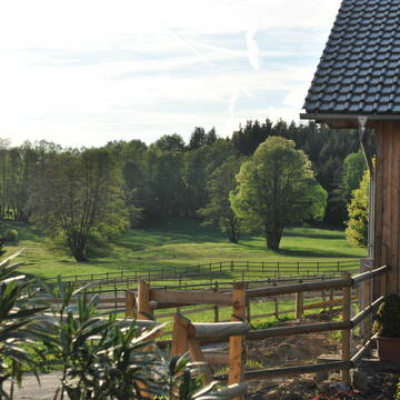
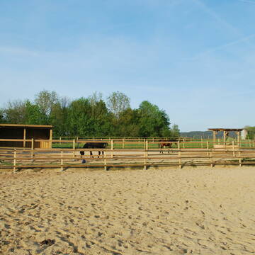
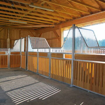
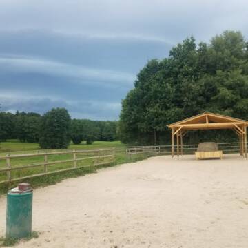
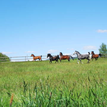
Reitanlage Gut Kirchhof
Haibach
Reitanlage-Gut-Kirchhof
@Reitanlage-Gut-Kirchhof
Freizeitstall
Pferdeausbildung
Vermieten
Hunde willkommen
Krankenbox
Außenboxen
Innenbox
16 weitere...
P+
Deprecated: Creation of dynamic property Zend_View_Helper_Ads::$adLink is deprecated in /var/www/stall-frei/htdocs/staging.stall-frei.de/library/Psf/View/Helper/Ads.php on line 108

Job gesucht?
Mechtersen
STALL-FREIde Marketing
@STALL-FREI-Marketing
Sie suchen einen Job und arbeiten gerne mit Pferden oder auf Reitanlagen?
Besuchen Sie jetzt unseren Stellenmarkt!


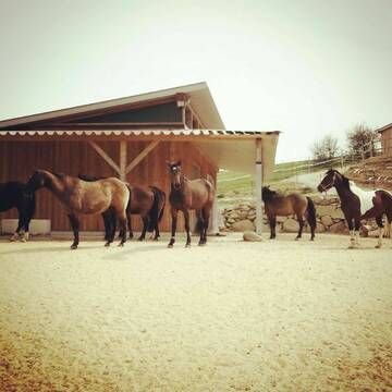
Pferdeboxen/Stallplätze/Einstellplätze
Bogen
Steven Schwarz
@BlackHillsideRanch
Freizeitstall
Geländestrecke
Hunde willkommen
Paddock
Gnadenbrothof
Hufrehe geeignet
Innenbox
12 weitere...
P+


Wohnen mit Pferd(en) oder Offenstallplätze
Falkenstein
KnallerbsenHof
@KnallerbsenHof
Vermieten
Hunde willkommen
Parkplatz für Pferdeanhänger
Offenstall
Selbstversorgung
8 weitere...
P+


Offenstallplätze/Einstellplätze im Pferdeparadie...
arnbruck
Pferdegut
@Pferdegut
Freizeitstall
Vermieten
Krankenbox
Paddock
Offenstall
6 weitere...
P+

Reitschule Gold - RFV Mitterfels e.V.
Mitterfels
Reitschule Gold
@ReitschuleGold
Freizeitstall
Reitlehrer und -unterricht
Vermieten
Hunde willkommen
Laufband
Außenboxen
Innenbox
16 weitere...
P

Pferdepension Hit Aktivstall Kürmerhof
Hohenkammer
Kuermerhof
@Kuermerhof
*******JETZT NEU MIT ENTSTAUBTEM BIOHEU*********
*******Demnächst mit einem Abenteuerspielplatz für Pferde ( Extrem Trail/Pa

Reitanlage, Reiterhof zu verpachten
Falkenstein
Frank Dietz
@Reitanlage-Saffelberg
Verpachten
Hunde willkommen
Krankenbox
Allergikerstall
bedampftes/gewaschenes Heu
Bewegungsstall
Offenstall
25 weitere...
P
Leider kein Vorschaubild
Leider kein Vorschaubild
Aktivstall, Offenstall in Ascha, Platz frei
Ascha
Daniela Foierl
@daniela-foierl
Vermieten
Hunde willkommen
Krankenbox
Fohlenaufzucht möglich
Hufrehe geeignet
Bewegungsstall
Laufstall
17 weitere...
B
Leider kein Vorschaubild
Leider kein Vorschaubild
aktuell
B
Leider kein Vorschaubild
Leider kein Vorschaubild
Box/Paddock frei
Ascha
Reitstall Susan-Peikert
@Reitstall-Susan-Peikert
Fahrstall, Kutschwagen
Freizeitstall
Vermieten
Hunde willkommen
Krankenbox
Gnadenbrothof
Hengsthaltung möglich
23 weitere...
B
Aktivstall Strahl, Bewegungsstall, Laufstall
Rettenbach
Aktivstall-Strahl
@Aktivstall-Strahl
Freizeitstall
Pferdeausbildung
Krankenbox
Longierzirkel/Roundpen
Fohlenaufzucht möglich
Hengsthaltung möglich
Bewegungsstall
Laufstall
22 weitere...
P
Deprecated: Creation of dynamic property Zend_View::$pageCount is deprecated in /var/www/stall-frei/htdocs/staging.stall-frei.de/library/vendor/shardj/zf1-future/library/Zend/View/Abstract.php on line 308
Deprecated: Creation of dynamic property Zend_View::$itemCountPerPage is deprecated in /var/www/stall-frei/htdocs/staging.stall-frei.de/library/vendor/shardj/zf1-future/library/Zend/View/Abstract.php on line 308
Deprecated: Creation of dynamic property Zend_View::$first is deprecated in /var/www/stall-frei/htdocs/staging.stall-frei.de/library/vendor/shardj/zf1-future/library/Zend/View/Abstract.php on line 308
Deprecated: Creation of dynamic property Zend_View::$current is deprecated in /var/www/stall-frei/htdocs/staging.stall-frei.de/library/vendor/shardj/zf1-future/library/Zend/View/Abstract.php on line 308
Deprecated: Creation of dynamic property Zend_View::$last is deprecated in /var/www/stall-frei/htdocs/staging.stall-frei.de/library/vendor/shardj/zf1-future/library/Zend/View/Abstract.php on line 308
Deprecated: Creation of dynamic property Zend_View::$next is deprecated in /var/www/stall-frei/htdocs/staging.stall-frei.de/library/vendor/shardj/zf1-future/library/Zend/View/Abstract.php on line 308
Deprecated: Creation of dynamic property Zend_View::$pagesInRange is deprecated in /var/www/stall-frei/htdocs/staging.stall-frei.de/library/vendor/shardj/zf1-future/library/Zend/View/Abstract.php on line 308
Deprecated: Creation of dynamic property Zend_View::$firstPageInRange is deprecated in /var/www/stall-frei/htdocs/staging.stall-frei.de/library/vendor/shardj/zf1-future/library/Zend/View/Abstract.php on line 308
Deprecated: Creation of dynamic property Zend_View::$lastPageInRange is deprecated in /var/www/stall-frei/htdocs/staging.stall-frei.de/library/vendor/shardj/zf1-future/library/Zend/View/Abstract.php on line 308
Deprecated: Creation of dynamic property Zend_View::$currentItemCount is deprecated in /var/www/stall-frei/htdocs/staging.stall-frei.de/library/vendor/shardj/zf1-future/library/Zend/View/Abstract.php on line 308
Deprecated: Creation of dynamic property Zend_View::$totalItemCount is deprecated in /var/www/stall-frei/htdocs/staging.stall-frei.de/library/vendor/shardj/zf1-future/library/Zend/View/Abstract.php on line 308
Deprecated: Creation of dynamic property Zend_View::$firstItemNumber is deprecated in /var/www/stall-frei/htdocs/staging.stall-frei.de/library/vendor/shardj/zf1-future/library/Zend/View/Abstract.php on line 308
Deprecated: Creation of dynamic property Zend_View::$lastItemNumber is deprecated in /var/www/stall-frei/htdocs/staging.stall-frei.de/library/vendor/shardj/zf1-future/library/Zend/View/Abstract.php on line 308
Deprecated: Creation of dynamic property Zend_View::$router is deprecated in /var/www/stall-frei/htdocs/staging.stall-frei.de/library/vendor/shardj/zf1-future/library/Zend/View/Abstract.php on line 308
Deprecated: Creation of dynamic property Zend_View::$urlParams is deprecated in /var/www/stall-frei/htdocs/staging.stall-frei.de/library/vendor/shardj/zf1-future/library/Zend/View/Abstract.php on line 308
Deprecated: Creation of dynamic property Zend_View::$showAds is deprecated in /var/www/stall-frei/htdocs/staging.stall-frei.de/library/vendor/shardj/zf1-future/library/Zend/View/Abstract.php on line 308
Deprecated: Creation of dynamic property Zend_View::$objectIds is deprecated in /var/www/stall-frei/htdocs/staging.stall-frei.de/library/vendor/shardj/zf1-future/library/Zend/View/Abstract.php on line 308
Deprecated: Creation of dynamic property Zend_View::$showNavbar is deprecated in /var/www/stall-frei/htdocs/staging.stall-frei.de/library/vendor/shardj/zf1-future/library/Zend/View/Abstract.php on line 308
Deprecated: Creation of dynamic property Zend_View::$showBreadcrumb is deprecated in /var/www/stall-frei/htdocs/staging.stall-frei.de/library/vendor/shardj/zf1-future/library/Zend/View/Abstract.php on line 308
Deprecated: Creation of dynamic property Zend_View::$showFooter is deprecated in /var/www/stall-frei/htdocs/staging.stall-frei.de/library/vendor/shardj/zf1-future/library/Zend/View/Abstract.php on line 308
Deprecated: Creation of dynamic property Zend_View::$showInternalAds is deprecated in /var/www/stall-frei/htdocs/staging.stall-frei.de/library/vendor/shardj/zf1-future/library/Zend/View/Abstract.php on line 308
Deprecated: Creation of dynamic property Zend_View::$blNoContent is deprecated in /var/www/stall-frei/htdocs/staging.stall-frei.de/library/vendor/shardj/zf1-future/library/Zend/View/Abstract.php on line 308
Deprecated: Creation of dynamic property Zend_View::$sMetaDesc is deprecated in /var/www/stall-frei/htdocs/staging.stall-frei.de/library/vendor/shardj/zf1-future/library/Zend/View/Abstract.php on line 308
Deprecated: Creation of dynamic property Zend_View::$useGmaps is deprecated in /var/www/stall-frei/htdocs/staging.stall-frei.de/library/vendor/shardj/zf1-future/library/Zend/View/Abstract.php on line 308
Deprecated: Creation of dynamic property Zend_View::$touches is deprecated in /var/www/stall-frei/htdocs/staging.stall-frei.de/library/vendor/shardj/zf1-future/library/Zend/View/Abstract.php on line 308
Deprecated: Creation of dynamic property Zend_View::$oProject is deprecated in /var/www/stall-frei/htdocs/staging.stall-frei.de/library/vendor/shardj/zf1-future/library/Zend/View/Abstract.php on line 308
Deprecated: Creation of dynamic property Zend_View::$pageHeadline is deprecated in /var/www/stall-frei/htdocs/staging.stall-frei.de/library/vendor/shardj/zf1-future/library/Zend/View/Abstract.php on line 308
Deprecated: Creation of dynamic property Zend_View::$disableLocationField is deprecated in /var/www/stall-frei/htdocs/staging.stall-frei.de/library/vendor/shardj/zf1-future/library/Zend/View/Abstract.php on line 308
Deprecated: Creation of dynamic property Zend_View::$isSearch is deprecated in /var/www/stall-frei/htdocs/staging.stall-frei.de/library/vendor/shardj/zf1-future/library/Zend/View/Abstract.php on line 308
Deprecated: Creation of dynamic property Zend_View::$pageTitle is deprecated in /var/www/stall-frei/htdocs/staging.stall-frei.de/library/vendor/shardj/zf1-future/library/Zend/View/Abstract.php on line 308
Deprecated: Creation of dynamic property Psf_Form_Element_Text::$class is deprecated in /var/www/stall-frei/htdocs/staging.stall-frei.de/library/vendor/shardj/zf1-future/library/Zend/Form/Element.php on line 874
Deprecated: Creation of dynamic property Psf_Form_Element_Text::$size is deprecated in /var/www/stall-frei/htdocs/staging.stall-frei.de/library/vendor/shardj/zf1-future/library/Zend/Form/Element.php on line 874
Deprecated: Creation of dynamic property Psf_Form_Element_Text::$placeholder is deprecated in /var/www/stall-frei/htdocs/staging.stall-frei.de/library/vendor/shardj/zf1-future/library/Zend/Form/Element.php on line 874
Deprecated: Creation of dynamic property Psf_Form_Element_Hidden::$class is deprecated in /var/www/stall-frei/htdocs/staging.stall-frei.de/library/vendor/shardj/zf1-future/library/Zend/Form/Element.php on line 874
Deprecated: Creation of dynamic property Psf_Form_Element_Hidden::$class is deprecated in /var/www/stall-frei/htdocs/staging.stall-frei.de/library/vendor/shardj/zf1-future/library/Zend/Form/Element.php on line 874
Deprecated: Creation of dynamic property Psf_Form_Element_Hidden::$class is deprecated in /var/www/stall-frei/htdocs/staging.stall-frei.de/library/vendor/shardj/zf1-future/library/Zend/Form/Element.php on line 874
Deprecated: Creation of dynamic property Psf_Form_Element_Hidden::$class is deprecated in /var/www/stall-frei/htdocs/staging.stall-frei.de/library/vendor/shardj/zf1-future/library/Zend/Form/Element.php on line 874
Deprecated: Creation of dynamic property Psf_Form_Element_Select::$class is deprecated in /var/www/stall-frei/htdocs/staging.stall-frei.de/library/vendor/shardj/zf1-future/library/Zend/Form/Element.php on line 874
Deprecated: Creation of dynamic property Psf_Form_Element_Select::$class is deprecated in /var/www/stall-frei/htdocs/staging.stall-frei.de/library/vendor/shardj/zf1-future/library/Zend/Form/Element.php on line 874
Deprecated: Creation of dynamic property Psf_Form_Element_Select::$class is deprecated in /var/www/stall-frei/htdocs/staging.stall-frei.de/library/vendor/shardj/zf1-future/library/Zend/Form/Element.php on line 874
Deprecated: Creation of dynamic property Psf_Form_Element_Select::$class is deprecated in /var/www/stall-frei/htdocs/staging.stall-frei.de/library/vendor/shardj/zf1-future/library/Zend/Form/Element.php on line 874
Deprecated: Creation of dynamic property Psf_Form_Element_Text::$class is deprecated in /var/www/stall-frei/htdocs/staging.stall-frei.de/library/vendor/shardj/zf1-future/library/Zend/Form/Element.php on line 874
Deprecated: Creation of dynamic property Psf_Form_Element_Checkbox::$label is deprecated in /var/www/stall-frei/htdocs/staging.stall-frei.de/library/vendor/shardj/zf1-future/library/Zend/Form/Element.php on line 874
Deprecated: Creation of dynamic property Zend_View::$sort is deprecated in /var/www/stall-frei/htdocs/staging.stall-frei.de/library/vendor/shardj/zf1-future/library/Zend/View/Abstract.php on line 308
Deprecated: Creation of dynamic property Zend_View::$searchLocation is deprecated in /var/www/stall-frei/htdocs/staging.stall-frei.de/library/vendor/shardj/zf1-future/library/Zend/View/Abstract.php on line 308
Deprecated: Creation of dynamic property Zend_View::$locationHint is deprecated in /var/www/stall-frei/htdocs/staging.stall-frei.de/library/vendor/shardj/zf1-future/library/Zend/View/Abstract.php on line 308
Psf_GeoCoder_Abstract::getLocation: Rattenberg Get Location CachedOrLive
Psf_GeoCoder_Abstract::getCachedOrLive: Rattenberg
Psf_GeoCoder_OpenCageData::makeApiRequest: response:
Array
(
[documentation] => https://opencagedata.com/api
[licenses] => Array
(
[0] => Array
(
[name] => see attribution guide
[url] => https://opencagedata.com/credits
)
)
[results] => Array
(
[0] => Array
(
[bounds] => Array
(
[northeast] => Array
(
[lat] => 49.1196949
[lng] => 12.8061046
)
[southwest] => Array
(
[lat] => 49.0376419
[lng] => 12.7180571
)
)
[components] => Array
(
[ISO_3166-1_alpha-2] => DE
[ISO_3166-1_alpha-3] => DEU
[ISO_3166-2] => Array
(
[0] => DE-BY
)
[_category] => place
[_normalized_city] => Rattenberg
[_type] => village
[continent] => Europe
[country] => Deutschland
[country_code] => de
[county] => Landkreis Straubing-Bogen
[political_union] => European Union
[postcode] => 94371
[state] => Bayern
[state_code] => BY
[village] => Rattenberg
)
[confidence] => 7
[formatted] => 94371 Rattenberg, Deutschland
[geometry] => Array
(
[lat] => 49.0857558
[lng] => 12.7523514
)
)
[1] => Array
(
[bounds] => Array
(
[northeast] => Array
(
[lat] => 51.8366021
[lng] => 9.3473342
)
[southwest] => Array
(
[lat] => 51.8365021
[lng] => 9.3472342
)
)
[components] => Array
(
[ISO_3166-1_alpha-2] => DE
[ISO_3166-1_alpha-3] => DEU
[ISO_3166-2] => Array
(
[0] => DE-NW
)
[_category] => natural/water
[_normalized_city] => Höxter
[_type] => peak
[continent] => Europe
[country] => Deutschland
[country_code] => de
[county] => Kreis Höxter
[municipality] => Höxter
[peak] => Rattenberg
[political_union] => European Union
[state] => Nordrhein-Westfalen
[state_code] => NW
)
[confidence] => 9
[formatted] => Rattenberg, Höxter, Nordrhein-Westfalen, Deutschland
[geometry] => Array
(
[lat] => 51.8365521
[lng] => 9.3472842
)
)
[2] => Array
(
[bounds] => Array
(
[northeast] => Array
(
[lat] => 51.1464219
[lng] => 7.2603349
)
[southwest] => Array
(
[lat] => 51.1463219
[lng] => 7.2602349
)
)
[components] => Array
(
[ISO_3166-1_alpha-2] => DE
[ISO_3166-1_alpha-3] => DEU
[ISO_3166-2] => Array
(
[0] => DE-NW
)
[_category] => natural/water
[_normalized_city] => Wermelskirchen
[_type] => peak
[continent] => Europe
[country] => Deutschland
[country_code] => de
[county] => Rheinisch-Bergischer Kreis
[peak] => Rattenberg
[political_union] => European Union
[postcode] => 42897
[state] => Nordrhein-Westfalen
[state_code] => NW
[town] => Wermelskirchen
)
[confidence] => 9
[formatted] => Rattenberg, 42897 Wermelskirchen, Deutschland
[geometry] => Array
(
[lat] => 51.1463719
[lng] => 7.2602849
)
)
[3] => Array
(
[bounds] => Array
(
[northeast] => Array
(
[lat] => 48.2248814
[lng] => 12.3392456
)
[southwest] => Array
(
[lat] => 48.1848814
[lng] => 12.2992456
)
)
[components] => Array
(
[ISO_3166-1_alpha-2] => DE
[ISO_3166-1_alpha-3] => DEU
[ISO_3166-2] => Array
(
[0] => DE-BY
)
[_category] => place
[_normalized_city] => Aschau am Inn
[_type] => hamlet
[continent] => Europe
[country] => Deutschland
[country_code] => de
[county] => Landkreis Mühldorf am Inn
[hamlet] => Rattenberg
[political_union] => European Union
[postcode] => 83546
[state] => Bayern
[state_code] => BY
[village] => Aschau am Inn
)
[confidence] => 7
[formatted] => Rattenberg, 83546 Aschau am Inn, Deutschland
[geometry] => Array
(
[lat] => 48.2048814
[lng] => 12.3192456
)
)
[4] => Array
(
[bounds] => Array
(
[northeast] => Array
(
[lat] => 49.6000089
[lng] => 12.2132945
)
[southwest] => Array
(
[lat] => 49.5600089
[lng] => 12.1732945
)
)
[components] => Array
(
[ISO_3166-1_alpha-2] => DE
[ISO_3166-1_alpha-3] => DEU
[ISO_3166-2] => Array
(
[0] => DE-BY
)
[_category] => place
[_normalized_city] => Wernberg-Köblitz
[_type] => hamlet
[continent] => Europe
[country] => Deutschland
[country_code] => de
[county] => Landkreis Schwandorf
[hamlet] => Rattenberg
[municipality] => Wernberg-Köblitz
[political_union] => European Union
[state] => Bayern
[state_code] => BY
)
[confidence] => 7
[formatted] => Rattenberg, Bayern, Deutschland
[geometry] => Array
(
[lat] => 49.5800089
[lng] => 12.1932945
)
)
[5] => Array
(
[components] => Array
(
[ISO_3166-1_alpha-2] => FR
[ISO_3166-1_alpha-3] => FRA
[ISO_3166-2] => Array
(
[0] => FR-GES
[1] => FR-6AE
[2] => FR-67
)
[_category] => road
[_normalized_city] => Châtenois
[_type] => road
[city] => Châtenois
[continent] => Europe
[country] => France
[country_code] => fr
[county] => Bas-Rhin
[local_authority] => Communauté de communes de Sélestat
[political_union] => European Union
[postcode] => 67730
[road] => Rue du Hattenberg
[state] => Grand Est
[state_code] => GES
)
[confidence] => 3
[formatted] => Rue du Hattenberg, 67730 Châtenois, France
[geometry] => Array
(
[lat] => 48.266426
[lng] => 7.402619
)
)
[6] => Array
(
[components] => Array
(
[ISO_3166-1_alpha-2] => FR
[ISO_3166-1_alpha-3] => FRA
[ISO_3166-2] => Array
(
[0] => FR-GES
[1] => FR-6AE
[2] => FR-67
)
[_category] => road
[_normalized_city] => Kintzheim
[_type] => road
[city] => Kintzheim
[continent] => Europe
[country] => France
[country_code] => fr
[county] => Bas-Rhin
[local_authority] => Communauté de communes de Sélestat
[political_union] => European Union
[postcode] => 67600
[road] => Chemin du Hattenberg
[state] => Grand Est
[state_code] => GES
)
[confidence] => 3
[formatted] => Chemin du Hattenberg, 67600 Kintzheim, France
[geometry] => Array
(
[lat] => 48.260798
[lng] => 7.405248
)
)
[7] => Array
(
[components] => Array
(
[ISO_3166-1_alpha-2] => FR
[ISO_3166-1_alpha-3] => FRA
[ISO_3166-2] => Array
(
[0] => FR-GES
[1] => FR-6AE
[2] => FR-67
)
[_category] => road
[_normalized_city] => Zinswiller
[_type] => road
[city] => Zinswiller
[continent] => Europe
[country] => France
[country_code] => fr
[county] => Bas-Rhin
[local_authority] => Communauté de communes du Pays de Niederbronn-les-Bains
[political_union] => European Union
[postcode] => 67110
[road] => Rue Mattenberg
[state] => Grand Est
[state_code] => GES
)
[confidence] => 3
[formatted] => Rue Mattenberg, 67110 Zinswiller, France
[geometry] => Array
(
[lat] => 48.914906
[lng] => 7.596459
)
)
[8] => Array
(
[components] => Array
(
[ISO_3166-1_alpha-2] => FR
[ISO_3166-1_alpha-3] => FRA
[ISO_3166-2] => Array
(
[0] => FR-GES
[1] => FR-6AE
[2] => FR-67
)
[_category] => road
[_normalized_city] => Dambach-la-Ville
[_type] => road
[city] => Dambach-la-Ville
[continent] => Europe
[country] => France
[country_code] => fr
[county] => Bas-Rhin
[local_authority] => Communauté de communes du Pays de Barr
[political_union] => European Union
[postcode] => 67650
[road] => Chemin du Rutenberg
[state] => Grand Est
[state_code] => GES
)
[confidence] => 3
[formatted] => Chemin du Rutenberg, 67650 Dambach-la-Ville, France
[geometry] => Array
(
[lat] => 48.320128
[lng] => 7.42426
)
)
[9] => Array
(
[components] => Array
(
[ISO_3166-1_alpha-2] => FR
[ISO_3166-1_alpha-3] => FRA
[ISO_3166-2] => Array
(
[0] => FR-GES
[1] => FR-6AE
[2] => FR-68
)
[_category] => road
[_normalized_city] => Ribeauvillé
[_type] => road
[city] => Ribeauvillé
[continent] => Europe
[country] => France
[country_code] => fr
[county] => Haut-Rhin
[local_authority] => Communauté de communes du Pays de Ribeauvillé
[political_union] => European Union
[postcode] => 68150
[road] => Chemin du Rotenberg
[state] => Grand Est
[state_code] => GES
)
[confidence] => 2
[formatted] => Chemin du Rotenberg, 68150 Ribeauvillé, France
[geometry] => Array
(
[lat] => 48.19534
[lng] => 7.345753
)
)
)
[status] => Array
(
[code] => 200
[message] => OK
)
[stay_informed] => Array
(
[blog] => https://blog.opencagedata.com
[mastodon] => https://en.osm.town/@opencage
)
[thanks] => For using an OpenCage API
[timestamp] => Array
(
[created_http] => Mon, 09 Feb 2026 05:40:56 GMT
[created_unix] => 1770615656
)
[total_results] => 10
)
Psf_GeoCoder_Abstract::convertLocationResult
{"documentation":"https:\/\/opencagedata.com\/api","licenses":[{"name":"see attribution guide","url":"https:\/\/opencagedata.com\/credits"}],"results":[{"bounds":{"northeast":{"lat":49.1196949,"lng":12.8061046},"southwest":{"lat":49.0376419,"lng":12.7180571}},"components":{"ISO_3166-1_alpha-2":"DE","ISO_3166-1_alpha-3":"DEU","ISO_3166-2":["DE-BY"],"_category":"place","_normalized_city":"Rattenberg","_type":"village","continent":"Europe","country":"Deutschland","country_code":"de","county":"Landkreis Straubing-Bogen","political_union":"European Union","postcode":"94371","state":"Bayern","state_code":"BY","village":"Rattenberg"},"confidence":7,"formatted":"94371 Rattenberg, Deutschland","geometry":{"lat":49.0857558,"lng":12.7523514}},{"bounds":{"northeast":{"lat":51.8366021,"lng":9.3473342},"southwest":{"lat":51.8365021,"lng":9.3472342}},"components":{"ISO_3166-1_alpha-2":"DE","ISO_3166-1_alpha-3":"DEU","ISO_3166-2":["DE-NW"],"_category":"natural\/water","_normalized_city":"H\u00f6xter","_type":"peak","continent":"Europe","country":"Deutschland","country_code":"de","county":"Kreis H\u00f6xter","municipality":"H\u00f6xter","peak":"Rattenberg","political_union":"European Union","state":"Nordrhein-Westfalen","state_code":"NW"},"confidence":9,"formatted":"Rattenberg, H\u00f6xter, Nordrhein-Westfalen, Deutschland","geometry":{"lat":51.8365521,"lng":9.3472842}},{"bounds":{"northeast":{"lat":51.1464219,"lng":7.2603349},"southwest":{"lat":51.1463219,"lng":7.2602349}},"components":{"ISO_3166-1_alpha-2":"DE","ISO_3166-1_alpha-3":"DEU","ISO_3166-2":["DE-NW"],"_category":"natural\/water","_normalized_city":"Wermelskirchen","_type":"peak","continent":"Europe","country":"Deutschland","country_code":"de","county":"Rheinisch-Bergischer Kreis","peak":"Rattenberg","political_union":"European Union","postcode":"42897","state":"Nordrhein-Westfalen","state_code":"NW","town":"Wermelskirchen"},"confidence":9,"formatted":"Rattenberg, 42897 Wermelskirchen, Deutschland","geometry":{"lat":51.1463719,"lng":7.2602849}},{"bounds":{"northeast":{"lat":48.2248814,"lng":12.3392456},"southwest":{"lat":48.1848814,"lng":12.2992456}},"components":{"ISO_3166-1_alpha-2":"DE","ISO_3166-1_alpha-3":"DEU","ISO_3166-2":["DE-BY"],"_category":"place","_normalized_city":"Aschau am Inn","_type":"hamlet","continent":"Europe","country":"Deutschland","country_code":"de","county":"Landkreis M\u00fchldorf am Inn","hamlet":"Rattenberg","political_union":"European Union","postcode":"83546","state":"Bayern","state_code":"BY","village":"Aschau am Inn"},"confidence":7,"formatted":"Rattenberg, 83546 Aschau am Inn, Deutschland","geometry":{"lat":48.2048814,"lng":12.3192456}},{"bounds":{"northeast":{"lat":49.6000089,"lng":12.2132945},"southwest":{"lat":49.5600089,"lng":12.1732945}},"components":{"ISO_3166-1_alpha-2":"DE","ISO_3166-1_alpha-3":"DEU","ISO_3166-2":["DE-BY"],"_category":"place","_normalized_city":"Wernberg-K\u00f6blitz","_type":"hamlet","continent":"Europe","country":"Deutschland","country_code":"de","county":"Landkreis Schwandorf","hamlet":"Rattenberg","municipality":"Wernberg-K\u00f6blitz","political_union":"European Union","state":"Bayern","state_code":"BY"},"confidence":7,"formatted":"Rattenberg, Bayern, Deutschland","geometry":{"lat":49.5800089,"lng":12.1932945}},{"components":{"ISO_3166-1_alpha-2":"FR","ISO_3166-1_alpha-3":"FRA","ISO_3166-2":["FR-GES","FR-6AE","FR-67"],"_category":"road","_normalized_city":"Ch\u00e2tenois","_type":"road","city":"Ch\u00e2tenois","continent":"Europe","country":"France","country_code":"fr","county":"Bas-Rhin","local_authority":"Communaut\u00e9 de communes de S\u00e9lestat","political_union":"European Union","postcode":"67730","road":"Rue du Hattenberg","state":"Grand Est","state_code":"GES"},"confidence":3,"formatted":"Rue du Hattenberg, 67730 Ch\u00e2tenois, France","geometry":{"lat":48.266426,"lng":7.402619}},{"components":{"ISO_3166-1_alpha-2":"FR","ISO_3166-1_alpha-3":"FRA","ISO_3166-2":["FR-GES","FR-6AE","FR-67"],"_category":"road","_normalized_city":"Kintzheim","_type":"road","city":"Kintzheim","continent":"Europe","country":"France","country_code":"fr","county":"Bas-Rhin","local_authority":"Communaut\u00e9 de communes de S\u00e9lestat","political_union":"European Union","postcode":"67600","road":"Chemin du Hattenberg","state":"Grand Est","state_code":"GES"},"confidence":3,"formatted":"Chemin du Hattenberg, 67600 Kintzheim, France","geometry":{"lat":48.260798,"lng":7.405248}},{"components":{"ISO_3166-1_alpha-2":"FR","ISO_3166-1_alpha-3":"FRA","ISO_3166-2":["FR-GES","FR-6AE","FR-67"],"_category":"road","_normalized_city":"Zinswiller","_type":"road","city":"Zinswiller","continent":"Europe","country":"France","country_code":"fr","county":"Bas-Rhin","local_authority":"Communaut\u00e9 de communes du Pays de Niederbronn-les-Bains","political_union":"European Union","postcode":"67110","road":"Rue Mattenberg","state":"Grand Est","state_code":"GES"},"confidence":3,"formatted":"Rue Mattenberg, 67110 Zinswiller, France","geometry":{"lat":48.914906,"lng":7.596459}},{"components":{"ISO_3166-1_alpha-2":"FR","ISO_3166-1_alpha-3":"FRA","ISO_3166-2":["FR-GES","FR-6AE","FR-67"],"_category":"road","_normalized_city":"Dambach-la-Ville","_type":"road","city":"Dambach-la-Ville","continent":"Europe","country":"France","country_code":"fr","county":"Bas-Rhin","local_authority":"Communaut\u00e9 de communes du Pays de Barr","political_union":"European Union","postcode":"67650","road":"Chemin du Rutenberg","state":"Grand Est","state_code":"GES"},"confidence":3,"formatted":"Chemin du Rutenberg, 67650 Dambach-la-Ville, France","geometry":{"lat":48.320128,"lng":7.42426}},{"components":{"ISO_3166-1_alpha-2":"FR","ISO_3166-1_alpha-3":"FRA","ISO_3166-2":["FR-GES","FR-6AE","FR-68"],"_category":"road","_normalized_city":"Ribeauvill\u00e9","_type":"road","city":"Ribeauvill\u00e9","continent":"Europe","country":"France","country_code":"fr","county":"Haut-Rhin","local_authority":"Communaut\u00e9 de communes du Pays de Ribeauvill\u00e9","political_union":"European Union","postcode":"68150","road":"Chemin du Rotenberg","state":"Grand Est","state_code":"GES"},"confidence":2,"formatted":"Chemin du Rotenberg, 68150 Ribeauvill\u00e9, France","geometry":{"lat":48.19534,"lng":7.345753}}],"status":{"code":200,"message":"OK"},"stay_informed":{"blog":"https:\/\/blog.opencagedata.com","mastodon":"https:\/\/en.osm.town\/@opencage"},"thanks":"For using an OpenCage API","timestamp":{"created_http":"Mon, 09 Feb 2026 05:40:56 GMT","created_unix":1770615656},"total_results":10}Array
(
[0] => stdClass Object
(
[bounds] => stdClass Object
(
[northeast] => stdClass Object
(
[lat] => 49.1196949
[lng] => 12.8061046
)
[southwest] => stdClass Object
(
[lat] => 49.0376419
[lng] => 12.7180571
)
)
[components] => stdClass Object
(
[ISO_3166-1_alpha-2] => DE
[ISO_3166-1_alpha-3] => DEU
[ISO_3166-2] => Array
(
[0] => DE-BY
)
[_category] => place
[_normalized_city] => Rattenberg
[_type] => village
[continent] => Europe
[country] => Deutschland
[country_code] => de
[county] => Landkreis Straubing-Bogen
[political_union] => European Union
[postcode] => 94371
[state] => Bayern
[state_code] => BY
[village] => Rattenberg
)
[confidence] => 7
[formatted] => 94371 Rattenberg, Deutschland
[geometry] => stdClass Object
(
[lat] => 49.0857558
[lng] => 12.7523514
)
)
[1] => stdClass Object
(
[bounds] => stdClass Object
(
[northeast] => stdClass Object
(
[lat] => 51.8366021
[lng] => 9.3473342
)
[southwest] => stdClass Object
(
[lat] => 51.8365021
[lng] => 9.3472342
)
)
[components] => stdClass Object
(
[ISO_3166-1_alpha-2] => DE
[ISO_3166-1_alpha-3] => DEU
[ISO_3166-2] => Array
(
[0] => DE-NW
)
[_category] => natural/water
[_normalized_city] => Höxter
[_type] => peak
[continent] => Europe
[country] => Deutschland
[country_code] => de
[county] => Kreis Höxter
[municipality] => Höxter
[peak] => Rattenberg
[political_union] => European Union
[state] => Nordrhein-Westfalen
[state_code] => NW
)
[confidence] => 9
[formatted] => Rattenberg, Höxter, Nordrhein-Westfalen, Deutschland
[geometry] => stdClass Object
(
[lat] => 51.8365521
[lng] => 9.3472842
)
)
[2] => stdClass Object
(
[bounds] => stdClass Object
(
[northeast] => stdClass Object
(
[lat] => 51.1464219
[lng] => 7.2603349
)
[southwest] => stdClass Object
(
[lat] => 51.1463219
[lng] => 7.2602349
)
)
[components] => stdClass Object
(
[ISO_3166-1_alpha-2] => DE
[ISO_3166-1_alpha-3] => DEU
[ISO_3166-2] => Array
(
[0] => DE-NW
)
[_category] => natural/water
[_normalized_city] => Wermelskirchen
[_type] => peak
[continent] => Europe
[country] => Deutschland
[country_code] => de
[county] => Rheinisch-Bergischer Kreis
[peak] => Rattenberg
[political_union] => European Union
[postcode] => 42897
[state] => Nordrhein-Westfalen
[state_code] => NW
[town] => Wermelskirchen
)
[confidence] => 9
[formatted] => Rattenberg, 42897 Wermelskirchen, Deutschland
[geometry] => stdClass Object
(
[lat] => 51.1463719
[lng] => 7.2602849
)
)
[3] => stdClass Object
(
[bounds] => stdClass Object
(
[northeast] => stdClass Object
(
[lat] => 48.2248814
[lng] => 12.3392456
)
[southwest] => stdClass Object
(
[lat] => 48.1848814
[lng] => 12.2992456
)
)
[components] => stdClass Object
(
[ISO_3166-1_alpha-2] => DE
[ISO_3166-1_alpha-3] => DEU
[ISO_3166-2] => Array
(
[0] => DE-BY
)
[_category] => place
[_normalized_city] => Aschau am Inn
[_type] => hamlet
[continent] => Europe
[country] => Deutschland
[country_code] => de
[county] => Landkreis Mühldorf am Inn
[hamlet] => Rattenberg
[political_union] => European Union
[postcode] => 83546
[state] => Bayern
[state_code] => BY
[village] => Aschau am Inn
)
[confidence] => 7
[formatted] => Rattenberg, 83546 Aschau am Inn, Deutschland
[geometry] => stdClass Object
(
[lat] => 48.2048814
[lng] => 12.3192456
)
)
[4] => stdClass Object
(
[bounds] => stdClass Object
(
[northeast] => stdClass Object
(
[lat] => 49.6000089
[lng] => 12.2132945
)
[southwest] => stdClass Object
(
[lat] => 49.5600089
[lng] => 12.1732945
)
)
[components] => stdClass Object
(
[ISO_3166-1_alpha-2] => DE
[ISO_3166-1_alpha-3] => DEU
[ISO_3166-2] => Array
(
[0] => DE-BY
)
[_category] => place
[_normalized_city] => Wernberg-Köblitz
[_type] => hamlet
[continent] => Europe
[country] => Deutschland
[country_code] => de
[county] => Landkreis Schwandorf
[hamlet] => Rattenberg
[municipality] => Wernberg-Köblitz
[political_union] => European Union
[state] => Bayern
[state_code] => BY
)
[confidence] => 7
[formatted] => Rattenberg, Bayern, Deutschland
[geometry] => stdClass Object
(
[lat] => 49.5800089
[lng] => 12.1932945
)
)
[5] => stdClass Object
(
[components] => stdClass Object
(
[ISO_3166-1_alpha-2] => FR
[ISO_3166-1_alpha-3] => FRA
[ISO_3166-2] => Array
(
[0] => FR-GES
[1] => FR-6AE
[2] => FR-67
)
[_category] => road
[_normalized_city] => Châtenois
[_type] => road
[city] => Châtenois
[continent] => Europe
[country] => France
[country_code] => fr
[county] => Bas-Rhin
[local_authority] => Communauté de communes de Sélestat
[political_union] => European Union
[postcode] => 67730
[road] => Rue du Hattenberg
[state] => Grand Est
[state_code] => GES
)
[confidence] => 3
[formatted] => Rue du Hattenberg, 67730 Châtenois, France
[geometry] => stdClass Object
(
[lat] => 48.266426
[lng] => 7.402619
)
)
[6] => stdClass Object
(
[components] => stdClass Object
(
[ISO_3166-1_alpha-2] => FR
[ISO_3166-1_alpha-3] => FRA
[ISO_3166-2] => Array
(
[0] => FR-GES
[1] => FR-6AE
[2] => FR-67
)
[_category] => road
[_normalized_city] => Kintzheim
[_type] => road
[city] => Kintzheim
[continent] => Europe
[country] => France
[country_code] => fr
[county] => Bas-Rhin
[local_authority] => Communauté de communes de Sélestat
[political_union] => European Union
[postcode] => 67600
[road] => Chemin du Hattenberg
[state] => Grand Est
[state_code] => GES
)
[confidence] => 3
[formatted] => Chemin du Hattenberg, 67600 Kintzheim, France
[geometry] => stdClass Object
(
[lat] => 48.260798
[lng] => 7.405248
)
)
[7] => stdClass Object
(
[components] => stdClass Object
(
[ISO_3166-1_alpha-2] => FR
[ISO_3166-1_alpha-3] => FRA
[ISO_3166-2] => Array
(
[0] => FR-GES
[1] => FR-6AE
[2] => FR-67
)
[_category] => road
[_normalized_city] => Zinswiller
[_type] => road
[city] => Zinswiller
[continent] => Europe
[country] => France
[country_code] => fr
[county] => Bas-Rhin
[local_authority] => Communauté de communes du Pays de Niederbronn-les-Bains
[political_union] => European Union
[postcode] => 67110
[road] => Rue Mattenberg
[state] => Grand Est
[state_code] => GES
)
[confidence] => 3
[formatted] => Rue Mattenberg, 67110 Zinswiller, France
[geometry] => stdClass Object
(
[lat] => 48.914906
[lng] => 7.596459
)
)
[8] => stdClass Object
(
[components] => stdClass Object
(
[ISO_3166-1_alpha-2] => FR
[ISO_3166-1_alpha-3] => FRA
[ISO_3166-2] => Array
(
[0] => FR-GES
[1] => FR-6AE
[2] => FR-67
)
[_category] => road
[_normalized_city] => Dambach-la-Ville
[_type] => road
[city] => Dambach-la-Ville
[continent] => Europe
[country] => France
[country_code] => fr
[county] => Bas-Rhin
[local_authority] => Communauté de communes du Pays de Barr
[political_union] => European Union
[postcode] => 67650
[road] => Chemin du Rutenberg
[state] => Grand Est
[state_code] => GES
)
[confidence] => 3
[formatted] => Chemin du Rutenberg, 67650 Dambach-la-Ville, France
[geometry] => stdClass Object
(
[lat] => 48.320128
[lng] => 7.42426
)
)
[9] => stdClass Object
(
[components] => stdClass Object
(
[ISO_3166-1_alpha-2] => FR
[ISO_3166-1_alpha-3] => FRA
[ISO_3166-2] => Array
(
[0] => FR-GES
[1] => FR-6AE
[2] => FR-68
)
[_category] => road
[_normalized_city] => Ribeauvillé
[_type] => road
[city] => Ribeauvillé
[continent] => Europe
[country] => France
[country_code] => fr
[county] => Haut-Rhin
[local_authority] => Communauté de communes du Pays de Ribeauvillé
[political_union] => European Union
[postcode] => 68150
[road] => Chemin du Rotenberg
[state] => Grand Est
[state_code] => GES
)
[confidence] => 2
[formatted] => Chemin du Rotenberg, 68150 Ribeauvillé, France
[geometry] => stdClass Object
(
[lat] => 48.19534
[lng] => 7.345753
)
)
)
Psf_GeoCoder_OpenCageData::getKeyMap: 0
stdClass Object
(
    [bounds] => stdClass Object
        (
            [northeast] => stdClass Object
                (
                    [lat] => 49.1196949
                    [lng] => 12.8061046
                )

            [southwest] => stdClass Object
                (
                    [lat] => 49.0376419
                    [lng] => 12.7180571
                )

        )

    [components] => stdClass Object
        (
            [ISO_3166-1_alpha-2] => DE
            [ISO_3166-1_alpha-3] => DEU
            [ISO_3166-2] => Array
                (
                    [0] => DE-BY
                )

            [_category] => place
            [_normalized_city] => Rattenberg
            [_type] => village
            [continent] => Europe
            [country] => Deutschland
            [country_code] => de
            [county] => Landkreis Straubing-Bogen
            [political_union] => European Union
            [postcode] => 94371
            [state] => Bayern
            [state_code] => BY
            [village] => Rattenberg
        )

    [confidence] => 7
    [formatted] => 94371 Rattenberg, Deutschland
    [geometry] => stdClass Object
        (
            [lat] => 49.0857558
            [lng] => 12.7523514
        )

)
Psf_GeoCoder_OpenCageData::getCounty: Straubing-Bogen
Psf_GeoCoder_OpenCageData::addMissingData REFETCH!
Array
(
    [address] => 94371 Rattenberg, Deutschland
    [type] => village
    [street] =>
    [city] => Rattenberg
    [county] => Straubing-Bogen
    [state] => Bayern
    [zip] => 94371
    [country] => Deutschland
    [suburb] =>
    [countrycode] => de
    [latitude] => 49.0857558
    [longitude] => 12.7523514
    [accuracy] => 1
    [confidence] => 7
    [bounds] => stdClass Object
        (
            [northeast] => stdClass Object
                (
                    [lat] => 49.1196949
                    [lng] => 12.8061046
                )

            [southwest] => stdClass Object
                (
                    [lat] => 49.0376419
                    [lng] => 12.7180571
                )

        )

)
reformat!
Array
(
    [address] => 94371 Rattenberg, Deutschland
    [type] => village
    [street] =>
    [city] => Rattenberg
    [county] => Straubing-Bogen
    [state] => Bayern
    [zip] => 94371
    [country] => Deutschland
    [suburb] =>
    [countrycode] => de
    [latitude] => 49.0857558
    [longitude] => 12.7523514
    [accuracy] => 1
    [confidence] => 7
    [bounds] => stdClass Object
        (
            [northeast] => stdClass Object
                (
                    [lat] => 49.1196949
                    [lng] => 12.8061046
                )

            [southwest] => stdClass Object
                (
                    [lat] => 49.0376419
                    [lng] => 12.7180571
                )

        )

    [place] => 94371 Rattenberg, Bayern
    [hash] => 60328b872b195e76024a0b1dc9d7000e
)
Psf_GeoCoder_OpenCageData::getKeyMap: 1
stdClass Object
(
    [bounds] => stdClass Object
        (
            [northeast] => stdClass Object
                (
                    [lat] => 51.8366021
                    [lng] => 9.3473342
                )

            [southwest] => stdClass Object
                (
                    [lat] => 51.8365021
                    [lng] => 9.3472342
                )

        )

    [components] => stdClass Object
        (
            [ISO_3166-1_alpha-2] => DE
            [ISO_3166-1_alpha-3] => DEU
            [ISO_3166-2] => Array
                (
                    [0] => DE-NW
                )

            [_category] => natural/water
            [_normalized_city] => Höxter
            [_type] => peak
            [continent] => Europe
            [country] => Deutschland
            [country_code] => de
            [county] => Kreis Höxter
            [municipality] => Höxter
            [peak] => Rattenberg
            [political_union] => European Union
            [state] => Nordrhein-Westfalen
            [state_code] => NW
        )

    [confidence] => 9
    [formatted] => Rattenberg, Höxter, Nordrhein-Westfalen, Deutschland
    [geometry] => stdClass Object
        (
            [lat] => 51.8365521
            [lng] => 9.3472842
        )

)
Psf_GeoCoder_OpenCageData::getCounty: Höxter
Psf_GeoCoder_OpenCageData::addMissingData REFETCH!
Array
(
    [address] => Rattenberg, Höxter, Nordrhein-Westfalen, Deutschland
    [type] => peak
    [street] =>
    [city] =>
    [county] => Höxter
    [state] => Nordrhein-Westfalen
    [zip] =>
    [country] => Deutschland
    [suburb] =>
    [countrycode] => de
    [latitude] => 51.8365521
    [longitude] => 9.3472842
    [accuracy] => 1
    [confidence] => 9
    [bounds] => stdClass Object
        (
            [northeast] => stdClass Object
                (
                    [lat] => 51.8366021
                    [lng] => 9.3473342
                )

            [southwest] => stdClass Object
                (
                    [lat] => 51.8365021
                    [lng] => 9.3472342
                )

        )

)
reformat!
Array
(
    [address] => Rattenberg, Höxter, Nordrhein-Westfalen, Deutschland
    [type] => peak
    [street] =>
    [city] =>
    [county] => Höxter
    [state] => Nordrhein-Westfalen
    [zip] =>
    [country] => Deutschland
    [suburb] =>
    [countrycode] => de
    [latitude] => 51.8365521
    [longitude] => 9.3472842
    [accuracy] => 1
    [confidence] => 9
    [bounds] => stdClass Object
        (
            [northeast] => stdClass Object
                (
                    [lat] => 51.8366021
                    [lng] => 9.3473342
                )

            [southwest] => stdClass Object
                (
                    [lat] => 51.8365021
                    [lng] => 9.3472342
                )

        )

    [place] => , Nordrhein-Westfalen
    [hash] => 644b8c15c8948e95434516b8ef8d7312
)
Psf_GeoCoder_OpenCageData::getKeyMap: 2
stdClass Object
(
    [bounds] => stdClass Object
        (
            [northeast] => stdClass Object
                (
                    [lat] => 51.1464219
                    [lng] => 7.2603349
                )

            [southwest] => stdClass Object
                (
                    [lat] => 51.1463219
                    [lng] => 7.2602349
                )

        )

    [components] => stdClass Object
        (
            [ISO_3166-1_alpha-2] => DE
            [ISO_3166-1_alpha-3] => DEU
            [ISO_3166-2] => Array
                (
                    [0] => DE-NW
                )

            [_category] => natural/water
            [_normalized_city] => Wermelskirchen
            [_type] => peak
            [continent] => Europe
            [country] => Deutschland
            [country_code] => de
            [county] => Rheinisch-Bergischer Kreis
            [peak] => Rattenberg
            [political_union] => European Union
            [postcode] => 42897
            [state] => Nordrhein-Westfalen
            [state_code] => NW
            [town] => Wermelskirchen
        )

    [confidence] => 9
    [formatted] => Rattenberg, 42897 Wermelskirchen, Deutschland
    [geometry] => stdClass Object
        (
            [lat] => 51.1463719
            [lng] => 7.2602849
        )

)
Psf_GeoCoder_OpenCageData::getCounty: Rheinisch-Bergischer Kreis
Psf_GeoCoder_OpenCageData::addMissingData REFETCH!
Array
(
    [address] => Rattenberg, 42897 Wermelskirchen, Deutschland
    [type] => peak
    [street] =>
    [city] => Wermelskirchen
    [county] => Rheinisch-Bergischer Kreis
    [state] => Nordrhein-Westfalen
    [zip] => 42897
    [country] => Deutschland
    [suburb] =>
    [countrycode] => de
    [latitude] => 51.1463719
    [longitude] => 7.2602849
    [accuracy] => 1
    [confidence] => 9
    [bounds] => stdClass Object
        (
            [northeast] => stdClass Object
                (
                    [lat] => 51.1464219
                    [lng] => 7.2603349
                )

            [southwest] => stdClass Object
                (
                    [lat] => 51.1463219
                    [lng] => 7.2602349
                )

        )

)
reformat!
Array
(
    [address] => Rattenberg, 42897 Wermelskirchen, Deutschland
    [type] => peak
    [street] =>
    [city] => Wermelskirchen
    [county] => Rheinisch-Bergischer Kreis
    [state] => Nordrhein-Westfalen
    [zip] => 42897
    [country] => Deutschland
    [suburb] =>
    [countrycode] => de
    [latitude] => 51.1463719
    [longitude] => 7.2602849
    [accuracy] => 1
    [confidence] => 9
    [bounds] => stdClass Object
        (
            [northeast] => stdClass Object
                (
                    [lat] => 51.1464219
                    [lng] => 7.2603349
                )

            [southwest] => stdClass Object
                (
                    [lat] => 51.1463219
                    [lng] => 7.2602349
                )

        )

    [place] => 42897 Wermelskirchen, Nordrhein-Westfalen
    [hash] => 475730d5918c7f9ea73e65eb4301028b
)
Psf_GeoCoder_OpenCageData::getKeyMap: 3
stdClass Object
(
    [bounds] => stdClass Object
        (
            [northeast] => stdClass Object
                (
                    [lat] => 48.2248814
                    [lng] => 12.3392456
                )

            [southwest] => stdClass Object
                (
                    [lat] => 48.1848814
                    [lng] => 12.2992456
                )

        )

    [components] => stdClass Object
        (
            [ISO_3166-1_alpha-2] => DE
            [ISO_3166-1_alpha-3] => DEU
            [ISO_3166-2] => Array
                (
                    [0] => DE-BY
                )

            [_category] => place
            [_normalized_city] => Aschau am Inn
            [_type] => hamlet
            [continent] => Europe
            [country] => Deutschland
            [country_code] => de
            [county] => Landkreis Mühldorf am Inn
            [hamlet] => Rattenberg
            [political_union] => European Union
            [postcode] => 83546
            [state] => Bayern
            [state_code] => BY
            [village] => Aschau am Inn
        )

    [confidence] => 7
    [formatted] => Rattenberg, 83546 Aschau am Inn, Deutschland
    [geometry] => stdClass Object
        (
            [lat] => 48.2048814
            [lng] => 12.3192456
        )

)
Psf_GeoCoder_OpenCageData::getCounty: Mühldorf am Inn
Psf_GeoCoder_OpenCageData::addMissingData REFETCH!
Array
(
    [address] => Rattenberg, 83546 Aschau am Inn, Deutschland
    [type] => hamlet
    [street] => Rattenberg
    [city] => Aschau am Inn
    [county] => Mühldorf am Inn
    [state] => Bayern
    [zip] => 83546
    [country] => Deutschland
    [suburb] =>
    [countrycode] => de
    [latitude] => 48.2048814
    [longitude] => 12.3192456
    [accuracy] => 1
    [confidence] => 7
    [bounds] => stdClass Object
        (
            [northeast] => stdClass Object
                (
                    [lat] => 48.2248814
                    [lng] => 12.3392456
                )

            [southwest] => stdClass Object
                (
                    [lat] => 48.1848814
                    [lng] => 12.2992456
                )

        )

)
reformat!
Array
(
    [address] => Rattenberg, 83546 Aschau am Inn, Deutschland
    [type] => hamlet
    [street] => Rattenberg
    [city] => Aschau am Inn
    [county] => Mühldorf am Inn
    [state] => Bayern
    [zip] => 83546
    [country] => Deutschland
    [suburb] =>
    [countrycode] => de
    [latitude] => 48.2048814
    [longitude] => 12.3192456
    [accuracy] => 1
    [confidence] => 7
    [bounds] => stdClass Object
        (
            [northeast] => stdClass Object
                (
                    [lat] => 48.2248814
                    [lng] => 12.3392456
                )

            [southwest] => stdClass Object
                (
                    [lat] => 48.1848814
                    [lng] => 12.2992456
                )

        )

    [place] => Rattenberg, 83546 Aschau am Inn, Bayern
    [hash] => 9a300722d8e3e4940b038ffcee29752b
)
Psf_GeoCoder_OpenCageData::getKeyMap: 4
stdClass Object
(
    [bounds] => stdClass Object
        (
            [northeast] => stdClass Object
                (
                    [lat] => 49.6000089
                    [lng] => 12.2132945
                )

            [southwest] => stdClass Object
                (
                    [lat] => 49.5600089
                    [lng] => 12.1732945
                )

        )

    [components] => stdClass Object
        (
            [ISO_3166-1_alpha-2] => DE
            [ISO_3166-1_alpha-3] => DEU
            [ISO_3166-2] => Array
                (
                    [0] => DE-BY
                )

            [_category] => place
            [_normalized_city] => Wernberg-Köblitz
            [_type] => hamlet
            [continent] => Europe
            [country] => Deutschland
            [country_code] => de
            [county] => Landkreis Schwandorf
            [hamlet] => Rattenberg
            [municipality] => Wernberg-Köblitz
            [political_union] => European Union
            [state] => Bayern
            [state_code] => BY
        )

    [confidence] => 7
    [formatted] => Rattenberg, Bayern, Deutschland
    [geometry] => stdClass Object
        (
            [lat] => 49.5800089
            [lng] => 12.1932945
        )

)
Psf_GeoCoder_OpenCageData::getCounty: Schwandorf
Psf_GeoCoder_OpenCageData::addMissingData REFETCH!
Array
(
    [address] => Rattenberg, Bayern, Deutschland
    [type] => hamlet
    [street] => Rattenberg
    [city] =>
    [county] => Schwandorf
    [state] => Bayern
    [zip] =>
    [country] => Deutschland
    [suburb] =>
    [countrycode] => de
    [latitude] => 49.5800089
    [longitude] => 12.1932945
    [accuracy] => 1
    [confidence] => 7
    [bounds] => stdClass Object
        (
            [northeast] => stdClass Object
                (
                    [lat] => 49.6000089
                    [lng] => 12.2132945
                )

            [southwest] => stdClass Object
                (
                    [lat] => 49.5600089
                    [lng] => 12.1732945
                )

        )

)
reformat!
Array
(
    [address] => Rattenberg, Bayern, Deutschland
    [type] => hamlet
    [street] => Rattenberg
    [city] =>
    [county] => Schwandorf
    [state] => Bayern
    [zip] =>
    [country] => Deutschland
    [suburb] =>
    [countrycode] => de
    [latitude] => 49.5800089
    [longitude] => 12.1932945
    [accuracy] => 1
    [confidence] => 7
    [bounds] => stdClass Object
        (
            [northeast] => stdClass Object
                (
                    [lat] => 49.6000089
                    [lng] => 12.2132945
                )

            [southwest] => stdClass Object
                (
                    [lat] => 49.5600089
                    [lng] => 12.1732945
                )

        )

    [place] => Rattenberg, , Bayern
    [hash] => f9239a0f5ce70520f4644d5f4d7d9eb6
)
Psf_GeoCoder_OpenCageData::getKeyMap: 5
stdClass Object
(
    [components] => stdClass Object
        (
            [ISO_3166-1_alpha-2] => FR
            [ISO_3166-1_alpha-3] => FRA
            [ISO_3166-2] => Array
                (
                    [0] => FR-GES
                    [1] => FR-6AE
                    [2] => FR-67
                )

            [_category] => road
            [_normalized_city] => Châtenois
            [_type] => road
            [city] => Châtenois
            [continent] => Europe
            [country] => France
            [country_code] => fr
            [county] => Bas-Rhin
            [local_authority] => Communauté de communes de Sélestat
            [political_union] => European Union
            [postcode] => 67730
            [road] => Rue du Hattenberg
            [state] => Grand Est
            [state_code] => GES
        )

    [confidence] => 3
    [formatted] => Rue du Hattenberg, 67730 Châtenois, France
    [geometry] => stdClass Object
        (
            [lat] => 48.266426
            [lng] => 7.402619
        )

)
Psf_GeoCoder_OpenCageData::getCounty: Bas-Rhin
Psf_GeoCoder_OpenCageData::addMissingData REFETCH!
Array
(
    [address] => Rue du Hattenberg, 67730 Châtenois, France
    [type] => road
    [street] => Rue du Hattenberg
    [city] => Châtenois
    [county] => Bas-Rhin
    [state] => Grand Est
    [zip] => 67730
    [country] => France
    [suburb] =>
    [countrycode] => fr
    [latitude] => 48.266426
    [longitude] => 7.402619
    [accuracy] => 1
    [confidence] => 3
    [bounds] =>
)
reformat!
Array
(
    [address] => Rue du Hattenberg, 67730 Châtenois, France
    [type] => road
    [street] => Rue du Hattenberg
    [city] => Châtenois
    [county] => Bas-Rhin
    [state] => Grand Est
    [zip] => 67730
    [country] => France
    [suburb] =>
    [countrycode] => fr
    [latitude] => 48.266426
    [longitude] => 7.402619
    [accuracy] => 1
    [confidence] => 3
    [bounds] =>
    [place] => Rue du Hattenberg, 67730 Châtenois, Grand Est
    [hash] => c0435aa79fba9c396ac9bff6c9281b86
)
Psf_GeoCoder_OpenCageData::getKeyMap: 6
stdClass Object
(
    [components] => stdClass Object
        (
            [ISO_3166-1_alpha-2] => FR
            [ISO_3166-1_alpha-3] => FRA
            [ISO_3166-2] => Array
                (
                    [0] => FR-GES
                    [1] => FR-6AE
                    [2] => FR-67
                )

            [_category] => road
            [_normalized_city] => Kintzheim
            [_type] => road
            [city] => Kintzheim
            [continent] => Europe
            [country] => France
            [country_code] => fr
            [county] => Bas-Rhin
            [local_authority] => Communauté de communes de Sélestat
            [political_union] => European Union
            [postcode] => 67600
            [road] => Chemin du Hattenberg
            [state] => Grand Est
            [state_code] => GES
        )

    [confidence] => 3
    [formatted] => Chemin du Hattenberg, 67600 Kintzheim, France
    [geometry] => stdClass Object
        (
            [lat] => 48.260798
            [lng] => 7.405248
        )

)
Psf_GeoCoder_OpenCageData::getCounty: Bas-Rhin
Psf_GeoCoder_OpenCageData::addMissingData REFETCH!
Array
(
    [address] => Chemin du Hattenberg, 67600 Kintzheim, France
    [type] => road
    [street] => Chemin du Hattenberg
    [city] => Kintzheim
    [county] => Bas-Rhin
    [state] => Grand Est
    [zip] => 67600
    [country] => France
    [suburb] =>
    [countrycode] => fr
    [latitude] => 48.260798
    [longitude] => 7.405248
    [accuracy] => 1
    [confidence] => 3
    [bounds] =>
)
reformat!
Array
(
    [address] => Chemin du Hattenberg, 67600 Kintzheim, France
    [type] => road
    [street] => Chemin du Hattenberg
    [city] => Kintzheim
    [county] => Bas-Rhin
    [state] => Grand Est
    [zip] => 67600
    [country] => France
    [suburb] =>
    [countrycode] => fr
    [latitude] => 48.260798
    [longitude] => 7.405248
    [accuracy] => 1
    [confidence] => 3
    [bounds] =>
    [place] => Chemin du Hattenberg, 67600 Kintzheim, Grand Est
    [hash] => 2da3909908d03ca5dc803fb6d201571c
)
Psf_GeoCoder_OpenCageData::getKeyMap: 7
stdClass Object
(
    [components] => stdClass Object
        (
            [ISO_3166-1_alpha-2] => FR
            [ISO_3166-1_alpha-3] => FRA
            [ISO_3166-2] => Array
                (
                    [0] => FR-GES
                    [1] => FR-6AE
                    [2] => FR-67
                )

            [_category] => road
            [_normalized_city] => Zinswiller
            [_type] => road
            [city] => Zinswiller
            [continent] => Europe
            [country] => France
            [country_code] => fr
            [county] => Bas-Rhin
            [local_authority] => Communauté de communes du Pays de Niederbronn-les-Bains
            [political_union] => European Union
            [postcode] => 67110
            [road] => Rue Mattenberg
            [state] => Grand Est
            [state_code] => GES
        )

    [confidence] => 3
    [formatted] => Rue Mattenberg, 67110 Zinswiller, France
    [geometry] => stdClass Object
        (
            [lat] => 48.914906
            [lng] => 7.596459
        )

)
Psf_GeoCoder_OpenCageData::getCounty: Bas-Rhin
Psf_GeoCoder_OpenCageData::addMissingData REFETCH!
Array
(
    [address] => Rue Mattenberg, 67110 Zinswiller, France
    [type] => road
    [street] => Rue Mattenberg
    [city] => Zinswiller
    [county] => Bas-Rhin
    [state] => Grand Est
    [zip] => 67110
    [country] => France
    [suburb] =>
    [countrycode] => fr
    [latitude] => 48.914906
    [longitude] => 7.596459
    [accuracy] => 1
    [confidence] => 3
    [bounds] =>
)
reformat!
Array
(
    [address] => Rue Mattenberg, 67110 Zinswiller, France
    [type] => road
    [street] => Rue Mattenberg
    [city] => Zinswiller
    [county] => Bas-Rhin
    [state] => Grand Est
    [zip] => 67110
    [country] => France
    [suburb] =>
    [countrycode] => fr
    [latitude] => 48.914906
    [longitude] => 7.596459
    [accuracy] => 1
    [confidence] => 3
    [bounds] =>
    [place] => Rue Mattenberg, 67110 Zinswiller, Grand Est
    [hash] => 2e83d37a56b88b739e05daa088d081fb
)
Psf_GeoCoder_OpenCageData::getKeyMap: 8
stdClass Object
(
    [components] => stdClass Object
        (
            [ISO_3166-1_alpha-2] => FR
            [ISO_3166-1_alpha-3] => FRA
            [ISO_3166-2] => Array
                (
                    [0] => FR-GES
                    [1] => FR-6AE
                    [2] => FR-67
                )

            [_category] => road
            [_normalized_city] => Dambach-la-Ville
            [_type] => road
            [city] => Dambach-la-Ville
            [continent] => Europe
            [country] => France
            [country_code] => fr
            [county] => Bas-Rhin
            [local_authority] => Communauté de communes du Pays de Barr
            [political_union] => European Union
            [postcode] => 67650
            [road] => Chemin du Rutenberg
            [state] => Grand Est
            [state_code] => GES
        )

    [confidence] => 3
    [formatted] => Chemin du Rutenberg, 67650 Dambach-la-Ville, France
    [geometry] => stdClass Object
        (
            [lat] => 48.320128
            [lng] => 7.42426
        )

)
Psf_GeoCoder_OpenCageData::getCounty: Bas-Rhin
Psf_GeoCoder_OpenCageData::addMissingData REFETCH!
Array
(
    [address] => Chemin du Rutenberg, 67650 Dambach-la-Ville, France
    [type] => road
    [street] => Chemin du Rutenberg
    [city] => Dambach-la-Ville
    [county] => Bas-Rhin
    [state] => Grand Est
    [zip] => 67650
    [country] => France
    [suburb] =>
    [countrycode] => fr
    [latitude] => 48.320128
    [longitude] => 7.42426
    [accuracy] => 1
    [confidence] => 3
    [bounds] =>
)
reformat!
Array
(
    [address] => Chemin du Rutenberg, 67650 Dambach-la-Ville, France
    [type] => road
    [street] => Chemin du Rutenberg
    [city] => Dambach-la-Ville
    [county] => Bas-Rhin
    [state] => Grand Est
    [zip] => 67650
    [country] => France
    [suburb] =>
    [countrycode] => fr
    [latitude] => 48.320128
    [longitude] => 7.42426
    [accuracy] => 1
    [confidence] => 3
    [bounds] =>
    [place] => Chemin du Rutenberg, 67650 Dambach-la-Ville, Grand Est
    [hash] => 3b265a0fdd8e90273401f911823e0465
)
Psf_GeoCoder_OpenCageData::getKeyMap: 9
stdClass Object
(
    [components] => stdClass Object
        (
            [ISO_3166-1_alpha-2] => FR
            [ISO_3166-1_alpha-3] => FRA
            [ISO_3166-2] => Array
                (
                    [0] => FR-GES
                    [1] => FR-6AE
                    [2] => FR-68
                )

            [_category] => road
            [_normalized_city] => Ribeauvillé
            [_type] => road
            [city] => Ribeauvillé
            [continent] => Europe
            [country] => France
            [country_code] => fr
            [county] => Haut-Rhin
            [local_authority] => Communauté de communes du Pays de Ribeauvillé
            [political_union] => European Union
            [postcode] => 68150
            [road] => Chemin du Rotenberg
            [state] => Grand Est
            [state_code] => GES
        )

    [confidence] => 2
    [formatted] => Chemin du Rotenberg, 68150 Ribeauvillé, France
    [geometry] => stdClass Object
        (
            [lat] => 48.19534
            [lng] => 7.345753
        )

)
Psf_GeoCoder_OpenCageData::getCounty: Haut-Rhin
Psf_GeoCoder_OpenCageData::addMissingData REFETCH!
Array
(
    [address] => Chemin du Rotenberg, 68150 Ribeauvillé, France
    [type] => road
    [street] => Chemin du Rotenberg
    [city] => Ribeauvillé
    [county] => Haut-Rhin
    [state] => Grand Est
    [zip] => 68150
    [country] => France
    [suburb] =>
    [countrycode] => fr
    [latitude] => 48.19534
    [longitude] => 7.345753
    [accuracy] => 1
    [confidence] => 2
    [bounds] =>
)
reformat!
Array
(
    [address] => Chemin du Rotenberg, 68150 Ribeauvillé, France
    [type] => road
    [street] => Chemin du Rotenberg
    [city] => Ribeauvillé
    [county] => Haut-Rhin
    [state] => Grand Est
    [zip] => 68150
    [country] => France
    [suburb] =>
    [countrycode] => fr
    [latitude] => 48.19534
    [longitude] => 7.345753
    [accuracy] => 1
    [confidence] => 2
    [bounds] =>
    [place] => Chemin du Rotenberg, 68150 Ribeauvillé, Grand Est
    [hash] => ed40ae46923c9e49d17a6f80f9ec4872
)
Deprecated: Creation of dynamic property Zend_View::$locationHintStyle is deprecated in /var/www/stall-frei/htdocs/staging.stall-frei.de/library/vendor/shardj/zf1-future/library/Zend/View/Abstract.php on line 308
Deprecated: Creation of dynamic property Zend_View::$adGeoLocation is deprecated in /var/www/stall-frei/htdocs/staging.stall-frei.de/library/vendor/shardj/zf1-future/library/Zend/View/Abstract.php on line 308
Deprecated: Creation of dynamic property Zend_View::$recordCount is deprecated in /var/www/stall-frei/htdocs/staging.stall-frei.de/library/vendor/shardj/zf1-future/library/Zend/View/Abstract.php on line 308
Deprecated: explode(): Passing null to parameter #2 ($string) of type string is deprecated in /var/www/stall-frei/htdocs/staging.stall-frei.de/application/models/SearchAgent.php on line 100
Deprecated: explode(): Passing null to parameter #2 ($string) of type string is deprecated in /var/www/stall-frei/htdocs/staging.stall-frei.de/application/models/SearchAgent.php on line 100
Deprecated: explode(): Passing null to parameter #2 ($string) of type string is deprecated in /var/www/stall-frei/htdocs/staging.stall-frei.de/application/models/SearchAgent.php on line 100
Deprecated: explode(): Passing null to parameter #2 ($string) of type string is deprecated in /var/www/stall-frei/htdocs/staging.stall-frei.de/application/models/SearchAgent.php on line 100
Deprecated: explode(): Passing null to parameter #2 ($string) of type string is deprecated in /var/www/stall-frei/htdocs/staging.stall-frei.de/application/models/SearchAgent.php on line 100
Deprecated: explode(): Passing null to parameter #2 ($string) of type string is deprecated in /var/www/stall-frei/htdocs/staging.stall-frei.de/application/models/SearchAgent.php on line 100
Deprecated: explode(): Passing null to parameter #2 ($string) of type string is deprecated in /var/www/stall-frei/htdocs/staging.stall-frei.de/application/models/SearchAgent.php on line 100
Deprecated: explode(): Passing null to parameter #2 ($string) of type string is deprecated in /var/www/stall-frei/htdocs/staging.stall-frei.de/application/models/SearchAgent.php on line 100
Deprecated: explode(): Passing null to parameter #2 ($string) of type string is deprecated in /var/www/stall-frei/htdocs/staging.stall-frei.de/application/models/SearchAgent.php on line 100
Deprecated: trim(): Passing null to parameter #1 ($string) of type string is deprecated in /var/www/stall-frei/htdocs/staging.stall-frei.de/application/models/Account/Search.php on line 82
Warning: Cannot modify header information - headers already sent by (output started at /var/www/stall-frei/htdocs/staging.stall-frei.de/library/vendor/shardj/zf1-future/library/Zend/View/Abstract.php:308) in /var/www/stall-frei/htdocs/staging.stall-frei.de/application/models/Account/Search.php on line 71
Deprecated: Creation of dynamic property Zend_View::$paginationParams is deprecated in /var/www/stall-frei/htdocs/staging.stall-frei.de/library/vendor/shardj/zf1-future/library/Zend/View/Abstract.php on line 308
Deprecated: Creation of dynamic property Zend_View::$objectPaginator is deprecated in /var/www/stall-frei/htdocs/staging.stall-frei.de/library/vendor/shardj/zf1-future/library/Zend/View/Abstract.php on line 308
Deprecated: Creation of dynamic property Zend_View::$featuredObjects is deprecated in /var/www/stall-frei/htdocs/staging.stall-frei.de/library/vendor/shardj/zf1-future/library/Zend/View/Abstract.php on line 308
Deprecated: Creation of dynamic property Zend_View::$hints is deprecated in /var/www/stall-frei/htdocs/staging.stall-frei.de/library/vendor/shardj/zf1-future/library/Zend/View/Abstract.php on line 308
Deprecated: Creation of dynamic property Zend_View::$attributeHints is deprecated in /var/www/stall-frei/htdocs/staging.stall-frei.de/library/vendor/shardj/zf1-future/library/Zend/View/Abstract.php on line 308
Deprecated: Creation of dynamic property Zend_View::$oSearchForm is deprecated in /var/www/stall-frei/htdocs/staging.stall-frei.de/library/vendor/shardj/zf1-future/library/Zend/View/Abstract.php on line 308