Deprecated: Creation of dynamic property Zend_View::$sMode is deprecated in /var/www/stall-frei/htdocs/staging.stall-frei.de/library/vendor/shardj/zf1-future/library/Zend/View/Abstract.php on line 308
Stallplatz oder Offenstall in Deggendorf
Gesucht wird in "Sandweg, 94469 Deggendorf, Deutschland"
6.332 Einträge
Deprecated: Creation of dynamic property Zend_View::$listObjects is deprecated in /var/www/stall-frei/htdocs/staging.stall-frei.de/library/vendor/shardj/zf1-future/library/Zend/View/Abstract.php on line 308
Gesponsort


Deprecated: Creation of dynamic property Zend_View::$listMode is deprecated in /var/www/stall-frei/htdocs/staging.stall-frei.de/library/vendor/shardj/zf1-future/library/Zend/View/Abstract.php on line 308
Deprecated: Creation of dynamic property Zend_View::$renderedObjects is deprecated in /var/www/stall-frei/htdocs/staging.stall-frei.de/library/vendor/shardj/zf1-future/library/Zend/View/Abstract.php on line 308
Deprecated: Creation of dynamic property Zend_View::$index is deprecated in /var/www/stall-frei/htdocs/staging.stall-frei.de/library/vendor/shardj/zf1-future/library/Zend/View/Abstract.php on line 308
Deprecated: Creation of dynamic property Zend_View::$displayMode is deprecated in /var/www/stall-frei/htdocs/staging.stall-frei.de/library/vendor/shardj/zf1-future/library/Zend/View/Abstract.php on line 308
Deprecated: Creation of dynamic property Zend_View::$remarketingIds is deprecated in /var/www/stall-frei/htdocs/staging.stall-frei.de/library/vendor/shardj/zf1-future/library/Zend/View/Abstract.php on line 308
Deprecated: Creation of dynamic property Zend_View::$listItem is deprecated in /var/www/stall-frei/htdocs/staging.stall-frei.de/library/vendor/shardj/zf1-future/library/Zend/View/Abstract.php on line 308
Deprecated: Creation of dynamic property Zend_View::$object is deprecated in /var/www/stall-frei/htdocs/staging.stall-frei.de/library/vendor/shardj/zf1-future/library/Zend/View/Abstract.php on line 308
Deprecated: Creation of dynamic property Zend_View::$attributes is deprecated in /var/www/stall-frei/htdocs/staging.stall-frei.de/library/vendor/shardj/zf1-future/library/Zend/View/Abstract.php on line 308


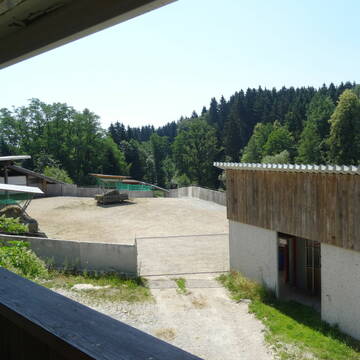
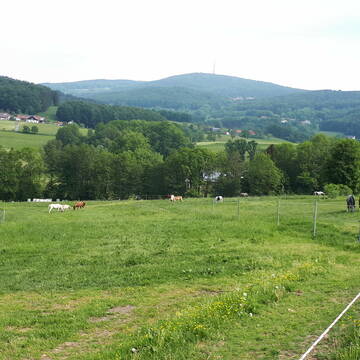
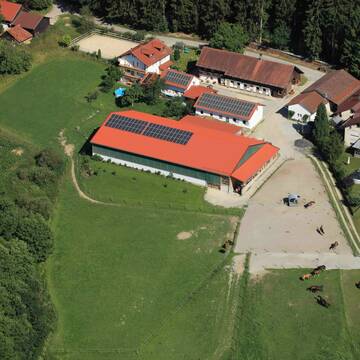
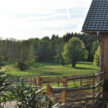
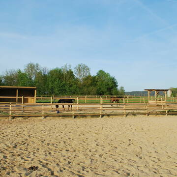
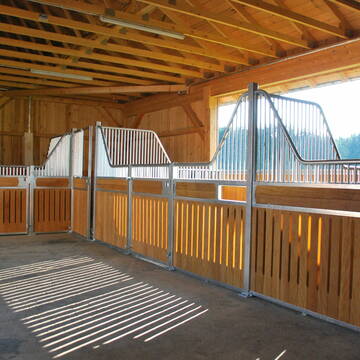
Pferde Bewegungsstall Gut Sommersdorf
Mariaposching
Gut Sommersdorf
@Gut-Sommersdorf
Hunde willkommen
Krankenbox
Notfallboxen
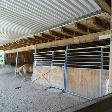
Bewegungsstall
Offenstall
Schauer-Bewegungsstall
11 weitere...
P+
Deprecated: Creation of dynamic property Zend_View_Helper_Ads::$adLink is deprecated in /var/www/stall-frei/htdocs/staging.stall-frei.de/library/Psf/View/Helper/Ads.php on line 108

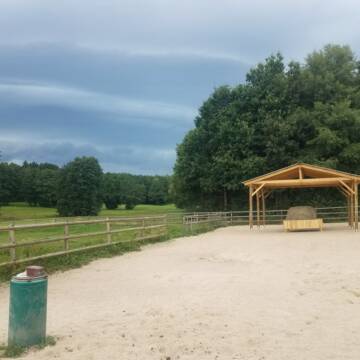
Das Beste für die Hufe
Mechtersen
STALL-FREIde Marketing
@STALL-FREI-Marketing
Hufschmiede und Hufpfleger in Ihrer Nähe
Bewegungsstall, zertifizierter Biobetrieb
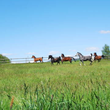
Windorf
Johannes-Orthuber
@Johannes-Orthuber
Freizeitstall
Geländestrecke
Vermieten
Hunde willkommen
Krankenbox
Allergikerstall
Gnadenbrothof
21 weitere...
S
Leider kein Vorschaubild
Leider kein Vorschaubild
Paddockboxen zu vermieten
Schaufling
Emmenegger Walter
@Emmenegger
Freizeitstall
Vermieten
Hunde willkommen
Paddock
Außenbox mit Paddock
9 weitere...
B

Paddockbox/Innenbox/ Offenstall frei!
Schöllnach
Reitanlage Zitzelsberger
@Reitanlage-Zitzelsberger
Freizeitstall
Pferdeausbildung
Vermieten
Hunde willkommen
Laufband
Fohlenaufzucht möglich
Pferdezucht
21 weitere...
P+


Pferdeboxen/Stallplätze/Einstellplätze
Bogen
Steven Schwarz
@BlackHillsideRanch
Freizeitstall
Geländestrecke
Hunde willkommen
Paddock
Gnadenbrothof
Hufrehe geeignet
Innenbox
12 weitere...
P+

Persönlichkeitsentwicklung mit Pferden
Bad Salzuflen
Katja Dors
@Pferdezeiten
Begleite andere auf ihrem Entwicklungsweg und entdecke die transformative Kraft der pferdegestützten Persönlichkeitsentwicklung !
neu
R
Leider kein Vorschaubild
Leider kein Vorschaubild
Biete Offenstallplatz
Zachenberg
Wandelmühle
@Wandelmuehle-Zachenberg
Vermieten
Krankenbox
Longierzirkel/Roundpen
Bewegungsstall
Offenstall
HIT-Aktivstall
9 weitere...
B
Pferdehof Pritzl
Hofkirchen
Pferdehof-Pritzl
@Pferdehof-Pritzl
Freizeitstall
Geländestrecke
Vermieten
Paddock
Reithalle
Außenbox mit Paddock
Außenboxen
12 weitere...
P


Boxen und Offenstall Plätze frei
Beutelsbach
Gabi-Grasse
@GabiGrasse
Freizeitstall
Reitlehrer und -unterricht
Vermieten
Hunde willkommen
Longierzirkel/Roundpen
Allergikerstall
Hufrehe geeignet
14 weitere...
P+
Leider kein Vorschaubild
Leider kein Vorschaubild
Paddockboxen
Bogen
Marion Christ
@Marion-Christ
Freizeitstall
Vermieten
Hunde willkommen
Paddock
Außenbox mit Paddock
Innenbox
11 weitere...
B
Reitanlage Gut Kirchhof
Haibach
Reitanlage-Gut-Kirchhof
@Reitanlage-Gut-Kirchhof
Freizeitstall
Pferdeausbildung
Vermieten
Hunde willkommen
Krankenbox
Außenboxen
Innenbox
16 weitere...
P+
Deprecated: Creation of dynamic property Zend_View::$pageCount is deprecated in /var/www/stall-frei/htdocs/staging.stall-frei.de/library/vendor/shardj/zf1-future/library/Zend/View/Abstract.php on line 308
Deprecated: Creation of dynamic property Zend_View::$itemCountPerPage is deprecated in /var/www/stall-frei/htdocs/staging.stall-frei.de/library/vendor/shardj/zf1-future/library/Zend/View/Abstract.php on line 308
Deprecated: Creation of dynamic property Zend_View::$first is deprecated in /var/www/stall-frei/htdocs/staging.stall-frei.de/library/vendor/shardj/zf1-future/library/Zend/View/Abstract.php on line 308
Deprecated: Creation of dynamic property Zend_View::$current is deprecated in /var/www/stall-frei/htdocs/staging.stall-frei.de/library/vendor/shardj/zf1-future/library/Zend/View/Abstract.php on line 308
Deprecated: Creation of dynamic property Zend_View::$last is deprecated in /var/www/stall-frei/htdocs/staging.stall-frei.de/library/vendor/shardj/zf1-future/library/Zend/View/Abstract.php on line 308
Deprecated: Creation of dynamic property Zend_View::$next is deprecated in /var/www/stall-frei/htdocs/staging.stall-frei.de/library/vendor/shardj/zf1-future/library/Zend/View/Abstract.php on line 308
Deprecated: Creation of dynamic property Zend_View::$pagesInRange is deprecated in /var/www/stall-frei/htdocs/staging.stall-frei.de/library/vendor/shardj/zf1-future/library/Zend/View/Abstract.php on line 308
Deprecated: Creation of dynamic property Zend_View::$firstPageInRange is deprecated in /var/www/stall-frei/htdocs/staging.stall-frei.de/library/vendor/shardj/zf1-future/library/Zend/View/Abstract.php on line 308
Deprecated: Creation of dynamic property Zend_View::$lastPageInRange is deprecated in /var/www/stall-frei/htdocs/staging.stall-frei.de/library/vendor/shardj/zf1-future/library/Zend/View/Abstract.php on line 308
Deprecated: Creation of dynamic property Zend_View::$currentItemCount is deprecated in /var/www/stall-frei/htdocs/staging.stall-frei.de/library/vendor/shardj/zf1-future/library/Zend/View/Abstract.php on line 308
Deprecated: Creation of dynamic property Zend_View::$totalItemCount is deprecated in /var/www/stall-frei/htdocs/staging.stall-frei.de/library/vendor/shardj/zf1-future/library/Zend/View/Abstract.php on line 308
Deprecated: Creation of dynamic property Zend_View::$firstItemNumber is deprecated in /var/www/stall-frei/htdocs/staging.stall-frei.de/library/vendor/shardj/zf1-future/library/Zend/View/Abstract.php on line 308
Deprecated: Creation of dynamic property Zend_View::$lastItemNumber is deprecated in /var/www/stall-frei/htdocs/staging.stall-frei.de/library/vendor/shardj/zf1-future/library/Zend/View/Abstract.php on line 308
Deprecated: Creation of dynamic property Zend_View::$router is deprecated in /var/www/stall-frei/htdocs/staging.stall-frei.de/library/vendor/shardj/zf1-future/library/Zend/View/Abstract.php on line 308
Deprecated: Creation of dynamic property Zend_View::$urlParams is deprecated in /var/www/stall-frei/htdocs/staging.stall-frei.de/library/vendor/shardj/zf1-future/library/Zend/View/Abstract.php on line 308
Deprecated: Creation of dynamic property Zend_View::$showAds is deprecated in /var/www/stall-frei/htdocs/staging.stall-frei.de/library/vendor/shardj/zf1-future/library/Zend/View/Abstract.php on line 308
Deprecated: Creation of dynamic property Zend_View::$objectIds is deprecated in /var/www/stall-frei/htdocs/staging.stall-frei.de/library/vendor/shardj/zf1-future/library/Zend/View/Abstract.php on line 308
Deprecated: Creation of dynamic property Zend_View::$showNavbar is deprecated in /var/www/stall-frei/htdocs/staging.stall-frei.de/library/vendor/shardj/zf1-future/library/Zend/View/Abstract.php on line 308
Deprecated: Creation of dynamic property Zend_View::$showBreadcrumb is deprecated in /var/www/stall-frei/htdocs/staging.stall-frei.de/library/vendor/shardj/zf1-future/library/Zend/View/Abstract.php on line 308
Deprecated: Creation of dynamic property Zend_View::$showFooter is deprecated in /var/www/stall-frei/htdocs/staging.stall-frei.de/library/vendor/shardj/zf1-future/library/Zend/View/Abstract.php on line 308
Deprecated: Creation of dynamic property Zend_View::$showInternalAds is deprecated in /var/www/stall-frei/htdocs/staging.stall-frei.de/library/vendor/shardj/zf1-future/library/Zend/View/Abstract.php on line 308
Deprecated: Creation of dynamic property Zend_View::$blNoContent is deprecated in /var/www/stall-frei/htdocs/staging.stall-frei.de/library/vendor/shardj/zf1-future/library/Zend/View/Abstract.php on line 308
Deprecated: Creation of dynamic property Zend_View::$sMetaDesc is deprecated in /var/www/stall-frei/htdocs/staging.stall-frei.de/library/vendor/shardj/zf1-future/library/Zend/View/Abstract.php on line 308
Deprecated: Creation of dynamic property Zend_View::$useGmaps is deprecated in /var/www/stall-frei/htdocs/staging.stall-frei.de/library/vendor/shardj/zf1-future/library/Zend/View/Abstract.php on line 308
Deprecated: Creation of dynamic property Zend_View::$touches is deprecated in /var/www/stall-frei/htdocs/staging.stall-frei.de/library/vendor/shardj/zf1-future/library/Zend/View/Abstract.php on line 308
Deprecated: Creation of dynamic property Zend_View::$oProject is deprecated in /var/www/stall-frei/htdocs/staging.stall-frei.de/library/vendor/shardj/zf1-future/library/Zend/View/Abstract.php on line 308
Deprecated: Creation of dynamic property Zend_View::$pageHeadline is deprecated in /var/www/stall-frei/htdocs/staging.stall-frei.de/library/vendor/shardj/zf1-future/library/Zend/View/Abstract.php on line 308
Deprecated: Creation of dynamic property Zend_View::$disableLocationField is deprecated in /var/www/stall-frei/htdocs/staging.stall-frei.de/library/vendor/shardj/zf1-future/library/Zend/View/Abstract.php on line 308
Deprecated: Creation of dynamic property Zend_View::$isSearch is deprecated in /var/www/stall-frei/htdocs/staging.stall-frei.de/library/vendor/shardj/zf1-future/library/Zend/View/Abstract.php on line 308
Deprecated: Creation of dynamic property Zend_View::$pageTitle is deprecated in /var/www/stall-frei/htdocs/staging.stall-frei.de/library/vendor/shardj/zf1-future/library/Zend/View/Abstract.php on line 308
Deprecated: Creation of dynamic property Psf_Form_Element_Text::$class is deprecated in /var/www/stall-frei/htdocs/staging.stall-frei.de/library/vendor/shardj/zf1-future/library/Zend/Form/Element.php on line 874
Deprecated: Creation of dynamic property Psf_Form_Element_Text::$size is deprecated in /var/www/stall-frei/htdocs/staging.stall-frei.de/library/vendor/shardj/zf1-future/library/Zend/Form/Element.php on line 874
Deprecated: Creation of dynamic property Psf_Form_Element_Text::$placeholder is deprecated in /var/www/stall-frei/htdocs/staging.stall-frei.de/library/vendor/shardj/zf1-future/library/Zend/Form/Element.php on line 874
Deprecated: Creation of dynamic property Psf_Form_Element_Hidden::$class is deprecated in /var/www/stall-frei/htdocs/staging.stall-frei.de/library/vendor/shardj/zf1-future/library/Zend/Form/Element.php on line 874
Deprecated: Creation of dynamic property Psf_Form_Element_Hidden::$class is deprecated in /var/www/stall-frei/htdocs/staging.stall-frei.de/library/vendor/shardj/zf1-future/library/Zend/Form/Element.php on line 874
Deprecated: Creation of dynamic property Psf_Form_Element_Hidden::$class is deprecated in /var/www/stall-frei/htdocs/staging.stall-frei.de/library/vendor/shardj/zf1-future/library/Zend/Form/Element.php on line 874
Deprecated: Creation of dynamic property Psf_Form_Element_Hidden::$class is deprecated in /var/www/stall-frei/htdocs/staging.stall-frei.de/library/vendor/shardj/zf1-future/library/Zend/Form/Element.php on line 874
Deprecated: Creation of dynamic property Psf_Form_Element_Select::$class is deprecated in /var/www/stall-frei/htdocs/staging.stall-frei.de/library/vendor/shardj/zf1-future/library/Zend/Form/Element.php on line 874
Deprecated: Creation of dynamic property Psf_Form_Element_Select::$class is deprecated in /var/www/stall-frei/htdocs/staging.stall-frei.de/library/vendor/shardj/zf1-future/library/Zend/Form/Element.php on line 874
Deprecated: Creation of dynamic property Psf_Form_Element_Select::$class is deprecated in /var/www/stall-frei/htdocs/staging.stall-frei.de/library/vendor/shardj/zf1-future/library/Zend/Form/Element.php on line 874
Deprecated: Creation of dynamic property Psf_Form_Element_Select::$class is deprecated in /var/www/stall-frei/htdocs/staging.stall-frei.de/library/vendor/shardj/zf1-future/library/Zend/Form/Element.php on line 874
Deprecated: Creation of dynamic property Psf_Form_Element_Text::$class is deprecated in /var/www/stall-frei/htdocs/staging.stall-frei.de/library/vendor/shardj/zf1-future/library/Zend/Form/Element.php on line 874
Deprecated: Creation of dynamic property Psf_Form_Element_Checkbox::$label is deprecated in /var/www/stall-frei/htdocs/staging.stall-frei.de/library/vendor/shardj/zf1-future/library/Zend/Form/Element.php on line 874
Deprecated: Creation of dynamic property Zend_View::$sort is deprecated in /var/www/stall-frei/htdocs/staging.stall-frei.de/library/vendor/shardj/zf1-future/library/Zend/View/Abstract.php on line 308
Deprecated: Creation of dynamic property Zend_View::$searchLocation is deprecated in /var/www/stall-frei/htdocs/staging.stall-frei.de/library/vendor/shardj/zf1-future/library/Zend/View/Abstract.php on line 308
Deprecated: Creation of dynamic property Zend_View::$locationHint is deprecated in /var/www/stall-frei/htdocs/staging.stall-frei.de/library/vendor/shardj/zf1-future/library/Zend/View/Abstract.php on line 308
Psf_GeoCoder_Abstract::getLocation: Sandweg Get Location CachedOrLive
Psf_GeoCoder_Abstract::getCachedOrLive: Sandweg
Psf_GeoCoder_OpenCageData::makeApiRequest: response:
Array
(
[documentation] => https://opencagedata.com/api
[licenses] => Array
(
[0] => Array
(
[name] => see attribution guide
[url] => https://opencagedata.com/credits
)
)
[results] => Array
(
[0] => Array
(
[bounds] => Array
(
[northeast] => Array
(
[lat] => 48.841268
[lng] => 13.0129884
)
[southwest] => Array
(
[lat] => 48.801268
[lng] => 12.9729884
)
)
[components] => Array
(
[ISO_3166-1_alpha-2] => DE
[ISO_3166-1_alpha-3] => DEU
[ISO_3166-2] => Array
(
[0] => DE-BY
)
[_category] => place
[_normalized_city] => Deggendorf
[_type] => hamlet
[continent] => Europe
[country] => Deutschland
[country_code] => de
[county] => Landkreis Deggendorf
[hamlet] => Sandweg
[political_union] => European Union
[postcode] => 94469
[state] => Bayern
[state_code] => BY
[town] => Deggendorf
)
[confidence] => 7
[formatted] => Sandweg, 94469 Deggendorf, Deutschland
[geometry] => Array
(
[lat] => 48.821268
[lng] => 12.9929884
)
)
[1] => Array
(
[bounds] => Array
(
[northeast] => Array
(
[lat] => 49.0394612
[lng] => 12.4256446
)
[southwest] => Array
(
[lat] => 48.9994612
[lng] => 12.3856446
)
)
[components] => Array
(
[ISO_3166-1_alpha-2] => DE
[ISO_3166-1_alpha-3] => DEU
[ISO_3166-2] => Array
(
[0] => DE-BY
)
[_category] => place
[_normalized_city] => Wiesent
[_type] => hamlet
[continent] => Europe
[country] => Deutschland
[country_code] => de
[county] => Landkreis Regensburg
[hamlet] => Sandweg
[political_union] => European Union
[postcode] => 93086
[state] => Bayern
[state_code] => BY
[village] => Wiesent
)
[confidence] => 7
[formatted] => Sandweg, 93086 Wiesent, Deutschland
[geometry] => Array
(
[lat] => 49.0194612
[lng] => 12.4056446
)
)
[2] => Array
(
[bounds] => Array
(
[northeast] => Array
(
[lat] => 49.3029617
[lng] => 8.5802596
)
[southwest] => Array
(
[lat] => 49.3028617
[lng] => 8.5801596
)
)
[components] => Array
(
[ISO_3166-1_alpha-2] => DE
[ISO_3166-1_alpha-3] => DEU
[ISO_3166-2] => Array
(
[0] => DE-BW
)
[_category] => building
[_normalized_city] => Reilingen
[_type] => building
[continent] => Europe
[country] => Deutschland
[country_code] => de
[county] => Rhein-Neckar-Kreis
[isolated_dwelling] => Sandweg
[municipality] => VVG der Stadt Hockenheim
[political_union] => European Union
[postcode] => 68799
[state] => Baden-Württemberg
[state_code] => BW
[village] => Reilingen
)
[confidence] => 10
[formatted] => Sandweg, 68799 Reilingen, Deutschland
[geometry] => Array
(
[lat] => 49.3029117
[lng] => 8.5802096
)
)
[3] => Array
(
[bounds] => Array
(
[northeast] => Array
(
[lat] => 48.6302328
[lng] => 8.1212254
)
[southwest] => Array
(
[lat] => 48.6102328
[lng] => 8.1012254
)
)
[components] => Array
(
[ISO_3166-1_alpha-2] => DE
[ISO_3166-1_alpha-3] => DEU
[ISO_3166-2] => Array
(
[0] => DE-BW
)
[_category] => place
[_normalized_city] => Sasbachwalden
[_type] => hamlet
[continent] => Europe
[country] => Deutschland
[country_code] => de
[county] => Ortenaukreis
[hamlet] => Büchelbach
[municipality] => VVG der Stadt Achern
[neighbourhood] => Sandweg
[political_union] => European Union
[postcode] => 77887
[state] => Baden-Württemberg
[state_code] => BW
[village] => Sasbachwalden
)
[confidence] => 8
[formatted] => Büchelbach, 77887 Sasbachwalden, Deutschland
[geometry] => Array
(
[lat] => 48.6202328
[lng] => 8.1112254
)
)
[4] => Array
(
[bounds] => Array
(
[northeast] => Array
(
[lat] => 50.6776862
[lng] => 11.3079063
)
[southwest] => Array
(
[lat] => 50.6576862
[lng] => 11.2879063
)
)
[components] => Array
(
[ISO_3166-1_alpha-2] => DE
[ISO_3166-1_alpha-3] => DEU
[ISO_3166-2] => Array
(
[0] => DE-TH
)
[_category] => place
[_normalized_city] => Saalfeld/Saale
[_type] => hamlet
[continent] => Europe
[country] => Deutschland
[country_code] => de
[county] => Landkreis Saalfeld-Rudolstadt
[locality] => Sandweg
[political_union] => European Union
[postcode] => 07318
[state] => Thüringen
[state_code] => TH
[town] => Saalfeld/Saale
)
[confidence] => 8
[formatted] => Sandweg, 07318 Saalfeld/Saale, Deutschland
[geometry] => Array
(
[lat] => 50.6676862
[lng] => 11.2979063
)
)
[5] => Array
(
[bounds] => Array
(
[northeast] => Array
(
[lat] => 48.940153
[lng] => 9.1828122
)
[southwest] => Array
(
[lat] => 48.920153
[lng] => 9.1628122
)
)
[components] => Array
(
[ISO_3166-1_alpha-2] => DE
[ISO_3166-1_alpha-3] => DEU
[ISO_3166-2] => Array
(
[0] => DE-BW
)
[_category] => place
[_normalized_city] => Freiberg am Neckar
[_type] => hamlet
[continent] => Europe
[country] => Deutschland
[country_code] => de
[county] => Landkreis Ludwigsburg
[locality] => Sandweg
[municipality] => VVG der Stadt Freiberg am Neckar
[political_union] => European Union
[postcode] => 71691
[state] => Baden-Württemberg
[state_code] => BW
[suburb] => Heutingsheim
[town] => Freiberg am Neckar
)
[confidence] => 8
[formatted] => Sandweg, 71691 Freiberg am Neckar, Deutschland
[geometry] => Array
(
[lat] => 48.930153
[lng] => 9.1728122
)
)
[6] => Array
(
[bounds] => Array
(
[northeast] => Array
(
[lat] => 53.1261023
[lng] => 8.2607481
)
[southwest] => Array
(
[lat] => 53.1231794
[lng] => 8.2563453
)
)
[components] => Array
(
[ISO_3166-1_alpha-2] => DE
[ISO_3166-1_alpha-3] => DEU
[ISO_3166-2] => Array
(
[0] => DE-NI
)
[_category] => road
[_normalized_city] => Oldenburg
[_type] => road
[city] => Oldenburg
[continent] => Europe
[country] => Deutschland
[country_code] => de
[political_union] => European Union
[postcode] => 26135
[road] => Sandweg
[road_type] => residential
[state] => Niedersachsen
[state_code] => NI
[suburb] => Drielaker-Moor
)
[confidence] => 9
[formatted] => Sandweg, 26135 Oldenburg, Deutschland
[geometry] => Array
(
[lat] => 53.1246455
[lng] => 8.2585498
)
)
[7] => Array
(
[bounds] => Array
(
[northeast] => Array
(
[lat] => 50.1791356
[lng] => 9.1175504
)
[southwest] => Array
(
[lat] => 50.1776197
[lng] => 9.1129189
)
)
[components] => Array
(
[ISO_3166-1_alpha-2] => DE
[ISO_3166-1_alpha-3] => DEU
[ISO_3166-2] => Array
(
[0] => DE-HE
)
[_category] => road
[_normalized_city] => Hasselroth
[_type] => road
[continent] => Europe
[country] => Deutschland
[country_code] => de
[county] => Main-Kinzig-Kreis
[municipality] => Hasselroth
[neighbourhood] => Niedermittlau - Bahnhofsiedlung
[political_union] => European Union
[postcode] => 63594
[road] => Sandweg
[road_type] => residential
[state] => Hessen
[state_code] => HE
)
[confidence] => 9
[formatted] => Sandweg, 63594 Hasselroth, Deutschland
[geometry] => Array
(
[lat] => 50.1784049
[lng] => 9.115219
)
)
[8] => Array
(
[bounds] => Array
(
[northeast] => Array
(
[lat] => 50.164134
[lng] => 9.1951555
)
[southwest] => Array
(
[lat] => 50.1628525
[lng] => 9.1940256
)
)
[components] => Array
(
[ISO_3166-1_alpha-2] => DE
[ISO_3166-1_alpha-3] => DEU
[ISO_3166-2] => Array
(
[0] => DE-HE
)
[_category] => road
[_normalized_city] => Großenhausen
[_type] => road
[continent] => Europe
[country] => Deutschland
[country_code] => de
[county] => Main-Kinzig-Kreis
[municipality] => Linsengericht
[political_union] => European Union
[postcode] => 63589
[road] => Sandweg
[road_type] => residential
[state] => Hessen
[state_code] => HE
[village] => Großenhausen
)
[confidence] => 9
[formatted] => Sandweg, 63589 Großenhausen, Deutschland
[geometry] => Array
(
[lat] => 50.1634045
[lng] => 9.194485
)
)
[9] => Array
(
[bounds] => Array
(
[northeast] => Array
(
[lat] => 50.187311
[lng] => 9.1561629
)
[southwest] => Array
(
[lat] => 50.1843535
[lng] => 9.1558911
)
)
[components] => Array
(
[ISO_3166-1_alpha-2] => DE
[ISO_3166-1_alpha-3] => DEU
[ISO_3166-2] => Array
(
[0] => DE-HE
)
[_category] => road
[_normalized_city] => Gelnhausen
[_type] => road
[continent] => Europe
[country] => Deutschland
[country_code] => de
[county] => Main-Kinzig-Kreis
[political_union] => European Union
[postcode] => 63571
[road] => Sandweg
[road_type] => residential
[state] => Hessen
[state_code] => HE
[town] => Gelnhausen
[village] => Hailer
)
[confidence] => 9
[formatted] => Sandweg, 63571 Hailer, Deutschland
[geometry] => Array
(
[lat] => 50.1858252
[lng] => 9.1559353
)
)
)
[status] => Array
(
[code] => 200
[message] => OK
)
[stay_informed] => Array
(
[blog] => https://blog.opencagedata.com
[mastodon] => https://en.osm.town/@opencage
)
[thanks] => For using an OpenCage API
[timestamp] => Array
(
[created_http] => Sun, 08 Feb 2026 12:49:23 GMT
[created_unix] => 1770554963
)
[total_results] => 10
)
Psf_GeoCoder_Abstract::convertLocationResult
{"documentation":"https:\/\/opencagedata.com\/api","licenses":[{"name":"see attribution guide","url":"https:\/\/opencagedata.com\/credits"}],"results":[{"bounds":{"northeast":{"lat":48.841268,"lng":13.0129884},"southwest":{"lat":48.801268,"lng":12.9729884}},"components":{"ISO_3166-1_alpha-2":"DE","ISO_3166-1_alpha-3":"DEU","ISO_3166-2":["DE-BY"],"_category":"place","_normalized_city":"Deggendorf","_type":"hamlet","continent":"Europe","country":"Deutschland","country_code":"de","county":"Landkreis Deggendorf","hamlet":"Sandweg","political_union":"European Union","postcode":"94469","state":"Bayern","state_code":"BY","town":"Deggendorf"},"confidence":7,"formatted":"Sandweg, 94469 Deggendorf, Deutschland","geometry":{"lat":48.821268,"lng":12.9929884}},{"bounds":{"northeast":{"lat":49.0394612,"lng":12.4256446},"southwest":{"lat":48.9994612,"lng":12.3856446}},"components":{"ISO_3166-1_alpha-2":"DE","ISO_3166-1_alpha-3":"DEU","ISO_3166-2":["DE-BY"],"_category":"place","_normalized_city":"Wiesent","_type":"hamlet","continent":"Europe","country":"Deutschland","country_code":"de","county":"Landkreis Regensburg","hamlet":"Sandweg","political_union":"European Union","postcode":"93086","state":"Bayern","state_code":"BY","village":"Wiesent"},"confidence":7,"formatted":"Sandweg, 93086 Wiesent, Deutschland","geometry":{"lat":49.0194612,"lng":12.4056446}},{"bounds":{"northeast":{"lat":49.3029617,"lng":8.5802596},"southwest":{"lat":49.3028617,"lng":8.5801596}},"components":{"ISO_3166-1_alpha-2":"DE","ISO_3166-1_alpha-3":"DEU","ISO_3166-2":["DE-BW"],"_category":"building","_normalized_city":"Reilingen","_type":"building","continent":"Europe","country":"Deutschland","country_code":"de","county":"Rhein-Neckar-Kreis","isolated_dwelling":"Sandweg","municipality":"VVG der Stadt Hockenheim","political_union":"European Union","postcode":"68799","state":"Baden-W\u00fcrttemberg","state_code":"BW","village":"Reilingen"},"confidence":10,"formatted":"Sandweg, 68799 Reilingen, Deutschland","geometry":{"lat":49.3029117,"lng":8.5802096}},{"bounds":{"northeast":{"lat":48.6302328,"lng":8.1212254},"southwest":{"lat":48.6102328,"lng":8.1012254}},"components":{"ISO_3166-1_alpha-2":"DE","ISO_3166-1_alpha-3":"DEU","ISO_3166-2":["DE-BW"],"_category":"place","_normalized_city":"Sasbachwalden","_type":"hamlet","continent":"Europe","country":"Deutschland","country_code":"de","county":"Ortenaukreis","hamlet":"B\u00fcchelbach","municipality":"VVG der Stadt Achern","neighbourhood":"Sandweg","political_union":"European Union","postcode":"77887","state":"Baden-W\u00fcrttemberg","state_code":"BW","village":"Sasbachwalden"},"confidence":8,"formatted":"B\u00fcchelbach, 77887 Sasbachwalden, Deutschland","geometry":{"lat":48.6202328,"lng":8.1112254}},{"bounds":{"northeast":{"lat":50.6776862,"lng":11.3079063},"southwest":{"lat":50.6576862,"lng":11.2879063}},"components":{"ISO_3166-1_alpha-2":"DE","ISO_3166-1_alpha-3":"DEU","ISO_3166-2":["DE-TH"],"_category":"place","_normalized_city":"Saalfeld\/Saale","_type":"hamlet","continent":"Europe","country":"Deutschland","country_code":"de","county":"Landkreis Saalfeld-Rudolstadt","locality":"Sandweg","political_union":"European Union","postcode":"07318","state":"Th\u00fcringen","state_code":"TH","town":"Saalfeld\/Saale"},"confidence":8,"formatted":"Sandweg, 07318 Saalfeld\/Saale, Deutschland","geometry":{"lat":50.6676862,"lng":11.2979063}},{"bounds":{"northeast":{"lat":48.940153,"lng":9.1828122},"southwest":{"lat":48.920153,"lng":9.1628122}},"components":{"ISO_3166-1_alpha-2":"DE","ISO_3166-1_alpha-3":"DEU","ISO_3166-2":["DE-BW"],"_category":"place","_normalized_city":"Freiberg am Neckar","_type":"hamlet","continent":"Europe","country":"Deutschland","country_code":"de","county":"Landkreis Ludwigsburg","locality":"Sandweg","municipality":"VVG der Stadt Freiberg am Neckar","political_union":"European Union","postcode":"71691","state":"Baden-W\u00fcrttemberg","state_code":"BW","suburb":"Heutingsheim","town":"Freiberg am Neckar"},"confidence":8,"formatted":"Sandweg, 71691 Freiberg am Neckar, Deutschland","geometry":{"lat":48.930153,"lng":9.1728122}},{"bounds":{"northeast":{"lat":53.1261023,"lng":8.2607481},"southwest":{"lat":53.1231794,"lng":8.2563453}},"components":{"ISO_3166-1_alpha-2":"DE","ISO_3166-1_alpha-3":"DEU","ISO_3166-2":["DE-NI"],"_category":"road","_normalized_city":"Oldenburg","_type":"road","city":"Oldenburg","continent":"Europe","country":"Deutschland","country_code":"de","political_union":"European Union","postcode":"26135","road":"Sandweg","road_type":"residential","state":"Niedersachsen","state_code":"NI","suburb":"Drielaker-Moor"},"confidence":9,"formatted":"Sandweg, 26135 Oldenburg, Deutschland","geometry":{"lat":53.1246455,"lng":8.2585498}},{"bounds":{"northeast":{"lat":50.1791356,"lng":9.1175504},"southwest":{"lat":50.1776197,"lng":9.1129189}},"components":{"ISO_3166-1_alpha-2":"DE","ISO_3166-1_alpha-3":"DEU","ISO_3166-2":["DE-HE"],"_category":"road","_normalized_city":"Hasselroth","_type":"road","continent":"Europe","country":"Deutschland","country_code":"de","county":"Main-Kinzig-Kreis","municipality":"Hasselroth","neighbourhood":"Niedermittlau - Bahnhofsiedlung","political_union":"European Union","postcode":"63594","road":"Sandweg","road_type":"residential","state":"Hessen","state_code":"HE"},"confidence":9,"formatted":"Sandweg, 63594 Hasselroth, Deutschland","geometry":{"lat":50.1784049,"lng":9.115219}},{"bounds":{"northeast":{"lat":50.164134,"lng":9.1951555},"southwest":{"lat":50.1628525,"lng":9.1940256}},"components":{"ISO_3166-1_alpha-2":"DE","ISO_3166-1_alpha-3":"DEU","ISO_3166-2":["DE-HE"],"_category":"road","_normalized_city":"Gro\u00dfenhausen","_type":"road","continent":"Europe","country":"Deutschland","country_code":"de","county":"Main-Kinzig-Kreis","municipality":"Linsengericht","political_union":"European Union","postcode":"63589","road":"Sandweg","road_type":"residential","state":"Hessen","state_code":"HE","village":"Gro\u00dfenhausen"},"confidence":9,"formatted":"Sandweg, 63589 Gro\u00dfenhausen, Deutschland","geometry":{"lat":50.1634045,"lng":9.194485}},{"bounds":{"northeast":{"lat":50.187311,"lng":9.1561629},"southwest":{"lat":50.1843535,"lng":9.1558911}},"components":{"ISO_3166-1_alpha-2":"DE","ISO_3166-1_alpha-3":"DEU","ISO_3166-2":["DE-HE"],"_category":"road","_normalized_city":"Gelnhausen","_type":"road","continent":"Europe","country":"Deutschland","country_code":"de","county":"Main-Kinzig-Kreis","political_union":"European Union","postcode":"63571","road":"Sandweg","road_type":"residential","state":"Hessen","state_code":"HE","town":"Gelnhausen","village":"Hailer"},"confidence":9,"formatted":"Sandweg, 63571 Hailer, Deutschland","geometry":{"lat":50.1858252,"lng":9.1559353}}],"status":{"code":200,"message":"OK"},"stay_informed":{"blog":"https:\/\/blog.opencagedata.com","mastodon":"https:\/\/en.osm.town\/@opencage"},"thanks":"For using an OpenCage API","timestamp":{"created_http":"Sun, 08 Feb 2026 12:49:23 GMT","created_unix":1770554963},"total_results":10}Array
(
[0] => stdClass Object
(
[bounds] => stdClass Object
(
[northeast] => stdClass Object
(
[lat] => 48.841268
[lng] => 13.0129884
)
[southwest] => stdClass Object
(
[lat] => 48.801268
[lng] => 12.9729884
)
)
[components] => stdClass Object
(
[ISO_3166-1_alpha-2] => DE
[ISO_3166-1_alpha-3] => DEU
[ISO_3166-2] => Array
(
[0] => DE-BY
)
[_category] => place
[_normalized_city] => Deggendorf
[_type] => hamlet
[continent] => Europe
[country] => Deutschland
[country_code] => de
[county] => Landkreis Deggendorf
[hamlet] => Sandweg
[political_union] => European Union
[postcode] => 94469
[state] => Bayern
[state_code] => BY
[town] => Deggendorf
)
[confidence] => 7
[formatted] => Sandweg, 94469 Deggendorf, Deutschland
[geometry] => stdClass Object
(
[lat] => 48.821268
[lng] => 12.9929884
)
)
[1] => stdClass Object
(
[bounds] => stdClass Object
(
[northeast] => stdClass Object
(
[lat] => 49.0394612
[lng] => 12.4256446
)
[southwest] => stdClass Object
(
[lat] => 48.9994612
[lng] => 12.3856446
)
)
[components] => stdClass Object
(
[ISO_3166-1_alpha-2] => DE
[ISO_3166-1_alpha-3] => DEU
[ISO_3166-2] => Array
(
[0] => DE-BY
)
[_category] => place
[_normalized_city] => Wiesent
[_type] => hamlet
[continent] => Europe
[country] => Deutschland
[country_code] => de
[county] => Landkreis Regensburg
[hamlet] => Sandweg
[political_union] => European Union
[postcode] => 93086
[state] => Bayern
[state_code] => BY
[village] => Wiesent
)
[confidence] => 7
[formatted] => Sandweg, 93086 Wiesent, Deutschland
[geometry] => stdClass Object
(
[lat] => 49.0194612
[lng] => 12.4056446
)
)
[2] => stdClass Object
(
[bounds] => stdClass Object
(
[northeast] => stdClass Object
(
[lat] => 49.3029617
[lng] => 8.5802596
)
[southwest] => stdClass Object
(
[lat] => 49.3028617
[lng] => 8.5801596
)
)
[components] => stdClass Object
(
[ISO_3166-1_alpha-2] => DE
[ISO_3166-1_alpha-3] => DEU
[ISO_3166-2] => Array
(
[0] => DE-BW
)
[_category] => building
[_normalized_city] => Reilingen
[_type] => building
[continent] => Europe
[country] => Deutschland
[country_code] => de
[county] => Rhein-Neckar-Kreis
[isolated_dwelling] => Sandweg
[municipality] => VVG der Stadt Hockenheim
[political_union] => European Union
[postcode] => 68799
[state] => Baden-Württemberg
[state_code] => BW
[village] => Reilingen
)
[confidence] => 10
[formatted] => Sandweg, 68799 Reilingen, Deutschland
[geometry] => stdClass Object
(
[lat] => 49.3029117
[lng] => 8.5802096
)
)
[3] => stdClass Object
(
[bounds] => stdClass Object
(
[northeast] => stdClass Object
(
[lat] => 48.6302328
[lng] => 8.1212254
)
[southwest] => stdClass Object
(
[lat] => 48.6102328
[lng] => 8.1012254
)
)
[components] => stdClass Object
(
[ISO_3166-1_alpha-2] => DE
[ISO_3166-1_alpha-3] => DEU
[ISO_3166-2] => Array
(
[0] => DE-BW
)
[_category] => place
[_normalized_city] => Sasbachwalden
[_type] => hamlet
[continent] => Europe
[country] => Deutschland
[country_code] => de
[county] => Ortenaukreis
[hamlet] => Büchelbach
[municipality] => VVG der Stadt Achern
[neighbourhood] => Sandweg
[political_union] => European Union
[postcode] => 77887
[state] => Baden-Württemberg
[state_code] => BW
[village] => Sasbachwalden
)
[confidence] => 8
[formatted] => Büchelbach, 77887 Sasbachwalden, Deutschland
[geometry] => stdClass Object
(
[lat] => 48.6202328
[lng] => 8.1112254
)
)
[4] => stdClass Object
(
[bounds] => stdClass Object
(
[northeast] => stdClass Object
(
[lat] => 50.6776862
[lng] => 11.3079063
)
[southwest] => stdClass Object
(
[lat] => 50.6576862
[lng] => 11.2879063
)
)
[components] => stdClass Object
(
[ISO_3166-1_alpha-2] => DE
[ISO_3166-1_alpha-3] => DEU
[ISO_3166-2] => Array
(
[0] => DE-TH
)
[_category] => place
[_normalized_city] => Saalfeld/Saale
[_type] => hamlet
[continent] => Europe
[country] => Deutschland
[country_code] => de
[county] => Landkreis Saalfeld-Rudolstadt
[locality] => Sandweg
[political_union] => European Union
[postcode] => 07318
[state] => Thüringen
[state_code] => TH
[town] => Saalfeld/Saale
)
[confidence] => 8
[formatted] => Sandweg, 07318 Saalfeld/Saale, Deutschland
[geometry] => stdClass Object
(
[lat] => 50.6676862
[lng] => 11.2979063
)
)
[5] => stdClass Object
(
[bounds] => stdClass Object
(
[northeast] => stdClass Object
(
[lat] => 48.940153
[lng] => 9.1828122
)
[southwest] => stdClass Object
(
[lat] => 48.920153
[lng] => 9.1628122
)
)
[components] => stdClass Object
(
[ISO_3166-1_alpha-2] => DE
[ISO_3166-1_alpha-3] => DEU
[ISO_3166-2] => Array
(
[0] => DE-BW
)
[_category] => place
[_normalized_city] => Freiberg am Neckar
[_type] => hamlet
[continent] => Europe
[country] => Deutschland
[country_code] => de
[county] => Landkreis Ludwigsburg
[locality] => Sandweg
[municipality] => VVG der Stadt Freiberg am Neckar
[political_union] => European Union
[postcode] => 71691
[state] => Baden-Württemberg
[state_code] => BW
[suburb] => Heutingsheim
[town] => Freiberg am Neckar
)
[confidence] => 8
[formatted] => Sandweg, 71691 Freiberg am Neckar, Deutschland
[geometry] => stdClass Object
(
[lat] => 48.930153
[lng] => 9.1728122
)
)
[6] => stdClass Object
(
[bounds] => stdClass Object
(
[northeast] => stdClass Object
(
[lat] => 53.1261023
[lng] => 8.2607481
)
[southwest] => stdClass Object
(
[lat] => 53.1231794
[lng] => 8.2563453
)
)
[components] => stdClass Object
(
[ISO_3166-1_alpha-2] => DE
[ISO_3166-1_alpha-3] => DEU
[ISO_3166-2] => Array
(
[0] => DE-NI
)
[_category] => road
[_normalized_city] => Oldenburg
[_type] => road
[city] => Oldenburg
[continent] => Europe
[country] => Deutschland
[country_code] => de
[political_union] => European Union
[postcode] => 26135
[road] => Sandweg
[road_type] => residential
[state] => Niedersachsen
[state_code] => NI
[suburb] => Drielaker-Moor
)
[confidence] => 9
[formatted] => Sandweg, 26135 Oldenburg, Deutschland
[geometry] => stdClass Object
(
[lat] => 53.1246455
[lng] => 8.2585498
)
)
[7] => stdClass Object
(
[bounds] => stdClass Object
(
[northeast] => stdClass Object
(
[lat] => 50.1791356
[lng] => 9.1175504
)
[southwest] => stdClass Object
(
[lat] => 50.1776197
[lng] => 9.1129189
)
)
[components] => stdClass Object
(
[ISO_3166-1_alpha-2] => DE
[ISO_3166-1_alpha-3] => DEU
[ISO_3166-2] => Array
(
[0] => DE-HE
)
[_category] => road
[_normalized_city] => Hasselroth
[_type] => road
[continent] => Europe
[country] => Deutschland
[country_code] => de
[county] => Main-Kinzig-Kreis
[municipality] => Hasselroth
[neighbourhood] => Niedermittlau - Bahnhofsiedlung
[political_union] => European Union
[postcode] => 63594
[road] => Sandweg
[road_type] => residential
[state] => Hessen
[state_code] => HE
)
[confidence] => 9
[formatted] => Sandweg, 63594 Hasselroth, Deutschland
[geometry] => stdClass Object
(
[lat] => 50.1784049
[lng] => 9.115219
)
)
[8] => stdClass Object
(
[bounds] => stdClass Object
(
[northeast] => stdClass Object
(
[lat] => 50.164134
[lng] => 9.1951555
)
[southwest] => stdClass Object
(
[lat] => 50.1628525
[lng] => 9.1940256
)
)
[components] => stdClass Object
(
[ISO_3166-1_alpha-2] => DE
[ISO_3166-1_alpha-3] => DEU
[ISO_3166-2] => Array
(
[0] => DE-HE
)
[_category] => road
[_normalized_city] => Großenhausen
[_type] => road
[continent] => Europe
[country] => Deutschland
[country_code] => de
[county] => Main-Kinzig-Kreis
[municipality] => Linsengericht
[political_union] => European Union
[postcode] => 63589
[road] => Sandweg
[road_type] => residential
[state] => Hessen
[state_code] => HE
[village] => Großenhausen
)
[confidence] => 9
[formatted] => Sandweg, 63589 Großenhausen, Deutschland
[geometry] => stdClass Object
(
[lat] => 50.1634045
[lng] => 9.194485
)
)
[9] => stdClass Object
(
[bounds] => stdClass Object
(
[northeast] => stdClass Object
(
[lat] => 50.187311
[lng] => 9.1561629
)
[southwest] => stdClass Object
(
[lat] => 50.1843535
[lng] => 9.1558911
)
)
[components] => stdClass Object
(
[ISO_3166-1_alpha-2] => DE
[ISO_3166-1_alpha-3] => DEU
[ISO_3166-2] => Array
(
[0] => DE-HE
)
[_category] => road
[_normalized_city] => Gelnhausen
[_type] => road
[continent] => Europe
[country] => Deutschland
[country_code] => de
[county] => Main-Kinzig-Kreis
[political_union] => European Union
[postcode] => 63571
[road] => Sandweg
[road_type] => residential
[state] => Hessen
[state_code] => HE
[town] => Gelnhausen
[village] => Hailer
)
[confidence] => 9
[formatted] => Sandweg, 63571 Hailer, Deutschland
[geometry] => stdClass Object
(
[lat] => 50.1858252
[lng] => 9.1559353
)
)
)
Psf_GeoCoder_OpenCageData::getKeyMap: 0
stdClass Object
(
    [bounds] => stdClass Object
        (
            [northeast] => stdClass Object
                (
                    [lat] => 48.841268
                    [lng] => 13.0129884
                )

            [southwest] => stdClass Object
                (
                    [lat] => 48.801268
                    [lng] => 12.9729884
                )

        )

    [components] => stdClass Object
        (
            [ISO_3166-1_alpha-2] => DE
            [ISO_3166-1_alpha-3] => DEU
            [ISO_3166-2] => Array
                (
                    [0] => DE-BY
                )

            [_category] => place
            [_normalized_city] => Deggendorf
            [_type] => hamlet
            [continent] => Europe
            [country] => Deutschland
            [country_code] => de
            [county] => Landkreis Deggendorf
            [hamlet] => Sandweg
            [political_union] => European Union
            [postcode] => 94469
            [state] => Bayern
            [state_code] => BY
            [town] => Deggendorf
        )

    [confidence] => 7
    [formatted] => Sandweg, 94469 Deggendorf, Deutschland
    [geometry] => stdClass Object
        (
            [lat] => 48.821268
            [lng] => 12.9929884
        )

)
Psf_GeoCoder_OpenCageData::getCounty: Deggendorf
Psf_GeoCoder_OpenCageData::addMissingData REFETCH!
Array
(
    [address] => Sandweg, 94469 Deggendorf, Deutschland
    [type] => hamlet
    [street] => Sandweg
    [city] => Deggendorf
    [county] => Deggendorf
    [state] => Bayern
    [zip] => 94469
    [country] => Deutschland
    [suburb] =>
    [countrycode] => de
    [latitude] => 48.821268
    [longitude] => 12.9929884
    [accuracy] => 1
    [confidence] => 7
    [bounds] => stdClass Object
        (
            [northeast] => stdClass Object
                (
                    [lat] => 48.841268
                    [lng] => 13.0129884
                )

            [southwest] => stdClass Object
                (
                    [lat] => 48.801268
                    [lng] => 12.9729884
                )

        )

)
reformat!
Array
(
    [address] => Sandweg, 94469 Deggendorf, Deutschland
    [type] => hamlet
    [street] => Sandweg
    [city] => Deggendorf
    [county] => Deggendorf
    [state] => Bayern
    [zip] => 94469
    [country] => Deutschland
    [suburb] =>
    [countrycode] => de
    [latitude] => 48.821268
    [longitude] => 12.9929884
    [accuracy] => 1
    [confidence] => 7
    [bounds] => stdClass Object
        (
            [northeast] => stdClass Object
                (
                    [lat] => 48.841268
                    [lng] => 13.0129884
                )

            [southwest] => stdClass Object
                (
                    [lat] => 48.801268
                    [lng] => 12.9729884
                )

        )

    [place] => Sandweg, 94469 Deggendorf, Bayern
    [hash] => 7fecdad9d361095a1924a19f89c5952c
)
Psf_GeoCoder_OpenCageData::getKeyMap: 1
stdClass Object
(
    [bounds] => stdClass Object
        (
            [northeast] => stdClass Object
                (
                    [lat] => 49.0394612
                    [lng] => 12.4256446
                )

            [southwest] => stdClass Object
                (
                    [lat] => 48.9994612
                    [lng] => 12.3856446
                )

        )

    [components] => stdClass Object
        (
            [ISO_3166-1_alpha-2] => DE
            [ISO_3166-1_alpha-3] => DEU
            [ISO_3166-2] => Array
                (
                    [0] => DE-BY
                )

            [_category] => place
            [_normalized_city] => Wiesent
            [_type] => hamlet
            [continent] => Europe
            [country] => Deutschland
            [country_code] => de
            [county] => Landkreis Regensburg
            [hamlet] => Sandweg
            [political_union] => European Union
            [postcode] => 93086
            [state] => Bayern
            [state_code] => BY
            [village] => Wiesent
        )

    [confidence] => 7
    [formatted] => Sandweg, 93086 Wiesent, Deutschland
    [geometry] => stdClass Object
        (
            [lat] => 49.0194612
            [lng] => 12.4056446
        )

)
Psf_GeoCoder_OpenCageData::getCounty: Regensburg
Psf_GeoCoder_OpenCageData::addMissingData REFETCH!
Array
(
    [address] => Sandweg, 93086 Wiesent, Deutschland
    [type] => hamlet
    [street] => Sandweg
    [city] => Wiesent
    [county] => Regensburg
    [state] => Bayern
    [zip] => 93086
    [country] => Deutschland
    [suburb] =>
    [countrycode] => de
    [latitude] => 49.0194612
    [longitude] => 12.4056446
    [accuracy] => 1
    [confidence] => 7
    [bounds] => stdClass Object
        (
            [northeast] => stdClass Object
                (
                    [lat] => 49.0394612
                    [lng] => 12.4256446
                )

            [southwest] => stdClass Object
                (
                    [lat] => 48.9994612
                    [lng] => 12.3856446
                )

        )

)
reformat!
Array
(
    [address] => Sandweg, 93086 Wiesent, Deutschland
    [type] => hamlet
    [street] => Sandweg
    [city] => Wiesent
    [county] => Regensburg
    [state] => Bayern
    [zip] => 93086
    [country] => Deutschland
    [suburb] =>
    [countrycode] => de
    [latitude] => 49.0194612
    [longitude] => 12.4056446
    [accuracy] => 1
    [confidence] => 7
    [bounds] => stdClass Object
        (
            [northeast] => stdClass Object
                (
                    [lat] => 49.0394612
                    [lng] => 12.4256446
                )

            [southwest] => stdClass Object
                (
                    [lat] => 48.9994612
                    [lng] => 12.3856446
                )

        )

    [place] => Sandweg, 93086 Wiesent, Bayern
    [hash] => 857c7f47664fb34a412de9d5d2ac78a9
)
Psf_GeoCoder_OpenCageData::getKeyMap: 2
stdClass Object
(
    [bounds] => stdClass Object
        (
            [northeast] => stdClass Object
                (
                    [lat] => 49.3029617
                    [lng] => 8.5802596
                )

            [southwest] => stdClass Object
                (
                    [lat] => 49.3028617
                    [lng] => 8.5801596
                )

        )

    [components] => stdClass Object
        (
            [ISO_3166-1_alpha-2] => DE
            [ISO_3166-1_alpha-3] => DEU
            [ISO_3166-2] => Array
                (
                    [0] => DE-BW
                )

            [_category] => building
            [_normalized_city] => Reilingen
            [_type] => building
            [continent] => Europe
            [country] => Deutschland
            [country_code] => de
            [county] => Rhein-Neckar-Kreis
            [isolated_dwelling] => Sandweg
            [municipality] => VVG der Stadt Hockenheim
            [political_union] => European Union
            [postcode] => 68799
            [state] => Baden-Württemberg
            [state_code] => BW
            [village] => Reilingen
        )

    [confidence] => 10
    [formatted] => Sandweg, 68799 Reilingen, Deutschland
    [geometry] => stdClass Object
        (
            [lat] => 49.3029117
            [lng] => 8.5802096
        )

)
Psf_GeoCoder_OpenCageData::getCounty: Rhein-Neckar-Kreis
Psf_GeoCoder_OpenCageData::addMissingData REFETCH!
Array
(
    [address] => Sandweg, 68799 Reilingen, Deutschland
    [type] => building
    [street] =>
    [city] => Reilingen
    [county] => Rhein-Neckar-Kreis
    [state] => Baden-Württemberg
    [zip] => 68799
    [country] => Deutschland
    [suburb] =>
    [countrycode] => de
    [latitude] => 49.3029117
    [longitude] => 8.5802096
    [accuracy] => 1
    [confidence] => 10
    [bounds] => stdClass Object
        (
            [northeast] => stdClass Object
                (
                    [lat] => 49.3029617
                    [lng] => 8.5802596
                )

            [southwest] => stdClass Object
                (
                    [lat] => 49.3028617
                    [lng] => 8.5801596
                )

        )

)
reformat!
Array
(
    [address] => Sandweg, 68799 Reilingen, Deutschland
    [type] => building
    [street] =>
    [city] => Reilingen
    [county] => Rhein-Neckar-Kreis
    [state] => Baden-Württemberg
    [zip] => 68799
    [country] => Deutschland
    [suburb] =>
    [countrycode] => de
    [latitude] => 49.3029117
    [longitude] => 8.5802096
    [accuracy] => 1
    [confidence] => 10
    [bounds] => stdClass Object
        (
            [northeast] => stdClass Object
                (
                    [lat] => 49.3029617
                    [lng] => 8.5802596
                )

            [southwest] => stdClass Object
                (
                    [lat] => 49.3028617
                    [lng] => 8.5801596
                )

        )

    [place] => 68799 Reilingen, Baden-Württemberg
    [hash] => 3b42fa25c6c97d362968d347e259c172
)
Psf_GeoCoder_OpenCageData::getKeyMap: 3
stdClass Object
(
    [bounds] => stdClass Object
        (
            [northeast] => stdClass Object
                (
                    [lat] => 48.6302328
                    [lng] => 8.1212254
                )

            [southwest] => stdClass Object
                (
                    [lat] => 48.6102328
                    [lng] => 8.1012254
                )

        )

    [components] => stdClass Object
        (
            [ISO_3166-1_alpha-2] => DE
            [ISO_3166-1_alpha-3] => DEU
            [ISO_3166-2] => Array
                (
                    [0] => DE-BW
                )

            [_category] => place
            [_normalized_city] => Sasbachwalden
            [_type] => hamlet
            [continent] => Europe
            [country] => Deutschland
            [country_code] => de
            [county] => Ortenaukreis
            [hamlet] => Büchelbach
            [municipality] => VVG der Stadt Achern
            [neighbourhood] => Sandweg
            [political_union] => European Union
            [postcode] => 77887
            [state] => Baden-Württemberg
            [state_code] => BW
            [village] => Sasbachwalden
        )

    [confidence] => 8
    [formatted] => Büchelbach, 77887 Sasbachwalden, Deutschland
    [geometry] => stdClass Object
        (
            [lat] => 48.6202328
            [lng] => 8.1112254
        )

)
Psf_GeoCoder_OpenCageData::getCounty: Ortenaukreis
Psf_GeoCoder_OpenCageData::addMissingData REFETCH!
Array
(
    [address] => Büchelbach, 77887 Sasbachwalden, Deutschland
    [type] => hamlet
    [street] => Büchelbach
    [city] => Sasbachwalden
    [county] => Ortenaukreis
    [state] => Baden-Württemberg
    [zip] => 77887
    [country] => Deutschland
    [suburb] =>
    [countrycode] => de
    [latitude] => 48.6202328
    [longitude] => 8.1112254
    [accuracy] => 1
    [confidence] => 8
    [bounds] => stdClass Object
        (
            [northeast] => stdClass Object
                (
                    [lat] => 48.6302328
                    [lng] => 8.1212254
                )

            [southwest] => stdClass Object
                (
                    [lat] => 48.6102328
                    [lng] => 8.1012254
                )

        )

)
reformat!
Array
(
    [address] => Büchelbach, 77887 Sasbachwalden, Deutschland
    [type] => hamlet
    [street] => Büchelbach
    [city] => Sasbachwalden
    [county] => Ortenaukreis
    [state] => Baden-Württemberg
    [zip] => 77887
    [country] => Deutschland
    [suburb] =>
    [countrycode] => de
    [latitude] => 48.6202328
    [longitude] => 8.1112254
    [accuracy] => 1
    [confidence] => 8
    [bounds] => stdClass Object
        (
            [northeast] => stdClass Object
                (
                    [lat] => 48.6302328
                    [lng] => 8.1212254
                )

            [southwest] => stdClass Object
                (
                    [lat] => 48.6102328
                    [lng] => 8.1012254
                )

        )

    [place] => Büchelbach, 77887 Sasbachwalden, Baden-Württemberg
    [hash] => 13a4b128d05d4b32a4380c647772d36f
)
Psf_GeoCoder_OpenCageData::getKeyMap: 4
stdClass Object
(
    [bounds] => stdClass Object
        (
            [northeast] => stdClass Object
                (
                    [lat] => 50.6776862
                    [lng] => 11.3079063
                )

            [southwest] => stdClass Object
                (
                    [lat] => 50.6576862
                    [lng] => 11.2879063
                )

        )

    [components] => stdClass Object
        (
            [ISO_3166-1_alpha-2] => DE
            [ISO_3166-1_alpha-3] => DEU
            [ISO_3166-2] => Array
                (
                    [0] => DE-TH
                )

            [_category] => place
            [_normalized_city] => Saalfeld/Saale
            [_type] => hamlet
            [continent] => Europe
            [country] => Deutschland
            [country_code] => de
            [county] => Landkreis Saalfeld-Rudolstadt
            [locality] => Sandweg
            [political_union] => European Union
            [postcode] => 07318
            [state] => Thüringen
            [state_code] => TH
            [town] => Saalfeld/Saale
        )

    [confidence] => 8
    [formatted] => Sandweg, 07318 Saalfeld/Saale, Deutschland
    [geometry] => stdClass Object
        (
            [lat] => 50.6676862
            [lng] => 11.2979063
        )

)
Psf_GeoCoder_OpenCageData::getCounty: Saalfeld-Rudolstadt
Psf_GeoCoder_OpenCageData::addMissingData REFETCH!
Array
(
    [address] => Sandweg, 07318 Saalfeld/Saale, Deutschland
    [type] => hamlet
    [street] =>
    [city] => Saalfeld/Saale
    [county] => Saalfeld-Rudolstadt
    [state] => Thüringen
    [zip] => 07318
    [country] => Deutschland
    [suburb] =>
    [countrycode] => de
    [latitude] => 50.6676862
    [longitude] => 11.2979063
    [accuracy] => 1
    [confidence] => 8
    [bounds] => stdClass Object
        (
            [northeast] => stdClass Object
                (
                    [lat] => 50.6776862
                    [lng] => 11.3079063
                )

            [southwest] => stdClass Object
                (
                    [lat] => 50.6576862
                    [lng] => 11.2879063
                )

        )

)
reformat!
Array
(
    [address] => Sandweg, 07318 Saalfeld/Saale, Deutschland
    [type] => hamlet
    [street] =>
    [city] => Saalfeld/Saale
    [county] => Saalfeld-Rudolstadt
    [state] => Thüringen
    [zip] => 07318
    [country] => Deutschland
    [suburb] =>
    [countrycode] => de
    [latitude] => 50.6676862
    [longitude] => 11.2979063
    [accuracy] => 1
    [confidence] => 8
    [bounds] => stdClass Object
        (
            [northeast] => stdClass Object
                (
                    [lat] => 50.6776862
                    [lng] => 11.3079063
                )

            [southwest] => stdClass Object
                (
                    [lat] => 50.6576862
                    [lng] => 11.2879063
                )

        )

    [place] => 07318 Saalfeld/Saale, Thüringen
    [hash] => 3a21c2d062447e060731a4bba346d2e0
)
Psf_GeoCoder_OpenCageData::getKeyMap: 5
stdClass Object
(
    [bounds] => stdClass Object
        (
            [northeast] => stdClass Object
                (
                    [lat] => 48.940153
                    [lng] => 9.1828122
                )

            [southwest] => stdClass Object
                (
                    [lat] => 48.920153
                    [lng] => 9.1628122
                )

        )

    [components] => stdClass Object
        (
            [ISO_3166-1_alpha-2] => DE
            [ISO_3166-1_alpha-3] => DEU
            [ISO_3166-2] => Array
                (
                    [0] => DE-BW
                )

            [_category] => place
            [_normalized_city] => Freiberg am Neckar
            [_type] => hamlet
            [continent] => Europe
            [country] => Deutschland
            [country_code] => de
            [county] => Landkreis Ludwigsburg
            [locality] => Sandweg
            [municipality] => VVG der Stadt Freiberg am Neckar
            [political_union] => European Union
            [postcode] => 71691
            [state] => Baden-Württemberg
            [state_code] => BW
            [suburb] => Heutingsheim
            [town] => Freiberg am Neckar
        )

    [confidence] => 8
    [formatted] => Sandweg, 71691 Freiberg am Neckar, Deutschland
    [geometry] => stdClass Object
        (
            [lat] => 48.930153
            [lng] => 9.1728122
        )

)
Psf_GeoCoder_OpenCageData::getCounty: Ludwigsburg
Psf_GeoCoder_OpenCageData::addMissingData REFETCH!
Array
(
    [address] => Sandweg, 71691 Freiberg am Neckar, Deutschland
    [type] => hamlet
    [street] =>
    [city] => Freiberg am Neckar
    [county] => Ludwigsburg
    [state] => Baden-Württemberg
    [zip] => 71691
    [country] => Deutschland
    [suburb] => Heutingsheim
    [countrycode] => de
    [latitude] => 48.930153
    [longitude] => 9.1728122
    [accuracy] => 1
    [confidence] => 8
    [bounds] => stdClass Object
        (
            [northeast] => stdClass Object
                (
                    [lat] => 48.940153
                    [lng] => 9.1828122
                )

            [southwest] => stdClass Object
                (
                    [lat] => 48.920153
                    [lng] => 9.1628122
                )

        )

)
reformat!
Array
(
    [address] => Sandweg, 71691 Freiberg am Neckar, Deutschland
    [type] => hamlet
    [street] =>
    [city] => Freiberg am Neckar
    [county] => Ludwigsburg
    [state] => Baden-Württemberg
    [zip] => 71691
    [country] => Deutschland
    [suburb] => Heutingsheim
    [countrycode] => de
    [latitude] => 48.930153
    [longitude] => 9.1728122
    [accuracy] => 1
    [confidence] => 8
    [bounds] => stdClass Object
        (
            [northeast] => stdClass Object
                (
                    [lat] => 48.940153
                    [lng] => 9.1828122
                )

            [southwest] => stdClass Object
                (
                    [lat] => 48.920153
                    [lng] => 9.1628122
                )

        )

    [place] => 71691 Freiberg am Neckar, Baden-Württemberg
    [hash] => 44ccf7913c9e69b228df58ae8f9be27f
)
Psf_GeoCoder_OpenCageData::getKeyMap: 6
stdClass Object
(
    [bounds] => stdClass Object
        (
            [northeast] => stdClass Object
                (
                    [lat] => 53.1261023
                    [lng] => 8.2607481
                )

            [southwest] => stdClass Object
                (
                    [lat] => 53.1231794
                    [lng] => 8.2563453
                )

        )

    [components] => stdClass Object
        (
            [ISO_3166-1_alpha-2] => DE
            [ISO_3166-1_alpha-3] => DEU
            [ISO_3166-2] => Array
                (
                    [0] => DE-NI
                )

            [_category] => road
            [_normalized_city] => Oldenburg
            [_type] => road
            [city] => Oldenburg
            [continent] => Europe
            [country] => Deutschland
            [country_code] => de
            [political_union] => European Union
            [postcode] => 26135
            [road] => Sandweg
            [road_type] => residential
            [state] => Niedersachsen
            [state_code] => NI
            [suburb] => Drielaker-Moor
        )

    [confidence] => 9
    [formatted] => Sandweg, 26135 Oldenburg, Deutschland
    [geometry] => stdClass Object
        (
            [lat] => 53.1246455
            [lng] => 8.2585498
        )

)
Psf_GeoCoder_OpenCageData::getCounty: Oldenburg
Psf_GeoCoder_OpenCageData::addMissingData REFETCH!
Array
(
    [address] => Sandweg, 26135 Oldenburg, Deutschland
    [type] => road
    [street] => Sandweg
    [city] => Drielaker-Moor
    [county] => Oldenburg
    [state] => Niedersachsen
    [zip] => 26135
    [country] => Deutschland
    [suburb] => Drielaker-Moor
    [countrycode] => de
    [latitude] => 53.1246455
    [longitude] => 8.2585498
    [accuracy] => 1
    [confidence] => 9
    [bounds] => stdClass Object
        (
            [northeast] => stdClass Object
                (
                    [lat] => 53.1261023
                    [lng] => 8.2607481
                )

            [southwest] => stdClass Object
                (
                    [lat] => 53.1231794
                    [lng] => 8.2563453
                )

        )

)
reformat!
Array
(
    [address] => Sandweg, 26135 Drielaker-Moor
    [type] => road
    [street] => Sandweg
    [city] => Drielaker-Moor
    [county] => Oldenburg
    [state] => Niedersachsen
    [zip] => 26135
    [country] => Deutschland
    [suburb] => Drielaker-Moor
    [countrycode] => de
    [latitude] => 53.1246455
    [longitude] => 8.2585498
    [accuracy] => 1
    [confidence] => 9
    [bounds] => stdClass Object
        (
            [northeast] => stdClass Object
                (
                    [lat] => 53.1261023
                    [lng] => 8.2607481
                )

            [southwest] => stdClass Object
                (
                    [lat] => 53.1231794
                    [lng] => 8.2563453
                )

        )

    [place] => Sandweg, 26135 Drielaker-Moor, Niedersachsen
    [hash] => 4cc3a31996ab9741c829182acc08df42
)
Psf_GeoCoder_OpenCageData::getKeyMap: 7
stdClass Object
(
    [bounds] => stdClass Object
        (
            [northeast] => stdClass Object
                (
                    [lat] => 50.1791356
                    [lng] => 9.1175504
                )

            [southwest] => stdClass Object
                (
                    [lat] => 50.1776197
                    [lng] => 9.1129189
                )

        )

    [components] => stdClass Object
        (
            [ISO_3166-1_alpha-2] => DE
            [ISO_3166-1_alpha-3] => DEU
            [ISO_3166-2] => Array
                (
                    [0] => DE-HE
                )

            [_category] => road
            [_normalized_city] => Hasselroth
            [_type] => road
            [continent] => Europe
            [country] => Deutschland
            [country_code] => de
            [county] => Main-Kinzig-Kreis
            [municipality] => Hasselroth
            [neighbourhood] => Niedermittlau - Bahnhofsiedlung
            [political_union] => European Union
            [postcode] => 63594
            [road] => Sandweg
            [road_type] => residential
            [state] => Hessen
            [state_code] => HE
        )

    [confidence] => 9
    [formatted] => Sandweg, 63594 Hasselroth, Deutschland
    [geometry] => stdClass Object
        (
            [lat] => 50.1784049
            [lng] => 9.115219
        )

)
Psf_GeoCoder_OpenCageData::getCounty: Main-Kinzig-Kreis
Psf_GeoCoder_OpenCageData::addMissingData REFETCH!
Array
(
    [address] => Sandweg, 63594 Hasselroth, Deutschland
    [type] => road
    [street] => Sandweg
    [city] =>
    [county] => Main-Kinzig-Kreis
    [state] => Hessen
    [zip] => 63594
    [country] => Deutschland
    [suburb] =>
    [countrycode] => de
    [latitude] => 50.1784049
    [longitude] => 9.115219
    [accuracy] => 1
    [confidence] => 9
    [bounds] => stdClass Object
        (
            [northeast] => stdClass Object
                (
                    [lat] => 50.1791356
                    [lng] => 9.1175504
                )

            [southwest] => stdClass Object
                (
                    [lat] => 50.1776197
                    [lng] => 9.1129189
                )

        )

)
reformat!
Array
(
    [address] => Sandweg, 63594 Hasselroth, Deutschland
    [type] => road
    [street] => Sandweg
    [city] =>
    [county] => Main-Kinzig-Kreis
    [state] => Hessen
    [zip] => 63594
    [country] => Deutschland
    [suburb] =>
    [countrycode] => de
    [latitude] => 50.1784049
    [longitude] => 9.115219
    [accuracy] => 1
    [confidence] => 9
    [bounds] => stdClass Object
        (
            [northeast] => stdClass Object
                (
                    [lat] => 50.1791356
                    [lng] => 9.1175504
                )

            [southwest] => stdClass Object
                (
                    [lat] => 50.1776197
                    [lng] => 9.1129189
                )

        )

    [place] => Sandweg, 63594 , Hessen
    [hash] => 31120ca095866fa06bf6ca35a8d55a57
)
Psf_GeoCoder_OpenCageData::getKeyMap: 8
stdClass Object
(
    [bounds] => stdClass Object
        (
            [northeast] => stdClass Object
                (
                    [lat] => 50.164134
                    [lng] => 9.1951555
                )

            [southwest] => stdClass Object
                (
                    [lat] => 50.1628525
                    [lng] => 9.1940256
                )

        )

    [components] => stdClass Object
        (
            [ISO_3166-1_alpha-2] => DE
            [ISO_3166-1_alpha-3] => DEU
            [ISO_3166-2] => Array
                (
                    [0] => DE-HE
                )

            [_category] => road
            [_normalized_city] => Großenhausen
            [_type] => road
            [continent] => Europe
            [country] => Deutschland
            [country_code] => de
            [county] => Main-Kinzig-Kreis
            [municipality] => Linsengericht
            [political_union] => European Union
            [postcode] => 63589
            [road] => Sandweg
            [road_type] => residential
            [state] => Hessen
            [state_code] => HE
            [village] => Großenhausen
        )

    [confidence] => 9
    [formatted] => Sandweg, 63589 Großenhausen, Deutschland
    [geometry] => stdClass Object
        (
            [lat] => 50.1634045
            [lng] => 9.194485
        )

)
Psf_GeoCoder_OpenCageData::getCounty: Main-Kinzig-Kreis
Psf_GeoCoder_OpenCageData::addMissingData REFETCH!
Array
(
    [address] => Sandweg, 63589 Großenhausen, Deutschland
    [type] => road
    [street] => Sandweg
    [city] => Großenhausen
    [county] => Main-Kinzig-Kreis
    [state] => Hessen
    [zip] => 63589
    [country] => Deutschland
    [suburb] =>
    [countrycode] => de
    [latitude] => 50.1634045
    [longitude] => 9.194485
    [accuracy] => 1
    [confidence] => 9
    [bounds] => stdClass Object
        (
            [northeast] => stdClass Object
                (
                    [lat] => 50.164134
                    [lng] => 9.1951555
                )

            [southwest] => stdClass Object
                (
                    [lat] => 50.1628525
                    [lng] => 9.1940256
                )

        )

)
reformat!
Array
(
    [address] => Sandweg, 63589 Großenhausen, Deutschland
    [type] => road
    [street] => Sandweg
    [city] => Großenhausen
    [county] => Main-Kinzig-Kreis
    [state] => Hessen
    [zip] => 63589
    [country] => Deutschland
    [suburb] =>
    [countrycode] => de
    [latitude] => 50.1634045
    [longitude] => 9.194485
    [accuracy] => 1
    [confidence] => 9
    [bounds] => stdClass Object
        (
            [northeast] => stdClass Object
                (
                    [lat] => 50.164134
                    [lng] => 9.1951555
                )

            [southwest] => stdClass Object
                (
                    [lat] => 50.1628525
                    [lng] => 9.1940256
                )

        )

    [place] => Sandweg, 63589 Großenhausen, Hessen
    [hash] => 499302e167b66b6c467a7a1a975e5403
)
Psf_GeoCoder_OpenCageData::getKeyMap: 9
stdClass Object
(
    [bounds] => stdClass Object
        (
            [northeast] => stdClass Object
                (
                    [lat] => 50.187311
                    [lng] => 9.1561629
                )

            [southwest] => stdClass Object
                (
                    [lat] => 50.1843535
                    [lng] => 9.1558911
                )

        )

    [components] => stdClass Object
        (
            [ISO_3166-1_alpha-2] => DE
            [ISO_3166-1_alpha-3] => DEU
            [ISO_3166-2] => Array
                (
                    [0] => DE-HE
                )

            [_category] => road
            [_normalized_city] => Gelnhausen
            [_type] => road
            [continent] => Europe
            [country] => Deutschland
            [country_code] => de
            [county] => Main-Kinzig-Kreis
            [political_union] => European Union
            [postcode] => 63571
            [road] => Sandweg
            [road_type] => residential
            [state] => Hessen
            [state_code] => HE
            [town] => Gelnhausen
            [village] => Hailer
        )

    [confidence] => 9
    [formatted] => Sandweg, 63571 Hailer, Deutschland
    [geometry] => stdClass Object
        (
            [lat] => 50.1858252
            [lng] => 9.1559353
        )

)
Psf_GeoCoder_OpenCageData::getCounty: Main-Kinzig-Kreis
Psf_GeoCoder_OpenCageData::addMissingData REFETCH!
Array
(
    [address] => Sandweg, 63571 Hailer, Deutschland
    [type] => road
    [street] => Sandweg
    [city] => Gelnhausen
    [county] => Main-Kinzig-Kreis
    [state] => Hessen
    [zip] => 63571
    [country] => Deutschland
    [suburb] =>
    [countrycode] => de
    [latitude] => 50.1858252
    [longitude] => 9.1559353
    [accuracy] => 1
    [confidence] => 9
    [bounds] => stdClass Object
        (
            [northeast] => stdClass Object
                (
                    [lat] => 50.187311
                    [lng] => 9.1561629
                )

            [southwest] => stdClass Object
                (
                    [lat] => 50.1843535
                    [lng] => 9.1558911
                )

        )

)
reformat!
Array
(
    [address] => Sandweg, 63571 Gelnhausen
    [type] => road
    [street] => Sandweg
    [city] => Gelnhausen
    [county] => Main-Kinzig-Kreis
    [state] => Hessen
    [zip] => 63571
    [country] => Deutschland
    [suburb] =>
    [countrycode] => de
    [latitude] => 50.1858252
    [longitude] => 9.1559353
    [accuracy] => 1
    [confidence] => 9
    [bounds] => stdClass Object
        (
            [northeast] => stdClass Object
                (
                    [lat] => 50.187311
                    [lng] => 9.1561629
                )

            [southwest] => stdClass Object
                (
                    [lat] => 50.1843535
                    [lng] => 9.1558911
                )

        )

    [place] => Sandweg, 63571 Gelnhausen, Hessen
    [hash] => 60d45d2d5df6dd6869306b21ad9d02ce
)
Deprecated: Creation of dynamic property Zend_View::$locationHintStyle is deprecated in /var/www/stall-frei/htdocs/staging.stall-frei.de/library/vendor/shardj/zf1-future/library/Zend/View/Abstract.php on line 308
Deprecated: Creation of dynamic property Zend_View::$adGeoLocation is deprecated in /var/www/stall-frei/htdocs/staging.stall-frei.de/library/vendor/shardj/zf1-future/library/Zend/View/Abstract.php on line 308
Deprecated: Creation of dynamic property Zend_View::$recordCount is deprecated in /var/www/stall-frei/htdocs/staging.stall-frei.de/library/vendor/shardj/zf1-future/library/Zend/View/Abstract.php on line 308
Deprecated: explode(): Passing null to parameter #2 ($string) of type string is deprecated in /var/www/stall-frei/htdocs/staging.stall-frei.de/application/models/SearchAgent.php on line 100
Deprecated: explode(): Passing null to parameter #2 ($string) of type string is deprecated in /var/www/stall-frei/htdocs/staging.stall-frei.de/application/models/SearchAgent.php on line 100
Deprecated: explode(): Passing null to parameter #2 ($string) of type string is deprecated in /var/www/stall-frei/htdocs/staging.stall-frei.de/application/models/SearchAgent.php on line 100
Deprecated: explode(): Passing null to parameter #2 ($string) of type string is deprecated in /var/www/stall-frei/htdocs/staging.stall-frei.de/application/models/SearchAgent.php on line 100
Deprecated: explode(): Passing null to parameter #2 ($string) of type string is deprecated in /var/www/stall-frei/htdocs/staging.stall-frei.de/application/models/SearchAgent.php on line 100
Deprecated: explode(): Passing null to parameter #2 ($string) of type string is deprecated in /var/www/stall-frei/htdocs/staging.stall-frei.de/application/models/SearchAgent.php on line 100
Deprecated: explode(): Passing null to parameter #2 ($string) of type string is deprecated in /var/www/stall-frei/htdocs/staging.stall-frei.de/application/models/SearchAgent.php on line 100
Deprecated: explode(): Passing null to parameter #2 ($string) of type string is deprecated in /var/www/stall-frei/htdocs/staging.stall-frei.de/application/models/SearchAgent.php on line 100
Deprecated: explode(): Passing null to parameter #2 ($string) of type string is deprecated in /var/www/stall-frei/htdocs/staging.stall-frei.de/application/models/SearchAgent.php on line 100
Deprecated: trim(): Passing null to parameter #1 ($string) of type string is deprecated in /var/www/stall-frei/htdocs/staging.stall-frei.de/application/models/Account/Search.php on line 82
Warning: Cannot modify header information - headers already sent by (output started at /var/www/stall-frei/htdocs/staging.stall-frei.de/library/vendor/shardj/zf1-future/library/Zend/View/Abstract.php:308) in /var/www/stall-frei/htdocs/staging.stall-frei.de/application/models/Account/Search.php on line 71
Deprecated: Creation of dynamic property Zend_View::$paginationParams is deprecated in /var/www/stall-frei/htdocs/staging.stall-frei.de/library/vendor/shardj/zf1-future/library/Zend/View/Abstract.php on line 308
Deprecated: Creation of dynamic property Zend_View::$objectPaginator is deprecated in /var/www/stall-frei/htdocs/staging.stall-frei.de/library/vendor/shardj/zf1-future/library/Zend/View/Abstract.php on line 308
Deprecated: Creation of dynamic property Zend_View::$featuredObjects is deprecated in /var/www/stall-frei/htdocs/staging.stall-frei.de/library/vendor/shardj/zf1-future/library/Zend/View/Abstract.php on line 308
Deprecated: Creation of dynamic property Zend_View::$hints is deprecated in /var/www/stall-frei/htdocs/staging.stall-frei.de/library/vendor/shardj/zf1-future/library/Zend/View/Abstract.php on line 308
Deprecated: Creation of dynamic property Zend_View::$attributeHints is deprecated in /var/www/stall-frei/htdocs/staging.stall-frei.de/library/vendor/shardj/zf1-future/library/Zend/View/Abstract.php on line 308
Deprecated: Creation of dynamic property Zend_View::$oSearchForm is deprecated in /var/www/stall-frei/htdocs/staging.stall-frei.de/library/vendor/shardj/zf1-future/library/Zend/View/Abstract.php on line 308