Deprecated: Creation of dynamic property Zend_View::$sMode is deprecated in /var/www/stall-frei/htdocs/staging.stall-frei.de/library/vendor/shardj/zf1-future/library/Zend/View/Abstract.php on line 308
Stallplatz oder Offenstall in Lay
Gesucht wird in "56333 Lay, Deutschland"
6.331 Einträge
Deprecated: Creation of dynamic property Zend_View::$listObjects is deprecated in /var/www/stall-frei/htdocs/staging.stall-frei.de/library/vendor/shardj/zf1-future/library/Zend/View/Abstract.php on line 308
Gesponsort


Deprecated: Creation of dynamic property Zend_View::$listMode is deprecated in /var/www/stall-frei/htdocs/staging.stall-frei.de/library/vendor/shardj/zf1-future/library/Zend/View/Abstract.php on line 308
Deprecated: Creation of dynamic property Zend_View::$renderedObjects is deprecated in /var/www/stall-frei/htdocs/staging.stall-frei.de/library/vendor/shardj/zf1-future/library/Zend/View/Abstract.php on line 308
Deprecated: Creation of dynamic property Zend_View::$index is deprecated in /var/www/stall-frei/htdocs/staging.stall-frei.de/library/vendor/shardj/zf1-future/library/Zend/View/Abstract.php on line 308
Deprecated: Creation of dynamic property Zend_View::$displayMode is deprecated in /var/www/stall-frei/htdocs/staging.stall-frei.de/library/vendor/shardj/zf1-future/library/Zend/View/Abstract.php on line 308
Deprecated: Creation of dynamic property Zend_View::$remarketingIds is deprecated in /var/www/stall-frei/htdocs/staging.stall-frei.de/library/vendor/shardj/zf1-future/library/Zend/View/Abstract.php on line 308
Deprecated: Creation of dynamic property Zend_View::$listItem is deprecated in /var/www/stall-frei/htdocs/staging.stall-frei.de/library/vendor/shardj/zf1-future/library/Zend/View/Abstract.php on line 308
Deprecated: Creation of dynamic property Zend_View::$object is deprecated in /var/www/stall-frei/htdocs/staging.stall-frei.de/library/vendor/shardj/zf1-future/library/Zend/View/Abstract.php on line 308
Deprecated: Creation of dynamic property Zend_View::$attributes is deprecated in /var/www/stall-frei/htdocs/staging.stall-frei.de/library/vendor/shardj/zf1-future/library/Zend/View/Abstract.php on line 308
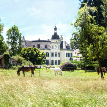


Stalltrakte Selbstversorger - Vollpensionsplätze
Andernach
Reiterhof_Gut_Nettehammer
@Reiterhof_Gut_Nettehammer
Freizeitstall
Geländestrecke
Vermieten
Verpachten
Hunde willkommen
Krankenbox
Gnadenbrothof
Hufrehe geeignet
34 weitere...
P+
Deprecated: Creation of dynamic property Zend_View_Helper_Ads::$adLink is deprecated in /var/www/stall-frei/htdocs/staging.stall-frei.de/library/Psf/View/Helper/Ads.php on line 108

Persönlichkeitsentwicklung mit Pferden
Bad Salzuflen
Katja Dors
@Pferdezeiten
Begleite andere auf ihrem Entwicklungsweg und entdecke die transformative Kraft der pferdegestützten Persönlichkeitsentwicklung !
neu
R

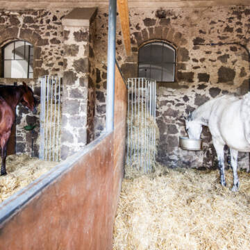
kleiner familiärer PRIVATSTALL mit SERVICE
Siebenborn
HOF-Rheingoldbogen
@HOF-Rheingoldbogen
Freizeitstall
Reitlehrer und -unterricht
Vermieten
Paddock
Parkplatz für Pferdeanhänger
Allergikerstall
11 weitere...
P

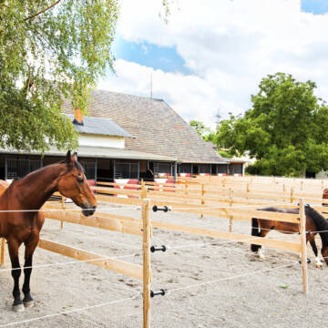
Offenstall
Lonnig
Offenstall
@OffenstallAnna
Freizeitstall
Verpachten
Longierzirkel/Roundpen
Paddock
Gnadenbrothof
Pferdezucht
13 weitere...
P

Offenstall sucht Isländer
Lonnig
melanie-schneider
@melanie-schneider
Geländestrecke
Reithalle
Weide
Allergikerstall
bedampftes/gewaschenes Heu
Laufstall
Offenstall
3 weitere...
P

Box frei, Paddock Box Frei
Saffig
Claudia
@Zilligen
FN-Mitglied
Freizeitstall
Vermieten
Krankenbox
Paddock
Außenbox mit Paddock
Außenboxen
14 weitere...
P

Aktivstall, Paddocktrail, Diätstall, Offenstall
Lonnig
Happy Horse Trail
@HappyHorseTrail
Krankenbox
Paddock
Allergikerstall
bedampftes/gewaschenes Heu
Bewegungsstall
Offenstall
Halbpension
Vollpension
11 weitere...
P
Leider kein Vorschaubild
Leider kein Vorschaubild
Boxen in Vollpension und Plätze im Aktivstall fr...
Lahnstein
Müller
@GestuetMueller
FN-Mitglied
Freizeitstall
Führanlage
Hunde willkommen
bedampftes/gewaschenes Heu
Außenbox mit Paddock
Außenboxen
17 weitere...
B

Offenstall/Paddockbox für Pony oder Kleinpferd
Glashütten
Tatjana Bommersheim
@TatjanaBommersheim
Wir haben ab dem 1.04.26 eine Platz in einem unsere Offenställe (Wallach oder Stute)und eine unserer Paddockboxen (Wallach oder S
neu
R


Boxen zu vermieten
Waldbreitbach
Jaqueline-Salz
@Jaqueline-Salz
FN-Mitglied
Freizeitstall
Longierzirkel/Roundpen
Paddock
Hufrehe geeignet
Außenbox mit Paddock
Innenbox
13 weitere...
S
Leider kein Vorschaubild
Leider kein Vorschaubild
Paddockbox in Offenstall
Kobern-Gondorf
Sofia
@SofiaLu
Paddock
Reitplatz (z.B. Dressur, Springen, Reining)
Außenbox mit Paddock
Offenstall
Selbstversorgung
2 weitere...
B
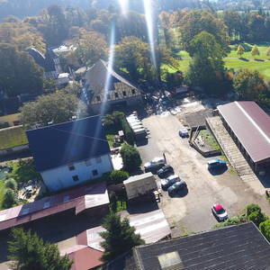
Hofgut Denzerheide
Bad Ems
Heinrich Dehe
@Heinrich_Dehe
Freizeitstall
Geländestrecke
Hunde willkommen
Longierzirkel/Roundpen
Gnadenbrothof
Hengsthaltung möglich
Außenbox mit Paddock
Außenboxen
17 weitere...
P
Deprecated: Creation of dynamic property Zend_View::$pageCount is deprecated in /var/www/stall-frei/htdocs/staging.stall-frei.de/library/vendor/shardj/zf1-future/library/Zend/View/Abstract.php on line 308
Deprecated: Creation of dynamic property Zend_View::$itemCountPerPage is deprecated in /var/www/stall-frei/htdocs/staging.stall-frei.de/library/vendor/shardj/zf1-future/library/Zend/View/Abstract.php on line 308
Deprecated: Creation of dynamic property Zend_View::$first is deprecated in /var/www/stall-frei/htdocs/staging.stall-frei.de/library/vendor/shardj/zf1-future/library/Zend/View/Abstract.php on line 308
Deprecated: Creation of dynamic property Zend_View::$current is deprecated in /var/www/stall-frei/htdocs/staging.stall-frei.de/library/vendor/shardj/zf1-future/library/Zend/View/Abstract.php on line 308
Deprecated: Creation of dynamic property Zend_View::$last is deprecated in /var/www/stall-frei/htdocs/staging.stall-frei.de/library/vendor/shardj/zf1-future/library/Zend/View/Abstract.php on line 308
Deprecated: Creation of dynamic property Zend_View::$next is deprecated in /var/www/stall-frei/htdocs/staging.stall-frei.de/library/vendor/shardj/zf1-future/library/Zend/View/Abstract.php on line 308
Deprecated: Creation of dynamic property Zend_View::$pagesInRange is deprecated in /var/www/stall-frei/htdocs/staging.stall-frei.de/library/vendor/shardj/zf1-future/library/Zend/View/Abstract.php on line 308
Deprecated: Creation of dynamic property Zend_View::$firstPageInRange is deprecated in /var/www/stall-frei/htdocs/staging.stall-frei.de/library/vendor/shardj/zf1-future/library/Zend/View/Abstract.php on line 308
Deprecated: Creation of dynamic property Zend_View::$lastPageInRange is deprecated in /var/www/stall-frei/htdocs/staging.stall-frei.de/library/vendor/shardj/zf1-future/library/Zend/View/Abstract.php on line 308
Deprecated: Creation of dynamic property Zend_View::$currentItemCount is deprecated in /var/www/stall-frei/htdocs/staging.stall-frei.de/library/vendor/shardj/zf1-future/library/Zend/View/Abstract.php on line 308
Deprecated: Creation of dynamic property Zend_View::$totalItemCount is deprecated in /var/www/stall-frei/htdocs/staging.stall-frei.de/library/vendor/shardj/zf1-future/library/Zend/View/Abstract.php on line 308
Deprecated: Creation of dynamic property Zend_View::$firstItemNumber is deprecated in /var/www/stall-frei/htdocs/staging.stall-frei.de/library/vendor/shardj/zf1-future/library/Zend/View/Abstract.php on line 308
Deprecated: Creation of dynamic property Zend_View::$lastItemNumber is deprecated in /var/www/stall-frei/htdocs/staging.stall-frei.de/library/vendor/shardj/zf1-future/library/Zend/View/Abstract.php on line 308
Deprecated: Creation of dynamic property Zend_View::$router is deprecated in /var/www/stall-frei/htdocs/staging.stall-frei.de/library/vendor/shardj/zf1-future/library/Zend/View/Abstract.php on line 308
Deprecated: Creation of dynamic property Zend_View::$urlParams is deprecated in /var/www/stall-frei/htdocs/staging.stall-frei.de/library/vendor/shardj/zf1-future/library/Zend/View/Abstract.php on line 308
Deprecated: Creation of dynamic property Zend_View::$showAds is deprecated in /var/www/stall-frei/htdocs/staging.stall-frei.de/library/vendor/shardj/zf1-future/library/Zend/View/Abstract.php on line 308
Deprecated: Creation of dynamic property Zend_View::$objectIds is deprecated in /var/www/stall-frei/htdocs/staging.stall-frei.de/library/vendor/shardj/zf1-future/library/Zend/View/Abstract.php on line 308
Deprecated: Creation of dynamic property Zend_View::$showNavbar is deprecated in /var/www/stall-frei/htdocs/staging.stall-frei.de/library/vendor/shardj/zf1-future/library/Zend/View/Abstract.php on line 308
Deprecated: Creation of dynamic property Zend_View::$showBreadcrumb is deprecated in /var/www/stall-frei/htdocs/staging.stall-frei.de/library/vendor/shardj/zf1-future/library/Zend/View/Abstract.php on line 308
Deprecated: Creation of dynamic property Zend_View::$showFooter is deprecated in /var/www/stall-frei/htdocs/staging.stall-frei.de/library/vendor/shardj/zf1-future/library/Zend/View/Abstract.php on line 308
Deprecated: Creation of dynamic property Zend_View::$showInternalAds is deprecated in /var/www/stall-frei/htdocs/staging.stall-frei.de/library/vendor/shardj/zf1-future/library/Zend/View/Abstract.php on line 308
Deprecated: Creation of dynamic property Zend_View::$blNoContent is deprecated in /var/www/stall-frei/htdocs/staging.stall-frei.de/library/vendor/shardj/zf1-future/library/Zend/View/Abstract.php on line 308
Deprecated: Creation of dynamic property Zend_View::$sMetaDesc is deprecated in /var/www/stall-frei/htdocs/staging.stall-frei.de/library/vendor/shardj/zf1-future/library/Zend/View/Abstract.php on line 308
Deprecated: Creation of dynamic property Zend_View::$useGmaps is deprecated in /var/www/stall-frei/htdocs/staging.stall-frei.de/library/vendor/shardj/zf1-future/library/Zend/View/Abstract.php on line 308
Deprecated: Creation of dynamic property Zend_View::$touches is deprecated in /var/www/stall-frei/htdocs/staging.stall-frei.de/library/vendor/shardj/zf1-future/library/Zend/View/Abstract.php on line 308
Deprecated: Creation of dynamic property Zend_View::$oProject is deprecated in /var/www/stall-frei/htdocs/staging.stall-frei.de/library/vendor/shardj/zf1-future/library/Zend/View/Abstract.php on line 308
Deprecated: Creation of dynamic property Zend_View::$pageHeadline is deprecated in /var/www/stall-frei/htdocs/staging.stall-frei.de/library/vendor/shardj/zf1-future/library/Zend/View/Abstract.php on line 308
Deprecated: Creation of dynamic property Zend_View::$disableLocationField is deprecated in /var/www/stall-frei/htdocs/staging.stall-frei.de/library/vendor/shardj/zf1-future/library/Zend/View/Abstract.php on line 308
Deprecated: Creation of dynamic property Zend_View::$isSearch is deprecated in /var/www/stall-frei/htdocs/staging.stall-frei.de/library/vendor/shardj/zf1-future/library/Zend/View/Abstract.php on line 308
Deprecated: Creation of dynamic property Zend_View::$pageTitle is deprecated in /var/www/stall-frei/htdocs/staging.stall-frei.de/library/vendor/shardj/zf1-future/library/Zend/View/Abstract.php on line 308
Deprecated: Creation of dynamic property Psf_Form_Element_Text::$class is deprecated in /var/www/stall-frei/htdocs/staging.stall-frei.de/library/vendor/shardj/zf1-future/library/Zend/Form/Element.php on line 874
Deprecated: Creation of dynamic property Psf_Form_Element_Text::$size is deprecated in /var/www/stall-frei/htdocs/staging.stall-frei.de/library/vendor/shardj/zf1-future/library/Zend/Form/Element.php on line 874
Deprecated: Creation of dynamic property Psf_Form_Element_Text::$placeholder is deprecated in /var/www/stall-frei/htdocs/staging.stall-frei.de/library/vendor/shardj/zf1-future/library/Zend/Form/Element.php on line 874
Deprecated: Creation of dynamic property Psf_Form_Element_Hidden::$class is deprecated in /var/www/stall-frei/htdocs/staging.stall-frei.de/library/vendor/shardj/zf1-future/library/Zend/Form/Element.php on line 874
Deprecated: Creation of dynamic property Psf_Form_Element_Hidden::$class is deprecated in /var/www/stall-frei/htdocs/staging.stall-frei.de/library/vendor/shardj/zf1-future/library/Zend/Form/Element.php on line 874
Deprecated: Creation of dynamic property Psf_Form_Element_Hidden::$class is deprecated in /var/www/stall-frei/htdocs/staging.stall-frei.de/library/vendor/shardj/zf1-future/library/Zend/Form/Element.php on line 874
Deprecated: Creation of dynamic property Psf_Form_Element_Hidden::$class is deprecated in /var/www/stall-frei/htdocs/staging.stall-frei.de/library/vendor/shardj/zf1-future/library/Zend/Form/Element.php on line 874
Deprecated: Creation of dynamic property Psf_Form_Element_Select::$class is deprecated in /var/www/stall-frei/htdocs/staging.stall-frei.de/library/vendor/shardj/zf1-future/library/Zend/Form/Element.php on line 874
Deprecated: Creation of dynamic property Psf_Form_Element_Select::$class is deprecated in /var/www/stall-frei/htdocs/staging.stall-frei.de/library/vendor/shardj/zf1-future/library/Zend/Form/Element.php on line 874
Deprecated: Creation of dynamic property Psf_Form_Element_Select::$class is deprecated in /var/www/stall-frei/htdocs/staging.stall-frei.de/library/vendor/shardj/zf1-future/library/Zend/Form/Element.php on line 874
Deprecated: Creation of dynamic property Psf_Form_Element_Select::$class is deprecated in /var/www/stall-frei/htdocs/staging.stall-frei.de/library/vendor/shardj/zf1-future/library/Zend/Form/Element.php on line 874
Deprecated: Creation of dynamic property Psf_Form_Element_Text::$class is deprecated in /var/www/stall-frei/htdocs/staging.stall-frei.de/library/vendor/shardj/zf1-future/library/Zend/Form/Element.php on line 874
Deprecated: Creation of dynamic property Psf_Form_Element_Checkbox::$label is deprecated in /var/www/stall-frei/htdocs/staging.stall-frei.de/library/vendor/shardj/zf1-future/library/Zend/Form/Element.php on line 874
Deprecated: Creation of dynamic property Zend_View::$sort is deprecated in /var/www/stall-frei/htdocs/staging.stall-frei.de/library/vendor/shardj/zf1-future/library/Zend/View/Abstract.php on line 308
Deprecated: Creation of dynamic property Zend_View::$searchLocation is deprecated in /var/www/stall-frei/htdocs/staging.stall-frei.de/library/vendor/shardj/zf1-future/library/Zend/View/Abstract.php on line 308
Deprecated: Creation of dynamic property Zend_View::$locationHint is deprecated in /var/www/stall-frei/htdocs/staging.stall-frei.de/library/vendor/shardj/zf1-future/library/Zend/View/Abstract.php on line 308
Psf_GeoCoder_Abstract::getLocation: Lay Get Location CachedOrLive
Psf_GeoCoder_Abstract::getCachedOrLive: Lay
Psf_GeoCoder_OpenCageData::makeApiRequest: response:
Array
(
[documentation] => https://opencagedata.com/api
[licenses] => Array
(
[0] => Array
(
[name] => see attribution guide
[url] => https://opencagedata.com/credits
)
)
[results] => Array
(
[0] => Array
(
[bounds] => Array
(
[northeast] => Array
(
[lat] => 50.341729
[lng] => 7.5616577
)
[southwest] => Array
(
[lat] => 50.301729
[lng] => 7.5216577
)
)
[components] => Array
(
[ISO_3166-1_alpha-2] => DE
[ISO_3166-1_alpha-3] => DEU
[ISO_3166-2] => Array
(
[0] => DE-RP
)
[_category] => place
[_normalized_city] => Koblenz
[_type] => village
[city] => Koblenz
[continent] => Europe
[country] => Deutschland
[country_code] => de
[political_union] => European Union
[postcode] => 56333
[state] => Rheinland-Pfalz
[state_code] => RP
[village] => Lay
)
[confidence] => 7
[formatted] => 56333 Lay, Deutschland
[geometry] => Array
(
[lat] => 50.321729
[lng] => 7.5416577
)
)
[1] => Array
(
[bounds] => Array
(
[northeast] => Array
(
[lat] => 49.1698063
[lng] => 11.294708
)
[southwest] => Array
(
[lat] => 49.1298063
[lng] => 11.254708
)
)
[components] => Array
(
[ISO_3166-1_alpha-2] => DE
[ISO_3166-1_alpha-3] => DEU
[ISO_3166-2] => Array
(
[0] => DE-BY
)
[_category] => place
[_normalized_city] => Hilpoltstein
[_type] => hamlet
[continent] => Europe
[country] => Deutschland
[country_code] => de
[county] => Landkreis Roth
[hamlet] => Lay
[political_union] => European Union
[postcode] => 91161
[state] => Bayern
[state_code] => BY
[town] => Hilpoltstein
)
[confidence] => 7
[formatted] => Lay, 91161 Hilpoltstein, Deutschland
[geometry] => Array
(
[lat] => 49.1498063
[lng] => 11.274708
)
)
[2] => Array
(
[bounds] => Array
(
[northeast] => Array
(
[lat] => 50.3300695
[lng] => 7.5616367
)
[southwest] => Array
(
[lat] => 50.306838
[lng] => 7.5173137
)
)
[components] => Array
(
[ISO_3166-1_alpha-2] => DE
[ISO_3166-1_alpha-3] => DEU
[ISO_3166-2] => Array
(
[0] => DE-RP
)
[_category] => place
[_normalized_city] => Koblenz
[_type] => neighbourhood
[city] => Koblenz
[city_district] => Lay
[continent] => Europe
[country] => Deutschland
[country_code] => de
[political_union] => European Union
[state] => Rheinland-Pfalz
[state_code] => RP
)
[confidence] => 7
[formatted] => Lay, Koblenz, Rheinland-Pfalz, Deutschland
[geometry] => Array
(
[lat] => 50.318407
[lng] => 7.5364781
)
)
[3] => Array
(
[bounds] => Array
(
[northeast] => Array
(
[lat] => 49.1525248
[lng] => 11.2764901
)
[southwest] => Array
(
[lat] => 49.1502424
[lng] => 11.2747162
)
)
[components] => Array
(
[ISO_3166-1_alpha-2] => DE
[ISO_3166-1_alpha-3] => DEU
[ISO_3166-2] => Array
(
[0] => DE-BY
)
[_category] => road
[_normalized_city] => Hilpoltstein
[_type] => road
[continent] => Europe
[country] => Deutschland
[country_code] => de
[county] => Landkreis Roth
[hamlet] => Lay
[political_union] => European Union
[postcode] => 91161
[road] => Lay
[road_type] => tertiary
[state] => Bayern
[state_code] => BY
[town] => Hilpoltstein
)
[confidence] => 9
[formatted] => Lay, 91161 Hilpoltstein, Deutschland
[geometry] => Array
(
[lat] => 49.1513918
[lng] => 11.2755913
)
)
[4] => Array
(
[components] => Array
(
[ISO_3166-1_alpha-2] => FR
[ISO_3166-1_alpha-3] => FRA
[ISO_3166-2] => Array
(
[0] => FR-PDL
[1] => FR-49
)
[_category] => road
[_normalized_city] => Rives-du-Loir-en-Anjou
[_type] => road
[city] => Rives-du-Loir-en-Anjou
[continent] => Europe
[country] => France
[country_code] => fr
[county] => Maine-et-Loire
[local_authority] => Angers Loire Métropole
[political_union] => European Union
[postcode] => 49140
[road] => Laie des Landes
[state] => Pays de la Loire
[state_code] => PDL
)
[confidence] => 2
[formatted] => Laie des Landes, 49140 Rives-du-Loir-en-Anjou, France
[geometry] => Array
(
[lat] => 47.583089
[lng] => -0.416435
)
)
[5] => Array
(
[components] => Array
(
[ISO_3166-1_alpha-2] => FR
[ISO_3166-1_alpha-3] => FRA
[ISO_3166-2] => Array
(
[0] => FR-ARA
[1] => FR-38
)
[_category] => road
[_normalized_city] => Saint-Clair-de-la-Tour
[_type] => road
[city] => Saint-Clair-de-la-Tour
[continent] => Europe
[country] => France
[country_code] => fr
[county] => Isère
[local_authority] => Les Vals du Dauphiné
[political_union] => European Union
[postcode] => 38110
[road] => Route de Laye
[state] => Auvergne-Rhône-Alpes
[state_code] => ARA
)
[confidence] => 2
[formatted] => Route de Laye, 38110 Saint-Clair-de-la-Tour, France
[geometry] => Array
(
[lat] => 45.569695
[lng] => 5.499482
)
)
[6] => Array
(
[components] => Array
(
[ISO_3166-1_alpha-2] => FR
[ISO_3166-1_alpha-3] => FRA
[ISO_3166-2] => Array
(
[0] => FR-BFC
[1] => FR-71
)
[_category] => road
[_normalized_city] => Chauffailles
[_type] => road
[city] => Chauffailles
[continent] => Europe
[country] => France
[country_code] => fr
[county] => Saône-et-Loire
[local_authority] => Communauté de communes Brionnais Sud Bourgogne
[political_union] => European Union
[postcode] => 71170
[road] => route de laye
[state] => Bourgogne-Franche-Comté
[state_code] => BFC
)
[confidence] => 2
[formatted] => route de laye, 71170 Chauffailles, France
[geometry] => Array
(
[lat] => 46.211247
[lng] => 4.343578
)
)
[7] => Array
(
[components] => Array
(
[ISO_3166-1_alpha-2] => FR
[ISO_3166-1_alpha-3] => FRA
[ISO_3166-2] => Array
(
[0] => FR-BFC
[1] => FR-71
)
[_category] => road
[_normalized_city] => Pierre-de-Bresse
[_type] => road
[city] => Pierre-de-Bresse
[continent] => Europe
[country] => France
[country_code] => fr
[county] => Saône-et-Loire
[local_authority] => Bresse Nord Intercom
[political_union] => European Union
[postcode] => 71270
[road] => Route de Lays
[state] => Bourgogne-Franche-Comté
[state_code] => BFC
)
[confidence] => 2
[formatted] => Route de Lays, 71270 Pierre-de-Bresse, France
[geometry] => Array
(
[lat] => 46.891234
[lng] => 5.258249
)
)
[8] => Array
(
[components] => Array
(
[ISO_3166-1_alpha-2] => FR
[ISO_3166-1_alpha-3] => FRA
[ISO_3166-2] => Array
(
[0] => FR-OCC
[1] => FR-82
)
[_category] => road
[_normalized_city] => Moissac
[_type] => road
[city] => Moissac
[continent] => Europe
[country] => France
[country_code] => fr
[county] => Tarn-et-Garonne
[local_authority] => Communauté de communes Terres des Confluences
[political_union] => European Union
[postcode] => 82200
[road] => Chemin de Laye
[state] => Occitanie
[state_code] => OCC
)
[confidence] => 2
[formatted] => Chemin de Laye, 82200 Moissac, France
[geometry] => Array
(
[lat] => 44.138617
[lng] => 1.098705
)
)
[9] => Array
(
[components] => Array
(
[ISO_3166-1_alpha-2] => FR
[ISO_3166-1_alpha-3] => FRA
[ISO_3166-2] => Array
(
[0] => FR-ARA
[1] => FR-26
)
[_category] => road
[_normalized_city] => Saint-Marcel-lès-Valence
[_type] => road
[city] => Saint-Marcel-lès-Valence
[continent] => Europe
[country] => France
[country_code] => fr
[county] => Drôme
[local_authority] => Valence Romans Agglo
[political_union] => European Union
[postcode] => 26320
[road] => Chemin de Laye
[state] => Auvergne-Rhône-Alpes
[state_code] => ARA
)
[confidence] => 2
[formatted] => Chemin de Laye, 26320 Saint-Marcel-lès-Valence, France
[geometry] => Array
(
[lat] => 44.959545
[lng] => 4.933933
)
)
)
[status] => Array
(
[code] => 200
[message] => OK
)
[stay_informed] => Array
(
[blog] => https://blog.opencagedata.com
[mastodon] => https://en.osm.town/@opencage
)
[thanks] => For using an OpenCage API
[timestamp] => Array
(
[created_http] => Sun, 08 Feb 2026 14:27:04 GMT
[created_unix] => 1770560824
)
[total_results] => 10
)
Psf_GeoCoder_Abstract::convertLocationResult
{"documentation":"https:\/\/opencagedata.com\/api","licenses":[{"name":"see attribution guide","url":"https:\/\/opencagedata.com\/credits"}],"results":[{"bounds":{"northeast":{"lat":50.341729,"lng":7.5616577},"southwest":{"lat":50.301729,"lng":7.5216577}},"components":{"ISO_3166-1_alpha-2":"DE","ISO_3166-1_alpha-3":"DEU","ISO_3166-2":["DE-RP"],"_category":"place","_normalized_city":"Koblenz","_type":"village","city":"Koblenz","continent":"Europe","country":"Deutschland","country_code":"de","political_union":"European Union","postcode":"56333","state":"Rheinland-Pfalz","state_code":"RP","village":"Lay"},"confidence":7,"formatted":"56333 Lay, Deutschland","geometry":{"lat":50.321729,"lng":7.5416577}},{"bounds":{"northeast":{"lat":49.1698063,"lng":11.294708},"southwest":{"lat":49.1298063,"lng":11.254708}},"components":{"ISO_3166-1_alpha-2":"DE","ISO_3166-1_alpha-3":"DEU","ISO_3166-2":["DE-BY"],"_category":"place","_normalized_city":"Hilpoltstein","_type":"hamlet","continent":"Europe","country":"Deutschland","country_code":"de","county":"Landkreis Roth","hamlet":"Lay","political_union":"European Union","postcode":"91161","state":"Bayern","state_code":"BY","town":"Hilpoltstein"},"confidence":7,"formatted":"Lay, 91161 Hilpoltstein, Deutschland","geometry":{"lat":49.1498063,"lng":11.274708}},{"bounds":{"northeast":{"lat":50.3300695,"lng":7.5616367},"southwest":{"lat":50.306838,"lng":7.5173137}},"components":{"ISO_3166-1_alpha-2":"DE","ISO_3166-1_alpha-3":"DEU","ISO_3166-2":["DE-RP"],"_category":"place","_normalized_city":"Koblenz","_type":"neighbourhood","city":"Koblenz","city_district":"Lay","continent":"Europe","country":"Deutschland","country_code":"de","political_union":"European Union","state":"Rheinland-Pfalz","state_code":"RP"},"confidence":7,"formatted":"Lay, Koblenz, Rheinland-Pfalz, Deutschland","geometry":{"lat":50.318407,"lng":7.5364781}},{"bounds":{"northeast":{"lat":49.1525248,"lng":11.2764901},"southwest":{"lat":49.1502424,"lng":11.2747162}},"components":{"ISO_3166-1_alpha-2":"DE","ISO_3166-1_alpha-3":"DEU","ISO_3166-2":["DE-BY"],"_category":"road","_normalized_city":"Hilpoltstein","_type":"road","continent":"Europe","country":"Deutschland","country_code":"de","county":"Landkreis Roth","hamlet":"Lay","political_union":"European Union","postcode":"91161","road":"Lay","road_type":"tertiary","state":"Bayern","state_code":"BY","town":"Hilpoltstein"},"confidence":9,"formatted":"Lay, 91161 Hilpoltstein, Deutschland","geometry":{"lat":49.1513918,"lng":11.2755913}},{"components":{"ISO_3166-1_alpha-2":"FR","ISO_3166-1_alpha-3":"FRA","ISO_3166-2":["FR-PDL","FR-49"],"_category":"road","_normalized_city":"Rives-du-Loir-en-Anjou","_type":"road","city":"Rives-du-Loir-en-Anjou","continent":"Europe","country":"France","country_code":"fr","county":"Maine-et-Loire","local_authority":"Angers Loire M\u00e9tropole","political_union":"European Union","postcode":"49140","road":"Laie des Landes","state":"Pays de la Loire","state_code":"PDL"},"confidence":2,"formatted":"Laie des Landes, 49140 Rives-du-Loir-en-Anjou, France","geometry":{"lat":47.583089,"lng":-0.416435}},{"components":{"ISO_3166-1_alpha-2":"FR","ISO_3166-1_alpha-3":"FRA","ISO_3166-2":["FR-ARA","FR-38"],"_category":"road","_normalized_city":"Saint-Clair-de-la-Tour","_type":"road","city":"Saint-Clair-de-la-Tour","continent":"Europe","country":"France","country_code":"fr","county":"Is\u00e8re","local_authority":"Les Vals du Dauphin\u00e9","political_union":"European Union","postcode":"38110","road":"Route de Laye","state":"Auvergne-Rh\u00f4ne-Alpes","state_code":"ARA"},"confidence":2,"formatted":"Route de Laye, 38110 Saint-Clair-de-la-Tour, France","geometry":{"lat":45.569695,"lng":5.499482}},{"components":{"ISO_3166-1_alpha-2":"FR","ISO_3166-1_alpha-3":"FRA","ISO_3166-2":["FR-BFC","FR-71"],"_category":"road","_normalized_city":"Chauffailles","_type":"road","city":"Chauffailles","continent":"Europe","country":"France","country_code":"fr","county":"Sa\u00f4ne-et-Loire","local_authority":"Communaut\u00e9 de communes Brionnais Sud Bourgogne","political_union":"European Union","postcode":"71170","road":"route de laye","state":"Bourgogne-Franche-Comt\u00e9","state_code":"BFC"},"confidence":2,"formatted":"route de laye, 71170 Chauffailles, France","geometry":{"lat":46.211247,"lng":4.343578}},{"components":{"ISO_3166-1_alpha-2":"FR","ISO_3166-1_alpha-3":"FRA","ISO_3166-2":["FR-BFC","FR-71"],"_category":"road","_normalized_city":"Pierre-de-Bresse","_type":"road","city":"Pierre-de-Bresse","continent":"Europe","country":"France","country_code":"fr","county":"Sa\u00f4ne-et-Loire","local_authority":"Bresse Nord Intercom","political_union":"European Union","postcode":"71270","road":"Route de Lays","state":"Bourgogne-Franche-Comt\u00e9","state_code":"BFC"},"confidence":2,"formatted":"Route de Lays, 71270 Pierre-de-Bresse, France","geometry":{"lat":46.891234,"lng":5.258249}},{"components":{"ISO_3166-1_alpha-2":"FR","ISO_3166-1_alpha-3":"FRA","ISO_3166-2":["FR-OCC","FR-82"],"_category":"road","_normalized_city":"Moissac","_type":"road","city":"Moissac","continent":"Europe","country":"France","country_code":"fr","county":"Tarn-et-Garonne","local_authority":"Communaut\u00e9 de communes Terres des Confluences","political_union":"European Union","postcode":"82200","road":"Chemin de Laye","state":"Occitanie","state_code":"OCC"},"confidence":2,"formatted":"Chemin de Laye, 82200 Moissac, France","geometry":{"lat":44.138617,"lng":1.098705}},{"components":{"ISO_3166-1_alpha-2":"FR","ISO_3166-1_alpha-3":"FRA","ISO_3166-2":["FR-ARA","FR-26"],"_category":"road","_normalized_city":"Saint-Marcel-l\u00e8s-Valence","_type":"road","city":"Saint-Marcel-l\u00e8s-Valence","continent":"Europe","country":"France","country_code":"fr","county":"Dr\u00f4me","local_authority":"Valence Romans Agglo","political_union":"European Union","postcode":"26320","road":"Chemin de Laye","state":"Auvergne-Rh\u00f4ne-Alpes","state_code":"ARA"},"confidence":2,"formatted":"Chemin de Laye, 26320 Saint-Marcel-l\u00e8s-Valence, France","geometry":{"lat":44.959545,"lng":4.933933}}],"status":{"code":200,"message":"OK"},"stay_informed":{"blog":"https:\/\/blog.opencagedata.com","mastodon":"https:\/\/en.osm.town\/@opencage"},"thanks":"For using an OpenCage API","timestamp":{"created_http":"Sun, 08 Feb 2026 14:27:04 GMT","created_unix":1770560824},"total_results":10}Array
(
[0] => stdClass Object
(
[bounds] => stdClass Object
(
[northeast] => stdClass Object
(
[lat] => 50.341729
[lng] => 7.5616577
)
[southwest] => stdClass Object
(
[lat] => 50.301729
[lng] => 7.5216577
)
)
[components] => stdClass Object
(
[ISO_3166-1_alpha-2] => DE
[ISO_3166-1_alpha-3] => DEU
[ISO_3166-2] => Array
(
[0] => DE-RP
)
[_category] => place
[_normalized_city] => Koblenz
[_type] => village
[city] => Koblenz
[continent] => Europe
[country] => Deutschland
[country_code] => de
[political_union] => European Union
[postcode] => 56333
[state] => Rheinland-Pfalz
[state_code] => RP
[village] => Lay
)
[confidence] => 7
[formatted] => 56333 Lay, Deutschland
[geometry] => stdClass Object
(
[lat] => 50.321729
[lng] => 7.5416577
)
)
[1] => stdClass Object
(
[bounds] => stdClass Object
(
[northeast] => stdClass Object
(
[lat] => 49.1698063
[lng] => 11.294708
)
[southwest] => stdClass Object
(
[lat] => 49.1298063
[lng] => 11.254708
)
)
[components] => stdClass Object
(
[ISO_3166-1_alpha-2] => DE
[ISO_3166-1_alpha-3] => DEU
[ISO_3166-2] => Array
(
[0] => DE-BY
)
[_category] => place
[_normalized_city] => Hilpoltstein
[_type] => hamlet
[continent] => Europe
[country] => Deutschland
[country_code] => de
[county] => Landkreis Roth
[hamlet] => Lay
[political_union] => European Union
[postcode] => 91161
[state] => Bayern
[state_code] => BY
[town] => Hilpoltstein
)
[confidence] => 7
[formatted] => Lay, 91161 Hilpoltstein, Deutschland
[geometry] => stdClass Object
(
[lat] => 49.1498063
[lng] => 11.274708
)
)
[2] => stdClass Object
(
[bounds] => stdClass Object
(
[northeast] => stdClass Object
(
[lat] => 50.3300695
[lng] => 7.5616367
)
[southwest] => stdClass Object
(
[lat] => 50.306838
[lng] => 7.5173137
)
)
[components] => stdClass Object
(
[ISO_3166-1_alpha-2] => DE
[ISO_3166-1_alpha-3] => DEU
[ISO_3166-2] => Array
(
[0] => DE-RP
)
[_category] => place
[_normalized_city] => Koblenz
[_type] => neighbourhood
[city] => Koblenz
[city_district] => Lay
[continent] => Europe
[country] => Deutschland
[country_code] => de
[political_union] => European Union
[state] => Rheinland-Pfalz
[state_code] => RP
)
[confidence] => 7
[formatted] => Lay, Koblenz, Rheinland-Pfalz, Deutschland
[geometry] => stdClass Object
(
[lat] => 50.318407
[lng] => 7.5364781
)
)
[3] => stdClass Object
(
[bounds] => stdClass Object
(
[northeast] => stdClass Object
(
[lat] => 49.1525248
[lng] => 11.2764901
)
[southwest] => stdClass Object
(
[lat] => 49.1502424
[lng] => 11.2747162
)
)
[components] => stdClass Object
(
[ISO_3166-1_alpha-2] => DE
[ISO_3166-1_alpha-3] => DEU
[ISO_3166-2] => Array
(
[0] => DE-BY
)
[_category] => road
[_normalized_city] => Hilpoltstein
[_type] => road
[continent] => Europe
[country] => Deutschland
[country_code] => de
[county] => Landkreis Roth
[hamlet] => Lay
[political_union] => European Union
[postcode] => 91161
[road] => Lay
[road_type] => tertiary
[state] => Bayern
[state_code] => BY
[town] => Hilpoltstein
)
[confidence] => 9
[formatted] => Lay, 91161 Hilpoltstein, Deutschland
[geometry] => stdClass Object
(
[lat] => 49.1513918
[lng] => 11.2755913
)
)
[4] => stdClass Object
(
[components] => stdClass Object
(
[ISO_3166-1_alpha-2] => FR
[ISO_3166-1_alpha-3] => FRA
[ISO_3166-2] => Array
(
[0] => FR-PDL
[1] => FR-49
)
[_category] => road
[_normalized_city] => Rives-du-Loir-en-Anjou
[_type] => road
[city] => Rives-du-Loir-en-Anjou
[continent] => Europe
[country] => France
[country_code] => fr
[county] => Maine-et-Loire
[local_authority] => Angers Loire Métropole
[political_union] => European Union
[postcode] => 49140
[road] => Laie des Landes
[state] => Pays de la Loire
[state_code] => PDL
)
[confidence] => 2
[formatted] => Laie des Landes, 49140 Rives-du-Loir-en-Anjou, France
[geometry] => stdClass Object
(
[lat] => 47.583089
[lng] => -0.416435
)
)
[5] => stdClass Object
(
[components] => stdClass Object
(
[ISO_3166-1_alpha-2] => FR
[ISO_3166-1_alpha-3] => FRA
[ISO_3166-2] => Array
(
[0] => FR-ARA
[1] => FR-38
)
[_category] => road
[_normalized_city] => Saint-Clair-de-la-Tour
[_type] => road
[city] => Saint-Clair-de-la-Tour
[continent] => Europe
[country] => France
[country_code] => fr
[county] => Isère
[local_authority] => Les Vals du Dauphiné
[political_union] => European Union
[postcode] => 38110
[road] => Route de Laye
[state] => Auvergne-Rhône-Alpes
[state_code] => ARA
)
[confidence] => 2
[formatted] => Route de Laye, 38110 Saint-Clair-de-la-Tour, France
[geometry] => stdClass Object
(
[lat] => 45.569695
[lng] => 5.499482
)
)
[6] => stdClass Object
(
[components] => stdClass Object
(
[ISO_3166-1_alpha-2] => FR
[ISO_3166-1_alpha-3] => FRA
[ISO_3166-2] => Array
(
[0] => FR-BFC
[1] => FR-71
)
[_category] => road
[_normalized_city] => Chauffailles
[_type] => road
[city] => Chauffailles
[continent] => Europe
[country] => France
[country_code] => fr
[county] => Saône-et-Loire
[local_authority] => Communauté de communes Brionnais Sud Bourgogne
[political_union] => European Union
[postcode] => 71170
[road] => route de laye
[state] => Bourgogne-Franche-Comté
[state_code] => BFC
)
[confidence] => 2
[formatted] => route de laye, 71170 Chauffailles, France
[geometry] => stdClass Object
(
[lat] => 46.211247
[lng] => 4.343578
)
)
[7] => stdClass Object
(
[components] => stdClass Object
(
[ISO_3166-1_alpha-2] => FR
[ISO_3166-1_alpha-3] => FRA
[ISO_3166-2] => Array
(
[0] => FR-BFC
[1] => FR-71
)
[_category] => road
[_normalized_city] => Pierre-de-Bresse
[_type] => road
[city] => Pierre-de-Bresse
[continent] => Europe
[country] => France
[country_code] => fr
[county] => Saône-et-Loire
[local_authority] => Bresse Nord Intercom
[political_union] => European Union
[postcode] => 71270
[road] => Route de Lays
[state] => Bourgogne-Franche-Comté
[state_code] => BFC
)
[confidence] => 2
[formatted] => Route de Lays, 71270 Pierre-de-Bresse, France
[geometry] => stdClass Object
(
[lat] => 46.891234
[lng] => 5.258249
)
)
[8] => stdClass Object
(
[components] => stdClass Object
(
[ISO_3166-1_alpha-2] => FR
[ISO_3166-1_alpha-3] => FRA
[ISO_3166-2] => Array
(
[0] => FR-OCC
[1] => FR-82
)
[_category] => road
[_normalized_city] => Moissac
[_type] => road
[city] => Moissac
[continent] => Europe
[country] => France
[country_code] => fr
[county] => Tarn-et-Garonne
[local_authority] => Communauté de communes Terres des Confluences
[political_union] => European Union
[postcode] => 82200
[road] => Chemin de Laye
[state] => Occitanie
[state_code] => OCC
)
[confidence] => 2
[formatted] => Chemin de Laye, 82200 Moissac, France
[geometry] => stdClass Object
(
[lat] => 44.138617
[lng] => 1.098705
)
)
[9] => stdClass Object
(
[components] => stdClass Object
(
[ISO_3166-1_alpha-2] => FR
[ISO_3166-1_alpha-3] => FRA
[ISO_3166-2] => Array
(
[0] => FR-ARA
[1] => FR-26
)
[_category] => road
[_normalized_city] => Saint-Marcel-lès-Valence
[_type] => road
[city] => Saint-Marcel-lès-Valence
[continent] => Europe
[country] => France
[country_code] => fr
[county] => Drôme
[local_authority] => Valence Romans Agglo
[political_union] => European Union
[postcode] => 26320
[road] => Chemin de Laye
[state] => Auvergne-Rhône-Alpes
[state_code] => ARA
)
[confidence] => 2
[formatted] => Chemin de Laye, 26320 Saint-Marcel-lès-Valence, France
[geometry] => stdClass Object
(
[lat] => 44.959545
[lng] => 4.933933
)
)
)
Psf_GeoCoder_OpenCageData::getKeyMap: 0
stdClass Object
(
    [bounds] => stdClass Object
        (
            [northeast] => stdClass Object
                (
                    [lat] => 50.341729
                    [lng] => 7.5616577
                )

            [southwest] => stdClass Object
                (
                    [lat] => 50.301729
                    [lng] => 7.5216577
                )

        )

    [components] => stdClass Object
        (
            [ISO_3166-1_alpha-2] => DE
            [ISO_3166-1_alpha-3] => DEU
            [ISO_3166-2] => Array
                (
                    [0] => DE-RP
                )

            [_category] => place
            [_normalized_city] => Koblenz
            [_type] => village
            [city] => Koblenz
            [continent] => Europe
            [country] => Deutschland
            [country_code] => de
            [political_union] => European Union
            [postcode] => 56333
            [state] => Rheinland-Pfalz
            [state_code] => RP
            [village] => Lay
        )

    [confidence] => 7
    [formatted] => 56333 Lay, Deutschland
    [geometry] => stdClass Object
        (
            [lat] => 50.321729
            [lng] => 7.5416577
        )

)
Psf_GeoCoder_OpenCageData::getCounty: Koblenz
Psf_GeoCoder_OpenCageData::addMissingData REFETCH!
Array
(
    [address] => 56333 Lay, Deutschland
    [type] => village
    [street] =>
    [city] => Lay
    [county] => Koblenz
    [state] => Rheinland-Pfalz
    [zip] => 56333
    [country] => Deutschland
    [suburb] =>
    [countrycode] => de
    [latitude] => 50.321729
    [longitude] => 7.5416577
    [accuracy] => 1
    [confidence] => 7
    [bounds] => stdClass Object
        (
            [northeast] => stdClass Object
                (
                    [lat] => 50.341729
                    [lng] => 7.5616577
                )

            [southwest] => stdClass Object
                (
                    [lat] => 50.301729
                    [lng] => 7.5216577
                )

        )

)
reformat!
Array
(
    [address] => 56333 Lay, Deutschland
    [type] => village
    [street] =>
    [city] => Lay
    [county] => Koblenz
    [state] => Rheinland-Pfalz
    [zip] => 56333
    [country] => Deutschland
    [suburb] =>
    [countrycode] => de
    [latitude] => 50.321729
    [longitude] => 7.5416577
    [accuracy] => 1
    [confidence] => 7
    [bounds] => stdClass Object
        (
            [northeast] => stdClass Object
                (
                    [lat] => 50.341729
                    [lng] => 7.5616577
                )

            [southwest] => stdClass Object
                (
                    [lat] => 50.301729
                    [lng] => 7.5216577
                )

        )

    [place] => 56333 Lay, Rheinland-Pfalz
    [hash] => 7f05a4c41baa7ce8da2d244f69024029
)
Psf_GeoCoder_OpenCageData::getKeyMap: 1
stdClass Object
(
    [bounds] => stdClass Object
        (
            [northeast] => stdClass Object
                (
                    [lat] => 49.1698063
                    [lng] => 11.294708
                )

            [southwest] => stdClass Object
                (
                    [lat] => 49.1298063
                    [lng] => 11.254708
                )

        )

    [components] => stdClass Object
        (
            [ISO_3166-1_alpha-2] => DE
            [ISO_3166-1_alpha-3] => DEU
            [ISO_3166-2] => Array
                (
                    [0] => DE-BY
                )

            [_category] => place
            [_normalized_city] => Hilpoltstein
            [_type] => hamlet
            [continent] => Europe
            [country] => Deutschland
            [country_code] => de
            [county] => Landkreis Roth
            [hamlet] => Lay
            [political_union] => European Union
            [postcode] => 91161
            [state] => Bayern
            [state_code] => BY
            [town] => Hilpoltstein
        )

    [confidence] => 7
    [formatted] => Lay, 91161 Hilpoltstein, Deutschland
    [geometry] => stdClass Object
        (
            [lat] => 49.1498063
            [lng] => 11.274708
        )

)
Psf_GeoCoder_OpenCageData::getCounty: Roth
Psf_GeoCoder_OpenCageData::addMissingData REFETCH!
Array
(
    [address] => Lay, 91161 Hilpoltstein, Deutschland
    [type] => hamlet
    [street] => Lay
    [city] => Hilpoltstein
    [county] => Roth
    [state] => Bayern
    [zip] => 91161
    [country] => Deutschland
    [suburb] =>
    [countrycode] => de
    [latitude] => 49.1498063
    [longitude] => 11.274708
    [accuracy] => 1
    [confidence] => 7
    [bounds] => stdClass Object
        (
            [northeast] => stdClass Object
                (
                    [lat] => 49.1698063
                    [lng] => 11.294708
                )

            [southwest] => stdClass Object
                (
                    [lat] => 49.1298063
                    [lng] => 11.254708
                )

        )

)
reformat!
Array
(
    [address] => Lay, 91161 Hilpoltstein, Deutschland
    [type] => hamlet
    [street] => Lay
    [city] => Hilpoltstein
    [county] => Roth
    [state] => Bayern
    [zip] => 91161
    [country] => Deutschland
    [suburb] =>
    [countrycode] => de
    [latitude] => 49.1498063
    [longitude] => 11.274708
    [accuracy] => 1
    [confidence] => 7
    [bounds] => stdClass Object
        (
            [northeast] => stdClass Object
                (
                    [lat] => 49.1698063
                    [lng] => 11.294708
                )

            [southwest] => stdClass Object
                (
                    [lat] => 49.1298063
                    [lng] => 11.254708
                )

        )

    [place] => Lay, 91161 Hilpoltstein, Bayern
    [hash] => 11a74ba14ce457e6d996fbb5203a7e97
)
Psf_GeoCoder_OpenCageData::getKeyMap: 2
stdClass Object
(
    [bounds] => stdClass Object
        (
            [northeast] => stdClass Object
                (
                    [lat] => 50.3300695
                    [lng] => 7.5616367
                )

            [southwest] => stdClass Object
                (
                    [lat] => 50.306838
                    [lng] => 7.5173137
                )

        )

    [components] => stdClass Object
        (
            [ISO_3166-1_alpha-2] => DE
            [ISO_3166-1_alpha-3] => DEU
            [ISO_3166-2] => Array
                (
                    [0] => DE-RP
                )

            [_category] => place
            [_normalized_city] => Koblenz
            [_type] => neighbourhood
            [city] => Koblenz
            [city_district] => Lay
            [continent] => Europe
            [country] => Deutschland
            [country_code] => de
            [political_union] => European Union
            [state] => Rheinland-Pfalz
            [state_code] => RP
        )

    [confidence] => 7
    [formatted] => Lay, Koblenz, Rheinland-Pfalz, Deutschland
    [geometry] => stdClass Object
        (
            [lat] => 50.318407
            [lng] => 7.5364781
        )

)
Psf_GeoCoder_OpenCageData::getCounty: Koblenz
Psf_GeoCoder_OpenCageData::addMissingData REFETCH!
Array
(
    [address] => Lay, Koblenz, Rheinland-Pfalz, Deutschland
    [type] => neighbourhood
    [street] =>
    [city] => Koblenz
    [county] => Koblenz
    [state] => Rheinland-Pfalz
    [zip] =>
    [country] => Deutschland
    [suburb] =>
    [countrycode] => de
    [latitude] => 50.318407
    [longitude] => 7.5364781
    [accuracy] => 1
    [confidence] => 7
    [bounds] => stdClass Object
        (
            [northeast] => stdClass Object
                (
                    [lat] => 50.3300695
                    [lng] => 7.5616367
                )

            [southwest] => stdClass Object
                (
                    [lat] => 50.306838
                    [lng] => 7.5173137
                )

        )

)
reformat!
Array
(
    [address] => Lay, Koblenz, Rheinland-Pfalz, Deutschland
    [type] => neighbourhood
    [street] =>
    [city] => Koblenz
    [county] => Koblenz
    [state] => Rheinland-Pfalz
    [zip] =>
    [country] => Deutschland
    [suburb] =>
    [countrycode] => de
    [latitude] => 50.318407
    [longitude] => 7.5364781
    [accuracy] => 1
    [confidence] => 7
    [bounds] => stdClass Object
        (
            [northeast] => stdClass Object
                (
                    [lat] => 50.3300695
                    [lng] => 7.5616367
                )

            [southwest] => stdClass Object
                (
                    [lat] => 50.306838
                    [lng] => 7.5173137
                )

        )

    [place] => Koblenz, Rheinland-Pfalz
    [hash] => e235b6f39c337467f4ac57a99033666b
)
Psf_GeoCoder_OpenCageData::getKeyMap: 3
stdClass Object
(
    [bounds] => stdClass Object
        (
            [northeast] => stdClass Object
                (
                    [lat] => 49.1525248
                    [lng] => 11.2764901
                )

            [southwest] => stdClass Object
                (
                    [lat] => 49.1502424
                    [lng] => 11.2747162
                )

        )

    [components] => stdClass Object
        (
            [ISO_3166-1_alpha-2] => DE
            [ISO_3166-1_alpha-3] => DEU
            [ISO_3166-2] => Array
                (
                    [0] => DE-BY
                )

            [_category] => road
            [_normalized_city] => Hilpoltstein
            [_type] => road
            [continent] => Europe
            [country] => Deutschland
            [country_code] => de
            [county] => Landkreis Roth
            [hamlet] => Lay
            [political_union] => European Union
            [postcode] => 91161
            [road] => Lay
            [road_type] => tertiary
            [state] => Bayern
            [state_code] => BY
            [town] => Hilpoltstein
        )

    [confidence] => 9
    [formatted] => Lay, 91161 Hilpoltstein, Deutschland
    [geometry] => stdClass Object
        (
            [lat] => 49.1513918
            [lng] => 11.2755913
        )

)
Psf_GeoCoder_OpenCageData::getCounty: Roth
Psf_GeoCoder_OpenCageData::addMissingData REFETCH!
Array
(
    [address] => Lay, 91161 Hilpoltstein, Deutschland
    [type] => road
    [street] => Lay
    [city] => Hilpoltstein
    [county] => Roth
    [state] => Bayern
    [zip] => 91161
    [country] => Deutschland
    [suburb] =>
    [countrycode] => de
    [latitude] => 49.1513918
    [longitude] => 11.2755913
    [accuracy] => 1
    [confidence] => 9
    [bounds] => stdClass Object
        (
            [northeast] => stdClass Object
                (
                    [lat] => 49.1525248
                    [lng] => 11.2764901
                )

            [southwest] => stdClass Object
                (
                    [lat] => 49.1502424
                    [lng] => 11.2747162
                )

        )

)
reformat!
Array
(
    [address] => Lay, 91161 Hilpoltstein, Deutschland
    [type] => road
    [street] => Lay
    [city] => Hilpoltstein
    [county] => Roth
    [state] => Bayern
    [zip] => 91161
    [country] => Deutschland
    [suburb] =>
    [countrycode] => de
    [latitude] => 49.1513918
    [longitude] => 11.2755913
    [accuracy] => 1
    [confidence] => 9
    [bounds] => stdClass Object
        (
            [northeast] => stdClass Object
                (
                    [lat] => 49.1525248
                    [lng] => 11.2764901
                )

            [southwest] => stdClass Object
                (
                    [lat] => 49.1502424
                    [lng] => 11.2747162
                )

        )

    [place] => Lay, 91161 Hilpoltstein, Bayern
    [hash] => 11a74ba14ce457e6d996fbb5203a7e97
)
Psf_GeoCoder_OpenCageData::getKeyMap: 4
stdClass Object
(
    [components] => stdClass Object
        (
            [ISO_3166-1_alpha-2] => FR
            [ISO_3166-1_alpha-3] => FRA
            [ISO_3166-2] => Array
                (
                    [0] => FR-PDL
                    [1] => FR-49
                )

            [_category] => road
            [_normalized_city] => Rives-du-Loir-en-Anjou
            [_type] => road
            [city] => Rives-du-Loir-en-Anjou
            [continent] => Europe
            [country] => France
            [country_code] => fr
            [county] => Maine-et-Loire
            [local_authority] => Angers Loire Métropole
            [political_union] => European Union
            [postcode] => 49140
            [road] => Laie des Landes
            [state] => Pays de la Loire
            [state_code] => PDL
        )

    [confidence] => 2
    [formatted] => Laie des Landes, 49140 Rives-du-Loir-en-Anjou, France
    [geometry] => stdClass Object
        (
            [lat] => 47.583089
            [lng] => -0.416435
        )

)
Psf_GeoCoder_OpenCageData::getCounty: Maine-et-Loire
Psf_GeoCoder_OpenCageData::addMissingData REFETCH!
Array
(
    [address] => Laie des Landes, 49140 Rives-du-Loir-en-Anjou, France
    [type] => road
    [street] => Laie des Landes
    [city] => Rives-du-Loir-en-Anjou
    [county] => Maine-et-Loire
    [state] => Pays de la Loire
    [zip] => 49140
    [country] => France
    [suburb] =>
    [countrycode] => fr
    [latitude] => 47.583089
    [longitude] => -0.416435
    [accuracy] => 1
    [confidence] => 2
    [bounds] =>
)
reformat!
Array
(
    [address] => Laie des Landes, 49140 Rives-du-Loir-en-Anjou, France
    [type] => road
    [street] => Laie des Landes
    [city] => Rives-du-Loir-en-Anjou
    [county] => Maine-et-Loire
    [state] => Pays de la Loire
    [zip] => 49140
    [country] => France
    [suburb] =>
    [countrycode] => fr
    [latitude] => 47.583089
    [longitude] => -0.416435
    [accuracy] => 1
    [confidence] => 2
    [bounds] =>
    [place] => Laie des Landes, 49140 Rives-du-Loir-en-Anjou, Pays de la Loire
    [hash] => f17f86037ab06dc690e8db330d53ea31
)
Psf_GeoCoder_OpenCageData::getKeyMap: 5
stdClass Object
(
    [components] => stdClass Object
        (
            [ISO_3166-1_alpha-2] => FR
            [ISO_3166-1_alpha-3] => FRA
            [ISO_3166-2] => Array
                (
                    [0] => FR-ARA
                    [1] => FR-38
                )

            [_category] => road
            [_normalized_city] => Saint-Clair-de-la-Tour
            [_type] => road
            [city] => Saint-Clair-de-la-Tour
            [continent] => Europe
            [country] => France
            [country_code] => fr
            [county] => Isère
            [local_authority] => Les Vals du Dauphiné
            [political_union] => European Union
            [postcode] => 38110
            [road] => Route de Laye
            [state] => Auvergne-Rhône-Alpes
            [state_code] => ARA
        )

    [confidence] => 2
    [formatted] => Route de Laye, 38110 Saint-Clair-de-la-Tour, France
    [geometry] => stdClass Object
        (
            [lat] => 45.569695
            [lng] => 5.499482
        )

)
Psf_GeoCoder_OpenCageData::getCounty: Isère
Psf_GeoCoder_OpenCageData::addMissingData REFETCH!
Array
(
    [address] => Route de Laye, 38110 Saint-Clair-de-la-Tour, France
    [type] => road
    [street] => Route de Laye
    [city] => Saint-Clair-de-la-Tour
    [county] => Isère
    [state] => Auvergne-Rhône-Alpes
    [zip] => 38110
    [country] => France
    [suburb] =>
    [countrycode] => fr
    [latitude] => 45.569695
    [longitude] => 5.499482
    [accuracy] => 1
    [confidence] => 2
    [bounds] =>
)
reformat!
Array
(
    [address] => Route de Laye, 38110 Saint-Clair-de-la-Tour, France
    [type] => road
    [street] => Route de Laye
    [city] => Saint-Clair-de-la-Tour
    [county] => Isère
    [state] => Auvergne-Rhône-Alpes
    [zip] => 38110
    [country] => France
    [suburb] =>
    [countrycode] => fr
    [latitude] => 45.569695
    [longitude] => 5.499482
    [accuracy] => 1
    [confidence] => 2
    [bounds] =>
    [place] => Route de Laye, 38110 Saint-Clair-de-la-Tour, Auvergne-Rhône-Alpes
    [hash] => 2ac524d0bcf84b47a02f8bf60f3fb529
)
Psf_GeoCoder_OpenCageData::getKeyMap: 6
stdClass Object
(
    [components] => stdClass Object
        (
            [ISO_3166-1_alpha-2] => FR
            [ISO_3166-1_alpha-3] => FRA
            [ISO_3166-2] => Array
                (
                    [0] => FR-BFC
                    [1] => FR-71
                )

            [_category] => road
            [_normalized_city] => Chauffailles
            [_type] => road
            [city] => Chauffailles
            [continent] => Europe
            [country] => France
            [country_code] => fr
            [county] => Saône-et-Loire
            [local_authority] => Communauté de communes Brionnais Sud Bourgogne
            [political_union] => European Union
            [postcode] => 71170
            [road] => route de laye
            [state] => Bourgogne-Franche-Comté
            [state_code] => BFC
        )

    [confidence] => 2
    [formatted] => route de laye, 71170 Chauffailles, France
    [geometry] => stdClass Object
        (
            [lat] => 46.211247
            [lng] => 4.343578
        )

)
Psf_GeoCoder_OpenCageData::getCounty: Saône-et-Loire
Psf_GeoCoder_OpenCageData::addMissingData REFETCH!
Array
(
    [address] => route de laye, 71170 Chauffailles, France
    [type] => road
    [street] => route de laye
    [city] => Chauffailles
    [county] => Saône-et-Loire
    [state] => Bourgogne-Franche-Comté
    [zip] => 71170
    [country] => France
    [suburb] =>
    [countrycode] => fr
    [latitude] => 46.211247
    [longitude] => 4.343578
    [accuracy] => 1
    [confidence] => 2
    [bounds] =>
)
reformat!
Array
(
    [address] => route de laye, 71170 Chauffailles, France
    [type] => road
    [street] => route de laye
    [city] => Chauffailles
    [county] => Saône-et-Loire
    [state] => Bourgogne-Franche-Comté
    [zip] => 71170
    [country] => France
    [suburb] =>
    [countrycode] => fr
    [latitude] => 46.211247
    [longitude] => 4.343578
    [accuracy] => 1
    [confidence] => 2
    [bounds] =>
    [place] => route de laye, 71170 Chauffailles, Bourgogne-Franche-Comté
    [hash] => 653330c612e1b103500c98bdcc8b74cf
)
Psf_GeoCoder_OpenCageData::getKeyMap: 7
stdClass Object
(
    [components] => stdClass Object
        (
            [ISO_3166-1_alpha-2] => FR
            [ISO_3166-1_alpha-3] => FRA
            [ISO_3166-2] => Array
                (
                    [0] => FR-BFC
                    [1] => FR-71
                )

            [_category] => road
            [_normalized_city] => Pierre-de-Bresse
            [_type] => road
            [city] => Pierre-de-Bresse
            [continent] => Europe
            [country] => France
            [country_code] => fr
            [county] => Saône-et-Loire
            [local_authority] => Bresse Nord Intercom
            [political_union] => European Union
            [postcode] => 71270
            [road] => Route de Lays
            [state] => Bourgogne-Franche-Comté
            [state_code] => BFC
        )

    [confidence] => 2
    [formatted] => Route de Lays, 71270 Pierre-de-Bresse, France
    [geometry] => stdClass Object
        (
            [lat] => 46.891234
            [lng] => 5.258249
        )

)
Psf_GeoCoder_OpenCageData::getCounty: Saône-et-Loire
Psf_GeoCoder_OpenCageData::addMissingData REFETCH!
Array
(
    [address] => Route de Lays, 71270 Pierre-de-Bresse, France
    [type] => road
    [street] => Route de Lays
    [city] => Pierre-de-Bresse
    [county] => Saône-et-Loire
    [state] => Bourgogne-Franche-Comté
    [zip] => 71270
    [country] => France
    [suburb] =>
    [countrycode] => fr
    [latitude] => 46.891234
    [longitude] => 5.258249
    [accuracy] => 1
    [confidence] => 2
    [bounds] =>
)
reformat!
Array
(
    [address] => Route de Lays, 71270 Pierre-de-Bresse, France
    [type] => road
    [street] => Route de Lays
    [city] => Pierre-de-Bresse
    [county] => Saône-et-Loire
    [state] => Bourgogne-Franche-Comté
    [zip] => 71270
    [country] => France
    [suburb] =>
    [countrycode] => fr
    [latitude] => 46.891234
    [longitude] => 5.258249
    [accuracy] => 1
    [confidence] => 2
    [bounds] =>
    [place] => Route de Lays, 71270 Pierre-de-Bresse, Bourgogne-Franche-Comté
    [hash] => 761d594aabd985b354c9b1d961ee7edc
)
Psf_GeoCoder_OpenCageData::getKeyMap: 8
stdClass Object
(
    [components] => stdClass Object
        (
            [ISO_3166-1_alpha-2] => FR
            [ISO_3166-1_alpha-3] => FRA
            [ISO_3166-2] => Array
                (
                    [0] => FR-OCC
                    [1] => FR-82
                )

            [_category] => road
            [_normalized_city] => Moissac
            [_type] => road
            [city] => Moissac
            [continent] => Europe
            [country] => France
            [country_code] => fr
            [county] => Tarn-et-Garonne
            [local_authority] => Communauté de communes Terres des Confluences
            [political_union] => European Union
            [postcode] => 82200
            [road] => Chemin de Laye
            [state] => Occitanie
            [state_code] => OCC
        )

    [confidence] => 2
    [formatted] => Chemin de Laye, 82200 Moissac, France
    [geometry] => stdClass Object
        (
            [lat] => 44.138617
            [lng] => 1.098705
        )

)
Psf_GeoCoder_OpenCageData::getCounty: Tarn-et-Garonne
Psf_GeoCoder_OpenCageData::addMissingData REFETCH!
Array
(
    [address] => Chemin de Laye, 82200 Moissac, France
    [type] => road
    [street] => Chemin de Laye
    [city] => Moissac
    [county] => Tarn-et-Garonne
    [state] => Occitanie
    [zip] => 82200
    [country] => France
    [suburb] =>
    [countrycode] => fr
    [latitude] => 44.138617
    [longitude] => 1.098705
    [accuracy] => 1
    [confidence] => 2
    [bounds] =>
)
reformat!
Array
(
    [address] => Chemin de Laye, 82200 Moissac, France
    [type] => road
    [street] => Chemin de Laye
    [city] => Moissac
    [county] => Tarn-et-Garonne
    [state] => Occitanie
    [zip] => 82200
    [country] => France
    [suburb] =>
    [countrycode] => fr
    [latitude] => 44.138617
    [longitude] => 1.098705
    [accuracy] => 1
    [confidence] => 2
    [bounds] =>
    [place] => Chemin de Laye, 82200 Moissac, Occitanie
    [hash] => c5a7f6ba6f763e418f38d8b41bf681f3
)
Psf_GeoCoder_OpenCageData::getKeyMap: 9
stdClass Object
(
    [components] => stdClass Object
        (
            [ISO_3166-1_alpha-2] => FR
            [ISO_3166-1_alpha-3] => FRA
            [ISO_3166-2] => Array
                (
                    [0] => FR-ARA
                    [1] => FR-26
                )

            [_category] => road
            [_normalized_city] => Saint-Marcel-lès-Valence
            [_type] => road
            [city] => Saint-Marcel-lès-Valence
            [continent] => Europe
            [country] => France
            [country_code] => fr
            [county] => Drôme
            [local_authority] => Valence Romans Agglo
            [political_union] => European Union
            [postcode] => 26320
            [road] => Chemin de Laye
            [state] => Auvergne-Rhône-Alpes
            [state_code] => ARA
        )

    [confidence] => 2
    [formatted] => Chemin de Laye, 26320 Saint-Marcel-lès-Valence, France
    [geometry] => stdClass Object
        (
            [lat] => 44.959545
            [lng] => 4.933933
        )

)
Psf_GeoCoder_OpenCageData::getCounty: Drôme
Psf_GeoCoder_OpenCageData::addMissingData REFETCH!
Array
(
    [address] => Chemin de Laye, 26320 Saint-Marcel-lès-Valence, France
    [type] => road
    [street] => Chemin de Laye
    [city] => Saint-Marcel-lès-Valence
    [county] => Drôme
    [state] => Auvergne-Rhône-Alpes
    [zip] => 26320
    [country] => France
    [suburb] =>
    [countrycode] => fr
    [latitude] => 44.959545
    [longitude] => 4.933933
    [accuracy] => 1
    [confidence] => 2
    [bounds] =>
)
reformat!
Array
(
    [address] => Chemin de Laye, 26320 Saint-Marcel-lès-Valence, France
    [type] => road
    [street] => Chemin de Laye
    [city] => Saint-Marcel-lès-Valence
    [county] => Drôme
    [state] => Auvergne-Rhône-Alpes
    [zip] => 26320
    [country] => France
    [suburb] =>
    [countrycode] => fr
    [latitude] => 44.959545
    [longitude] => 4.933933
    [accuracy] => 1
    [confidence] => 2
    [bounds] =>
    [place] => Chemin de Laye, 26320 Saint-Marcel-lès-Valence, Auvergne-Rhône-Alpes
    [hash] => 98bbffb55769e5ec31da48c4b841b180
)
Deprecated: Creation of dynamic property Zend_View::$locationHintStyle is deprecated in /var/www/stall-frei/htdocs/staging.stall-frei.de/library/vendor/shardj/zf1-future/library/Zend/View/Abstract.php on line 308
Deprecated: Creation of dynamic property Zend_View::$adGeoLocation is deprecated in /var/www/stall-frei/htdocs/staging.stall-frei.de/library/vendor/shardj/zf1-future/library/Zend/View/Abstract.php on line 308
Deprecated: Creation of dynamic property Zend_View::$recordCount is deprecated in /var/www/stall-frei/htdocs/staging.stall-frei.de/library/vendor/shardj/zf1-future/library/Zend/View/Abstract.php on line 308
Deprecated: explode(): Passing null to parameter #2 ($string) of type string is deprecated in /var/www/stall-frei/htdocs/staging.stall-frei.de/application/models/SearchAgent.php on line 100
Deprecated: explode(): Passing null to parameter #2 ($string) of type string is deprecated in /var/www/stall-frei/htdocs/staging.stall-frei.de/application/models/SearchAgent.php on line 100
Deprecated: explode(): Passing null to parameter #2 ($string) of type string is deprecated in /var/www/stall-frei/htdocs/staging.stall-frei.de/application/models/SearchAgent.php on line 100
Deprecated: explode(): Passing null to parameter #2 ($string) of type string is deprecated in /var/www/stall-frei/htdocs/staging.stall-frei.de/application/models/SearchAgent.php on line 100
Deprecated: explode(): Passing null to parameter #2 ($string) of type string is deprecated in /var/www/stall-frei/htdocs/staging.stall-frei.de/application/models/SearchAgent.php on line 100
Deprecated: explode(): Passing null to parameter #2 ($string) of type string is deprecated in /var/www/stall-frei/htdocs/staging.stall-frei.de/application/models/SearchAgent.php on line 100
Deprecated: explode(): Passing null to parameter #2 ($string) of type string is deprecated in /var/www/stall-frei/htdocs/staging.stall-frei.de/application/models/SearchAgent.php on line 100
Deprecated: explode(): Passing null to parameter #2 ($string) of type string is deprecated in /var/www/stall-frei/htdocs/staging.stall-frei.de/application/models/SearchAgent.php on line 100
Deprecated: explode(): Passing null to parameter #2 ($string) of type string is deprecated in /var/www/stall-frei/htdocs/staging.stall-frei.de/application/models/SearchAgent.php on line 100
Deprecated: trim(): Passing null to parameter #1 ($string) of type string is deprecated in /var/www/stall-frei/htdocs/staging.stall-frei.de/application/models/Account/Search.php on line 82
Warning: Cannot modify header information - headers already sent by (output started at /var/www/stall-frei/htdocs/staging.stall-frei.de/library/vendor/shardj/zf1-future/library/Zend/View/Abstract.php:308) in /var/www/stall-frei/htdocs/staging.stall-frei.de/application/models/Account/Search.php on line 71
Deprecated: Creation of dynamic property Zend_View::$paginationParams is deprecated in /var/www/stall-frei/htdocs/staging.stall-frei.de/library/vendor/shardj/zf1-future/library/Zend/View/Abstract.php on line 308
Deprecated: Creation of dynamic property Zend_View::$objectPaginator is deprecated in /var/www/stall-frei/htdocs/staging.stall-frei.de/library/vendor/shardj/zf1-future/library/Zend/View/Abstract.php on line 308
Deprecated: Creation of dynamic property Zend_View::$featuredObjects is deprecated in /var/www/stall-frei/htdocs/staging.stall-frei.de/library/vendor/shardj/zf1-future/library/Zend/View/Abstract.php on line 308
Deprecated: Creation of dynamic property Zend_View::$hints is deprecated in /var/www/stall-frei/htdocs/staging.stall-frei.de/library/vendor/shardj/zf1-future/library/Zend/View/Abstract.php on line 308
Deprecated: Creation of dynamic property Zend_View::$attributeHints is deprecated in /var/www/stall-frei/htdocs/staging.stall-frei.de/library/vendor/shardj/zf1-future/library/Zend/View/Abstract.php on line 308
Deprecated: Creation of dynamic property Zend_View::$oSearchForm is deprecated in /var/www/stall-frei/htdocs/staging.stall-frei.de/library/vendor/shardj/zf1-future/library/Zend/View/Abstract.php on line 308