Deprecated: Creation of dynamic property Zend_View::$sMode is deprecated in /var/www/stall-frei/htdocs/staging.stall-frei.de/library/vendor/shardj/zf1-future/library/Zend/View/Abstract.php on line 308
Stallplatz oder Offenstall in Gattendorf
Gesucht wird in "Im Wald, 95185 Gattendorf, Deutschland"
6.333 Einträge
Deprecated: Creation of dynamic property Zend_View::$listObjects is deprecated in /var/www/stall-frei/htdocs/staging.stall-frei.de/library/vendor/shardj/zf1-future/library/Zend/View/Abstract.php on line 308
Gesponsort


Deprecated: Creation of dynamic property Zend_View::$listMode is deprecated in /var/www/stall-frei/htdocs/staging.stall-frei.de/library/vendor/shardj/zf1-future/library/Zend/View/Abstract.php on line 308
Deprecated: Creation of dynamic property Zend_View::$renderedObjects is deprecated in /var/www/stall-frei/htdocs/staging.stall-frei.de/library/vendor/shardj/zf1-future/library/Zend/View/Abstract.php on line 308
Deprecated: Creation of dynamic property Zend_View::$index is deprecated in /var/www/stall-frei/htdocs/staging.stall-frei.de/library/vendor/shardj/zf1-future/library/Zend/View/Abstract.php on line 308
Deprecated: Creation of dynamic property Zend_View::$displayMode is deprecated in /var/www/stall-frei/htdocs/staging.stall-frei.de/library/vendor/shardj/zf1-future/library/Zend/View/Abstract.php on line 308
Deprecated: Creation of dynamic property Zend_View::$remarketingIds is deprecated in /var/www/stall-frei/htdocs/staging.stall-frei.de/library/vendor/shardj/zf1-future/library/Zend/View/Abstract.php on line 308
Deprecated: Creation of dynamic property Zend_View::$listItem is deprecated in /var/www/stall-frei/htdocs/staging.stall-frei.de/library/vendor/shardj/zf1-future/library/Zend/View/Abstract.php on line 308
Deprecated: Creation of dynamic property Zend_View::$object is deprecated in /var/www/stall-frei/htdocs/staging.stall-frei.de/library/vendor/shardj/zf1-future/library/Zend/View/Abstract.php on line 308
Deprecated: Creation of dynamic property Zend_View::$attributes is deprecated in /var/www/stall-frei/htdocs/staging.stall-frei.de/library/vendor/shardj/zf1-future/library/Zend/View/Abstract.php on line 308

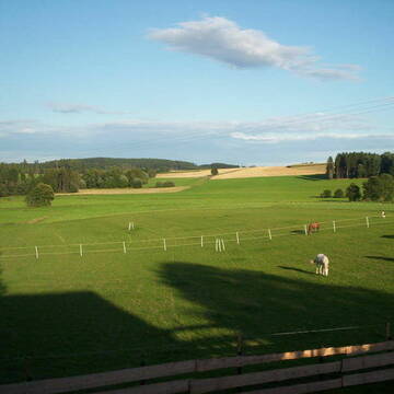
Freizeitreiter-Hof
Bayern - Hof
Janett
@Janett
FN-Mitglied
Freizeitstall
Vermieten
Hunde willkommen
Longierzirkel/Roundpen
Außenbox mit Paddock
Außenboxen
20 weitere...
P
Deprecated: Creation of dynamic property Zend_View_Helper_Ads::$adLink is deprecated in /var/www/stall-frei/htdocs/staging.stall-frei.de/library/Psf/View/Helper/Ads.php on line 108

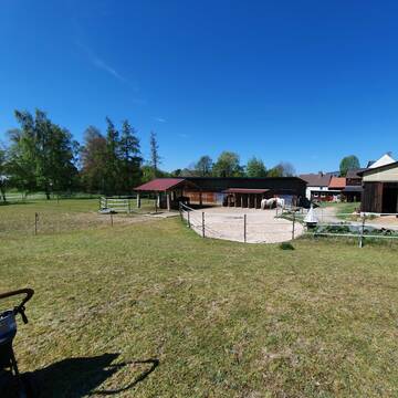
Pferdepension Hit Aktivstall Kürmerhof
Hohenkammer
Kuermerhof
@Kuermerhof
*******JETZT NEU MIT ENTSTAUBTEM BIOHEU*********
*******Demnächst mit einem Abenteuerspielplatz für Pferde ( Extrem Trail/Pa
Leider kein Vorschaubild
Leider kein Vorschaubild
Reiterhof Gut Haidt
Hof
Reiterhof Gut Haidt
@GutHaidt
Freizeitstall
Vermieten
Hunde willkommen
Paddock
Hufrehe geeignet
14 weitere...
B
Leider kein Vorschaubild
Leider kein Vorschaubild
Aktivstall Raitschin / HIT-Aktivstall
Regnitzlosau
Aktivstall-Raitschin
@Aktivstall-Raitschin
Geländestrecke
Reitlehrer und -unterricht
Longierzirkel/Roundpen
Reitplatz (z.B. Dressur, Springen, Reining)
Bewegungsstall
HIT-Aktivstall
3 weitere...
B
Pensionsstall Schallersreuth
Konradsreuth
Daniela-Caspar
@Daniela-Caspar
Freizeitstall
Geländestrecke
Paddock
Pensions- und Gastboxen
Innenbox
Einzelne Boxen oder Stallplätze
9 weitere...
P
Leider kein Vorschaubild
Leider kein Vorschaubild
Ziegelhof Oberkotzau
Oberkotzau
Ziegelhof Oberkotzau
@Ziegelhof_Oberkotzau
Freizeitstall
Hunde willkommen
Longierzirkel/Roundpen
Allergikerstall
Hufrehe geeignet
Außenbox mit Paddock
Innenbox
9 weitere...
B
Offenstall Martinlamitz
Schwarzenbach a.d. Saale
Carolin-Voigt
@Carolin-Voigt
Geländestrecke
Paddock
Reitplatz (z.B. Dressur, Springen, Reining)
Allergikerstall
Bewegungsstall
Laufstall
9 weitere...
P
Leider kein Vorschaubild
Leider kein Vorschaubild
Finca-Haideck Offenstall
Oberkotzau
Reitsport-Guhs
@Reitsport-Guhs
Freizeitstall
Pflegepferd
Vermieten
Krankenbox
Paddock
Hufrehe geeignet
19 weitere...
B

Persönlichkeitsentwicklung mit Pferden
Bad Salzuflen
Katja Dors
@Pferdezeiten
Begleite andere auf ihrem Entwicklungsweg und entdecke die transformative Kraft der pferdegestützten Persönlichkeitsentwicklung !
neu
R
Leider kein Vorschaubild
Leider kein Vorschaubild
Stall Frankenhof
Rehau
Gestuet-Frankenhof
@Gestuet-Frankenhof
Paddock
Pensions- und Gastboxen
Hengsthaltung möglich
Pferdezucht
Außenbox mit Paddock
Außenboxen
Vollpension
10 weitere...
B
Leider kein Vorschaubild
Leider kein Vorschaubild
Reitstall Winterling, Fohrenreuth
Rehau
Reitstall Winterling
@Winterling
Longierzirkel/Roundpen
Paddock
Außenbox mit Paddock
Außenboxen
Vollpension
Einzelne Boxen oder Stallplätze
7 weitere...
B
REITSTALL MECHLENREUTH - PENSIONSPFERDESTALL
Bayern - Münchberg
Reitstall_Mechlenreuth
@Reitstall_Mechlenreuth
Freizeitstall
Pferdeausbildung
Vermieten
Hunde willkommen
Laufband
Allergikerstall
17 weitere...
P
Deprecated: Creation of dynamic property Zend_View::$pageCount is deprecated in /var/www/stall-frei/htdocs/staging.stall-frei.de/library/vendor/shardj/zf1-future/library/Zend/View/Abstract.php on line 308
Deprecated: Creation of dynamic property Zend_View::$itemCountPerPage is deprecated in /var/www/stall-frei/htdocs/staging.stall-frei.de/library/vendor/shardj/zf1-future/library/Zend/View/Abstract.php on line 308
Deprecated: Creation of dynamic property Zend_View::$first is deprecated in /var/www/stall-frei/htdocs/staging.stall-frei.de/library/vendor/shardj/zf1-future/library/Zend/View/Abstract.php on line 308
Deprecated: Creation of dynamic property Zend_View::$current is deprecated in /var/www/stall-frei/htdocs/staging.stall-frei.de/library/vendor/shardj/zf1-future/library/Zend/View/Abstract.php on line 308
Deprecated: Creation of dynamic property Zend_View::$last is deprecated in /var/www/stall-frei/htdocs/staging.stall-frei.de/library/vendor/shardj/zf1-future/library/Zend/View/Abstract.php on line 308
Deprecated: Creation of dynamic property Zend_View::$next is deprecated in /var/www/stall-frei/htdocs/staging.stall-frei.de/library/vendor/shardj/zf1-future/library/Zend/View/Abstract.php on line 308
Deprecated: Creation of dynamic property Zend_View::$pagesInRange is deprecated in /var/www/stall-frei/htdocs/staging.stall-frei.de/library/vendor/shardj/zf1-future/library/Zend/View/Abstract.php on line 308
Deprecated: Creation of dynamic property Zend_View::$firstPageInRange is deprecated in /var/www/stall-frei/htdocs/staging.stall-frei.de/library/vendor/shardj/zf1-future/library/Zend/View/Abstract.php on line 308
Deprecated: Creation of dynamic property Zend_View::$lastPageInRange is deprecated in /var/www/stall-frei/htdocs/staging.stall-frei.de/library/vendor/shardj/zf1-future/library/Zend/View/Abstract.php on line 308
Deprecated: Creation of dynamic property Zend_View::$currentItemCount is deprecated in /var/www/stall-frei/htdocs/staging.stall-frei.de/library/vendor/shardj/zf1-future/library/Zend/View/Abstract.php on line 308
Deprecated: Creation of dynamic property Zend_View::$totalItemCount is deprecated in /var/www/stall-frei/htdocs/staging.stall-frei.de/library/vendor/shardj/zf1-future/library/Zend/View/Abstract.php on line 308
Deprecated: Creation of dynamic property Zend_View::$firstItemNumber is deprecated in /var/www/stall-frei/htdocs/staging.stall-frei.de/library/vendor/shardj/zf1-future/library/Zend/View/Abstract.php on line 308
Deprecated: Creation of dynamic property Zend_View::$lastItemNumber is deprecated in /var/www/stall-frei/htdocs/staging.stall-frei.de/library/vendor/shardj/zf1-future/library/Zend/View/Abstract.php on line 308
Deprecated: Creation of dynamic property Zend_View::$router is deprecated in /var/www/stall-frei/htdocs/staging.stall-frei.de/library/vendor/shardj/zf1-future/library/Zend/View/Abstract.php on line 308
Deprecated: Creation of dynamic property Zend_View::$urlParams is deprecated in /var/www/stall-frei/htdocs/staging.stall-frei.de/library/vendor/shardj/zf1-future/library/Zend/View/Abstract.php on line 308
Deprecated: Creation of dynamic property Zend_View::$showAds is deprecated in /var/www/stall-frei/htdocs/staging.stall-frei.de/library/vendor/shardj/zf1-future/library/Zend/View/Abstract.php on line 308
Deprecated: Creation of dynamic property Zend_View::$objectIds is deprecated in /var/www/stall-frei/htdocs/staging.stall-frei.de/library/vendor/shardj/zf1-future/library/Zend/View/Abstract.php on line 308
Deprecated: Creation of dynamic property Zend_View::$showNavbar is deprecated in /var/www/stall-frei/htdocs/staging.stall-frei.de/library/vendor/shardj/zf1-future/library/Zend/View/Abstract.php on line 308
Deprecated: Creation of dynamic property Zend_View::$showBreadcrumb is deprecated in /var/www/stall-frei/htdocs/staging.stall-frei.de/library/vendor/shardj/zf1-future/library/Zend/View/Abstract.php on line 308
Deprecated: Creation of dynamic property Zend_View::$showFooter is deprecated in /var/www/stall-frei/htdocs/staging.stall-frei.de/library/vendor/shardj/zf1-future/library/Zend/View/Abstract.php on line 308
Deprecated: Creation of dynamic property Zend_View::$showInternalAds is deprecated in /var/www/stall-frei/htdocs/staging.stall-frei.de/library/vendor/shardj/zf1-future/library/Zend/View/Abstract.php on line 308
Deprecated: Creation of dynamic property Zend_View::$blNoContent is deprecated in /var/www/stall-frei/htdocs/staging.stall-frei.de/library/vendor/shardj/zf1-future/library/Zend/View/Abstract.php on line 308
Deprecated: Creation of dynamic property Zend_View::$sMetaDesc is deprecated in /var/www/stall-frei/htdocs/staging.stall-frei.de/library/vendor/shardj/zf1-future/library/Zend/View/Abstract.php on line 308
Deprecated: Creation of dynamic property Zend_View::$useGmaps is deprecated in /var/www/stall-frei/htdocs/staging.stall-frei.de/library/vendor/shardj/zf1-future/library/Zend/View/Abstract.php on line 308
Deprecated: Creation of dynamic property Zend_View::$touches is deprecated in /var/www/stall-frei/htdocs/staging.stall-frei.de/library/vendor/shardj/zf1-future/library/Zend/View/Abstract.php on line 308
Deprecated: Creation of dynamic property Zend_View::$oProject is deprecated in /var/www/stall-frei/htdocs/staging.stall-frei.de/library/vendor/shardj/zf1-future/library/Zend/View/Abstract.php on line 308
Deprecated: Creation of dynamic property Zend_View::$pageHeadline is deprecated in /var/www/stall-frei/htdocs/staging.stall-frei.de/library/vendor/shardj/zf1-future/library/Zend/View/Abstract.php on line 308
Deprecated: Creation of dynamic property Zend_View::$disableLocationField is deprecated in /var/www/stall-frei/htdocs/staging.stall-frei.de/library/vendor/shardj/zf1-future/library/Zend/View/Abstract.php on line 308
Deprecated: Creation of dynamic property Zend_View::$isSearch is deprecated in /var/www/stall-frei/htdocs/staging.stall-frei.de/library/vendor/shardj/zf1-future/library/Zend/View/Abstract.php on line 308
Deprecated: Creation of dynamic property Zend_View::$pageTitle is deprecated in /var/www/stall-frei/htdocs/staging.stall-frei.de/library/vendor/shardj/zf1-future/library/Zend/View/Abstract.php on line 308
Deprecated: Creation of dynamic property Psf_Form_Element_Text::$class is deprecated in /var/www/stall-frei/htdocs/staging.stall-frei.de/library/vendor/shardj/zf1-future/library/Zend/Form/Element.php on line 874
Deprecated: Creation of dynamic property Psf_Form_Element_Text::$size is deprecated in /var/www/stall-frei/htdocs/staging.stall-frei.de/library/vendor/shardj/zf1-future/library/Zend/Form/Element.php on line 874
Deprecated: Creation of dynamic property Psf_Form_Element_Text::$placeholder is deprecated in /var/www/stall-frei/htdocs/staging.stall-frei.de/library/vendor/shardj/zf1-future/library/Zend/Form/Element.php on line 874
Deprecated: Creation of dynamic property Psf_Form_Element_Hidden::$class is deprecated in /var/www/stall-frei/htdocs/staging.stall-frei.de/library/vendor/shardj/zf1-future/library/Zend/Form/Element.php on line 874
Deprecated: Creation of dynamic property Psf_Form_Element_Hidden::$class is deprecated in /var/www/stall-frei/htdocs/staging.stall-frei.de/library/vendor/shardj/zf1-future/library/Zend/Form/Element.php on line 874
Deprecated: Creation of dynamic property Psf_Form_Element_Hidden::$class is deprecated in /var/www/stall-frei/htdocs/staging.stall-frei.de/library/vendor/shardj/zf1-future/library/Zend/Form/Element.php on line 874
Deprecated: Creation of dynamic property Psf_Form_Element_Hidden::$class is deprecated in /var/www/stall-frei/htdocs/staging.stall-frei.de/library/vendor/shardj/zf1-future/library/Zend/Form/Element.php on line 874
Deprecated: Creation of dynamic property Psf_Form_Element_Select::$class is deprecated in /var/www/stall-frei/htdocs/staging.stall-frei.de/library/vendor/shardj/zf1-future/library/Zend/Form/Element.php on line 874
Deprecated: Creation of dynamic property Psf_Form_Element_Select::$class is deprecated in /var/www/stall-frei/htdocs/staging.stall-frei.de/library/vendor/shardj/zf1-future/library/Zend/Form/Element.php on line 874
Deprecated: Creation of dynamic property Psf_Form_Element_Select::$class is deprecated in /var/www/stall-frei/htdocs/staging.stall-frei.de/library/vendor/shardj/zf1-future/library/Zend/Form/Element.php on line 874
Deprecated: Creation of dynamic property Psf_Form_Element_Select::$class is deprecated in /var/www/stall-frei/htdocs/staging.stall-frei.de/library/vendor/shardj/zf1-future/library/Zend/Form/Element.php on line 874
Deprecated: Creation of dynamic property Psf_Form_Element_Text::$class is deprecated in /var/www/stall-frei/htdocs/staging.stall-frei.de/library/vendor/shardj/zf1-future/library/Zend/Form/Element.php on line 874
Deprecated: Creation of dynamic property Psf_Form_Element_Checkbox::$label is deprecated in /var/www/stall-frei/htdocs/staging.stall-frei.de/library/vendor/shardj/zf1-future/library/Zend/Form/Element.php on line 874
Deprecated: Creation of dynamic property Zend_View::$sort is deprecated in /var/www/stall-frei/htdocs/staging.stall-frei.de/library/vendor/shardj/zf1-future/library/Zend/View/Abstract.php on line 308
Deprecated: Creation of dynamic property Zend_View::$searchLocation is deprecated in /var/www/stall-frei/htdocs/staging.stall-frei.de/library/vendor/shardj/zf1-future/library/Zend/View/Abstract.php on line 308
Deprecated: Creation of dynamic property Zend_View::$locationHint is deprecated in /var/www/stall-frei/htdocs/staging.stall-frei.de/library/vendor/shardj/zf1-future/library/Zend/View/Abstract.php on line 308
Psf_GeoCoder_Abstract::getLocation: Im Wald Get Location CachedOrLive
Psf_GeoCoder_Abstract::getCachedOrLive: Im Wald
Psf_GeoCoder_OpenCageData::makeApiRequest: response:
Array
(
[documentation] => https://opencagedata.com/api
[licenses] => Array
(
[0] => Array
(
[name] => see attribution guide
[url] => https://opencagedata.com/credits
)
)
[results] => Array
(
[0] => Array
(
[bounds] => Array
(
[northeast] => Array
(
[lat] => 50.3228352
[lng] => 11.9868816
)
[southwest] => Array
(
[lat] => 50.3227352
[lng] => 11.9867816
)
)
[components] => Array
(
[ISO_3166-1_alpha-2] => DE
[ISO_3166-1_alpha-3] => DEU
[ISO_3166-2] => Array
(
[0] => DE-BY
)
[_category] => building
[_normalized_city] => Gattendorf
[_type] => building
[city] => Gattendorf
[continent] => Europe
[country] => Deutschland
[country_code] => de
[county] => Landkreis Hof
[isolated_dwelling] => Im Wald
[municipality] => Verwaltungsgemeinschaft Feilitzsch
[political_union] => European Union
[postcode] => 95185
[state] => Bayern
[state_code] => BY
)
[confidence] => 10
[formatted] => Im Wald, 95185 Gattendorf, Deutschland
[geometry] => Array
(
[lat] => 50.3227852
[lng] => 11.9868316
)
)
[1] => Array
(
[bounds] => Array
(
[northeast] => Array
(
[lat] => 46.7275005
[lng] => 8.1845399
)
[southwest] => Array
(
[lat] => 46.7075005
[lng] => 8.1645399
)
)
[components] => Array
(
[ISO_3166-1_alpha-2] => CH
[ISO_3166-1_alpha-3] => CHE
[ISO_3166-2] => Array
(
[0] => CH-BE
)
[_category] => place
[_normalized_city] => Schattenhalb
[_type] => hamlet
[continent] => Europe
[country] => Schweiz
[country_code] => ch
[county] => Verwaltungskreis Interlaken-Oberhasli
[hamlet] => Falcheren
[local_administrative_area] => Schattenhalb
[neighbourhood] => Im Wald
[postcode] => 3860
[state] => Bern
[state_code] => BE
[state_district] => Verwaltungsregion Oberland
[village] => Schattenhalb
)
[confidence] => 8
[formatted] => 3860 Schattenhalb, Schweiz
[geometry] => Array
(
[lat] => 46.7175005
[lng] => 8.1745399
)
)
[2] => Array
(
[bounds] => Array
(
[northeast] => Array
(
[lat] => 47.1816746
[lng] => 8.6333427
)
[southwest] => Array
(
[lat] => 47.1793949
[lng] => 8.6306724
)
)
[components] => Array
(
[ISO_3166-1_alpha-2] => CH
[ISO_3166-1_alpha-3] => CHE
[ISO_3166-2] => Array
(
[0] => CH-ZH
)
[_category] => place
[_normalized_city] => Wädenswil
[_type] => hamlet
[continent] => Europe
[country] => Schweiz
[country_code] => ch
[county] => Bezirk Horgen
[local_administrative_area] => Wädenswil
[locality] => Im Wald
[postcode] => 8820
[state] => Zürich
[state_code] => ZH
[town] => Wädenswil
)
[confidence] => 9
[formatted] => 8820 Wädenswil, Schweiz
[geometry] => Array
(
[lat] => 47.1805421
[lng] => 8.6321054
)
)
[3] => Array
(
[bounds] => Array
(
[northeast] => Array
(
[lat] => 47.4858499
[lng] => 7.6559357
)
[southwest] => Array
(
[lat] => 47.4658499
[lng] => 7.6359357
)
)
[components] => Array
(
[ISO_3166-1_alpha-2] => CH
[ISO_3166-1_alpha-3] => CHE
[ISO_3166-2] => Array
(
[0] => CH-SO
)
[_category] => place
[_normalized_city] => Gempen
[_type] => hamlet
[continent] => Europe
[country] => Schweiz
[country_code] => ch
[county] => Amtei Dorneck-Thierstein
[local_administrative_area] => Gempen
[locality] => Im Wald
[municipality] => Bezirk Dorneck
[postcode] => 4145
[state] => Solothurn
[state_code] => SO
[village] => Gempen
)
[confidence] => 8
[formatted] => 4145 Bezirk Dorneck, Schweiz
[geometry] => Array
(
[lat] => 47.4758499
[lng] => 7.6459357
)
)
[4] => Array
(
[bounds] => Array
(
[northeast] => Array
(
[lat] => 48.688585
[lng] => 8.1094088
)
[southwest] => Array
(
[lat] => 48.668585
[lng] => 8.0894088
)
)
[components] => Array
(
[ISO_3166-1_alpha-2] => DE
[ISO_3166-1_alpha-3] => DEU
[ISO_3166-2] => Array
(
[0] => DE-BW
)
[_category] => place
[_normalized_city] => Ottersweier
[_type] => hamlet
[continent] => Europe
[country] => Deutschland
[country_code] => de
[county] => Landkreis Rastatt
[locality] => Im Wald
[municipality] => VVG der Stadt Bühl
[political_union] => European Union
[postcode] => 77833
[state] => Baden-Württemberg
[state_code] => BW
[village] => Ottersweier
)
[confidence] => 8
[formatted] => Im Wald, 77833 Ottersweier, Deutschland
[geometry] => Array
(
[lat] => 48.678585
[lng] => 8.0994088
)
)
[5] => Array
(
[bounds] => Array
(
[northeast] => Array
(
[lat] => 48.0137878
[lng] => 7.4936021
)
[southwest] => Array
(
[lat] => 47.9937878
[lng] => 7.4736021
)
)
[components] => Array
(
[ISO_3166-1_alpha-2] => FR
[ISO_3166-1_alpha-3] => FRA
[ISO_3166-2] => Array
(
[0] => FR-GES
[1] => FR-6AE
[2] => FR-68
)
[_category] => place
[_normalized_city] => Weckolsheim
[_type] => hamlet
[continent] => Europe
[country] => Frankreich
[country_code] => fr
[county] => Oberelsass
[local_authority] => Communauté de communes Alsace Rhin Brisach
[locality] => Im Wald
[municipality] => Colmar-Rappoltsweiler
[political_union] => European Union
[postcode] => 68600
[region] => Metropolitanes Frankreich
[state] => Grand Est
[state_code] => GES
[state_district] => Collectivité européenne d'Alsace
[village] => Weckolsheim
)
[confidence] => 8
[formatted] => 68600 Weckolsheim, Frankreich
[geometry] => Array
(
[lat] => 48.0037878
[lng] => 7.4836021
)
)
[6] => Array
(
[bounds] => Array
(
[northeast] => Array
(
[lat] => 52.2137237
[lng] => 14.0333111
)
[southwest] => Array
(
[lat] => 52.2073472
[lng] => 14.0218782
)
)
[components] => Array
(
[ISO_3166-1_alpha-2] => DE
[ISO_3166-1_alpha-3] => DEU
[ISO_3166-2] => Array
(
[0] => DE-BB
)
[_category] => road
[_normalized_city] => Wendisch Rietz
[_type] => road
[continent] => Europe
[country] => Deutschland
[country_code] => de
[county] => Oder-Spree
[hamlet] => Waldfrieden
[municipality] => Scharmützelsee
[political_union] => European Union
[postcode] => 15864
[road] => Im Wald
[road_type] => residential
[state] => Brandenburg
[state_code] => BB
[village] => Wendisch Rietz
)
[confidence] => 9
[formatted] => Im Wald, 15864 Wendisch Rietz, Deutschland
[geometry] => Array
(
[lat] => 52.2103742
[lng] => 14.0279343
)
)
[7] => Array
(
[bounds] => Array
(
[northeast] => Array
(
[lat] => 52.7159591
[lng] => 7.6594629
)
[southwest] => Array
(
[lat] => 52.7131812
[lng] => 7.6545077
)
)
[components] => Array
(
[ISO_3166-1_alpha-2] => DE
[ISO_3166-1_alpha-3] => DEU
[ISO_3166-2] => Array
(
[0] => DE-NI
)
[_category] => road
[_normalized_city] => Löningen
[_type] => road
[continent] => Europe
[country] => Deutschland
[country_code] => de
[county] => Landkreis Cloppenburg
[hamlet] => Lewinghausen
[political_union] => European Union
[postcode] => 49624
[road] => Im Wald
[road_type] => track
[state] => Niedersachsen
[state_code] => NI
[town] => Löningen
)
[confidence] => 9
[formatted] => Im Wald, 49624 Löningen, Deutschland
[geometry] => Array
(
[lat] => 52.7145508
[lng] => 7.6569795
)
)
[8] => Array
(
[bounds] => Array
(
[northeast] => Array
(
[lat] => 50.5080703
[lng] => 7.150339
)
[southwest] => Array
(
[lat] => 50.5039496
[lng] => 7.1488497
)
)
[components] => Array
(
[ISO_3166-1_alpha-2] => DE
[ISO_3166-1_alpha-3] => DEU
[ISO_3166-2] => Array
(
[0] => DE-RP
)
[_category] => road
[_normalized_city] => Königsfeld
[_type] => road
[continent] => Europe
[country] => Deutschland
[country_code] => de
[county] => Landkreis Ahrweiler
[municipality] => Brohltal
[political_union] => European Union
[postcode] => 53426
[road] => Im Wald
[road_type] => track
[state] => Rheinland-Pfalz
[state_code] => RP
[village] => Königsfeld
)
[confidence] => 9
[formatted] => Im Wald, 53426 Königsfeld, Deutschland
[geometry] => Array
(
[lat] => 50.5062127
[lng] => 7.1503287
)
)
[9] => Array
(
[bounds] => Array
(
[northeast] => Array
(
[lat] => 52.8597617
[lng] => 7.7773058
)
[southwest] => Array
(
[lat] => 52.858884
[lng] => 7.773426
)
)
[components] => Array
(
[ISO_3166-1_alpha-2] => DE
[ISO_3166-1_alpha-3] => DEU
[ISO_3166-2] => Array
(
[0] => DE-NI
)
[_category] => road
[_normalized_city] => Lindern (Oldenburg)
[_type] => road
[continent] => Europe
[country] => Deutschland
[country_code] => de
[county] => Landkreis Cloppenburg
[political_union] => European Union
[postcode] => 49699
[road] => Im Wald
[state] => Niedersachsen
[state_code] => NI
[village] => Lindern (Oldenburg)
)
[confidence] => 9
[formatted] => Im Wald, 49699 Lindern (Oldenburg), Deutschland
[geometry] => Array
(
[lat] => 52.8591302
[lng] => 7.7751476
)
)
)
[status] => Array
(
[code] => 200
[message] => OK
)
[stay_informed] => Array
(
[blog] => https://blog.opencagedata.com
[mastodon] => https://en.osm.town/@opencage
)
[thanks] => For using an OpenCage API
[timestamp] => Array
(
[created_http] => Mon, 09 Feb 2026 04:15:12 GMT
[created_unix] => 1770610512
)
[total_results] => 10
)
Psf_GeoCoder_Abstract::convertLocationResult
{"documentation":"https:\/\/opencagedata.com\/api","licenses":[{"name":"see attribution guide","url":"https:\/\/opencagedata.com\/credits"}],"results":[{"bounds":{"northeast":{"lat":50.3228352,"lng":11.9868816},"southwest":{"lat":50.3227352,"lng":11.9867816}},"components":{"ISO_3166-1_alpha-2":"DE","ISO_3166-1_alpha-3":"DEU","ISO_3166-2":["DE-BY"],"_category":"building","_normalized_city":"Gattendorf","_type":"building","city":"Gattendorf","continent":"Europe","country":"Deutschland","country_code":"de","county":"Landkreis Hof","isolated_dwelling":"Im Wald","municipality":"Verwaltungsgemeinschaft Feilitzsch","political_union":"European Union","postcode":"95185","state":"Bayern","state_code":"BY"},"confidence":10,"formatted":"Im Wald, 95185 Gattendorf, Deutschland","geometry":{"lat":50.3227852,"lng":11.9868316}},{"bounds":{"northeast":{"lat":46.7275005,"lng":8.1845399},"southwest":{"lat":46.7075005,"lng":8.1645399}},"components":{"ISO_3166-1_alpha-2":"CH","ISO_3166-1_alpha-3":"CHE","ISO_3166-2":["CH-BE"],"_category":"place","_normalized_city":"Schattenhalb","_type":"hamlet","continent":"Europe","country":"Schweiz","country_code":"ch","county":"Verwaltungskreis Interlaken-Oberhasli","hamlet":"Falcheren","local_administrative_area":"Schattenhalb","neighbourhood":"Im Wald","postcode":"3860","state":"Bern","state_code":"BE","state_district":"Verwaltungsregion Oberland","village":"Schattenhalb"},"confidence":8,"formatted":"3860 Schattenhalb, Schweiz","geometry":{"lat":46.7175005,"lng":8.1745399}},{"bounds":{"northeast":{"lat":47.1816746,"lng":8.6333427},"southwest":{"lat":47.1793949,"lng":8.6306724}},"components":{"ISO_3166-1_alpha-2":"CH","ISO_3166-1_alpha-3":"CHE","ISO_3166-2":["CH-ZH"],"_category":"place","_normalized_city":"W\u00e4denswil","_type":"hamlet","continent":"Europe","country":"Schweiz","country_code":"ch","county":"Bezirk Horgen","local_administrative_area":"W\u00e4denswil","locality":"Im Wald","postcode":"8820","state":"Z\u00fcrich","state_code":"ZH","town":"W\u00e4denswil"},"confidence":9,"formatted":"8820 W\u00e4denswil, Schweiz","geometry":{"lat":47.1805421,"lng":8.6321054}},{"bounds":{"northeast":{"lat":47.4858499,"lng":7.6559357},"southwest":{"lat":47.4658499,"lng":7.6359357}},"components":{"ISO_3166-1_alpha-2":"CH","ISO_3166-1_alpha-3":"CHE","ISO_3166-2":["CH-SO"],"_category":"place","_normalized_city":"Gempen","_type":"hamlet","continent":"Europe","country":"Schweiz","country_code":"ch","county":"Amtei Dorneck-Thierstein","local_administrative_area":"Gempen","locality":"Im Wald","municipality":"Bezirk Dorneck","postcode":"4145","state":"Solothurn","state_code":"SO","village":"Gempen"},"confidence":8,"formatted":"4145 Bezirk Dorneck, Schweiz","geometry":{"lat":47.4758499,"lng":7.6459357}},{"bounds":{"northeast":{"lat":48.688585,"lng":8.1094088},"southwest":{"lat":48.668585,"lng":8.0894088}},"components":{"ISO_3166-1_alpha-2":"DE","ISO_3166-1_alpha-3":"DEU","ISO_3166-2":["DE-BW"],"_category":"place","_normalized_city":"Ottersweier","_type":"hamlet","continent":"Europe","country":"Deutschland","country_code":"de","county":"Landkreis Rastatt","locality":"Im Wald","municipality":"VVG der Stadt B\u00fchl","political_union":"European Union","postcode":"77833","state":"Baden-W\u00fcrttemberg","state_code":"BW","village":"Ottersweier"},"confidence":8,"formatted":"Im Wald, 77833 Ottersweier, Deutschland","geometry":{"lat":48.678585,"lng":8.0994088}},{"bounds":{"northeast":{"lat":48.0137878,"lng":7.4936021},"southwest":{"lat":47.9937878,"lng":7.4736021}},"components":{"ISO_3166-1_alpha-2":"FR","ISO_3166-1_alpha-3":"FRA","ISO_3166-2":["FR-GES","FR-6AE","FR-68"],"_category":"place","_normalized_city":"Weckolsheim","_type":"hamlet","continent":"Europe","country":"Frankreich","country_code":"fr","county":"Oberelsass","local_authority":"Communaut\u00e9 de communes Alsace Rhin Brisach","locality":"Im Wald","municipality":"Colmar-Rappoltsweiler","political_union":"European Union","postcode":"68600","region":"Metropolitanes Frankreich","state":"Grand Est","state_code":"GES","state_district":"Collectivit\u00e9 europ\u00e9enne d'Alsace","village":"Weckolsheim"},"confidence":8,"formatted":"68600 Weckolsheim, Frankreich","geometry":{"lat":48.0037878,"lng":7.4836021}},{"bounds":{"northeast":{"lat":52.2137237,"lng":14.0333111},"southwest":{"lat":52.2073472,"lng":14.0218782}},"components":{"ISO_3166-1_alpha-2":"DE","ISO_3166-1_alpha-3":"DEU","ISO_3166-2":["DE-BB"],"_category":"road","_normalized_city":"Wendisch Rietz","_type":"road","continent":"Europe","country":"Deutschland","country_code":"de","county":"Oder-Spree","hamlet":"Waldfrieden","municipality":"Scharm\u00fctzelsee","political_union":"European Union","postcode":"15864","road":"Im Wald","road_type":"residential","state":"Brandenburg","state_code":"BB","village":"Wendisch Rietz"},"confidence":9,"formatted":"Im Wald, 15864 Wendisch Rietz, Deutschland","geometry":{"lat":52.2103742,"lng":14.0279343}},{"bounds":{"northeast":{"lat":52.7159591,"lng":7.6594629},"southwest":{"lat":52.7131812,"lng":7.6545077}},"components":{"ISO_3166-1_alpha-2":"DE","ISO_3166-1_alpha-3":"DEU","ISO_3166-2":["DE-NI"],"_category":"road","_normalized_city":"L\u00f6ningen","_type":"road","continent":"Europe","country":"Deutschland","country_code":"de","county":"Landkreis Cloppenburg","hamlet":"Lewinghausen","political_union":"European Union","postcode":"49624","road":"Im Wald","road_type":"track","state":"Niedersachsen","state_code":"NI","town":"L\u00f6ningen"},"confidence":9,"formatted":"Im Wald, 49624 L\u00f6ningen, Deutschland","geometry":{"lat":52.7145508,"lng":7.6569795}},{"bounds":{"northeast":{"lat":50.5080703,"lng":7.150339},"southwest":{"lat":50.5039496,"lng":7.1488497}},"components":{"ISO_3166-1_alpha-2":"DE","ISO_3166-1_alpha-3":"DEU","ISO_3166-2":["DE-RP"],"_category":"road","_normalized_city":"K\u00f6nigsfeld","_type":"road","continent":"Europe","country":"Deutschland","country_code":"de","county":"Landkreis Ahrweiler","municipality":"Brohltal","political_union":"European Union","postcode":"53426","road":"Im Wald","road_type":"track","state":"Rheinland-Pfalz","state_code":"RP","village":"K\u00f6nigsfeld"},"confidence":9,"formatted":"Im Wald, 53426 K\u00f6nigsfeld, Deutschland","geometry":{"lat":50.5062127,"lng":7.1503287}},{"bounds":{"northeast":{"lat":52.8597617,"lng":7.7773058},"southwest":{"lat":52.858884,"lng":7.773426}},"components":{"ISO_3166-1_alpha-2":"DE","ISO_3166-1_alpha-3":"DEU","ISO_3166-2":["DE-NI"],"_category":"road","_normalized_city":"Lindern (Oldenburg)","_type":"road","continent":"Europe","country":"Deutschland","country_code":"de","county":"Landkreis Cloppenburg","political_union":"European Union","postcode":"49699","road":"Im Wald","state":"Niedersachsen","state_code":"NI","village":"Lindern (Oldenburg)"},"confidence":9,"formatted":"Im Wald, 49699 Lindern (Oldenburg), Deutschland","geometry":{"lat":52.8591302,"lng":7.7751476}}],"status":{"code":200,"message":"OK"},"stay_informed":{"blog":"https:\/\/blog.opencagedata.com","mastodon":"https:\/\/en.osm.town\/@opencage"},"thanks":"For using an OpenCage API","timestamp":{"created_http":"Mon, 09 Feb 2026 04:15:12 GMT","created_unix":1770610512},"total_results":10}Array
(
[0] => stdClass Object
(
[bounds] => stdClass Object
(
[northeast] => stdClass Object
(
[lat] => 50.3228352
[lng] => 11.9868816
)
[southwest] => stdClass Object
(
[lat] => 50.3227352
[lng] => 11.9867816
)
)
[components] => stdClass Object
(
[ISO_3166-1_alpha-2] => DE
[ISO_3166-1_alpha-3] => DEU
[ISO_3166-2] => Array
(
[0] => DE-BY
)
[_category] => building
[_normalized_city] => Gattendorf
[_type] => building
[city] => Gattendorf
[continent] => Europe
[country] => Deutschland
[country_code] => de
[county] => Landkreis Hof
[isolated_dwelling] => Im Wald
[municipality] => Verwaltungsgemeinschaft Feilitzsch
[political_union] => European Union
[postcode] => 95185
[state] => Bayern
[state_code] => BY
)
[confidence] => 10
[formatted] => Im Wald, 95185 Gattendorf, Deutschland
[geometry] => stdClass Object
(
[lat] => 50.3227852
[lng] => 11.9868316
)
)
[1] => stdClass Object
(
[bounds] => stdClass Object
(
[northeast] => stdClass Object
(
[lat] => 46.7275005
[lng] => 8.1845399
)
[southwest] => stdClass Object
(
[lat] => 46.7075005
[lng] => 8.1645399
)
)
[components] => stdClass Object
(
[ISO_3166-1_alpha-2] => CH
[ISO_3166-1_alpha-3] => CHE
[ISO_3166-2] => Array
(
[0] => CH-BE
)
[_category] => place
[_normalized_city] => Schattenhalb
[_type] => hamlet
[continent] => Europe
[country] => Schweiz
[country_code] => ch
[county] => Verwaltungskreis Interlaken-Oberhasli
[hamlet] => Falcheren
[local_administrative_area] => Schattenhalb
[neighbourhood] => Im Wald
[postcode] => 3860
[state] => Bern
[state_code] => BE
[state_district] => Verwaltungsregion Oberland
[village] => Schattenhalb
)
[confidence] => 8
[formatted] => 3860 Schattenhalb, Schweiz
[geometry] => stdClass Object
(
[lat] => 46.7175005
[lng] => 8.1745399
)
)
[2] => stdClass Object
(
[bounds] => stdClass Object
(
[northeast] => stdClass Object
(
[lat] => 47.1816746
[lng] => 8.6333427
)
[southwest] => stdClass Object
(
[lat] => 47.1793949
[lng] => 8.6306724
)
)
[components] => stdClass Object
(
[ISO_3166-1_alpha-2] => CH
[ISO_3166-1_alpha-3] => CHE
[ISO_3166-2] => Array
(
[0] => CH-ZH
)
[_category] => place
[_normalized_city] => Wädenswil
[_type] => hamlet
[continent] => Europe
[country] => Schweiz
[country_code] => ch
[county] => Bezirk Horgen
[local_administrative_area] => Wädenswil
[locality] => Im Wald
[postcode] => 8820
[state] => Zürich
[state_code] => ZH
[town] => Wädenswil
)
[confidence] => 9
[formatted] => 8820 Wädenswil, Schweiz
[geometry] => stdClass Object
(
[lat] => 47.1805421
[lng] => 8.6321054
)
)
[3] => stdClass Object
(
[bounds] => stdClass Object
(
[northeast] => stdClass Object
(
[lat] => 47.4858499
[lng] => 7.6559357
)
[southwest] => stdClass Object
(
[lat] => 47.4658499
[lng] => 7.6359357
)
)
[components] => stdClass Object
(
[ISO_3166-1_alpha-2] => CH
[ISO_3166-1_alpha-3] => CHE
[ISO_3166-2] => Array
(
[0] => CH-SO
)
[_category] => place
[_normalized_city] => Gempen
[_type] => hamlet
[continent] => Europe
[country] => Schweiz
[country_code] => ch
[county] => Amtei Dorneck-Thierstein
[local_administrative_area] => Gempen
[locality] => Im Wald
[municipality] => Bezirk Dorneck
[postcode] => 4145
[state] => Solothurn
[state_code] => SO
[village] => Gempen
)
[confidence] => 8
[formatted] => 4145 Bezirk Dorneck, Schweiz
[geometry] => stdClass Object
(
[lat] => 47.4758499
[lng] => 7.6459357
)
)
[4] => stdClass Object
(
[bounds] => stdClass Object
(
[northeast] => stdClass Object
(
[lat] => 48.688585
[lng] => 8.1094088
)
[southwest] => stdClass Object
(
[lat] => 48.668585
[lng] => 8.0894088
)
)
[components] => stdClass Object
(
[ISO_3166-1_alpha-2] => DE
[ISO_3166-1_alpha-3] => DEU
[ISO_3166-2] => Array
(
[0] => DE-BW
)
[_category] => place
[_normalized_city] => Ottersweier
[_type] => hamlet
[continent] => Europe
[country] => Deutschland
[country_code] => de
[county] => Landkreis Rastatt
[locality] => Im Wald
[municipality] => VVG der Stadt Bühl
[political_union] => European Union
[postcode] => 77833
[state] => Baden-Württemberg
[state_code] => BW
[village] => Ottersweier
)
[confidence] => 8
[formatted] => Im Wald, 77833 Ottersweier, Deutschland
[geometry] => stdClass Object
(
[lat] => 48.678585
[lng] => 8.0994088
)
)
[5] => stdClass Object
(
[bounds] => stdClass Object
(
[northeast] => stdClass Object
(
[lat] => 48.0137878
[lng] => 7.4936021
)
[southwest] => stdClass Object
(
[lat] => 47.9937878
[lng] => 7.4736021
)
)
[components] => stdClass Object
(
[ISO_3166-1_alpha-2] => FR
[ISO_3166-1_alpha-3] => FRA
[ISO_3166-2] => Array
(
[0] => FR-GES
[1] => FR-6AE
[2] => FR-68
)
[_category] => place
[_normalized_city] => Weckolsheim
[_type] => hamlet
[continent] => Europe
[country] => Frankreich
[country_code] => fr
[county] => Oberelsass
[local_authority] => Communauté de communes Alsace Rhin Brisach
[locality] => Im Wald
[municipality] => Colmar-Rappoltsweiler
[political_union] => European Union
[postcode] => 68600
[region] => Metropolitanes Frankreich
[state] => Grand Est
[state_code] => GES
[state_district] => Collectivité européenne d'Alsace
[village] => Weckolsheim
)
[confidence] => 8
[formatted] => 68600 Weckolsheim, Frankreich
[geometry] => stdClass Object
(
[lat] => 48.0037878
[lng] => 7.4836021
)
)
[6] => stdClass Object
(
[bounds] => stdClass Object
(
[northeast] => stdClass Object
(
[lat] => 52.2137237
[lng] => 14.0333111
)
[southwest] => stdClass Object
(
[lat] => 52.2073472
[lng] => 14.0218782
)
)
[components] => stdClass Object
(
[ISO_3166-1_alpha-2] => DE
[ISO_3166-1_alpha-3] => DEU
[ISO_3166-2] => Array
(
[0] => DE-BB
)
[_category] => road
[_normalized_city] => Wendisch Rietz
[_type] => road
[continent] => Europe
[country] => Deutschland
[country_code] => de
[county] => Oder-Spree
[hamlet] => Waldfrieden
[municipality] => Scharmützelsee
[political_union] => European Union
[postcode] => 15864
[road] => Im Wald
[road_type] => residential
[state] => Brandenburg
[state_code] => BB
[village] => Wendisch Rietz
)
[confidence] => 9
[formatted] => Im Wald, 15864 Wendisch Rietz, Deutschland
[geometry] => stdClass Object
(
[lat] => 52.2103742
[lng] => 14.0279343
)
)
[7] => stdClass Object
(
[bounds] => stdClass Object
(
[northeast] => stdClass Object
(
[lat] => 52.7159591
[lng] => 7.6594629
)
[southwest] => stdClass Object
(
[lat] => 52.7131812
[lng] => 7.6545077
)
)
[components] => stdClass Object
(
[ISO_3166-1_alpha-2] => DE
[ISO_3166-1_alpha-3] => DEU
[ISO_3166-2] => Array
(
[0] => DE-NI
)
[_category] => road
[_normalized_city] => Löningen
[_type] => road
[continent] => Europe
[country] => Deutschland
[country_code] => de
[county] => Landkreis Cloppenburg
[hamlet] => Lewinghausen
[political_union] => European Union
[postcode] => 49624
[road] => Im Wald
[road_type] => track
[state] => Niedersachsen
[state_code] => NI
[town] => Löningen
)
[confidence] => 9
[formatted] => Im Wald, 49624 Löningen, Deutschland
[geometry] => stdClass Object
(
[lat] => 52.7145508
[lng] => 7.6569795
)
)
[8] => stdClass Object
(
[bounds] => stdClass Object
(
[northeast] => stdClass Object
(
[lat] => 50.5080703
[lng] => 7.150339
)
[southwest] => stdClass Object
(
[lat] => 50.5039496
[lng] => 7.1488497
)
)
[components] => stdClass Object
(
[ISO_3166-1_alpha-2] => DE
[ISO_3166-1_alpha-3] => DEU
[ISO_3166-2] => Array
(
[0] => DE-RP
)
[_category] => road
[_normalized_city] => Königsfeld
[_type] => road
[continent] => Europe
[country] => Deutschland
[country_code] => de
[county] => Landkreis Ahrweiler
[municipality] => Brohltal
[political_union] => European Union
[postcode] => 53426
[road] => Im Wald
[road_type] => track
[state] => Rheinland-Pfalz
[state_code] => RP
[village] => Königsfeld
)
[confidence] => 9
[formatted] => Im Wald, 53426 Königsfeld, Deutschland
[geometry] => stdClass Object
(
[lat] => 50.5062127
[lng] => 7.1503287
)
)
[9] => stdClass Object
(
[bounds] => stdClass Object
(
[northeast] => stdClass Object
(
[lat] => 52.8597617
[lng] => 7.7773058
)
[southwest] => stdClass Object
(
[lat] => 52.858884
[lng] => 7.773426
)
)
[components] => stdClass Object
(
[ISO_3166-1_alpha-2] => DE
[ISO_3166-1_alpha-3] => DEU
[ISO_3166-2] => Array
(
[0] => DE-NI
)
[_category] => road
[_normalized_city] => Lindern (Oldenburg)
[_type] => road
[continent] => Europe
[country] => Deutschland
[country_code] => de
[county] => Landkreis Cloppenburg
[political_union] => European Union
[postcode] => 49699
[road] => Im Wald
[state] => Niedersachsen
[state_code] => NI
[village] => Lindern (Oldenburg)
)
[confidence] => 9
[formatted] => Im Wald, 49699 Lindern (Oldenburg), Deutschland
[geometry] => stdClass Object
(
[lat] => 52.8591302
[lng] => 7.7751476
)
)
)
Psf_GeoCoder_OpenCageData::getKeyMap: 0
stdClass Object
(
    [bounds] => stdClass Object
        (
            [northeast] => stdClass Object
                (
                    [lat] => 50.3228352
                    [lng] => 11.9868816
                )

            [southwest] => stdClass Object
                (
                    [lat] => 50.3227352
                    [lng] => 11.9867816
                )

        )

    [components] => stdClass Object
        (
            [ISO_3166-1_alpha-2] => DE
            [ISO_3166-1_alpha-3] => DEU
            [ISO_3166-2] => Array
                (
                    [0] => DE-BY
                )

            [_category] => building
            [_normalized_city] => Gattendorf
            [_type] => building
            [city] => Gattendorf
            [continent] => Europe
            [country] => Deutschland
            [country_code] => de
            [county] => Landkreis Hof
            [isolated_dwelling] => Im Wald
            [municipality] => Verwaltungsgemeinschaft Feilitzsch
            [political_union] => European Union
            [postcode] => 95185
            [state] => Bayern
            [state_code] => BY
        )

    [confidence] => 10
    [formatted] => Im Wald, 95185 Gattendorf, Deutschland
    [geometry] => stdClass Object
        (
            [lat] => 50.3227852
            [lng] => 11.9868316
        )

)
Psf_GeoCoder_OpenCageData::getCounty: Hof
Psf_GeoCoder_OpenCageData::addMissingData REFETCH!
Array
(
    [address] => Im Wald, 95185 Gattendorf, Deutschland
    [type] => building
    [street] =>
    [city] => Gattendorf
    [county] => Hof
    [state] => Bayern
    [zip] => 95185
    [country] => Deutschland
    [suburb] =>
    [countrycode] => de
    [latitude] => 50.3227852
    [longitude] => 11.9868316
    [accuracy] => 1
    [confidence] => 10
    [bounds] => stdClass Object
        (
            [northeast] => stdClass Object
                (
                    [lat] => 50.3228352
                    [lng] => 11.9868816
                )

            [southwest] => stdClass Object
                (
                    [lat] => 50.3227352
                    [lng] => 11.9867816
                )

        )

)
reformat!
Array
(
    [address] => Im Wald, 95185 Gattendorf, Deutschland
    [type] => building
    [street] =>
    [city] => Gattendorf
    [county] => Hof
    [state] => Bayern
    [zip] => 95185
    [country] => Deutschland
    [suburb] =>
    [countrycode] => de
    [latitude] => 50.3227852
    [longitude] => 11.9868316
    [accuracy] => 1
    [confidence] => 10
    [bounds] => stdClass Object
        (
            [northeast] => stdClass Object
                (
                    [lat] => 50.3228352
                    [lng] => 11.9868816
                )

            [southwest] => stdClass Object
                (
                    [lat] => 50.3227352
                    [lng] => 11.9867816
                )

        )

    [place] => 95185 Gattendorf, Bayern
    [hash] => bd94d3d9bd9a0ffb1683d813d2a45a96
)
Psf_GeoCoder_OpenCageData::getKeyMap: 1
stdClass Object
(
    [bounds] => stdClass Object
        (
            [northeast] => stdClass Object
                (
                    [lat] => 46.7275005
                    [lng] => 8.1845399
                )

            [southwest] => stdClass Object
                (
                    [lat] => 46.7075005
                    [lng] => 8.1645399
                )

        )

    [components] => stdClass Object
        (
            [ISO_3166-1_alpha-2] => CH
            [ISO_3166-1_alpha-3] => CHE
            [ISO_3166-2] => Array
                (
                    [0] => CH-BE
                )

            [_category] => place
            [_normalized_city] => Schattenhalb
            [_type] => hamlet
            [continent] => Europe
            [country] => Schweiz
            [country_code] => ch
            [county] => Verwaltungskreis Interlaken-Oberhasli
            [hamlet] => Falcheren
            [local_administrative_area] => Schattenhalb
            [neighbourhood] => Im Wald
            [postcode] => 3860
            [state] => Bern
            [state_code] => BE
            [state_district] => Verwaltungsregion Oberland
            [village] => Schattenhalb
        )

    [confidence] => 8
    [formatted] => 3860 Schattenhalb, Schweiz
    [geometry] => stdClass Object
        (
            [lat] => 46.7175005
            [lng] => 8.1745399
        )

)
Psf_GeoCoder_OpenCageData::getCounty: Verwaltungskreis Interlaken-Oberhasli
Psf_GeoCoder_OpenCageData::addMissingData REFETCH!
Array
(
    [address] => 3860 Schattenhalb, Schweiz
    [type] => hamlet
    [street] => Falcheren
    [city] => Schattenhalb
    [county] => Verwaltungskreis Interlaken-Oberhasli
    [state] => Bern
    [zip] => 3860
    [country] => Schweiz
    [suburb] =>
    [countrycode] => ch
    [latitude] => 46.7175005
    [longitude] => 8.1745399
    [accuracy] => 1
    [confidence] => 8
    [bounds] => stdClass Object
        (
            [northeast] => stdClass Object
                (
                    [lat] => 46.7275005
                    [lng] => 8.1845399
                )

            [southwest] => stdClass Object
                (
                    [lat] => 46.7075005
                    [lng] => 8.1645399
                )

        )

)
reformat!
Array
(
    [address] => 3860 Schattenhalb, Schweiz
    [type] => hamlet
    [street] => Falcheren
    [city] => Schattenhalb
    [county] => Verwaltungskreis Interlaken-Oberhasli
    [state] => Bern
    [zip] => 3860
    [country] => Schweiz
    [suburb] =>
    [countrycode] => ch
    [latitude] => 46.7175005
    [longitude] => 8.1745399
    [accuracy] => 1
    [confidence] => 8
    [bounds] => stdClass Object
        (
            [northeast] => stdClass Object
                (
                    [lat] => 46.7275005
                    [lng] => 8.1845399
                )

            [southwest] => stdClass Object
                (
                    [lat] => 46.7075005
                    [lng] => 8.1645399
                )

        )

    [place] => Falcheren, 3860 Schattenhalb, Bern
    [hash] => a15c53e0b41e20408865b7f04a6c86fd
)
Psf_GeoCoder_OpenCageData::getKeyMap: 2
stdClass Object
(
    [bounds] => stdClass Object
        (
            [northeast] => stdClass Object
                (
                    [lat] => 47.1816746
                    [lng] => 8.6333427
                )

            [southwest] => stdClass Object
                (
                    [lat] => 47.1793949
                    [lng] => 8.6306724
                )

        )

    [components] => stdClass Object
        (
            [ISO_3166-1_alpha-2] => CH
            [ISO_3166-1_alpha-3] => CHE
            [ISO_3166-2] => Array
                (
                    [0] => CH-ZH
                )

            [_category] => place
            [_normalized_city] => Wädenswil
            [_type] => hamlet
            [continent] => Europe
            [country] => Schweiz
            [country_code] => ch
            [county] => Bezirk Horgen
            [local_administrative_area] => Wädenswil
            [locality] => Im Wald
            [postcode] => 8820
            [state] => Zürich
            [state_code] => ZH
            [town] => Wädenswil
        )

    [confidence] => 9
    [formatted] => 8820 Wädenswil, Schweiz
    [geometry] => stdClass Object
        (
            [lat] => 47.1805421
            [lng] => 8.6321054
        )

)
Psf_GeoCoder_OpenCageData::getCounty: Bezirk Horgen
Psf_GeoCoder_OpenCageData::addMissingData REFETCH!
Array
(
    [address] => 8820 Wädenswil, Schweiz
    [type] => hamlet
    [street] =>
    [city] => Wädenswil
    [county] => Bezirk Horgen
    [state] => Zürich
    [zip] => 8820
    [country] => Schweiz
    [suburb] =>
    [countrycode] => ch
    [latitude] => 47.1805421
    [longitude] => 8.6321054
    [accuracy] => 1
    [confidence] => 9
    [bounds] => stdClass Object
        (
            [northeast] => stdClass Object
                (
                    [lat] => 47.1816746
                    [lng] => 8.6333427
                )

            [southwest] => stdClass Object
                (
                    [lat] => 47.1793949
                    [lng] => 8.6306724
                )

        )

)
reformat!
Array
(
    [address] => 8820 Wädenswil, Schweiz
    [type] => hamlet
    [street] =>
    [city] => Wädenswil
    [county] => Bezirk Horgen
    [state] => Zürich
    [zip] => 8820
    [country] => Schweiz
    [suburb] =>
    [countrycode] => ch
    [latitude] => 47.1805421
    [longitude] => 8.6321054
    [accuracy] => 1
    [confidence] => 9
    [bounds] => stdClass Object
        (
            [northeast] => stdClass Object
                (
                    [lat] => 47.1816746
                    [lng] => 8.6333427
                )

            [southwest] => stdClass Object
                (
                    [lat] => 47.1793949
                    [lng] => 8.6306724
                )

        )

    [place] => 8820 Wädenswil, Zürich
    [hash] => 20108f32ac2d1a57d2e4b3f287239060
)
Psf_GeoCoder_OpenCageData::getKeyMap: 3
stdClass Object
(
    [bounds] => stdClass Object
        (
            [northeast] => stdClass Object
                (
                    [lat] => 47.4858499
                    [lng] => 7.6559357
                )

            [southwest] => stdClass Object
                (
                    [lat] => 47.4658499
                    [lng] => 7.6359357
                )

        )

    [components] => stdClass Object
        (
            [ISO_3166-1_alpha-2] => CH
            [ISO_3166-1_alpha-3] => CHE
            [ISO_3166-2] => Array
                (
                    [0] => CH-SO
                )

            [_category] => place
            [_normalized_city] => Gempen
            [_type] => hamlet
            [continent] => Europe
            [country] => Schweiz
            [country_code] => ch
            [county] => Amtei Dorneck-Thierstein
            [local_administrative_area] => Gempen
            [locality] => Im Wald
            [municipality] => Bezirk Dorneck
            [postcode] => 4145
            [state] => Solothurn
            [state_code] => SO
            [village] => Gempen
        )

    [confidence] => 8
    [formatted] => 4145 Bezirk Dorneck, Schweiz
    [geometry] => stdClass Object
        (
            [lat] => 47.4758499
            [lng] => 7.6459357
        )

)
Psf_GeoCoder_OpenCageData::getCounty: Amtei Dorneck-Thierstein
Psf_GeoCoder_OpenCageData::addMissingData REFETCH!
Array
(
    [address] => 4145 Bezirk Dorneck, Schweiz
    [type] => hamlet
    [street] =>
    [city] => Gempen
    [county] => Amtei Dorneck-Thierstein
    [state] => Solothurn
    [zip] => 4145
    [country] => Schweiz
    [suburb] =>
    [countrycode] => ch
    [latitude] => 47.4758499
    [longitude] => 7.6459357
    [accuracy] => 1
    [confidence] => 8
    [bounds] => stdClass Object
        (
            [northeast] => stdClass Object
                (
                    [lat] => 47.4858499
                    [lng] => 7.6559357
                )

            [southwest] => stdClass Object
                (
                    [lat] => 47.4658499
                    [lng] => 7.6359357
                )

        )

)
reformat!
Array
(
    [address] => 4145 Gempen
    [type] => hamlet
    [street] =>
    [city] => Gempen
    [county] => Amtei Dorneck-Thierstein
    [state] => Solothurn
    [zip] => 4145
    [country] => Schweiz
    [suburb] =>
    [countrycode] => ch
    [latitude] => 47.4758499
    [longitude] => 7.6459357
    [accuracy] => 1
    [confidence] => 8
    [bounds] => stdClass Object
        (
            [northeast] => stdClass Object
                (
                    [lat] => 47.4858499
                    [lng] => 7.6559357
                )

            [southwest] => stdClass Object
                (
                    [lat] => 47.4658499
                    [lng] => 7.6359357
                )

        )

    [place] => 4145 Gempen, Solothurn
    [hash] => 87b364b58e7a9f5423c098ce52be48f3
)
Psf_GeoCoder_OpenCageData::getKeyMap: 4
stdClass Object
(
    [bounds] => stdClass Object
        (
            [northeast] => stdClass Object
                (
                    [lat] => 48.688585
                    [lng] => 8.1094088
                )

            [southwest] => stdClass Object
                (
                    [lat] => 48.668585
                    [lng] => 8.0894088
                )

        )

    [components] => stdClass Object
        (
            [ISO_3166-1_alpha-2] => DE
            [ISO_3166-1_alpha-3] => DEU
            [ISO_3166-2] => Array
                (
                    [0] => DE-BW
                )

            [_category] => place
            [_normalized_city] => Ottersweier
            [_type] => hamlet
            [continent] => Europe
            [country] => Deutschland
            [country_code] => de
            [county] => Landkreis Rastatt
            [locality] => Im Wald
            [municipality] => VVG der Stadt Bühl
            [political_union] => European Union
            [postcode] => 77833
            [state] => Baden-Württemberg
            [state_code] => BW
            [village] => Ottersweier
        )

    [confidence] => 8
    [formatted] => Im Wald, 77833 Ottersweier, Deutschland
    [geometry] => stdClass Object
        (
            [lat] => 48.678585
            [lng] => 8.0994088
        )

)
Psf_GeoCoder_OpenCageData::getCounty: Rastatt
Psf_GeoCoder_OpenCageData::addMissingData REFETCH!
Array
(
    [address] => Im Wald, 77833 Ottersweier, Deutschland
    [type] => hamlet
    [street] =>
    [city] => Ottersweier
    [county] => Rastatt
    [state] => Baden-Württemberg
    [zip] => 77833
    [country] => Deutschland
    [suburb] =>
    [countrycode] => de
    [latitude] => 48.678585
    [longitude] => 8.0994088
    [accuracy] => 1
    [confidence] => 8
    [bounds] => stdClass Object
        (
            [northeast] => stdClass Object
                (
                    [lat] => 48.688585
                    [lng] => 8.1094088
                )

            [southwest] => stdClass Object
                (
                    [lat] => 48.668585
                    [lng] => 8.0894088
                )

        )

)
reformat!
Array
(
    [address] => Im Wald, 77833 Ottersweier, Deutschland
    [type] => hamlet
    [street] =>
    [city] => Ottersweier
    [county] => Rastatt
    [state] => Baden-Württemberg
    [zip] => 77833
    [country] => Deutschland
    [suburb] =>
    [countrycode] => de
    [latitude] => 48.678585
    [longitude] => 8.0994088
    [accuracy] => 1
    [confidence] => 8
    [bounds] => stdClass Object
        (
            [northeast] => stdClass Object
                (
                    [lat] => 48.688585
                    [lng] => 8.1094088
                )

            [southwest] => stdClass Object
                (
                    [lat] => 48.668585
                    [lng] => 8.0894088
                )

        )

    [place] => 77833 Ottersweier, Baden-Württemberg
    [hash] => 6bf2dfe3667329d04bc3153b5d791fc5
)
Psf_GeoCoder_OpenCageData::getKeyMap: 5
stdClass Object
(
    [bounds] => stdClass Object
        (
            [northeast] => stdClass Object
                (
                    [lat] => 48.0137878
                    [lng] => 7.4936021
                )

            [southwest] => stdClass Object
                (
                    [lat] => 47.9937878
                    [lng] => 7.4736021
                )

        )

    [components] => stdClass Object
        (
            [ISO_3166-1_alpha-2] => FR
            [ISO_3166-1_alpha-3] => FRA
            [ISO_3166-2] => Array
                (
                    [0] => FR-GES
                    [1] => FR-6AE
                    [2] => FR-68
                )

            [_category] => place
            [_normalized_city] => Weckolsheim
            [_type] => hamlet
            [continent] => Europe
            [country] => Frankreich
            [country_code] => fr
            [county] => Oberelsass
            [local_authority] => Communauté de communes Alsace Rhin Brisach
            [locality] => Im Wald
            [municipality] => Colmar-Rappoltsweiler
            [political_union] => European Union
            [postcode] => 68600
            [region] => Metropolitanes Frankreich
            [state] => Grand Est
            [state_code] => GES
            [state_district] => Collectivité européenne d'Alsace
            [village] => Weckolsheim
        )

    [confidence] => 8
    [formatted] => 68600 Weckolsheim, Frankreich
    [geometry] => stdClass Object
        (
            [lat] => 48.0037878
            [lng] => 7.4836021
        )

)
Psf_GeoCoder_OpenCageData::getCounty: Oberelsass
Psf_GeoCoder_OpenCageData::addMissingData REFETCH!
Array
(
    [address] => 68600 Weckolsheim, Frankreich
    [type] => hamlet
    [street] =>
    [city] => Weckolsheim
    [county] => Oberelsass
    [state] => Grand Est
    [zip] => 68600
    [country] => Frankreich
    [suburb] =>
    [countrycode] => fr
    [latitude] => 48.0037878
    [longitude] => 7.4836021
    [accuracy] => 1
    [confidence] => 8
    [bounds] => stdClass Object
        (
            [northeast] => stdClass Object
                (
                    [lat] => 48.0137878
                    [lng] => 7.4936021
                )

            [southwest] => stdClass Object
                (
                    [lat] => 47.9937878
                    [lng] => 7.4736021
                )

        )

)
reformat!
Array
(
    [address] => 68600 Weckolsheim, Frankreich
    [type] => hamlet
    [street] =>
    [city] => Weckolsheim
    [county] => Oberelsass
    [state] => Grand Est
    [zip] => 68600
    [country] => Frankreich
    [suburb] =>
    [countrycode] => fr
    [latitude] => 48.0037878
    [longitude] => 7.4836021
    [accuracy] => 1
    [confidence] => 8
    [bounds] => stdClass Object
        (
            [northeast] => stdClass Object
                (
                    [lat] => 48.0137878
                    [lng] => 7.4936021
                )

            [southwest] => stdClass Object
                (
                    [lat] => 47.9937878
                    [lng] => 7.4736021
                )

        )

    [place] => 68600 Weckolsheim, Grand Est
    [hash] => 0d942549ee45afb76c7ae9cf93679bbd
)
Psf_GeoCoder_OpenCageData::getKeyMap: 6
stdClass Object
(
    [bounds] => stdClass Object
        (
            [northeast] => stdClass Object
                (
                    [lat] => 52.2137237
                    [lng] => 14.0333111
                )

            [southwest] => stdClass Object
                (
                    [lat] => 52.2073472
                    [lng] => 14.0218782
                )

        )

    [components] => stdClass Object
        (
            [ISO_3166-1_alpha-2] => DE
            [ISO_3166-1_alpha-3] => DEU
            [ISO_3166-2] => Array
                (
                    [0] => DE-BB
                )

            [_category] => road
            [_normalized_city] => Wendisch Rietz
            [_type] => road
            [continent] => Europe
            [country] => Deutschland
            [country_code] => de
            [county] => Oder-Spree
            [hamlet] => Waldfrieden
            [municipality] => Scharmützelsee
            [political_union] => European Union
            [postcode] => 15864
            [road] => Im Wald
            [road_type] => residential
            [state] => Brandenburg
            [state_code] => BB
            [village] => Wendisch Rietz
        )

    [confidence] => 9
    [formatted] => Im Wald, 15864 Wendisch Rietz, Deutschland
    [geometry] => stdClass Object
        (
            [lat] => 52.2103742
            [lng] => 14.0279343
        )

)
Psf_GeoCoder_OpenCageData::getCounty: Oder-Spree
Psf_GeoCoder_OpenCageData::addMissingData REFETCH!
Array
(
    [address] => Im Wald, 15864 Wendisch Rietz, Deutschland
    [type] => road
    [street] => Im Wald
    [city] => Wendisch Rietz
    [county] => Oder-Spree
    [state] => Brandenburg
    [zip] => 15864
    [country] => Deutschland
    [suburb] =>
    [countrycode] => de
    [latitude] => 52.2103742
    [longitude] => 14.0279343
    [accuracy] => 1
    [confidence] => 9
    [bounds] => stdClass Object
        (
            [northeast] => stdClass Object
                (
                    [lat] => 52.2137237
                    [lng] => 14.0333111
                )

            [southwest] => stdClass Object
                (
                    [lat] => 52.2073472
                    [lng] => 14.0218782
                )

        )

)
reformat!
Array
(
    [address] => Im Wald, 15864 Wendisch Rietz, Deutschland
    [type] => road
    [street] => Im Wald
    [city] => Wendisch Rietz
    [county] => Oder-Spree
    [state] => Brandenburg
    [zip] => 15864
    [country] => Deutschland
    [suburb] =>
    [countrycode] => de
    [latitude] => 52.2103742
    [longitude] => 14.0279343
    [accuracy] => 1
    [confidence] => 9
    [bounds] => stdClass Object
        (
            [northeast] => stdClass Object
                (
                    [lat] => 52.2137237
                    [lng] => 14.0333111
                )

            [southwest] => stdClass Object
                (
                    [lat] => 52.2073472
                    [lng] => 14.0218782
                )

        )

    [place] => Im Wald, 15864 Wendisch Rietz, Brandenburg
    [hash] => 7da5e4557112a8528985f8619ca74ba3
)
Psf_GeoCoder_OpenCageData::getKeyMap: 7
stdClass Object
(
    [bounds] => stdClass Object
        (
            [northeast] => stdClass Object
                (
                    [lat] => 52.7159591
                    [lng] => 7.6594629
                )

            [southwest] => stdClass Object
                (
                    [lat] => 52.7131812
                    [lng] => 7.6545077
                )

        )

    [components] => stdClass Object
        (
            [ISO_3166-1_alpha-2] => DE
            [ISO_3166-1_alpha-3] => DEU
            [ISO_3166-2] => Array
                (
                    [0] => DE-NI
                )

            [_category] => road
            [_normalized_city] => Löningen
            [_type] => road
            [continent] => Europe
            [country] => Deutschland
            [country_code] => de
            [county] => Landkreis Cloppenburg
            [hamlet] => Lewinghausen
            [political_union] => European Union
            [postcode] => 49624
            [road] => Im Wald
            [road_type] => track
            [state] => Niedersachsen
            [state_code] => NI
            [town] => Löningen
        )

    [confidence] => 9
    [formatted] => Im Wald, 49624 Löningen, Deutschland
    [geometry] => stdClass Object
        (
            [lat] => 52.7145508
            [lng] => 7.6569795
        )

)
Psf_GeoCoder_OpenCageData::getCounty: Cloppenburg
Psf_GeoCoder_OpenCageData::addMissingData REFETCH!
Array
(
    [address] => Im Wald, 49624 Löningen, Deutschland
    [type] => road
    [street] => Im Wald
    [city] => Löningen
    [county] => Cloppenburg
    [state] => Niedersachsen
    [zip] => 49624
    [country] => Deutschland
    [suburb] =>
    [countrycode] => de
    [latitude] => 52.7145508
    [longitude] => 7.6569795
    [accuracy] => 1
    [confidence] => 9
    [bounds] => stdClass Object
        (
            [northeast] => stdClass Object
                (
                    [lat] => 52.7159591
                    [lng] => 7.6594629
                )

            [southwest] => stdClass Object
                (
                    [lat] => 52.7131812
                    [lng] => 7.6545077
                )

        )

)
reformat!
Array
(
    [address] => Im Wald, 49624 Löningen, Deutschland
    [type] => road
    [street] => Im Wald
    [city] => Löningen
    [county] => Cloppenburg
    [state] => Niedersachsen
    [zip] => 49624
    [country] => Deutschland
    [suburb] =>
    [countrycode] => de
    [latitude] => 52.7145508
    [longitude] => 7.6569795
    [accuracy] => 1
    [confidence] => 9
    [bounds] => stdClass Object
        (
            [northeast] => stdClass Object
                (
                    [lat] => 52.7159591
                    [lng] => 7.6594629
                )

            [southwest] => stdClass Object
                (
                    [lat] => 52.7131812
                    [lng] => 7.6545077
                )

        )

    [place] => Im Wald, 49624 Löningen, Niedersachsen
    [hash] => aab0aa2cdd02ae50b324e6b8e324fb31
)
Psf_GeoCoder_OpenCageData::getKeyMap: 8
stdClass Object
(
    [bounds] => stdClass Object
        (
            [northeast] => stdClass Object
                (
                    [lat] => 50.5080703
                    [lng] => 7.150339
                )

            [southwest] => stdClass Object
                (
                    [lat] => 50.5039496
                    [lng] => 7.1488497
                )

        )

    [components] => stdClass Object
        (
            [ISO_3166-1_alpha-2] => DE
            [ISO_3166-1_alpha-3] => DEU
            [ISO_3166-2] => Array
                (
                    [0] => DE-RP
                )

            [_category] => road
            [_normalized_city] => Königsfeld
            [_type] => road
            [continent] => Europe
            [country] => Deutschland
            [country_code] => de
            [county] => Landkreis Ahrweiler
            [municipality] => Brohltal
            [political_union] => European Union
            [postcode] => 53426
            [road] => Im Wald
            [road_type] => track
            [state] => Rheinland-Pfalz
            [state_code] => RP
            [village] => Königsfeld
        )

    [confidence] => 9
    [formatted] => Im Wald, 53426 Königsfeld, Deutschland
    [geometry] => stdClass Object
        (
            [lat] => 50.5062127
            [lng] => 7.1503287
        )

)
Psf_GeoCoder_OpenCageData::getCounty: Ahrweiler
Psf_GeoCoder_OpenCageData::addMissingData REFETCH!
Array
(
    [address] => Im Wald, 53426 Königsfeld, Deutschland
    [type] => road
    [street] => Im Wald
    [city] => Königsfeld
    [county] => Ahrweiler
    [state] => Rheinland-Pfalz
    [zip] => 53426
    [country] => Deutschland
    [suburb] =>
    [countrycode] => de
    [latitude] => 50.5062127
    [longitude] => 7.1503287
    [accuracy] => 1
    [confidence] => 9
    [bounds] => stdClass Object
        (
            [northeast] => stdClass Object
                (
                    [lat] => 50.5080703
                    [lng] => 7.150339
                )

            [southwest] => stdClass Object
                (
                    [lat] => 50.5039496
                    [lng] => 7.1488497
                )

        )

)
reformat!
Array
(
    [address] => Im Wald, 53426 Königsfeld, Deutschland
    [type] => road
    [street] => Im Wald
    [city] => Königsfeld
    [county] => Ahrweiler
    [state] => Rheinland-Pfalz
    [zip] => 53426
    [country] => Deutschland
    [suburb] =>
    [countrycode] => de
    [latitude] => 50.5062127
    [longitude] => 7.1503287
    [accuracy] => 1
    [confidence] => 9
    [bounds] => stdClass Object
        (
            [northeast] => stdClass Object
                (
                    [lat] => 50.5080703
                    [lng] => 7.150339
                )

            [southwest] => stdClass Object
                (
                    [lat] => 50.5039496
                    [lng] => 7.1488497
                )

        )

    [place] => Im Wald, 53426 Königsfeld, Rheinland-Pfalz
    [hash] => 71b169cbdd8139f83fa24f369b1303a0
)
Psf_GeoCoder_OpenCageData::getKeyMap: 9
stdClass Object
(
    [bounds] => stdClass Object
        (
            [northeast] => stdClass Object
                (
                    [lat] => 52.8597617
                    [lng] => 7.7773058
                )

            [southwest] => stdClass Object
                (
                    [lat] => 52.858884
                    [lng] => 7.773426
                )

        )

    [components] => stdClass Object
        (
            [ISO_3166-1_alpha-2] => DE
            [ISO_3166-1_alpha-3] => DEU
            [ISO_3166-2] => Array
                (
                    [0] => DE-NI
                )

            [_category] => road
            [_normalized_city] => Lindern (Oldenburg)
            [_type] => road
            [continent] => Europe
            [country] => Deutschland
            [country_code] => de
            [county] => Landkreis Cloppenburg
            [political_union] => European Union
            [postcode] => 49699
            [road] => Im Wald
            [state] => Niedersachsen
            [state_code] => NI
            [village] => Lindern (Oldenburg)
        )

    [confidence] => 9
    [formatted] => Im Wald, 49699 Lindern (Oldenburg), Deutschland
    [geometry] => stdClass Object
        (
            [lat] => 52.8591302
            [lng] => 7.7751476
        )

)
Psf_GeoCoder_OpenCageData::getCounty: Cloppenburg
Psf_GeoCoder_OpenCageData::addMissingData REFETCH!
Array
(
    [address] => Im Wald, 49699 Lindern (Oldenburg), Deutschland
    [type] => road
    [street] => Im Wald
    [city] => Lindern (Oldenburg)
    [county] => Cloppenburg
    [state] => Niedersachsen
    [zip] => 49699
    [country] => Deutschland
    [suburb] =>
    [countrycode] => de
    [latitude] => 52.8591302
    [longitude] => 7.7751476
    [accuracy] => 1
    [confidence] => 9
    [bounds] => stdClass Object
        (
            [northeast] => stdClass Object
                (
                    [lat] => 52.8597617
                    [lng] => 7.7773058
                )

            [southwest] => stdClass Object
                (
                    [lat] => 52.858884
                    [lng] => 7.773426
                )

        )

)
reformat!
Array
(
    [address] => Im Wald, 49699 Lindern (Oldenburg), Deutschland
    [type] => road
    [street] => Im Wald
    [city] => Lindern (Oldenburg)
    [county] => Cloppenburg
    [state] => Niedersachsen
    [zip] => 49699
    [country] => Deutschland
    [suburb] =>
    [countrycode] => de
    [latitude] => 52.8591302
    [longitude] => 7.7751476
    [accuracy] => 1
    [confidence] => 9
    [bounds] => stdClass Object
        (
            [northeast] => stdClass Object
                (
                    [lat] => 52.8597617
                    [lng] => 7.7773058
                )

            [southwest] => stdClass Object
                (
                    [lat] => 52.858884
                    [lng] => 7.773426
                )

        )

    [place] => Im Wald, 49699 Lindern (Oldenburg), Niedersachsen
    [hash] => 4f80d592656568076aed13f9b9e8ab2a
)
Deprecated: Creation of dynamic property Zend_View::$locationHintStyle is deprecated in /var/www/stall-frei/htdocs/staging.stall-frei.de/library/vendor/shardj/zf1-future/library/Zend/View/Abstract.php on line 308
Deprecated: Creation of dynamic property Zend_View::$adGeoLocation is deprecated in /var/www/stall-frei/htdocs/staging.stall-frei.de/library/vendor/shardj/zf1-future/library/Zend/View/Abstract.php on line 308
Deprecated: Creation of dynamic property Zend_View::$recordCount is deprecated in /var/www/stall-frei/htdocs/staging.stall-frei.de/library/vendor/shardj/zf1-future/library/Zend/View/Abstract.php on line 308
Deprecated: explode(): Passing null to parameter #2 ($string) of type string is deprecated in /var/www/stall-frei/htdocs/staging.stall-frei.de/application/models/SearchAgent.php on line 100
Deprecated: explode(): Passing null to parameter #2 ($string) of type string is deprecated in /var/www/stall-frei/htdocs/staging.stall-frei.de/application/models/SearchAgent.php on line 100
Deprecated: explode(): Passing null to parameter #2 ($string) of type string is deprecated in /var/www/stall-frei/htdocs/staging.stall-frei.de/application/models/SearchAgent.php on line 100
Deprecated: explode(): Passing null to parameter #2 ($string) of type string is deprecated in /var/www/stall-frei/htdocs/staging.stall-frei.de/application/models/SearchAgent.php on line 100
Deprecated: explode(): Passing null to parameter #2 ($string) of type string is deprecated in /var/www/stall-frei/htdocs/staging.stall-frei.de/application/models/SearchAgent.php on line 100
Deprecated: explode(): Passing null to parameter #2 ($string) of type string is deprecated in /var/www/stall-frei/htdocs/staging.stall-frei.de/application/models/SearchAgent.php on line 100
Deprecated: explode(): Passing null to parameter #2 ($string) of type string is deprecated in /var/www/stall-frei/htdocs/staging.stall-frei.de/application/models/SearchAgent.php on line 100
Deprecated: explode(): Passing null to parameter #2 ($string) of type string is deprecated in /var/www/stall-frei/htdocs/staging.stall-frei.de/application/models/SearchAgent.php on line 100
Deprecated: explode(): Passing null to parameter #2 ($string) of type string is deprecated in /var/www/stall-frei/htdocs/staging.stall-frei.de/application/models/SearchAgent.php on line 100
Deprecated: trim(): Passing null to parameter #1 ($string) of type string is deprecated in /var/www/stall-frei/htdocs/staging.stall-frei.de/application/models/Account/Search.php on line 82
Warning: Cannot modify header information - headers already sent by (output started at /var/www/stall-frei/htdocs/staging.stall-frei.de/library/vendor/shardj/zf1-future/library/Zend/View/Abstract.php:308) in /var/www/stall-frei/htdocs/staging.stall-frei.de/application/models/Account/Search.php on line 71
Deprecated: Creation of dynamic property Zend_View::$paginationParams is deprecated in /var/www/stall-frei/htdocs/staging.stall-frei.de/library/vendor/shardj/zf1-future/library/Zend/View/Abstract.php on line 308
Deprecated: Creation of dynamic property Zend_View::$objectPaginator is deprecated in /var/www/stall-frei/htdocs/staging.stall-frei.de/library/vendor/shardj/zf1-future/library/Zend/View/Abstract.php on line 308
Deprecated: Creation of dynamic property Zend_View::$featuredObjects is deprecated in /var/www/stall-frei/htdocs/staging.stall-frei.de/library/vendor/shardj/zf1-future/library/Zend/View/Abstract.php on line 308
Deprecated: Creation of dynamic property Zend_View::$hints is deprecated in /var/www/stall-frei/htdocs/staging.stall-frei.de/library/vendor/shardj/zf1-future/library/Zend/View/Abstract.php on line 308
Deprecated: Creation of dynamic property Zend_View::$attributeHints is deprecated in /var/www/stall-frei/htdocs/staging.stall-frei.de/library/vendor/shardj/zf1-future/library/Zend/View/Abstract.php on line 308
Deprecated: Creation of dynamic property Zend_View::$oSearchForm is deprecated in /var/www/stall-frei/htdocs/staging.stall-frei.de/library/vendor/shardj/zf1-future/library/Zend/View/Abstract.php on line 308