Deprecated: Creation of dynamic property Zend_View::$sMode is deprecated in /var/www/stall-frei/htdocs/staging.stall-frei.de/library/vendor/shardj/zf1-future/library/Zend/View/Abstract.php on line 308
Stallplatz oder Offenstall in Oberrod
Gesucht wird in "Oberrod, Rheinland-Pfalz, Deutschland"
6.329 Einträge
Deprecated: Creation of dynamic property Zend_View::$listObjects is deprecated in /var/www/stall-frei/htdocs/staging.stall-frei.de/library/vendor/shardj/zf1-future/library/Zend/View/Abstract.php on line 308
Gesponsort


Deprecated: Creation of dynamic property Zend_View::$listMode is deprecated in /var/www/stall-frei/htdocs/staging.stall-frei.de/library/vendor/shardj/zf1-future/library/Zend/View/Abstract.php on line 308
Deprecated: Creation of dynamic property Zend_View::$renderedObjects is deprecated in /var/www/stall-frei/htdocs/staging.stall-frei.de/library/vendor/shardj/zf1-future/library/Zend/View/Abstract.php on line 308
Deprecated: Creation of dynamic property Zend_View::$index is deprecated in /var/www/stall-frei/htdocs/staging.stall-frei.de/library/vendor/shardj/zf1-future/library/Zend/View/Abstract.php on line 308
Deprecated: Creation of dynamic property Zend_View::$displayMode is deprecated in /var/www/stall-frei/htdocs/staging.stall-frei.de/library/vendor/shardj/zf1-future/library/Zend/View/Abstract.php on line 308
Deprecated: Creation of dynamic property Zend_View::$remarketingIds is deprecated in /var/www/stall-frei/htdocs/staging.stall-frei.de/library/vendor/shardj/zf1-future/library/Zend/View/Abstract.php on line 308
Deprecated: Creation of dynamic property Zend_View::$listItem is deprecated in /var/www/stall-frei/htdocs/staging.stall-frei.de/library/vendor/shardj/zf1-future/library/Zend/View/Abstract.php on line 308
Deprecated: Creation of dynamic property Zend_View::$object is deprecated in /var/www/stall-frei/htdocs/staging.stall-frei.de/library/vendor/shardj/zf1-future/library/Zend/View/Abstract.php on line 308
Deprecated: Creation of dynamic property Zend_View::$attributes is deprecated in /var/www/stall-frei/htdocs/staging.stall-frei.de/library/vendor/shardj/zf1-future/library/Zend/View/Abstract.php on line 308


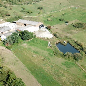
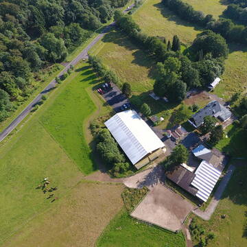
Box mit Vollpension und Weidegang
Elsoff
Familie Mücke
@Familie.Muecke
Freizeitstall
Pferdeausbildung
Vermieten
Krankenbox
Longierzirkel/Roundpen
Fohlenaufzucht möglich
Hufrehe geeignet
20 weitere...
P+
Deprecated: Creation of dynamic property Zend_View_Helper_Ads::$adLink is deprecated in /var/www/stall-frei/htdocs/staging.stall-frei.de/library/Psf/View/Helper/Ads.php on line 108

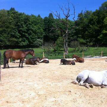
Gæðingaholt
Elsoff
Gaedingaholt
@Gaedingaholt
Freizeitstall
Gangpferdereiten
Vermieten
Hunde willkommen
Krankenbox
Allergikerstall
Hengsthaltung möglich
24 weitere...
P
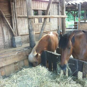
Bewegungsstall
Elsoff
B-Schuster
@B-Schuster
Freizeitstall
VFD-Mitglied
Vermieten
Krankenbox
Longierzirkel/Roundpen
Notfallboxen
16 weitere...
P


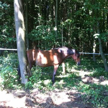
Reha/-Rentnerplätze Hufrehe - Offenstallanlage
Waldbrunn
Christopher-Heun
@Christopher-Heun
FN-Mitglied
Freizeitstall
Vermieten
Hunde willkommen
Krankenbox
Allergikerstall
Gnadenbrothof
30 weitere...
P+
Schweizerhof 3/4* LAG - Barhufstall - PaddockTrail
Westerburg
Sarah Lech
@Schweizerhof_Westerburg
Freizeitstall
Pferdeausbildung
Vermieten
Krankenbox
Paddock
Notfallboxen
13 weitere...
P+

Hof Gonsenborn - Offenstallplätze
Westerburg
Lisa Buhs
@LisaBuhs
Freizeitstall
VFD-Mitglied
Vermieten
Krankenbox
Longierzirkel/Roundpen
Gnadenbrothof
Hufrehe geeignet
20 weitere...
P

Mitarbeiter gesucht?
Mechtersen
STALL-FREIde Marketing
@STALL-FREI-Marketing
Stellenangebote kostenlos veröffentlichen!


Bewegungsstall in herrlichem Reitgelände u. Natur
Dornburg-Thalheim
Bewegungsstall-Hellersberghof
@Bewegungsstall-Hellersberghof
FN-Mitglied
Freizeitstall
Hunde willkommen
Krankenbox
Allergikerstall
bedampftes/gewaschenes Heu
Außenbox mit Paddock
Bewegungsstall
25 weitere...
aktuell
P+
Leider kein Vorschaubild
Leider kein Vorschaubild
Paddockboxen auf kleiner, familiären Anlage
Waldbrunn
Spitzberger Hof
@Spitzberger-Hof
FN-Mitglied
Freizeitstall
Vermieten
Hunde willkommen
Krankenbox
Fohlenaufzucht möglich
Notfallboxen
15 weitere...
P

Offenstallplatz
Breitscheid
Aktivstallfreunde
@Aktivstallfreunde
Freizeitstall
Hunde willkommen
Reitplatz (z.B. Dressur, Springen, Reining)
Bewegungsstall
Offenstall
Halbpension
Vollpension
6 weitere...
aktuell
P
Leider kein Vorschaubild
Leider kein Vorschaubild
Zucht- und Reitsportanlage Schultzenhof
Greifenstein Odersberg
Schultzenhof
@Schultzenhof
Freizeitstall
Geländestrecke
Vermieten
Hunde willkommen
Krankenbox
Fohlenaufzucht möglich
Hengsthaltung möglich
30 weitere...
B
Deprecated: Creation of dynamic property Zend_View::$pageCount is deprecated in /var/www/stall-frei/htdocs/staging.stall-frei.de/library/vendor/shardj/zf1-future/library/Zend/View/Abstract.php on line 308
Deprecated: Creation of dynamic property Zend_View::$itemCountPerPage is deprecated in /var/www/stall-frei/htdocs/staging.stall-frei.de/library/vendor/shardj/zf1-future/library/Zend/View/Abstract.php on line 308
Deprecated: Creation of dynamic property Zend_View::$first is deprecated in /var/www/stall-frei/htdocs/staging.stall-frei.de/library/vendor/shardj/zf1-future/library/Zend/View/Abstract.php on line 308
Deprecated: Creation of dynamic property Zend_View::$current is deprecated in /var/www/stall-frei/htdocs/staging.stall-frei.de/library/vendor/shardj/zf1-future/library/Zend/View/Abstract.php on line 308
Deprecated: Creation of dynamic property Zend_View::$last is deprecated in /var/www/stall-frei/htdocs/staging.stall-frei.de/library/vendor/shardj/zf1-future/library/Zend/View/Abstract.php on line 308
Deprecated: Creation of dynamic property Zend_View::$next is deprecated in /var/www/stall-frei/htdocs/staging.stall-frei.de/library/vendor/shardj/zf1-future/library/Zend/View/Abstract.php on line 308
Deprecated: Creation of dynamic property Zend_View::$pagesInRange is deprecated in /var/www/stall-frei/htdocs/staging.stall-frei.de/library/vendor/shardj/zf1-future/library/Zend/View/Abstract.php on line 308
Deprecated: Creation of dynamic property Zend_View::$firstPageInRange is deprecated in /var/www/stall-frei/htdocs/staging.stall-frei.de/library/vendor/shardj/zf1-future/library/Zend/View/Abstract.php on line 308
Deprecated: Creation of dynamic property Zend_View::$lastPageInRange is deprecated in /var/www/stall-frei/htdocs/staging.stall-frei.de/library/vendor/shardj/zf1-future/library/Zend/View/Abstract.php on line 308
Deprecated: Creation of dynamic property Zend_View::$currentItemCount is deprecated in /var/www/stall-frei/htdocs/staging.stall-frei.de/library/vendor/shardj/zf1-future/library/Zend/View/Abstract.php on line 308
Deprecated: Creation of dynamic property Zend_View::$totalItemCount is deprecated in /var/www/stall-frei/htdocs/staging.stall-frei.de/library/vendor/shardj/zf1-future/library/Zend/View/Abstract.php on line 308
Deprecated: Creation of dynamic property Zend_View::$firstItemNumber is deprecated in /var/www/stall-frei/htdocs/staging.stall-frei.de/library/vendor/shardj/zf1-future/library/Zend/View/Abstract.php on line 308
Deprecated: Creation of dynamic property Zend_View::$lastItemNumber is deprecated in /var/www/stall-frei/htdocs/staging.stall-frei.de/library/vendor/shardj/zf1-future/library/Zend/View/Abstract.php on line 308
Deprecated: Creation of dynamic property Zend_View::$router is deprecated in /var/www/stall-frei/htdocs/staging.stall-frei.de/library/vendor/shardj/zf1-future/library/Zend/View/Abstract.php on line 308
Deprecated: Creation of dynamic property Zend_View::$urlParams is deprecated in /var/www/stall-frei/htdocs/staging.stall-frei.de/library/vendor/shardj/zf1-future/library/Zend/View/Abstract.php on line 308
Deprecated: Creation of dynamic property Zend_View::$showAds is deprecated in /var/www/stall-frei/htdocs/staging.stall-frei.de/library/vendor/shardj/zf1-future/library/Zend/View/Abstract.php on line 308
Deprecated: Creation of dynamic property Zend_View::$objectIds is deprecated in /var/www/stall-frei/htdocs/staging.stall-frei.de/library/vendor/shardj/zf1-future/library/Zend/View/Abstract.php on line 308
Deprecated: Creation of dynamic property Zend_View::$showNavbar is deprecated in /var/www/stall-frei/htdocs/staging.stall-frei.de/library/vendor/shardj/zf1-future/library/Zend/View/Abstract.php on line 308
Deprecated: Creation of dynamic property Zend_View::$showBreadcrumb is deprecated in /var/www/stall-frei/htdocs/staging.stall-frei.de/library/vendor/shardj/zf1-future/library/Zend/View/Abstract.php on line 308
Deprecated: Creation of dynamic property Zend_View::$showFooter is deprecated in /var/www/stall-frei/htdocs/staging.stall-frei.de/library/vendor/shardj/zf1-future/library/Zend/View/Abstract.php on line 308
Deprecated: Creation of dynamic property Zend_View::$showInternalAds is deprecated in /var/www/stall-frei/htdocs/staging.stall-frei.de/library/vendor/shardj/zf1-future/library/Zend/View/Abstract.php on line 308
Deprecated: Creation of dynamic property Zend_View::$blNoContent is deprecated in /var/www/stall-frei/htdocs/staging.stall-frei.de/library/vendor/shardj/zf1-future/library/Zend/View/Abstract.php on line 308
Deprecated: Creation of dynamic property Zend_View::$sMetaDesc is deprecated in /var/www/stall-frei/htdocs/staging.stall-frei.de/library/vendor/shardj/zf1-future/library/Zend/View/Abstract.php on line 308
Deprecated: Creation of dynamic property Zend_View::$useGmaps is deprecated in /var/www/stall-frei/htdocs/staging.stall-frei.de/library/vendor/shardj/zf1-future/library/Zend/View/Abstract.php on line 308
Deprecated: Creation of dynamic property Zend_View::$touches is deprecated in /var/www/stall-frei/htdocs/staging.stall-frei.de/library/vendor/shardj/zf1-future/library/Zend/View/Abstract.php on line 308
Deprecated: Creation of dynamic property Zend_View::$oProject is deprecated in /var/www/stall-frei/htdocs/staging.stall-frei.de/library/vendor/shardj/zf1-future/library/Zend/View/Abstract.php on line 308
Deprecated: Creation of dynamic property Zend_View::$pageHeadline is deprecated in /var/www/stall-frei/htdocs/staging.stall-frei.de/library/vendor/shardj/zf1-future/library/Zend/View/Abstract.php on line 308
Deprecated: Creation of dynamic property Zend_View::$disableLocationField is deprecated in /var/www/stall-frei/htdocs/staging.stall-frei.de/library/vendor/shardj/zf1-future/library/Zend/View/Abstract.php on line 308
Deprecated: Creation of dynamic property Zend_View::$isSearch is deprecated in /var/www/stall-frei/htdocs/staging.stall-frei.de/library/vendor/shardj/zf1-future/library/Zend/View/Abstract.php on line 308
Deprecated: Creation of dynamic property Zend_View::$pageTitle is deprecated in /var/www/stall-frei/htdocs/staging.stall-frei.de/library/vendor/shardj/zf1-future/library/Zend/View/Abstract.php on line 308
Deprecated: Creation of dynamic property Psf_Form_Element_Text::$class is deprecated in /var/www/stall-frei/htdocs/staging.stall-frei.de/library/vendor/shardj/zf1-future/library/Zend/Form/Element.php on line 874
Deprecated: Creation of dynamic property Psf_Form_Element_Text::$size is deprecated in /var/www/stall-frei/htdocs/staging.stall-frei.de/library/vendor/shardj/zf1-future/library/Zend/Form/Element.php on line 874
Deprecated: Creation of dynamic property Psf_Form_Element_Text::$placeholder is deprecated in /var/www/stall-frei/htdocs/staging.stall-frei.de/library/vendor/shardj/zf1-future/library/Zend/Form/Element.php on line 874
Deprecated: Creation of dynamic property Psf_Form_Element_Hidden::$class is deprecated in /var/www/stall-frei/htdocs/staging.stall-frei.de/library/vendor/shardj/zf1-future/library/Zend/Form/Element.php on line 874
Deprecated: Creation of dynamic property Psf_Form_Element_Hidden::$class is deprecated in /var/www/stall-frei/htdocs/staging.stall-frei.de/library/vendor/shardj/zf1-future/library/Zend/Form/Element.php on line 874
Deprecated: Creation of dynamic property Psf_Form_Element_Hidden::$class is deprecated in /var/www/stall-frei/htdocs/staging.stall-frei.de/library/vendor/shardj/zf1-future/library/Zend/Form/Element.php on line 874
Deprecated: Creation of dynamic property Psf_Form_Element_Hidden::$class is deprecated in /var/www/stall-frei/htdocs/staging.stall-frei.de/library/vendor/shardj/zf1-future/library/Zend/Form/Element.php on line 874
Deprecated: Creation of dynamic property Psf_Form_Element_Select::$class is deprecated in /var/www/stall-frei/htdocs/staging.stall-frei.de/library/vendor/shardj/zf1-future/library/Zend/Form/Element.php on line 874
Deprecated: Creation of dynamic property Psf_Form_Element_Select::$class is deprecated in /var/www/stall-frei/htdocs/staging.stall-frei.de/library/vendor/shardj/zf1-future/library/Zend/Form/Element.php on line 874
Deprecated: Creation of dynamic property Psf_Form_Element_Select::$class is deprecated in /var/www/stall-frei/htdocs/staging.stall-frei.de/library/vendor/shardj/zf1-future/library/Zend/Form/Element.php on line 874
Deprecated: Creation of dynamic property Psf_Form_Element_Select::$class is deprecated in /var/www/stall-frei/htdocs/staging.stall-frei.de/library/vendor/shardj/zf1-future/library/Zend/Form/Element.php on line 874
Deprecated: Creation of dynamic property Psf_Form_Element_Text::$class is deprecated in /var/www/stall-frei/htdocs/staging.stall-frei.de/library/vendor/shardj/zf1-future/library/Zend/Form/Element.php on line 874
Deprecated: Creation of dynamic property Psf_Form_Element_Checkbox::$label is deprecated in /var/www/stall-frei/htdocs/staging.stall-frei.de/library/vendor/shardj/zf1-future/library/Zend/Form/Element.php on line 874
Deprecated: Creation of dynamic property Zend_View::$sort is deprecated in /var/www/stall-frei/htdocs/staging.stall-frei.de/library/vendor/shardj/zf1-future/library/Zend/View/Abstract.php on line 308
Deprecated: Creation of dynamic property Zend_View::$searchLocation is deprecated in /var/www/stall-frei/htdocs/staging.stall-frei.de/library/vendor/shardj/zf1-future/library/Zend/View/Abstract.php on line 308
Deprecated: Creation of dynamic property Zend_View::$locationHint is deprecated in /var/www/stall-frei/htdocs/staging.stall-frei.de/library/vendor/shardj/zf1-future/library/Zend/View/Abstract.php on line 308
Psf_GeoCoder_Abstract::getLocation: Oberrod Get Location CachedOrLive
Psf_GeoCoder_Abstract::getCachedOrLive: Oberrod
Psf_GeoCoder_OpenCageData::makeApiRequest: response:
Array
(
[documentation] => https://opencagedata.com/api
[licenses] => Array
(
[0] => Array
(
[name] => see attribution guide
[url] => https://opencagedata.com/credits
)
)
[results] => Array
(
[0] => Array
(
[bounds] => Array
(
[northeast] => Array
(
[lat] => 50.6091621
[lng] => 8.1522888
)
[southwest] => Array
(
[lat] => 50.5761527
[lng] => 8.1104134
)
)
[components] => Array
(
[ISO_3166-1_alpha-2] => DE
[ISO_3166-1_alpha-3] => DEU
[ISO_3166-2] => Array
(
[0] => DE-RP
)
[_category] => place
[_normalized_city] => Oberrod
[_type] => village
[continent] => Europe
[country] => Deutschland
[country_code] => de
[county] => Westerwaldkreis
[municipality] => Rennerod
[political_union] => European Union
[state] => Rheinland-Pfalz
[state_code] => RP
[village] => Oberrod
)
[confidence] => 7
[formatted] => Oberrod, Rheinland-Pfalz, Deutschland
[geometry] => Array
(
[lat] => 50.5849515
[lng] => 8.1250934
)
)
[1] => Array
(
[bounds] => Array
(
[northeast] => Array
(
[lat] => 50.5063358
[lng] => 10.8258244
)
[southwest] => Array
(
[lat] => 50.4663358
[lng] => 10.7858244
)
)
[components] => Array
(
[ISO_3166-1_alpha-2] => DE
[ISO_3166-1_alpha-3] => DEU
[ISO_3166-2] => Array
(
[0] => DE-TH
)
[_category] => place
[_normalized_city] => Oberrod
[_type] => village
[continent] => Europe
[country] => Deutschland
[country_code] => de
[county] => Landkreis Hildburghausen
[municipality] => Schleusingen
[political_union] => European Union
[state] => Thüringen
[state_code] => TH
[village] => Oberrod
)
[confidence] => 7
[formatted] => Oberrod, Thüringen, Deutschland
[geometry] => Array
(
[lat] => 50.4863358
[lng] => 10.8058244
)
)
[2] => Array
(
[components] => Array
(
[ISO_3166-1_alpha-2] => FR
[ISO_3166-1_alpha-3] => FRA
[ISO_3166-2] => Array
(
[0] => FR-ARA
[1] => FR-26
)
[_category] => road
[_normalized_city] => Montvendre
[_type] => road
[city] => Montvendre
[continent] => Europe
[country] => France
[country_code] => fr
[county] => Drôme
[local_authority] => Valence Romans Agglo
[political_union] => European Union
[postcode] => 26120
[road] => Route de l'Oberie
[state] => Auvergne-Rhône-Alpes
[state_code] => ARA
)
[confidence] => 2
[formatted] => Route de l'Oberie, 26120 Montvendre, France
[geometry] => Array
(
[lat] => 44.869388
[lng] => 5.006863
)
)
[3] => Array
(
[components] => Array
(
[ISO_3166-1_alpha-2] => FR
[ISO_3166-1_alpha-3] => FRA
[ISO_3166-2] => Array
(
[0] => FR-ARA
[1] => FR-03
)
[_category] => road
[_normalized_city] => Deneuille-les-Mines
[_type] => road
[city] => Deneuille-les-Mines
[continent] => Europe
[country] => France
[country_code] => fr
[county] => Allier
[local_authority] => Commentry Montmarault Néris Communauté
[political_union] => European Union
[postcode] => 03170
[road] => Rue des Aberots
[state] => Auvergne-Rhône-Alpes
[state_code] => ARA
)
[confidence] => 2
[formatted] => Rue des Aberots, 03170 Deneuille-les-Mines, France
[geometry] => Array
(
[lat] => 46.3845
[lng] => 2.778295
)
)
[4] => Array
(
[components] => Array
(
[ISO_3166-1_alpha-2] => FR
[ISO_3166-1_alpha-3] => FRA
[ISO_3166-2] => Array
(
[0] => FR-NOR
[1] => FR-14
)
[_category] => road
[_normalized_city] => Leffard
[_type] => road
[city] => Leffard
[continent] => Europe
[country] => France
[country_code] => fr
[county] => Calvados
[local_authority] => Communauté de communes du Pays de Falaise
[political_union] => European Union
[postcode] => 14700
[road] => Rue de la Hoberie
[state] => Normandie
[state_code] => NOR
)
[confidence] => 2
[formatted] => Rue de la Hoberie, 14700 Leffard, France
[geometry] => Array
(
[lat] => 48.9292
[lng] => -0.309054
)
)
[5] => Array
(
[components] => Array
(
[ISO_3166-1_alpha-2] => YT
[ISO_3166-1_alpha-3] => MYT
[ISO_3166-2] => Array
(
[0] => FR-976
)
[_category] => road
[_normalized_city] => Mtsamboro
[_type] => road
[city] => Mtsamboro
[continent] => Africa
[country] => France
[country_code] => fr
[county] => Mayotte
[local_authority] => Communauté d'agglomération du Grand Nord de Mayotte
[political_union] => European Union
[postcode] => 97630
[road] => Chemin Daday Obera
[state] =>
)
[confidence] => 2
[formatted] => Chemin Daday Obera, 97630 Mtsamboro, France
[geometry] => Array
(
[lat] => -12.688916
[lng] => 45.075897
)
)
[6] => Array
(
[components] => Array
(
[ISO_3166-1_alpha-2] => FR
[ISO_3166-1_alpha-3] => FRA
[ISO_3166-2] => Array
(
[0] => FR-PDL
[1] => FR-53
)
[_category] => road
[_normalized_city] => Saint-Mars-sur-la-Futaie
[_type] => road
[city] => Saint-Mars-sur-la-Futaie
[continent] => Europe
[country] => France
[country_code] => fr
[county] => Mayenne
[local_authority] => Communauté de communes du Bocage Mayennais
[political_union] => European Union
[postcode] => 53220
[road] => Impasse de la Hoberie
[state] => Pays de la Loire
[state_code] => PDL
)
[confidence] => 10
[formatted] => Impasse de la Hoberie, 53220 Saint-Mars-sur-la-Futaie, France
[geometry] => Array
(
[lat] => 48.436594
[lng] => -1.048446
)
)
[7] => Array
(
[components] => Array
(
[ISO_3166-1_alpha-2] => FR
[ISO_3166-1_alpha-3] => FRA
[ISO_3166-2] => Array
(
[0] => FR-CVL
[1] => FR-37
)
[_category] => road
[_normalized_city] => Fondettes
[_type] => road
[city] => Fondettes
[continent] => Europe
[country] => France
[country_code] => fr
[county] => Indre-et-Loire
[local_authority] => Tours Métropole Val de Loire
[political_union] => European Union
[postcode] => 37230
[road] => Rue Claire Oberge-Sanzay
[state] => Centre-Val de Loire
[state_code] => CVL
)
[confidence] => 10
[formatted] => Rue Claire Oberge-Sanzay, 37230 Fondettes, France
[geometry] => Array
(
[lat] => 47.409663
[lng] => 0.592703
)
)
[8] => Array
(
[components] => Array
(
[ISO_3166-1_alpha-2] => FR
[ISO_3166-1_alpha-3] => FRA
[ISO_3166-2] => Array
(
[0] => FR-GES
[1] => FR-6AE
[2] => FR-68
)
[_category] => road
[_normalized_city] => Kappelen
[_type] => road
[city] => Kappelen
[continent] => Europe
[country] => France
[country_code] => fr
[county] => Haut-Rhin
[local_authority] => Saint-Louis Agglomération
[political_union] => European Union
[postcode] => 68510
[road] => Rue Oberried
[state] => Grand Est
[state_code] => GES
)
[confidence] => 10
[formatted] => Rue Oberried, 68510 Kappelen, France
[geometry] => Array
(
[lat] => 47.611226
[lng] => 7.436022
)
)
[9] => Array
(
[components] => Array
(
[ISO_3166-1_alpha-2] => FR
[ISO_3166-1_alpha-3] => FRA
[ISO_3166-2] => Array
(
[0] => FR-GES
[1] => FR-6AE
[2] => FR-68
)
[_category] => road
[_normalized_city] => Colmar
[_type] => road
[city] => Colmar
[continent] => Europe
[country] => France
[country_code] => fr
[county] => Haut-Rhin
[local_authority] => Colmar Agglomération
[political_union] => European Union
[postcode] => 68000
[road] => Oberhoh-Weg
[state] => Grand Est
[state_code] => GES
)
[confidence] => 10
[formatted] => Oberhoh-Weg, 68000 Colmar, France
[geometry] => Array
(
[lat] => 48.065681
[lng] => 7.365303
)
)
)
[status] => Array
(
[code] => 200
[message] => OK
)
[stay_informed] => Array
(
[blog] => https://blog.opencagedata.com
[mastodon] => https://en.osm.town/@opencage
)
[thanks] => For using an OpenCage API
[timestamp] => Array
(
[created_http] => Sun, 08 Feb 2026 12:07:30 GMT
[created_unix] => 1770552450
)
[total_results] => 10
)
Psf_GeoCoder_Abstract::convertLocationResult
{"documentation":"https:\/\/opencagedata.com\/api","licenses":[{"name":"see attribution guide","url":"https:\/\/opencagedata.com\/credits"}],"results":[{"bounds":{"northeast":{"lat":50.6091621,"lng":8.1522888},"southwest":{"lat":50.5761527,"lng":8.1104134}},"components":{"ISO_3166-1_alpha-2":"DE","ISO_3166-1_alpha-3":"DEU","ISO_3166-2":["DE-RP"],"_category":"place","_normalized_city":"Oberrod","_type":"village","continent":"Europe","country":"Deutschland","country_code":"de","county":"Westerwaldkreis","municipality":"Rennerod","political_union":"European Union","state":"Rheinland-Pfalz","state_code":"RP","village":"Oberrod"},"confidence":7,"formatted":"Oberrod, Rheinland-Pfalz, Deutschland","geometry":{"lat":50.5849515,"lng":8.1250934}},{"bounds":{"northeast":{"lat":50.5063358,"lng":10.8258244},"southwest":{"lat":50.4663358,"lng":10.7858244}},"components":{"ISO_3166-1_alpha-2":"DE","ISO_3166-1_alpha-3":"DEU","ISO_3166-2":["DE-TH"],"_category":"place","_normalized_city":"Oberrod","_type":"village","continent":"Europe","country":"Deutschland","country_code":"de","county":"Landkreis Hildburghausen","municipality":"Schleusingen","political_union":"European Union","state":"Th\u00fcringen","state_code":"TH","village":"Oberrod"},"confidence":7,"formatted":"Oberrod, Th\u00fcringen, Deutschland","geometry":{"lat":50.4863358,"lng":10.8058244}},{"components":{"ISO_3166-1_alpha-2":"FR","ISO_3166-1_alpha-3":"FRA","ISO_3166-2":["FR-ARA","FR-26"],"_category":"road","_normalized_city":"Montvendre","_type":"road","city":"Montvendre","continent":"Europe","country":"France","country_code":"fr","county":"Dr\u00f4me","local_authority":"Valence Romans Agglo","political_union":"European Union","postcode":"26120","road":"Route de l'Oberie","state":"Auvergne-Rh\u00f4ne-Alpes","state_code":"ARA"},"confidence":2,"formatted":"Route de l'Oberie, 26120 Montvendre, France","geometry":{"lat":44.869388,"lng":5.006863}},{"components":{"ISO_3166-1_alpha-2":"FR","ISO_3166-1_alpha-3":"FRA","ISO_3166-2":["FR-ARA","FR-03"],"_category":"road","_normalized_city":"Deneuille-les-Mines","_type":"road","city":"Deneuille-les-Mines","continent":"Europe","country":"France","country_code":"fr","county":"Allier","local_authority":"Commentry Montmarault N\u00e9ris Communaut\u00e9","political_union":"European Union","postcode":"03170","road":"Rue des Aberots","state":"Auvergne-Rh\u00f4ne-Alpes","state_code":"ARA"},"confidence":2,"formatted":"Rue des Aberots, 03170 Deneuille-les-Mines, France","geometry":{"lat":46.3845,"lng":2.778295}},{"components":{"ISO_3166-1_alpha-2":"FR","ISO_3166-1_alpha-3":"FRA","ISO_3166-2":["FR-NOR","FR-14"],"_category":"road","_normalized_city":"Leffard","_type":"road","city":"Leffard","continent":"Europe","country":"France","country_code":"fr","county":"Calvados","local_authority":"Communaut\u00e9 de communes du Pays de Falaise","political_union":"European Union","postcode":"14700","road":"Rue de la Hoberie","state":"Normandie","state_code":"NOR"},"confidence":2,"formatted":"Rue de la Hoberie, 14700 Leffard, France","geometry":{"lat":48.9292,"lng":-0.309054}},{"components":{"ISO_3166-1_alpha-2":"YT","ISO_3166-1_alpha-3":"MYT","ISO_3166-2":["FR-976"],"_category":"road","_normalized_city":"Mtsamboro","_type":"road","city":"Mtsamboro","continent":"Africa","country":"France","country_code":"fr","county":"Mayotte","local_authority":"Communaut\u00e9 d'agglom\u00e9ration du Grand Nord de Mayotte","political_union":"European Union","postcode":"97630","road":"Chemin Daday Obera","state":null},"confidence":2,"formatted":"Chemin Daday Obera, 97630 Mtsamboro, France","geometry":{"lat":-12.688916,"lng":45.075897}},{"components":{"ISO_3166-1_alpha-2":"FR","ISO_3166-1_alpha-3":"FRA","ISO_3166-2":["FR-PDL","FR-53"],"_category":"road","_normalized_city":"Saint-Mars-sur-la-Futaie","_type":"road","city":"Saint-Mars-sur-la-Futaie","continent":"Europe","country":"France","country_code":"fr","county":"Mayenne","local_authority":"Communaut\u00e9 de communes du Bocage Mayennais","political_union":"European Union","postcode":"53220","road":"Impasse de la Hoberie","state":"Pays de la Loire","state_code":"PDL"},"confidence":10,"formatted":"Impasse de la Hoberie, 53220 Saint-Mars-sur-la-Futaie, France","geometry":{"lat":48.436594,"lng":-1.048446}},{"components":{"ISO_3166-1_alpha-2":"FR","ISO_3166-1_alpha-3":"FRA","ISO_3166-2":["FR-CVL","FR-37"],"_category":"road","_normalized_city":"Fondettes","_type":"road","city":"Fondettes","continent":"Europe","country":"France","country_code":"fr","county":"Indre-et-Loire","local_authority":"Tours M\u00e9tropole Val de Loire","political_union":"European Union","postcode":"37230","road":"Rue Claire Oberge-Sanzay","state":"Centre-Val de Loire","state_code":"CVL"},"confidence":10,"formatted":"Rue Claire Oberge-Sanzay, 37230 Fondettes, France","geometry":{"lat":47.409663,"lng":0.592703}},{"components":{"ISO_3166-1_alpha-2":"FR","ISO_3166-1_alpha-3":"FRA","ISO_3166-2":["FR-GES","FR-6AE","FR-68"],"_category":"road","_normalized_city":"Kappelen","_type":"road","city":"Kappelen","continent":"Europe","country":"France","country_code":"fr","county":"Haut-Rhin","local_authority":"Saint-Louis Agglom\u00e9ration","political_union":"European Union","postcode":"68510","road":"Rue Oberried","state":"Grand Est","state_code":"GES"},"confidence":10,"formatted":"Rue Oberried, 68510 Kappelen, France","geometry":{"lat":47.611226,"lng":7.436022}},{"components":{"ISO_3166-1_alpha-2":"FR","ISO_3166-1_alpha-3":"FRA","ISO_3166-2":["FR-GES","FR-6AE","FR-68"],"_category":"road","_normalized_city":"Colmar","_type":"road","city":"Colmar","continent":"Europe","country":"France","country_code":"fr","county":"Haut-Rhin","local_authority":"Colmar Agglom\u00e9ration","political_union":"European Union","postcode":"68000","road":"Oberhoh-Weg","state":"Grand Est","state_code":"GES"},"confidence":10,"formatted":"Oberhoh-Weg, 68000 Colmar, France","geometry":{"lat":48.065681,"lng":7.365303}}],"status":{"code":200,"message":"OK"},"stay_informed":{"blog":"https:\/\/blog.opencagedata.com","mastodon":"https:\/\/en.osm.town\/@opencage"},"thanks":"For using an OpenCage API","timestamp":{"created_http":"Sun, 08 Feb 2026 12:07:30 GMT","created_unix":1770552450},"total_results":10}Array
(
[0] => stdClass Object
(
[bounds] => stdClass Object
(
[northeast] => stdClass Object
(
[lat] => 50.6091621
[lng] => 8.1522888
)
[southwest] => stdClass Object
(
[lat] => 50.5761527
[lng] => 8.1104134
)
)
[components] => stdClass Object
(
[ISO_3166-1_alpha-2] => DE
[ISO_3166-1_alpha-3] => DEU
[ISO_3166-2] => Array
(
[0] => DE-RP
)
[_category] => place
[_normalized_city] => Oberrod
[_type] => village
[continent] => Europe
[country] => Deutschland
[country_code] => de
[county] => Westerwaldkreis
[municipality] => Rennerod
[political_union] => European Union
[state] => Rheinland-Pfalz
[state_code] => RP
[village] => Oberrod
)
[confidence] => 7
[formatted] => Oberrod, Rheinland-Pfalz, Deutschland
[geometry] => stdClass Object
(
[lat] => 50.5849515
[lng] => 8.1250934
)
)
[1] => stdClass Object
(
[bounds] => stdClass Object
(
[northeast] => stdClass Object
(
[lat] => 50.5063358
[lng] => 10.8258244
)
[southwest] => stdClass Object
(
[lat] => 50.4663358
[lng] => 10.7858244
)
)
[components] => stdClass Object
(
[ISO_3166-1_alpha-2] => DE
[ISO_3166-1_alpha-3] => DEU
[ISO_3166-2] => Array
(
[0] => DE-TH
)
[_category] => place
[_normalized_city] => Oberrod
[_type] => village
[continent] => Europe
[country] => Deutschland
[country_code] => de
[county] => Landkreis Hildburghausen
[municipality] => Schleusingen
[political_union] => European Union
[state] => Thüringen
[state_code] => TH
[village] => Oberrod
)
[confidence] => 7
[formatted] => Oberrod, Thüringen, Deutschland
[geometry] => stdClass Object
(
[lat] => 50.4863358
[lng] => 10.8058244
)
)
[2] => stdClass Object
(
[components] => stdClass Object
(
[ISO_3166-1_alpha-2] => FR
[ISO_3166-1_alpha-3] => FRA
[ISO_3166-2] => Array
(
[0] => FR-ARA
[1] => FR-26
)
[_category] => road
[_normalized_city] => Montvendre
[_type] => road
[city] => Montvendre
[continent] => Europe
[country] => France
[country_code] => fr
[county] => Drôme
[local_authority] => Valence Romans Agglo
[political_union] => European Union
[postcode] => 26120
[road] => Route de l'Oberie
[state] => Auvergne-Rhône-Alpes
[state_code] => ARA
)
[confidence] => 2
[formatted] => Route de l'Oberie, 26120 Montvendre, France
[geometry] => stdClass Object
(
[lat] => 44.869388
[lng] => 5.006863
)
)
[3] => stdClass Object
(
[components] => stdClass Object
(
[ISO_3166-1_alpha-2] => FR
[ISO_3166-1_alpha-3] => FRA
[ISO_3166-2] => Array
(
[0] => FR-ARA
[1] => FR-03
)
[_category] => road
[_normalized_city] => Deneuille-les-Mines
[_type] => road
[city] => Deneuille-les-Mines
[continent] => Europe
[country] => France
[country_code] => fr
[county] => Allier
[local_authority] => Commentry Montmarault Néris Communauté
[political_union] => European Union
[postcode] => 03170
[road] => Rue des Aberots
[state] => Auvergne-Rhône-Alpes
[state_code] => ARA
)
[confidence] => 2
[formatted] => Rue des Aberots, 03170 Deneuille-les-Mines, France
[geometry] => stdClass Object
(
[lat] => 46.3845
[lng] => 2.778295
)
)
[4] => stdClass Object
(
[components] => stdClass Object
(
[ISO_3166-1_alpha-2] => FR
[ISO_3166-1_alpha-3] => FRA
[ISO_3166-2] => Array
(
[0] => FR-NOR
[1] => FR-14
)
[_category] => road
[_normalized_city] => Leffard
[_type] => road
[city] => Leffard
[continent] => Europe
[country] => France
[country_code] => fr
[county] => Calvados
[local_authority] => Communauté de communes du Pays de Falaise
[political_union] => European Union
[postcode] => 14700
[road] => Rue de la Hoberie
[state] => Normandie
[state_code] => NOR
)
[confidence] => 2
[formatted] => Rue de la Hoberie, 14700 Leffard, France
[geometry] => stdClass Object
(
[lat] => 48.9292
[lng] => -0.309054
)
)
[5] => stdClass Object
(
[components] => stdClass Object
(
[ISO_3166-1_alpha-2] => YT
[ISO_3166-1_alpha-3] => MYT
[ISO_3166-2] => Array
(
[0] => FR-976
)
[_category] => road
[_normalized_city] => Mtsamboro
[_type] => road
[city] => Mtsamboro
[continent] => Africa
[country] => France
[country_code] => fr
[county] => Mayotte
[local_authority] => Communauté d'agglomération du Grand Nord de Mayotte
[political_union] => European Union
[postcode] => 97630
[road] => Chemin Daday Obera
[state] =>
)
[confidence] => 2
[formatted] => Chemin Daday Obera, 97630 Mtsamboro, France
[geometry] => stdClass Object
(
[lat] => -12.688916
[lng] => 45.075897
)
)
[6] => stdClass Object
(
[components] => stdClass Object
(
[ISO_3166-1_alpha-2] => FR
[ISO_3166-1_alpha-3] => FRA
[ISO_3166-2] => Array
(
[0] => FR-PDL
[1] => FR-53
)
[_category] => road
[_normalized_city] => Saint-Mars-sur-la-Futaie
[_type] => road
[city] => Saint-Mars-sur-la-Futaie
[continent] => Europe
[country] => France
[country_code] => fr
[county] => Mayenne
[local_authority] => Communauté de communes du Bocage Mayennais
[political_union] => European Union
[postcode] => 53220
[road] => Impasse de la Hoberie
[state] => Pays de la Loire
[state_code] => PDL
)
[confidence] => 10
[formatted] => Impasse de la Hoberie, 53220 Saint-Mars-sur-la-Futaie, France
[geometry] => stdClass Object
(
[lat] => 48.436594
[lng] => -1.048446
)
)
[7] => stdClass Object
(
[components] => stdClass Object
(
[ISO_3166-1_alpha-2] => FR
[ISO_3166-1_alpha-3] => FRA
[ISO_3166-2] => Array
(
[0] => FR-CVL
[1] => FR-37
)
[_category] => road
[_normalized_city] => Fondettes
[_type] => road
[city] => Fondettes
[continent] => Europe
[country] => France
[country_code] => fr
[county] => Indre-et-Loire
[local_authority] => Tours Métropole Val de Loire
[political_union] => European Union
[postcode] => 37230
[road] => Rue Claire Oberge-Sanzay
[state] => Centre-Val de Loire
[state_code] => CVL
)
[confidence] => 10
[formatted] => Rue Claire Oberge-Sanzay, 37230 Fondettes, France
[geometry] => stdClass Object
(
[lat] => 47.409663
[lng] => 0.592703
)
)
[8] => stdClass Object
(
[components] => stdClass Object
(
[ISO_3166-1_alpha-2] => FR
[ISO_3166-1_alpha-3] => FRA
[ISO_3166-2] => Array
(
[0] => FR-GES
[1] => FR-6AE
[2] => FR-68
)
[_category] => road
[_normalized_city] => Kappelen
[_type] => road
[city] => Kappelen
[continent] => Europe
[country] => France
[country_code] => fr
[county] => Haut-Rhin
[local_authority] => Saint-Louis Agglomération
[political_union] => European Union
[postcode] => 68510
[road] => Rue Oberried
[state] => Grand Est
[state_code] => GES
)
[confidence] => 10
[formatted] => Rue Oberried, 68510 Kappelen, France
[geometry] => stdClass Object
(
[lat] => 47.611226
[lng] => 7.436022
)
)
[9] => stdClass Object
(
[components] => stdClass Object
(
[ISO_3166-1_alpha-2] => FR
[ISO_3166-1_alpha-3] => FRA
[ISO_3166-2] => Array
(
[0] => FR-GES
[1] => FR-6AE
[2] => FR-68
)
[_category] => road
[_normalized_city] => Colmar
[_type] => road
[city] => Colmar
[continent] => Europe
[country] => France
[country_code] => fr
[county] => Haut-Rhin
[local_authority] => Colmar Agglomération
[political_union] => European Union
[postcode] => 68000
[road] => Oberhoh-Weg
[state] => Grand Est
[state_code] => GES
)
[confidence] => 10
[formatted] => Oberhoh-Weg, 68000 Colmar, France
[geometry] => stdClass Object
(
[lat] => 48.065681
[lng] => 7.365303
)
)
)
Psf_GeoCoder_OpenCageData::getKeyMap: 0
stdClass Object
(
    [bounds] => stdClass Object
        (
            [northeast] => stdClass Object
                (
                    [lat] => 50.6091621
                    [lng] => 8.1522888
                )

            [southwest] => stdClass Object
                (
                    [lat] => 50.5761527
                    [lng] => 8.1104134
                )

        )

    [components] => stdClass Object
        (
            [ISO_3166-1_alpha-2] => DE
            [ISO_3166-1_alpha-3] => DEU
            [ISO_3166-2] => Array
                (
                    [0] => DE-RP
                )

            [_category] => place
            [_normalized_city] => Oberrod
            [_type] => village
            [continent] => Europe
            [country] => Deutschland
            [country_code] => de
            [county] => Westerwaldkreis
            [municipality] => Rennerod
            [political_union] => European Union
            [state] => Rheinland-Pfalz
            [state_code] => RP
            [village] => Oberrod
        )

    [confidence] => 7
    [formatted] => Oberrod, Rheinland-Pfalz, Deutschland
    [geometry] => stdClass Object
        (
            [lat] => 50.5849515
            [lng] => 8.1250934
        )

)
Psf_GeoCoder_OpenCageData::getCounty: Westerwaldkreis
Psf_GeoCoder_OpenCageData::addMissingData REFETCH!
Array
(
    [address] => Oberrod, Rheinland-Pfalz, Deutschland
    [type] => village
    [street] =>
    [city] => Oberrod
    [county] => Westerwaldkreis
    [state] => Rheinland-Pfalz
    [zip] =>
    [country] => Deutschland
    [suburb] =>
    [countrycode] => de
    [latitude] => 50.5849515
    [longitude] => 8.1250934
    [accuracy] => 1
    [confidence] => 7
    [bounds] => stdClass Object
        (
            [northeast] => stdClass Object
                (
                    [lat] => 50.6091621
                    [lng] => 8.1522888
                )

            [southwest] => stdClass Object
                (
                    [lat] => 50.5761527
                    [lng] => 8.1104134
                )

        )

)
reformat!
Array
(
    [address] => Oberrod, Rheinland-Pfalz, Deutschland
    [type] => village
    [street] =>
    [city] => Oberrod
    [county] => Westerwaldkreis
    [state] => Rheinland-Pfalz
    [zip] =>
    [country] => Deutschland
    [suburb] =>
    [countrycode] => de
    [latitude] => 50.5849515
    [longitude] => 8.1250934
    [accuracy] => 1
    [confidence] => 7
    [bounds] => stdClass Object
        (
            [northeast] => stdClass Object
                (
                    [lat] => 50.6091621
                    [lng] => 8.1522888
                )

            [southwest] => stdClass Object
                (
                    [lat] => 50.5761527
                    [lng] => 8.1104134
                )

        )

    [place] => Oberrod, Rheinland-Pfalz
    [hash] => b3beb61a2eb9eae41924cdee769565dc
)
Psf_GeoCoder_OpenCageData::getKeyMap: 1
stdClass Object
(
    [bounds] => stdClass Object
        (
            [northeast] => stdClass Object
                (
                    [lat] => 50.5063358
                    [lng] => 10.8258244
                )

            [southwest] => stdClass Object
                (
                    [lat] => 50.4663358
                    [lng] => 10.7858244
                )

        )

    [components] => stdClass Object
        (
            [ISO_3166-1_alpha-2] => DE
            [ISO_3166-1_alpha-3] => DEU
            [ISO_3166-2] => Array
                (
                    [0] => DE-TH
                )

            [_category] => place
            [_normalized_city] => Oberrod
            [_type] => village
            [continent] => Europe
            [country] => Deutschland
            [country_code] => de
            [county] => Landkreis Hildburghausen
            [municipality] => Schleusingen
            [political_union] => European Union
            [state] => Thüringen
            [state_code] => TH
            [village] => Oberrod
        )

    [confidence] => 7
    [formatted] => Oberrod, Thüringen, Deutschland
    [geometry] => stdClass Object
        (
            [lat] => 50.4863358
            [lng] => 10.8058244
        )

)
Psf_GeoCoder_OpenCageData::getCounty: Hildburghausen
Psf_GeoCoder_OpenCageData::addMissingData REFETCH!
Array
(
    [address] => Oberrod, Thüringen, Deutschland
    [type] => village
    [street] =>
    [city] => Oberrod
    [county] => Hildburghausen
    [state] => Thüringen
    [zip] =>
    [country] => Deutschland
    [suburb] =>
    [countrycode] => de
    [latitude] => 50.4863358
    [longitude] => 10.8058244
    [accuracy] => 1
    [confidence] => 7
    [bounds] => stdClass Object
        (
            [northeast] => stdClass Object
                (
                    [lat] => 50.5063358
                    [lng] => 10.8258244
                )

            [southwest] => stdClass Object
                (
                    [lat] => 50.4663358
                    [lng] => 10.7858244
                )

        )

)
reformat!
Array
(
    [address] => Oberrod, Thüringen, Deutschland
    [type] => village
    [street] =>
    [city] => Oberrod
    [county] => Hildburghausen
    [state] => Thüringen
    [zip] =>
    [country] => Deutschland
    [suburb] =>
    [countrycode] => de
    [latitude] => 50.4863358
    [longitude] => 10.8058244
    [accuracy] => 1
    [confidence] => 7
    [bounds] => stdClass Object
        (
            [northeast] => stdClass Object
                (
                    [lat] => 50.5063358
                    [lng] => 10.8258244
                )

            [southwest] => stdClass Object
                (
                    [lat] => 50.4663358
                    [lng] => 10.7858244
                )

        )

    [place] => Oberrod, Thüringen
    [hash] => 7ae0743f13f1855e703033251c2d203b
)
Psf_GeoCoder_OpenCageData::getKeyMap: 2
stdClass Object
(
    [components] => stdClass Object
        (
            [ISO_3166-1_alpha-2] => FR
            [ISO_3166-1_alpha-3] => FRA
            [ISO_3166-2] => Array
                (
                    [0] => FR-ARA
                    [1] => FR-26
                )

            [_category] => road
            [_normalized_city] => Montvendre
            [_type] => road
            [city] => Montvendre
            [continent] => Europe
            [country] => France
            [country_code] => fr
            [county] => Drôme
            [local_authority] => Valence Romans Agglo
            [political_union] => European Union
            [postcode] => 26120
            [road] => Route de l'Oberie
            [state] => Auvergne-Rhône-Alpes
            [state_code] => ARA
        )

    [confidence] => 2
    [formatted] => Route de l'Oberie, 26120 Montvendre, France
    [geometry] => stdClass Object
        (
            [lat] => 44.869388
            [lng] => 5.006863
        )

)
Psf_GeoCoder_OpenCageData::getCounty: Drôme
Psf_GeoCoder_OpenCageData::addMissingData REFETCH!
Array
(
    [address] => Route de l'Oberie, 26120 Montvendre, France
    [type] => road
    [street] => Route de l'Oberie
    [city] => Montvendre
    [county] => Drôme
    [state] => Auvergne-Rhône-Alpes
    [zip] => 26120
    [country] => France
    [suburb] =>
    [countrycode] => fr
    [latitude] => 44.869388
    [longitude] => 5.006863
    [accuracy] => 1
    [confidence] => 2
    [bounds] =>
)
reformat!
Array
(
    [address] => Route de l'Oberie, 26120 Montvendre, France
    [type] => road
    [street] => Route de l'Oberie
    [city] => Montvendre
    [county] => Drôme
    [state] => Auvergne-Rhône-Alpes
    [zip] => 26120
    [country] => France
    [suburb] =>
    [countrycode] => fr
    [latitude] => 44.869388
    [longitude] => 5.006863
    [accuracy] => 1
    [confidence] => 2
    [bounds] =>
    [place] => Route de l'Oberie, 26120 Montvendre, Auvergne-Rhône-Alpes
    [hash] => 642261eabf890a9c63196168bf88b3da
)
Psf_GeoCoder_OpenCageData::getKeyMap: 3
stdClass Object
(
    [components] => stdClass Object
        (
            [ISO_3166-1_alpha-2] => FR
            [ISO_3166-1_alpha-3] => FRA
            [ISO_3166-2] => Array
                (
                    [0] => FR-ARA
                    [1] => FR-03
                )

            [_category] => road
            [_normalized_city] => Deneuille-les-Mines
            [_type] => road
            [city] => Deneuille-les-Mines
            [continent] => Europe
            [country] => France
            [country_code] => fr
            [county] => Allier
            [local_authority] => Commentry Montmarault Néris Communauté
            [political_union] => European Union
            [postcode] => 03170
            [road] => Rue des Aberots
            [state] => Auvergne-Rhône-Alpes
            [state_code] => ARA
        )

    [confidence] => 2
    [formatted] => Rue des Aberots, 03170 Deneuille-les-Mines, France
    [geometry] => stdClass Object
        (
            [lat] => 46.3845
            [lng] => 2.778295
        )

)
Psf_GeoCoder_OpenCageData::getCounty: Allier
Psf_GeoCoder_OpenCageData::addMissingData REFETCH!
Array
(
    [address] => Rue des Aberots, 03170 Deneuille-les-Mines, France
    [type] => road
    [street] => Rue des Aberots
    [city] => Deneuille-les-Mines
    [county] => Allier
    [state] => Auvergne-Rhône-Alpes
    [zip] => 03170
    [country] => France
    [suburb] =>
    [countrycode] => fr
    [latitude] => 46.3845
    [longitude] => 2.778295
    [accuracy] => 1
    [confidence] => 2
    [bounds] =>
)
reformat!
Array
(
    [address] => Rue des Aberots, 03170 Deneuille-les-Mines, France
    [type] => road
    [street] => Rue des Aberots
    [city] => Deneuille-les-Mines
    [county] => Allier
    [state] => Auvergne-Rhône-Alpes
    [zip] => 03170
    [country] => France
    [suburb] =>
    [countrycode] => fr
    [latitude] => 46.3845
    [longitude] => 2.778295
    [accuracy] => 1
    [confidence] => 2
    [bounds] =>
    [place] => Rue des Aberots, 03170 Deneuille-les-Mines, Auvergne-Rhône-Alpes
    [hash] => 25d864e62f3289f4067a697d423213fa
)
Psf_GeoCoder_OpenCageData::getKeyMap: 4
stdClass Object
(
    [components] => stdClass Object
        (
            [ISO_3166-1_alpha-2] => FR
            [ISO_3166-1_alpha-3] => FRA
            [ISO_3166-2] => Array
                (
                    [0] => FR-NOR
                    [1] => FR-14
                )

            [_category] => road
            [_normalized_city] => Leffard
            [_type] => road
            [city] => Leffard
            [continent] => Europe
            [country] => France
            [country_code] => fr
            [county] => Calvados
            [local_authority] => Communauté de communes du Pays de Falaise
            [political_union] => European Union
            [postcode] => 14700
            [road] => Rue de la Hoberie
            [state] => Normandie
            [state_code] => NOR
        )

    [confidence] => 2
    [formatted] => Rue de la Hoberie, 14700 Leffard, France
    [geometry] => stdClass Object
        (
            [lat] => 48.9292
            [lng] => -0.309054
        )

)
Psf_GeoCoder_OpenCageData::getCounty: Calvados
Psf_GeoCoder_OpenCageData::addMissingData REFETCH!
Array
(
    [address] => Rue de la Hoberie, 14700 Leffard, France
    [type] => road
    [street] => Rue de la Hoberie
    [city] => Leffard
    [county] => Calvados
    [state] => Normandie
    [zip] => 14700
    [country] => France
    [suburb] =>
    [countrycode] => fr
    [latitude] => 48.9292
    [longitude] => -0.309054
    [accuracy] => 1
    [confidence] => 2
    [bounds] =>
)
reformat!
Array
(
    [address] => Rue de la Hoberie, 14700 Leffard, France
    [type] => road
    [street] => Rue de la Hoberie
    [city] => Leffard
    [county] => Calvados
    [state] => Normandie
    [zip] => 14700
    [country] => France
    [suburb] =>
    [countrycode] => fr
    [latitude] => 48.9292
    [longitude] => -0.309054
    [accuracy] => 1
    [confidence] => 2
    [bounds] =>
    [place] => Rue de la Hoberie, 14700 Leffard, Normandie
    [hash] => 13ee84ebe21b28fcaec07d37dd2506bc
)
Psf_GeoCoder_OpenCageData::getKeyMap: 5
stdClass Object
(
    [components] => stdClass Object
        (
            [ISO_3166-1_alpha-2] => YT
            [ISO_3166-1_alpha-3] => MYT
            [ISO_3166-2] => Array
                (
                    [0] => FR-976
                )

            [_category] => road
            [_normalized_city] => Mtsamboro
            [_type] => road
            [city] => Mtsamboro
            [continent] => Africa
            [country] => France
            [country_code] => fr
            [county] => Mayotte
            [local_authority] => Communauté d'agglomération du Grand Nord de Mayotte
            [political_union] => European Union
            [postcode] => 97630
            [road] => Chemin Daday Obera
            [state] =>
        )

    [confidence] => 2
    [formatted] => Chemin Daday Obera, 97630 Mtsamboro, France
    [geometry] => stdClass Object
        (
            [lat] => -12.688916
            [lng] => 45.075897
        )

)
Psf_GeoCoder_OpenCageData::getCounty: Mayotte
Psf_GeoCoder_OpenCageData::addMissingData REFETCH!
Array
(
    [address] => Chemin Daday Obera, 97630 Mtsamboro, France
    [type] => road
    [street] => Chemin Daday Obera
    [city] => Mtsamboro
    [county] => Mayotte
    [state] =>
    [zip] => 97630
    [country] => France
    [suburb] =>
    [countrycode] => fr
    [latitude] => -12.688916
    [longitude] => 45.075897
    [accuracy] => 1
    [confidence] => 2
    [bounds] =>
)
reformat!
Array
(
    [address] => Chemin Daday Obera, 97630 Mtsamboro, France
    [type] => road
    [street] => Chemin Daday Obera
    [city] => Mtsamboro
    [county] => Mayotte
    [state] =>
    [zip] => 97630
    [country] => France
    [suburb] =>
    [countrycode] => fr
    [latitude] => -12.688916
    [longitude] => 45.075897
    [accuracy] => 1
    [confidence] => 2
    [bounds] =>
    [place] => Chemin Daday Obera, 97630 Mtsamboro, France
    [hash] => 952914d8eb3cd435408d25afef9468ee
)
Psf_GeoCoder_OpenCageData::getKeyMap: 6
stdClass Object
(
    [components] => stdClass Object
        (
            [ISO_3166-1_alpha-2] => FR
            [ISO_3166-1_alpha-3] => FRA
            [ISO_3166-2] => Array
                (
                    [0] => FR-PDL
                    [1] => FR-53
                )

            [_category] => road
            [_normalized_city] => Saint-Mars-sur-la-Futaie
            [_type] => road
            [city] => Saint-Mars-sur-la-Futaie
            [continent] => Europe
            [country] => France
            [country_code] => fr
            [county] => Mayenne
            [local_authority] => Communauté de communes du Bocage Mayennais
            [political_union] => European Union
            [postcode] => 53220
            [road] => Impasse de la Hoberie
            [state] => Pays de la Loire
            [state_code] => PDL
        )

    [confidence] => 10
    [formatted] => Impasse de la Hoberie, 53220 Saint-Mars-sur-la-Futaie, France
    [geometry] => stdClass Object
        (
            [lat] => 48.436594
            [lng] => -1.048446
        )

)
Psf_GeoCoder_OpenCageData::getCounty: Mayenne
Psf_GeoCoder_OpenCageData::addMissingData REFETCH!
Array
(
    [address] => Impasse de la Hoberie, 53220 Saint-Mars-sur-la-Futaie, France
    [type] => road
    [street] => Impasse de la Hoberie
    [city] => Saint-Mars-sur-la-Futaie
    [county] => Mayenne
    [state] => Pays de la Loire
    [zip] => 53220
    [country] => France
    [suburb] =>
    [countrycode] => fr
    [latitude] => 48.436594
    [longitude] => -1.048446
    [accuracy] => 1
    [confidence] => 10
    [bounds] =>
)
reformat!
Array
(
    [address] => Impasse de la Hoberie, 53220 Saint-Mars-sur-la-Futaie, France
    [type] => road
    [street] => Impasse de la Hoberie
    [city] => Saint-Mars-sur-la-Futaie
    [county] => Mayenne
    [state] => Pays de la Loire
    [zip] => 53220
    [country] => France
    [suburb] =>
    [countrycode] => fr
    [latitude] => 48.436594
    [longitude] => -1.048446
    [accuracy] => 1
    [confidence] => 10
    [bounds] =>
    [place] => Impasse de la Hoberie, 53220 Saint-Mars-sur-la-Futaie, Pays de la Loire
    [hash] => d2e9579d1e4d24d1c7437837b31287e3
)
Psf_GeoCoder_OpenCageData::getKeyMap: 7
stdClass Object
(
    [components] => stdClass Object
        (
            [ISO_3166-1_alpha-2] => FR
            [ISO_3166-1_alpha-3] => FRA
            [ISO_3166-2] => Array
                (
                    [0] => FR-CVL
                    [1] => FR-37
                )

            [_category] => road
            [_normalized_city] => Fondettes
            [_type] => road
            [city] => Fondettes
            [continent] => Europe
            [country] => France
            [country_code] => fr
            [county] => Indre-et-Loire
            [local_authority] => Tours Métropole Val de Loire
            [political_union] => European Union
            [postcode] => 37230
            [road] => Rue Claire Oberge-Sanzay
            [state] => Centre-Val de Loire
            [state_code] => CVL
        )

    [confidence] => 10
    [formatted] => Rue Claire Oberge-Sanzay, 37230 Fondettes, France
    [geometry] => stdClass Object
        (
            [lat] => 47.409663
            [lng] => 0.592703
        )

)
Psf_GeoCoder_OpenCageData::getCounty: Indre-et-Loire
Psf_GeoCoder_OpenCageData::addMissingData REFETCH!
Array
(
    [address] => Rue Claire Oberge-Sanzay, 37230 Fondettes, France
    [type] => road
    [street] => Rue Claire Oberge-Sanzay
    [city] => Fondettes
    [county] => Indre-et-Loire
    [state] => Centre-Val de Loire
    [zip] => 37230
    [country] => France
    [suburb] =>
    [countrycode] => fr
    [latitude] => 47.409663
    [longitude] => 0.592703
    [accuracy] => 1
    [confidence] => 10
    [bounds] =>
)
reformat!
Array
(
    [address] => Rue Claire Oberge-Sanzay, 37230 Fondettes, France
    [type] => road
    [street] => Rue Claire Oberge-Sanzay
    [city] => Fondettes
    [county] => Indre-et-Loire
    [state] => Centre-Val de Loire
    [zip] => 37230
    [country] => France
    [suburb] =>
    [countrycode] => fr
    [latitude] => 47.409663
    [longitude] => 0.592703
    [accuracy] => 1
    [confidence] => 10
    [bounds] =>
    [place] => Rue Claire Oberge-Sanzay, 37230 Fondettes, Centre-Val de Loire
    [hash] => 9d1e397f7c2ff81e585147998cd5a2cf
)
Psf_GeoCoder_OpenCageData::getKeyMap: 8
stdClass Object
(
    [components] => stdClass Object
        (
            [ISO_3166-1_alpha-2] => FR
            [ISO_3166-1_alpha-3] => FRA
            [ISO_3166-2] => Array
                (
                    [0] => FR-GES
                    [1] => FR-6AE
                    [2] => FR-68
                )

            [_category] => road
            [_normalized_city] => Kappelen
            [_type] => road
            [city] => Kappelen
            [continent] => Europe
            [country] => France
            [country_code] => fr
            [county] => Haut-Rhin
            [local_authority] => Saint-Louis Agglomération
            [political_union] => European Union
            [postcode] => 68510
            [road] => Rue Oberried
            [state] => Grand Est
            [state_code] => GES
        )

    [confidence] => 10
    [formatted] => Rue Oberried, 68510 Kappelen, France
    [geometry] => stdClass Object
        (
            [lat] => 47.611226
            [lng] => 7.436022
        )

)
Psf_GeoCoder_OpenCageData::getCounty: Haut-Rhin
Psf_GeoCoder_OpenCageData::addMissingData REFETCH!
Array
(
    [address] => Rue Oberried, 68510 Kappelen, France
    [type] => road
    [street] => Rue Oberried
    [city] => Kappelen
    [county] => Haut-Rhin
    [state] => Grand Est
    [zip] => 68510
    [country] => France
    [suburb] =>
    [countrycode] => fr
    [latitude] => 47.611226
    [longitude] => 7.436022
    [accuracy] => 1
    [confidence] => 10
    [bounds] =>
)
reformat!
Array
(
    [address] => Rue Oberried, 68510 Kappelen, France
    [type] => road
    [street] => Rue Oberried
    [city] => Kappelen
    [county] => Haut-Rhin
    [state] => Grand Est
    [zip] => 68510
    [country] => France
    [suburb] =>
    [countrycode] => fr
    [latitude] => 47.611226
    [longitude] => 7.436022
    [accuracy] => 1
    [confidence] => 10
    [bounds] =>
    [place] => Rue Oberried, 68510 Kappelen, Grand Est
    [hash] => 2461a65103dad1eab86068c01a6d9fd4
)
Psf_GeoCoder_OpenCageData::getKeyMap: 9
stdClass Object
(
    [components] => stdClass Object
        (
            [ISO_3166-1_alpha-2] => FR
            [ISO_3166-1_alpha-3] => FRA
            [ISO_3166-2] => Array
                (
                    [0] => FR-GES
                    [1] => FR-6AE
                    [2] => FR-68
                )

            [_category] => road
            [_normalized_city] => Colmar
            [_type] => road
            [city] => Colmar
            [continent] => Europe
            [country] => France
            [country_code] => fr
            [county] => Haut-Rhin
            [local_authority] => Colmar Agglomération
            [political_union] => European Union
            [postcode] => 68000
            [road] => Oberhoh-Weg
            [state] => Grand Est
            [state_code] => GES
        )

    [confidence] => 10
    [formatted] => Oberhoh-Weg, 68000 Colmar, France
    [geometry] => stdClass Object
        (
            [lat] => 48.065681
            [lng] => 7.365303
        )

)
Psf_GeoCoder_OpenCageData::getCounty: Haut-Rhin
Psf_GeoCoder_OpenCageData::addMissingData REFETCH!
Array
(
    [address] => Oberhoh-Weg, 68000 Colmar, France
    [type] => road
    [street] => Oberhoh-Weg
    [city] => Colmar
    [county] => Haut-Rhin
    [state] => Grand Est
    [zip] => 68000
    [country] => France
    [suburb] =>
    [countrycode] => fr
    [latitude] => 48.065681
    [longitude] => 7.365303
    [accuracy] => 1
    [confidence] => 10
    [bounds] =>
)
reformat!
Array
(
    [address] => Oberhoh-Weg, 68000 Colmar, France
    [type] => road
    [street] => Oberhoh-Weg
    [city] => Colmar
    [county] => Haut-Rhin
    [state] => Grand Est
    [zip] => 68000
    [country] => France
    [suburb] =>
    [countrycode] => fr
    [latitude] => 48.065681
    [longitude] => 7.365303
    [accuracy] => 1
    [confidence] => 10
    [bounds] =>
    [place] => Oberhoh-Weg, 68000 Colmar, Grand Est
    [hash] => 3a83369846706d4907100be854a6e274
)
Deprecated: Creation of dynamic property Zend_View::$locationHintStyle is deprecated in /var/www/stall-frei/htdocs/staging.stall-frei.de/library/vendor/shardj/zf1-future/library/Zend/View/Abstract.php on line 308
Deprecated: Creation of dynamic property Zend_View::$adGeoLocation is deprecated in /var/www/stall-frei/htdocs/staging.stall-frei.de/library/vendor/shardj/zf1-future/library/Zend/View/Abstract.php on line 308
Deprecated: Creation of dynamic property Zend_View::$recordCount is deprecated in /var/www/stall-frei/htdocs/staging.stall-frei.de/library/vendor/shardj/zf1-future/library/Zend/View/Abstract.php on line 308
Deprecated: explode(): Passing null to parameter #2 ($string) of type string is deprecated in /var/www/stall-frei/htdocs/staging.stall-frei.de/application/models/SearchAgent.php on line 100
Deprecated: explode(): Passing null to parameter #2 ($string) of type string is deprecated in /var/www/stall-frei/htdocs/staging.stall-frei.de/application/models/SearchAgent.php on line 100
Deprecated: explode(): Passing null to parameter #2 ($string) of type string is deprecated in /var/www/stall-frei/htdocs/staging.stall-frei.de/application/models/SearchAgent.php on line 100
Deprecated: explode(): Passing null to parameter #2 ($string) of type string is deprecated in /var/www/stall-frei/htdocs/staging.stall-frei.de/application/models/SearchAgent.php on line 100
Deprecated: explode(): Passing null to parameter #2 ($string) of type string is deprecated in /var/www/stall-frei/htdocs/staging.stall-frei.de/application/models/SearchAgent.php on line 100
Deprecated: explode(): Passing null to parameter #2 ($string) of type string is deprecated in /var/www/stall-frei/htdocs/staging.stall-frei.de/application/models/SearchAgent.php on line 100
Deprecated: explode(): Passing null to parameter #2 ($string) of type string is deprecated in /var/www/stall-frei/htdocs/staging.stall-frei.de/application/models/SearchAgent.php on line 100
Deprecated: explode(): Passing null to parameter #2 ($string) of type string is deprecated in /var/www/stall-frei/htdocs/staging.stall-frei.de/application/models/SearchAgent.php on line 100
Deprecated: explode(): Passing null to parameter #2 ($string) of type string is deprecated in /var/www/stall-frei/htdocs/staging.stall-frei.de/application/models/SearchAgent.php on line 100
Deprecated: trim(): Passing null to parameter #1 ($string) of type string is deprecated in /var/www/stall-frei/htdocs/staging.stall-frei.de/application/models/Account/Search.php on line 82
Warning: Cannot modify header information - headers already sent by (output started at /var/www/stall-frei/htdocs/staging.stall-frei.de/library/vendor/shardj/zf1-future/library/Zend/View/Abstract.php:308) in /var/www/stall-frei/htdocs/staging.stall-frei.de/application/models/Account/Search.php on line 71
Deprecated: Creation of dynamic property Zend_View::$paginationParams is deprecated in /var/www/stall-frei/htdocs/staging.stall-frei.de/library/vendor/shardj/zf1-future/library/Zend/View/Abstract.php on line 308
Deprecated: Creation of dynamic property Zend_View::$objectPaginator is deprecated in /var/www/stall-frei/htdocs/staging.stall-frei.de/library/vendor/shardj/zf1-future/library/Zend/View/Abstract.php on line 308
Deprecated: Creation of dynamic property Zend_View::$featuredObjects is deprecated in /var/www/stall-frei/htdocs/staging.stall-frei.de/library/vendor/shardj/zf1-future/library/Zend/View/Abstract.php on line 308
Deprecated: Creation of dynamic property Zend_View::$hints is deprecated in /var/www/stall-frei/htdocs/staging.stall-frei.de/library/vendor/shardj/zf1-future/library/Zend/View/Abstract.php on line 308
Deprecated: Creation of dynamic property Zend_View::$attributeHints is deprecated in /var/www/stall-frei/htdocs/staging.stall-frei.de/library/vendor/shardj/zf1-future/library/Zend/View/Abstract.php on line 308
Deprecated: Creation of dynamic property Zend_View::$oSearchForm is deprecated in /var/www/stall-frei/htdocs/staging.stall-frei.de/library/vendor/shardj/zf1-future/library/Zend/View/Abstract.php on line 308