Deprecated: Creation of dynamic property Zend_View::$sMode is deprecated in /var/www/stall-frei/htdocs/staging.stall-frei.de/library/vendor/shardj/zf1-future/library/Zend/View/Abstract.php on line 308
Stallplatz oder Offenstall in Rohrberg (Altmark)
Gesucht wird in "Rohrberg (Altmark), Sachsen-Anhalt, Deutschland"
6.328 Einträge
Deprecated: Creation of dynamic property Zend_View::$listObjects is deprecated in /var/www/stall-frei/htdocs/staging.stall-frei.de/library/vendor/shardj/zf1-future/library/Zend/View/Abstract.php on line 308
Gesponsort


Deprecated: Creation of dynamic property Zend_View::$listMode is deprecated in /var/www/stall-frei/htdocs/staging.stall-frei.de/library/vendor/shardj/zf1-future/library/Zend/View/Abstract.php on line 308
Deprecated: Creation of dynamic property Zend_View::$renderedObjects is deprecated in /var/www/stall-frei/htdocs/staging.stall-frei.de/library/vendor/shardj/zf1-future/library/Zend/View/Abstract.php on line 308
Deprecated: Creation of dynamic property Zend_View::$index is deprecated in /var/www/stall-frei/htdocs/staging.stall-frei.de/library/vendor/shardj/zf1-future/library/Zend/View/Abstract.php on line 308
Deprecated: Creation of dynamic property Zend_View::$displayMode is deprecated in /var/www/stall-frei/htdocs/staging.stall-frei.de/library/vendor/shardj/zf1-future/library/Zend/View/Abstract.php on line 308
Deprecated: Creation of dynamic property Zend_View::$remarketingIds is deprecated in /var/www/stall-frei/htdocs/staging.stall-frei.de/library/vendor/shardj/zf1-future/library/Zend/View/Abstract.php on line 308
Deprecated: Creation of dynamic property Zend_View::$listItem is deprecated in /var/www/stall-frei/htdocs/staging.stall-frei.de/library/vendor/shardj/zf1-future/library/Zend/View/Abstract.php on line 308
Deprecated: Creation of dynamic property Zend_View::$object is deprecated in /var/www/stall-frei/htdocs/staging.stall-frei.de/library/vendor/shardj/zf1-future/library/Zend/View/Abstract.php on line 308
Deprecated: Creation of dynamic property Zend_View::$attributes is deprecated in /var/www/stall-frei/htdocs/staging.stall-frei.de/library/vendor/shardj/zf1-future/library/Zend/View/Abstract.php on line 308

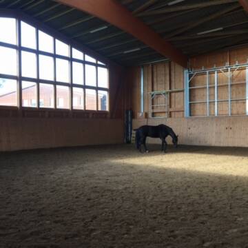
Selbstvers. od. HP,Stallgasse,Offenstall,Box frei
Wittingen OT Schneflingen
Gut Schneflingen
@Gut-Schneflingen
Freizeitstall
Vermieten
Verpachten
Longierzirkel/Roundpen
Parkplatz für Pferdeanhänger
Außenbox mit Paddock
Außenboxen
15 weitere...
P
Deprecated: Creation of dynamic property Zend_View_Helper_Ads::$adLink is deprecated in /var/www/stall-frei/htdocs/staging.stall-frei.de/library/Psf/View/Helper/Ads.php on line 108

Heu und Heulage verkaufen
Mechtersen
STALL-FREIde Marketing
@STALL-FREI-Marketing
Verkaufen Sie Ihr Heu und Ihre Heulage direkt an Reiter, Pferdeställe und Reitanlagen
Leider kein Vorschaubild
Leider kein Vorschaubild
Offenstall / auch für Allergiker geeignet
Flecken Apenburg winterfeld
Anja Liermann
@A.Liermann
VFD-Mitglied
Krankenbox
Longierzirkel/Roundpen
Allergikerstall
bedampftes/gewaschenes Heu
Bewegungsstall
Laufstall
9 weitere...
B
Leider kein Vorschaubild
Leider kein Vorschaubild
artgerechter Offenstall, Offenstallplatz frei
Wittingen/Ohrdorf
Bettina-Meissner
@Bettina-Meissner
Freizeitstall
Geländestrecke
Vermieten
Hunde willkommen
Longierzirkel/Roundpen
Allergikerstall
8 weitere...
B
Leider kein Vorschaubild
Leider kein Vorschaubild
Selbstversorgerplätze oder HP auf Reitanlage frei
Wittingen
Gut Schneflingen
@Gut-Schneflingen
Freizeitstall
Vermieten
Verpachten
Krankenbox
Longierzirkel/Roundpen
Außenbox mit Paddock
Außenboxen
19 weitere...
B
Leider kein Vorschaubild
Leider kein Vorschaubild
Offenstallplatz frei
Wittingen
Pferdepension
@MonaBeyer
Geländestrecke
Pferdeausbildung
Krankenbox
Longierzirkel/Roundpen
Allergikerstall
Fohlenaufzucht möglich
Offenstall
13 weitere...
B

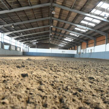
Neu gebaute Boxen frei & 2 große Außenbo...
Soltendieck OT Bockholt
Familie Harr
@KarinshofHarr
Vermieten
Krankenbox
Longierzirkel/Roundpen
Allergikerstall
bedampftes/gewaschenes Heu
Außenbox mit Paddock
Außenboxen
20 weitere...
P
Leider kein Vorschaubild
Leider kein Vorschaubild
Offenstall frei für Wallach/ Hengst / Asthma Pfe...
Schnega
Mareike
@Mareike07
Geländestrecke
Hunde willkommen
Krankenbox
Allergikerstall
bedampftes/gewaschenes Heu
Außenboxen
Offenstall
15 weitere...
B
Pferdeboxen Reitanlage mit großen Wiesen
Brechtorf
Reitstall Hoppe Brechtorf
@Hoppe
Reitlehrer und -unterricht
Longierzirkel/Roundpen
Paddock
Außenbox mit Paddock
Vollpension
11 weitere...
P

Frisches Stroh zu verkaufen!
Mechtersen
STALL-FREIde Marketing
@STALL-FREI-Marketing
Kaufe frisches Stroh für dein Pferd!
Leider kein Vorschaubild
Leider kein Vorschaubild
5* Offenstall, Allergiker geeignet, Einsteller
Knesebeck
Lisa Krawehl
@Lisa1993
Freizeitstall
Hunde willkommen
Krankenbox
Allergikerstall
Notfallboxen
Bewegungsstall
Laufstall
14 weitere...
B
freie Einstellplätze
Tiddische
Weidenhof-GAUS-GmbH
@Weidenhof-GAUS-GmbH
Freizeitstall
Pferdeausbildung
Vermieten
Führanlage
Longierzirkel/Roundpen
Außenboxen
Innenbox
12 weitere...
P
Deprecated: Creation of dynamic property Zend_View::$pageCount is deprecated in /var/www/stall-frei/htdocs/staging.stall-frei.de/library/vendor/shardj/zf1-future/library/Zend/View/Abstract.php on line 308
Deprecated: Creation of dynamic property Zend_View::$itemCountPerPage is deprecated in /var/www/stall-frei/htdocs/staging.stall-frei.de/library/vendor/shardj/zf1-future/library/Zend/View/Abstract.php on line 308
Deprecated: Creation of dynamic property Zend_View::$first is deprecated in /var/www/stall-frei/htdocs/staging.stall-frei.de/library/vendor/shardj/zf1-future/library/Zend/View/Abstract.php on line 308
Deprecated: Creation of dynamic property Zend_View::$current is deprecated in /var/www/stall-frei/htdocs/staging.stall-frei.de/library/vendor/shardj/zf1-future/library/Zend/View/Abstract.php on line 308
Deprecated: Creation of dynamic property Zend_View::$last is deprecated in /var/www/stall-frei/htdocs/staging.stall-frei.de/library/vendor/shardj/zf1-future/library/Zend/View/Abstract.php on line 308
Deprecated: Creation of dynamic property Zend_View::$next is deprecated in /var/www/stall-frei/htdocs/staging.stall-frei.de/library/vendor/shardj/zf1-future/library/Zend/View/Abstract.php on line 308
Deprecated: Creation of dynamic property Zend_View::$pagesInRange is deprecated in /var/www/stall-frei/htdocs/staging.stall-frei.de/library/vendor/shardj/zf1-future/library/Zend/View/Abstract.php on line 308
Deprecated: Creation of dynamic property Zend_View::$firstPageInRange is deprecated in /var/www/stall-frei/htdocs/staging.stall-frei.de/library/vendor/shardj/zf1-future/library/Zend/View/Abstract.php on line 308
Deprecated: Creation of dynamic property Zend_View::$lastPageInRange is deprecated in /var/www/stall-frei/htdocs/staging.stall-frei.de/library/vendor/shardj/zf1-future/library/Zend/View/Abstract.php on line 308
Deprecated: Creation of dynamic property Zend_View::$currentItemCount is deprecated in /var/www/stall-frei/htdocs/staging.stall-frei.de/library/vendor/shardj/zf1-future/library/Zend/View/Abstract.php on line 308
Deprecated: Creation of dynamic property Zend_View::$totalItemCount is deprecated in /var/www/stall-frei/htdocs/staging.stall-frei.de/library/vendor/shardj/zf1-future/library/Zend/View/Abstract.php on line 308
Deprecated: Creation of dynamic property Zend_View::$firstItemNumber is deprecated in /var/www/stall-frei/htdocs/staging.stall-frei.de/library/vendor/shardj/zf1-future/library/Zend/View/Abstract.php on line 308
Deprecated: Creation of dynamic property Zend_View::$lastItemNumber is deprecated in /var/www/stall-frei/htdocs/staging.stall-frei.de/library/vendor/shardj/zf1-future/library/Zend/View/Abstract.php on line 308
Deprecated: Creation of dynamic property Zend_View::$router is deprecated in /var/www/stall-frei/htdocs/staging.stall-frei.de/library/vendor/shardj/zf1-future/library/Zend/View/Abstract.php on line 308
Deprecated: Creation of dynamic property Zend_View::$urlParams is deprecated in /var/www/stall-frei/htdocs/staging.stall-frei.de/library/vendor/shardj/zf1-future/library/Zend/View/Abstract.php on line 308
Deprecated: Creation of dynamic property Zend_View::$showAds is deprecated in /var/www/stall-frei/htdocs/staging.stall-frei.de/library/vendor/shardj/zf1-future/library/Zend/View/Abstract.php on line 308
Deprecated: Creation of dynamic property Zend_View::$objectIds is deprecated in /var/www/stall-frei/htdocs/staging.stall-frei.de/library/vendor/shardj/zf1-future/library/Zend/View/Abstract.php on line 308
Deprecated: Creation of dynamic property Zend_View::$showNavbar is deprecated in /var/www/stall-frei/htdocs/staging.stall-frei.de/library/vendor/shardj/zf1-future/library/Zend/View/Abstract.php on line 308
Deprecated: Creation of dynamic property Zend_View::$showBreadcrumb is deprecated in /var/www/stall-frei/htdocs/staging.stall-frei.de/library/vendor/shardj/zf1-future/library/Zend/View/Abstract.php on line 308
Deprecated: Creation of dynamic property Zend_View::$showFooter is deprecated in /var/www/stall-frei/htdocs/staging.stall-frei.de/library/vendor/shardj/zf1-future/library/Zend/View/Abstract.php on line 308
Deprecated: Creation of dynamic property Zend_View::$showInternalAds is deprecated in /var/www/stall-frei/htdocs/staging.stall-frei.de/library/vendor/shardj/zf1-future/library/Zend/View/Abstract.php on line 308
Deprecated: Creation of dynamic property Zend_View::$blNoContent is deprecated in /var/www/stall-frei/htdocs/staging.stall-frei.de/library/vendor/shardj/zf1-future/library/Zend/View/Abstract.php on line 308
Deprecated: Creation of dynamic property Zend_View::$sMetaDesc is deprecated in /var/www/stall-frei/htdocs/staging.stall-frei.de/library/vendor/shardj/zf1-future/library/Zend/View/Abstract.php on line 308
Deprecated: Creation of dynamic property Zend_View::$useGmaps is deprecated in /var/www/stall-frei/htdocs/staging.stall-frei.de/library/vendor/shardj/zf1-future/library/Zend/View/Abstract.php on line 308
Deprecated: Creation of dynamic property Zend_View::$touches is deprecated in /var/www/stall-frei/htdocs/staging.stall-frei.de/library/vendor/shardj/zf1-future/library/Zend/View/Abstract.php on line 308
Deprecated: Creation of dynamic property Zend_View::$oProject is deprecated in /var/www/stall-frei/htdocs/staging.stall-frei.de/library/vendor/shardj/zf1-future/library/Zend/View/Abstract.php on line 308
Deprecated: Creation of dynamic property Zend_View::$pageHeadline is deprecated in /var/www/stall-frei/htdocs/staging.stall-frei.de/library/vendor/shardj/zf1-future/library/Zend/View/Abstract.php on line 308
Deprecated: Creation of dynamic property Zend_View::$disableLocationField is deprecated in /var/www/stall-frei/htdocs/staging.stall-frei.de/library/vendor/shardj/zf1-future/library/Zend/View/Abstract.php on line 308
Deprecated: Creation of dynamic property Zend_View::$isSearch is deprecated in /var/www/stall-frei/htdocs/staging.stall-frei.de/library/vendor/shardj/zf1-future/library/Zend/View/Abstract.php on line 308
Deprecated: Creation of dynamic property Zend_View::$pageTitle is deprecated in /var/www/stall-frei/htdocs/staging.stall-frei.de/library/vendor/shardj/zf1-future/library/Zend/View/Abstract.php on line 308
Deprecated: Creation of dynamic property Psf_Form_Element_Text::$class is deprecated in /var/www/stall-frei/htdocs/staging.stall-frei.de/library/vendor/shardj/zf1-future/library/Zend/Form/Element.php on line 874
Deprecated: Creation of dynamic property Psf_Form_Element_Text::$size is deprecated in /var/www/stall-frei/htdocs/staging.stall-frei.de/library/vendor/shardj/zf1-future/library/Zend/Form/Element.php on line 874
Deprecated: Creation of dynamic property Psf_Form_Element_Text::$placeholder is deprecated in /var/www/stall-frei/htdocs/staging.stall-frei.de/library/vendor/shardj/zf1-future/library/Zend/Form/Element.php on line 874
Deprecated: Creation of dynamic property Psf_Form_Element_Hidden::$class is deprecated in /var/www/stall-frei/htdocs/staging.stall-frei.de/library/vendor/shardj/zf1-future/library/Zend/Form/Element.php on line 874
Deprecated: Creation of dynamic property Psf_Form_Element_Hidden::$class is deprecated in /var/www/stall-frei/htdocs/staging.stall-frei.de/library/vendor/shardj/zf1-future/library/Zend/Form/Element.php on line 874
Deprecated: Creation of dynamic property Psf_Form_Element_Hidden::$class is deprecated in /var/www/stall-frei/htdocs/staging.stall-frei.de/library/vendor/shardj/zf1-future/library/Zend/Form/Element.php on line 874
Deprecated: Creation of dynamic property Psf_Form_Element_Hidden::$class is deprecated in /var/www/stall-frei/htdocs/staging.stall-frei.de/library/vendor/shardj/zf1-future/library/Zend/Form/Element.php on line 874
Deprecated: Creation of dynamic property Psf_Form_Element_Select::$class is deprecated in /var/www/stall-frei/htdocs/staging.stall-frei.de/library/vendor/shardj/zf1-future/library/Zend/Form/Element.php on line 874
Deprecated: Creation of dynamic property Psf_Form_Element_Select::$class is deprecated in /var/www/stall-frei/htdocs/staging.stall-frei.de/library/vendor/shardj/zf1-future/library/Zend/Form/Element.php on line 874
Deprecated: Creation of dynamic property Psf_Form_Element_Select::$class is deprecated in /var/www/stall-frei/htdocs/staging.stall-frei.de/library/vendor/shardj/zf1-future/library/Zend/Form/Element.php on line 874
Deprecated: Creation of dynamic property Psf_Form_Element_Select::$class is deprecated in /var/www/stall-frei/htdocs/staging.stall-frei.de/library/vendor/shardj/zf1-future/library/Zend/Form/Element.php on line 874
Deprecated: Creation of dynamic property Psf_Form_Element_Text::$class is deprecated in /var/www/stall-frei/htdocs/staging.stall-frei.de/library/vendor/shardj/zf1-future/library/Zend/Form/Element.php on line 874
Deprecated: Creation of dynamic property Psf_Form_Element_Checkbox::$label is deprecated in /var/www/stall-frei/htdocs/staging.stall-frei.de/library/vendor/shardj/zf1-future/library/Zend/Form/Element.php on line 874
Deprecated: Creation of dynamic property Zend_View::$sort is deprecated in /var/www/stall-frei/htdocs/staging.stall-frei.de/library/vendor/shardj/zf1-future/library/Zend/View/Abstract.php on line 308
Deprecated: Creation of dynamic property Zend_View::$searchLocation is deprecated in /var/www/stall-frei/htdocs/staging.stall-frei.de/library/vendor/shardj/zf1-future/library/Zend/View/Abstract.php on line 308
Deprecated: Creation of dynamic property Zend_View::$locationHint is deprecated in /var/www/stall-frei/htdocs/staging.stall-frei.de/library/vendor/shardj/zf1-future/library/Zend/View/Abstract.php on line 308
Psf_GeoCoder_Abstract::getLocation: Rohrberg (Altmark) Get Location CachedOrLive
Psf_GeoCoder_Abstract::getCachedOrLive: Rohrberg (Altmark)
Psf_GeoCoder_OpenCageData::makeApiRequest: response:
Array
(
[documentation] => https://opencagedata.com/api
[licenses] => Array
(
[0] => Array
(
[name] => see attribution guide
[url] => https://opencagedata.com/credits
)
)
[results] => Array
(
[0] => Array
(
[bounds] => Array
(
[northeast] => Array
(
[lat] => 52.7363358
[lng] => 11.0876993
)
[southwest] => Array
(
[lat] => 52.6847041
[lng] => 11.0147541
)
)
[components] => Array
(
[ISO_3166-1_alpha-2] => DE
[ISO_3166-1_alpha-3] => DEU
[ISO_3166-2] => Array
(
[0] => DE-ST
)
[_category] => place
[_normalized_city] => Rohrberg
[_type] => village
[city] => Rohrberg
[continent] => Europe
[country] => Deutschland
[country_code] => de
[county] => Altmarkkreis Salzwedel
[municipality] => Beetzendorf-Diesdorf
[political_union] => European Union
[state] => Sachsen-Anhalt
[state_code] => ST
[village] => Rohrberg (Altmark)
)
[confidence] => 7
[formatted] => Rohrberg (Altmark), Sachsen-Anhalt, Deutschland
[geometry] => Array
(
[lat] => 52.7066051
[lng] => 11.0403477
)
)
[1] => Array
(
[components] => Array
(
[ISO_3166-1_alpha-2] => FR
[ISO_3166-1_alpha-3] => FRA
[ISO_3166-2] => Array
(
[0] => FR-OCC
[1] => FR-66
)
[_category] => road
[_normalized_city] => Corbère
[_type] => road
[city] => Corbère
[continent] => Europe
[country] => France
[country_code] => fr
[county] => Pyrénées-Orientales
[local_authority] => Communauté de communes Roussillon Conflent
[political_union] => European Union
[postcode] => 66130
[road] => Rue des Romarins
[state] => Occitanie
[state_code] => OCC
)
[confidence] => 2
[formatted] => Rue des Romarins, 66130 Corbère, France
[geometry] => Array
(
[lat] => 42.653762
[lng] => 2.663346
)
)
[2] => Array
(
[components] => Array
(
[ISO_3166-1_alpha-2] => FR
[ISO_3166-1_alpha-3] => FRA
[ISO_3166-2] => Array
(
[0] => FR-GES
[1] => FR-6AE
[2] => FR-68
)
[_category] => road
[_normalized_city] => Zillisheim
[_type] => road
[city] => Zillisheim
[continent] => Europe
[country] => France
[country_code] => fr
[county] => Haut-Rhin
[local_authority] => Mulhouse Alsace Agglomération
[political_union] => European Union
[postcode] => 68720
[road] => Rue du Borrberg
[state] => Grand Est
[state_code] => GES
)
[confidence] => 10
[formatted] => Rue du Borrberg, 68720 Zillisheim, France
[geometry] => Array
(
[lat] => 47.69285
[lng] => 7.297531
)
)
[3] => Array
(
[components] => Array
(
[ISO_3166-1_alpha-2] => FR
[ISO_3166-1_alpha-3] => FRA
[ISO_3166-2] => Array
(
[0] => FR-OCC
[1] => FR-66
)
[_category] => road
[_normalized_city] => Ille-sur-Têt
[_type] => road
[city] => Ille-sur-Têt
[continent] => Europe
[country] => France
[country_code] => fr
[county] => Pyrénées-Orientales
[local_authority] => Communauté de communes Roussillon Conflent
[political_union] => European Union
[postcode] => 66130
[road] => Route de Corbere
[state] => Occitanie
[state_code] => OCC
)
[confidence] => 10
[formatted] => Route de Corbere, 66130 Ille-sur-Têt, France
[geometry] => Array
(
[lat] => 42.663227
[lng] => 2.635073
)
)
[4] => Array
(
[components] => Array
(
[ISO_3166-1_alpha-2] => FR
[ISO_3166-1_alpha-3] => FRA
[ISO_3166-2] => Array
(
[0] => FR-OCC
[1] => FR-66
)
[_category] => road
[_normalized_city] => Thuir
[_type] => road
[city] => Thuir
[continent] => Europe
[country] => France
[country_code] => fr
[county] => Pyrénées-Orientales
[local_authority] => Communauté de communes des Aspres
[political_union] => European Union
[postcode] => 66300
[road] => Route de Corbère
[state] => Occitanie
[state_code] => OCC
)
[confidence] => 10
[formatted] => Route de Corbère, 66300 Thuir, France
[geometry] => Array
(
[lat] => 42.637216
[lng] => 2.74299
)
)
[5] => Array
(
[components] => Array
(
[ISO_3166-1_alpha-2] => FR
[ISO_3166-1_alpha-3] => FRA
[ISO_3166-2] => Array
(
[0] => FR-OCC
[1] => FR-66
)
[_category] => road
[_normalized_city] => Corbère-les-Cabanes
[_type] => road
[city] => Corbère-les-Cabanes
[continent] => Europe
[country] => France
[country_code] => fr
[county] => Pyrénées-Orientales
[local_authority] => Communauté de communes Roussillon Conflent
[political_union] => European Union
[postcode] => 66130
[road] => Rue Pomarola
[state] => Occitanie
[state_code] => OCC
)
[confidence] => 10
[formatted] => Rue Pomarola, 66130 Corbère-les-Cabanes, France
[geometry] => Array
(
[lat] => 42.658066
[lng] => 2.676487
)
)
[6] => Array
(
[components] => Array
(
[ISO_3166-1_alpha-2] => FR
[ISO_3166-1_alpha-3] => FRA
[ISO_3166-2] => Array
(
[0] => FR-NAQ
[1] => FR-64
)
[_category] => road
[_normalized_city] => Corbère-Abères
[_type] => road
[city] => Corbère-Abères
[continent] => Europe
[country] => France
[country_code] => fr
[county] => Pyrénées-Atlantiques
[local_authority] => Communauté de communes du Nord Est Béarn
[political_union] => European Union
[postcode] => 64350
[road] => Chemin Mariet
[state] => Nouvelle-Aquitaine
[state_code] => NAQ
)
[confidence] => 10
[formatted] => Chemin Mariet, 64350 Corbère-Abères, France
[geometry] => Array
(
[lat] => 43.473239
[lng] => -0.093307
)
)
[7] => Array
(
[components] => Array
(
[ISO_3166-1_alpha-2] => FR
[ISO_3166-1_alpha-3] => FRA
[ISO_3166-2] => Array
(
[0] => FR-OCC
[1] => FR-66
)
[_category] => road
[_normalized_city] => Corbère
[_type] => road
[city] => Corbère
[continent] => Europe
[country] => France
[country_code] => fr
[county] => Pyrénées-Orientales
[local_authority] => Communauté de communes Roussillon Conflent
[political_union] => European Union
[postcode] => 66130
[road] => Rue des Amandiers
[state] => Occitanie
[state_code] => OCC
)
[confidence] => 10
[formatted] => Rue des Amandiers, 66130 Corbère, France
[geometry] => Array
(
[lat] => 42.657042
[lng] => 2.665723
)
)
[8] => Array
(
[components] => Array
(
[ISO_3166-1_alpha-2] => FR
[ISO_3166-1_alpha-3] => FRA
[ISO_3166-2] => Array
(
[0] => FR-OCC
[1] => FR-66
)
[_category] => road
[_normalized_city] => Néfiach
[_type] => road
[city] => Néfiach
[continent] => Europe
[country] => France
[country_code] => fr
[county] => Pyrénées-Orientales
[local_authority] => Communauté de communes Roussillon Conflent
[political_union] => European Union
[postcode] => 66170
[road] => Route de Corbere
[state] => Occitanie
[state_code] => OCC
)
[confidence] => 10
[formatted] => Route de Corbere, 66170 Néfiach, France
[geometry] => Array
(
[lat] => 42.68746
[lng] => 2.666023
)
)
[9] => Array
(
[components] => Array
(
[ISO_3166-1_alpha-2] => FR
[ISO_3166-1_alpha-3] => FRA
[ISO_3166-2] => Array
(
[0] => FR-OCC
[1] => FR-66
)
[_category] => place
[_normalized_city] => Saint-Féliu-d'Avall
[_type] => place
[city] => Saint-Féliu-d'Avall
[continent] => Europe
[country] => France
[country_code] => fr
[county] => Pyrénées-Orientales
[local_authority] => Perpignan Méditerranée Métropole
[place] => Route de Corbère
[political_union] => European Union
[postcode] => 66170
[state] => Occitanie
[state_code] => OCC
)
[confidence] => 10
[formatted] => Route de Corbère, 66170 Saint-Féliu-d'Avall, France
[geometry] => Array
(
[lat] => 42.676369
[lng] => 2.728269
)
)
)
[status] => Array
(
[code] => 200
[message] => OK
)
[stay_informed] => Array
(
[blog] => https://blog.opencagedata.com
[mastodon] => https://en.osm.town/@opencage
)
[thanks] => For using an OpenCage API
[timestamp] => Array
(
[created_http] => Sun, 08 Feb 2026 08:28:15 GMT
[created_unix] => 1770539295
)
[total_results] => 10
)
Psf_GeoCoder_Abstract::convertLocationResult
{"documentation":"https:\/\/opencagedata.com\/api","licenses":[{"name":"see attribution guide","url":"https:\/\/opencagedata.com\/credits"}],"results":[{"bounds":{"northeast":{"lat":52.7363358,"lng":11.0876993},"southwest":{"lat":52.6847041,"lng":11.0147541}},"components":{"ISO_3166-1_alpha-2":"DE","ISO_3166-1_alpha-3":"DEU","ISO_3166-2":["DE-ST"],"_category":"place","_normalized_city":"Rohrberg","_type":"village","city":"Rohrberg","continent":"Europe","country":"Deutschland","country_code":"de","county":"Altmarkkreis Salzwedel","municipality":"Beetzendorf-Diesdorf","political_union":"European Union","state":"Sachsen-Anhalt","state_code":"ST","village":"Rohrberg (Altmark)"},"confidence":7,"formatted":"Rohrberg (Altmark), Sachsen-Anhalt, Deutschland","geometry":{"lat":52.7066051,"lng":11.0403477}},{"components":{"ISO_3166-1_alpha-2":"FR","ISO_3166-1_alpha-3":"FRA","ISO_3166-2":["FR-OCC","FR-66"],"_category":"road","_normalized_city":"Corb\u00e8re","_type":"road","city":"Corb\u00e8re","continent":"Europe","country":"France","country_code":"fr","county":"Pyr\u00e9n\u00e9es-Orientales","local_authority":"Communaut\u00e9 de communes Roussillon Conflent","political_union":"European Union","postcode":"66130","road":"Rue des Romarins","state":"Occitanie","state_code":"OCC"},"confidence":2,"formatted":"Rue des Romarins, 66130 Corb\u00e8re, France","geometry":{"lat":42.653762,"lng":2.663346}},{"components":{"ISO_3166-1_alpha-2":"FR","ISO_3166-1_alpha-3":"FRA","ISO_3166-2":["FR-GES","FR-6AE","FR-68"],"_category":"road","_normalized_city":"Zillisheim","_type":"road","city":"Zillisheim","continent":"Europe","country":"France","country_code":"fr","county":"Haut-Rhin","local_authority":"Mulhouse Alsace Agglom\u00e9ration","political_union":"European Union","postcode":"68720","road":"Rue du Borrberg","state":"Grand Est","state_code":"GES"},"confidence":10,"formatted":"Rue du Borrberg, 68720 Zillisheim, France","geometry":{"lat":47.69285,"lng":7.297531}},{"components":{"ISO_3166-1_alpha-2":"FR","ISO_3166-1_alpha-3":"FRA","ISO_3166-2":["FR-OCC","FR-66"],"_category":"road","_normalized_city":"Ille-sur-T\u00eat","_type":"road","city":"Ille-sur-T\u00eat","continent":"Europe","country":"France","country_code":"fr","county":"Pyr\u00e9n\u00e9es-Orientales","local_authority":"Communaut\u00e9 de communes Roussillon Conflent","political_union":"European Union","postcode":"66130","road":"Route de Corbere","state":"Occitanie","state_code":"OCC"},"confidence":10,"formatted":"Route de Corbere, 66130 Ille-sur-T\u00eat, France","geometry":{"lat":42.663227,"lng":2.635073}},{"components":{"ISO_3166-1_alpha-2":"FR","ISO_3166-1_alpha-3":"FRA","ISO_3166-2":["FR-OCC","FR-66"],"_category":"road","_normalized_city":"Thuir","_type":"road","city":"Thuir","continent":"Europe","country":"France","country_code":"fr","county":"Pyr\u00e9n\u00e9es-Orientales","local_authority":"Communaut\u00e9 de communes des Aspres","political_union":"European Union","postcode":"66300","road":"Route de Corb\u00e8re","state":"Occitanie","state_code":"OCC"},"confidence":10,"formatted":"Route de Corb\u00e8re, 66300 Thuir, France","geometry":{"lat":42.637216,"lng":2.74299}},{"components":{"ISO_3166-1_alpha-2":"FR","ISO_3166-1_alpha-3":"FRA","ISO_3166-2":["FR-OCC","FR-66"],"_category":"road","_normalized_city":"Corb\u00e8re-les-Cabanes","_type":"road","city":"Corb\u00e8re-les-Cabanes","continent":"Europe","country":"France","country_code":"fr","county":"Pyr\u00e9n\u00e9es-Orientales","local_authority":"Communaut\u00e9 de communes Roussillon Conflent","political_union":"European Union","postcode":"66130","road":"Rue Pomarola","state":"Occitanie","state_code":"OCC"},"confidence":10,"formatted":"Rue Pomarola, 66130 Corb\u00e8re-les-Cabanes, France","geometry":{"lat":42.658066,"lng":2.676487}},{"components":{"ISO_3166-1_alpha-2":"FR","ISO_3166-1_alpha-3":"FRA","ISO_3166-2":["FR-NAQ","FR-64"],"_category":"road","_normalized_city":"Corb\u00e8re-Ab\u00e8res","_type":"road","city":"Corb\u00e8re-Ab\u00e8res","continent":"Europe","country":"France","country_code":"fr","county":"Pyr\u00e9n\u00e9es-Atlantiques","local_authority":"Communaut\u00e9 de communes du Nord Est B\u00e9arn","political_union":"European Union","postcode":"64350","road":"Chemin Mariet","state":"Nouvelle-Aquitaine","state_code":"NAQ"},"confidence":10,"formatted":"Chemin Mariet, 64350 Corb\u00e8re-Ab\u00e8res, France","geometry":{"lat":43.473239,"lng":-0.093307}},{"components":{"ISO_3166-1_alpha-2":"FR","ISO_3166-1_alpha-3":"FRA","ISO_3166-2":["FR-OCC","FR-66"],"_category":"road","_normalized_city":"Corb\u00e8re","_type":"road","city":"Corb\u00e8re","continent":"Europe","country":"France","country_code":"fr","county":"Pyr\u00e9n\u00e9es-Orientales","local_authority":"Communaut\u00e9 de communes Roussillon Conflent","political_union":"European Union","postcode":"66130","road":"Rue des Amandiers","state":"Occitanie","state_code":"OCC"},"confidence":10,"formatted":"Rue des Amandiers, 66130 Corb\u00e8re, France","geometry":{"lat":42.657042,"lng":2.665723}},{"components":{"ISO_3166-1_alpha-2":"FR","ISO_3166-1_alpha-3":"FRA","ISO_3166-2":["FR-OCC","FR-66"],"_category":"road","_normalized_city":"N\u00e9fiach","_type":"road","city":"N\u00e9fiach","continent":"Europe","country":"France","country_code":"fr","county":"Pyr\u00e9n\u00e9es-Orientales","local_authority":"Communaut\u00e9 de communes Roussillon Conflent","political_union":"European Union","postcode":"66170","road":"Route de Corbere","state":"Occitanie","state_code":"OCC"},"confidence":10,"formatted":"Route de Corbere, 66170 N\u00e9fiach, France","geometry":{"lat":42.68746,"lng":2.666023}},{"components":{"ISO_3166-1_alpha-2":"FR","ISO_3166-1_alpha-3":"FRA","ISO_3166-2":["FR-OCC","FR-66"],"_category":"place","_normalized_city":"Saint-F\u00e9liu-d'Avall","_type":"place","city":"Saint-F\u00e9liu-d'Avall","continent":"Europe","country":"France","country_code":"fr","county":"Pyr\u00e9n\u00e9es-Orientales","local_authority":"Perpignan M\u00e9diterran\u00e9e M\u00e9tropole","place":"Route de Corb\u00e8re","political_union":"European Union","postcode":"66170","state":"Occitanie","state_code":"OCC"},"confidence":10,"formatted":"Route de Corb\u00e8re, 66170 Saint-F\u00e9liu-d'Avall, France","geometry":{"lat":42.676369,"lng":2.728269}}],"status":{"code":200,"message":"OK"},"stay_informed":{"blog":"https:\/\/blog.opencagedata.com","mastodon":"https:\/\/en.osm.town\/@opencage"},"thanks":"For using an OpenCage API","timestamp":{"created_http":"Sun, 08 Feb 2026 08:28:15 GMT","created_unix":1770539295},"total_results":10}Array
(
[0] => stdClass Object
(
[bounds] => stdClass Object
(
[northeast] => stdClass Object
(
[lat] => 52.7363358
[lng] => 11.0876993
)
[southwest] => stdClass Object
(
[lat] => 52.6847041
[lng] => 11.0147541
)
)
[components] => stdClass Object
(
[ISO_3166-1_alpha-2] => DE
[ISO_3166-1_alpha-3] => DEU
[ISO_3166-2] => Array
(
[0] => DE-ST
)
[_category] => place
[_normalized_city] => Rohrberg
[_type] => village
[city] => Rohrberg
[continent] => Europe
[country] => Deutschland
[country_code] => de
[county] => Altmarkkreis Salzwedel
[municipality] => Beetzendorf-Diesdorf
[political_union] => European Union
[state] => Sachsen-Anhalt
[state_code] => ST
[village] => Rohrberg (Altmark)
)
[confidence] => 7
[formatted] => Rohrberg (Altmark), Sachsen-Anhalt, Deutschland
[geometry] => stdClass Object
(
[lat] => 52.7066051
[lng] => 11.0403477
)
)
[1] => stdClass Object
(
[components] => stdClass Object
(
[ISO_3166-1_alpha-2] => FR
[ISO_3166-1_alpha-3] => FRA
[ISO_3166-2] => Array
(
[0] => FR-OCC
[1] => FR-66
)
[_category] => road
[_normalized_city] => Corbère
[_type] => road
[city] => Corbère
[continent] => Europe
[country] => France
[country_code] => fr
[county] => Pyrénées-Orientales
[local_authority] => Communauté de communes Roussillon Conflent
[political_union] => European Union
[postcode] => 66130
[road] => Rue des Romarins
[state] => Occitanie
[state_code] => OCC
)
[confidence] => 2
[formatted] => Rue des Romarins, 66130 Corbère, France
[geometry] => stdClass Object
(
[lat] => 42.653762
[lng] => 2.663346
)
)
[2] => stdClass Object
(
[components] => stdClass Object
(
[ISO_3166-1_alpha-2] => FR
[ISO_3166-1_alpha-3] => FRA
[ISO_3166-2] => Array
(
[0] => FR-GES
[1] => FR-6AE
[2] => FR-68
)
[_category] => road
[_normalized_city] => Zillisheim
[_type] => road
[city] => Zillisheim
[continent] => Europe
[country] => France
[country_code] => fr
[county] => Haut-Rhin
[local_authority] => Mulhouse Alsace Agglomération
[political_union] => European Union
[postcode] => 68720
[road] => Rue du Borrberg
[state] => Grand Est
[state_code] => GES
)
[confidence] => 10
[formatted] => Rue du Borrberg, 68720 Zillisheim, France
[geometry] => stdClass Object
(
[lat] => 47.69285
[lng] => 7.297531
)
)
[3] => stdClass Object
(
[components] => stdClass Object
(
[ISO_3166-1_alpha-2] => FR
[ISO_3166-1_alpha-3] => FRA
[ISO_3166-2] => Array
(
[0] => FR-OCC
[1] => FR-66
)
[_category] => road
[_normalized_city] => Ille-sur-Têt
[_type] => road
[city] => Ille-sur-Têt
[continent] => Europe
[country] => France
[country_code] => fr
[county] => Pyrénées-Orientales
[local_authority] => Communauté de communes Roussillon Conflent
[political_union] => European Union
[postcode] => 66130
[road] => Route de Corbere
[state] => Occitanie
[state_code] => OCC
)
[confidence] => 10
[formatted] => Route de Corbere, 66130 Ille-sur-Têt, France
[geometry] => stdClass Object
(
[lat] => 42.663227
[lng] => 2.635073
)
)
[4] => stdClass Object
(
[components] => stdClass Object
(
[ISO_3166-1_alpha-2] => FR
[ISO_3166-1_alpha-3] => FRA
[ISO_3166-2] => Array
(
[0] => FR-OCC
[1] => FR-66
)
[_category] => road
[_normalized_city] => Thuir
[_type] => road
[city] => Thuir
[continent] => Europe
[country] => France
[country_code] => fr
[county] => Pyrénées-Orientales
[local_authority] => Communauté de communes des Aspres
[political_union] => European Union
[postcode] => 66300
[road] => Route de Corbère
[state] => Occitanie
[state_code] => OCC
)
[confidence] => 10
[formatted] => Route de Corbère, 66300 Thuir, France
[geometry] => stdClass Object
(
[lat] => 42.637216
[lng] => 2.74299
)
)
[5] => stdClass Object
(
[components] => stdClass Object
(
[ISO_3166-1_alpha-2] => FR
[ISO_3166-1_alpha-3] => FRA
[ISO_3166-2] => Array
(
[0] => FR-OCC
[1] => FR-66
)
[_category] => road
[_normalized_city] => Corbère-les-Cabanes
[_type] => road
[city] => Corbère-les-Cabanes
[continent] => Europe
[country] => France
[country_code] => fr
[county] => Pyrénées-Orientales
[local_authority] => Communauté de communes Roussillon Conflent
[political_union] => European Union
[postcode] => 66130
[road] => Rue Pomarola
[state] => Occitanie
[state_code] => OCC
)
[confidence] => 10
[formatted] => Rue Pomarola, 66130 Corbère-les-Cabanes, France
[geometry] => stdClass Object
(
[lat] => 42.658066
[lng] => 2.676487
)
)
[6] => stdClass Object
(
[components] => stdClass Object
(
[ISO_3166-1_alpha-2] => FR
[ISO_3166-1_alpha-3] => FRA
[ISO_3166-2] => Array
(
[0] => FR-NAQ
[1] => FR-64
)
[_category] => road
[_normalized_city] => Corbère-Abères
[_type] => road
[city] => Corbère-Abères
[continent] => Europe
[country] => France
[country_code] => fr
[county] => Pyrénées-Atlantiques
[local_authority] => Communauté de communes du Nord Est Béarn
[political_union] => European Union
[postcode] => 64350
[road] => Chemin Mariet
[state] => Nouvelle-Aquitaine
[state_code] => NAQ
)
[confidence] => 10
[formatted] => Chemin Mariet, 64350 Corbère-Abères, France
[geometry] => stdClass Object
(
[lat] => 43.473239
[lng] => -0.093307
)
)
[7] => stdClass Object
(
[components] => stdClass Object
(
[ISO_3166-1_alpha-2] => FR
[ISO_3166-1_alpha-3] => FRA
[ISO_3166-2] => Array
(
[0] => FR-OCC
[1] => FR-66
)
[_category] => road
[_normalized_city] => Corbère
[_type] => road
[city] => Corbère
[continent] => Europe
[country] => France
[country_code] => fr
[county] => Pyrénées-Orientales
[local_authority] => Communauté de communes Roussillon Conflent
[political_union] => European Union
[postcode] => 66130
[road] => Rue des Amandiers
[state] => Occitanie
[state_code] => OCC
)
[confidence] => 10
[formatted] => Rue des Amandiers, 66130 Corbère, France
[geometry] => stdClass Object
(
[lat] => 42.657042
[lng] => 2.665723
)
)
[8] => stdClass Object
(
[components] => stdClass Object
(
[ISO_3166-1_alpha-2] => FR
[ISO_3166-1_alpha-3] => FRA
[ISO_3166-2] => Array
(
[0] => FR-OCC
[1] => FR-66
)
[_category] => road
[_normalized_city] => Néfiach
[_type] => road
[city] => Néfiach
[continent] => Europe
[country] => France
[country_code] => fr
[county] => Pyrénées-Orientales
[local_authority] => Communauté de communes Roussillon Conflent
[political_union] => European Union
[postcode] => 66170
[road] => Route de Corbere
[state] => Occitanie
[state_code] => OCC
)
[confidence] => 10
[formatted] => Route de Corbere, 66170 Néfiach, France
[geometry] => stdClass Object
(
[lat] => 42.68746
[lng] => 2.666023
)
)
[9] => stdClass Object
(
[components] => stdClass Object
(
[ISO_3166-1_alpha-2] => FR
[ISO_3166-1_alpha-3] => FRA
[ISO_3166-2] => Array
(
[0] => FR-OCC
[1] => FR-66
)
[_category] => place
[_normalized_city] => Saint-Féliu-d'Avall
[_type] => place
[city] => Saint-Féliu-d'Avall
[continent] => Europe
[country] => France
[country_code] => fr
[county] => Pyrénées-Orientales
[local_authority] => Perpignan Méditerranée Métropole
[place] => Route de Corbère
[political_union] => European Union
[postcode] => 66170
[state] => Occitanie
[state_code] => OCC
)
[confidence] => 10
[formatted] => Route de Corbère, 66170 Saint-Féliu-d'Avall, France
[geometry] => stdClass Object
(
[lat] => 42.676369
[lng] => 2.728269
)
)
)
Psf_GeoCoder_OpenCageData::getKeyMap: 0
stdClass Object
(
    [bounds] => stdClass Object
        (
            [northeast] => stdClass Object
                (
                    [lat] => 52.7363358
                    [lng] => 11.0876993
                )

            [southwest] => stdClass Object
                (
                    [lat] => 52.6847041
                    [lng] => 11.0147541
                )

        )

    [components] => stdClass Object
        (
            [ISO_3166-1_alpha-2] => DE
            [ISO_3166-1_alpha-3] => DEU
            [ISO_3166-2] => Array
                (
                    [0] => DE-ST
                )

            [_category] => place
            [_normalized_city] => Rohrberg
            [_type] => village
            [city] => Rohrberg
            [continent] => Europe
            [country] => Deutschland
            [country_code] => de
            [county] => Altmarkkreis Salzwedel
            [municipality] => Beetzendorf-Diesdorf
            [political_union] => European Union
            [state] => Sachsen-Anhalt
            [state_code] => ST
            [village] => Rohrberg (Altmark)
        )

    [confidence] => 7
    [formatted] => Rohrberg (Altmark), Sachsen-Anhalt, Deutschland
    [geometry] => stdClass Object
        (
            [lat] => 52.7066051
            [lng] => 11.0403477
        )

)
Psf_GeoCoder_OpenCageData::getCounty: Altmarkkreis Salzwedel
Psf_GeoCoder_OpenCageData::addMissingData REFETCH!
Array
(
    [address] => Rohrberg (Altmark), Sachsen-Anhalt, Deutschland
    [type] => village
    [street] =>
    [city] => Rohrberg (Altmark)
    [county] => Altmarkkreis Salzwedel
    [state] => Sachsen-Anhalt
    [zip] =>
    [country] => Deutschland
    [suburb] =>
    [countrycode] => de
    [latitude] => 52.7066051
    [longitude] => 11.0403477
    [accuracy] => 1
    [confidence] => 7
    [bounds] => stdClass Object
        (
            [northeast] => stdClass Object
                (
                    [lat] => 52.7363358
                    [lng] => 11.0876993
                )

            [southwest] => stdClass Object
                (
                    [lat] => 52.6847041
                    [lng] => 11.0147541
                )

        )

)
reformat!
Array
(
    [address] => Rohrberg (Altmark), Sachsen-Anhalt, Deutschland
    [type] => village
    [street] =>
    [city] => Rohrberg (Altmark)
    [county] => Altmarkkreis Salzwedel
    [state] => Sachsen-Anhalt
    [zip] =>
    [country] => Deutschland
    [suburb] =>
    [countrycode] => de
    [latitude] => 52.7066051
    [longitude] => 11.0403477
    [accuracy] => 1
    [confidence] => 7
    [bounds] => stdClass Object
        (
            [northeast] => stdClass Object
                (
                    [lat] => 52.7363358
                    [lng] => 11.0876993
                )

            [southwest] => stdClass Object
                (
                    [lat] => 52.6847041
                    [lng] => 11.0147541
                )

        )

    [place] => Rohrberg (Altmark), Sachsen-Anhalt
    [hash] => e795c6628ea64597b10fdbaecf05cc6b
)
Psf_GeoCoder_OpenCageData::getKeyMap: 1
stdClass Object
(
    [components] => stdClass Object
        (
            [ISO_3166-1_alpha-2] => FR
            [ISO_3166-1_alpha-3] => FRA
            [ISO_3166-2] => Array
                (
                    [0] => FR-OCC
                    [1] => FR-66
                )

            [_category] => road
            [_normalized_city] => Corbère
            [_type] => road
            [city] => Corbère
            [continent] => Europe
            [country] => France
            [country_code] => fr
            [county] => Pyrénées-Orientales
            [local_authority] => Communauté de communes Roussillon Conflent
            [political_union] => European Union
            [postcode] => 66130
            [road] => Rue des Romarins
            [state] => Occitanie
            [state_code] => OCC
        )

    [confidence] => 2
    [formatted] => Rue des Romarins, 66130 Corbère, France
    [geometry] => stdClass Object
        (
            [lat] => 42.653762
            [lng] => 2.663346
        )

)
Psf_GeoCoder_OpenCageData::getCounty: Pyrénées-Orientales
Psf_GeoCoder_OpenCageData::addMissingData REFETCH!
Array
(
    [address] => Rue des Romarins, 66130 Corbère, France
    [type] => road
    [street] => Rue des Romarins
    [city] => Corbère
    [county] => Pyrénées-Orientales
    [state] => Occitanie
    [zip] => 66130
    [country] => France
    [suburb] =>
    [countrycode] => fr
    [latitude] => 42.653762
    [longitude] => 2.663346
    [accuracy] => 1
    [confidence] => 2
    [bounds] =>
)
reformat!
Array
(
    [address] => Rue des Romarins, 66130 Corbère, France
    [type] => road
    [street] => Rue des Romarins
    [city] => Corbère
    [county] => Pyrénées-Orientales
    [state] => Occitanie
    [zip] => 66130
    [country] => France
    [suburb] =>
    [countrycode] => fr
    [latitude] => 42.653762
    [longitude] => 2.663346
    [accuracy] => 1
    [confidence] => 2
    [bounds] =>
    [place] => Rue des Romarins, 66130 Corbère, Occitanie
    [hash] => a611d899d43ed267a4fafd33b131e9f6
)
Psf_GeoCoder_OpenCageData::getKeyMap: 2
stdClass Object
(
    [components] => stdClass Object
        (
            [ISO_3166-1_alpha-2] => FR
            [ISO_3166-1_alpha-3] => FRA
            [ISO_3166-2] => Array
                (
                    [0] => FR-GES
                    [1] => FR-6AE
                    [2] => FR-68
                )

            [_category] => road
            [_normalized_city] => Zillisheim
            [_type] => road
            [city] => Zillisheim
            [continent] => Europe
            [country] => France
            [country_code] => fr
            [county] => Haut-Rhin
            [local_authority] => Mulhouse Alsace Agglomération
            [political_union] => European Union
            [postcode] => 68720
            [road] => Rue du Borrberg
            [state] => Grand Est
            [state_code] => GES
        )

    [confidence] => 10
    [formatted] => Rue du Borrberg, 68720 Zillisheim, France
    [geometry] => stdClass Object
        (
            [lat] => 47.69285
            [lng] => 7.297531
        )

)
Psf_GeoCoder_OpenCageData::getCounty: Haut-Rhin
Psf_GeoCoder_OpenCageData::addMissingData REFETCH!
Array
(
    [address] => Rue du Borrberg, 68720 Zillisheim, France
    [type] => road
    [street] => Rue du Borrberg
    [city] => Zillisheim
    [county] => Haut-Rhin
    [state] => Grand Est
    [zip] => 68720
    [country] => France
    [suburb] =>
    [countrycode] => fr
    [latitude] => 47.69285
    [longitude] => 7.297531
    [accuracy] => 1
    [confidence] => 10
    [bounds] =>
)
reformat!
Array
(
    [address] => Rue du Borrberg, 68720 Zillisheim, France
    [type] => road
    [street] => Rue du Borrberg
    [city] => Zillisheim
    [county] => Haut-Rhin
    [state] => Grand Est
    [zip] => 68720
    [country] => France
    [suburb] =>
    [countrycode] => fr
    [latitude] => 47.69285
    [longitude] => 7.297531
    [accuracy] => 1
    [confidence] => 10
    [bounds] =>
    [place] => Rue du Borrberg, 68720 Zillisheim, Grand Est
    [hash] => 7133339cd33429d409948a0d99bba93b
)
Psf_GeoCoder_OpenCageData::getKeyMap: 3
stdClass Object
(
    [components] => stdClass Object
        (
            [ISO_3166-1_alpha-2] => FR
            [ISO_3166-1_alpha-3] => FRA
            [ISO_3166-2] => Array
                (
                    [0] => FR-OCC
                    [1] => FR-66
                )

            [_category] => road
            [_normalized_city] => Ille-sur-Têt
            [_type] => road
            [city] => Ille-sur-Têt
            [continent] => Europe
            [country] => France
            [country_code] => fr
            [county] => Pyrénées-Orientales
            [local_authority] => Communauté de communes Roussillon Conflent
            [political_union] => European Union
            [postcode] => 66130
            [road] => Route de Corbere
            [state] => Occitanie
            [state_code] => OCC
        )

    [confidence] => 10
    [formatted] => Route de Corbere, 66130 Ille-sur-Têt, France
    [geometry] => stdClass Object
        (
            [lat] => 42.663227
            [lng] => 2.635073
        )

)
Psf_GeoCoder_OpenCageData::getCounty: Pyrénées-Orientales
Psf_GeoCoder_OpenCageData::addMissingData REFETCH!
Array
(
    [address] => Route de Corbere, 66130 Ille-sur-Têt, France
    [type] => road
    [street] => Route de Corbere
    [city] => Ille-sur-Têt
    [county] => Pyrénées-Orientales
    [state] => Occitanie
    [zip] => 66130
    [country] => France
    [suburb] =>
    [countrycode] => fr
    [latitude] => 42.663227
    [longitude] => 2.635073
    [accuracy] => 1
    [confidence] => 10
    [bounds] =>
)
reformat!
Array
(
    [address] => Route de Corbere, 66130 Ille-sur-Têt, France
    [type] => road
    [street] => Route de Corbere
    [city] => Ille-sur-Têt
    [county] => Pyrénées-Orientales
    [state] => Occitanie
    [zip] => 66130
    [country] => France
    [suburb] =>
    [countrycode] => fr
    [latitude] => 42.663227
    [longitude] => 2.635073
    [accuracy] => 1
    [confidence] => 10
    [bounds] =>
    [place] => Route de Corbere, 66130 Ille-sur-Têt, Occitanie
    [hash] => 0d8df19b832363e2d2e7eae512524318
)
Psf_GeoCoder_OpenCageData::getKeyMap: 4
stdClass Object
(
    [components] => stdClass Object
        (
            [ISO_3166-1_alpha-2] => FR
            [ISO_3166-1_alpha-3] => FRA
            [ISO_3166-2] => Array
                (
                    [0] => FR-OCC
                    [1] => FR-66
                )

            [_category] => road
            [_normalized_city] => Thuir
            [_type] => road
            [city] => Thuir
            [continent] => Europe
            [country] => France
            [country_code] => fr
            [county] => Pyrénées-Orientales
            [local_authority] => Communauté de communes des Aspres
            [political_union] => European Union
            [postcode] => 66300
            [road] => Route de Corbère
            [state] => Occitanie
            [state_code] => OCC
        )

    [confidence] => 10
    [formatted] => Route de Corbère, 66300 Thuir, France
    [geometry] => stdClass Object
        (
            [lat] => 42.637216
            [lng] => 2.74299
        )

)
Psf_GeoCoder_OpenCageData::getCounty: Pyrénées-Orientales
Psf_GeoCoder_OpenCageData::addMissingData REFETCH!
Array
(
    [address] => Route de Corbère, 66300 Thuir, France
    [type] => road
    [street] => Route de Corbère
    [city] => Thuir
    [county] => Pyrénées-Orientales
    [state] => Occitanie
    [zip] => 66300
    [country] => France
    [suburb] =>
    [countrycode] => fr
    [latitude] => 42.637216
    [longitude] => 2.74299
    [accuracy] => 1
    [confidence] => 10
    [bounds] =>
)
reformat!
Array
(
    [address] => Route de Corbère, 66300 Thuir, France
    [type] => road
    [street] => Route de Corbère
    [city] => Thuir
    [county] => Pyrénées-Orientales
    [state] => Occitanie
    [zip] => 66300
    [country] => France
    [suburb] =>
    [countrycode] => fr
    [latitude] => 42.637216
    [longitude] => 2.74299
    [accuracy] => 1
    [confidence] => 10
    [bounds] =>
    [place] => Route de Corbère, 66300 Thuir, Occitanie
    [hash] => 4da0c66b917f566e964c56cde8aeb64f
)
Psf_GeoCoder_OpenCageData::getKeyMap: 5
stdClass Object
(
    [components] => stdClass Object
        (
            [ISO_3166-1_alpha-2] => FR
            [ISO_3166-1_alpha-3] => FRA
            [ISO_3166-2] => Array
                (
                    [0] => FR-OCC
                    [1] => FR-66
                )

            [_category] => road
            [_normalized_city] => Corbère-les-Cabanes
            [_type] => road
            [city] => Corbère-les-Cabanes
            [continent] => Europe
            [country] => France
            [country_code] => fr
            [county] => Pyrénées-Orientales
            [local_authority] => Communauté de communes Roussillon Conflent
            [political_union] => European Union
            [postcode] => 66130
            [road] => Rue Pomarola
            [state] => Occitanie
            [state_code] => OCC
        )

    [confidence] => 10
    [formatted] => Rue Pomarola, 66130 Corbère-les-Cabanes, France
    [geometry] => stdClass Object
        (
            [lat] => 42.658066
            [lng] => 2.676487
        )

)
Psf_GeoCoder_OpenCageData::getCounty: Pyrénées-Orientales
Psf_GeoCoder_OpenCageData::addMissingData REFETCH!
Array
(
    [address] => Rue Pomarola, 66130 Corbère-les-Cabanes, France
    [type] => road
    [street] => Rue Pomarola
    [city] => Corbère-les-Cabanes
    [county] => Pyrénées-Orientales
    [state] => Occitanie
    [zip] => 66130
    [country] => France
    [suburb] =>
    [countrycode] => fr
    [latitude] => 42.658066
    [longitude] => 2.676487
    [accuracy] => 1
    [confidence] => 10
    [bounds] =>
)
reformat!
Array
(
    [address] => Rue Pomarola, 66130 Corbère-les-Cabanes, France
    [type] => road
    [street] => Rue Pomarola
    [city] => Corbère-les-Cabanes
    [county] => Pyrénées-Orientales
    [state] => Occitanie
    [zip] => 66130
    [country] => France
    [suburb] =>
    [countrycode] => fr
    [latitude] => 42.658066
    [longitude] => 2.676487
    [accuracy] => 1
    [confidence] => 10
    [bounds] =>
    [place] => Rue Pomarola, 66130 Corbère-les-Cabanes, Occitanie
    [hash] => 22630aaf7f914ecc051633e85de7d286
)
Psf_GeoCoder_OpenCageData::getKeyMap: 6
stdClass Object
(
    [components] => stdClass Object
        (
            [ISO_3166-1_alpha-2] => FR
            [ISO_3166-1_alpha-3] => FRA
            [ISO_3166-2] => Array
                (
                    [0] => FR-NAQ
                    [1] => FR-64
                )

            [_category] => road
            [_normalized_city] => Corbère-Abères
            [_type] => road
            [city] => Corbère-Abères
            [continent] => Europe
            [country] => France
            [country_code] => fr
            [county] => Pyrénées-Atlantiques
            [local_authority] => Communauté de communes du Nord Est Béarn
            [political_union] => European Union
            [postcode] => 64350
            [road] => Chemin Mariet
            [state] => Nouvelle-Aquitaine
            [state_code] => NAQ
        )

    [confidence] => 10
    [formatted] => Chemin Mariet, 64350 Corbère-Abères, France
    [geometry] => stdClass Object
        (
            [lat] => 43.473239
            [lng] => -0.093307
        )

)
Psf_GeoCoder_OpenCageData::getCounty: Pyrénées-Atlantiques
Psf_GeoCoder_OpenCageData::addMissingData REFETCH!
Array
(
    [address] => Chemin Mariet, 64350 Corbère-Abères, France
    [type] => road
    [street] => Chemin Mariet
    [city] => Corbère-Abères
    [county] => Pyrénées-Atlantiques
    [state] => Nouvelle-Aquitaine
    [zip] => 64350
    [country] => France
    [suburb] =>
    [countrycode] => fr
    [latitude] => 43.473239
    [longitude] => -0.093307
    [accuracy] => 1
    [confidence] => 10
    [bounds] =>
)
reformat!
Array
(
    [address] => Chemin Mariet, 64350 Corbère-Abères, France
    [type] => road
    [street] => Chemin Mariet
    [city] => Corbère-Abères
    [county] => Pyrénées-Atlantiques
    [state] => Nouvelle-Aquitaine
    [zip] => 64350
    [country] => France
    [suburb] =>
    [countrycode] => fr
    [latitude] => 43.473239
    [longitude] => -0.093307
    [accuracy] => 1
    [confidence] => 10
    [bounds] =>
    [place] => Chemin Mariet, 64350 Corbère-Abères, Nouvelle-Aquitaine
    [hash] => e924b172a33c8677457804075bcfc679
)
Psf_GeoCoder_OpenCageData::getKeyMap: 7
stdClass Object
(
    [components] => stdClass Object
        (
            [ISO_3166-1_alpha-2] => FR
            [ISO_3166-1_alpha-3] => FRA
            [ISO_3166-2] => Array
                (
                    [0] => FR-OCC
                    [1] => FR-66
                )

            [_category] => road
            [_normalized_city] => Corbère
            [_type] => road
            [city] => Corbère
            [continent] => Europe
            [country] => France
            [country_code] => fr
            [county] => Pyrénées-Orientales
            [local_authority] => Communauté de communes Roussillon Conflent
            [political_union] => European Union
            [postcode] => 66130
            [road] => Rue des Amandiers
            [state] => Occitanie
            [state_code] => OCC
        )

    [confidence] => 10
    [formatted] => Rue des Amandiers, 66130 Corbère, France
    [geometry] => stdClass Object
        (
            [lat] => 42.657042
            [lng] => 2.665723
        )

)
Psf_GeoCoder_OpenCageData::getCounty: Pyrénées-Orientales
Psf_GeoCoder_OpenCageData::addMissingData REFETCH!
Array
(
    [address] => Rue des Amandiers, 66130 Corbère, France
    [type] => road
    [street] => Rue des Amandiers
    [city] => Corbère
    [county] => Pyrénées-Orientales
    [state] => Occitanie
    [zip] => 66130
    [country] => France
    [suburb] =>
    [countrycode] => fr
    [latitude] => 42.657042
    [longitude] => 2.665723
    [accuracy] => 1
    [confidence] => 10
    [bounds] =>
)
reformat!
Array
(
    [address] => Rue des Amandiers, 66130 Corbère, France
    [type] => road
    [street] => Rue des Amandiers
    [city] => Corbère
    [county] => Pyrénées-Orientales
    [state] => Occitanie
    [zip] => 66130
    [country] => France
    [suburb] =>
    [countrycode] => fr
    [latitude] => 42.657042
    [longitude] => 2.665723
    [accuracy] => 1
    [confidence] => 10
    [bounds] =>
    [place] => Rue des Amandiers, 66130 Corbère, Occitanie
    [hash] => e6a0cc7c485fd1077421e660f66e2f8e
)
Psf_GeoCoder_OpenCageData::getKeyMap: 8
stdClass Object
(
    [components] => stdClass Object
        (
            [ISO_3166-1_alpha-2] => FR
            [ISO_3166-1_alpha-3] => FRA
            [ISO_3166-2] => Array
                (
                    [0] => FR-OCC
                    [1] => FR-66
                )

            [_category] => road
            [_normalized_city] => Néfiach
            [_type] => road
            [city] => Néfiach
            [continent] => Europe
            [country] => France
            [country_code] => fr
            [county] => Pyrénées-Orientales
            [local_authority] => Communauté de communes Roussillon Conflent
            [political_union] => European Union
            [postcode] => 66170
            [road] => Route de Corbere
            [state] => Occitanie
            [state_code] => OCC
        )

    [confidence] => 10
    [formatted] => Route de Corbere, 66170 Néfiach, France
    [geometry] => stdClass Object
        (
            [lat] => 42.68746
            [lng] => 2.666023
        )

)
Psf_GeoCoder_OpenCageData::getCounty: Pyrénées-Orientales
Psf_GeoCoder_OpenCageData::addMissingData REFETCH!
Array
(
    [address] => Route de Corbere, 66170 Néfiach, France
    [type] => road
    [street] => Route de Corbere
    [city] => Néfiach
    [county] => Pyrénées-Orientales
    [state] => Occitanie
    [zip] => 66170
    [country] => France
    [suburb] =>
    [countrycode] => fr
    [latitude] => 42.68746
    [longitude] => 2.666023
    [accuracy] => 1
    [confidence] => 10
    [bounds] =>
)
reformat!
Array
(
    [address] => Route de Corbere, 66170 Néfiach, France
    [type] => road
    [street] => Route de Corbere
    [city] => Néfiach
    [county] => Pyrénées-Orientales
    [state] => Occitanie
    [zip] => 66170
    [country] => France
    [suburb] =>
    [countrycode] => fr
    [latitude] => 42.68746
    [longitude] => 2.666023
    [accuracy] => 1
    [confidence] => 10
    [bounds] =>
    [place] => Route de Corbere, 66170 Néfiach, Occitanie
    [hash] => c8c6732ca7b081b1e1aa75607cb211e9
)
Psf_GeoCoder_OpenCageData::getKeyMap: 9
stdClass Object
(
    [components] => stdClass Object
        (
            [ISO_3166-1_alpha-2] => FR
            [ISO_3166-1_alpha-3] => FRA
            [ISO_3166-2] => Array
                (
                    [0] => FR-OCC
                    [1] => FR-66
                )

            [_category] => place
            [_normalized_city] => Saint-Féliu-d'Avall
            [_type] => place
            [city] => Saint-Féliu-d'Avall
            [continent] => Europe
            [country] => France
            [country_code] => fr
            [county] => Pyrénées-Orientales
            [local_authority] => Perpignan Méditerranée Métropole
            [place] => Route de Corbère
            [political_union] => European Union
            [postcode] => 66170
            [state] => Occitanie
            [state_code] => OCC
        )

    [confidence] => 10
    [formatted] => Route de Corbère, 66170 Saint-Féliu-d'Avall, France
    [geometry] => stdClass Object
        (
            [lat] => 42.676369
            [lng] => 2.728269
        )

)
Psf_GeoCoder_OpenCageData::getCounty: Pyrénées-Orientales
Psf_GeoCoder_OpenCageData::addMissingData REFETCH!
Array
(
    [address] => Route de Corbère, 66170 Saint-Féliu-d'Avall, France
    [type] => place
    [street] =>
    [city] => Saint-Féliu-d'Avall
    [county] => Pyrénées-Orientales
    [state] => Occitanie
    [zip] => 66170
    [country] => France
    [suburb] =>
    [countrycode] => fr
    [latitude] => 42.676369
    [longitude] => 2.728269
    [accuracy] => 1
    [confidence] => 10
    [bounds] =>
)
reformat!
Array
(
    [address] => Route de Corbère, 66170 Saint-Féliu-d'Avall, France
    [type] => place
    [street] =>
    [city] => Saint-Féliu-d'Avall
    [county] => Pyrénées-Orientales
    [state] => Occitanie
    [zip] => 66170
    [country] => France
    [suburb] =>
    [countrycode] => fr
    [latitude] => 42.676369
    [longitude] => 2.728269
    [accuracy] => 1
    [confidence] => 10
    [bounds] =>
    [place] => 66170 Saint-Féliu-d'Avall, Occitanie
    [hash] => 0fb4415150e43ddbd6d84f93dfb5c6f0
)
Deprecated: Creation of dynamic property Zend_View::$locationHintStyle is deprecated in /var/www/stall-frei/htdocs/staging.stall-frei.de/library/vendor/shardj/zf1-future/library/Zend/View/Abstract.php on line 308
Deprecated: Creation of dynamic property Zend_View::$adGeoLocation is deprecated in /var/www/stall-frei/htdocs/staging.stall-frei.de/library/vendor/shardj/zf1-future/library/Zend/View/Abstract.php on line 308
Deprecated: Creation of dynamic property Zend_View::$recordCount is deprecated in /var/www/stall-frei/htdocs/staging.stall-frei.de/library/vendor/shardj/zf1-future/library/Zend/View/Abstract.php on line 308
Deprecated: explode(): Passing null to parameter #2 ($string) of type string is deprecated in /var/www/stall-frei/htdocs/staging.stall-frei.de/application/models/SearchAgent.php on line 100
Deprecated: explode(): Passing null to parameter #2 ($string) of type string is deprecated in /var/www/stall-frei/htdocs/staging.stall-frei.de/application/models/SearchAgent.php on line 100
Deprecated: explode(): Passing null to parameter #2 ($string) of type string is deprecated in /var/www/stall-frei/htdocs/staging.stall-frei.de/application/models/SearchAgent.php on line 100
Deprecated: explode(): Passing null to parameter #2 ($string) of type string is deprecated in /var/www/stall-frei/htdocs/staging.stall-frei.de/application/models/SearchAgent.php on line 100
Deprecated: explode(): Passing null to parameter #2 ($string) of type string is deprecated in /var/www/stall-frei/htdocs/staging.stall-frei.de/application/models/SearchAgent.php on line 100
Deprecated: explode(): Passing null to parameter #2 ($string) of type string is deprecated in /var/www/stall-frei/htdocs/staging.stall-frei.de/application/models/SearchAgent.php on line 100
Deprecated: explode(): Passing null to parameter #2 ($string) of type string is deprecated in /var/www/stall-frei/htdocs/staging.stall-frei.de/application/models/SearchAgent.php on line 100
Deprecated: explode(): Passing null to parameter #2 ($string) of type string is deprecated in /var/www/stall-frei/htdocs/staging.stall-frei.de/application/models/SearchAgent.php on line 100
Deprecated: explode(): Passing null to parameter #2 ($string) of type string is deprecated in /var/www/stall-frei/htdocs/staging.stall-frei.de/application/models/SearchAgent.php on line 100
Deprecated: trim(): Passing null to parameter #1 ($string) of type string is deprecated in /var/www/stall-frei/htdocs/staging.stall-frei.de/application/models/Account/Search.php on line 82
Warning: Cannot modify header information - headers already sent by (output started at /var/www/stall-frei/htdocs/staging.stall-frei.de/library/vendor/shardj/zf1-future/library/Zend/View/Abstract.php:308) in /var/www/stall-frei/htdocs/staging.stall-frei.de/application/models/Account/Search.php on line 71
Deprecated: Creation of dynamic property Zend_View::$paginationParams is deprecated in /var/www/stall-frei/htdocs/staging.stall-frei.de/library/vendor/shardj/zf1-future/library/Zend/View/Abstract.php on line 308
Deprecated: Creation of dynamic property Zend_View::$objectPaginator is deprecated in /var/www/stall-frei/htdocs/staging.stall-frei.de/library/vendor/shardj/zf1-future/library/Zend/View/Abstract.php on line 308
Deprecated: Creation of dynamic property Zend_View::$featuredObjects is deprecated in /var/www/stall-frei/htdocs/staging.stall-frei.de/library/vendor/shardj/zf1-future/library/Zend/View/Abstract.php on line 308
Deprecated: Creation of dynamic property Zend_View::$hints is deprecated in /var/www/stall-frei/htdocs/staging.stall-frei.de/library/vendor/shardj/zf1-future/library/Zend/View/Abstract.php on line 308
Deprecated: Creation of dynamic property Zend_View::$attributeHints is deprecated in /var/www/stall-frei/htdocs/staging.stall-frei.de/library/vendor/shardj/zf1-future/library/Zend/View/Abstract.php on line 308
Deprecated: Creation of dynamic property Zend_View::$oSearchForm is deprecated in /var/www/stall-frei/htdocs/staging.stall-frei.de/library/vendor/shardj/zf1-future/library/Zend/View/Abstract.php on line 308